GEO-CRADLE Regional Event Access to raw materials. Veronika Kopačková, Czech Geological Survey EO-MINERS
|
|
|
- Thomasina Pearson
- 5 years ago
- Views:
Transcription


1 GEO-CRADLE Regional Event Access to raw materials Veronika Kopačková, Czech Geological Survey EO-MINERS Morocco&Algeria October 2016
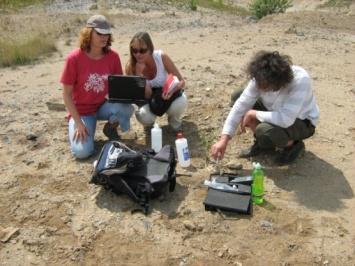
2 EO-MINERS ( ) EO-MINERS was a Research and Technological Developement project funded by the European Commission To help EC improve its raw material policy and better exploiting mineral resources from the European territory To demonstrate how to improve the capacity of Europe in implementing new mining sites To improve interaction between the mining industry and society Sientifc objective 1: Define environmental, socio-economic, societal and sustainable development criteria and indicators to be possibly dealt with EO Scientific objective 2: Demonstrate the capabilities of integrated EObased methods and tools in: monitoring, managing Contributing to reducing the environmental and societal footprints of all phases of a mining project
 Anglo Technical Division Tel-Aviv University Israel Université de Versailles St Quentin South Africa France Deutsches Zentrum")
3 EO-MINERS ( ) CZ(2) DE(2) KG(2) Beneficiary name Country Beneficiary name Country (BRGM) Bureau de Recherches France Council for Geoscience South Africa Géologiques et Minières UK(2) Coordination British Geological Survey UK Anglo Operations Limited, FR(2) Anglo Technical Division Tel-Aviv University Israel Université de Versailles St Quentin South Africa France Deutsches Zentrum für Luft - und Raumfahrt e.v. Germany Česká Geologická Služba Czech SI(1) IL(1) Republic Wuppertal Institut für Klima, Umwelt, Energie GmbH Germany Sokolovská Uhelná a.s. Czech Republic Geoloski Zavod Slovenije Slovenia ZA(2) Central Asian Institute for Applied Geoscience Mineral Industry Research Organisation Kyrgyzstan UK KyrgyzAltyn Kyrgyzstan 3 demonstration sites (CZ, ZA, KG)


4 EO-MINERS ( ) Expert knowledge Indicators EO methods and tools EO-based monitoring products On-site investigations Stakeholder interviews Trialogue workshops Stakeholder feedback

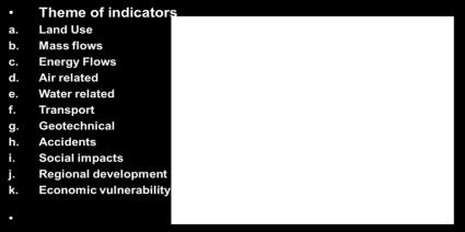
5 EO-MINERS INDICATORS


6 EO-MINERS SITE-SPECIFIC INDICATORS Sokolov Cz MALAHLENI SA Makmal Ky


: A6,")

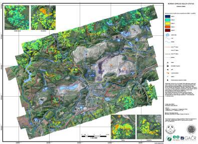
7 Sokolov: Indicators and products Apparent Thermal Inertia (ATI): A6, A9, G3 ph: E4, A8, A9 Fediss: E4, A8


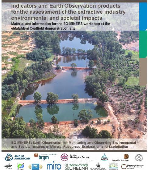
8 MALAHLENI: Indicators and products CHANGE OF THE MINING FOOTPRINT THROUGH TIME: A6, A9, G3 Dust Pollution (Indicator Geotechnical D1) hazard: mining-related fires (Indicators G4) Indicators: E4, A8, A9


9 MAKMAL: Indicators and products Soil and surface water contamination potential:e2 Tailings dam stability:g3
10 EO-MINERS: EO product types Project results are provided in a number of form, each designed to explain results to a range of stakeholders Reports Digital layers Paper maps Digital maps Animated over-flies Sokolov (Czech Republic) Witbank (South Africa) Makmal (Kyrgystan) Each with associated information and validation histories


11 EO-MINERS: product list Mineral Mapping used for water quality assessment Dust pollution and vegetation health

12 EO-MINERS ( ) European Stakeholder Dialogue on Impact Assessment on Mineral Exploration and Exploitation using Earth Observation
13 EO-MINERS ( ) Direct links to the booklets are available
EO-MINERS and Minerals 4EU
 GEO-CRADLE pre-kick-off Meeting Friday, 18 th of February, 2016 Veronika Kopačková, Czech Geological Survey EO-MINERS and Minerals 4EU IONIC Centre, 11 Lysiou Street Athens, Greece EO-MINERS (2010-2013)
EO-MINERS. Contribution of Earth Observation in monitoring the environmental and societal impact of mining. The EO-MINERS project
 EO-MINERS Contribution of Earth Observation in monitoring the environmental and societal impact of mining The EO-MINERS project Geospatial World Forum Amsterdam April 25, 2012 Stéphane CHEVREL Project
Feasibility Study: GEOSCIENTIFIC KNOWLEDGE AND SKILLS OF AFRICAN GEOLOGICAL SURVEYS. WP 3 - Gap analysis of geoscientific mapping
 Feasibility Study: GEOSCIENTIFIC KNOWLEDGE AND SKILLS OF AFRICAN GEOLOGICAL SURVEYS WP 3 - Gap analysis of geoscientific mapping Acquisition of metadata to geological maps as base for the compilation of
Change Detection Over Sokolov Open Pit Mine Areas, Czech Republic, Using Multi Temporal HyMAP Data ( )
") Change Detection Over Sokolov Open Pit Mine Areas, Czech Republic, Using Multi Temporal HyMAP Data (2009 2010) S. Adar* a G. Notesco b, A. Brook b, I. Livne b, P. Rojik c, V. Kopackova d, K. Zelenkova
Change Detection Over Sokolov Open Pit Mine Areas, Czech Republic, Using Multi Temporal HyMAP Data (2009 2010) S. Adar* a G. Notesco b, A. Brook b, I. Livne b, P. Rojik c, V. Kopackova d, K. Zelenkova
EU GeoCapacity. Assessing European Capacity for Geological Storage of Carbon Dioxide. Thomas Vangkilde-Pedersen, GEUS
 EU GeoCapacity Assessing European Capacity for Geological Storage of Carbon Dioxide Thomas Vangkilde-Pedersen, GEUS GeoCapacity results and the future for geological storage of CO 2 EU GeoCapacity open
Copernicus for Raw Materials Workshop
 Copernicus for Raw Materials Workshop Copernicus 40 User Years Forum Listening Industry Workshop, to the Beat 5th September of the Earth 2016, Brussels About http://copernicus.eu/raw-materials-workshop
OVERALL PROGRAMME. Sunday 16 October 2016:
 Sunday 16 October 2016: OVERALL PROGRAMME - Arrival in Morocco (landing either in Casablanca, with transfers to hotel to be organized by EGS, or Rabat) - Hosted dinner for the European Geological Surveys,
a national geological survey perspective François ROBIDA BRGM (French Geological Survey)
") a national geological survey perspective François ROBIDA BRGM (French Geological Survey) Pre-Conference Seminar on Socio-Economic Value of Geospatial for National and Regional Development 21 August 2017,
a national geological survey perspective François ROBIDA BRGM (French Geological Survey) Pre-Conference Seminar on Socio-Economic Value of Geospatial for National and Regional Development 21 August 2017,
EuroGeoSurveys & ASGMI The Geological Surveys of Europe and IberoAmerica
 EuroGeoSurveys & ASGMI The Geological Surveys of Europe and IberoAmerica Geological Surveys, what role? Legal mandate for data & information: Research Collection Management Interpretation/transformation
Land Cover and Land Use Diversity Indicators in LUCAS 2009 data
 Land Cover and Land Use Diversity Indicators in LUCAS 2009 data A. Palmieri, L. Martino, P. Dominici and M. Kasanko Abstract Landscape diversity and changes are connected to land cover and land use. The
40 Years Listening to the Beat of the Earth
 EuroGeoSurveys The role of EuroGeoSurveys in Europe-Africa geoscientific cooperation 40 Years Listening to the Beat of the Earth EuroGeoSurveys 32 Albania Lithuania Austria Luxembourg Belgium The Netherlands
Plan4all (econtentplus project)
") Plan4all (econtentplus project) Karel CHARVAT 1, Tomáš MILDORF 2 1 Help service remote sensing, Ltd., Černoleská 1600, 256 01 Benešov u Prahy, Czech Republic charvat@bnhelp.cz 2 Department of Mathematics
Plan4all (econtentplus project) Karel CHARVAT 1, Tomáš MILDORF 2 1 Help service remote sensing, Ltd., Černoleská 1600, 256 01 Benešov u Prahy, Czech Republic charvat@bnhelp.cz 2 Department of Mathematics
The EuCheMS Division Chemistry and the Environment EuCheMS/DCE
 The EuCheMS Division Chemistry and the Environment EuCheMS/DCE EuCheMS Division on Chemistry and the Environment was formed as a FECS Working Party in 1977. Membership: 37 members from 34 countries. Countries
Geological information for Europe : Towards a pan-european Geological Data Infrastructure
 Geological information for Europe : Towards a pan-european Geological Data Infrastructure Integrating geoscientific information for EU competitiveness Co-funded by the European Union European societal
Advancing Geoscientific Capability. Geological Survey of Finland
 Advancing Geoscientific Capability Geological Survey of Finland GTK in brief The Geological Survey of Finland (GTK) is one of the largest European centres of excellence in assessment, research and the
A contribution to GEOSS from the SDI for Georesources in Africa
 A contribution to GEOSS from the SDI for Georesources in Africa A. TELLEZ-ARENAS BRGM, France in behalf of: Dr. Marc URVOIS Project Coordinator BRGM, France Mineral Resources Division INSPIRE Conference
EXPERT ANALYSIS ON GEOGRAPHICAL SPECIFICITIES
 EXPERT ANALYSIS ON GEOGRAPHICAL SPECIFICITIES Mountains, Islands and Sparsely Populated Areas Dr. Gilda Carbone 9 Oct 2018 Objectives: to gather basic information from relevant programming documents (PAs,
Geo-hazard Potential Mapping Using GIS and Artificial Intelligence
 Geo-hazard Potential Mapping Using GIS and Artificial Intelligence Theoretical Background and Uses Case from Namibia Andreas Knobloch 1, Dr Andreas Barth 1, Ellen Dickmayer 1, Israel Hasheela 2, Andreas
COMMISSION OF THE EUROPEAN COMMUNITIES COMMISSION STAFF WORKING DOCUMENT. Annexes accompanying the
 EN EN EN COMMISSION OF THE EUROPEAN COMMUNITIES Brussels, 20.5.2009 SEC(2009) 684 COMMISSION STAFF WORKING DOCUMENT Annexes accompanying the REPORT FROM THE COMMISSION TO THE EUROPEAN PARLIAMENT AND THE
Pilot applications for Greece and Egypt related end-users
 GEO-CRADLE Project Meeting 2 16 th November, 2016 Pilot applications for Greece and Egypt related end-users Panagiotis Kosmopoulos & Hesham El-Askary National Observatory of Athens Chapman University Eratosthenes
GeoERA Raw Materials Mineral Intelligence for Europe (MINTELL4EU)
") GeoERA Raw Materials Mineral Intelligence for Europe (MINTELL4EU) Improving and sustaining the EURMKB Pedro Delgado Department of Geological Resources Research GEOLOGICAL SURVEY OF SPAIN Horizon 2020 Co-funded
GeoERA Raw Materials Mineral Intelligence for Europe (MINTELL4EU) Improving and sustaining the EURMKB Pedro Delgado Department of Geological Resources Research GEOLOGICAL SURVEY OF SPAIN Horizon 2020 Co-funded
Addressing GEO-CRADLE regional challenges - Access to raw materials MINUTES
 Observation Activities in the regions of North Africa, Middle East, and Addressing GEO-CRADLE regional challenges - Access to raw materials MINUTES The GEO-CRADLE project has received funding from the
LCA/RMF/MFA. Some elements
 LCA/RMF/MFA Some elements Position of the question The metals cycles The metals stocks > 4 Increased interlinkage of metals in products Stakes (cf. Raw Materials Initiative) > A method for mapping flows
EMODne Entry Portal Steering Committee, Brussels, 16 December Alan Stevenson, Jonathan Lowndes (British Geological Survey) and the project team
 and the project team") EMODnet Geology EMODne Entry Portal Steering Committee, Brussels, 16 December 2013 Alan Stevenson, Jonathan Lowndes (British Geological Survey) and the project team Background 14 organisations participated
EMODnet Geology EMODne Entry Portal Steering Committee, Brussels, 16 December 2013 Alan Stevenson, Jonathan Lowndes (British Geological Survey) and the project team Background 14 organisations participated
COMMISSION (2001/793/EC) Having regard to the Treaty establishing the European Community,
 Having regard to the Treaty establishing the European Community,") L 297/12 EN Official Journal of the European Communities 15.11.2001 COMMISSION COMMISSION DECISION of 9 November 2001 amending Decision 2000/585/EC as regards imports of wild farmed feathered game meat
L 297/12 EN Official Journal of the European Communities 15.11.2001 COMMISSION COMMISSION DECISION of 9 November 2001 amending Decision 2000/585/EC as regards imports of wild farmed feathered game meat
Model Generalisation in the Context of National Infrastructure for Spatial Information
 Model Generalisation in the Context of National Infrastructure for Spatial Information Tomas MILDORF and Vaclav CADA, Czech Republic Key words: NSDI, INSPIRE, model generalization, cadastre, spatial planning
EuroGeoSurveys An Introduction
 EGS -ASGMI Workshop, Madrid, 2015 EuroGeoSurveys An Introduction 40 Years Listening to the Beat of the Earth Click to edit Master title Albania style EuroGeoSurveys Austria Lithuania Luxembourg Belgium
GEOCONSERVATION (GEOPARKS) CASE STUDY
 CASE STUDY") International Spring School on Sustainable Development 2014 30 March - 5 April 2014 in Týnec nad Sázavou, Czech Republic GEOCONSERVATION (GEOPARKS) CASE STUDY Alexandru Andrăşanu University of Bucharest,
International Spring School on Sustainable Development 2014 30 March - 5 April 2014 in Týnec nad Sázavou, Czech Republic GEOCONSERVATION (GEOPARKS) CASE STUDY Alexandru Andrăşanu University of Bucharest,
The contributions of the EU-funded MEDiterranean SUpersite Volcanoes (MED-SUV) project to the assessment of volcanic ash hazard
 project to the assessment of volcanic ash hazard") The contributions of the EU-funded MEDiterranean SUpersite Volcanoes (MED-SUV) project to the assessment of volcanic ash hazard S.Barsotti, F.Buongiorno, M.Coltelli, A.Costa, E.Del Bello, M.de Michieli
The contributions of the EU-funded MEDiterranean SUpersite Volcanoes (MED-SUV) project to the assessment of volcanic ash hazard S.Barsotti, F.Buongiorno, M.Coltelli, A.Costa, E.Del Bello, M.de Michieli
Spatially enabling e-government through geo-services
 Spatially enabling e-government through geo-services Mauro Salvemini EUROGI PRESIDENT Professor at Sapienza Università di Roma (IT) 1 About the presentation Few information about Eurogi ; Some essential
EuroGeoSource: sharing data and services on energy and mineral resources in Europe following INSPIRE
 EuroGeoSource: sharing data and services on energy and mineral resources in Europe following INSPIRE Rubén Béjar 1, Miguel Usón 2, Jesús Barrera 2, Rocío Recio 1, José M. Agudo 1, F. Javier Zarazaga-Soria
40 Years Listening to the Beat of the Earth
 EU-LA Mining & Exploration Convention Earth Observation in support of sustainable mining by the Geological Surveys of Europe Gerardo Herrera Veronika Kopačková Eleftheria Poyiadji Maria Przyłucka 40 Years
Biodiversity and Ecosystem services Thinking globally, acting locally
 Biodiversity and Ecosystem services Thinking globally, acting locally Anne-Gaelle Ausseil - Manaaki Whenua Landcare Research Geoff Hicks National Commission for UNESCO 1 8 / 1 0 / 2 0 1 8 M A N A A K I
Evaluating Sustainability of the Georesources Observation System
 Evaluating Sustainability of the Georesources Observation System Michael Mente Federal Institute for Geosciences and Natural Resources Germany, Hannover GEOSS-CBC Meeting Athens April 27th 28th, 2009 GEOSS-CBC
Community Engagement in Cultural Routes SiTI Higher Institute on Territorial Systems for Innovation Sara Levi Sacerdotti
 Transnational Workshop Wroclaw, 7th-8th December 2016 Community Engagement in Cultural Routes SiTI Higher Institute on Territorial Systems for Innovation Sara Levi Sacerdotti levi@siti.polito.it TAKING
SPLAN-Natura Towards an integrated spatial planning approach for Natura th January, 2017 Brussels. Commissioned by DG Environment
 SPLAN-Natura 2000 Towards an integrated spatial planning approach for Natura 2000 Commissioned by DG Environment 17 th January, 2017 Brussels V. Simeonova (Ph.D.) Drivers towards integrating Biodiversity
Interoperability of Spatial Planning Data
 INSPIRE Conference 2010, Krakow, Poland Interoperability of Spatial Planning Data European Network of Best Practices for Interoperability of Spatial Planning Information Tomas Mildorf mildorf@centrum.cz
Territorial evidence for a European Urban Agenda TOWN in Europe
 Territorial evidence for a European Urban Agenda TOWN in Europe Loris Servillo Brussels, 25 November 2014 Outline 1. SMSTs in the EU territory 2. General vs specific trends? 3. Evidences for more appropriated
The future of SDIs. Ian Masser
 The future of SDIs Ian Masser Presentation Considers two questions relating to the future development of SDIs throughout the world Where have we got to now? Where should we go from here? Identifies four
UNESCO s Earth Science. Education Initiative in Africa. United Nations Educational, Scientific and Cultural Organization
 UNESCO s Earth Science Education Initiative in Africa United Nations Educational, Scientific and Cultural Organization Few milestones First International Conference on African and Arabian Geoparks 2011,
No. Title Column1 Type SJR H index Cites / Doc. 1 Energy and Environmental Sciences ISSN journal
 1 Energy and Environmental Sciences ISSN 17545692 journal 10.475 158 25.1 2 Annual Review of Ecology, Evolution, and Systematics ISSN 1543592X journal 9.624 165 9.55 States 3 Nature Climate Change ISSN
EU BON Building the European Biodiversity Observation Network
 EU BON Building the European Biodiversity Observation Network Christoph L. Häuser christoph.haeuser@mfn-berlin.de Museum für Naturkunde - Leibniz Institute for Research on Evolution and Biodiversity Berlin,
WHO EpiData. A monthly summary of the epidemiological data on selected Vaccine preventable diseases in the WHO European Region
 A monthly summary of the epidemiological data on selected Vaccine preventable diseases in the WHO European Region Table 1: Reported cases for the period January December 2018 (data as of 01 February 2019)
Supporting GPSC Cities with Satellite Earth Observation for Sustainable Urban Development
 Supporting GPSC Cities with Satellite Earth Observation for Sustainable Urban Development Global Platform for Sustainable Cities African Regional Workshop 14 May 2018 AfDB Headquarters Abidjan, Côte d'ivoire
Call for Applications
 Call for Applications for a PanAfGeo Training «WP1 Geoscientific Mapping, part WP1E1 Remote Sensing» 20-30 November 2017, Bishoftu, Ethiopia in English 1. MAIN CONTEXT OF PANAFGEO PanAfGeo for Pan-African
From SARA (Germany)*) (= Satellitengestütztes Raummonitoring) to SASMO**) (=Satellite based spatial monitoring for Europe)
*) (= Satellitengestütztes Raummonitoring) to SASMO**) (=Satellite based spatial monitoring for Europe)") From SARA (Germany)*) (= Satellitengestütztes Raummonitoring) to SASMO**) (=Satellite based spatial monitoring for Europe) *) This cooperative project, funded by the Brandenburg Ministry for Economic Affairswas
From SARA (Germany)*) (= Satellitengestütztes Raummonitoring) to SASMO**) (=Satellite based spatial monitoring for Europe) *) This cooperative project, funded by the Brandenburg Ministry for Economic Affairswas
Project EuroGeoNames (EGN) Results of the econtentplus-funded period *
 Results of the econtentplus-funded period *") UNITED NATIONS Working Paper GROUP OF EXPERTS ON No. 33 GEOGRAPHICAL NAMES Twenty-fifth session Nairobi, 5 12 May 2009 Item 10 of the provisional agenda Activities relating to the Working Group on Toponymic
UNITED NATIONS Working Paper GROUP OF EXPERTS ON No. 33 GEOGRAPHICAL NAMES Twenty-fifth session Nairobi, 5 12 May 2009 Item 10 of the provisional agenda Activities relating to the Working Group on Toponymic
Launch of the ESPON 2013 Programme. European observation network on territorial development and cohesion
 Launch of the ESPON 2013 Programme European observation network on territorial development and cohesion Framework conditions for the ESPON 2013 Programme Policy development in use of territorial evidence
Pilot applications for Egypt related end-users
 GEO-CRADLE Regional Workshop Thursday, 25 th May, 2017 Pilot applications for Egypt related end-users Hesham El-Askary Chapman University Panagiotis Kosmopoulos National Observatory of Athens Stelios Kazadzis
SDG s and the role of Earth Observation
 SDG s and the role of Earth Observation Christian Heipke IPI - Institute for Photogrammetry and GeoInformation Leibniz Universität Hannover Germany Secretary General, ISPRS 1. No Poverty 2. Zero Hunger
International Union of Geodesy and Geophysics. Resolutions
 International Union of Geodesy and Geophysics Resolutions ADOPTED BY THE COUNCIL AT THE XXVI GENERAL ASSEMBLY PRAGUE, CZECH REPUBLIC (22 JUNE 2 JULY 2015) 0 Page Resolution 1: Role of Ocean in Climate
Zambia - Mining and Environmental Remediation and Improvement Project (P154683)
") AFRICA Zambia Environment & Natural Resources Global Practice IBRD/IDA Investment Project Financing FY 2017 Seq No: 4 ARCHIVED on 26-Nov-2018 ISR34605 Implementing Agencies: Ministry of Mines and Mineral
AFRICA Zambia Environment & Natural Resources Global Practice IBRD/IDA Investment Project Financing FY 2017 Seq No: 4 ARCHIVED on 26-Nov-2018 ISR34605 Implementing Agencies: Ministry of Mines and Mineral
EuroGeoSurveys. Minerals, metals and mining statistics: The role of Geological Surveys in building continental-scale official data sets
 EuroGeoSurveys Minerals, metals and mining statistics: The role of Geological Surveys in building continental-scale official data sets 40 Years Listening to the Beat of the Earth 1 EuroGeoSurveys 37 Geological
Transparent, equitable and optimal exploitation of mineral resources to underpin broad-based sustainable growth and socio-economic development
 Mining in Africa African Mining Vision 2050: Transparent, equitable and optimal exploitation of mineral resources to underpin broad-based sustainable growth and socio-economic development Revenues generated
Improving rural statistics. Defining rural territories and key indicators of rural development
 Improving rural statistics Defining rural territories and key indicators of rural development Improving rural statistics Improving Rural Statistics In 2016, the Global Strategy to improve Agricultural
A1 - Total Land Use by Mining and Milling topographical footprint
 A. LAND-USE A1 - Total Land Use by Mining and Milling topographical footprint Topographical Footprint: The total areal footprint (2-dimensional) used by the mine/mill is an overarching proxy for a variety
Improvements for Kosovo's spatial planning system / [presentation given in May 2011]
![Improvements for Kosovo's spatial planning system / [presentation given in May 2011]](/thumbs/95/122511393.jpg "Improvements for Kosovo's spatial planning system / [presentation given in May 2011]") Rochester Institute of Technology RIT Scholar Works Theses Thesis/Dissertation Collections 2011 Improvements for Kosovo's spatial planning system / [presentation given in May 2011] Luan Nushi Follow this
Rochester Institute of Technology RIT Scholar Works Theses Thesis/Dissertation Collections 2011 Improvements for Kosovo's spatial planning system / [presentation given in May 2011] Luan Nushi Follow this
Die Deutsche Rohstoffagentur (German Mineral Resources Agency) - Background and Concept -
 - Background and Concept -") Die Deutsche Rohstoffagentur (German Mineral Resources Agency) - Background and Concept - Dr. Hildegard Wilken Head of Sub-Department Economic Geology of Mineral Resources Federal Institute for Geosciences
Die Deutsche Rohstoffagentur (German Mineral Resources Agency) - Background and Concept - Dr. Hildegard Wilken Head of Sub-Department Economic Geology of Mineral Resources Federal Institute for Geosciences
ACCESSIBILITY TO SERVICES IN REGIONS AND CITIES: MEASURES AND POLICIES NOTE FOR THE WPTI WORKSHOP, 18 JUNE 2013
 ACCESSIBILITY TO SERVICES IN REGIONS AND CITIES: MEASURES AND POLICIES NOTE FOR THE WPTI WORKSHOP, 18 JUNE 2013 1. Significant differences in the access to basic and advanced services, such as transport,
Poland, European Territory, ESPON Programme Warsaw, 2 July 2007 STRATEGY OF THE ESPON 2013 PROGRAMME
 Poland, European Territory, ESPON Programme 2007-2013 Warsaw, 2 July 2007 STRATEGY OF THE ESPON 2013 PROGRAMME Territory matters Regional diversity as asset Territorial potentials increasing in importance
GEOCHEMISTRY RESEARCH GROUP projects & research
 PATHWAY GEOCHEMISTRY RESEARCH GROUP projects & research MOROCCO-HUNGARY Bilateral Project Meknes 2012 GYOZO JORDAN Geochemistry Department, Hungarian Geological and Geophysical Institute RECEPTOR SOURCE
Space Applications for Disaster Risk Reduction and Sustainable Development
 Space Applications for Disaster Risk Reduction and Sustainable Development Space Applications Section (SAS) ICT and Disaster Risk Reduction Division (IDD) UNESCAP Contents I. RESAP Activities 2016-2017
International Conference Analysis and Management of Changing Risks for Natural Hazards November 2014 l Padua, Italy
 Abstract Code: B01 Assets mapping products in support of preparedness and prevention measures (examples from Germany, Italy and France) Marc Mueller, Thierry Fourty, Mehdi Lefeuvre Airbus Defence and Space,
Assessment and Improvement of Methodologies used for GHG Projections
 Assessment and Improvement of Methodologies used for GHG Projections Jan Duerinck Etsap workshop 3 July 2008 Paris Who is using Markal and how Jan Duerinck Etsap workshop 3 July 2008 Paris 1 Outline of
Non-Governmental Organizations for Spatial Data Infrastructure. Environmental Democracy Case
 Non-Governmental Organizations for Spatial Data Infrastructure Environmental Democracy Case L.Jovičić, S.Vrečar, V.Cetl, K.Ristovski GSDI Small Grant Program Award 2011-2012 Non-Governmental Organisations
Alps Results from the ESPON Project. Common spatial perspectives for the Alpine area. Towards a common vision
 Results from the ESPON Project Alps 2050 Common spatial perspectives for the Alpine area. Towards a common vision Tobias Chilla, University of Erlangen Cooperation Alps 2020+ 1 & 2 October 2018 Salzburg
Use of climate reanalysis for EEA climate change assessment. Blaz Kurnik. European Environment Agency (EEA)
") Use of climate reanalysis for EEA climate change assessment Blaz Kurnik European Environment Agency (EEA) 2016: EEA content priorities Circular economy Climate and Energy Sustainable Development Goals
Use of climate reanalysis for EEA climate change assessment Blaz Kurnik European Environment Agency (EEA) 2016: EEA content priorities Circular economy Climate and Energy Sustainable Development Goals
Max Planck Institute for Chemistry, Multiphase Chemistry Department, Mainz, Germany 2. University of Novi Sad, Faculty of Sciences, Novi Sad, Serbia 4
 Chemistry in Environmental Sciences Related Higher Education (BSc and MSc) Programmes in Europe Gerhard Lammel 1,2, Ivana Ivancev-Tumbas 3, Eric Jover Comas 4 1 Max Planck Institute for Chemistry, Multiphase
Access to MRM deposits in European countries and associated territories. Case Study: Aggregates plans and their future:
 WP6 Foresight study Access to MRM deposits in European countries and associated territories Case Study: Aggregates plans and their future: a view from South East Europe (SEE) countries Minerals4EU Final
EAGLE Data Model and Outcomes of HELM (Harmonised European Land Monitoring)
") EAGLE Data Model and Outcomes of HELM (Harmonised European Land Monitoring) Contribution towards better land information harmonisation and INSPIRE compliance EAGLE working group Stephan Arnold, Barbara
EAGLE Data Model and Outcomes of HELM (Harmonised European Land Monitoring) Contribution towards better land information harmonisation and INSPIRE compliance EAGLE working group Stephan Arnold, Barbara
CO 2 -water-rock reactivity at hydrothermal temperatures: The BigRig2 experiment
 CO 2 -water-rock reactivity at hydrothermal temperatures: The BigRig2 experiment C.A. ROCHELLE 1 *, K. BATEMAN 1, A. LACINSKA 1, D. WAGNER 1, J. LIONS 2 AND I. GAUS 2 1 British Geological Survey, Keyworth,
University of Mining and Geology
 University of Mining and Geology University of Mining and Geology 1. Introduction 2. The study at UMG 3. The research at UMG 4. International Cooperation University of Mining and Geology 1. Introduction
The Infrastructure for Spatial Information in the European Community vs. regional SDI: the shortest way for reaching economic and social development
 The Infrastructure for Spatial Information in the European Community vs. regional SDI: the shortest way for reaching economic and social development Mauro Salvemini EUROGI PRESIDENT Professor at Sapienza
GEO-CRADLE Project Meeting 2 Thursday, 17 th November, 2016
 GEO-CRADLE Project Meeting 2 Thursday, 17 th November, 2016 T4.3 EGS-PGI NRI Marek Graniczny (EGS PGI) Maria Przyłucka (EGS PGI) Eleftheria Poyiadji (EGS-IGME-Greece) Zbigniew Kowalski (EGS PGI) Christodoulos
Spatially Enabled Society
 International Seminar on Land Administration Trends and Issues in Asia and the Pacific Region Spatially Enabled Society Abbas Rajabifard Vice Chair PCGIAP-WG3 Vice-President (President Elect), GSDI Association
French research capacities in the South Pacific: New Caledonia
 French research capacities in the South Pacific: New Caledonia FRAN - French Researchers in Australia Network Fourth Annual Forum Brisbane 24-25 August 2015 Key features of research in New-Caledonia 1
Bengt Kjellson Chair of the Executive Committee UN-GGIM: Europe. 2 nd Joint UN-GGIM: Europe ESS Meeting 11 th March 2016, Luxembourg
 Bengt Kjellson Chair of the Executive Committee UN-GGIM: Europe 2 nd Joint UN-GGIM: Europe ESS Meeting 11 th March 2016, Luxembourg A global geospatial mandate At its 47th plenary in July 2011, ECOSOC,
Tellus Border Project Overview. Marie Cowan Ph.D Project Manager
 Tellus Border Project Overview Marie Cowan Ph.D Project Manager Presentation Outline History Goals Partners Project summary Legislative Framework Data Impacts Tellus History Proposed by GSNI, GSI, and
GLOBAL NETWORK OF NATIONAL GEOPARKS. Patrick J Mc Keever
 Patrick J Mc Keever A GEOPARK is an area with. geological heritage of international significance but also with. a sustainable development strategy or plan involving local communities. IS A GEOPARK JUST
Cooperating Country Report of GERMANY
 CCOP-47AS/4.1-19 COORDINATING COMMITTEE FOR GEOSCIENCE PROGRAMMES IN EAST AND SOUTHEAST ASIA (CCOP) 47 th CCOP Annual Session 17-21 October 2010 Manado, Indonesia Cooperating Country Report of GERMANY
Investigation, assessment and warning zonation for landslides in the mountainous regions of Vietnam
 Investigation, assessment and warning zonation for landslides in the mountainous regions of Vietnam (State-Funded Landslide Project SFLP) Dr. Eng. Le Quoc Hung Add: 67 Chien Thang Street, Ha Dong District,
Subcommittee on Sedimentation Draft Sediment Analysis Guidelines for Dam Removal
 Subcommittee on Sedimentation Draft Sediment Analysis Guidelines for Dam Removal August 4, 2011 Jennifer Bountry, M.S., P.E. Tim Randle, M.S., P.E., D.WRE. Blair Greimann, Ph.D., P.E. Sedimentation and
Introduction of Remote Sensing Methods for Monitoring the Under Restoration Amiantos Mine, Cyprus
 Sixth International Conference on Remote Sensing and Geoinformation of Environment, 26-29 March, 2018 - Cyprus Introduction of Remote Sensing Methods for Monitoring the Under Restoration Amiantos Mine,
Geological Survey of Canada Lands and Minerals Sector Natural Resources Canada OneGeology, June 2018
 Geological Survey of Canada Lands and Minerals Sector Natural Resources Canada OneGeology, June 2018 Geological Survey of Canada Mission The Geological Survey of Canada provides public geoscience knowledge
UNITED NATIONS ECONOMIC COMMISSION FOR EUROPE. Road Maps for Mainstreaming Ageing
 UNITED NATIONS ECONOMIC COMMISSION FOR EUROPE Population Unit www.unece.org/pau Road Maps for Mainstreaming Ageing Fiona Willis Núñez fiona.willis nunez@unece.org Sub-Regional Capacity Development Workshop
16540/14 EE/cm 1 DG E 1A
 Council of the European Union Brussels, 5 December 2014 (OR. en) 16540/14 ENV 965 CULT 139 NOTE From: To: Subject: General Secretariat of the Council Delegations Charter of Rome on Natural and Cultural
1 INTRODUCTION. 1.1 Context
 1 INTRODUCTION 1.1 Context During the last 30 years ski run construction has been one of the major human activities affecting the Alpine environment. The impact of skiing on environmental factors and processes,
ICANN s Geographic Regions
 9 Dec 2010 ICANN s Geographic Regions Cartagena ICANN s Geographic Regions Dave Archbold Chairman, WGGR 9 Dec 2010 ICANN s Geographic Regions Cartagena Initial Purpose of ICANN Regions Geographic Regions
THE 3-REGIONS WORKING GROUP SLOPE INSTABILITIES (SlopeIn)
") Bayerisches Landesamt für Umwelt THE 3-REGIONS WORKING GROUP SLOPE INSTABILITIES (SlopeIn) COMMON LANGUAGE, COMPARABLE HAZARD MAPPING AND SHARED EXPERIENCES ACROSS EUROPE The 3-Regions Working-Group SlopeIn:
Bayerisches Landesamt für Umwelt THE 3-REGIONS WORKING GROUP SLOPE INSTABILITIES (SlopeIn) COMMON LANGUAGE, COMPARABLE HAZARD MAPPING AND SHARED EXPERIENCES ACROSS EUROPE The 3-Regions Working-Group SlopeIn:
Spatial Data Infrastructure in the Pacific
 Spatial Data Infrastructure in the Pacific. Sachindra Singh Senior Geospatial Systems Architect ICT for Development, Geoscience Division Pacific Community (SPC) OrganisationalBackground SPC - The Pacific
Biodiversity data, current gaps and work package efforts
 Biodiversity data, current gaps and work package efforts Florian T. Wetzel 1, Veljo Runnel 2, Anton Güntsch 3, Urmas Köljalg 2 1 Museum für Naturkunde Berlin - Leibniz Institute for Evolution and Biodiversity
INSPIRing effort. Peter Parslow Ordnance Survey December Various European approaches to managing an SDI
 INSPIRing effort Peter Parslow Ordnance Survey December 2015 Various European approaches to managing an SDI WHAT IS INSPIRE? A European Union Directive A community effort: http://inspire.ec.europa.eu/
COLLABORATIVE RESEARCH ON EAST AFRICA TERRITORY INTEGRATION WITHIN GLOBALISATION
 Presentation by Prof. Bernard Charlery de la Masselière Coordinator CREATING C.R.E.A.T.IN.G. A EU/SSH COORDINATING ACTION COLLABORATIVE RESEARCH ON EAST AFRICA TERRITORY INTEGRATION WITHIN GLOBALISATION
Space Weather & Critical Infrastructures
 Space Weather & Critical Infrastructures Italy Organisers EC JRC, MSB, UK Met Office Date and Venue 29-30 November 2016, JRC Ispra, Background Our modern technological infrastructures on the ground and
Use of geo-referenced data for DRM in Central Asia, problems and prospective
 Use of geo-referenced data for DRM in Central Asia, problems and prospective Dr. Akylbek Chymyrov Director, Kyrgyz Center of Geoinformation Systems Member of the Public Supervisory Board MES KR KSUCTA,
Catalysing Innovation in Weather Science - the role of observations and NWP in the World Weather Research Programme
 Catalysing Innovation in Weather Science - the role of observations and NWP in the World Weather Research Programme Estelle de Coning, Paolo Ruti, Julia Keller World Weather Research Division The World
Report on the establishment of UN GGIM: Europe Item 14. 4th session of the Committee of Experts on UN-GGIM
 Report on the establishment of UN GGIM: Europe Item 14 1 Why regional European committees of UN GGIM? In the ECOSOC resolution 2011/24 on the UN GGIM: Emphasizes the importance of promoting national, regional
Trade Sustainability Impact Assessment in support of negotiations of a DCFTA between the EU and Egypt
 Trade Sustainability Impact Assessment in support of negotiations of a DCFTA between the EU and Egypt Annexes to the final Interim Technical Report Client: European Commission - DG TRADE Rotterdam, 30
United 1. ISSN , Q1 111 Nature Geoscience. Kingdom 2 Earth System Science Data ISSN , Q1 12 Germany 3
 Bidang: Earth and Planetary Sciences Kategori: Earth and Planetary Sciences Update: 3 Mei 2017 Oleh: Mohammad Heriyanto (mheriyanto.wordpress.com) Fisika Bumi dan Sistem Kompleks, ITB Ranking Judul ISSN
GSDI Global Spatial Data Infrastructure. Convergences between Geo Spatial Communities: key decision for decision making
 GSDI Global Spatial Data Infrastructure Convergences between Geo Spatial Communities: key decision for decision making April 14 th 2010 Bas Kok GSDI Past-President Director of International Affairs, Dutch