Research Article Habitat Preferences and Growth of Ruditapes bruguieri (Bivalvia: Veneridae) at the Northern Boundary of Its Range
|
|
|
- Ami Sutton
- 5 years ago
- Views:
Transcription
1 e Scientific World Journal, Article ID , 6 pages Research Article Habitat Preferences and Growth of Ruditapes bruguieri (Bivalvia: Veneridae) at the Northern Boundary of Its Range Alla V. Silina A.V. Zhirmunsky Institute of Marine Biology, Far East Branch of the Russian Academy of Sciences, Vladivostok , Russia Correspondence should be addressed to Alla V. Silina; allasilina@mail.ru Received 30 August 2013; Accepted 27 October 2013; Published 16 January 2014 Academic Editors: T. Klefoth and Y.-T. Qiu Copyright 2014 Alla V. Silina. This is an open access article distributed under the Creative Commons Attribution License, which permits unrestricted use, distribution, and reproduction in any medium, provided the original work is properly cited. This work is the first attempt to study growth and some morphological parameters of the clam Ruditapes bruguieri, aswellasits habitat preferences. It is found that R. bruguieri lives on bottom sediments including pebble and coarse- and medium-grained sand with a slight admixture of silt. At the study area, this bivalve inhabits sea waters with good aeration, stable oceanic water salinity, and a high oxygen concentration. The annual fluctuations of the water temperature from C (in winter) to C (in summer) are close to the threshold temperature values, within which the species can exist. Near the boundary of the species range, along the Jeju Island coasts, south of Republic of Korea, 83.8% of all clams die during the coldest period of the year. Here, annual rings are formed on R. bruguieri shells during winter. The maximum age of R. bruguieri, determined during the study, is 6.5 years, but the clam samples contain mainly individuals at years of age (34%). The largest clam dimensions are mm (length height of shell). At the study area, a usual shell length is mm (75% of all the collected individuals). 1. Introduction The marine Veneridae, which is the largest family of Bivalvia and one of the least studied and most poorly defined molluscan taxa, comprises approximately 800 species, including some of the most economically important and abundant ones [1]. Two species of the genus Ruditapes (Bivalvia: Veneroida: Veneridae) are found along the coasts of Korea: the Manila clam Ruditapes philippinarum (Adams et Reeve, 1848) and the clam Ruditapes bruguieri (Hanley, 1845) [2 5]. The commercial species R. philippinarum, including its populations in coastal waters of Korea, is considered in a variety of papers published, but studies on R. bruguieri are few in number, despite the latter species is widely spread in the Indo-West Pacific. According to OBIS Indo-Pacific Molluscan Database, , the synonyms of mollusk R. bruguieri are as follows: Paphia (Amygdala) bruguieri auct.; Venus bruguieri (Hanley, 1845); Tapes tessellata (Adams and Reeve), 1850; Tapes variegata (Sowerby, 1852); Ruditapes variegata (Sowerby, 1852); Tapes violacens (Deshayes, 1853); Tapes japonica (Deshayes, 1853); Tapes cinerea (Deshayes, 1854); Tapes punicea (Deshayes, 1854); and Tapes semidecussata (Reeve,1864).TherearealsosuchsynonymsasTapes bruguieri, Venerupis (Ruditapes) bruguieri,andvenerupis bruguieri. R. bruguieri is a tropical-subtropical species [2, 4]. It is distributed in the tropical Indo-West Pacific: Central and East Indian Ocean (West India and East India, Andhra Pradesh, Thailand, Andaman, and Nicobar), Indo-Malaysia (northwestern, northern, and northeastern coasts of Australia, Philippines, Indonesia, and Oceania), Papua New Guinea, China (South China Sea, including Hong Kong and East China Sea), and Japan [6 9]. It also occurs in the Temperate West Pacific of the Northern Hemisphere: South Korea, Korea Bay, and North China [2 5]. Huber [10] believes that the range of R. bruguieri is limited to the Indian Ocean. From Japan and Australia, only Ruditapes aspera (Quoy and Gaimard, 1835) is known, whereas both species occur in waters of India. Little is known about the biology and ecology of R. bruguieri. There are no data on growth of this bivalve species. Therefore, the present study investigates some ecological preferences and growth of R. bruguieri. Usually,surveys of populationsinhabitingmarginalareasofthespeciesrange are of particular interest for the study of biological and
2 2 The Scientific World Journal Sea of Japan Japan Lagoon Seongsan Sunrise Peak Jeju Island Figure 1: Sites of searches for Ruditapes bruguieri shells along the coasts of Jeju Island, South Korea. ecological characteristics of the species as in such cases it is possible to reveal threshold values of some environmental parameters that restrict the area of the species natural habitat. For instance, a sea water temperature at the northern boundary of species areal can indicate the thresholds of tolerant temperature limits for the species. As for the range of the tropical-subtropical R. bruguieri, its northern boundary runs particularly along the coasts of Korea, and, for this reason, the samples of R. bruguieri from the coastal waters of Jeju Island, SouthKorea,werestudiedinthework.Besides,acomparative analysis of ecological parameters of Jeju Island s bays, where R. bruguieri was or was not found by the author and other researchers, has been conducted with the use of the literature data to reveal ecological preferences of the species. Growth and morphometric data for the species were obtained using the clam shell samples from the littoral zones of Jeju Island, as it is known that samples from shell assemblages may be used for growth rate estimation of clams, and such samples give a more comprehensive appreciation of the maximum size and life span of the species than the sample of live mollusks from the natural habitat [11]. 2. Materials and Methods 2.1. Ecological Characteristics of Sites of Clam Collections. Jeju Island is a volcanic formation located about 80 km south of the mainland. Its coastline is mainly rocky with several sandy and pebble beaches. The warm Tsushima Current flowing from the southwest creates a subtropical climate on the island with an average annual water temperature of about 15 C [2, 4, 12]. In the studied area, the water salinity is normal, usually oceanic [12, 13]. The island is subject to moderate tides andstrongwaveaction[4]. Searches for clam R. bruguieri shells that were lying on thebeachwerecarriedoutinthelittoralzone(intheuppertide and mid-tide levels) of several bays situated on the northwestern, southern, and eastern coasts of Jeju Island during low tides in 2008 (Figure1). The sampling efforts were similar for all sites. Everywhere, the shells were collected from the area of about 350 m 2 (70 m 5m). Some of clam shell samples from the littoral zone of the northern, northwestern, southern, and eastern coasts of the island were kindly provided by K. A. Lutaenko (A.V. Zhirmunsky Institute of Marine Biology, FEB RAS (IMB FEB RAS)). The latter samples were collected in 2007, 2008, 2011, and These clam shells were also collected from the upper-tide and midtide levels of the littoral zones during low tides. On the eastern coast of Jeju Island, clam shells were looked for in two bays near Ojo-ri town. The littoral zone was examined both in the protected Seongsan lagoon ( N, E) and in the open bay ( N, E) at the cape with Sunrise Peak volcano (Figure 1). The lagoon is almost flat and shallow, protected from wave impacts by the cape. The bottom sediments of the lagoon are composed of sand with various grain size, pebble, and small boulders [14]. Here,
3 The Scientific World Journal 3 Table1:SizelimitsandgrowthratesoftheclamRuditapes bruguieri along the Jeju Island coast, South Korea. The mean values ± standard error of the mean and min max limits for shell parameters are shown. Area N Northern coast 12 Northwestern coast 12 Southern coast 13 Eastern coast 117 Shell size, mm Shell height at the respective annual ring, mm Length Height ± ± ± ± ± ± ± ± ± ± ± ± ± ± ± ± ± ± ± ± ± ± ± ± ± ± ± ± 0.2 shells of the clam R. bruguieri were not found. Silt constitutes 1% of the weight of dry soft sediments [15]. In the open bay, the littoral bottom sediments consist of middle-grained sand between volcanic reefs (basalt tectonic plates). Silt makes up 2% of the weight of dry soft sediments [15]. Here, a total of 117 clam shells were collected in 2007, 2008, and Also, attheopennorthernareaofthebeachatjongdal-ritown ( N, E), 11 clam shells were sampled in The open southern site was on Namo Beach ( N, E). Here, the littoral coastal bottom sediments consist of grey middle- and fine-grained sand in the upper-tide and mid-tide level, passing into silt (>63% of the weight of dry sediments) in the low-tide level [14, 15]. Only two clam shells were found in Also, on the open rocky Yerae coast, approximately 8 km west of Seogwipo city ( N, E), 11 clam shells were collected in 2011 and OnenorthwesternsitewassituatedonGeumneungBeach (Hallim Park) ( N, E), opposite to small Biyangdo Island. It is an open bay with the coastal bottom sediments composed of light coarse- and middlegrained sand with small admixture of silt (about 0.1%) among bigvolcanicboulders[14, 15]. Other sites on the northwestern coast of Jeju Island were situated on Kwakji Beach ( N E) and Hyupchae Beach ( N E). On the northwestern coasts, 12 clam shells were collected in 2008 and Near the northern (N-NE, Figure 1) coast of Jeju Island, R. bruguieri shells were sampled from organogenic sand of Hamdeok Beach (25 km southwest of Aewol town). Here, 12 clam shells were found in Clam Characteristics and Statistical Analysis. Shell length (L, mm, the longest distance between the anterior and posterior shell edges), shell height (H, mm), and shell width (D, mm, if both valves were available) were measured using sliding calipers to an accuracy of 0.1 mm. Age and growth rates of each individual were determined retrospectively by annual growth rings on the outer surface of the shell. As clam shell samples were not numerous, for subsequent comparison of growth rates, the samples were combined into four united samples (northwestern, northern, eastern, and southern samples) coast according to the geographic location of the samples (Figure 1,Table 1). The data were expressed as mean values ± standard error of the mean (SE). Prior to statistical analysis, all data were tested for normality of variance among the different groups by using a Kolmogorov-Smirnov test. The method of linear regression was used to reveal relationships between morphometric parameters of shell, as well as variations in the length/height ratio with age of mollusk. A Student s ttest was used to identify significant differences among mean shell heights for scallops of the same age at different sites. Data processing was done using STATISTICA, version 5.1, and Microsoft Office Excel, Data Analysis. 3. Results and Discussion 3.1. Habitat Preferences Bottom Sediments. The largest in number samples of R. bruguieri shells were collected on the middle- and coarsegrained sand and sand/gravel beaches on the open eastern coast of the island. However, shells of the studied bivalve species were almost absent on bottom sediments with a high content of fine-grained sand and silt at the southern site, Namo Beach. Earlier, shells of R. bruguieri were collected on the western littoral zone of small Seogundo Island, situated nearby Jeju Island [4]. Seogundo Island has a mainly rocky coastline with small sand and gravel areas [2]. Here, shells were also found on coarse-grained sand. Thus, these data can be sign for a conclusion that R. bruguieri prefers coarseand middle-grained sand with a slight admixture of silt. The silt content in the bottom sediments may constitute 1-2%. It indicates that the species is, most likely, sensitive to mud resuspension in the water Water Aeration, Salinity, and Oxygen Concentration. Shells of the clam R. bruguieri were found in the open bays exposed to strong wave action. Here, the clam habitats are washed only by oceanic waters. At the eastern site, situated in the protected Seongsan lagoon, shells of this species were not found despite the bottom sediments that were suitable for the clam. As is known, the water salinity at the coasts of Jeju Island is The oxygen concentration in the water
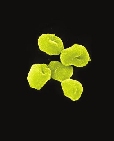
![4 The Scientific World Journal (a) (b) Figure 2: The external and inner surfaces of Ruditapes bruguieri shell. is high, 7.29 8.14 m L 1 [16, 17]. The chlorophyll concentration ranges from 0.71 to 1.](/docs-images/94/120859781/images/4-0.jpg "71 mg L 1 (mean ± SE, 1.11 ± 0.2 mg L 1 ). The concentrations of nitrate, phosphate, and silicate are 0.029 0.206 mg L 1 (0.101 ± 0.03 mg L 1 ), 0.001 0.027 mg L 1 (0.007 ± 0.004 mg L 1 ), and 0.")
![024 0.682 mg L 1 (0.454 ± 0.2 mg L 1 ), respectively [16, 17]. This can be sign that R.](/docs-images/94/120859781/images/4-1.jpg "bruguieri prefers habitats with good water aeration, stable oceanic water salinity, and high oxygen concentration. 3.1.3. Water Temperature. All the samples of R.")
4 4 The Scientific World Journal (a) (b) Figure 2: The external and inner surfaces of Ruditapes bruguieri shell. is high, m L 1 [16, 17]. The chlorophyll concentration ranges from 0.71 to 1.71 mg L 1 (mean ± SE, 1.11 ± 0.2 mg L 1 ). The concentrations of nitrate, phosphate, and silicate are mg L 1 (0.101 ± 0.03 mg L 1 ), mg L 1 (0.007 ± mg L 1 ), and mg L 1 (0.454 ± 0.2 mg L 1 ), respectively [16, 17]. This can be sign that R. bruguieri prefers habitats with good water aeration, stable oceanic water salinity, and high oxygen concentration Water Temperature. All the samples of R. bruguieri from the coasts of Jeju Island, collected by the author and other researchers, were not large in number. This is an evidence of sparseness of the R. bruguieri populations in these waters. This is typical for populations inhabiting marginal areas of the species range. Jeju Island is situated at the northern boundary of R. bruguieri range. In cases like this, it is just the winter water temperature that restricts vital functions of animal and determines the lower threshold of temperature favorable for the species. The minimum temperature, C, is observed in January and February along the coasts of Jeju Island [2, 4, 12]. Therefore, a water temperature of about C is close to the lower limit of favorable temperatures for R. bruguieri. In summer, the water temperature at the coasts of the Island is about of Cwiththemaximumin August [2, 4, 12]. At the southern coast of the island, surface water temperature varies from 14.5 CinMarchto29.5 Cin August; at the depth of 20 m, the water temperature ranges from 14.2 CinMarchto27.2 C in September [16, 17]. Thus, the annual fluctuations of the water temperature from C to C can be considered close to the temperature range, within which the studied bivalve species can exist Growth Rates and Relationships between Morphometric Parameters. The mean value of the ratio of shell length (L, mm) to shell height (H, mm) was 1.47 ± 0.00, whichmeans that shell is elongated. This ratio was not found to vary with age; that is, the shape of shell does not change as mollusk grows, and the shell proportions remain almost constant during its lifecycle: L H = L , R = , N = 154. (1) The regression describing the relationships between the length, height, and width (D, mm) of R. bruguieri shells revealed that these parameters correlate positively at a high degree of confidence: L = H , R = 0.98, N = 154, H = L , R = 0.98, N = 154, D = L , R = 0.96, N = 77. It is known that Manila clam R. philippinarum, which is closely related to R. bruguieri, forms annual winter rings on the outer surface of its shell[18]. Shells of R. bruguieri have rings similar to those of R. philippinarum (Figure 2). It is logical to suppose that R. bruguieri also forms growth ring during the cold winter period, taking into account that Jeju Island is situated near the northern boundary of R. bruguieri range and retardation in its shell growth is most probable just in winter. Moreover, it is known that warm-water bivalves, which usually form annual rings on their shells during the hottest period of the year in the middle and southern portions of their natural habitat, form annual rings in the coldest period at the northern boundary of their range, for example, Anadara (Scapharca) broughtoni [19]. In late October, two clams with remains of soft tissues were found; that is, they haddiedshortlybefore.neartheshelledge,eachspecimen hadalmostcompleteannualincrement(fromthelastring to the shell edge). New shell ring at the shell edge was not formed.therefore,thenumberofringsontheoutersurface of R. bruguieri shell was used in this work to estimate age of mollusks, and the distance from shell apex to each ring was measured to determine their growth rates retrospectively. R. bruguieri formed broad annual shell increments, especially during the first three years of life, that enabled to (2)
5 The Scientific World Journal 5 Frequency (ind.) Age (years) Figure 3: Age distribution of the Ruditapes bruguieri sample from the eastern coast of Jeju Island. Frequency (ind.) Shell length (mm) Figure 4: Distribution of shell lengths in the Ruditapes bruguieri sample from the eastern coast of Jeju Island. Arrows indicate the shelllengthsofclamswith1,2,3,4,5,and6annualwinterrings, respectively. determine the season when a mollusk died by the structure near the shell edge. Thus, the season of death was determined for each individual. Formed winter rings at the edges were found in 83.8% of shells. This indicates that the main portion of individuals perished during the coldest period of the year. Only 11.7% of individuals died during summer and 4.5% during the other seasons. This is the expected result for such tropical-subtropical species as R. bruguieri inhabiting the coastal waters of Jeju Island, which are near the northern boundary of the range of this mollusk species. The obtained data on growth of R. bruguieri showed a high variability of this process in the studied area (Table 1). It is partly explained by the interannual fluctuations of environmental parameters, as the specimens were from different age cohorts. As a rule, scattering of the morphometric indicesismorethanusualfororganismsinhabitingareas near boundaries of their species range, where one or several environmental parameters are close to the threshold values for the species tolerance and especially affect its growth rate. A Student s t-test did not reveal significant differences (at a level of 99%) among mean shell heights for scallops of the same age at different sites. At a level of 95%, the differences were revealed between the shell heights of the clams collected from the northwestern and southern coasts (shells with 4 and 5 annual rings), clams sampled from the northwestern and eastern coasts (shells with 4 and 5 annual rings), and clams sampled from the northern and eastern coasts (shells with 3 annualrings).itisknownthattheseawateratthesouthern coastofjejuislandiswarmerthantheoneatthenorthern coastduetothewarmtsushimacurrentflowingfromthe southwest [4]. Most likely, this is the reason of higher clam growthratesatthesouththanatthenorth(table1). The R. bruguieri samples from the coasts of Jeju Island included individuals at years of age. The maximum age of R. bruguieri was 6.5 years. At the eastern coast of Jeju Island, the age of mollusks in the sample varied within years, mostly years (34%) (Figure 3). Length, height, and width ranges of R. bruguieri shells sampledalongthejejuislandcoastswere mm(mean value 23.6 ± 0.4 mm), mm (16.2 ± 0.3 mm), and mm (9.0 ± 0.2 mm), respectively. At the eastern coast of Jeju Island, the sample consisted of individuals with the shell length of mm, mainly mm (75%) (Figure 4). The peaks in the histogram of shell length distribution corresponded to the values of shell length of individuals with 2, 3, and 4 annual rings (indicated by arrows in Figure 4); the heights of these peaks correlated with the heights of the peaks in the histogram of age distribution. The peaksfor5-and6-year-oldindividualsdidnotstandout, as the difference between values of the shell lengths of 5- and 6-year olds was small. These findings were an additional evidence of the annual periodicity of shell ring formation. 4. Conclusion Thus, the obtained data can be sign for a conclusion that R. bruguieri prefers coarse- and middle-grained sand and gravel with a slight admixture of silt. At the study area, this bivalve inhabits the sites with good water aeration, stable oceanic water salinity, , and a high oxygen concentration, mg L 1. As the winter water temperature is about CnearJejuIsland,atnorthernboundaryofR. bruguieri range, it indicates that this water temperature is close to the lower limit of favorable temperature for this mollusk. The maximum summer water temperature at the Island is about of C. Along the coasts of Jeju Island, South Korea, which is near the boundary of the species range, 83.8% of all individuals die during the coldest period of the year. Here, annual rings are formed on R. bruguieri shells during the winter. Near the boundary of the species range, the maximum age of R. bruguieri, determined during the study,is6.5years,buttheclamsamplesmainlyconsistof year-old individuals (34%). The maximum dimensions of clams are mm (length height of shell). At the study area, a usual shell length is mm (75% of all individuals). Conflict of Interests The author declares that there is no conflict of interests regarding the publication of this paper.
6 6 The Scientific World Journal Acknowledgments TheauthorisgratefultoDr.K.A.Lutaenko(IMBFEB RAS) for providing the shells of R. bruguieri and Dr. Ju. A. Trebukhova (IMB FEB RAS) for her help in composing the map. The work was supported in part by the Far Eastern Branch of the Russian Academy of Sciences (Project no. 12- I-DBS-09). References [1] P. M. Mikkelsen, R. Bieler, I. Kappner, and T. A. Rawlings, Phylogeny of Veneroidea (Mollusca: Bivalvia) based on morphology and molecules, Zoological Journal of the Linnean Society,vol.148,no.3,pp ,2006. [2] R.G.Noseworthy,N.R.Lim,andK.S.Choi, Acatalogueofthe mollusks of the Jeju Island, South Korea, The Korean Journal of Malacology, vol. 23, pp , [3] K. Vargas, Y. Asakura, M. Ikeda et al., Allozyme variation of littleneck clam Ruditapes philippinarum and genetic mixture analysis of foreign clams in Ariake Sea and Shiranui Sea off Kyushu Island, Japan, Fisheries Science, vol.74,no.3,pp , [4] R.G.NoseworthyandK.S.Choi, Thediversityandecology of mollusks in Seogundo off the southern Jeju Island, Republic of Korea, The Korean Journal of Malacology, vol. 26, pp , [5] K.A.LutaenkoandR.G.Noseworthy,Catalogue of the Living Bivalvia of the Continental Coast of the Sea of Japan (East Sea), Dalnauka, Vladivostok, Russia, [6] K. Lamprell and T. Whitehead, Bivalves of Australia, vol. 1, Crawford House Press, Bathurst, New South Wales, Australia, [7] S. Higo, P. Callomon, and Y. Goto, Catalogue and Bibliography of the Marine Shell-Bearing Mollusca of Japan, Elle Scientific Publications,Osaka,Japan,1999. [8] N. V. Subba Rao and A. Dey, Catalogue of marine molluscs of Andaman and Nicobar Islands, Records of the Zoological Survey of India, Occasional Paper,vol.187,pp.1 323,2000. [9] P. Valentich-Scott, A taxonomic, distributional and bibliographic checklist on Hong Kong marine bivalve molluscs and research published on them from , in Perspectives on Marine Environmental Change in Hong Kong and Southern China, Proceedings of an International Workshop Reunion Conference, 2001, B.Morton,Ed.,pp ,Hong Kong University Press, [10] M. Huber, Compendium of Bivalves. A Full-Color Guide to 3,300 of the World s Marine Bivalves. A Status on Bivalvia after 250 Years of Research, ConchBooks, Hackenheim, Germany, [11] A. V. Silina, A comparative study of samples of the bivalve Ruditapes philippinarum (Adams et Reeve, 1850) from populations and shell assemblages, RussianJournalofMarineBiology, vol. 37, no. 3, pp , [12] J. J. Lee and J. M. Hyan, Biological studies of the eastern coastal area in Cheju Island. Seasonal changes of macroinvertebrate community on the intertidal rocky shores, The Korean Journal of Malacology,vol.2,pp.1 20,1992. [13] J. J. Lee and J. C. Kim, Biological study of the western coastal area in Cheju Island. Distribution and seasonal community changes of the benthic macroinvertebrate on the rocky intertidal zone of Biyangdo, The Korean Journal of Malacology,vol. 9, pp , [14] A. V. Silina, Population characteristics of the bivalve Ruditapes philippinarum from Cheju Island coasts, Korea, The Korean Journal of Malacology,vol.26,pp ,2010. [15] O.N.PavlyukandY.A.Trebukhova, Intertidalmeiofaunaof Jeju Island, Korea, Ocean Science Journal, vol. 46, no. 1, pp. 1 11, [16]J.C.Ko,H.J.Ko,andM.H.Yang, Characteristicsofocean environmental factors and community structure of macrobenthos around Munseom, Jeju Island, Korea, The Korean Journal of Malacology,vol.24,pp ,2008. [17] J.C.Ko,H.J.Ko,B.Y.Kim,H.K.Cha,andD.S.Chang, Distribution characteristic of exploitable macrobenthic invertebrates of beach sediments in the southern coastal water of Jeju Island, The Korean Journal of Malacology,vol.28,pp ,2012. [18]A.V.SilinaandA.M.Popov, Studyoflineargrowthofthe bivalve Ruditapes philippinarum from Peter the Great Bay (the SeaofJapan)onthebasisofitsshellstructure, Biologiya Morya- Marine Biology,vol.15,no.4,pp.49 55,1989. [19] A. B. Olifirenko, Shell inner structure, recording elements and express-method for dating the age of Anadara broughtoni (Bivalvia, Arcidae), Izvestiya TINRO,vol.148,pp.57 68,2007.


7 Peptides BioMed Advances in Stem Cells International Virolog y Genomics Journal of Nucleic Acids Zoology Submit your manuscripts at The Scientific World Journal Journal of Signal Transduction Genetics Anatomy Enzyme Research Archaea Biochemistry Microbiology Evolutionary Biology Molecular Biology International Advances in Bioinformatics Journal of Marine Biology
South, Southeast, and East Asia. Physical Geography
 South, Southeast, and East Asia Physical Geography Mountains v Mountains are important in Asia because they influence: A. Population patterns B. Movement of people and goods C. Climate Mountains v The
Hiromi Nishida. 1. Introduction. 2. Materials and Methods
 Evolutionary Biology Volume 212, Article ID 342482, 5 pages doi:1.1155/212/342482 Research Article Comparative Analyses of Base Compositions, DNA Sizes, and Dinucleotide Frequency Profiles in Archaeal
ARE YOU READY TO THINK? Look at the first slide THINK PAIR SHARE!
 ARE YOU READY TO THINK? Look at the first slide THINK PAIR SHARE! WHAT PROMINENT FEATURE CAN YOU IDENTIFY IN THIS PICTURE? What do you think the different colors represent? Who might find such a picture
The Marine Environment
 The Marine Environment SECTION 16.1 Shoreline Features In your textbook, read about erosional landforms, beaches, estuaries, longshore currents, and rip currents. For each statement below, write or. 1.
Our climate system is based on the location of hot and cold air mass regions and the atmospheric circulation created by trade winds and westerlies.
 CLIMATE REGIONS Have you ever wondered why one area of the world is a desert, another a grassland, and another a rainforest? Or have you wondered why are there different types of forests and deserts with
The mechanisms influencing the timing, success and failure of spawning in natural populations of the sea urchin Strongylocentrotus intermedius
 The mechanisms influencing the timing, success and failure of spawning in natural populations of the sea urchin Strongylocentrotus intermedius in the northwestern Sea of Japan P. M. Zhadan 1, M. A. Vaschenko
The surface of the ocean floor is as varied as the land. The five major oceans, from largest to smallest, are
 11.1 Ocean Basins The surface of the ocean floor is as varied as the land. The five major oceans, from largest to smallest, are w the Pacific w the Atlantic w the Indian w the Southern w the Arctic The
1. Oceans. Example 2. oxygen.
 1. Oceans a) Basic facts: There are five oceans on earth, making up about 72% of the planet s surface and holding 97% of the hydrosphere. Oceans supply the planet with most of its oxygen, play a vital
Practice Questions: Plate Tectonics
 Practice Questions: Plate Tectonics 1. Base your answer to the following question on The block diagram below shows the boundary between two tectonic plates. Which type of plate boundary is shown? A) divergent
Long-Term Trend of Summer Rainfall at Selected Stations in the Republic of Korea
 Long-Term Trend of Summer Rainfall at Selected Stations in the Republic of Korea Il-Kon Kim Professor, Department of Region Information Rafique Ahmed Professor, Geography and Earth Science Silla University
The Marine Environment
 The Marine Environment SECTION 16.1 Shoreline Features In your textbook, read about erosional landforms, beaches, estuaries, longshore currents, and rip currents. For each statement below, write true or
Which graph best shows the relationship between intensity of insolation and position on the Earth's surface? A) B) C) D)
 B) C) D)") 1. The hottest climates on Earth are located near the Equator because this region A) is usually closest to the Sun B) reflects the greatest amount of insolation C) receives the most hours of daylight D)
1. The hottest climates on Earth are located near the Equator because this region A) is usually closest to the Sun B) reflects the greatest amount of insolation C) receives the most hours of daylight D)
Significant Ecological Marine Area Assessment Sheet
 Significant Ecological arine Area Assessment Sheet Name: Eastern Bay of Island Biogenic Soft Sediment Complex Summary: The semi-sheltered areas between the central islands of the Eastern Bay of Islands
KUALA LUMPUR MONSOON ACTIVITY CENT
 T KUALA LUMPUR MONSOON ACTIVITY CENT 2 ALAYSIAN METEOROLOGICAL http://www.met.gov.my DEPARTMENT MINISTRY OF SCIENCE. TECHNOLOGY AND INNOVATIO Introduction Atmospheric and oceanic conditions over the tropical
Tropical Moist Rainforest
 Tropical or Lowlatitude Climates: Controlled by equatorial tropical air masses Tropical Moist Rainforest Rainfall is heavy in all months - more than 250 cm. (100 in.). Common temperatures of 27 C (80 F)
Ocean Boundary Currents Guiding Question: How do western boundary currents influence climate and ocean productivity?
 Name: Date: TEACHER VERSION: Suggested Student Responses Included Ocean Boundary Currents Guiding Question: How do western boundary currents influence climate and ocean productivity? Introduction The circulation
THE DEPOSITS OF TSUNAMIS WESLEY PESANTEZ, CATHERINE NIELD, COLIN WINTER
 THE DEPOSITS OF TSUNAMIS WESLEY PESANTEZ, CATHERINE NIELD, COLIN WINTER AN OVERVIEW OF OUR SEMINAR WHAT IS A TSUNAMI WHY STUDY TSUNAMIS PROPERTIES OF TSUNAMIS TSUNAMI HYDRODYNAMICS IDEALIZED DEPOSITS SEDIMENT
Lab 7: Sedimentary Structures
 Name: Lab 7: Sedimentary Structures Sedimentary rocks account for a negligibly small fraction of Earth s mass, yet they are commonly encountered because the processes that form them are ubiquitous in the
Weather & Ocean Currents
 Weather & Ocean Currents Earth is heated unevenly Causes: Earth is round Earth is tilted on an axis Earth s orbit is eliptical Effects: Convection = vertical circular currents caused by temperature differences
Marine Ecoregions. Marine Ecoregions. Slide 1. Robert G. Bailey. USDA Forest Service Rocky Mountain Research Station
 Slide 1 Marine Ecoregions Robert G. Bailey Marine Ecoregions Robert G. Bailey USDA Forest Service Rocky Mountain Research Station rgbailey@fs.fed.us Draft of 7/20/2006 8:44 PM Abstract: Oceans occupy some
UNIT 5: ECOLOGY Chapter 15: The Biosphere
 CORNELL NOTES Directions: You must create a minimum of 5 questions in this column per page (average). Use these to study your notes and prepare for tests and quizzes. Notes will be stamped after each assigned
Mediterranean Climates (Csa, Csb)
") Climatic Zones & Types Part II I've lived in good climate, and it bores the hell out of me. I like weather rather than climate. 1 John Steinbeck Mediterranean Climates (Csa, Csb) Main locations Western
Climatic Zones & Types Part II I've lived in good climate, and it bores the hell out of me. I like weather rather than climate. 1 John Steinbeck Mediterranean Climates (Csa, Csb) Main locations Western
 Page 1 of 5 Home research global climate enso effects Research Effects of El Niño on world weather Precipitation Temperature Tropical Cyclones El Niño affects the weather in large parts of the world. The
The Sea Floor. Chapter 2
 The Sea Floor Chapter 2 Geography of the Ocean Basins World ocean is the predominant feature on the Earth in total area Northern Hemisphere = 61% of the total area is ocean. Southern Hemisphere = about
Lecture Outlines PowerPoint. Chapter 13 Earth Science 11e Tarbuck/Lutgens
 Lecture Outlines PowerPoint Chapter 13 Earth Science 11e Tarbuck/Lutgens 2006 Pearson Prentice Hall This work is protected by United States copyright laws and is provided solely for the use of instructors
Name: Date: Hour: Comparing the Effects of El Nino & La Nina on the Midwest (E4.2c)
") Purpose: Comparing the Effects of El Nino & La Nina on the Midwest (E4.2c) To compare the effects of El Nino and La Nina on the Midwest United States. Background Knowledge: The El Nino-Southern Oscillation
Purpose: Comparing the Effects of El Nino & La Nina on the Midwest (E4.2c) To compare the effects of El Nino and La Nina on the Midwest United States. Background Knowledge: The El Nino-Southern Oscillation
Unit 4 - Water. Earth s Interior. Earth s Interior. Continental Drift. Continental Drift. Continental Drift. Crust. Mantle. Core.
 Unit 4 - Water How did the oceans form? What special adaptations do saltwater organisms have? Where does our water come from? How do humans affect the Earth s water? Crust Rigid outer shell of Earth Oceanic
Climate Outlook for March August 2018
 The APEC CLIMATE CENTER Climate Outlook for March August 2018 BUSAN, 26 February 2018 The synthesis of the latest model forecasts for March to August 2018 (MAMJJA) from the APEC Climate Center (APCC),
6. What has been the most effective erosive agent in the climate system? a. Water b. Ice c. Wind
 Multiple Choice. 1. Heinrich Events a. Show increased abundance of warm-water species of planktic foraminifera b. Show greater intensity since the last deglaciation c. Show increased accumulation of ice-rafted
Chapter 21 Southwest Asia: Harsh & Arid Lands
 Name Hour Chapter 21 Southwest Asia: Harsh & Arid Lands Essential Question: How has the physical geography of Asia influenced the development of these regions (i.e. history, population distribution, &
Thursday, April 27, 17
 Thursday, April 27, 17 Geography of Southeast Asia Objec-ve: Understand the geographical differences between the mainland region and the insular region of Southeast Asia. Do Now: What is the capital of
Hydrography and biological resources in the western Bering Sea. Gennady V. Khen, Eugeny O. Basyuk. Pacific Research Fisheries Centre (TINRO-Centre)
") Hydrography and biological resources in the western Bering Sea Gennady V. Khen, Eugeny O. Basyuk Pacific Research Fisheries Centre (TINRO-Centre) Bering Sea: deep-sea basin, shelf, and US-Russia convention
Hydrography and biological resources in the western Bering Sea Gennady V. Khen, Eugeny O. Basyuk Pacific Research Fisheries Centre (TINRO-Centre) Bering Sea: deep-sea basin, shelf, and US-Russia convention
1. Name at least one place that the mid-atlantic Ridge is exposed above sea level.
 Interpreting Tectonic and Bathymetric Maps. The purpose of this lab is to provide experience interpreting the bathymetry of the seafloor in terms of tectonic and geologic settings and processes. Use the
Oceanography is the scientific study of oceans Oceans make up over 70% of the Earth s surface
 Oceanography Oceanography is the scientific study of oceans Oceans make up over 70% of the Earth s surface An ocean must be large and have features which set it apart from other oceans (currents, water
Long-term Change of Ocean Productivity: A case study in the Bay of Bengal
 Long-term Change of Ocean Productivity: A case study in the Bay of Bengal The 3 rd Asian /12 th Korean-Japan Workshop on Ocean Color Dr.Md.Latifur Rahman Sarker, UTM, Malaysia & RU, Bangladesh & Noor Saadah
ENSO: Recent Evolution, Current Status and Predictions. Update prepared by: Climate Prediction Center / NCEP 9 November 2015
 ENSO: Recent Evolution, Current Status and Predictions Update prepared by: Climate Prediction Center / NCEP 9 November 2015 Outline Summary Recent Evolution and Current Conditions Oceanic Niño Index (ONI)
Brief report on Belize carbonate environments field trip Feb. 2012
 Brief report on Belize carbonate environments field trip Feb. 2012 In february 2012 I travelled to San Pedro (Ambergris Caye) Belize (Figure 1) to examine and study depositional environments of carbonate
Students will work in small groups to collect detailed data about a variety of living things in the study area.
 TEACHER BOOKLET Sampling along a transect Name BIOLOGY Students will work in small groups to collect detailed data about a variety of living things in the study area. Students will need: 10 metre long
Climate Outlook for December 2015 May 2016
 The APEC CLIMATE CENTER Climate Outlook for December 2015 May 2016 BUSAN, 25 November 2015 Synthesis of the latest model forecasts for December 2015 to May 2016 (DJFMAM) at the APEC Climate Center (APCC),
Chapter 3 Section 3 World Climate Regions In-Depth Resources: Unit 1
 Guided Reading A. Determining Cause and Effect Use the organizer below to show the two most important causes of climate. 1. 2. Climate B. Making Comparisons Use the chart below to compare the different
World Geography Chapter 3
 World Geography Chapter 3 Section 1 A. Introduction a. Weather b. Climate c. Both weather and climate are influenced by i. direct sunlight. ii. iii. iv. the features of the earth s surface. B. The Greenhouse
UPDATE OF REGIONAL WEATHER AND SMOKE HAZE (September 2017)
") UPDATE OF REGIONAL WEATHER AND SMOKE HAZE (September 2017) 1. Review of Regional Weather Conditions in August 2017 1.1 Southwest Monsoon conditions continued to prevail in the region in August 2017. The
UPDATE OF REGIONAL WEATHER AND SMOKE HAZE (September 2017) 1. Review of Regional Weather Conditions in August 2017 1.1 Southwest Monsoon conditions continued to prevail in the region in August 2017. The
Lecture Outline Wednesday - Friday February 14-16, 2018
 Lecture Outline Wednesday - Friday February 14-16, 2018 Quiz 2 scheduled for Friday Feb 23 (Interlude B, Chapters 6,7) Questions? Chapter 6 Pages of the Past: Sedimentary Rocks Key Points for today Be
Chapter 1 Section 2. Land, Water, and Climate
 Chapter 1 Section 2 Land, Water, and Climate Vocabulary 1. Landforms- natural features of the Earth s land surface 2. Elevation- height above sea level 3. Relief- changes in height 4. Core- most inner
A BEACH IS A BEACH. Or Is It? Hawaii. St. Croix, US Virgin Islands
 A BEACH IS A BEACH Or Is It? Pt. Reyes, California Western Florida Hawaii AGI What is a beach? Eastern Maine A beach is a strip of shoreline washed by waves and tides. Crane Key, Florida Bay St. Croix,
The Ocean Floor Chapter 14. Essentials of Geology, 8e. Stan Hatfield and Ken Pinzke Southwestern Illinois College
 The Ocean Floor Chapter 14 Essentials of Geology, 8e Stan Hatfield and Ken Pinzke Southwestern Illinois College The vast world ocean Earth is often referred to as the water planet 71% of Earth s surface
12. The diagram below shows the collision of an oceanic plate and a continental plate.
 Review 1. Base your answer to the following question on the cross section below, which shows the boundary between two lithospheric plates. Point X is a location in the continental lithosphere. The depth
Geol 117 Lecture 18 Beaches & Coastlines. I. Types of Coastlines A. Definition:
 I. Types of Coastlines A. Definition: 1. Shore = narrow zone where ocean meets land (e.g. beach) 2. Coast is a broad area where both ocean and land processes act a. Includes onshore marshes, dunes, sea
Chapter 6, Part Colonizers arriving in North America found extremely landscapes. It looked different to region showing great.
 Social Studies 9 Unit 1 Worksheet Chapter 6, Part 1. 1. Colonizers arriving in North America found extremely landscapes. It looked different to region showing great. 2. The Earth is years old and is composed
Marine Sediments EPSS15 Spring 2017 Lab 4
 Marine Sediments EPSS15 Spring 2017 Lab 4 Why Sediments? Record of Earth s history - Tectonic plate movement - Past changes in climate - Ancient ocean circulation currents - Cataclysmic events 1 Classification
The Coast: Beaches and Shoreline Processes
 1 2 3 4 5 6 7 8 9 The Coast: es and Shoreline Processes Trujillo & Thurman, Chapter 10 Oceanography 101 Chapter Objectives Recognize the various landforms characteristic of beaches and coastal regions.
Exxon Valdez Oil Spill Restoration Project Annual Report
 Exxon Valdez Oil Spill Restoration Project Annual Report Ecology and Demographics of Pacific Sand Lance, Ammodytes hexapterus Pallas, in Lower Cook Inlet, Alaska Restoration Project 99306 Final Report
Crustal Activity. Plate Tectonics - Plates - Lithosphere - Asthenosphere - Earth s surface consists of a major plates and some minor ones
 Name: Date: Period: Tectonics The Physical Setting: Earth Science CLASS NOTES Tectonics - s - Lithosphere - Asthenosphere - Earth s surface consists of a major plates and some minor ones The plates are
The Coast: Beaches and Shoreline Processes Trujillo & Thurman, Chapter 10
 The Coast: es and Shoreline Processes Trujillo & Thurman, Chapter 10 Oceanography 101 Chapter Objectives Recognize the various landforms characteristic of beaches and coastal regions. Identify seasonal
Climate Outlook for October 2017 March 2018
 The APEC CLIMATE CENTER Climate Outlook for October 2017 March 2018 BUSAN, 25 September 2017 The synthesis of the latest model forecasts for October 2017 to March 2018 (ONDJFM) from the APEC Climate Center
60% water. Big Bang: 14,000 millions years ago The Earth originated about 4,500 millions years ago its orbit allows water to exist in a liquid state!
 Ch2. The Sea Floor #1 Why geology of the oceans? Marine habitats are directly shaped by geological processes The form of the coastlines The depth of the water Type of bottom (muddy, sandy, rocky) #2 Geological
Forecast of Nearshore Wave Parameters Using MIKE-21 Spectral Wave Model
 Forecast of Nearshore Wave Parameters Using MIKE-21 Spectral Wave Model Felix Jose 1 and Gregory W. Stone 2 1 Coastal Studies Institute, Louisiana State University, Baton Rouge, LA 70803 2 Coastal Studies
Synchronicity of climate driven regime shifts among the East Asian Marginal Sea waters and major fish species
 Synchronicity of climate driven regime shifts among the East Asian Marginal Sea waters and major fish species SM Mustafizur Rahman 1, Chung Il Lee 2 1 Research Institute for Dok-do and Ulleung-do, Kyungpook
Long Range Forecast Update for 2014 Southwest Monsoon Rainfall
 Earth System Science Organization (ESSO) Ministry of Earth Sciences (MoES) India Meteorological Department PRESS RELEASE New Delhi, 9 June 2014 Long Update for 2014 Southwest Monsoon Rainfall HIGHLIGHTS
Biosphere. All living things, plants, animals, (even you!) are part of the zone of the earth called the biosphere.
 are part of the zone of the earth called the biosphere.") Unit 1 Study Guide Earth s Spheres Biosphere All living things, plants, animals, (even you!) are part of the zone of the earth called the biosphere. Hydrosphere Water covers ¾ of the earth, made up mostly
Unit 1 Study Guide Earth s Spheres Biosphere All living things, plants, animals, (even you!) are part of the zone of the earth called the biosphere. Hydrosphere Water covers ¾ of the earth, made up mostly
Paleo Lab #4 - Sedimentary Environments
 Paleo Lab #4 - Sedimentary Environments page - 1. CHARACTERISTICS OF SEDIMENT Grain size and grain shape: The sizes and shapes of sedimentary particles (grains) are modified considerably during their transportation
A) B) C) D) 4. Which diagram below best represents the pattern of magnetic orientation in the seafloor on the west (left) side of the ocean ridge?
 B) C) D) 4. Which diagram below best represents the pattern of magnetic orientation in the seafloor on the west (left) side of the ocean ridge?") 1. Crustal formation, which may cause the widening of an ocean, is most likely occurring at the boundary between the A) African Plate and the Eurasian Plate B) Pacific Plate and the Philippine Plate C)
1. Crustal formation, which may cause the widening of an ocean, is most likely occurring at the boundary between the A) African Plate and the Eurasian Plate B) Pacific Plate and the Philippine Plate C)
Oceanographic Conditions in the Gulf of St. Lawrence during 1999
 Fisheries and Oceans Science Pêches et Océans Sciences DFO Science Laurentian Region Stock Status Report G4-01 (2000) Researh vessel CCGS Martha L. Black Oceanographic Conditions in the Gulf of St. Lawrence
Complete the following: a. Lines of latitude are parallel to the equator. Name:
 Name: Date: Social Studies Introduction: Basic Geography Period: Latitude Latitude is defined as a measurement of distance in degrees north and south of the equator. The word latitude is derived from the
Climate/Ocean dynamics
 Interannual variations of the East-Kamchatka and East-Sakhalin Currents volume transports and their impact on the temperature and chemical parameters in the Okhotsk Sea Andrey G. Andreev V.I. Il ichev
Tezula funebralis Shell height variance in the Intertidal zones
 Laci Uyesono Structural Comparison Adaptations of Marine Animals Tezula funebralis Shell height variance in the Intertidal zones Introduction The Pacific Coast of the United States is home to a great diversity
Depositional Environment
 Depositional Environment Sedimentary depositional environment describes the combination of physical, chemical and biological processes associated with the deposition of a particular type of sediment. Types
STUDY AREA AND METHODOLOGY
 . CHAPTER 2 STUDY AREA AND METHODOLOGY 26 CHAPTER 2 STUDY AREA AND METHODOLOGY Kundalika is a major river in konkan region of Maharashtra. River originates in Western Ghats at an altitude of 820 m ASL
Climatic Conditions Around Greenland 1993
 NFO Sci. Coun. Studies, 22: 43 49 Climatic Conditions round Greenland 1993 M. Stein Institut für Seefischerei, Palmaille 9, D 22767 Hamburg Federal Republic of Germany bstract ir temperature anomalies
Chapter 02 The Sea Floor
 Chapter 02 The Sea Floor Multiple Choice Questions 1. One of the following is not one of the world's major ocean basins: A. Atlantic Ocean B. Arctic Ocean C. Indian Ocean D. Antarctic Ocean E. Pacific
Project 1.3.1: Improved knowledge of biota, habitats and risks. Project Leader: Dr Mick Haywood, CSIRO Division of Marine and Atmospheric Research
 Marine and Tropical Sciences Research Facility (MTSRF) June 2007 Milestone Report Project 1.3.1: Improved knowledge of biota, habitats and risks Project Leader: Dr Mick Haywood, CSIRO Division of Marine
09 November 2017 (Week ) NEW BRITISH ADMIRALTY PUBLICATIONS AVAILABLE NOW
 NEW BRITISH ADMIRALTY PUBLICATIONS AVAILABLE NOW") 09 November 2017 (Week 45 2017) NEW BRITISH ADMIRALTY PUBLICATIONS AVAILABLE NOW CODE TITLE AVAILABLE PRICE GBP NP057B Norway Pilot Volume 2B, 10th Edition, 2017 WK 45/17 60.60 NP207-18 ADMIRALTY Tide
09 November 2017 (Week 45 2017) NEW BRITISH ADMIRALTY PUBLICATIONS AVAILABLE NOW CODE TITLE AVAILABLE PRICE GBP NP057B Norway Pilot Volume 2B, 10th Edition, 2017 WK 45/17 60.60 NP207-18 ADMIRALTY Tide
Australia and New Zealand: Powerpoint
 Australia and New Zealand: Powerpoint Physical Geography Australia and New Zealand are between the Indian and Pacific Oceans. Australia s seasons are opposite of the United States due to their location.
Weather and Climate Summary and Forecast Summer 2017
 Weather and Climate Summary and Forecast Summer 2017 Gregory V. Jones Southern Oregon University August 4, 2017 July largely held true to forecast, although it ended with the start of one of the most extreme
Short Communication Length-weight relationship of black sea urchin (Stomopneustes variolaris) in Sri Lanka
 in Sri Lanka") Int. J. Aquat. Biol. (2017) 5(6): 408-412 DOI: ISSN: 2322-5270; P-ISSN: 2383-0956 Journal homepage: www.ij-aquaticbiology.com 2017 Iranian Society of Ichthyology Short Communication Length-weight relationship
Int. J. Aquat. Biol. (2017) 5(6): 408-412 DOI: ISSN: 2322-5270; P-ISSN: 2383-0956 Journal homepage: www.ij-aquaticbiology.com 2017 Iranian Society of Ichthyology Short Communication Length-weight relationship
Beach Recovery Processes in Urban Beach Systems : A Study in Hong Kong after an Extreme Storm Event
 Beach Recovery Processes in Urban Beach Systems : A Study in Hong Kong after an Extreme Storm Event LIFE+ FLANDRE international workshop "Management of coastal dunes and sandy beaches" Session 1. Climate
3. The diagram below shows how scientists think some of Earth's continents were joined together in the geologic past.
 1. The map below shows the present-day locations of South America and Africa. Remains of Mesosaurus, an extinct freshwater reptile, have been found in similarly aged bedrock formed from lake sediments
Small area of the ocean that is partially surrounded by land. The Ocean Basins. Three Major Oceans. Three Major Oceans. What is a SEA?
 The Ocean Basins How Deep is the Ocean? 1 2 Three Major Oceans Three Major Oceans Pacific Atlantic the shallowest ocean (3.3km average depth) Indian second shallowest ocean (3.8km average depth) Pacific
The Indian Ocean. Copyright 2010 LessonSnips
 The Indian Ocean One of the five major geographic divisions of the world s ocean, the Indian Ocean is located in the Eastern Hemisphere. The Indian Ocean is bounded by three continents: Africa to the west,
Geographical location and climatic condition of the
 Geographical location and climatic condition of the study sites North eastern region of India is comprised of eight states namely; Arunachal Pradesh, Assam, Manipur, Meghalaya, Mizoram, Nagaland, Sikkim
3. The map below shows an eastern portion of North America. Points A and B represent locations on the eastern shoreline.
 1. Most tornadoes in the Northern Hemisphere are best described as violently rotating columns of air surrounded by A) clockwise surface winds moving toward the columns B) clockwise surface winds moving
Long-term changes in microalgae communities on the Russian East coast with emphasis on toxic and bloom forming species
 Long-term changes in microalgae communities on the Russian East coast with emphasis on toxic and bloom forming species Tatiana Yu. Orlova, Polina A. Kameneva, Tatiana V. Morozova A.V. Zhirmunsky Institute
Adopt a Drifter Lesson Plan by Mary Cook, Middle School Science Teacher, Ahlf Jr. High School, Searcy, Arkansas
 Adopt a Drifter Lesson Plan by Mary Cook, Middle School Science Teacher, Ahlf Jr. High School, Searcy, Arkansas Do Ocean Surface Currents Influence Climate? Objectives Students will construct climographs
Form 4 of Schedule 5 of the Exclusive Economic Zone and Continental Shelf (Environmental Effects Permitted Activities) Regulations 2013
 Regulations 2013") FORM 4 Permitted activities: Post-activity report Form 4 of Schedule 5 of the Exclusive Economic Zone and Continental Shelf (Environmental Effects Permitted Activities) Regulations 2013 How to use this
FORM 4 Permitted activities: Post-activity report Form 4 of Schedule 5 of the Exclusive Economic Zone and Continental Shelf (Environmental Effects Permitted Activities) Regulations 2013 How to use this
Growth and Asexual Reproduction of the Starfish Nepanthia belcheri (Perrier)
") Growth and Asexual Reproduction of the Starfish Nepanthia belcheri (Perrier) RON KENNyl ABSTRACT: Nepanthia belcheri (Perrier) attains a longest arm radius of mm during the first growing period, 8 mm in
Growth and Asexual Reproduction of the Starfish Nepanthia belcheri (Perrier) RON KENNyl ABSTRACT: Nepanthia belcheri (Perrier) attains a longest arm radius of mm during the first growing period, 8 mm in
Ocean and Coastal Processes. Ocean Basins. Chapter 20. Ocean Basins and Plates. Ocean Terms. Sea Arch Bay-mouth Bar Spit Tombolo Coast.
 Chapter 20 Ocean Basins and Plates Ocean and Coastal Processes Tide Wave Height Length Period Base Refraction Tsunami Beach Sea stack Ocean Terms Sea Arch Bay-mouth Bar Spit Tombolo Coast Emergent Submergent
2013 ATLANTIC HURRICANE SEASON OUTLOOK. June RMS Cat Response
 2013 ATLANTIC HURRICANE SEASON OUTLOOK June 2013 - RMS Cat Response Season Outlook At the start of the 2013 Atlantic hurricane season, which officially runs from June 1 to November 30, seasonal forecasts
Project Retrograde imagine Earth rotated in the opposite direction
 Project Retrograde imagine Earth rotated in the opposite direction The rotation of Earth shapes our climate system in various ways: It controls the major wind directions, lets the weather systems swirl,
CHAPTER IV THE RELATIONSHIP BETWEEN OCEANOGRAPHY AND METEOROLOGY
 CHAPTER IV THE RELATIONSHIP BETWEEN OCEANOGRAPHY AND METEOROLOGY THE relationship between oceanography and meteorology is of an order different from that between it and geology or biology, because meteorologic
Environmental Science
 Environmental Science A Study of Interrelationships Cui Jiansheng Hebei University of Science and Technology CH06 Kinds of Ecosystems and Communities Chapter Objectives After reading this chapter, you
Polar Climate Zone. Temperate Climate Zone. Tropical Climate Zone. Temperate Climate Zone. Polar Climate Zone. 1st. 3 hottest cities 3 coldest cities
 Exploring the Influences on Climate Part 1: Predictions and Background 1.) Based on the map below, record what you predict to be the 3 hottest and coldest cities in the month of July. Polar Climate Zone
Chapter 17. Ocean and Coastal Processes
 Chapter 17 Ocean and Coastal Processes Ocean Basins and Plates Ocean Basins Ocean Basins are profoundly different from the continents. Ocean crust is thin and dense and young. New ocean crust is generated
Global Patterns Gaston, K.J Nature 405. Benefit Diversity. Threats to Biodiversity
 Biodiversity Definitions the variability among living organisms from all sources, including, 'inter alia', terrestrial, marine, and other aquatic ecosystems, and the ecological complexes of which they
Laboratory #7: Plate Tectonics
 Materials Needed: 1. Pencil 2. Colored Pencils 3. Metric/Standard Ruler 4. Calculator 5. Tracing Paper Laboratory #7: Plate Tectonics Plate Tectonics The Earth is composed of layers. At the center is a
Marine Ecology Pacing Guide
 Marine Ecology Pacing Guide Course Description: The focus of the course is the interrelationships among marine organisms and the physical, chemical, geological and biological factors. North Carolina coastal
CHAPTER 6 & 7 VOCABULARY
 CHAPTER 6 & 7 VOCABULARY 1. Biome 2. Climate 3. Latitude 4. Altitude 5. Emergent layer 6. Epiphyte 7. Understory 8. Permafrost 9. Wetland 10.Plankton 11.Nekton 12.Benthos 13.Littoral zone 14.Benthic zone
What creates a coral reef? Why are corals able to form huge reefs?
 Marine ecosystems 5: Coral Reefs Unique features The foundation of the ecosystem is produced by living things Reef-building corals Similarities with tropical rain forests Richness and complexity 3-dimensional
CORRELATION ANALYSIS BETWEEN PALAEMONETES SHRIMP AND VARIOUS ALGAL SPECIES IN ROCKY TIDE POOLS IN NEW ENGLAND
 CORRELATION ANALYSIS BETWEEN PALAEMONETES SHRIMP AND VARIOUS ALGAL SPECIES IN ROCKY TIDE POOLS IN NEW ENGLAND Douglas F., Department of Biology,, Worcester, MA 01610 USA (D@clarku.edu) Abstract Palamonetes
Weather and Climate Summary and Forecast August 2018 Report
 Weather and Climate Summary and Forecast August 2018 Report Gregory V. Jones Linfield College August 5, 2018 Summary: July 2018 will likely go down as one of the top five warmest July s on record for many
Verification of the Seasonal Forecast for the 2005/06 Winter
 Verification of the Seasonal Forecast for the 2005/06 Winter Shingo Yamada Tokyo Climate Center Japan Meteorological Agency 2006/11/02 7 th Joint Meeting on EAWM Contents 1. Verification of the Seasonal