Re-examination of geophysical data off Northwest India: Implications to the Late Cretaceous plate tectonics between India and Africa
|
|
|
- Branden Johns
- 5 years ago
- Views:
Transcription
1 Author version: Mar. Geol., vol.365; 2015; Re-examination of geophysical data off Northwest India: Implications to the Late Cretaceous plate tectonics between India and Africa M. V. Ramana 1, Maria Ana Desa*,2 and T. Ramprasad 2 1 Mauritius Oceanographic Institute, Victoria Avenue Mauritius 2 CSIR-National Institute of Oceanography, Dona Paula, Goa, India * Corresponding author, mdesa@nio.org Tel: Fax: ABSTRACT The Gop and Laxmi Basins lying off Northwest India have been assigned ambiguous crustal types and evolution mechanisms. The Chagos-Laccadive Ridge (CLR) complex lying along the southwest coast of India has been attributed different evolutionary processes. Late Cretaceous seafloor spreading between India and Africa formed the Mascarene Basin, and the plate reconstruction models depict unequal crustal accretion in this basin. Re-interpretation of magnetic data in the Gop and Laxmi Basins suggests that the underlying oceanic crust was accreted contemporaneously from 79 Ma at slow half spreading rates (0.6 to 1.5 cm/yr) separating the Seychelles-Laxmi Ridge complex from India. The spreading ridge became extinct at 71 Ma in the central region between N and E, and at 68.7 Ma in the Gop Basin. Extinction progressed southwards with time until 64.1 Ma at ~14.5 N in the Laxmi Basin. This spreading probably limited the seafloor spreading in the northern Mascarene Basin, while normal to fast spreading continued in the south. The fracture zone FZ2 acted as a major boundary between the northern and southern Mascarene Basin, and may have also restricted the southward propagation of the Laxmi Basin spreading ridge. Plate reconstruction models generated in this study accommodate several microplates between Madagascar and India, and trace their movements over time within the India-Africa spreading corridor. Furthermore, these models suggest the formation of the Seychelles-Laxmi Ridge microplate by 79 Ma in a complex three plate system. This microplate may have existed up to 64.1 Ma and experienced an anticlockwise rotation of about 50. Under the influence of the Deccan hotspot activity, the Laxmi Basin spreading ridge jumped southwestward splitting the Seychelles- Laxmi Ridge complex and initiating the Carlsberg Ridge. The presence of about 160 km of oceanic crust in the Gop and Laxmi Basins partially reduces the space problem faced in the earlier plate reconstruction models. Keywords: West coast of India, Mascarene Basin, Laxmi Ridge, Seychelles, plate reconstructions, magnetic anomalies, Gop Basin 1
2 1. Introduction The Western Continental Margin of India is characterized by i) a remarkably straight shelf edge limited by ~200 m isobath, ii) NW-SE trending continental shelf, ~300 km wide off Mumbai narrowing gradually southward to ~50 km off Cochin, iii) continental slope bounded between 200 and 2000 m isobaths, narrow in the north and wide towards south iv) deep sedimentary basins, and v) several structural features (Fig. 1). The shelf area is composed of four offshore basins, i.e. Kutch, Saurashtra, Bombay and Konkan Kerala (Fig. 2), characterized by horst-graben structures (Biswas, 1987). The major structural features include the midshelf high, Pratap Ridge complex (Naini, 1980; Subrahmanyam et al., 1995), aseismic Laxmi Ridge (Naini and Talwani, 1982) and the Chagos- Laccadive Ridge (CLR) System (Duncan, 1990). The deep-water sedimentary basins include the Western and Eastern Arabian Basins separated by the Laxmi and northern CLR Ridges. The extensions of the onshore structural lineaments such as the Precambrian Dharwarian trends into the Western Continental Margin of India have been delineated (Naini, 1980; Kolla and Coumes, 1990). The Narmada-Son lineament, an old Precambrian feature (Powar, 1981) was reactivated in the Late Cretaceous. During its initial marine sedimentation stage, regional uplift caused by Deccan volcanism abruptly ended its activity resulting in a failed rift (Biswas, 1988). The Western Arabian Basin is bounded to the west by the Owen Fracture Zone, to the south by the NW-SE trending active Carlsberg Ridge and, to the north and east by the Laxmi and CLR Ridges respectively (Fig. 1). The underlying basement is oceanic associated with oldest seafloor spreading magnetic anomalies decreasing in age from anomaly 28n in the north to 22 in the south (Mckenzie and Sclater, 1971; Naini and Talwani, 1982; Miles and Roest, 1993; Dyment, 1998; Chaubey et al., 2002a; Royer et al., 2002; Collier et al., 2008). The Eastern Arabian Basin lying between the eastern end of the Laxmi and northern CLR Ridges and the adjacent continental slope of India consists of the Laxmi and Laccadive Basins (Fig. 2). The Pratap Ridge composed of a chain of shallow basement highs along the western offshore has been related to Deccan-Reunion hotspot activity (Krishna et al., 1992), and rifting between India and Madagascar (Subrahmanyam et al., 1995). 2. Morpho-tectonic Features The approximately N-S trending CLR system is a positive topographic feature extending from about 10 S to 15 N (Fig. 1). The ridge consists of several irregular blocks separated by relatively deep east-west trending channels and a considerable length of its crest is composed of shoals, banks, coral reefs and atolls. The free-air gravity signature is positive (~25 mgal) when compared with that of the surrounding regions (Kahle and Talwani, 1973; Naini and Talwani, 1982). The origin of the CLR system is attributed to various processes such as transform faulting (McKenzie and Sclater, 1971), microcontinent tectonics (Avraham and Bunce, 1977) and hotspot volcanism (Dietz and 2
3 Holden, 1970; Whitmarsh, 1974). Based on crustal structure and lack of appreciable magnetic anomalies, Naini and Talwani (1982) and Gopala Rao et al. (1987) favored a continental origin for this ridge. DSDP and ODP drilling suggest that the Deccan Trap province on the Indian peninsula and the CLR system were formed by volcanic activity during the northward motion of the Indian plate over the Reunion hotspot (Duncan, 1990). The CLR system can be divided into the northern Laccadive Ridge, the middle Maldives block and southern Chagos Bank. The northern Laccadive Ridge is bounded by the offshore extensions of the onshore lineaments- Chapporo and Bhavani Shear zones (Fig. 2), and is associated with deep N-S to NW-SE Dharwarian trends (GSI, 2001; Nair et al., 2013). Different opinions prevail on the nature and origin of the Laccadive Ridge. It is considered as a continental sliver (Naini and Talwani (1982), alternately it is attributed to hotspot volcanism (Biswas, 1988). Chaubey et al. (2002b, 2008) suggested that the Laccadive Ridge is a thinned continental fragment intermingled with volcanic intrusives and locally compensated according to the Airy model of isostasy (Ajay et al., 2010). The NW-SE trending Laxmi Ridge located 300 km off the west coast of India has an average water depth of about 2.8 km (Fig. 2). It is an aseismic basement high with a relief of about 2 km and mainly buried under thin sediment cover. Contrary to its positive topography, the ridge is associated with a broad negative free-air gravity anomaly (-50 mgal). Based on its characteristic gravity low and adjacent magnetic signature, it veers in a nearly E-W direction at about 19 N (Naini and Talwani, 1982; Miles and Roest, 1993; Malod et al., 1997). It has been inferred to be a continental sliver (Naini and Talwani, 1982; Talwani and Reif, 1998). Todal and Eldholm (1998) suggested that the Laxmi Ridge is a partly isostatically compensated marginal high, with an inner component underlain by faulted continental blocks and an outer component of oceanic crust. Lower crustal high velocities observed beneath the Laxmi Ridge indicate that the ridge is a heavily intruded thinned continental block (Minshull et al., 2008). The crust of the ridge is 9-16 km thick and can be considered to be thinned continental crust of Neoproterozoic age juxtaposed to Seychelles and Malani province of India (Torsvik et al., 2013). Using high resolution, deep seismic data Misra et al. (2015) suggested that the Laxmi Ridge is composed of oceanic crust and acted as a fossil spreading centre. 2.1 Laxmi and Gop Basins The Laxmi Basin lying between the west coast of India and the Laxmi Ridge, north of the CLR system has water depths of 3000 to 4000 m (Fig. 2). The underlying crust was found to be thicker than normal oceanic crust, but thinner than normal continental crust (Naini and Talwani, 1982) hence it was inferred to be transitional crust formed during the initial phase of rifting. Furthermore, Talwani and Reif (1998) advocated that the Laxmi Basin crust is initial oceanic crust similar to the crust underlying the US East Coast margin (Talwani et al., 1995). Identification of seafloor spreading marine magnetic anomalies in the Laxmi Basin prompted Bhattacharya et al. (1994a) to 3
4 suggest that the underlying crust is oceanic. Distinctive characteristics of oceanic crust with seaward dipping reflectors on either side were noted in the 160 km wide Laxmi Basin (Corfield et al., 2010). The observed high velocity (>7 km/s) layer beneath the Laxmi Basin was attributed to underplating of the thinned continental crust (Miles et al., 1998; Radhakrishna et al., 2002). The crust underlying the Laxmi Basin was considered as extended continental based on irregular basement relief as well as indications of rotated fault blocks (Todal and Eldholm, 1998) and 3-D modeling of gravity anomalies (Arora et al., 2012). The high amplitude magnetic anomalies in the Laxmi Basin were attributed to the presence of intrusive bodies (Krishna et al., 2006). The magnetic lineations in the Laxmi Basin were found to be symmetric about a central negative magnetic anomaly and were identified as chrons with half spreading rates of <1 cm/yr (Bhattacharya et al., 1994a). The central anomaly associated with a gravity low and a linear seamount chain was considered as an extinct spreading ridge (Bhattacharya et al., 1994b). Todal and Eldholm (1998) inferred fan shaped seafloor spreading in the southern Laxmi Basin based on the identification of magnetic anomalies 31 and younger. Furthermore, Eagles and Wibisono (2013) suggested that the magnetic anomalies in the Laxmi Basin could be a two-sided sequence of chrons indicating fast half spreading rates of ~8.5 cm/yr consistent with those in the Mascarene Basin. Magnetic analysis in the Gop Rift or Basin (we use the term Basin henceforth) indicated the presence of three positive lineations related to oceanic spreading (Malod et al., 1997). The central negative anomaly of 29n flanked by two positive 29r anomalies in the Gop Basin were correlated with those inferred by Bhattacharya et al. (1994a) in the Laxmi Basin. Fan shaped seafloor spreading was inferred in the Gop Basin based on the identification of magnetic anomalies 31 and younger (Todal and Eldholm, 1998). Seismic reflection and magnetic data suggested that the center of the ~120 km wide Gop Basin is a reversely magnetized extinct spreading ridge (Collier et al., 2008). They proposed that the central anomaly could be 28r, 29r or 31r, but their preferred magnetic model for the three-polarity sequence (RNR) symmetric about the extinct spreading ridge is 31r-32n.1n-32n.1r with high half spreading rates of 6.8 cm/yr. Yatheesh et al. (2009) inferred the presence of oceanic crust in the Gop Basin with the reversely magnetized Palitana Ridge as the extinct spreading ridge. Two models were inferred depicting symmetric magnetic anomaly sequence of 31r-25r or 29r-25r. The first model has a low half spreading rate of <0.6 cm/yr and indicates that seafloor spreading began prior to the Deccan Trap emplacement and these two events are unrelated. The second model has a high half spreading rate of 3 cm/yr and suggests seafloor spreading started at the time of the Deccan Trap emplacement. Thus, there is no consensus on the timing and mode of evolution of the crust in the Gop and Laxmi Basins until date. 4
5 A ~200 C hot, 50 km thick mantle layer was inferred using seismic constraints below the Gop Basin when seafloor spreading initiated at 71 Ma (Armitage et al., 2011) emplacing up to 12 km of igneous material beneath the Indian subcontinent, Laxmi Ridge and Seychelles Bank, and generating ~9 km thick oceanic crust (Minshull et al., 2008). Recent crustal studies using gravity inversion indicate that the Laxmi Basin crust is 5-7 km thick and the crust beneath the extinct spreading ridge up to 9 km thick (Torsvik et al., 2013). 2.2 Mascarene Basin and Seychelles-Mascarene Plateau The Mascarene Basin lying between Madagascar and the Seychelles-Mascarene Plateau (Fig. 1) has formed due to the separation of India from Africa-Madagascar between 83.5 and 61 Ma (Norton and Sclater, 1979; Schlich, 1982; Masson, 1984; Dyment, 1991; Plummer and Belle, 1995; Storey et al., 1995; Lawyer et al., 1998; Bernard and Munschy, 2000). Hence, the evolutionary history in time and space, and tectonics of this basin are relevant to the present study. The oldest magnetic anomaly 34 lies within 50 km and subparallel to the Madagascar coast. Magnetic anomalies ranging from 34 to 30 are observed in the north of the basin off Madagascar, while a symmetric sequence of anomalies 34 to 27 is observed in the south (Dyment, 1991; Bernard and Munschy, 2000). NE-SW trending fracture zones offset these magnetic lineations depicting the direction of spreading. A series of southward progressing ridge jumps caused seafloor spreading to stop in the Mascarene Basin and transferred the Seychelles-Mascarene Plateau complex to the Africa- Madagascar plate. The northern Mascarene Basin has a prominent NNW-striking bathymetric feature, the Amirante Arc, with a trough along its median valley (Fisher et al., 1968; Miles, 1982; Mart, 1988). Furthermore, the northern basin has a width of about 500 km less than the southern basin (Masson, 1984). A transtensional boundary between the eastern and western Mascarene Basins has been inferred based on plate reconstruction models (Talwani and Reif, 1998). The Seychelles Mascarene Plateau is an arc of wide, isolated shallow banks and small islands between Madagascar and the Carlsberg-Central Indian Ridges (Fig. 1). It consists of the Amirante Arc, Seychelles Bank, Mascarene Plateau (Saya de Malha Bank, Nazareth Bank, Cargados Carajos Bank), and Mauritius and Reunion Islands (Fisher et al., 1968). The topographic continuity of this plateau complex is interrupted by several deep saddles and channels. The Seychelles-Mascarene Plateau was suggested to form the continental conjugate to eastern Madagascar and isolated by ridge jumps or propagation events associated with the Deccan volcanism (Francis and Shor, 1966; Plummer and Belle, 1995; Muller et al., 2001; Torsvik et al., 2013). The Seychelles Bank has been identified as a continental fragment (Besse and Courtillot, 1988; Torsvik et al., 2001; Collier et al., 2009) which has experienced rotation as an independent plate (Cande et al., 2010; Ganerod et al., 2011; Eagles and Hoang, 2013). Rapid anticlockwise rotation of the Seychelles plate began around 64 Ma and stopped at 59 Ma when the spreading ridge in the Mascarene Basin became extinct (Eagles and Hoang, 2013). The Seychelles Bank is underlain by 32 km thick continental crust 5
6 having a thin oceanic crust on its northern margin (Collier et al., 2009). The presence of a layer of lower crustal intrusions beneath Seychelles suggests that it lay at the edge of the Reunion plume during the emplacement of the Deccan Traps (Hammond et al., 2013). The narrow, arcuate Amirante Arc is bounded to the west and south by the Amirante Trough and to the east by the Amirante Basin (Mart, 1988). Francis and Shor (1966) proposed that the Amirante Basin is underlain by intermediate crust, while Miles (1982) suggested the crust to be continental. The age of the tholeiitic basalts (82 Ma) of the Amirante Arc (Fisher et al., 1968) is compatible with the age of the oldest magnetic anomaly 34 found in the Mascarene Basin (Masson, 1984). Miles (1982) further suggested that the Amirante Arc is a zone of minor compression/limited subduction. Recently, a continental sliver has been recognized beneath the northern Amirante Arc (Hammond et al., 2013). The Saya de Malha, Nazareth and Cargados Carajos Banks comprising the Mascarene Plateau have shallow bathymetry with coral reefs and steep scarps. The Saya de Malha Bank is considered either as a submerged southeastward extension of the Seychelles microcontinent (Mckenzie and Sclater, 1971) or a volcanic platform formed due to Deccan volcanism (Courtillot et al., 1986). Furthermore, the Saya de Malha Bank is considered conjugate to the Chagos Bank, the southern part of the CLR system (Mckenzie and Sclater, 1971). Drilling results at various locations on the Mascarene Plateau indicate the presence of basalts below the carbonate rocks (Duncan and Hargraves, 1990). Thus, the Mascarene Plateau along with CLR has been formed due to volcanic activity of the Reunion hotspot (Duncan, 1990). Recent crustal studies suggest that Mauritius too has anomalously thick crust of up to 30 km and may belong to a Precambrian microcontinent termed Mauritia (Torsvik et al., 2013). Thus there are several tectonic features involved in the Late Cretaceous to Early Cenozoic breakup and seafloor spreading between India and Africa. In the present study, the geophysical datasets were re-examined to ascertain the exact nature, age and evolution of the underlying crust in the Laxmi and Gop Basins. Plate reconstruction models for different chrons were generated to validate our results and establish the evolutionary and tectonic history between India and Africa. 3. Data and Methodology Magnetic data along 17 profiles amounting to 8500 km in the Laxmi and Gop Basins were extracted from the NIO and NGDC (Colorado) databases (Fig. 3). The magnetic anomalies were initially identified along the key profiles using the synthetic seafloor spreading modeling technique and the geomagnetic polarity time scale of Gradstein et al., (2004). Synthetic seafloor spreading models were generated assuming the source layer of 500 m thickness is located ~1.5 km below the seabed This depth to the source layer is deduced from the seismic profiles published in the Gop Basin (Malod et al., 1997) and Laxmi Basin (Krishna et al., 2006). It is noted here that the identifications 6
7 may be influenced by the unknown basement topography due to limited seismic data in these basins. A mostly good correlation between the observed magnetic anomalies and synthetic models facilitated the identification of the magnetic anomalies and inference of half spreading rates (Fig. 4). A central anomaly is seen bounded by symmetric magnetic anomalies and associated with a gravity low. A gravity low which cannot be explained by the gravity effect of the topography and its compensation, may result from the presence of a rift valley and may represent an extinct spreading ridge. Thus the central anomaly characterized by a gravity low was considered as an extinct spreading ridge. For example, the extinct spreading ridge in Labrador Sea (Kristofersen and Talwani, 1977). Further, the magnetic anomaly identification process was carried out for all the profiles (Fig. 5). The identified magnetic anomalies were then plotted onto the track map and the age of the underlying oceanic crust was deduced (Fig. 6). Fracture zones were inferred based on the offset in the anomalies, while their trend was deduced using the satellite gravity map (Sandwell and Smith, 2009). Likewise, the boundaries of the gravity low separating the older and younger regions were inferred using the satellite gravity map. The likely seaward edge of the continentocean transition is assumed based on the major variation in the gravity values and inferred crustal thickness (Torsvik et al., 2013). A series of regional plate reconstruction models were generated to explain the evolution of the Gop and Laxmi Basins off Northwest India (Fig. 7, Table 1) using the GPlates software (Boyden et al., 2011) based on the East Gondwana breakup models (Gibbons et al., 2013). The magnetic anomaly identifications and fracture zones inferred in this study together with the published results in the Mascarene Basin (Bernard and Munschy, 2000), Eastern Somali Basin and Western Arabian Basin (Collier et al., 2008) were used to recalculate the rotation poles keeping Africa and Madagascar in their present day position. The Laccadive Ridge, Saya de Malha Bank and Laxmi Ridge were considered as continental slivers in addition to the Seychelles, and restored to their paleopositions to propose a plausible plate kinematic scenario. Since the initial breakup between Madagascar and Seychelles-India occurred during Turonian time ( Ma; Torsvik et al., 2000), the pre-breakup scenario was generated at 90 Ma and compared with the published models (Gibbons et al., 2013). This model (Fig. 7a) is constrained by the tight fit between the Trivandrum terrace and the bight in Madagascar Ridge (Yatheesh et al., 2006). The location of the Seychelles along with the Laxmi Ridge was based on the models of Plummer and Belle (1995). The identifications of the magnetic anomaly 34 off eastern Madagascar together with the fracture zone trends (Bernard and Munschy, 2000) constrained the 84 Ma reconstruction (Fig. 7b), and this model was compared to the earlier models (Yatheesh et al., 2006; Calves et al., 2011; Torsvik et al., 2013). The magnetic anomaly identifications 33r and 31r on either side of the spreading center in the Mascarene Basin together with our identifications in the Gop and Laxmi Basins tightly constrained the 79 Ma and 68.7 Ma reconstructions respectively (Fig. 7c & d). The 7
8 63.1 and 58.4 Ma reconstructions were built with magnetic anomaly constraints 28n and 26n respectively in the Eastern Somali Basin and Western Arabian Basin (Collier et al., 2008) in addition to the magnetic anomalies 30 to 27 in the Mascarene Basin (Fig. 7e & f). Integrated analysis of the geophysical dataset indicated contemporaneous seafloor spreading in the Laxmi and Gop Basins from 79 to 64.1 Ma. The extinction of seafloor spreading got younger from 71 to 64.1 Ma southwards and to 68.7 Ma westwards. Plate reconstruction models generated in this study accommodated several microplates between Madagascar and India, and demonstrated that the oceanic crust in the Gop and Laxmi Basins partly reduces the space problem faced by the earlier models. 4. Results 4.1 Magnetic analysis Detailed magnetic analysis using synthetic seafloor spreading modeling technique facilitated the identification of magnetic anomalies, fracture zones and an extinct spreading ridge in the Gop and Laxmi Basins, off Northwest India (Figs. 3 to 6). A symmetric magnetic anomaly pattern about a central anomaly was observed on all of the profiles. The central anomaly was associated with a typical gravity low prompting us to infer the presence of an extinct spreading ridge. Along some profiles, a high is seen within the gravity low which is associated with positive bathymetry. Similar extinct spreading ridges are reported in Labrador Sea (Kristofersen and Talwani, 1977), Norway Basin (Talwani and Eldholm, 1977) and Coral Sea Basin (Weissel and Watts, 1979). Extinct spreading ridges have been inferred in the Laxmi and Gop Basins earlier (Bhattacharya et al., 1994a; Collier et al., 2008; Yatheesh et al., 2009). The mostly good correlation between the observed and synthetic anomalies aided in identifying the magnetic anomalies along the key profiles (Fig. 4). These identifications were then extended to all the profiles with sufficient clarity (Fig. 5). The magnetic anomaly location map (Fig. 6) revealed anomaly 33r (79 Ma) as the oldest anomaly along all of the northern profiles (north of 17 N). The synthetic models facilitated the identification of symmetric magnetic anomalies from 33r about a central anomaly 32n (71 Ma) in the region between N and E. Furthermore, symmetric magnetic anomalies from 33r to 31r (68.7 Ma) were identified in the Gop Basin, while conjugate magnetic anomalies from 33r about a central anomaly having an age from 31r up to 28r (64.1 Ma) were inferred in the Laxmi Basin north of 14.5 N. The region south of 14.5 N (profile rc1707-e; Fig. 6) is highly disturbed and no seafloor spreading magnetic anomalies could be identified. The models further indicated that the oceanic crust in the Gop and Laxmi Basins was initially created with a low half spreading rate of ~0.6 cm/yr from anomaly 33r to 32n. Thereafter, slow seafloor spreading at a half spreading rate of 0.8 cm/yr occurred in the central region until spreading 8
9 ceased at anomaly 32n (profile 1902-a; Fig. 4). In the Gop Basin, the half spreading rates increased to 1.1 cm/yr until spreading ceased at anomaly 31r, while in the Laxmi Basin, the half spreading rates gradually increased to 1.5 cm/yr until spreading ceased at anomaly 28r (Fig. 4). A number of fracture zones were inferred, of which FZA and FZB appear to be the dominant ones. They not only offset the anomalies, but also demarcate the central region (19-20 N and E) having the earliest extinction time (71 Ma). The extinction of seafloor spreading progressed towards the west from 71 to 68.7 Ma in the Gop Basin (Fig. 6). South of FZB, spreading ceased progressively southwards from 71 to 64.1 Ma in the Laxmi Basin. Thus different ages of extinction of the spreading ridge are inferred off Northwest India. 4.2 Plate reconstruction models Plate reconstruction models for different ages (90, 84, 79, 68.7, 63.1 and 58.4 Ma) revealed a complex evolutionary history of the India-Africa spreading corridor (Fig. 7, Table 1). Initial fit conditions at 90 Ma constrained by the Trivandrum terrace and bight in Madagascar Ridge (Yatheesh et al., 2006) allowed the placement of a number of microplates -Seychelles (S); Laxmi Ridge (LR); Saya de Malha Bank (SMB); Laccadive Ridge (LaR) between Madagascar and India (Fig. 7a). These microplates belong/are in addition to the Seychelles-Mascarene Plateau which is considered to form the continental conjugate to eastern Madagascar (Francis and Shor, 1966; Plummer and Belle, 1995; Muller et al., 2001; Torsvik et al., 2013). This model also preserved the alignment of the Wallaby-Zenith Fracture Zone with the northern extent of Greater India, and that of the fracture zones west of Madagascar with those in the Dronning Maud Land, off Antarctica (Gibbons et al., 2013). The 84 Ma reconstruction depicts that seafloor spreading was initiated and progressed obliquely in an ~NW-SE direction in a two plate (Africa-Madagascar and India-Seychelles-Laxmi Ridge-Saya de Malha Bank-Laccadive Ridge) system (Fig. 7b). All the microplates remained attached to the Indian subcontinent. The model also matched the anomaly 34 identifications in the Central Indian Ocean Basin and Enderby Basin (Gibbons et al., 2013). The 79 Ma reconstruction model (Fig. 7c) depicts nearly symmetric seafloor spreading in the Mascarene Basin. The occurrence of anomaly 33r in the Gop and Laxmi Basins indicates the opening of these basins. Thus, by 79 Ma, with the Seychelles- Laxmi Ridge complex separating from India, a three plate system was initiated. The Seychelles- Laxmi Ridge complex behaved as a microplate while Saya de Malha Bank and Laccadive Ridge remained attached to India. The 68.7 Ma reconstruction model (Fig. 7d) suggests simultaneous seafloor spreading occurred in the Mascarene Basin, and the Laxmi and Gop Basins. The unequal width of oceanic crust generated in the northern (~820 km) and southern (~1050 km) Mascarene Basin suggests that seafloor spreading was restricted in the northern Mascarene Basin, while unhindered spreading 9
10 continued in southern Mascarene Basin. Saya de Malha Bank and Laccadive Ridge still remained attached to India. The 63.1 Ma reconstruction depicts a complex tectonic scenario probably caused by the arrival of the Deccan hotspot (Fig. 7e). By 65.8 Ma, seafloor spreading had stopped in the northern Mascarene Basin, but spreading continued in the south. Furthermore, seafloor spreading stopped in the Laxmi Basin by 64.1 Ma, and the spreading center jumped southwest splitting the Seychelles- Laccadive Ridge microplate to form the nascent Carlsberg Ridge. The Laxmi Ridge was transferred to the Indian plate and the Seychelles to the African plate. The model allows the presence of the Amirante Ridge unlike the earlier ones indicating that it may have formed by this time. The model further suggests that the Saya de Malha Bank has separated from the Indian plate. The 58.4 Ma reconstruction depicts the extinction of seafloor spreading in the southern Mascarene Basin. Saya de Malha Bank merged with the Africa-Madagascar plate while Laccadive Ridge remained attached to the Indian Plate and may have drifted to its present day position only after Saya de Malha Bank moved away from it. The Carlsberg Ridge became the dominant spreading ridge and the India-Africa spreading once again became a two plate system (Fig. 7f). The Mascarene Plateau may have emplaced by this time as indicated by the drilling results (Duncan and Hargraves, 1990). This reconstruction depicts a two plate system with all the microplates in their ultimate positions (Laxmi and Laccadive Ridges in the present day position relative to India, and the Seychelles-Mascarene Plateau-Saya de Malha Bank relative to Africa-Madagascar, Fig. 7f). 5. Discussion The present study suggests that seafloor spreading started contemporaneously in the Gop and Laxmi Basins by 79 Ma and progressed at half spreading rates of 0.6 to 1.5 cm/yr (Fig. 4). Seafloor spreading began to stop at 71 Ma at the junction between the Gop and Laxmi Basins (Fig. 6). This Central region between fracture zones FZA and FZB probably represents the location of a RRR type triple junction at that time. A similar triple junction connecting the Laxmi Basin, Narmada-Son lineament and the Gop Basin prior to chron 28 has been proposed by Malod et al. (1997) and Yatheesh et al. (2009). The extinction progressed with time from the Central region at 71 Ma, westwards to 68.7 Ma in the Gop Basin and southwards to 64.1 Ma in the Laxmi Basin. It is interesting to note that our opening and extinction timings for the Laxmi and Gop Basins differ significantly from the numerous variable timings inferred earlier (Table 2). The extinct spreading ridge inferred in this study in the Gop Basin is the same as inferred by Collier et al. (2008) and has a positive anomaly, i.e. reversely magnetized. Their favored model assigned the central anomaly as 31r and the oldest identified anomaly as 32n.1r with high half spreading rates of 6.8 cm/yr. Further, the presence of an axial high rather than an axial valley along their transect corroborates with these high spreading rates. We have also assigned our central anomaly 10
11 as 31r but preferred our oldest identification to be 33r. Thus our spreading rates are lower (<1.1 cm/yr) and the oceanic crust has an age of 68.7 to 79 Ma. Our low spreading rates cannot fully explain the presence of the axial high (Collier et al., 2008), but similar axial volcanic ridges can be present at slow spreading ridges (Smith and Cann, 1993). Our inferences on the extinct spreading ridge and identified chrons in the Gop Basin differ considerably from Yatheesh et al. (2009). In the Laxmi Basin, our identifications (Fig. 5) match very well with that of Bhattacharya et al. (1994a). We have identified their central anomaly L1 as anomaly 29n which represents the extinct spreading ridge between 16 and 18 N (Fig. 6). All the seamounts identified in the Laxmi Basin (Bhattacharya et al., 1994b) represent the extinct spreading ridge in this study as in Bhattacharya et al. (1994a). Further south, we have identified the age of the extinct spreading ridge as 64.1 Ma. Here too, the extinct spreading ridge aligns along the positive topography of the Wadia guyot (Fig. 6). Thus the present study endorses that the oceanic crust in the Gop and Laxmi Basins evolved contemporaneously as inferred by Malod et al. (1997). The timing of the oldest magnetic anomaly 33r suggests that the initial rifting occurred prior to Deccan Trap volcanism (Courtillot et al., 1986) and these two events are not related. Pre-Deccan Campanian to Maastrichtian-Danian volcanism (~75 to 65.5 Ma) resulted in extension between the Seychelles, Laxmi Ridge and India (Calves et al., 2011) and is seen as basaltic dykes on Seychelles Bank (Dickin et al., 1986), offshore Seychelles (Plummer and Belle, 1995) and Bibai volcanics (Mahoney et al., 2002). The opening of the Gop and Laxmi Basins can be linked to this volcanism. The spreading ridge in these basins created seafloor from 79 to 64.1 Ma before its relocation to form the Carlsberg Ridge dividing the Seychelles-Laxmi Ridge complex. The varying timing of extinction of spreading from 68.7 to 64.1 Ma (chrons 31r to 28r) in these basins precedes and concurs with the younger Tertiary magnetic anomalies identified west of the Laxmi Ridge. In the Gop and northern Laxmi Basin, where spreading extinction occurred by chron 29r, the southwestward ridge jump generated oceanic crust as early as chron 28n in the Western Arabian Basin (Dyment, 1998; Collier et al., 2008). Whereas in the southern Laxmi Basin, where extinction occurred later up to chron 28r, oceanic crust younger to 27n was formed in the Western Arabian Basin (Chaubey et al., 2002a; Royer et al., 2002). Seafloor spreading initiated by 84 Ma in the Mascarene Basin progressed obliquely in an ~NW-SE direction (Norton and Sclater, 1979; Schlich, 1982) at slow half spreading rates of up to 2.7 cm/yr in the entire basin (Bernard and Munschy, 2000). Seafloor spreading initiated in the Gop and Laxmi Basins by 79 Ma (Fig. 7c), limited the spreading in the northern Mascarene Basin, while unobstructed spreading continued in the southern Mascarene Basin. This is evident from the inferred spreading rates which remained stagnant at 3.0 cm/yr in the northern Mascarene Basin but increased in the southern Mascarene Basin to 5.7 cm/yr until 68.7 Ma (Fig. 7d). Continued slow spreading in the Gop and Laxmi Basins ultimately resulted in the extinction of the spreading center 11
12 in the northern Mascarene Basin by 65.8 Ma (Fig. 7e). Further seafloor spreading in the Laxmi Basin up to 64.1 Ma resulted in compression/convergence probably leading to the formation of the Amirante Ridge. The initiation of seafloor spreading in Laxmi and Gop Basins at 79 Ma before the inferred ridge extinction in the northern Mascarene Basin at 65.8 Ma suggests these two events may be casually related. Simultaneous seafloor spreading in the Mascarene Basin, and the Gop and Laxmi Basins from 79 to 64.1 Ma resulted in the formation of a third plate the Seychelles-Laxmi Ridge complex. Thus two coeval seafloor spreading ridges created seafloor between west India and East Madagascar in a parallel, three-plate system separating India, Seychelles-Laxmi Ridge and Madagascar as mentioned by Gibbons et al. (2013). Similar coeval, close-set seafloor-spreading ridges exist in the North Fiji Basin (Lagabrielle et al., 1997). The spreading ridge extinction initiated at around 65.8 Ma in the northern Mascarene Basin and progressed southwards to 58.7 Ma (Masson, 1984; Dyment 1991; Bernard and Munschy, 2000; Cande et al., 2010; Torsvik et al., 2013). Likewise, progressive southward extinction of the spreading ridge is seen from 71 to 64.1 Ma in the Laxmi Basin. Similar progressive extinction of the Mathematician spreading ridge is seen in southeast Pacific Ocean (Mammerickx and Naar, 1988) and was attributed to mantle source depletion/failure related to hotspot motion. Here too, coeval spreading ridges operated at slow rates creating a short-lived Mathematician microplate. One of the ridges got abandoned due to the disappearance of the shallow crustal magma chamber and the other one assumed full spreading (Hey et al., 1985). Several studies have been carried out regarding the existence of the Seychelles microplate. Late Cretaceous anticlockwise rotation has been inferred based on the triangular shape of the Mascarene Basin (Plummer and Belle, 1995) and paleomagnetic studies (Torsvik et al., 2001). The crust around the Seychelles shows evidence of deformation both to the north and south. Cande et al. (2010) reported independent motion of the Seychelles microplate from 58.3 to 49.4 Ma and suspected that this motion might have started earlier. The fan shaped trends of the magnetic anomalies north of the Seychelles depict anticlockwise rotation between 64.1 and 63 Ma (Ganerod et al., 2011). Visual-fit modeling of conjugate magnetic anomaly data around the Seychelles and Laxmi Ridge indicated rapid anticlockwise motion with respect to the African plate about nearby Euler poles between 64 and 59 Ma (Eagles and Hoang, 2013). The present study suggests that Seychelles-Laxmi Ridge complex behaved as a microplate from 79 Ma when seafloor spreading initiated in the Gop and Laxmi Basins. This microplate experienced an anticlockwise rotation of about 50 between fracture zones FZ1 and FZ2 until about 64.1 Ma when spreading in the Laxmi Basin ceased (Fig. 7). Its boundaries changed with time and included the Amirante Arc. At 63.1 Ma, when Laxmi Ridge separated from the Seychelles, the Seychelles Bank may have continued behaving as a microplate individually (Cande et al., 2010; Ganerod et al., 2011; Eagles and Hoang, 2013). 12
13 5.1 Plate kinematic models Several plate kinematic models have been generated to explain the evolution of the India-Africa spreading corridor (Norton and Sclater, 1979; Morgan, 1981; Besse and Courtillot, 1988; Cochran, 1988; Muller et al., 1993). Most models place the west coast of India against Madagascar and invoke random strike-slip motions to fit Madagascar within the global plate model (Gaina et al., 2007). In contrast, the Seychelles-Mascarene Plateau is considered as the continental conjugate to eastern Madagascar (Francis and Shor, 1966; Plummer and Belle, 1995; Muller et al., 2001; Torsvik et al., 2013). Majority of the models are plagued by unequal crustal accretion of up to 500 km width in the Mascarene Basin and advocate the presence of oceanic crust in the Gop and Laxmi Basins (Bernard and Munschy, 2000; Eagles and Wibisono, 2013). Bernard and Munschy (2000) proposed that the Laxmi and Mascarene Basins formed at the same spreading system between 67 and 59 Ma. But no evidence of a plate boundary required to join the spreading axis in the Laxmi Basin and the axis remaining in the southern Mascarene Basin was offered. Calves et al. (2011) placed the Mascarene Plateau and Chagos-Laccadive Ridge between India and Madagascar in their 99 Ma reconstruction and invoked dextral strike-slip motion from 95 to 84 Ma. The placement and subsequent motion of the Mascarene Plateau does not match with the inferred fracture zones in the Mascarene Basin (Bernard and Munschy, 2000). Eagles and Wibisono (2013) postulated that a ridge jump at 67 Ma of >600 km from the Mascarene Basin towards northeast into the Laxmi Basin was followed by another ridge jump of 100 km towards the southwest at 64.1 Ma, initiating the Carlsberg Ridge. The plate kinematics involved for a ridge to jump further east and then back to the west need to be established. Eagles and Hoang (2013) suggested that the extinction of the Mascarene Ridge may have occurred geologically instantaneously at 58.7 Ma and not diachronously as inferred by earlier workers. Torsvik et al. (2013) placed several microcontinents (Seychelles, Laxmi Ridge, Laccadive Ridge, Saya de Malha Bank in addition to Chagos Bank, Nazareth Bank and Mauritius) between Madagascar and India in their reconstruction models. The models of Gibbons et al. (2013) did not accommodate any microcontinents between India and Madagascar, while the Seychelles-Laxmi Ridge was placed at the northernmost tip of Madagascar. Thus the existing plate kinematic models describing the evolution of the India-Africa spreading corridor were speculative and needed refinement. Our plate reconstruction models allow the placement of the microplates between India and Madagascar as done by Plummer and Belle (1995); Calves et al. (2011) and Torsvik et al. (2013). Hence the pole used to generate the 90 Ma reconstruction (Fig. 7a) depicting the pre-breakup scenario differs considerably from that of Gibbons et al. (2013). Thus though India is placed slightly east in comparison to that of Gibbons et al. (2013), all the tectonic features located further east are 13
14 well aligned. Our location of the Seychelles along with the Laxmi Ridge based on Plummer and Belle (1995) matches with Calves et al. (2011) and Torsvik et al. (2013), but differs to some extent with that of Gibbons et al. (2013). Our 84 Ma model (Fig. 7b) is similar to most of the earlier published models and matched the anomaly 34 identifications in the Central Indian Ocean Basin and Enderby Basin (Gibbons et al., 2013). Our models postulate that the spreading ridge in the Laxmi and Gop Basins has not formed due to a ridge jump from the northern Mascarene Basin as inferred by Bernard and Munschy (2000) and Eagles and Wibisono (2013). Furthermore, our models are a refinement over those of Gibbons et al. (2013) in terms of the timings of opening and extinction of the two coeval spreading systems, and the characteristics of the third plate between these systems. Our reconstruction models are simple and realistic, and can explain better the evolution and tectonics of many features such as the Laxmi and Gop Basins, and the Laxmi and Laccadive Ridges. 5.2 Seafloor spreading stages Most of the earlier models explain the plate kinematics in the India-Africa spreading corridor in three stages (Masson, 1984; Talwani and Reif, 1998; Todal and Edholm, 1998). The first stage is a twoplate configuration between India-Seychelles-Mascarene Plateau and Africa-Madagascar with seafloor spreading in the Mascarene Basin. A complex three-plate configuration is inferred in the second stage due to the opening of the Gop/Laxmi Basins separating Seychelles-Mascarene Plateau from India. The third stage reverts back to the simple two plate system formed at the initiation of the Carlsberg Ridge and extinction of seafloor spreading in the Mascarene Basin (Schlich, 1982). We too concur a three-stage evolutionary history for the India-Africa spreading corridor (Fig. 7, Table 3). The first stage occurred from 84 to 79 Ma between Africa-Madagascar and India- Seychelles-Laxmi Ridge-Laccadive Ridge-Saya de Malha Bank and resulted in the formation of the Mascarene Basin. In the second stage, the three plate system formed at 79 Ma when the Gop and Laxmi Basins opened. The Seychelles-Laxmi Ridge block behaved as a third plate until 64.1 Ma when spreading ceased in the Laxmi Basin. The Laxmi Basin spreading ridge jumped southwestward and separated the Laxmi Ridge from the Seychelles. Seychelles individually behaved as the third plate until it merged with Africa-Madagascar by 63.1 Ma. Additionally, the Saya de Malha Bank and Laccadive Ridge may have also behaved as microplates during this period. With the extinction of the spreading ridge in the Mascarene Basin by 58.7 Ma, the India- Africa spreading system once again became a two plate system. 5.3 Evolutionary tectonics between India and Africa A multiphase breakup history between Africa, Madagascar, Seychelles and India has been proposed (Mckenzie and Sclater, 1971; Norton and Sclater, 1979; Schlich, 1982). India- 14
15 Madagascar-Seychelles separated from Africa in the Late Jurassic, forming the Mozambique, western and northern Somali Basins. In the Cretaceous (M0 time), spreading in the western Somali and Mozambique Basins stopped and a plate reorganization resulted in Madagascar attaching to the African plate. The initial breakup between Africa-Madagascar and Seychelles-India (Torsvik et al., 2000) during Turonian time ( Ma) was accompanied by magmatism probably from the Marion hotspot and is recorded in the stratigraphy of the Madagascar sedimentary basins, Morondava volcanic rocks on Madagascar and St. Mary s islands on the west coast of India (Mahoney et al., 1991; Storey et al., 1995). The opening was diachronous and oblique to the coast, and seafloor spreading initiated since 84 Ma progressed with low to intermediate spreading rates in the Mascarene Basin in a two plate system (Schlich, 1982; Storey et al., 1995; Bernard and Munschy, 2000; Gibbons et al., 2013). The microplates such as Laxmi Ridge, Laccadive Ridge and Saya de Malha Bank formed the continental conjugate to eastern Madagascar along with Seychelles-India (Francis and Shor, 1966; Plummer, 1996; Muller et al., 2001; Torsvik et al., 2013). The Pre-Deccan volcanism (~75 to 65.5 Ma) weakened the Indian western continental margin (Muller et al., 2001; Calves et al., 2011) and isolated several microcontinents such as the Seychelles-Laxmi Ridge, Saya de Malha Bank and the Laccadive Ridge. This volcanism also resulted in the opening of the Gop and Laxmi Basins in a three plate setting (Talwani and Reif, 1998). The present study suggests this opening occurred contemporaneously from 79 Ma and seafloor spreading progressed with low half spreading rates of up to 1.5 cm/yr in both of the basins. Continued spreading in these basins limited the seafloor spreading in the northern Mascarene Basin, while spreading continued freely in the southern Mascarene Basin. The fracture zone FZ2 acted as a major boundary between the northern and southern Mascarene Basin and may have also restricted the southward propagation of the Laxmi Basin spreading ridge resulting in a failed rift between India and Laccadive Ridge as inferred by Nair et al. (2013). Simultaneous seafloor spreading in the Mascarene and Laxmi-Gop Basins created the Seychelles- Laxmi Ridge microplate since 79 Ma. This microplate bounded by the fracture zones FZ1 and FZ2 underwent anticlockwise rotation of about 50 between the spreading ridges on either side (Figs. 7c - e). Seafloor spreading ceased in the Gop Basin by 68.7 Ma, while it ceased in the northern Mascarene Basin just after 65.8 Ma. Further spreading in the Laxmi Basin until its extinction at 64.1 Ma (Fig. 6) resulted in compression/convergence in the northern Mascarene Basin and formation of the Amirante Ridge. The arrival of the Deccan hotspot caused destabilization of the entire region resulting in changes in plate boundaries, spreading rates and directions, and spreading ridge extinctions. These include the splitting of the Seychelles-Laxmi Ridge block, separation of Saya de Malha Bank and Laccadive Ridge from India, emplacement of the Mascarene Plateau and initiation of the Carlsberg Ridge. 15
16 Progressive extinction of the spreading center southward (from 71 to 64.1 Ma) in the Laxmi Basin is probably linked to the relative southward motion of the Deccan hotspot as suggested by Talwani and Reif (1998). This spreading center east of the Seychelles-Laxmi Ridge block relocated to form the Carlsberg Ridge breaking the Seychelles-Laxmi Ridge microplate. Seychelles merged with the Africa-Madagascar plate and Laxmi Ridge merged with the India-Laccadive Ridge-Saya de Malha Bank plate. Seafloor spreading started along the Carlsberg Ridge forming the Western Arabian Basin by 63.1 Ma (Dyment, 1998; Collier et al., 2008) with a half spreading rate of 6 cm/yr (Chaubey et al., 2002a; Royer et al., 2002; Collier et al., 2008). When spreading finally ceased in the southern Mascarene Basin around 58.7 Ma (Dyment, 1991; Bernard and Munschy, 2000), Saya de Malha Bank merged with the Africa-Madagascar plate. Laccadive Ridge remained attached to the Indian plate with minimal motion resulting in its present day position. Continued Reunion hotspot activity produced the Mascarene Plateau as suggested by drilling results (Duncan and Hargraves, 1990). 6. Conclusions Detailed magnetic anomaly analysis off Northwest India suggests that seafloor spreading initiated contemporaneously in the Gop and Laxmi Basins from 79 Ma. Symmetric magnetic anomalies about a central anomaly associated with a gravity low and occasionally with positive topography, indicate the presence of an extinct spreading ridge in these basins. The central region between N and E is characterized with symmetric magnetic anomalies from 33r about a central anomaly 32n, while the Gop Basin is associated with symmetric magnetic anomalies from 33r to 31r. Symmetric magnetic anomalies from 33r about a central anomaly ranging from 31r up to 28r are seen in the Laxmi Basin suggesting progressive southward extinction of the spreading center. The central region was probably the location of a RRR type triple junction having the Gop Basin, Laxmi Basin and the Narmada-Son lineament as its arms. Half spreading rates were initially low (~0.6 cm/yr) between anomalies 33r and 32n. These rates increased to 1.1 cm/yr in the Gop Basin until seafloor spreading ceased at 68.7 Ma, while the rates gradually increased to 1.5 cm/yr until spreading ceased at 64.1 Ma in the Laxmi Basin. Our plate reconstruction models suggest that the two plate India-Africa spreading system since 84 Ma was transformed into a complex three plate system by 79 Ma with the contemporaneous opening of the Gop and Laxmi Basins, and the formation of the Seychelles-Laxmi Ridge microplate. Further seafloor spreading in these basins caused limited spreading in the northern Mascarene Basin, while normal to fast spreading continued in the southern Mascarene Basin. The fracture zone FZ2 acted as a major boundary between the northern and southern Mascarene Basin, and may have restricted the southward propagation of the Laxmi Basin spreading ridge. The Seychelles-Laxmi Ridge microplate may have undergone anticlockwise rotation of about 50 16
17 between 79 and 64.1 Ma. About 160 km of oceanic crust generated in the Gop and Laxmi Basins alleviates partially the space problem faced in the earlier plate reconstruction models. The progressive southward extinction of the spreading center in the Laxmi Basin and the corresponding southwestward ridge jump separating the Seychelles and Laxmi Ridge were controlled by the relative southward motion of the Deccan hotspot. The Carlsberg Ridge was initiated by 63.1 Ma prior to the extinction of seafloor spreading in the southern Mascarene Basin at 58.7 Ma. With the Seychelles and Saya de Malha Bank microplates attaching to the African plate, and the Laccadive and Laxmi Ridges attaching to the Indian plate, the India-Africa spreading system became a two plate system once again. Acknowledgment We sincerely thank Director, NIO for granting the necessary permission. The officers, crew, scientific and supporting staff of the concerned cruises are duly acknowledged. We are grateful for the constructive reviews of Tim Minshull, Deborah Smith and one anonymous reviewer that greatly improved the manuscript. GMT software (Wessel and Smith, 1998) was used to generate the figures. This is NIO contribution no.. References Arora, K., Tiwari, V.M., Singh, B., Mishra, D.C., Grevemeyer, I., Three dimensional lithospheric structure of the western continental margin of India constrained from gravity modeling: implication for tectonic evolution. Geophysical Journal International 190, Ajay, K. K., Chaubey, A.K., Krishna, K.S., Rao, D. G., Sar, D., Seaward dipping reflectors along the SW continental margin of India: Evidence for volcanic passive margin. Journal of Earth System Science 119, Armitage, J.J., Collier, J.S., Minshull, T.A., Henstock, T.J., Thin oceanic crust and flood basalts: India-Seychelles breakup. Geochemistry Geophysics Geosystems 12, doi: /2010gc Avraham, Z.B., Bunce, E.T., Geological study of the Chagos-Laccadive Ridge, Indian Ocean. Journal of Geophysical Research 82, Bernard, A., Munschy, M., Were the Mascarene and Laxmi Basins (western Indian Ocean) formed at the same spreading centre? Comptes Rendus de l Academie des Sciences-Series IIA, Earth Planetary Science 330, Besse, J., Courtillot, V., Paleogeographic maps of the continents bordering the Indian Ocean since the Early Jurassic. Journal of Geophysical Research 93, Bhattacharya, G. C., Chaubey, A. K., Murty, G. P. S., Srinivas, K., Sarma, K. V. L. N. S., Subrahmanyam, V., Krishna, K. S., 1994a. Evidence for seafloor spreading in the Laxmi Basin, northeastern Arabian Sea. Earth and Planetary Science Letters 125, Bhattacharya, G. C., Murty, G.P.S., Srinivas, K., Chaubey, A. K., Sudhakar, T., Nair, R. R., 1994b. Swath bathymetric investigation of the seamounts located in the Laxmi Basin, Eastern Arabian Sea. Marine Geodesy 17, Biswas, S. K., Regional tectonic framework, structure and evolution of the western marginal basins of India. Tectonophysics 135, Biswas, S.K Structure of the western continental margin of India and related igneous activity. Geological Survey of India Memoir 10, Boyden, J.A., Müller, R.D., Gurnis, M., Torsvik, T.H., Clark, J.A., Turner, M., Ivey-Law, H., Watson, R.J., Cannon, J.S., Next-generation plate-tectonic reconstructions using GPlates. In: Keller, 17
18 G.R., Baru, C., (Eds.), Geoinformatics: Cyberinfrastructure for the Solid Earth Sciences, Cambridge University Press. Calves, G., Schwab, A.M., Huuse, M., Clift, P. D., Inam, A., Thermal regime of the northwest Indian rifted margin Comparison with predictions. Marine and Petroleum Geology 27, Cande, S. C., Patriat, P., Dyment, J., Motion between the Indian, Antarctic and African plates in the early Cenozoic. Geophysical Journal International 183, Chaubey, A. K., Bhattacharya, G. C., Murty, G.P.S., Srinivas, K., Ramprasad, T., Gopala Rao, D., Early tertiary seafloor spreading magnetic anomalies and paleo-propagators in the northern Arabian Sea. Earth and Planetary Science Letters 154, Chaubey, A. K., Dyment, J., Bhattacharya, G.C., Royer, J-Y., Srinivas, K., Yatheesh, V., 2002a. Paleogene magnetic isochrones and paleo-propagators in the Arabian and Eastern Somali basins, Northwest Indian Ocean. In: Clift, P. D., Kroon, D., et al. (Eds.), The tectonic and climatic evolution of the Arabian Sea region. Geological Society of London Special Publication 195, pp Chaubey, A. K., Gopala Rao, D., Srinivas, K., Ramprasad, T., Ramana, M. V., Subrahmanyam, V., 2002b. Analyses of multichannel seismic reflection, gravity and magnetic data along a regional profile across the central-western continental margin of India. Marine Geology 182, Chaubey, A.K., Srinivas, K., Ashalatha, B., Gopala Rao, D., Isostatic response of the Laccadive Ridge from admittance analysis of gravity and bathymetry data. Journal of Geodynamics 46, Cochran, J. R., The Somali Basin, Chain Ridge and the origin of the northern Somali Basin gravity and geoid low. Journal of Geophysical Research 93, Coffin, M.F., Eldholm, O., Large Igneous Provinces: Crustal structure, dimensions and external consequences. Reviews of Geophysics 32, Collier, J.S., Sansom, V., Ishizuka, O., Taylor, R.N., Minshull, T.A., Whitmarsh, R.B., Age of Seychelles-India break-up. Earth and Planetary Science Letters 272, Collier, J. S., Minshull, T. A., Hammond, J. O. S., Whitmarsh, R. B., Kendall, J.-M., Sansom, V., Lane, C. I, Rumpker, G., Factors influencing magmatism during continental breakup: New insights from a wide-angle seismic experiment across the conjugate Seychelles-Indian margins. Journal of Geophysical Research 114, B03101, doi: /2008jb Corfield, R.I., Carmichael, S., Bennett, J., Akhter, S., Fatimi, M., Craig, T., Variability in the crustal structure of the West Indian Continental Margin in the Northern Arabian Sea. Petroleum Geoscience 16, Courtillot, V., Besse, J., Vandamme, D., Montigny, R., Jaeger, J.J., Cappetta, H., Deccan flood basalts at the Cretaceous/Tertiary boundary? Earth and Planetary Science Letters 80, Dickin, A.P., Fallick, A.E., Halliday, A.N., Macintyre, R.M., Stephens, W.E., An isotopic and geochronological investigation of the younger igneous rocks of the Seychelles microcontinent. Earth and Planetary Science Letters 81, Dietz, R.S., Holden, J.C., Reconstruction of Pangaea: breakup and dispersion of continents, Permian to Present. Journal of Geophysical Research 75, Duncan, R. A., The volcanic record of the Reunion hot spot. In: Duncan, R.A. et al. (Eds.), Proceedings of the ODP, Scientific Results, Ocean Drilling Program, College Station 115, pp Duncan, R.A., Hargraves, R.B., Ar/ 39 Ar geochronology of basement rocks from the Mascarene Plateau, the Chagos Bank and the Maldives Ridge. In: Duncan, R.A. et al. (Eds.), Proceedings of the ODP, Scientific Results, Ocean Drilling Program, College Station 115, pp Dyment, J., Structure et evolution de la lithosphe're oceanique dans I'ocean Indien: apport des anomalies magnetiques. These de Doctorat, Universite Louis Pasteur, Strasbourg. Dyment, J., Evolution of the Carlsberg Ridge between 60 and 45 Ma: Ridge propagation, spreading asymmetry and the Deccan-Reunion hotspot. Journal of Geophysical Research 103,
19 Eagles, G., Hoang, H.H., Cretaceous to present kinematics of the Indian, African and Seychelles plates. Geophysical Journal International doi: /gji/ggt372 Eagles, G., Wibisono, A.D., Ridge push, mantle plumes and the speed of the Indian plate. Geophysical Journal International doi: /gji/ggt162 Fisher, R.L., Engel., C.G., Hilde, T.W.C., Basalts dredged from the Amirante Ridge, western Indian Ocean. Deep Sea Research 15, Francis, T.J.G., Shor, G.G., Seismic refraction measurements in the northwest Indian Ocean. Journal of Geophysical Research 71, Gaina, C., Müller, R. D., Brown, B., Ishihara, T., Ivanov, S., Breakup and early seafloor spreading between India and Antarctica. Geophysical Journal International 170, Ganerod, M., Torsvik, T.H., van Hinsbergen, D.J.J., Gaina, C., Corfu, F., Werner, S., Owen-Smith, T.M., Ashwal, L. D., Webb, S.J., Hendriks, B.W.H., Palaeoposition of the Seychelles microcontinent in relation to the Deccan Traps and the plume generation zone in Late Cretaceous- Early Paleogene time. In: van Hinsbergen, D.J.J. et al. (Eds.), The formation and evolution of Africa: A synopsis of 3.8 Ga of Earth History. Geological Society of London Special Publication 357, pp , doi: /SP Gibbons, A. D., Whittaker, J.M., Muller, R.D., The breakup of East Gondwana: Assimilating constraints from Cretaceous ocean basins around India into a best-fit tectonic model. Journal of Geophysical Research 118, doi: /jgrb Gopala Rao, D., Bhattacharya, G. C., Subba Raju, L. V., Ramana, M. V., Subrahmanyam, V., Raju, K. A. K., Ramprasad, T., Chaubey, A.K., Regional marine geophysical studies of the southwestern continental margin of India. In: Rao, T.S.S., Natarajan, R. et al. (Eds.), Contributions in Marine Sciences. Dr. S. Z. Qasim Sastyabdapurti Felicitation volume, National Institute of Oceanography, India, pp Gradstein, F., Ogg, J., Smith, A., A Geologic Time Scale Cambridge University Press, Cambridge, 589 pp. GSI, Seismotectonic atlas of India and its environs. Geological Survey of India. Hammond, J.O.S., Kendall, J.-M., Collier, J.S., Rumpker, G., The extent of continental crust beneath the Seychelles. Earth and Planetary Science Letters 381, Hey, R. N., Naar, D. F., Kleinrock, M. C., Phipps Morgan, W. J., Morales, E., Schilling, J-G., Microplate tectonics along a superfast spreading system near Easter Island, Nature 317, Kahle, H. G., Talwani, M., Gravimetric Indian Ocean geoid. Journal of Geophysics (Z. Geophys.) 39, 167. Kolla, V., Coumes, F., Extension of structural and tectonic trends from the Indian subcontinent into eastern Arabian Sea. Marine and Petroleum Geology 7, Krishna, K.S., Murty, G.P.S., Srinivas, K., Rao, D.G., Magnetic studies over the northern extension of the Prathap Ridge Complex. Eastern Arabian Sea, Geo-Marine Letters 12, Krishna, K. S., Rao, D.G., Sar, D Nature of the crust in the Laxmi basin (14-20 N), western continental margin of India. Tectonics 25, doi: /2004tc Kristoffersen, Y., Talwani, M., Extinct triple junction south of Greenland and the Tertiary motion of Greenland relative to North America. Geological Society of America Bulletin 88, Lagabrielle, Y., Goslin, J., Martin, H., Thirot, J. L., Auzende, J.M., Multiple active spreading centres in the hot North Fiji Basin (Southwest Pacific): A possible model for Archaean seafloor dynamics? Earth and Planetary Science Letters 149, Lawver, L. A., Gahagan, L. M., Dalziel, I. W. D., A tight fit - Early Mesozoic Gondwana, a plate reconstruction perspective. Memoirs of National Institute of Polar Research, Special Issue, NIPR, Japan 53, pp Mahoney, J., Nicollet, C., Duprey, C., Madagascar basalt: Tracking oceanic and continental sources. Earth and Planetary Science Letters 104,
20 Mahoney, J.J., Duncan, R.A., Khan, W., Gnos, E., McCormick, G.R., Cretaceous volcanic rocks of the South Tethyan suture zone, Pakistan: implications for the Reunion hotspot and Deccan Traps. Earth and Planetary Science Letters 203, Malod, J.A., Droz, L., Kemal, B.M., Patriat, P., Early spreading and continental to oceanic basement transition beneath the Indus deep-sea fan: northeastern Arabian Sea. Marine Geology 141, Mammerickx, J., Naar, D.F., Tyce, R.L., The Mathematician Paleoplate. Journal of Geophysical Research 93, Mart, Y The tectonic setting of the Seychelles, Mascarene and Amirante Plateaus in the western Equatorial Indian Ocean. Marine Geology 79, Masson, D. G., Evolution of the Mascarene Basin, western Indian Ocean, and the significance of the Amirante arc. Marine Geophysical Researches 6, Mckenzie, D., Sclater, J.G., The evolution of the Indian Ocean since the Late Cretaceous. Geophysical Journal of the Royal Astronomical Society 25, Miles, P. R., Gravity models of the Amirante Arc, western Indian Ocean. Earth and Planetary Science Letters 61, Miles, P. R., Roest, W.R., Earliest seafloor spreading anomalies in the north Arabian Sea and the ocean-continent transition. Geophysical Journal International 115, Miles, P. R., Munschy, M., Segoufin, J., Structure and early evolution of the Arabian Sea and East Somali Basin. Geophysical Journal International 134, Minshull, T.A., Lane, C.I., Collier, J.S., Whitmarsh, R.B., The relationship between rifting and magmatism in the Northeastern Arabian Sea. Nature Geoscience 1, Misra, A.A. Sinha, N., Mukherjee, S., Repeat ridge jumps and microcontinent separation: insights from NE Arabian Sea. Marine and Petroleum Geology 59, Morgan, W. J., Hotspot tracks and the opening of the Atlantic and Indian Oceans. In: Emiliani, C. (Ed.), The Sea. Wiley Interscience, New York 7, pp Muller, R.D., Royer, J-Y., Lawyer, L.A., Revised plate motions relative to the hotspot from combined Atlantic and Indian Ocean hotspot tracks. Geology 21, Muller R. D., Gaina C., Roest W., Hansen, D. L A recipe for microcontinent formation. Geology 29, Naini, B. R., A geological and geophysical study of the continental margin of western India and the adjoining Arabian Sea including the Indus Cone. unpublished Ph. D. Thesis, Columbia University, New York, 173 pp. Naini, B. R., Talwani, M., Structural frame work and the evolutionary history of the continental margin of western India. In: Watkins, J.S., Drake, C.L. (Eds.), Studies in Continental Margin Geology. American Association of Petroleum Geologists Memoir 34, pp Nair, N., Anand, S.P., Rajaram, M., Tectonic framework of Laccadive Ridge in Western Continental Margin of India. Marine Geology 346, Norton, I.O., Sclater, J.G., A model for the evolution of the Indian Ocean and the breakup of the Gondwanaland. Journal of Geophysical Research 84, Plummer, P.S., The Amirante ridge/trough complex: response to rotational transform rift/drift between Seychelles and Madagascar. Terra Nova 8, Plummer, Ph. S., Belle, E.R., Mesozoic tectono-stratigraphic evolution of the Seychelles microcontinent. Sedimentary Geology 96, Powar, K.B., Lineament fabric and dyke pattern in the western part of the Deccan plateau. In: Subba Rao, K.V., Sukheswala, R.N., (Eds.), Deccan volcanism and related basalts provinces in other parts of the world. Geological Survey of India Memoir 3, Radhakrishna, M., Verma, R. K., Purushotham, A. K., Lithospheric structure below the eastern Arabian Sea and adjoining West Coast of India based on integrated analysis of gravity and seismic data. Marine Geophysical Researches 23, Royer, J-Y., Chaubey, A. K., Dyment, J., Bhattacharya, G.C., Srinivas, K., Yatheesh, V., Ramprasad, T., Paleogene plate tectonic evolution of the Arabian and Eastern Somali basins. 20
21 In: Clift, P. D., Kroon, D., et al. (Eds.), The tectonic and climatic evolution of the Arabian Sea region. Geological Society of London Special Publication 195, pp Sandwell, D. T., Smith, W. H. F., Global marine gravity from retracked Geosat and ERS-1 altimetry: Ridge segmentation versus spreading rate. Journal of Geophysical Research 114, B01411, doi: /2008jb Schlich, R., The Indian Ocean: aseismic ridges, spreading centers and oceanic basins. In: Nairn, A.E., Stehli, F.G. (Eds.), The ocean basins and margins. Plenum Press, New York, 6, pp Smith, D. K., Cann, J. R., Building the crust at the Mid-Atlantic Ridge. Nature 365, Smith, W. H. F., Sandwell, D. T., Global seafloor topography from satellite altimetry and ship depth soundings. Science 277, Storey, M., Mahoney, J.J., Saunders, A.D., Duncan, R.A., Kelley, S.P., Coffin, M. F., Timing of hotspot related volcanism and the breakup of Madagascar and India. Science 267, Subrahmanyam, V., Gopala Rao, D., Ramana, M. V., Krishna, K. S., Murthy, G. P. S., Rao, M. G., Structure and tectonics of the southwestern continental margin of India. Tectonophysics 249, Talwani, M., Eldholm, O., Evolution of the Norwegian-Greenland Sea. Geological Society of America Bulletin 88, Talwani, M., Ewing, J., Sheridan, R.E., Holbrook, W.S., Glover, L., III, The EDGE experiment and the US Coast Magnetic anomaly. In: Banda, E., Talwani, M., Tome, M. (Eds.), Rifted Ocean- Continent Boundaries. NATO/ARW Series pp Talwani, M., Reif, C., Laxmi Ridge A continental sliver in the Arabian Sea. Marine Geophysical Researches 20, Todal, A., Eldholm, O., Continental margin off western India and Deccan Large Igneous Province. Marine Geophysical Researches 20, Torsvik, T.H., Tucker, R.D., Ashwal, L.D., Carter, L.M., Jamtveit, B., Vidyadharan, K.T., Venkataramana, P., Late Cretaceous India-Madagascar fit and timing of breakup related magmatism. Terra Nova 12, Torsvik, T.H., Ashwal, L.D., Tucker, R.D., Eide, E.A., Neoproterozoic geochronology and paleogeography of the Seychelles microcontinent: the India link. Precambrian Research 110, Torsvik, T.H., Amundsen, H., Hartz, E. H., Corfu, F., Kusznir, N., Gaina, C., Doubrovine, P.V., Steinberger, B., Ashwal, L.D., Jamtveit, B., A Precambrian microcontinent in the Indian Ocean. Nature Geoscience doi: /NGEO1736. Weissel, J.K., Watts, A.B., Tectonic evolution of the Coral Sea basin. Journal of Geophysical Research 84, Wessel, P., Smith, W. H. F., New improved version of Generic Mapping Tools released. EOS Transactions American Geophysical Union 79, 579. Whitmarsh, R.B., Some aspects of plate tectonics in the Arabian Sea. Initial reports of the Deep Sea Drilling Project, U.S. Govt. Printing office, Washington, 23, pp Yatheesh, V., Bhattacharya, G.C., Mahender, K., The terrace like feature in the midcontinental slope region off Trivandrum and a plausible model for India-Madagascar juxtaposition in immediate pre-drift scenario. Gondwana Research 10, Yatheesh, V., Bhattacharya, G.C., Dyment, J., Early oceanic opening off Western India- Pakistan margin: The Gop Basin revisited. Earth and Planetary Science Letters 284,
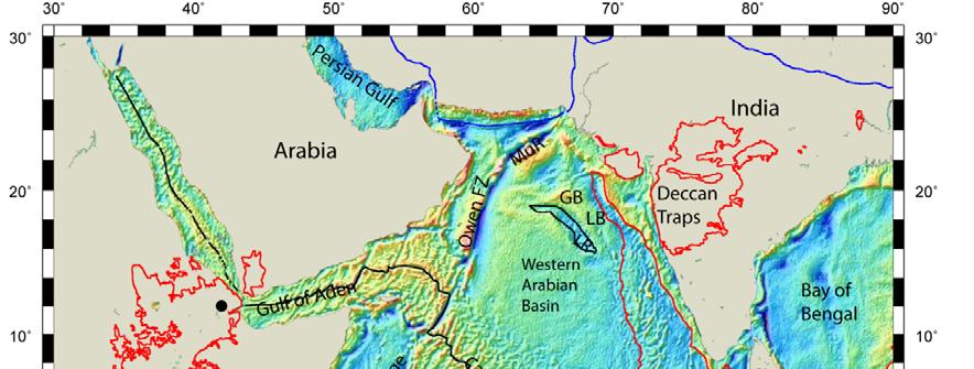
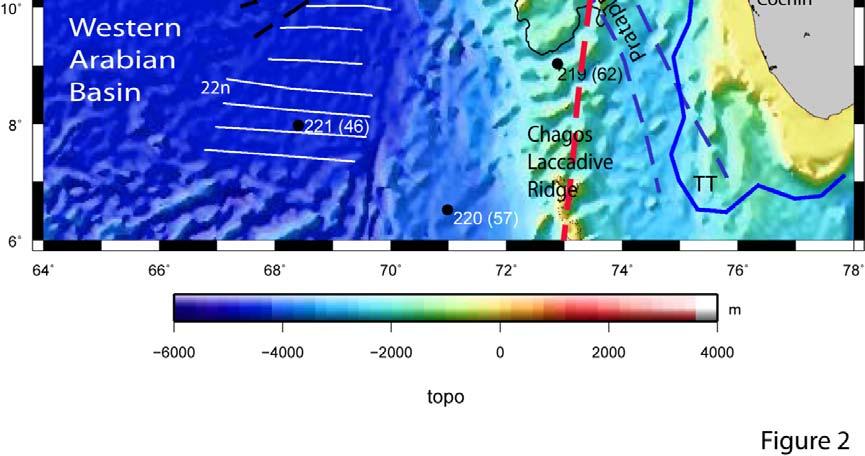
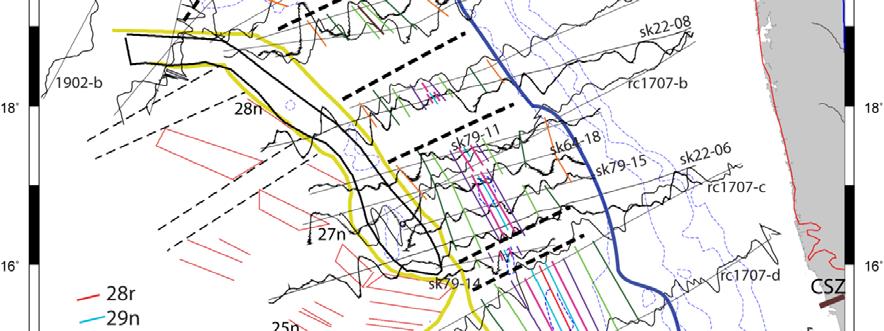
22 Figure Captions 1. Satellite gravity of the western Indian Ocean (Sandwell and Smith, 2009) showing the various tectonic elements referred in the present study. The present day mid-oceanic ridge system is shown as a black line. The red outline denotes the Large Igneous Provinces (Coffin and Eldholm, 1994). Black dots show the present day location of the hotspots. AR: Amirante Arc; CLR: Chagos- Laccadive Ridge; GB: Gop Basin; LB: Laxmi Basin; LR: Laxmi Ridge; Mabt: Madagascar Bight; MaR: Madagascar Ridge; MP: Mascarene Plateau; MuR: Murray Ridge; S: Seychelles; SEIR: Southeast Indian Ridge; SL: Sri Lanka; SMB: Saya de Malha Bank; SWIR: Southwest Indian Ridge. 2. Bathymetry map of the Arabian Sea (Smith and Sandwell, 1997) showing the main tectonic and structural features. Pseudofaults (black dashed lines) and magnetic lineations (white thin lines, some are annotated) are from Chaubey et al. (1998) and Bhattacharya et al. (1994a). The yellow dashed and thin lines indicate fracture zones and magnetic lineations respectively (Todal and Eldholm, 1998). The pink continuous line and dashed lines represents the Gop Rift and fracture zones respectively (Malod et al., 1997). Location of DSDP sites (Whitmarsh, 1974) are shown as black circles with basement age in Ma in bracket. The extent of the onshore Deccan volcanism is shown in red outline. The extent of the Dharwar Craton is shown in purple outline. Reunion hotspot track shown as thick red dashed line and its initial age are from Duncan (1990). The 2000 m isobath of the Laccadive Ridge is shown as thin black outline. The extent of the gravity low of the Laxmi Ridge is shown as thick black outline. The axis of the Palitana Ridge (PR) is shown in brown. Dashed brown lines represent the shear zones on Indian mainland. The Narmada-Son lineament (NSL) is shown as thick green dashed line. The Trivandrum Terrace (TT) is shown as a thick blue outline. BSZ: Bhavani Shear Zone; CSZ: Chapporo Shear Zone; EAB: Eastern Arabian Basin; LR: Laxmi Ridge; LaB: Laccadive Basin. 3. Magnetic anomaly dataset used in the present study are plotted in different colours along the tracks. Bathymetry is shown as thin black dashed lines. The extent of the gravity low of the Laxmi Ridge is shown as thick black outline. 4. Synthetic seafloor spreading models (black) generated using the geomagnetic polarity time scale of Gradstein et al. (2004) for the key profiles (red). Gravity and bathymetry along these profiles is plotted in green and blue respectively. Half-spreading rates in cm/yr are indicated. Dashed line represents the extinct spreading ridge axis having different timings of extinction. Models have been generated assuming 500 m thick source layer at a paleolatitude of 19 S (Bhattacharya et al., 1994a) now observed at 17 N, 70 E. The spreading ridge strike is N20 W with a remanent magnetization of 0.05 A/m. Normally magnetized blocks are shown in black. R is the location of the Laxmi Ridge. 5. Interpretation of the magnetic profiles used in the present study. The identified magnetic anomalies are shown in different colours as per legend. The extent of the Laxmi Ridge is shown as black dashed outline. The boundaries of the gravity low separating the older and younger regions, and the likely seaward edge of the continent-ocean transition (COT) are also marked (Sandwell and Smith, 2009). 6. Magnetic anomaly identifications made in the present study are shown as per legend on the track map. The extent of the gravity low of the Laxmi Ridge is shown as black outline. The extent of the low gravity signature bounding the older and younger regions and the likely seaward edge of the continent-ocean transition (COT) is indicated. Fracture zones are marked as thick black dashed 22
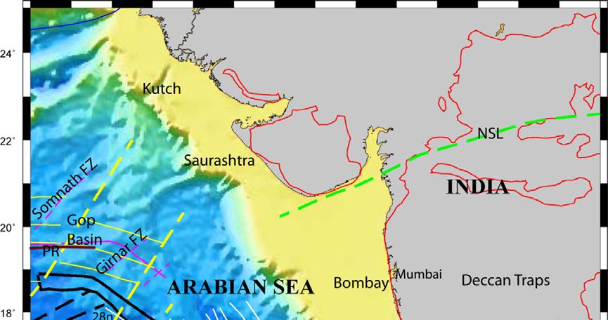
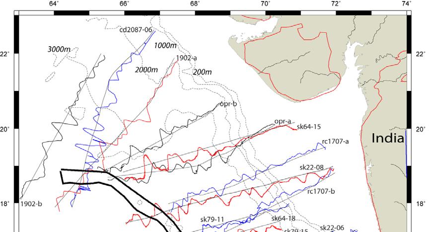
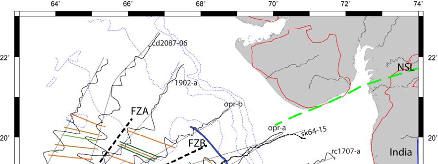
23 lines. The pseudofaults (thin black dashed lines) and magnetic lineations (red lines) are from Chaubey et al. (1998). The 2000 m isobath of the Laccadive Ridge is shown as green outline. The extent of the onshore Deccan volcanism is shown in red outline. The thick brown line represents the Chapporo Shear Zone (CSZ). The Narmada-Son lineament (NSL) is shown as green dashed line. FZA and FZB are the inferred fracture zones bounding the central zone where extinction took place at 71 Ma. 7. (a to f) Plate reconstruction models for different timings depicting the evolution of the study area. The isochrons of Gibbons et al. (2013) are shown in pink in the first three reconstructions to demonstrate the preservation of the fit of the surrounding plates. The prominent fracture zones in the Mascarene, Laxmi and Gop Basins are shown as black lines. Magnetic anomalies in the Mascarene Basin (Bernard and Munschy, 2000) are shown in different colours as per legend, some are annotated. Magnetic identifications inferred in the present study in the Gop and Laxmi Basins are shown as dots, blue - on the Indian plate and red on the Seychelles-Laxmi Ridge microplate. Black arrow depicts the direction of initiation of seafloor spreading. The shear zones in the Indian subcontinent are shown as dashed lines. A: Africa; AR: Amirante Arc; GB: Gop Basin; I: India; LR: Laxmi Ridge; LaR: Laccadive Ridge; LB: Laxmi Basin; M: Madagascar; MB: Mascarene Basin; MP: Mascarene Plateau. NSL: Narmada Son Lineament; S: Seychelles; SL: Sri Lanka; SMB: Saya de Malha Bank; TT: Trivandrum Terrace; WZFZ: Wallaby-Zenith Fracture Zone. For every chron, the region in the blue box is enlarged separately for clarity purpose. List of tables Table 1: Plate reconstruction parameters of relative rotations with respect to fixed Madagascar plate (702). Numbers in brackets are Plate IDs used in GPlates software, (Boyden et al., 2011). Table 2: Table depicting the opening and extinction timings in the Gop and Laxmi Basins inferred from earlier works and the present study. Table 3: Table describing the sequence of events during the three-stage evolutionary history of the India-Africa spreading corridor inferred from earlier works and the present study. 23
24 24
25 25
26 26

27 27


28 28
29 29
Fig Available seismic reflection, refraction, and magnetic profiles from 107 the Offshore Indus Basin close to the representative profile GCDH,
 List of Figures Page No. Fig. 1.1 Generalized physiography of the Indian Ocean along with 2 selected (200 m, 1000 m, 2000 m, and 3000 m) bathymetric contours. Fig. 1.2 Lithospheric plates in the Indian
Laxmi Ridge A continental sliver in the Arabian Sea
 Marine Geophysical Researches 20: 259 271, 1998. 1998 Kluwer Academic Publishers. Printed in the Netherlands. 259 Laxmi Ridge A continental sliver in the Arabian Sea Manik Talwani 1 & Christine Reif 1
CHAPTER I INTRODUCTION
 CHAPTER NTRODUCTON 1.1 GENERAL NTRODUCTON The ndian Ocean is bounded by the Africa, ndia, Australia and Antarctica continents which were formed after the break-up of Gondwanaland. The evolutionary history
Geological features and geophysical signatures of continental margins of India
 Geological features and geophysical signatures of continental margins of India K. S. Krishna National Institute of Oceanography, Dona Paula, Goa-43 4. krishna@nio.org The shape and classification of continental
Continental Margin Geology of Korea : Review and constraints on the opening of the East Sea (Japan Sea)
") Continental Margin Geology of Korea : Review and constraints on the opening of the East Sea (Japan Sea) Han-Joon Kim Marine Satellite & Observation Tech. Korea Ocean Research and Development Institute
Continental Margin Geology of Korea : Review and constraints on the opening of the East Sea (Japan Sea) Han-Joon Kim Marine Satellite & Observation Tech. Korea Ocean Research and Development Institute
Mesozoic Enigma in Kerala-Konkan Basin: An alternate explanation for deep water sub-basalt reflections
 10 th Biennial International Conference & Exposition P 352 Summary Mesozoic Enigma in Kerala-Konkan Basin: An alternate explanation for deep water sub-basalt reflections K C Das Kerala-Konkan basin a volcanic
Introduction to Oceanography. Chapter 2: Plate Tectonics Overview
 Introduction to Oceanography Chapter 2: Plate Tectonics Overview Much evidence supports plate tectonics theory. The plate tectonics model describes features and processes on Earth. Plate tectonic science
What Forces Drive Plate Tectonics?
 What Forces Drive Plate Tectonics? The tectonic plates are moving, but with varying rates and directions. What hypotheses have been proposed to explain the plate motion? Convection Cells in the Mantle
Global Tectonics. Kearey, Philip. Table of Contents ISBN-13: Historical perspective. 2. The interior of the Earth.
 Global Tectonics Kearey, Philip ISBN-13: 9781405107778 Table of Contents Preface. Acknowledgments. 1. Historical perspective. 1.1 Continental drift. 1.2 Sea floor spreading and the birth of plate tectonics.
FOOT OF THE CONTINENTAL SLOPE IN ARTICLE 76
 FOOT OF THE CONTINENTAL SLOPE IN ARTICLE 76 Vaughan Stagpoole, Institute of Geological & Nuclear Sciences, Lower Hutt, New Zealand, v.stagpoole@gns.cri.nz Ray Wood, Institute of Geological & Nuclear Sciences,
WHAT IS THE THICKNESS OF EARTH S CRUST?
 WHAT IS THE THICKNESS OF EARTH S CRUST? Image: Yerko Espinoza/shutterstock.com Andy Alvey, Alan Roberts* and Nick Kusznir discuss how a new global map of crustal thickness is illuminating complexity in
SEAWARD DIPPING REFLECTORS AND CRUSTAL STRUCTURE
 SEAWARD DIPPING REFLECTORS AND CRUSTAL STRUCTURE SEAWARD DIPPING REFLECTORS AND CRUSTAL STRUCTURE 6.1 Introduction The western continental margin of India is considered as a typical passive rifted margin
Earth s Continents and Seafloors. GEOL100 Physical Geology Ray Rector - Instructor
 Earth s Continents and Seafloors GEOL100 Physical Geology Ray Rector - Instructor OCEAN BASINS and CONTINENTAL PLATFORMS Key Concepts I. Earth s rocky surface covered by of two types of crust Dense, thin,
Questions and Topics
 Plate Tectonics and Continental Drift Questions and Topics 1. What are the theories of Plate Tectonics and Continental Drift? 2. What is the evidence that Continents move? 3. What are the forces that
Chapter-2 GEOLOGY AND TECTONIC SCENARIO
 GEOLOGY AND TECTONIC SCENARIO GEOLOGY AND TECTONIC SCENARIO 2.1 Introduction The present day geology and tectonic scenario of the western continental margin of India is mainly the result of rifting of
The breakup of East Gondwana: Assimilating constraints from Cretaceous ocean basins around India into a best-fit tectonic model
 JOURNAL OF GEOPHYSICAL RESEARCH: SOLID EARTH, VOL. 118, 808 822, doi:10.1002/jgrb.50079, 2013 The breakup of East Gondwana: Assimilating constraints from Cretaceous ocean basins around India into a best-fit
Essentials of Oceanography Eleventh Edition
 Chapter Chapter 1 2 Clickers Lecture Essentials of Oceanography Eleventh Edition Plate Tectonics and the Ocean Floor Alan P. Trujillo Harold V. Thurman Chapter Overview Much evidence supports plate tectonics
Alfred Wegener gave us Continental Drift. Fifty years later...
 CHAPTER 2 Plate Tectonics and the Ocean Floor Plate Tectonics: summary in haiku form Alfred Wegener gave us Continental Drift. Fifty years later... Words Chapter Overview Much evidence supports plate tectonics
24. Ocean Basins p
 24. Ocean Basins p. 350-372 Background The majority of the planet is covered by ocean- about %. So the majority of the Earth s crust is. This crust is hidden from view beneath the water so it is not as
Chapter 02 The Sea Floor
 Chapter 02 The Sea Floor Multiple Choice Questions 1. One of the following is not one of the world's major ocean basins: A. Atlantic Ocean B. Arctic Ocean C. Indian Ocean D. Antarctic Ocean E. Pacific
Continental Drift and Plate Tectonics
 Continental Drift and Plate Tectonics Continental Drift Wegener s continental drift hypothesis stated that the continents had once been joined to form a single supercontinent. Wegener proposed that the
Author version: Earth Planet. Sci. Lett.: 284(3-4); 2009; Early Oceanic Opening off Western India-Pakistan Margin: the Gop Basin Revisited
; 2009; Early Oceanic Opening off Western India-Pakistan Margin: the Gop Basin Revisited") Author version: Earth Planet. Sci. Lett.: 284(3-4); 2009; 399-408 Early Oceanic Opening off Western India-Pakistan Margin: the Gop Basin Revisited V. Yatheesh 1, 2,*, G.C. Bhattacharya 1, J. Dyment 2 1
Author version: Earth Planet. Sci. Lett.: 284(3-4); 2009; 399-408 Early Oceanic Opening off Western India-Pakistan Margin: the Gop Basin Revisited V. Yatheesh 1, 2,*, G.C. Bhattacharya 1, J. Dyment 2 1
3. The diagram below shows how scientists think some of Earth's continents were joined together in the geologic past.
 1. The map below shows the present-day locations of South America and Africa. Remains of Mesosaurus, an extinct freshwater reptile, have been found in similarly aged bedrock formed from lake sediments
10. Paleomagnetism and Polar Wandering Curves.
 Map of ocean floor Evidence in Support of the Theory of Plate Tectonics 10. Paleomagnetism and Polar Wandering Curves. The Earth's magnetic field behaves as if there were a bar magnet in the center of
A) B) C) D) 4. Which diagram below best represents the pattern of magnetic orientation in the seafloor on the west (left) side of the ocean ridge?
 B) C) D) 4. Which diagram below best represents the pattern of magnetic orientation in the seafloor on the west (left) side of the ocean ridge?") 1. Crustal formation, which may cause the widening of an ocean, is most likely occurring at the boundary between the A) African Plate and the Eurasian Plate B) Pacific Plate and the Philippine Plate C)
1. Crustal formation, which may cause the widening of an ocean, is most likely occurring at the boundary between the A) African Plate and the Eurasian Plate B) Pacific Plate and the Philippine Plate C)
TH P5 07 INSIGHTS INTO THE TECTONIC EVOLUTION AND PROSPECTIVITY OF MADAGASCAR OFFSHORE BASINSN
 Technical paper TH P5 07 INSIGHTS INTO THE TECTONIC EVOLUTION AND PROSPECTIVITY OF MADAGASCAR OFFSHORE BASINSN Authors R. Dirkx* (TGS), F. Winter (TGS), S. Musa (TGS), R. Cooke (TGS), B. Sayers (TGS),
Plate Tectonics. entirely rock both and rock
 Plate Tectonics I. Tectonics A. Tectonic Forces are forces generated from within Earth causing rock to become. B. 1. The study of the origin and arrangement of Earth surface including mountain belts, continents,
Copyright McGraw-Hill Education. All rights reserved. No reproduction or distribution without the prior written consent of McGraw-Hill Education
 Copyright McGraw-Hill Education. All rights reserved. No reproduction or distribution without the prior written consent of McGraw-Hill Education Tibetan Plateau and Himalaya -southern Asia 11.00.a VE 10X
OCN 201 Mantle plumes and hot spots
 OCN 201 Mantle plumes and hot spots Question Long-term (>50 million years) changes in sea level are caused by: A. Changes in the volume of water in the ocean B. Changes in the volume of the ocean basins
Before Plate Tectonics: Theory of Continental Drift
 Before Plate Tectonics: Theory of Continental Drift Predecessor to modern plate tectonics Shape and fit of the continents was the initial evidence Snider-Pelligrini (1858) Taylor (1908) Wegner (1915) Fig.
GENERAL GEOLOGY Fall Chapter 18: The Sea Floor. Partial Examination IV Study Guide Dr. Glen S. Mattioli
 GENERAL GEOLOGY 1113-005 Fall 2008 Partial Examination IV Study Guide Dr. Glen S. Mattioli Note that these are NOT questions, but rather are a list of topics that we have covered either in class or are
PHYSICAL GEOLOGY AND THE ENVIRONMENT (2 ND CANADIAN EDITION)
") Chapter 2: Plate Tectonics Chapter Summary: Plate tectonics is a theory that suggests Earth's surface is divided into several large plates that change position and size. Intense geologic activity occurs
Chapter 2: Plate Tectonics Chapter Summary: Plate tectonics is a theory that suggests Earth's surface is divided into several large plates that change position and size. Intense geologic activity occurs
The Sea Floor. Chapter 2
 The Sea Floor Chapter 2 Geography of the Ocean Basins World ocean is the predominant feature on the Earth in total area Northern Hemisphere = 61% of the total area is ocean. Southern Hemisphere = about
Seaward dipping reflectors along the SW continental margin of India: Evidence for volcanic passive margin
 Seaward dipping reflectors along the SW continental margin of India: Evidence for volcanic passive margin KKAjay 1,, A K Chaubey 1,, K S Krishna 1,DGopalaRao 2 and DSar 3 1 National Institute of Oceanography
Plate Tectonics: A Unifying Theory
 Plate Tectonics: A Unifying Theory What is Plate Tectonics? - 7 large tectonic plates and many smaller ones that break up the lithosphere - Plates are brittle and float on asthenosphere and glide past
Prentice Hall EARTH SCIENCE
 Prentice Hall EARTH SCIENCE Tarbuck Lutgens Chapter 9 Plate Tectonics 9.1 Continental Drift An Idea Before Its Time Wegener s continental drift hypothesis stated that the continents had once been joined
Prentice Hall EARTH SCIENCE
 Prentice Hall EARTH SCIENCE Tarbuck Lutgens Chapter 9 Plate Tectonics 9.1 Continental Drift An Idea Before Its Time Wegener s continental drift hypothesis stated that the continents had once been joined
Geology 300, Physical Geology Spring 2019 Quiz Ch 19, Plate Tectonics Name
 Geology 300, Physical Geology Spring 2019 Quiz Ch 19, Plate Tectonics Name MULTIPLE CHOICE. Choose the one alternative that best completes the statement or answers the question. 1) The portion of a fracture
Introduction To Plate Tectonics Evolution. (Continents, Ocean Basins, Mountains and Continental Margins)
") Introduction To Plate Tectonics Evolution (Continents, Ocean Basins, Mountains and Continental Margins) Geo 386 (Arabian Shield Course) Dr. Bassam A. A. Abuamarah Mohanna G E O 3 8 6 A R A B I A N G E
Introduction To Plate Tectonics Evolution (Continents, Ocean Basins, Mountains and Continental Margins) Geo 386 (Arabian Shield Course) Dr. Bassam A. A. Abuamarah Mohanna G E O 3 8 6 A R A B I A N G E
Structure and Evolution of Saurashtra Arch in Kutch- Saurashtra Deepwater Area, Western India.
 Summary Structure and Evolution of Saurashtra Arch in Kutch- Saurashtra Deepwater Area, Western India. Kunduri Sriram, S. S. Gupte, V. Kothari, Madhu Bisen and R. S. Waraich. BSD, KDMIPE, ONGC, Dehra Dun-248195,
PLATE TECTONICS. Continental Drift. Continental Drift. Continental Drift. Continental Drift- Wegener s Evidence
 Continental Drift PLATE TECTONICS E.B. Taylor (1910) and Alfred Wegener (1915) published on Continental Drift. Continental Drift Wegener s evidence 1. Fit of the Continents 2. Fossil Evidence 3. Rock Type
6. In the diagram below, letters A and B represent locations near the edge of a continent.
 1. Base your answer to the following question on the cross section below and on your knowledge of Earth science. The cross section represents the distance and age of ocean-floor bedrock found on both sides
DEEPWATER WEST COAST INDIA: PRE BASALT AND OTHER MESOZOIC PLAYS
 DEEPWATER WEST COAST INDIA: PRE BASALT AND OTHER MESOZOIC PLAYS Glyn Roberts 1, Charles Harmer 2, Ken Rutherford 3 & Colin O Brien 4 ( 1 Consultant, Spectrum a.s.a, 2 Spectrum a.s.a, 3 Rutherford Exploration
Earthquakes. Earthquakes are caused by a sudden release of energy
 Earthquakes Earthquakes are caused by a sudden release of energy The amount of energy released determines the magnitude of the earthquake Seismic waves carry the energy away from its origin Fig. 18.1 Origin
Chapter 2 Plate Tectonics and the Ocean Floor
 Chapter 2 Plate Tectonics and the Ocean Floor Chapter Overview Much evidence supports plate tectonics theory. The plate tectonics model describes features and processes on Earth. Plate tectonic science
Chapter Overview. Evidence for Continental Drift. Plate Tectonics. Evidence for Continental Drift. Evidence for Continental Drift 9/28/2010
 Chapter Overview CHAPTER 2 Plate Tectonics and the Ocean Floor Much evidence supports plate tectonics theory. Different plate boundaries have different features. Tectonic plates continue to move today.
Dynamic Crust Practice
 1. Base your answer to the following question on the cross section below and on your knowledge of Earth science. The cross section represents the distance and age of ocean-floor bedrock found on both sides
USU 1360 TECTONICS / PROCESSES
 USU 1360 TECTONICS / PROCESSES Observe the world map and each enlargement Pacific Northwest Tibet South America Japan 03.00.a1 South Atlantic Arabian Peninsula Observe features near the Pacific Northwest
Crustal Boundaries. As they move across the asthenosphere and form plate boundaries they interact in various ways. Convergent Transform Divergent
 Name: Date: Period: Plate Tectonics The Physical Setting: Earth Science CLASS NOTES Tectonic plates are constantly moving and interacting As they move across the asthenosphere and form plate boundaries
DEEP WATER WEST COAST INDIA THE OPENING OF A NEW PLAY BENEATH THE DECCAN BASALTS
 DEEP WATER WEST COAST INDIA THE OPENING OF A NEW PLAY BENEATH THE DECCAN BASALTS Glyn Roberts 1, Charles Harmer 2, Ken Rutherford 3, Colin O Brien 4 1 Consultant, UK; 2 Spectrum Geo, UK; 3 Rutherford Exploration
Full file at
 Essentials of Oceanography, 10e (Trujillo/Keller) Chapter 2 Plate Tectonics and the Ocean Floor Match the term with the appropriate phrase. You may use each answer once, more than once or not at all. A)
Chapter 2 Plate Tectonics and the Ocean Floor
 Chapter 2 Plate Tectonics and the Ocean Floor Matching. Match the term or person with the appropriate phrase. You may use each answer once, more than once or not at all. 1. hydrothermal vents A. convergent
Chapter Two. Figure 02_02. Geography of the Ocean Basins. The Sea Floor
 Chapter Two The Sea Floor Geography of the Ocean Basins Figure 02_02 The world ocean is the predominant feature on the Earth in total area. In the Northern Hemisphere, 61% of the total area is ocean. In
CHAPTER 2 THE WAY THE EARTH WORKS: EXAMINING PLATE TECTONICS
 CHAPTER 2 THE WAY THE EARTH WORKS: EXAMINING PLATE TECTONICS Coverage of plate tectonics is required early in introductory Geology as context for the mineralogy, petrology, structure, internal processes,
Map shows 3 main features of ocean floor
 Map shows 3 main features of ocean floor 2017 Pearson Education, Inc. Chapter 3 Marine Provinces 2017 Pearson Education, Inc. 1 Chapter 3 Overview The study of bathymetry determines ocean depths and ocean
Bathymetry Measures the vertical distance from the ocean surface to mountains, valleys, plains, and other sea floor features
 1 2 3 4 5 6 7 8 9 10 11 CHAPTER 3 Marine Provinces Chapter Overview The study of bathymetry determines ocean depths and ocean floor topography. Echo sounding and satellites are efficient bathymetric tools.
Divergent Boundaries: Origin and Evolution of the Ocean Floor Earth - Chapter 13 Stan Hatfield Southwestern Illinois College
 Divergent Boundaries: Origin and Evolution of the Ocean Floor Earth - Chapter 13 Stan Hatfield Southwestern Illinois College Mapping the Ocean Floor Depth was originally measured by lowering weighted lines
Chapter Overview. Bathymetry. Measuring Bathymetry. Measuring Bathymetry
 CHAPTER 3 Marine Provinces Chapter Overview The study of bathymetry determines ocean depths and ocean floor topography. Echo sounding and satellites are efficient bathymetric tools. Most ocean floor features
OCN 201 Seafloor Spreading and Plate Tectonics. Question
 OCN 201 Seafloor Spreading and Plate Tectonics Question What was wrong from Wegener s theory of continental drift? A. The continents were once all connected in a single supercontinent B. The continents
Chapter 1. Introduction
 Chapter 1 Introduction 1.1 General Background The oceans, which cover about 71% of the earth s surface, are considered as a future potential reserve for both living and non-living resources. The dwindling
Dating of the 85 E Ridge (northeastern Indian Ocean) using marine magnetic anomalies
 using marine magnetic anomalies") Dating of the 85 E Ridge (northeastern Indian Ocean) using marine magnetic anomalies Laju Michael and K. S. Krishna* National Institute of Oceanography (CSIR), Dona Paula, Goa 403 004, India The 85 E Ridge
Dating of the 85 E Ridge (northeastern Indian Ocean) using marine magnetic anomalies Laju Michael and K. S. Krishna* National Institute of Oceanography (CSIR), Dona Paula, Goa 403 004, India The 85 E Ridge
Lecture #13 notes, Geology 3950 Spring 2006: CR Stern Magnetic reversals (text pages th edition and in the 5 th edition)
") Lecture #13 notes, Geology 3950 Spring 2006: CR Stern Magnetic reversals (text pages 35-37 4 th edition and 53-55 in the 5 th edition) The earth has a magnetic field generated by circulation of charged
Lecture #13 notes, Geology 3950 Spring 2006: CR Stern Magnetic reversals (text pages 35-37 4 th edition and 53-55 in the 5 th edition) The earth has a magnetic field generated by circulation of charged
Lab 1: Plate Tectonics April 2, 2009
 Name: Lab 1: Plate Tectonics April 2, 2009 Objective: Students will be introduced to the theory of plate tectonics and different styles of plate margins and interactions. Introduction The planet can be
Evolution of Continents Chapter 20
 Evolution of Continents Chapter 20 Does not contain complete lecture notes. Mountain belts Orogenesis the processes that collectively produce a mountain belt Includes folding, thrust faulting, metamorphism,
Plate Tectonics. Essentials of Geology, 11 th edition Chapter 15
 1 Plate Tectonics Essentials of Geology, 11 th edition Chapter 15 2 3 4 5 6 7 8 9 10 11 12 13 14 15 Plate Tectonics: summary in haiku form Alfred Wegener gave us Continental Drift. Fifty years later...
In the space provided, write the letter of the definition that best matches the term or phrase.
 Skills Worksheet Directed Reading Section: The Changing Continents 1. What is the result of slow movements of tectonic plates? RESHAPING EARTH S CRUST In the space provided, write the letter of the definition
Controls on clastic systems in the Angoche basin, Mozambique: tectonics, contourites and petroleum systems
 P2-2-13 Controls on clastic systems in the Angoche basin, Mozambique: tectonics, contourites and petroleum systems Eva Hollebeek, Olivia Osicki, Duplo Kornpihl Schlumberger, London, UK Introduction Offshore
Practice Questions: Plate Tectonics
 Practice Questions: Plate Tectonics 1. Base your answer to the following question on The block diagram below shows the boundary between two tectonic plates. Which type of plate boundary is shown? A) divergent
Sir Francis Bacon, 1620, noted that the continental coasts on opposites sides of the Atlantic fit together like puzzle pieces.
 Plate Tectonics Sir Francis Bacon, 1620, noted that the continental coasts on opposites sides of the Atlantic fit together like puzzle pieces. Could North and South America once have been joined to Europe
FINDING THE CONTINENTAL SHELF EXAMPLES FROM THE NEW ZEALAND REGION
 FINDING THE CONTINENTAL SHELF EXAMPLES FROM THE NEW ZEALAND REGION ABSTRACT New Zealand has nearly completed the surveying phase of its Continental Shelf Project. Some surveys have been designed to fill
Geoid and gravity anomaly data of conjugate regions of Bay of Bengal and. Enderby Basin new constraints on breakup and early spreading history
 Author version: J. Geophys. Res. (B: Solid Earth): 114(3); 29; 21 pp; doi:1.129/28jb88 Geoid and gravity anomaly data of conjugate regions of Bay of Bengal and Enderby Basin new constraints on breakup
Motion between the Indian, Antarctic and African plates in the early Cenozoic
 Motion between the Indian, Antarctic and African plates in the early Cenozoic Steven Cande, Philippe Patriat, Jerome Dyment To cite this version: Steven Cande, Philippe Patriat, Jerome Dyment. Motion between
Full file at
 Chapter 2 PLATE TECTONICS AND PHYSICAL HAZARDS MULTIPLE-CHOICE QUESTIONS 1. What direction is the Pacific Plate currently moving, based on the chain of Hawaiian Islands with only the easternmost island
The Lithosphere and the Tectonic System. The Structure of the Earth. Temperature 3000º ºC. Mantle
 The Lithosphere and the Tectonic System Objectives: Understand the structure of the planet Earth Review the geologic timescale as a point of reference for the history of the Earth Examine the major relief
Foundations of Earth Science Seventh Edition
 Chapter 5 Lecture Outline Foundations of Earth Science Seventh Edition Plate Tectonics: A Scientific Revolution Unfolds Natalie Bursztyn Utah State University From Continental Drift to Plate Tectonics
5: ABSOLUTE PLATE MOTIONS & HOTSPOTS
 5-1 5: ABSOLUTE PLATE MOTIONS & HOTSPOTS 1 Relative motions between plates are most important In some applications important to consider absolute plate motions, those with respect to the deep mantle ABSOLUTE
D. Ravat University of Kentucky Nils Olsen, Chris Finlay, Livia Kother DTU, Technical University of Denmark. With contributions from Mike Purucker
 LCS-1: First lithospheric magnetic field model from CHAMP and Swarm satellites magnetic gradient observations and implications for magnetic anomaly interpretation D. Ravat University of Kentucky Nils Olsen,
Palaeozoic oceanic crust preserved beneath the eastern Mediterranean
 Palaeozoic oceanic crust preserved beneath the eastern Mediterranean Roi Granot Magnetic Anomaly Data Total field Three components 75 m 75 m Total field 250 m Overhauser Three-axial fluxgate Overhauser
Physical Geology, 15/e
 Lecture Outlines Physical Geology, 15/e Plummer, Carlson & Hammersley Plate Tectonics: The Unifying Theory Physical Geology 15/e, Chapter 19 Plate Tectonics Plate Tectonics Earth s surface is composed
Plate Tectonics. Structure of the Earth
 Plate Tectonics Structure of the Earth The Earth can be considered as being made up of a series of concentric spheres, each made up of materials that differ in terms of composition and mechanical properties.
Convolution of Technology and Concepts Entails Enticing Deepwater Opportunities, India
 P - 405 Convolution of Technology and Concepts Entails Enticing Deepwater Opportunities, India Duggirala Moses Nathaniel, Rabi Bastia, Srinivas Tenepalli, Kenneth D Silva, Ravi Verma Petroleum Business
Sager, W.W., Bull, J.M. and Krishna, K.S. (2013) Active faulting on. the Ninetyeast Ridge and its relation to deformation of the Indo-
 Active faulting on. the Ninetyeast Ridge and its relation to deformation of the Indo-") 1 2 3 4 5 Sager, W.W., Bull, J.M. and Krishna, K.S. (2013) Active faulting on the Ninetyeast Ridge and its relation to deformation of the Indo- Australian plate. Journal of Geophysical Research: Solid
1 2 3 4 5 Sager, W.W., Bull, J.M. and Krishna, K.S. (2013) Active faulting on the Ninetyeast Ridge and its relation to deformation of the Indo- Australian plate. Journal of Geophysical Research: Solid
Captain s Tryouts 2017
 Captain s Tryouts 2017 Dynamic Planet Test Written by: Araneesh Pratap (Chattahoochee High School) Name: Date: Answer all questions on the answer sheet. Point values are given next to each question or
Plate Tectonics. 1)The plate tectonic system 2)A theory is born 3) Early evidence for continental drift 4) Continental drift and paleomagnetism
The plate tectonic system 2)A theory is born 3) Early evidence for continental drift 4) Continental drift and paleomagnetism") Plate Tectonics Plate boundaries 1)The plate tectonic system 2)A theory is born 3) Early evidence for continental drift 4) Continental drift and paleomagnetism 6)History and future of plate motions system
Plate Tectonics Plate boundaries 1)The plate tectonic system 2)A theory is born 3) Early evidence for continental drift 4) Continental drift and paleomagnetism 6)History and future of plate motions system
MARINE GEOLOGY & GEOGRAPHY
 MARINE GEOLOGY MARINE GEOLOGY & GEOGRAPHY Marine Geology 4 LAYERS OF THE EARTH CRUST THICKNESS: VARIES BETWEEN OCEAN & CONTINENTS 5-40 KM STATE: SOLID ELEMENTS: SILICON, ALUMINUM, CALCIUM, SODIUM, POTASSIUM
60% water. Big Bang: 14,000 millions years ago The Earth originated about 4,500 millions years ago its orbit allows water to exist in a liquid state!
 Ch2. The Sea Floor #1 Why geology of the oceans? Marine habitats are directly shaped by geological processes The form of the coastlines The depth of the water Type of bottom (muddy, sandy, rocky) #2 Geological
MUHAMMAD S TAMANNAI, DOUGLAS WINSTONE, IAN DEIGHTON & PETER CONN, TGS Nopec Geological Products and Services, London, United Kingdom
 Geological and Geophysical Evaluation of Offshore Morondava Frontier Basin based on Satellite Gravity, Well and regional 2D Seismic Data Interpretation MUHAMMAD S TAMANNAI, DOUGLAS WINSTONE, IAN DEIGHTON
A new burst of seafloor mapping and discovery driven by advances in satellite altimetry
 A new burst of seafloor mapping and discovery driven by advances in satellite altimetry! R. Dietmar Müller*, Kara J. Matthews* and David T. Sandwell^! *EarthByte Group, School of Geosciences, The University
The anomalous high transverse ridge developed along a transform fault. Speaker: Yen-Fu Chen
 The anomalous high transverse ridge developed along a transform fault Speaker: Yen-Fu Chen Reference Anne E. Deschamps, Serge E. Lallemand, and Jean-Yves Collot, 1998, A detailed study of the Gagua Ridge:
Continental Landscapes
 Continental Landscapes Landscape influenced by tectonics, climate & differential weathering Most landforms developed within the last 2 million years System moves toward an equilibrium Continental Landscapes
Lecture Marine Provinces
 Lecture Marine Provinces Measuring bathymetry Ocean depths and topography of ocean floor Sounding Rope/wire with heavy weight Known as lead lining Echo sounding Reflection of sound signals 1925 German
Origin and Evolution of the Ocean Floor
 Origin and Evolution of the Ocean Floor Outline Mapping the Ocean Floor Continental Margins Origin of Oceanic Lithosphere Structure of Ocean Crust Mapping the ocean floor Depth originally measured by lowering
The influence of short wavelength variations in viscosity on subduction dynamics
 1 Introduction Deformation within the earth, driven by mantle convection due primarily to cooling and subduction of oceanic lithosphere, is expressed at every length scale in various geophysical observations.
A comparison of structural styles and prospectivity along the Atlantic margin from Senegal to Benin. Peter Conn*, Ian Deighton* & Dario Chisari*
 A comparison of structural styles and prospectivity along the Atlantic margin from Senegal to Benin Overview Peter Conn*, Ian Deighton* & Dario Chisari* * TGS, Millbank House, Surbiton, UK, KT6 6AP The
Laboratory #7: Plate Tectonics
 Materials Needed: 1. Pencil 2. Colored Pencils 3. Metric/Standard Ruler 4. Calculator 5. Tracing Paper Laboratory #7: Plate Tectonics Plate Tectonics The Earth is composed of layers. At the center is a
Seafloor Morphology. Techniques of Investigation. Bathymetry and Sediment Studies
 Seafloor Morphology I f we select a grid for the surface of the earth (i.e. 5 km 2 ) and assign it an average elevation in relation to sea level, we can construct a graph of elevation versus area of the
OCN 201: Seafloor Spreading and Plate Tectonics I
 OCN 201: Seafloor Spreading and Plate Tectonics I Revival of Continental Drift Theory Kiyoo Wadati (1935) speculated that earthquakes and volcanoes may be associated with continental drift. Hugo Benioff
Marine Science and Oceanography
 Marine Science and Oceanography Marine geology- study of the ocean floor Physical oceanography- study of waves, currents, and tides Marine biology study of nature and distribution of marine organisms Chemical
Plate Tectonics: A Scientific Revolution Unfolds
 Chapter 2 Lecture Earth: An Introduction to Physical Geology Eleventh Edition Plate Tectonics: A Scientific Revolution Unfolds Tarbuck and Lutgens From Continental Drift to Plate Tectonics Prior to the
Whole Earth Structure and Plate Tectonics
 Whole Earth Structure and Plate Tectonics Processes in Structural Geology & Tectonics Ben van der Pluijm WW Norton+Authors, unless noted otherwise 4/5/2017 14:45 We Discuss Whole Earth Structure and Plate