ANDMARK. Laurel 2 Solar Site SEC Liebert Road and Wixom Road El Centro, California. Preliminary Geotechnical and GeoHazards Report 90FI 8ME, LLC
|
|
|
- Morgan Hodge
- 5 years ago
- Views:
Transcription

1 Preliminary Geotechnical and GeoHazards Report Laurel 2 Solar Site SEC Liebert Road and Wixom Road El Centro, California Prepared for: 90FI 8ME, LLC 211 Sutter Street, 6 th Floor San Francisco, CA L ANDMARK Geo-Engineers and Geologists Prepared by: Landmark Consultants, Inc. 780 N. 4 th Street El Centro, CA (760) August 2017
2 L ANDMARK Geo-Engineers and Geologists 780 N. 4th Street El Centro, CA (760) (760) fax August 31, Wildcat Drive Palm Desert, CA (760) (760) fax Mr. Daniel Kolta 90FI 8ME, LLC 211 Sutter Street, 6 th Floor San Francisco, CA Preliminary Geological and Geotechnical Hazard Evaluation Laurel 2 Solar Site SEC Liebert Road and Wixom Road El Centro, California LCI Project No. LE17141 Dear Mr. Kolta: This preliminary geotechnical report and geologic hazards study is provided for preliminary site evaluation and permitting of the photo-voltaic solar farm at the approximately 280-acre project area (APNs , , and ) located at the southeast and northwest corners of Vaughn Road and Jessup Road approximately 8 miles west of El Centro, California. Scope of Work The scope of work consisted of a geologic and geotechnical hazards evaluation of the project site which addresses the following items: 1. General site geology. 2. Site location in relation to mapped earthquake faults and seismic zones. 3. Intensity of ground shaking at the site. 4. Potential for liquefaction, ground failure, and landslides at the site. No drilling was conducted to determine potential for liquefaction settlement or soil analysis. 5. Soil corrosivity. 6. Plant growth suitability of the site soils. 7. Preliminary pavement structural sections. 8. Potential for flooding at the site from manmade facilities (dams, canals, etc.) and from natural storms. 9. Other potential geologic and geotechnical hazards.
3 Laurel 2 Solar Site SEC and NWC Jessup and Vaughn Roads El Centro, CA LCI Report No. LE17141 Site Description The project site is located at the southeast and northwest corners of Vaughn Road and Jessup Road approximately 8 miles west of El Centro, California. The project site consists of approximately 280-acres comprised of two separate parcels each consisting of two (2) agricultural fields currently in crop production. Parcel 1: Parcel 1 is comprised of two (2) agricultural fields totaling approximately 160 acres. The parcel is roughly square in plan view. The parcel is bounded on the south by Diehl Road and the west by Jessup Road. Derrick Road forms the eastern boundary of the site. A dirt field road and irrigation canal bisects the site in an east-west direction. Parcel 2: Parcel 2 is comprised of two (2) agricultural fields totaling approximately 120 acres. The parcel is roughly rectangular in plan view. The parcel is bounded on the south by Vaughn Road and the east by Jessup Road. Derrick Road forms the eastern boundary of the site. A dirt field road bisects the site in a north-south direction. Agricultural fields are located around the perimeter of the project site. Dirt field roads are located along the margins and also cross the parcels. The adjacent properties are approximately the same elevation as the project sites. Site Geological Conditions Site Geology: The project site is located in the Imperial Valley portion of the Salton Trough physiographic province. The Salton Trough is a topographic and geologic structural depression resulting from large scale regional faulting. The trough is bounded on the northeast by the San Andreas Fault and Chocolate Mountains and the southwest by the Peninsular Range and faults of the San Jacinto Fault Zone. The Salton Trough represents the northward extension of the Gulf of California, containing both marine and non-marine sediments since the Miocene Epoch. Tectonic activity that formed the trough continues at a high rate as evidenced by deformed young sedimentary deposits and high levels of seismicity. Figure 1 shows the location of the site in relation to regional faults and physiographic features. The Imperial Valley is directly underlain by lacustrine deposits, which consist of interbedded lenticular and tabular silt, sand, and clay. Based on Unified Soil Classification System, the permeability of these soils is expected to be low to moderate. Landmark Consultants, Inc. Page 2
4 Laurel 2 Solar Site SEC and NWC Jessup and Vaughn Roads El Centro, CA LCI Report No. LE17141 The Late Pleistocene to Holocene lake deposits are probably less than 100 feet thick and derived from periodic flooding of the Colorado River which intermittently formed a fresh water lake (Lake Cahuilla). Older deposits consist of Miocene to Pleistocene non-marine and marine sediments deposited during intrusions of the Gulf of California. Basement rock consisting of Mesozoic granite and Paleozoic metamorphic rocks are estimated to exist at depths between 15,000-20,000 feet. Groundwater: The groundwater in the site area is brackish and typically encountered at a depth of between 5 to 10 feet below ground surface in the vicinity of the project site. There is uncertainty in the accuracy of short-term water level measurements, particularly in fine-grained soil. Groundwater levels may fluctuate with precipitation, irrigation of adjacent properties, drainage, and site grading. The groundwater level noted should not be interpreted to represent an accurate or permanent condition. Onsite Wastewater Disposal: The near surface soils at the project site generally consist of silts and silty sands having a moderate infiltration rate. The near surface soils are considered good in supporting onsite septic systems and leach fields for wastewater disposal. Site specific studies will be required to determine that County Environmental Health standards are met in regard to soil percolation rates and separation of leach fields from groundwater. Geological Hazards Landsliding: No ancient landslides are shown on geologic maps of the region and no indications of landslides were observed during our site investigation. The hazard of landsliding is unlikely due to the relatively planar topography of the project site. Volcanic hazards: The site is not located proximal to any known volcanically active area and the risk of volcanic hazards is considered very low. Tsunamis, seiches, and flooding: The site does not lie near any large bodies of water, so the threat of tsunami, seiches, or other seismically-induced flooding is considered unlikely. The project site is located in FEMA Flood Zone X, an area determined to be outside the 0.2% annual chance floodplain (FIRM Panel 06025C1700C). Landmark Consultants, Inc. Page 3
5 Laurel 2 Solar Site SEC and NWC Jessup and Vaughn Roads El Centro, CA LCI Report No. LE17141 Expansive soil: In general, much of the near surface soils within the project site consist of silty clays and clay having a moderate to high expansion potential. A site specific geotechnical investigation will be required at this site to determine the extent and effect of expansive soils. Corrosive Soils: The lacustrine site soils (lake bed deposits) are known to be corrosive. Typical remediation for the corrosive soil conditions consists of using concrete mixed with higher cement contents (6 sacks Type V Portland Cement) and low water-cement ratios (0.45 w/c ratio). Additionally, steel post corrosion protection is required, consisting of zinc coatings (galvanizing) or increased structural sections to compensate for metal loss due to corrosion. Liquefaction/Seismic Settlements: Liquefaction is a potential design consideration because of possible saturated sandy substrata underlying the site. Liquefaction occurs when granular soil below the water table is subjected to vibratory motions, such as produced by earthquakes. With strong ground shaking, an increase in pore water pressure develops as the soil tends to reduce in volume. If the increase in pore water pressure is sufficient to reduce the vertical effective stress (suspending the soil particles in water), the soil strength decreases and the soil behaves as a liquid (similar to quicksand). Liquefaction can produce excessive settlement, ground rupture, lateral spreading, or failure of shallow bearing foundations. Four conditions are generally required for liquefaction to occur: (1) the soil must be saturated (relatively shallow groundwater); (2) the soil must be loosely packed (low to medium relative density); (3) the soil must be relatively cohesionless (not clayey); and (4) groundshaking of sufficient intensity must occur to function as a trigger mechanism. All of these conditions may exist to some degree at this site. Liquefaction settlement and ground fissures were noted along the Westside Main Canal in the area of the project site after the April 4, 2010 magnitude 7.2Mw El Mayor-Cucapah Earthquake. McCrink and others (2011) reported several liquefaction related failures to the embankment of the Westside Main Canal southwest of the project site. Landmark Consultants, Inc. Page 4
6 Laurel 2 Solar Site SEC and NWC Jessup and Vaughn Roads El Centro, CA LCI Report No. LE17141 Seismic Hazards The project site is located in the seismically active Imperial Valley of southern California with numerous mapped faults of the San Andreas Fault System traversing the region. The San Andreas Fault System is comprised of the San Andreas, San Jacinto, and Elsinore Fault Zones in southern California. The Imperial fault represents a transition from the more continuous San Andreas fault to a more nearly echelon pattern characteristic of the faults under the Gulf of California (USGS, 1990). We have performed a computer-aided search of known faults or seismic zones that lie within a 62 mile (100 kilometer) radius of the project site (Table 1). A fault map illustrating known active faults relative to the site is presented on Figure 1, Regional Fault Map. A legend for the regional fault map is presented on Figure 2. The criterion for fault classification adopted by the California Geological Survey defines Earthquake Fault Zones along active or potentially active faults. An active fault is one that has ruptured during Holocene time (roughly within the last 11,000 years). A fault that has ruptured during the last 1.8 million years (Quaternary time), but has not been proven by direct evidence to have not moved within Holocene time is considered to be potentially active. A fault that has not moved during both Pleistocene and Holocene time (that is no movement within the last 1.8 million years) is considered to be inactive. Review of the current Alquist-Priolo Earthquake Fault Zone maps (CGS, 2000a) indicates that the nearest mapped Earthquake Fault Zone is an unnamed fault located approximately 2.1 miles west of the substation project site. Geologic mapping by the USGS (Rymer and others, 2011) of the Imperial Valley after the April 4, 2010 magnitude 7.2Mw El Mayor-Cucapah Earthquake indicates movement along several known and unknown faults west of the project site. Surface rupture on these faults is possible from future seismic events in the area. The nearest mapped major Earthquake Fault Zone is the Laguna Salada fault located approximately 9.5 miles southwest of the site and the Superstition Hills fault located approximately 8.0 miles northeast of the project site. Landmark Consultants, Inc. Page 5
7 Laurel 2 Solar Site SEC and NWC Jessup and Vaughn Roads El Centro, CA LCI Report No. LE17141 Groundshaking. The primary seismic hazard at the project site is the potential for strong groundshaking during earthquakes along the Superstition Hills, Imperial, Cerro Prieto, and Laguna Salada faults (Figure 2). Site Acceleration: The project site is considered likely to be subjected to moderate to strong ground motion from earthquakes in the region. Ground motions are dependent primarily on the earthquake magnitude and distance to the seismogenic (rupture) zone. Accelerations also are dependent upon attenuation by rock and soil deposits, direction of rupture and type of fault; therefore, ground motions may vary considerably in the same general area. CBC General Ground Motion Parameters: The 2016 CBC general ground motion parameters are based on the Risk-Targeted Maximum Considered Earthquake (MCER). The U.S. Geological Survey U.S. Seismic Design Maps Web Application (USGS, 2017) was used to obtain the site coefficients and adjusted maximum considered earthquake spectral response acceleration parameters. The site soils have been classified as Site Class D (stiff soil profile). Design spectral response acceleration parameters are defined as the earthquake ground motions that are two-thirds (2/3) of the corresponding MCER ground motions. Design earthquake ground motion parameters are provided in Table 2. A Risk Category II was determined using Table and the Seismic Design Category is D since S1 is less than The Maximum Considered Earthquake Geometric Mean (MCEG) peak ground acceleration (PGAM) value was determined from the U.S. Seismic Design Maps Web Application (USGS, 2017) for liquefaction and seismic settlement analysis in accordance with 2016 CBC Section and CGS Note 48 (PGAM = FPGA*PGA). A PGAM value of 0.50g has been determined for this project site. Surface Rupture: The project site does not lie within a State of California, Alquist- Priolo Earthquake Fault Zone. Surface fault rupture at the project site is considered to be low. The nearest mapped earthquake fault zone is located approximately 2.3 miles southwest of the project site. This is an unnamed fault that was mapped after the Mw El Mayor-Cucapah Earthquake. Landmark Consultants, Inc. Page 6
8 Laurel 2 Solar Site SEC and NWC Jessup and Vaughn Roads El Centro, CA LCI Report No. LE17141 Other Hazards Hazardous Materials: The site is not located in proximity to any known hazardous materials (methane gas, tar seeps, hydrogen sulfide gas), and the risk of hazardous materials is considered very low. Radon 222 Gas: Radon gas is not believed to be a potential hazard at the site. A report titled "California Statewide Radon Survey-Screening Results", dated November 1990 and published by the California State Department of Health Services, notes that Southern California showed a low risk of elevated radon levels, based on 2-day tests conducted from January through April Some of the reported testing was performed in Imperial County; however, no data was observed as being at or near the project site. Naturally occurring asbestos: The site is not located in proximity to any known naturally occurring asbestos, and the risk of naturally occurring asbestos is considered very low. Hydrocollapse: The site is dominantly underlain by clays that are not expected to collapse with the addition of water to the site. The risk of hydrocollapse is considered very low. Regional Subsidence: Regional subsidence due to geothermal resource activities has not been documented in the area west of the New River; therefore, the risk of regional subsidence is considered low. Conclusion This preliminary report was prepared according to the generally accepted geotechnical engineering standards of practice that existed in Imperial County at the time the report was prepared. No express or implied warranties are made in connection with our services. Our research did not reveal conditions that would preclude implementation of the proposed project provided site specific geotechnical investigations are conducted prior to site development to provide geotechnical criteria for the design and construction of this project. Landmark Consultants, Inc. Page 7
9
10 Laurel 2 Solar Site - El Centro, CA LCI Project No. LE17141 Table 1 Summary of Characteristics of Closest Known Active Faults Fault Name Approximate Distance (miles) Approximate Distance (km) Maximum Moment Magnitude (Mw) Fault Length (km) Slip Rate (mm/yr) Unnamed 1* Yuha* Unnamed 2* Shell Beds Yuha Well * Superstition Hills ± 2 4 ± 2 Superstition Mountain ± 2 5 ± 3 Laguna Salada ± ± 1.5 Vista de Anza* Painted Gorge Wash* Imperial ± 6 20 ± 5 Borrego (Mexico)* Ocotillo* Brawley * Elsinore - Coyote Mountain ± 4 4 ± 2 Rico * Elmore Ranch ± 3 1 ± 0.5 Pescadores (Mexico)* Cerro Prieto * San Jacinto - Borrego ± 3 4 ± 2 Cucapah (Mexico)* San Andreas - Coachella ± ± 5 * Note: Faults not included in CGS database.

11 100 km Source: California Geological Survey 2010 Fault Activity Map of California Project No.: LE17141 Regional Fault Map Figure 1

12 Project Site Source: California Geological Survey 2010 Fault Activity Map of California Project No.: LE17141 Map of Local Faults Figure 2
13 Project No.: LE17141 Fault Map Legend Figure 3a
14 Project No.: LE17141 Fault Map Legend Figure 3b
15 Laurel 2 Solar Site - El Centro, CA Table California Building Code (CBC) and ASCE 7-10 Seismic Parameters CBC Reference Soil Site Class: D Table Latitude: N Longitude: W Risk Category: I Seismic Design Category: D Maximum Considered Earthquake (MCE) Ground Motion LCI Project No. LE17141 Mapped MCE R Short Period Spectral Response S s g Figure (1) Mapped MCE R 1 second Spectral Response S g Figure (2) Short Period (0.2 s) Site Coefficient F a 1.00 Table (1) Long Period (1.0 s) Site Coefficient F v 1.50 Table (2) MCE R Spectral Response Acceleration Parameter (0.2 s) S MS g = F a * S s Equation MCE R Spectral Response Acceleration Parameter (1.0 s) S M g = F v * S 1 Equation Design Earthquake Ground Motion Design Spectral Response Acceleration Parameter (0.2 s) S DS g = 2/3*S MS Design Spectral Response Acceleration Parameter (1.0 s) S D g = 2/3*S M1 T L 8.00 sec T O 0.12 sec =0.2*S D1 /S DS T S 0.60 sec =S D1 /S DS Peak Ground Acceleration PGA M 0.50 g Equation Equation ASCE Figure ASCE Equation Spectral Acceleration, Sa (g) Generalized Design Response Spectrum (ASCE Section ) Period (sec) Design Response Spectra MCE R Response Spectra Period Sa MCE R Sa T (sec) (g) (g)
16 APPENDIX A
17 Project Site N Project No.: LE17141 Vicinity Map Plate A-1
18 Jessop Road Project Site Derrick Road Project Site Diehl Road N Project No.: LE17141 Site Map Plate A-2

19 N Project Site Project Site Project No.: LE17141 Soil Survey Map Plate A-3

20
21
22
23
24

25 Project Site Project Site N Project No.: LE17141 Topographic Map Plate A-4

26 Project Site N Site Location Lat N Long: W Project No.: LE17141 Regional Geologic Map Plate A-5
 Imperial County-Panel Numbers 06025C1770C and")
27 Project Site LANDMARK Geo-Engineers and Geologists Project No.: LE17141 Reference: Federal Emergency Management Agency ( FEMA) Imperial County-Panel Numbers 06025C1770C and 06025C2050C Flood Insurance Rate Map ( FIRM) Plate A-6
28
29 APPENDIX B
30 REFERENCES California Building Standards Commission, 2017, 2016 California Building Code. California Code of Regulations, Title 24, Part 2, Vol. 2 of 2. California Division of Mines and Geology (CDMG), 1996, California Fault Parameters: available at California Geological Survey (CGS), 2016, Fault Activity Map of California California Geological Survey (CGS), 2016, Alquist-Priolo Earthquake Fault Zone Maps. atorymaps Cetin, K. O., Seed, R. B., Der Kiureghian, A., Tokimatsu, K., Harder, L. F., Jr., Kayen, R. E., and Moss, R. E. S., 2004, Standard penetration test-based probabilistic and deterministic assessment of seismic soil liquefaction potential: ASCE JGGE, Vol., 130, No. 12, p Geologismiki, 2014, CLiq Computer Program, Jones, A. L., 2003, An Analytical Model and Application for Ground Surface Effects from Liquefaction, PhD. Dissertation, University of Washington, 362 p. McCrink, T. P., Pridmore, C. L., Tinsley, J. C., Sickler, R. R., Brandenberg, S. J., and Stewart, J. P., 2011, Liquefaction and Other Ground Failures in Imperial County, California, from the April 4, 2010, El Mayor Cucapah Earthquake, CGS Special Report 220, USGS Open File Report , 84 p. Morton, P. K., 1977, Geology and mineral resources of Imperial County, California: California Division of Mines and Geology, County Report No. 7, 104 p. Rymer, M.J., Treiman, J.A., Kendrick, K.J., Lienkaemper, J.J., Weldon, R.J., Bilham, R., Wei, M., Fielding, E.J., Hernandez, J.L., Olson, B.P.E., Irvine, P.J., Knepprath, N., Sickler, R.R., Tong,.X., and Siem, M.E., 2011, Triggered surface slips in southern California associated with the 2010 El Mayor-Cucapah, Baja California, Mexico, earthquake: U.S. Geological Survey Open-File Report and California Geological Survey Special Report 221, 62 p., available at /1333/. U.S. Geological Survey (USGS), 1990, The San Andreas Fault System, California, Professional Paper U.S. Geological Survey (USGS), 2016, US Seismic Design Maps Web Application, available at
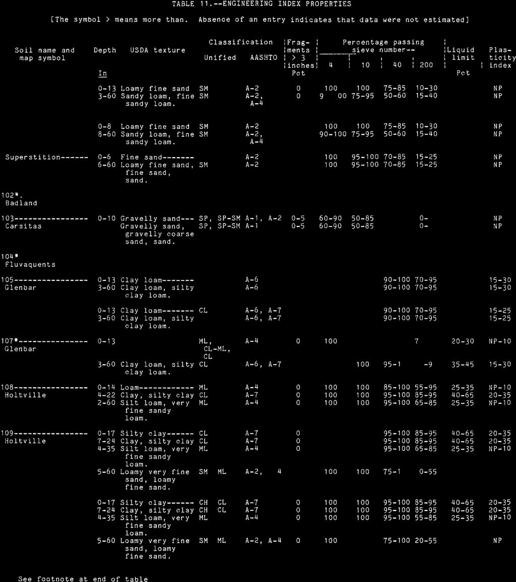
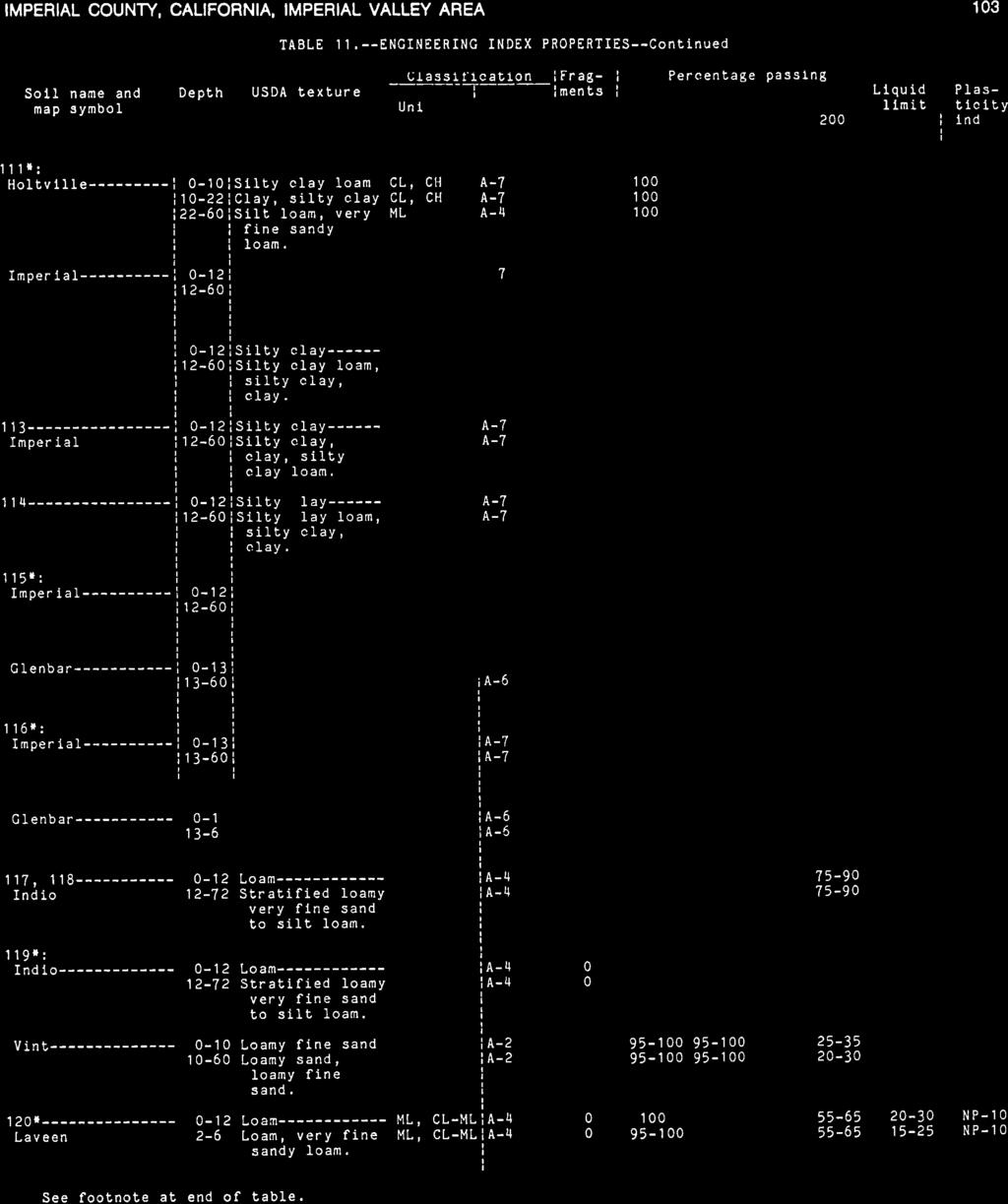
31 Youd, T. L., 2005, Liquefaction-induced flow, lateral spread, and ground oscillation, GSA Abstracts with Programs, Vol. 37, No. 7, p Youd, T. L. and Garris, C. T., 1995, Liquefaction induced ground surface disruption: ASCE Geotechnical Journal, Vol. 121, No. 11. Zimmerman, R. P., 1981, Soil survey of Imperial County, California, Imperial Valley Area: U.S. Dept. of Agriculture Soil Conservation Service, 112 p.
GEOLOGY AND SOILS. This chapter summarizes geologic and geotechnical aspects of the site as they relate to the Project.
 9 GEOLOGY AND SOILS INTRODUCTION This chapter summarizes geologic and geotechnical aspects of the site as they relate to the Project. This chapter utilizes information from the following reports prepared
IV. ENVIRONMENTAL IMPACT ANALYSIS G. GEOLOGY AND SOILS
 IV. ENVIRONMENTAL IMPACT ANALYSIS G. GEOLOGY AND SOILS The following section is a summary of the geotechnical report conducted for the proposed project. The Report of Geotechnical Investigation Proposed
PRELIMINARY GEOLOGICAL AND GEOTECHNICAL HAZARD EVALUATION REPORT
 PRELIMINARY GEOLOGICAL AND GEOTECHNICAL HAZARD EVALUATION REPORT CITIZENS IMPERIAL SOLAR, LLC NILAND, IMPERIAL COUNTY, CALIFORNIA MAY 21, 2018 Prepared for: CITIZENS ENERGY CORPORATION Prepared by: HDR
Impact : Changes to Existing Topography (Less than Significant)
") 4.2 Land Resources 4.2.1 Alternative A Proposed Action Impact 4.2.1-1: Changes to Existing Topography (Less than Significant) Development of the project site would involve grading and other earthwork as
4.2 Land Resources 4.2.1 Alternative A Proposed Action Impact 4.2.1-1: Changes to Existing Topography (Less than Significant) Development of the project site would involve grading and other earthwork as
IV. ENVIRONMENTAL IMPACT ANALYSIS E. GEOLOGY AND SOILS
 IV. ENVIRONMENTAL IMPACT ANALYSIS E. GEOLOGY AND SOILS The following analysis is based on the Geotechnical Investigation Report, Proposed Mid-Rise Multi- Family Residential Development Project Wetherly
ENGINEER S CERTIFICATION OF FAULT AREA DEMONSTRATION (40 CFR )
") PLATTE RIVER POWER AUTHORITY RAWHIDE ENERGY STATION BOTTOM ASH TRANSFER (BAT) IMPOUNDMENTS LARIMER COUNTY, CO ENGINEER S CERTIFICATION OF FAULT AREA DEMONSTRATION (40 CFR 257.62) FOR COAL COMBUSTION RESIDUALS
PLATTE RIVER POWER AUTHORITY RAWHIDE ENERGY STATION BOTTOM ASH TRANSFER (BAT) IMPOUNDMENTS LARIMER COUNTY, CO ENGINEER S CERTIFICATION OF FAULT AREA DEMONSTRATION (40 CFR 257.62) FOR COAL COMBUSTION RESIDUALS
IV. ENVIRONMENTAL IMPACT ANALYSIS E. GEOLOGY AND SOILS
 IV. ENVIRONMENTAL IMPACT ANALYSIS E. GEOLOGY AND SOILS The following section is a summary of the geotechnical report conducted for the Proposed Project. The Geotechnical Engineering Investigation (the
Date: April 2, 2014 Project No.: Prepared For: Mr. Adam Kates CLASSIC COMMUNITIES 1068 E. Meadow Circle Palo Alto, California 94303
 City of Newark - 36120 Ruschin Drive Project Draft Initial Study/Mitigated Negative Declaration Appendix C: Geologic Information FirstCarbon Solutions H:\Client (PN-JN)\4554\45540001\ISMND\45540001 36120
Appendix C - Geotechnical Report. Landmark Consultants, Inc.
 Appendix C - Geotechnical Report Landmark Consultants, Inc. LCI Report No. LP18128 Fault Map Regional Review of the current Alquist-Priolo Earthquake Fault Zone maps (CGS, 2000a) indicates that
IV. ENVIRONMENTAL IMPACT ANALYSIS E. GEOLOGY/SOILS
 IV. ENVIRONMENTAL IMPACT ANALYSIS E. GEOLOGY/SOILS Except where otherwise noted, the following Section is based on the Preliminary Geotechnical Investigation, Proposed Medical Office Buildings and Mixed-Use
IV. ENVIRONMENTAL IMPACT ANALYSIS G. GEOLOGY AND SOILS
 IV. ENVIRONMENTAL IMPACT ANALYSIS G. GEOLOGY AND SOILS INTRODUCTION The information and analysis in this section is based primarily on the following report, which is included in Appendix IV.G of this EIR:
Roy Pyle March 24, 2017 Chief Facilities Planner Contra Costa Community College District 500 North Court Street Martinez, CA 94533
 State of California Natural Resources Agency Edmund G. Brown Jr., Governor Department of Conservation John G. Parrish, Ph.D., State Geologist California Geological Survey 801 K Street MS 12-31 Sacramento,
Converse Consultants Geotechnical Engineering, Environmental & Groundwater Science, Inspection & Testing Services
 Converse Consultants Geotechnical Engineering, Environmental & Groundwater Science, Inspection & Testing Services Ms. Rebecca Mitchell Mt. San Antonio College Facilities Planning & Management 1100 North
IV. ENVIRONMENTAL IMPACT ANALYSIS E. GEOLOGY AND SOILS
 IV. ENVIRONMENTAL IMPACT ANALYSIS E. GEOLOGY AND SOILS INTRODUCTION This section evaluates potential impacts related to geology, including seismicity, and soils associated with development of the proposed
9. GEOLOGY, SOILS, AND MINERALS
 June 28, 2018 Page 9-1 9. GEOLOGY, SOILS, AND MINERALS This EIR chapter describes the existing geological, soil, and mineral conditions in the planning area. The chapter includes the regulatory framework
Setting MOUNTAIN HOUSE NEIGHBORHOODS I AND J INITIAL STUDY 5. ENVIRONMENTAL CHECKLIST 6. GEOLOGY AND SOILS. Issue
 Issue Less Than Significant or No Impact Potential Significant Impact Adequately Addressed in MEIR MEIR Required Additional Review: No Significant Impact Less Than Significant Impact Due to Mitigation
4.5 GEOLOGY AND SEISMICITY
 4.5 GEOLOGY AND SEISMICITY INTRODUCTION This section identifies the potential for geologic and seismic hazards to occur on or near the proposed project site. Issues of concern include suitability of soil
4.5 GEOLOGY AND SOILS
 4.5 GEOLOGY AND SOILS This section addresses the project site geology and soils and analyzes potential changes that would result from development of the Wye Specific Plan project. 4.5.1 Environmental Setting
4.5 GEOLOGY, SOILS AND SEISMICITY
 4.5 This section summarizes information on geology, soils and seismic hazards, and mineral resources in the Truckee area, as well as potential area-wide geologic hazards and regional seismic characteristics
Overview of the Seismic Source Characterization for the Palo Verde Nuclear Generating Station
 Overview of the Seismic Source Characterization for the Palo Verde Nuclear Generating Station Scott Lindvall SSC TI Team Lead Palo Verde SSC SSHAC Level 3 Project Tuesday, March 19, 2013 1 Questions from
SURFACE GEOLOGY AND LIQUEFACTION SUSCEPTIBILITY IN THE INNER RIO GRANDE VALLEY NEAR ALBUQUERQUE, NEW MEXICO
 SURFACE GEOLOGY AND LIQUEFACTION SUSCEPTIBILITY IN THE INNER RIO GRANDE VALLEY NEAR ALBUQUERQUE, NEW MEXICO Keith I. Kelson, Christopher S. Hitchcock, and Carolyn E. Randolph William Lettis & Associates,
GEOLOGY, SOILS, AND SEISMICITY
 4.9 GEOLOGY, SOILS, AND SEISMICITY 4.9.1 Introduction Information about the geological conditions and seismic hazards in the study area was summarized in the FEIR, and was based on the Geotechnical Exploration
Appendix 6A Geologic Information about the Project Area prepared by Ninyo & Moore October 2008
 Appendix 6A Geologic Information about the Project Area prepared by Ninyo & Moore October 2008 Appendix 6A: Geologic Information about the Project Area 6A-1Existing Geologic and Subsurface Conditions
3.8 Geology/Soils. Environmental Setting. Topography. Geology and Soils
 3.8 Geology/Soils This section examines whether implementation of the 2004 Land Use Mobility Elements, Zoning Code Revisions, and Central District Specific Plan the will expose people or structures to
SECTION 4.6 GEOLOGY AND SOILS
 SECTION 4.6 GEOLOGY AND SOILS This section describes federal, state and local regulations applicable to geology and soils. It also describes the environmental setting of the Project area with regard to
IV. ENVIRONMENTAL IMPACT ANALYSIS E. GEOLOGY/SOILS
 IV. ENVIRONMENTAL IMPACT ANALYSIS E. GEOLOGY/SOILS The following discussion is based upon information contained in the Hollywood Redevelopment Plan Amendment EIR and a letter prepared by Geotechnologies,
J.H. Campbell Generating Facility Pond A - Location Restriction Certification Report
 J.H. Campbell Generating Facility Pond A - Location Restriction Certification Report Pursuant to: 40 CFR 257.60 40 CFR 257.61 40 CFR 257.62 40 CFR 257.63 40 CFR 257.64 Submitted to: Consumers Energy Company
Guidelines for Site-Specific Seismic Hazard Reports for Essential and Hazardous Facilities and Major and Special-Occupancy Structures in Oregon
 Guidelines for Site-Specific Seismic Hazard Reports for Essential and Hazardous Facilities and Major and Special-Occupancy Structures in Oregon By the Oregon Board of Geologist Examiners and the Oregon
4.5 GEOLOGY AND SOILS
 4.5.1 Setting 4.5 GEOLOGY AND SOILS a. Regional Geology. The is located in the south central Santa Cruz Mountains in the heart of the Central Coast ranges of California. This is a seismically active region
4.5 GEOLOGY AND SOILS
 4.5 GEOLOGY AND SOILS INTRODUCTION This section describes the City of Coachella s existing geologic, seismic, and soil conditions, and the existing Federal, State, and local regulations with which development
4.7 GEOLOGY AND SOILS
 4.7 GEOLOGY AND SOILS 4.7.1 INTRODUCTION This section describes geology, soils, and seismicity conditions in the vicinity of the project sites and assesses the potential for the project to be affected
Should you have any questions regarding this clarification, please contact the undersigned at or (925)
") October 8, 2015 Revised October 13, 2015 Contra Costa Community College District 500 Court Street Martinez, CA 94553 Attention: Ron Johnson Subject: Clarification of Grading Requirements Diablo Valley
October 8, 2015 Revised October 13, 2015 Contra Costa Community College District 500 Court Street Martinez, CA 94553 Attention: Ron Johnson Subject: Clarification of Grading Requirements Diablo Valley
3E. Geology and Soils
 INTRODUCTION The purpose of this chapter is to evaluate the proposed project s impacts on local geological features and whether it would expose people or structures to adverse geological impacts. Potential
Geology, Soils, and Seismicity
 Section 3.8 Geology, Soils, and Seismicity Introduction This section generally evaluates the effects of the alternatives analyzed in this Supplemental DEIS with regard to geology, soils and seismicity.
Important Concepts. Earthquake hazards can be categorized as:
 Lecture 1 Page 1 Important Concepts Monday, August 17, 2009 1:05 PM Earthquake Engineering is a branch of Civil Engineering that requires expertise in geology, seismology, civil engineering and risk assessment.
3.0 SUMMARY OF POTENTIAL GEOTECHNICAL IMPACTS AND MITIGATION MEASURES
 3.0 SUMMARY OF POTENTIAL GEOTECHNICAL IMPACTS AND MITIGATION MEASURES This section summarizes the principal geotechnical conditions that occur in the project area. The potential impact that each condition
4.6 GEOLOGY, SOILS, AND MINERAL RESOURCES
 4.6 GEOLOGY, SOILS, AND MINERAL RESOURCES This section describes the geology and soil conditions and mineral resources at the Project sites and the general vicinity. This section also analyzes issues that
Project Site. Plate A-3. Soil Survey Map. Project No.: LE15070
 B-4 B-2 B-1 B-5 B-3 N Project No.: LE15070 Boring Location Map Plate A-2 N Project Site Project No.: LE15070 Soil Survey Map Plate A-3 N Project Site Project No.: LE15070 Topographic Map Plate A-4
Mitigation of Liquefaction Potential Using Rammed Aggregate Piers
 ASCE 2011 557 Mitigation of Liquefaction Potential Using Rammed Aggregate Piers R.W. Rudolph, M. ASCE, G.E. 1, B. Serna, M. ASCE, P.E. 2, and T. Farrell, M. ASCE, G.E. 3 1 Principal Consultant, ENGEO,
Section 4.6 Geology and Soils Introduction
 4.6 invisible_toc_marker County of Kern Section 4.6 Geology and Soils 4.6.1 Introduction As described in Chapter 2 of this Supplemental EIR (SEIR), an EIR was previously certified for the Alta Oak Creek
4.10 GEOLOGY, SOILS, AND SEISMICITY
 4.10 GEOLOGY, SOILS, AND SEISMICITY 4.10.1 INTRODUCTION This section describes the geology of the SVRTC and the susceptibility of site soils to seismically induced hazards. Faults in the corridor and past
IV. Environmental Impact Analysis D. Geology
 IV. Environmental Impact Analysis D. Geology 1. Introduction This section evaluates potential geologic hazards and soil conditions associated with the proposed project, including fault rupture, ground
APPENDIX IV.A Geotechnical Study
 City of Los Angeles February 2014 APPENDIX IV.A Geotechnical Study Technical Appendices Museum Square Office Building Draft Environmental Impact Report February 8, 2013 File No. 20477 5757 Wilshire, LLC
SEISMIC HAZARD ANALYSIS. Instructional Material Complementing FEMA 451, Design Examples Seismic Hazard Analysis 5a - 1
 SEISMIC HAZARD ANALYSIS Instructional Material Complementing FEMA 451, Design Examples Seismic Hazard Analysis 5a - 1 Seismic Hazard Analysis Deterministic procedures Probabilistic procedures USGS hazard
IV. ENVIRONMENTAL IMPACT ANALYSIS C. GEOLOGY/SOILS
 IV. ENVIRONMENTAL IMPACT ANALYSIS C. GEOLOGY/SOILS The following section is a summary of the preliminary geotechnical consultation conducted for the Proposed Project. The Report of Geotechnical Engineering
3.3 Geology and Soils
 3.3 Geology and Soils 3.3.1 Introduction and Summary Table 3.3-1 summarizes the geology and soils impacts for the Proposed Project and alternatives. TABLE 3.3-1 Summary of Geology and Soils Impacts 1 Proposed
3.9 GEOLOGY, SOILS, AND MINERALS
 3.9 GEOLOGY, SOILS, AND MINERALS 3.9.1 INTRODUCTION This section covers three closely related topics: geology (including geologic hazards such as earthquakes), soils, and mineral resources. For each of
Basin & Range / Mojave Desert
 Basin & Range / Mojave Desert Basin & Range vs. Great Basin 1 2/20/2016 An overview of the last horst Basin and Range / Mojave Desert Summary: Granitic, volcanic, marine sedimentary, non marine sedimentary,
5. Environmental Analysis
 5.3 GEOLOGY AND SOILS The potential geology and soils impacts associated with development within The Platinum Triangle have been fully analyzed in two previous EIRs, including: Anaheim Stadium Area Master
D.6 Geology and Soils
 This section addresses the Proposed Project and alternatives as they would affect geology and soils. Section D.6.1 provides a description of the environmental setting, and the applicable plans, regulations,
Geotechnical Geologic Coastal Environmental
 Geotechnical Geologic Coastal Environmental 26590 Madison Avenue Murrieta, California 92562 (951) 677-9651 FAX (951) 677-9301 www.geosoilsinc.com April 22, 2014 c/o Matthew Fagan Consulting Services 42011
Earth Mechanics, Inc. Geotechnical & Earthquake Engineering
 TECHNICAL MEMORANDUM EMI PROJECT NO: 13-116 DATE: October 29, 2013 PREPARED FOR: Mr. Todd W. Dudley / AECOM PREPARED BY: SUBJECT: (Raja) S. Pirathiviraj and Lino Cheang / (EMI) Preliminary Foundation Report
Hydrogeological Assessment for Part of Lots 2 and 3, Concession 5, Township of Thurlow, County of Hastings 1.0 INTRODUCTION. 1.
 February 10,2017 25506400 Ontario Ltd. Foxboro, ON Attention: Brad Newbatt Re: Hydrogeological Assessment for Part of Lots 2 and 3, Concession 5, Township of Thurlow, County of Hastings 1.0 INTRODUCTION
4.5 GEOLOGY AND SOILS
 4.5 GEOLOGY AND SOILS This section discusses the proposed project s potential impacts relating to geologic hazards. This section is partially based on the Preliminary Soil Engineering and Geologic Hazards
4.5 GEOLOGY, SOILS, AND SEISMICITY
 4.5 GEOLOGY, SOILS, AND SEISMICITY 4.5 GEOLOGY, SOILS, AND SEISMICITY INTRODUCTION The Geology, Soils, and Seismicity chapter of the EIR describes the geologic and soil characteristics of the (proposed
Downtown Anchorage Seismic Risk Assessment & Land Use Regulations to Mitigate Seismic Risk
 Prepared for: The Municipality of Anchorage Planning Department and the Geotechnical Advisory Commission Downtown Anchorage Seismic Risk Assessment & Land Use Regulations to Mitigate Seismic Risk Prepared
SUPPLEMENTARY INVESTIGATION AND LABORATORY TESTING Aggregate Resource Evaluation Proposed Bernand Quarry San Diego County, California
 October 3, 2 Mr. Mark San Agustin Project No. 28-- Home Land Investments Document No. -92 2239 Curlew Street San Diego, CA 92 SUBJECT: SUPPLEMENTARY INVESTIGATION AND LABORATORY TESTING Aggregate Resource
3.10 GEOLOGY AND SOILS
 3.10 GEOLOGY AND SOILS This section evaluates the potential impacts of the proposed project on geology, soils, and seismic hazards. This evaluation is based on the Preliminary Geotechnical Investigation
4.6 GEOLOGY AND SOILS
 4.6 GEOLOGY AND SOILS The purpose of the Geology and Soils section is to evaluate whether the proposed project would expose people or structures to major geotechnical hazards or substantially contribute
CCR Surface Impoundment Location Restrictions Demonstration. MidAmerican Energy Company, Louisa Generating Station
 CCR Surface Impoundment Location Restrictions Demonstration MidAmerican Energy Company, Louisa Generating Station Final October 17, 2018 CCR Surface Impoundment Location Restrictions Demonstration Prepared
3.6. GEOLOGY and SOILS ENVIRONMENTAL SETTING. Regional Geology
 3.6. GEOLOGY and SOILS 3.6.1. ENVIRONMENTAL SETTING Regional Geology The WSP plan area and Westlands transmission corridors are located in the central San Joaquin Valley, which is part of the Great Valley
5.3 GEOLOGY AND SOILS
 5.3 GEOLOGY AND SOILS SUMMARY The impact analysis presented in this section evaluates project impacts related to geologic hazards. The geotechnical analyses prepared for the project concluded that the
GEOTECHNICAL ENGINEERING INVESTIGATION HANDBOOK Second Edition
 GEOTECHNICAL ENGINEERING INVESTIGATION HANDBOOK Second Edition Roy E. Hunt Taylor & Francis Taylor & Francis Croup Boca Raton London New York Singapore A CRC title, part of the Taylor & Francis imprint,
Sacramento Valley Groundwater Basin, Sutter Subbasin
 Sacramento Valley Groundwater Basin, Sutter Subbasin Groundwater Basin Number: 5-21.62 County: Sutter Surface Area: 234,400 acres (366 square miles) Boundaries and Hydrology The Sutter Subbasin lies in
3.4 GEOLOGY AND SOILS Environmental Setting
 3.4 GEOLOGY AND SOILS This section discusses the existing geologic and soils conditions and evaluates the potential impacts related to geology and soils as a result of the proposed project. This section
NOA ASSESSMENT HARRIS QUARRY MENDOCINO COUNTY, CALIFORNIA TABLE OF CONTENTS
 NOA ASSESSMENT HARRIS QUARRY MENDOCINO COUNTY, CALIFORNIA TABLE OF CONTENTS Introduction... 1 Scope of Services... 1 Project Location and Description... 1 Geologic Setting... 1 Regional Geology... 1 Site
November 16, 2016 Revised August 15, 2017 File No Trammell Crow Company 2221 Rosecrans Avenue, Suite 200 El Segundo, California 90245
 November 16, 2016 Revised August 15, 2017 File No. 21338-01 Trammell Crow Company 2221 Rosecrans Avenue, Suite 200 El Segundo, California 90245 Attention: Karen Shorr Subject: Geotechnical Assessment Site
CHAPTER GEOLOGICALLY HAZARDOUS AREAS Applicability Regulations.
 CHAPTER 19.07 GEOLOGICALLY HAZARDOUS AREAS 19.07.010 Applicability. Geologically hazardous areas may pose a threat to the health and safety of citizens when incompatible development is sited in areas of
KANSAS GEOLOGICAL SURVEY Open File Report LAND SUBSIDENCE KIOWA COUNTY, KANSAS. May 2, 2007
 KANSAS GEOLOGICAL SURVEY Open File Report 2007-22 LAND SUBSIDENCE KIOWA COUNTY, KANSAS Prepared by Michael T. Dealy L.G., Manager, Wichita Operations SITE LOCATION The site was approximately four miles
J. Paul Guyer, P.E., R.A.
 J. Paul Guyer, P.E., R.A. Paul Guyer is a registered mechanical engineer, civil engineer, fire protection engineer and architect with over 35 years experience in the design of buildings and related infrastructure.
George Morgan and JR Morgan
 Studying one Precariously Balanced Rock in the Coyote Mountains using UAVSAR interferograms and the April, 4 th, 2010 El Major- Cucapas Mw 7.2 Earthquake. George Morgan (georgemorgan@cox.net) and JR Morgan
Sacramento Modesto Roseville Pleasanton September 19, 2013 Marcia Medina GHD Inc. 417 Montgomery Street, Suite 700 San Francisco, CA Subject: GE
 Sacramento Modesto Roseville Pleasanton September 19, 2013 Marcia Medina GHD Inc. 417 Montgomery Street, Suite 700 San Francisco, CA 94104 Subject: GEOTECHNICAL REPORT AMENDMENT Stonybrook Creek Crossings
5.5 GEOLOGY, SOILS, AND SEISMICITY
 5.5 GEOLOGY, SOILS, AND SEISMICITY This section of the environmental impact report (EIR) describes the existing geology and soils conditions in the Project area and analyzes the potential for impacts associated
PHYSICAL SCIENCE FINAL
 PHYSICAL SCIENCE FINAL Liquefaction Doreen Wallace, Tesla Grogan, Amber Ward, Erik Garcia, Cinthia Salas, Alexis Albers Liquefaction What is it? Conditions needed How it works Effects of Liquefaction Soil
5. Environmental Analysis
 5.4 This section of the Draft Environmental Impact Report (DEIR) evaluates the potential for implementation of the San Gorgonio Pass Campus Master Plan to impact geological and soil resources. The analysis
NUCLEAR POWER PLANT SITE SELECTION
 NUCLEAR POWER PLANT SITE SELECTION ABDELATY B. SALMAN Ex-Chairman Nuclear Materials Authority, Cairo, Egypt I. Introduction The aim of this article is to present the requirements and characteristics for
ENTERGY WHITE BLUFF PLANT RECYCLE POND A AND RECYCLE POND B DEMONSTRATION OF COMPLIANCE WITH EPA CCR RULE SITING CRITERIA 257.
 ENTERGY WHITE BLUFF PLANT RECYCLE POND A AND RECYCLE POND B DEMONSTRATION OF COMPLIANCE WITH EPA CCR RULE SITING CRITERIA 257.62, FAULT AREAS Prepared for Entergy Arkansas, Inc. PO Box 551 Little Rock,
FRIENDS OF THE EEL RIVER
 FRIENDS OF THE EEL RIVER Working for the recovery of our Wild & Scenic River, its fisheries and communities. Frank Blackett, Regional Engineer Office of Energy Projects Division of Dam Safety and Inspections
Liquefaction induced ground damage in the Canterbury earthquakes: predictions vs. reality
 Bowen, H. J. & Jacka, M. E. () Proc. th NZGS Geotechnical Symposium. Ed. CY Chin, Queenstown Liquefaction induced ground damage in the Canterbury earthquakes: predictions vs. reality H J Bowen & M E Jacka
Interpretive Map Series 24
 Oregon Department of Geology and Mineral Industries Interpretive Map Series 24 Geologic Hazards, Earthquake and Landslide Hazard Maps, and Future Earthquake Damage Estimates for Six Counties in the Mid/Southern
Identification of Lateral Spread Features in the Western New Madrid Seismic Zone J. David Rogers and Briget C. Doyle
 Identification of Lateral Spread Features in the Western New Madrid Seismic Zone J. David Rogers and Briget C. Doyle Department of Geological Engineering University of Missouri-Rolla rogersda@umr.edu doyle@hope.edu
appendix e: geologic and seismic hazards
 appendix e: geologic and seismic hazards CONTENTS: E-2 Fault Rupture E-3 Ground Shaking E-5 Seismic Ground Deformation E-5 Liquification E-6 Seismically Induces Landslide E-6 Landslide Hazard E The following
5.11 Geology and Soils
 5.11 Geology and Soils 5.11 GEOLOGY AND SOILS This section evaluates the geologic and seismic conditions within the City of Azusa and evaluates the potential for geologic hazard impacts associated with
3.3 GEOLOGY AND SOILS Environmental Setting Geologic Conditions
 3.3 GEOLOGY AND SOILS This section describes existing geologic and soil conditions, such as faults or unstable soils, and analyzes potential impacts that could pose hazards for the Fountain Valley Crossings
3.5 Geology and Soils
 3.5 GEOLOGY AND SOILS The following reports have been prepared to analyze the geological impacts of the proposed project and are included in their entirety in Appendices F1 through F7 of this Draft Environmental
IV. ENVIRONMENTAL IMPACT ANALYSIS G. GEOLOGY AND SOILS
 IV. ENVIRONMENTAL IMPACT ANALYSIS G. GEOLOGY AND SOILS The following section is based upon the City of El Segundo General Plan and General Plan EIR and addresses the following geologic issues: soil erosion,
Development of U. S. National Seismic Hazard Maps and Implementation in the International Building Code
 Development of U. S. National Seismic Hazard Maps and Implementation in the International Building Code Mark D. Petersen (U.S. Geological Survey) http://earthquake.usgs.gov/hazmaps/ Seismic hazard analysis
3.10 GEOLOGY/SOILS/SEISMIC/TOPOGRAPHY
 3.10 GEOLOGY/SOILS/SEISMIC/TOPOGRAPHY The information in this section is based on the Geotechnical Final Report (January 2010) and Geotechnical Memorandum for the northern portion of the Study Area (Department
SECTION 3. Housing. EAppendix E GEOLOGIC AND SEISMIC HAZARDS
 SECTION 3 Housing EAppendix E GEOLOGIC AND SEISMIC HAZARDS E-2 Housing Commission Attachment B Appendix E Geologic and Seismic Hazards The following definitions provide a more comprehensive discussion
3.18 GEOLOGY AND SOILS
 3.18 GEOLOGY AND SOILS This section discusses geologic resource concerns as they relate to the environment, public safety, and project design both during construction and after completion of the project.
Evaluation of Geotechnical Hazards
 Evaluation of Geotechnical Hazards by Geoffrey R. Martin Appendix B: Evaluation of Geotechnical Hazards Describes Evaluation Procedures Soil Liquefaction Soil Settlement Surface Fault Rupture Flooding
4.6 GEOLOGY AND SOILS
 The analysis in this Subsection is based, in part, on information contained in four (4) reports prepared by Southern California Geotechnical that assessed the existing surface and subsurface geologic conditions.
3.1 GEOLOGY AND SOILS Introduction Definition of Resource
 3.1 GEOLOGY AND SOILS 3.1.1 Introduction 3.1.1.1 Definition of Resource The geologic resources of an area consist of all soil and bedrock materials. This includes sediments and rock outcroppings in the
Pierce County Department of Planning and Land Services Development Engineering Section
 Page 1 of 7 Pierce County Department of Planning and Land Services Development Engineering Section PROJECT NAME: DATE: APPLICATION NO.: PCDE NO.: LANDSLIDE HAZARD AREA (LHA) GEOLOGICAL ASSESSMENT REPORT
5.5 Geology, Soils and Seismicity
 5.5 Geology, Soils and Seismicity 5.5.1 Introduction Information and recommendations presented in this section were taken from the original East Lake Specific Plan Environmental Impact Report (EIR) [State
4.5 Geology, Soils and Seismicity Environmental Setting Impacts and Mitigation Measures References...4.
 TABLE OF CONTENTS 4.5 Geology, Soils and Seismicity...4.5-1 4.5.1 Environmental Setting...4.5-1 4.5.2 Impacts and Mitigation Measures...4.5-6 4.5.3 References...4.5-9 FIGURES Figure 4.5-1 Active and Potentially
M E M O R A N D U M. Mr. Jonathan K. Thrasher, P.E., Mr. Ian Kinnear, P.E. (FL) PSI
 PSI") M E M O R A N D U M TO: FROM: Mr. Mark Schilling Gulf Interstate Engineering Mr. Jonathan K. Thrasher, P.E., Mr. Ian Kinnear, P.E. (FL) PSI DATE: November 11, 2014 RE: Summary of Findings Geotechnical
M E M O R A N D U M TO: FROM: Mr. Mark Schilling Gulf Interstate Engineering Mr. Jonathan K. Thrasher, P.E., Mr. Ian Kinnear, P.E. (FL) PSI DATE: November 11, 2014 RE: Summary of Findings Geotechnical
4.4 GEOLOGY AND SOILS Existing Conditions
 4.4 GEOLOGY AND SOILS This section evaluates the direct, indirect, short-term, and long-term effects of the proposed Cypress College Facilities Master Plan (proposed project) on geology, soils, and exposure
SOME OBSERVATIONS RELATED TO LIQUEFACTION SUSCEPTIBILITY OF SILTY SOILS
 SOME OBSERVATIONS RELATED TO LIQUEFACTION SUSCEPTIBILITY OF SILTY SOILS Upul ATUKORALA 1, Dharma WIJEWICKREME 2 And Norman MCCAMMON 3 SUMMARY The liquefaction susceptibility of silty soils has not received
Section 3.5 Geology and Soils ENVIRONMENTAL SETTING GEOLOGIC SETTING
 Section 3.5 Geology and Soils This section discusses the environmental setting, existing conditions, regulatory context, and potential impacts of the project in relation to geology and soils. The information