3.5 Geology and Soils
|
|
|
- Moses Alexander
- 5 years ago
- Views:
Transcription
1 3.5 GEOLOGY AND SOILS The following reports have been prepared to analyze the geological impacts of the proposed project and are included in their entirety in Appendices F1 through F7 of this Draft Environmental Impact Report (DEIR): Geotechnical Feasibility Investigation. Prepared by Geotechnical Exploration, Inc. for Sea Breeze Properties, project No , September 23, 2008 (Appendix F1). Geotechnical Investigation, University Place Development, San Marcos, California. Prepared by Leighton and Associated for Lennar Communities, Leighton Project No , September 21, 2004a (Appendix F2). Geotechnical Investigation, University Center, San Marcos, California (bound report). Prepared by Geotechnics Incorporated for American Assets, ICG Job No , Log No R, December 31, 1990 (Appendix F3). Limited Rippability Study (letter report), University Center Site (various parcel numbers), Southwest of State 78 and Twin Oaks Valley Road, San Marcos, California. Prepared by Geotechnical Exploration, Inc., for Sea Breeze Properties, GEI Job No , June 20, 2005 (Appendix F4). Limited Rippability Study (letter report), University Center Site (various parcel numbers), Southwest of State Route 78 and Twin Oaks Valley Road, San Marcos, California. Prepared by Geotechnical Exploration, Inc., for Sea Breeze Properties, GEI Job No , July 20, 2005 (Appendix F5). Preliminary Geologic Reconnaissance (letter report), 17-Acre Property, East Barham Drive, San Marcos, California. Prepared by Southern California Soil & Testing, Inc. (SCS&T) for The McDonald Group, SCS&T No , Report No.1, October 1, 2003 (Appendix F6). Reconnaissance Rippability Study, University Place Development, San Marcos, California (letter report). Rubenfeld Commercial Parcels, West of Shubin Lane, San Marcos, California. Prepared by Geotechnical Exploration, Inc. (GEI), for Scottsdale Investment Management Group, GEI Job No , September 15, 2004 (Appendix F7) Environmental Setting Topography The proposed project site ranges from generally flat, to gently rolling ground to moderately steep hillsides. Elevations range from 550 to 710 feet above mean sea level (AMSL), with the highest point being on a single hill which occupies the southwest portion of the site. Figure depicts the existing topography on the project site and in the project vicinity. University District Specific Plan City of San Marcos
2 Soils The project site is located in the Peninsular Ranges geomorphic province of southern California, which is characterized by granitic crystalline rocks of the Cretaceous-age southern California batholith. Based on site surveys, field mapping, subsurface excavations, and review of existing literature and published San Diego soil survey. The project site substrata includes: Undocumented Artificial Fill (Afu), Quaternary Colluvium (Qal/Qcol) deposits on top of Cretaceous Granite (Kgr) bedrock. Soils are shown on Figure Undocumented Artificial Fill (Afu) The majority of the undocumented fill soils are in a small area in the central portion of the site, along Barham Drive, and in minor amounts at various other locations within site. The undocumented fill soils were likely placed on the site during previous site grading associated with construction of Barham Drive. Based on exploratory borings, these undocumented fill soils are expected to be up to approximately 8 feet thick in the central and southern portions of the site and range from 1 to 4 feet thick in other locations on the site. Colluvium (Qal/Qcol) Colluvial soils encountered overlying the entire site. Colluvium generally consists of red-brown to orange-brown, damp to moist, medium dense to very dense, silty sand to silty clayey sand that appeared to be massive and residual highly weathered bedrock. Geotechnical analysis indicates that with the exception of near-surface soils, the colluvium encountered in can be considered competent. The upper four feet of the colluvial soils were slightly porous and dry and are not considered suitable for support of improvements or additional fill. Cretaceous Granitic Rock (Kgr) The western portion of the project site is underlain by bedrock material consisting of Cretaceous-aged Granitic rock encountered at depths ranging from 7 to 23 feet. This material generally excavated to an orange brown to grayish brown, silty medium to coarse sand with clay. Sample drillings indicated granitic material at 2 to 4 feet thick, which could indicate localized residual boulders that may exist within the decomposed granite mass. Soils derived from the underlain material and bedrock on the project site include: Placentia sandy loam, (2 to 9 percent slopes), Grangeville fine sandy loam (0 to 2 percent slopes), Cieneba coarse sandy loam, (5 to 15 percent slopes, eroded), Exchequer rocky silt loam (9 to 30 percent slopes), Escondido very fine sandy loam, (9 to 15 percent slopes), Escondido very fine sandy loam, (15 to 30 percent slopes). These soils range from slow to rapid for runoff and slight to high for erosional qualities. Cieneba coarse sandy loam (C1D1), 5 to 15 percent slopes, eroded: The Cieneba series consists of excessively drained, very shallow to shallow coarse sandy loams. This soil form in material weathered in place from granitic rock, on rolling to hilly areas. Runoff is slow to medium, the erosion hazard slight to moderate, and the shrink-swell behavior is low. University District Specific Plan City of San Marcos


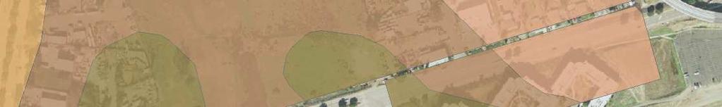
3 Project Area ExE Exchequer Rocky Silt Loam CID2 Offsite Area Cieneba Course Sandy Loam FaC Fallbrook Sandy Loam Grangeville Fine Sandy Loam San Marcos Blvd EsE2 Escondido Very Fine Sandy Loam PeC Placentia Sandy Loam EsC Escondido Very Fine Sandy Loam VsC Visalia Sandy Loam EsD2 Escondido Very Fine Sandy Loam PeC 78 San Marcos Creek ClD2 ClD2 Source: SSURGO; 2008 Eagle Aerials; 2008 G:\Projects\200595_SANMARCOS\67907_HEART\map_docs\mxd\EIR\ \Fig3.5-1Soils.mxd Last Updated : ² ExE EsE ,600 Feet EsD2 EsD2 EsC ExE ClD2 Twin Oaks Valley Rd. VsC PeC VsC FaC Soils FIGURE University District City of San Marcos Environmental Impact Report
4
5 Escondido very fine sandy loam (EsD2), 9 to 15 percent slopes: This soil series in consists of moderately deep to deep, well-drained very fine sandy loams that form in material weathered in place from metamorphosed sandstone. The depth to hard metamorphic rock ranges from 20 to 35 inches. Permeability is moderate, with the average holding capacity 3 to 5.5 inches. Runoff is medium, the hazard of erosion moderate, and the shrink-swell behavior is low. Escondido very fine sandy loam (9EsE2), 15 to 30 percent slopes. This soil series in consists of moderately deep to deep, well-drained very fine sandy loams that form in material weathered in place from metamorphosed sandstone. This soil is moderately steep and is 20 to 34 inches deep over rock. Runoff is medium to rapid, the erosion hazard is moderate to high, and the shrink-swell behavior is low. Exchequer rocky silt loam (ExE), 9 to 30 percent slopes: This soil series consists of shallow and very shallow, well-drained silt loams that formed in material weathered from hard metabasic rock. This soil is on ridges and foot slopes, is strongly sloping to moderately step. These soils are on mountainous uplands and have slopes of 9 to 70 percent, with elevation ranges from 400 to 3,000 feet. Runoff is medium to rapid, erosion hazard is moderate to high, and the shrink-swell behavior is low. Grangeville fine sandy loam (), 0 to 2 percent slopes: This soil series consists of somewhat poorly drained, very deep fine sandy loams derived from granitic alluvium, formed on alluvial fans and alluvial plains with slope averaging 2 percent. Runoff is very slow, erosion hazard slight, and the shrink-swell behavior is low. Placentia sandy loam (PeC), 2 to 9 percent slopes: This soil series consists of moderately well drained sandy loams that have a sandy clay subsoil, formed in granitic alluvium. Permeability is very slow in the subsoil. Runoff is slow to medium, erosion hazard slight to moderate, and the shrink-swell behavior is high. Seismicity Seismic hazards that occur as a result of the presence of faults capable of generating earthquakes are: (1) strong ground motion/shaking; (2) ground rupture; (3) liquefaction; and (4) landslides. Ground motion occurs when faults rupture at depth where pressures are high and result in earthquakes. Ground rupture occurs when the fault ruptures at depth and movement along the fault propagates to the ground surface resulting in vertical and/or lateral displacement. Liquefaction and landslides are the result of ground motions where localized surface and subsurface ground unit conditions are susceptible to collapse or flow. The site can be considered to lie within a seismically active region, as can all of Southern California. Most seismic hazards on a site are a consequence of ground shaking caused by events on distant active faults. Seven active faults are located within 63 miles (100 kilometers) of the site. The nearest active regional fault is the offshore segment of the Rose Canyon Fault Zone located approximately 13.2 miles west of the site. There are no known active faults either on or adjacent to the project site Thresholds of Significance As defined in Appendix G of the CEQA Guidelines, project impacts to geological resources are considered significant if any of the following occur: University District Specific Plan City of San Marcos
6 a) Expose people or structures to potential substantive adverse effects, including the risk of loss, injury, or death involving: i) Rupture of a known earthquake fault, as delineated on the most recent Alquist-Priolo Earthquake Fault Zoning Map issued by the State Geologist for the area or based on other substantial evidence of a known fault? Refer to Division of Mines and Geology Special Publication 42. ii) Strong seismic ground shaking? iii) Seismic related ground failure, including liquefaction? iv) Landslides? b) Result in substantial soil erosion or the loss of topsoil? c) Be located on a geologic unit or soil that is unstable, or that would become unstable as a result of the project, and potentially result in onsite or offsite landslide, lateral spreading, subsidence, liquefaction or collapse? d) Be located on expansive soil, as defined in Table 18-1-B of the Uniform Building code (1994), creating substantial risks to life or property? e) Have soils incapable of adequately supporting the use of septic tanks or alternative water disposal system where sewers are not available for the disposal of waste water? Project Impacts Seismicity The proposed project site is located in a seismically-active area, but there are no known active faults crossing immediately adjacent to the project site, as illustrated in Figure Most seismic hazards at the site are a consequence of ground shaking caused by events on distant, active faults. Shallow ground ruptures are considered unlikely as there are no active faults mapped crossing the site, and the site is not located within a mapped Alquist-Priolo Earthquake Fault Zone as shown on United States Geological Survey (USGS) and California Geological Survey (CGS) maps. Lurching and ground cracking are a possibility as a result of a significant seismic event on a nearby active fault. Future development on the project site would be subject to the requirements of the Uniform Building Code (UBC) for Zone 4 for resistance to seismic shaking. In addition, the proposed project will be constructed in accordance with other UBC criteria, current seismic design specifications of the Structural Engineers Association of California, other applicable regulations, ongoing site-specific geotechnical investigations, and all applicable requirements of the State of California Occupational Safety and Health Administration (Cal/OSHA). Therefore, impacts from seismic ground shaking would be less than significant. Liquefaction Liquefaction is a process in which soil grains in a saturated sandy deposit lose contact due to earthquakes or other sources of ground shaking. Granular soils underlain by near surface ground water table are most susceptible to liquefaction, while the stability of most clayey material are not adversely affected by vibratory motion. Based on the geological studies the liquefaction hazard of the relatively thin and dense University District Specific Plan City of San Marcos


7 Fallbrook 5 Vista Valley Center Oceanside Carlsbad 15 San Marcos Escondido Source: Data Source; YEAR G:\Projects\200595_SANMARCOS\67907_HEART\map_docs\mxd\EIR\ \Fig3.5-2Faults.mxd Last Updated : $ 5 Encinitas Solana Beach Del Mar Miles Project Location Poway La Mesa 78 Fault by Age Historic Santee Holocene Late Quaternary Quaternary Pre-Quaternary Ramona Fault by Type El Cajon Known, w/ Surface Expression Known, w/o Surface Expression Assumed Faults FIGURE University District City of San Marcos Environmental Impact Report
8
9 colluvial soils, Santiago Formation and granitic rock underlying the site are typically not susceptible to liquefaction due to such factors as density and grain size distribution. Based on the soil type on the project site and lightly occurring groundwater impacts from liquefaction would be less than significant. Landslides Landslides are mass movements of the ground that include rock falls, relatively shallow slumping and sliding of soil, and deeper rotational or transitional movement of soil or rock. The proposed project site ranges in elevation from approximately 550 to 710 feet AMSL. Topography throughout the site is generally hilly with flatter areas associated with San Marcos Creek in the western portion and with a swale located in the eastern portion. The eastern half of the site is developed and slopes upward to the east. The project site is located in the Peninsular Ranges geomorphic province of southern California. The site is characterized by bedrock material consisting of Cretaceous-aged granitic rock encountered at depths ranging from 7 to 23 feet. The soils derived from the underlain material and bedrock includes: very fine to coarse sandy loams, rocky silt loams. Based on the underlying bedrock and the soil composition of the project site, impacts due to landslides would be considered less than significant. Erosion/Loss of Top Soil As identified above, the six different soil materials on the project site range from slight to high potential for erosion. The majority of the site occupies soil with slight to moderate erosional qualities. Since the slopes would be constructed using fill material generated from the cut portions of the site, many of the constructed fill slopes would be prone to superficial erosion, especially during periods of rain. The implementation of a project-specific Erosion Control Plan and a Storm Water Pollution Prevention Plan (SWPPP) in accordance with the California State Water Resources Control Board Order No DWQ, NPDES General Permit No. CAS as identified in the Preliminary Geotechnical Investigation. The SWPPP would comply with Best Available Technology (BAT) and Best Conventional Pollutant Control Technology to reduce or eliminate storm water pollution from areas of construction activity. During construction, soil erosion would be controlled and would reduce any erosional impacts to less than significant. Alternative Wastewater Disposal The proposed project would not be serviced by either septic tanks or an alternative wastewater disposal system. Vallecitos Water District provides water, wastewater, and water reclamation services to the city of San Marcos. Sewer infrastructure within the proposed project area would connect to existing Vallecitos Water District sewer facilities. Therefore, no impacts to the project site would occur from the addition of alternative wastewater disposal systems. Soil Instability - Expansive Soils The geologic units located on the project site consist predominantly of very-fine to course, well-drained sandy loams. These soils have a low potential for expansion. While the surface soils on the site may have relatively lower levels of cohesion, the underling materials (consisting of granitic bedrock) are substantially more stable. The project site occupies soils that have low shrink-swell qualities that would indicate a low potential for soil expansion. The addition of compacted engineered fill to developed portions of the site, lateral spreading, liquefaction, subsidence, or collapse are not expected to occur. University District Specific Plan City of San Marcos
10 Development on this type of soil would not create substantial risks to life or property. Therefore, impacts would be less than significant. Soil Instability Compressible soils A portion of the site area is underlain by potentially compressible soils. A portion of the site area is underlain by potentially undocumented fill, compressible alluvial, and colluvial soils which will require removal and replacement with properly compacted fill during the construction process as defined by the UBC/California Building Code (CBC). This represents a potentially significant impact CUMULATIVE IMPACTS Potential impacts related to geologic, seismic, and soils hazards are all site specific. All cumulative development would be subject to similar requirements to those imposed and implemented for the proposed project and would be required to adhere to applicable regulations, standards, and procedures. The proposed project would not result in significant cumulative impacts in regards to geology and soils Mitigation Measures GEO-1 For the portions of the project site that are underlain by potentially compressible soils, the soil shall be removed and replaced with properly compacted fill during the construction process as defined by the UBC/CBC. The fill material removed from the project site shall be tested and evaluated to meet design requirements Conclusion Based upon the analysis presented in Sections and 3.5.4, impact associated with seismicity, liquefaction, landslides, erosion/loss of topsoil, and expansive soils were determined to be less than significant. Impacts related to alternative disposal (e.g., septic) was determined to not have an impact. A potentially significant impact related to compressible soils was identified. A portion of the site area is underlain by potentially compressible soils. A portion of the site area is underlain by potentially undocumented fill, compressible alluvial, and colluvial soils which will require removal and replacement with properly compacted fill during the construction process as defined by the UBC/CBC. This will reduce the impact to below a level of significance. University District Specific Plan City of San Marcos
GEOLOGY AND SOILS. This chapter summarizes geologic and geotechnical aspects of the site as they relate to the Project.
 9 GEOLOGY AND SOILS INTRODUCTION This chapter summarizes geologic and geotechnical aspects of the site as they relate to the Project. This chapter utilizes information from the following reports prepared
IV. ENVIRONMENTAL IMPACT ANALYSIS G. GEOLOGY AND SOILS
 IV. ENVIRONMENTAL IMPACT ANALYSIS G. GEOLOGY AND SOILS The following section is a summary of the geotechnical report conducted for the proposed project. The Report of Geotechnical Investigation Proposed
IV. ENVIRONMENTAL IMPACT ANALYSIS E. GEOLOGY AND SOILS
 IV. ENVIRONMENTAL IMPACT ANALYSIS E. GEOLOGY AND SOILS The following section is a summary of the geotechnical report conducted for the Proposed Project. The Geotechnical Engineering Investigation (the
IV. ENVIRONMENTAL IMPACT ANALYSIS E. GEOLOGY/SOILS
 IV. ENVIRONMENTAL IMPACT ANALYSIS E. GEOLOGY/SOILS Except where otherwise noted, the following Section is based on the Preliminary Geotechnical Investigation, Proposed Medical Office Buildings and Mixed-Use
IV. ENVIRONMENTAL IMPACT ANALYSIS E. GEOLOGY AND SOILS
 IV. ENVIRONMENTAL IMPACT ANALYSIS E. GEOLOGY AND SOILS The following analysis is based on the Geotechnical Investigation Report, Proposed Mid-Rise Multi- Family Residential Development Project Wetherly
5.11 Geology and Soils
 5.11 Geology and Soils 5.11 GEOLOGY AND SOILS This section evaluates the geologic and seismic conditions within the City of Azusa and evaluates the potential for geologic hazard impacts associated with
Setting MOUNTAIN HOUSE NEIGHBORHOODS I AND J INITIAL STUDY 5. ENVIRONMENTAL CHECKLIST 6. GEOLOGY AND SOILS. Issue
 Issue Less Than Significant or No Impact Potential Significant Impact Adequately Addressed in MEIR MEIR Required Additional Review: No Significant Impact Less Than Significant Impact Due to Mitigation
4.5 GEOLOGY AND SOILS
 4.5 GEOLOGY AND SOILS This section addresses the project site geology and soils and analyzes potential changes that would result from development of the Wye Specific Plan project. 4.5.1 Environmental Setting
IV. ENVIRONMENTAL IMPACT ANALYSIS E. GEOLOGY AND SOILS
 IV. ENVIRONMENTAL IMPACT ANALYSIS E. GEOLOGY AND SOILS INTRODUCTION This section evaluates potential impacts related to geology, including seismicity, and soils associated with development of the proposed
IV. ENVIRONMENTAL IMPACT ANALYSIS G. GEOLOGY AND SOILS
 IV. ENVIRONMENTAL IMPACT ANALYSIS G. GEOLOGY AND SOILS The following section is based upon the City of El Segundo General Plan and General Plan EIR and addresses the following geologic issues: soil erosion,
IV. ENVIRONMENTAL IMPACT ANALYSIS G. GEOLOGY AND SOILS
 IV. ENVIRONMENTAL IMPACT ANALYSIS G. GEOLOGY AND SOILS INTRODUCTION The information and analysis in this section is based primarily on the following report, which is included in Appendix IV.G of this EIR:
9. GEOLOGY, SOILS, AND MINERALS
 June 28, 2018 Page 9-1 9. GEOLOGY, SOILS, AND MINERALS This EIR chapter describes the existing geological, soil, and mineral conditions in the planning area. The chapter includes the regulatory framework
3.10 GEOLOGY AND SOILS
 3.10 GEOLOGY AND SOILS This section evaluates the potential impacts of the proposed project on geology, soils, and seismic hazards. This evaluation is based on the Preliminary Geotechnical Investigation
4.5 GEOLOGY AND SEISMICITY
 4.5 GEOLOGY AND SEISMICITY INTRODUCTION This section identifies the potential for geologic and seismic hazards to occur on or near the proposed project site. Issues of concern include suitability of soil
3.8 Geology/Soils. Environmental Setting. Topography. Geology and Soils
 3.8 Geology/Soils This section examines whether implementation of the 2004 Land Use Mobility Elements, Zoning Code Revisions, and Central District Specific Plan the will expose people or structures to
IV. ENVIRONMENTAL IMPACT ANALYSIS E. GEOLOGY/SOILS
 IV. ENVIRONMENTAL IMPACT ANALYSIS E. GEOLOGY/SOILS The following discussion is based upon information contained in the Hollywood Redevelopment Plan Amendment EIR and a letter prepared by Geotechnologies,
3E. Geology and Soils
 INTRODUCTION The purpose of this chapter is to evaluate the proposed project s impacts on local geological features and whether it would expose people or structures to adverse geological impacts. Potential
Impact : Changes to Existing Topography (Less than Significant)
") 4.2 Land Resources 4.2.1 Alternative A Proposed Action Impact 4.2.1-1: Changes to Existing Topography (Less than Significant) Development of the project site would involve grading and other earthwork as
4.2 Land Resources 4.2.1 Alternative A Proposed Action Impact 4.2.1-1: Changes to Existing Topography (Less than Significant) Development of the project site would involve grading and other earthwork as
4.6 GEOLOGY AND SOILS
 The analysis in this Subsection is based, in part, on information contained in four (4) reports prepared by Southern California Geotechnical that assessed the existing surface and subsurface geologic conditions.
5. Environmental Analysis
 5.3 GEOLOGY AND SOILS The potential geology and soils impacts associated with development within The Platinum Triangle have been fully analyzed in two previous EIRs, including: Anaheim Stadium Area Master
3.1.3 Geology and Soils
 3.1.3 Geology and Soils This section addresses the potential geology and soils impacts associated with implementation of The Villages Escondido Country Club Project (Project). The section describes the
GEOLOGY, SOILS, AND SEISMICITY
 4.9 GEOLOGY, SOILS, AND SEISMICITY 4.9.1 Introduction Information about the geological conditions and seismic hazards in the study area was summarized in the FEIR, and was based on the Geotechnical Exploration
4.5 GEOLOGY AND SOILS
 4.5.1 Setting 4.5 GEOLOGY AND SOILS a. Regional Geology. The is located in the south central Santa Cruz Mountains in the heart of the Central Coast ranges of California. This is a seismically active region
ENGINEER S CERTIFICATION OF FAULT AREA DEMONSTRATION (40 CFR )
") PLATTE RIVER POWER AUTHORITY RAWHIDE ENERGY STATION BOTTOM ASH TRANSFER (BAT) IMPOUNDMENTS LARIMER COUNTY, CO ENGINEER S CERTIFICATION OF FAULT AREA DEMONSTRATION (40 CFR 257.62) FOR COAL COMBUSTION RESIDUALS
PLATTE RIVER POWER AUTHORITY RAWHIDE ENERGY STATION BOTTOM ASH TRANSFER (BAT) IMPOUNDMENTS LARIMER COUNTY, CO ENGINEER S CERTIFICATION OF FAULT AREA DEMONSTRATION (40 CFR 257.62) FOR COAL COMBUSTION RESIDUALS
Section 4.6 Geology and Soils Introduction
 4.6 invisible_toc_marker County of Kern Section 4.6 Geology and Soils 4.6.1 Introduction As described in Chapter 2 of this Supplemental EIR (SEIR), an EIR was previously certified for the Alta Oak Creek
3.4 Geology/Soils/Paleontological Resources
 Section 3.4 Geology, Soils, and Paleontological Resources This section evaluates potential geology and soils impacts, and also paleontological impacts. The analysis is based on a preliminary geotechnical
4.6 GEOLOGY AND SOILS
 LSA ASSOCIATES, INC. MARCH 2008 FINAL ENVIRONMENTAL IMPACT REPORT YUCCA VALLEY RETAIL SPECIFIC PLAN The purpose of the Geology and Soils section is to evaluate whether the proposed project would create
Converse Consultants Geotechnical Engineering, Environmental & Groundwater Science, Inspection & Testing Services
 Converse Consultants Geotechnical Engineering, Environmental & Groundwater Science, Inspection & Testing Services Ms. Rebecca Mitchell Mt. San Antonio College Facilities Planning & Management 1100 North
4.9 GEOLOGY AND SOILS
 4.9 GEOLOGY AND SOILS 4.9.1 EXISTING CONDITIONS TOPOGRAPHY AND RELIEF Zone 40 is located in the central portion of Sacramento County. The topography of the county is represented by three physiographic
2.5. Geology and Soils
 2.5. Geology and Soils This section addresses potential impacts to geology and soils impacts may result from construction and/or operation of the Safari Highlands Ranch (SHR) project. The following discussion
4.5 Geology and Soils
 Environmental Impact Analysis Geology and Soils 4.5 Geology and Soils This section assesses potential impacts related to geologic and soil hazards. 4.5.1 Setting a. Topography and Geology San Leandro is
4.5 GEOLOGY, SOILS AND SEISMICITY
 4.5 This section summarizes information on geology, soils and seismic hazards, and mineral resources in the Truckee area, as well as potential area-wide geologic hazards and regional seismic characteristics
4.6 GEOLOGY AND SOILS
 4.6 GEOLOGY AND SOILS The purpose of the Geology and Soils section is to evaluate whether the proposed project would expose people or structures to major geotechnical hazards or substantially contribute
5.9 Geology and Soils
 5.9 Geology and Soils 5.9 GEOLOGY AND SOILS This section evaluates the geologic and seismic conditions within the City of Azusa and evaluates the potential for geologic hazard impacts associated with
5.5 Geology and Soils
 5.5 Geology and Soils The analysis in this section of the EIR addresses the potential impacts associated with geology and soils that may occur due to implementation of the proposed Collier Park Renovations
5. Environmental Analysis
 5.4 This section of the Draft Environmental Impact Report (DEIR) evaluates the potential for implementation of the San Gorgonio Pass Campus Master Plan to impact geological and soil resources. The analysis
4.2.5 Geology and Soils
 4.2.5 Geology and Soils Introduction This section evaluates potential geologic, seismic, and soils (geological) impacts associated with construction and operation of the proposed (WVLCSP) project. Specifically,
4.5 GEOLOGY AND SOILS
 4.5 GEOLOGY AND SOILS This section discusses the proposed project s potential impacts relating to geologic hazards. This section is partially based on the Preliminary Soil Engineering and Geologic Hazards
3.0 SUMMARY OF POTENTIAL GEOTECHNICAL IMPACTS AND MITIGATION MEASURES
 3.0 SUMMARY OF POTENTIAL GEOTECHNICAL IMPACTS AND MITIGATION MEASURES This section summarizes the principal geotechnical conditions that occur in the project area. The potential impact that each condition
4.5 GEOLOGY AND SOILS
 4.5 GEOLOGY AND SOILS This section discusses the Project s potential impacts relating to geologic hazards. This section is partially based on the Geotechnical Engineering Report included in Appendix E.
IV. ENVIRONMENTAL IMPACT ANALYSIS F. GEOLOGY AND SOILS
 IV. ENVIRONMENTAL IMPACT ANALYSIS F. GEOLOGY AND SOILS INTRODUCTION This section of the DEIR evaluates potential impacts to the project site s geologic environment that may result from implementation of
IV. ENVIRONMENTAL IMPACT ANALYSIS C. GEOLOGY/SOILS
 IV. ENVIRONMENTAL IMPACT ANALYSIS C. GEOLOGY/SOILS The following section is a summary of the preliminary geotechnical consultation conducted for the Proposed Project. The Report of Geotechnical Engineering
3.6 Geology, Soils, and Seismicity
 0 0... Existing Conditions... Regulatory Setting Federal There are no federal laws, regulations, or standards related to geology and soils that are applicable to the Proposed Project. State Alquist-Priolo
4.6 GEOLOGY AND SOILS
 4.6 GEOLOGY AND OIL 4.6.1 ummary able 4.6-1 summarizes the identified environmental impacts, proposed mitigation measures, and residual impacts of the proposed project with regard to geology and soils.
Geology, Soils, and Seismicity
 Section 3.8 Geology, Soils, and Seismicity Introduction This section generally evaluates the effects of the alternatives analyzed in this Supplemental DEIS with regard to geology, soils and seismicity.
4.6 GEOLOGY, SOILS, AND MINERAL RESOURCES
 Ascent Environmental 4.6 GEOLOGY, SOILS, AND MINERAL RESOURCES This section of the EIR describes the existing geology, soils, and mineral resources at and in the vicinity of the project site and analyzes
5.6 GEOLOGY, SOILS, AND SEISMICITY
 This section discusses the geology of the Project area and general vicinity and analyzes hazards related to geology and soils, such as potential exposure of people and property to geologic hazards, landform
5.5 GEOLOGY/SOILS EXISTING CONDITIONS. Regulatory Setting
 5.5 GEOLOGY/SOILS This section describes existing environmental conditions related to geology and soils in the project area, including W-19, the disposal site, and beach placement sites proposed as part
3.3 GEOLOGY AND SOILS Environmental Setting Geologic Conditions
 3.3 GEOLOGY AND SOILS This section describes existing geologic and soil conditions, such as faults or unstable soils, and analyzes potential impacts that could pose hazards for the Fountain Valley Crossings
4.5 Geology, Soils and Seismicity Environmental Setting Impacts and Mitigation Measures References...4.
 TABLE OF CONTENTS 4.5 Geology, Soils and Seismicity...4.5-1 4.5.1 Environmental Setting...4.5-1 4.5.2 Impacts and Mitigation Measures...4.5-6 4.5.3 References...4.5-9 FIGURES Figure 4.5-1 Active and Potentially
4.L GEOLOGY, SOILS, AND SEISMICITY 4.L.1 INTRODUCTION
 4.L GEOLOGY, SOILS, AND SEISMICITY 4.L.1 INTRODUCTION This section addresses potential environmental effects of the proposed TOD Plan for Downtown Inglewood and Fairview Heights related to geology, soils,
4.4 GEOLOGY AND SOILS
 4.4 GEOLOGY AND SOILS SUMMARY This section describes the existing geologic and soils conditions on the project site, and the potential for geotechnical hazards to affect the Via Princessa East Extension
2. Initial Summary of Preliminary Expert Opinion of Converse and Psomas Reports
 UNITED WALNUT TAXPAYERS PRELIMINARY REVIEW OF NEGATIVE GEOTECHNICAL AND GEOLOGICAL ASPECTS OF CONSTRUCTING EARTHFILL PAD FOR A SOLAR FARM ON THE WEST PARCEL - DRAFT 1. Introduction A licensed Engineering
3.6 GEOLOGY AND SOILS
 3.6 GEOLOGY AND SOILS This section of the EIR examines the regional and local geologic and soil characteristics of the project site and surrounding area. For the lagoon enhancement component, the analysis
8.0 GEOLOGY AND SOILS
 This section describes the current geologic and soil conditions at each of the Dollar General project sites and analyzes issues related to geology and soils. Geotechnical studies have been prepared for
4.5 Geology and Soils
 4.5 Geology and Soils This section evaluates potential geology and soils impacts that could affect or result from the future development consistent with the Encinitas Housing Element Update (HEU). Information
3.4 GEOLOGY AND SOILS Environmental Setting
 3.4 GEOLOGY AND SOILS This section discusses the existing geologic and soils conditions and evaluates the potential impacts related to geology and soils as a result of the proposed project. This section
Section 3.5 Geology and Soils ENVIRONMENTAL SETTING GEOLOGIC SETTING
 Section 3.5 Geology and Soils This section discusses the environmental setting, existing conditions, regulatory context, and potential impacts of the project in relation to geology and soils. The information
Section 4.6 Geology and Soils
 Section 4.6 Geology and Soils 4.6.1 Introduction Section 4.6 Geology and Soils This section describes effects on geology and soils that would be caused by implementation of the proposed and Jawbone Wind
5.4 GEOLOGY AND SOILS
 5.4 GEOLOGY AND SOILS INTRODUCTION This section describes the geology and soils of the project site and analyzes issues such as potential exposure of people and future improvements to geologic and seismic
4.5 GEOLOGY AND SOILS
 4.5 GEOLOGY AND SOILS Geologic and soil conditions on campus are generally as described in the 1989 LRDP EIR. Relevant information from the Earth Resources section (pages 147-157) in Volume I of that document
4.5 GEOLOGY, SOILS, AND SEISMICITY
 4.5 GEOLOGY, SOILS, AND SEISMICITY 4.5 GEOLOGY, SOILS, AND SEISMICITY INTRODUCTION The Geology, Soils, and Seismicity chapter of the EIR describes the geologic and soil characteristics of the (proposed
4.4 GEOLOGY AND SOILS Existing Conditions
 4.4 GEOLOGY AND SOILS This section evaluates the direct, indirect, short-term, and long-term effects of the proposed Cypress College Facilities Master Plan (proposed project) on geology, soils, and exposure
5.3 GEOLOGY AND SOILS
 5.3 GEOLOGY AND SOILS SUMMARY The impact analysis presented in this section evaluates project impacts related to geologic hazards. The geotechnical analyses prepared for the project concluded that the
3.5 Geology, Soils, and Paleontology
 3.5 Geology, Soils, and Paleontology Overview of Impacts The analytical approach taken by this Subsequent EIR is described in Section 3.0 (Introduction to Environmental Analysis). The following section
IV. ENVIRONMENTAL IMPACT ANALYSIS E. GEOLOGY AND SOILS
 IV. ENVIRONMENTAL IMPACT ANALYSIS E. GEOLOGY AND SOILS INTRODUCTION This section of the (Draft EIR) evaluates potential geology and soils impacts associated with development of the proposed (proposed Project
2.10 Geology/Soils/Seismic/Topography
 2.10 Geology/Soils/Seismic/Topography 2.10.1 Regulatory Setting This section discusses geology, soils, and seismic concerns as they relate to public safety and project design. Earthquakes are prime considerations
IV. Environmental Impact Analysis D. Geology
 IV. Environmental Impact Analysis D. Geology 1. Introduction This section evaluates potential geologic hazards and soil conditions associated with the proposed project, including fault rupture, ground
5.5 Geology, Soils and Seismicity
 5.5 Geology, Soils and Seismicity 5.5.1 Introduction Information and recommendations presented in this section were taken from the original East Lake Specific Plan Environmental Impact Report (EIR) [State
3.9 GEOLOGY, SOILS, AND MINERALS
 3.9 GEOLOGY, SOILS, AND MINERALS 3.9.1 INTRODUCTION This section covers three closely related topics: geology (including geologic hazards such as earthquakes), soils, and mineral resources. For each of
Roy Pyle March 24, 2017 Chief Facilities Planner Contra Costa Community College District 500 North Court Street Martinez, CA 94533
 State of California Natural Resources Agency Edmund G. Brown Jr., Governor Department of Conservation John G. Parrish, Ph.D., State Geologist California Geological Survey 801 K Street MS 12-31 Sacramento,
4.5 GEOLOGY AND SOILS
 4.5 GEOLOGY AND SOILS INTRODUCTION This section describes the existing geological and soil resources within the City, identifies the regulatory framework with respect to regulations that address geological
CHAPTER GEOLOGICALLY HAZARDOUS AREAS Applicability Regulations.
 CHAPTER 19.07 GEOLOGICALLY HAZARDOUS AREAS 19.07.010 Applicability. Geologically hazardous areas may pose a threat to the health and safety of citizens when incompatible development is sited in areas of
No comments related to geology and soils were received during public review of the Notice of Preparation.
 Ascent Environmental 4.5 Geology and Soils GEOLOGY AND SOILS 4.5.1 Introduction This section identifies and evaluates potential impacts that could result from geologic or soil conditions as a result of
APPALACHIAN COLLUVIAL
 LANDSLIDE PROBLEMS ON APPALACHIAN COLLUVIAL SLOPES Geohazards in Transportation in the Appalachian Region Charleston, WV August 5 7, 2008 RICHARD E. GRAY DIGIOIA, GRAY & ASSOCIATES, LLC. 570 BEATTY ROAD
3.6 GEOLOGY, SOILS, AND MINERAL RESOURCES
 3.6 GEOLOGY, SOILS, AND MINERAL RESOURCES This section of the draft EIR discusses the geologic, soil, and mineral resources conditions of the planning area and identifies the related potential environmental
Date: April 2, 2014 Project No.: Prepared For: Mr. Adam Kates CLASSIC COMMUNITIES 1068 E. Meadow Circle Palo Alto, California 94303
 City of Newark - 36120 Ruschin Drive Project Draft Initial Study/Mitigated Negative Declaration Appendix C: Geologic Information FirstCarbon Solutions H:\Client (PN-JN)\4554\45540001\ISMND\45540001 36120
Slope Stability Evaluation Ground Anchor Construction Area White Point Landslide San Pedro District Los Angeles, California.
 Slope Stability Evaluation Ground Anchor Construction Area White Point Landslide San Pedro District Los Angeles, California Submitted To: Mr. Gene Edwards City of Los Angeles Department of Public Works
C.Y. Geotech, Inc. Soil Engineering Investigation Victory Boulevard, Van Nuys, California. August 31, Ibid.
 E. SOILS AND GEOLOGY The purpose of this section is to assess impacts related to geologic resources resulting from construction and development of the proposed project and adjacent Add Area, such as seismically
3.1 GEOLOGY AND SOILS Introduction Definition of Resource
 3.1 GEOLOGY AND SOILS 3.1.1 Introduction 3.1.1.1 Definition of Resource The geologic resources of an area consist of all soil and bedrock materials. This includes sediments and rock outcroppings in the
4.6 GEOTECHNICAL RESOURCES
 4.6 GEOTECHNICAL RESOURCES 4.6.1 INTRODUCTION This section describes the existing geological setting of the project site, identifies associated regulatory requirements, evaluates potential impacts, and
4.7 GEOLOGY AND SOILS
 4.7 GEOLOGY AND SOILS This section of discusses the geologic and soil conditions of the Redevelopment Project Area and identifies the potential environmental impacts and development constraints if the
3.12 Geology and Topography Affected Environment
 3 Affected Environment and Environmental Consequences 3.12 Geology and Topography 3.12.1 Affected Environment 3.12.1.1 Earthquakes Sterling Highway MP 45 60 Project Draft SEIS The Kenai Peninsula is predisposed
SLOPE STABILITY EVALUATION AND ACCEPTANCE STANDARDS
 INFORMATION BULLETIN / PUBLIC - BUILDING CODE REFERENCE NO.: LABC 7006.3, 7014.1 Effective: 01-01-2017 DOCUMENT NO.: P/BC 2017-049 Revised: 12-21-2016 Previously Issued As: P/BC 2014-049 SLOPE STABILITY
Guidelines for Site-Specific Seismic Hazard Reports for Essential and Hazardous Facilities and Major and Special-Occupancy Structures in Oregon
 Guidelines for Site-Specific Seismic Hazard Reports for Essential and Hazardous Facilities and Major and Special-Occupancy Structures in Oregon By the Oregon Board of Geologist Examiners and the Oregon
GEOLOGY AND SOILS 7.1 INTRODUCTION 7.2 ENVIRONMENTAL SETTING Regulatory Context
 CHAPTER 7.0 GEOLOGY AND SOILS 7.1 INTRODUCTION This chapter describes the geologic and soils characteristics of Phases 1 and 2 of the proposed Plan area and evaluates the extent to which implementation
SURFACE GEOLOGY AND LIQUEFACTION SUSCEPTIBILITY IN THE INNER RIO GRANDE VALLEY NEAR ALBUQUERQUE, NEW MEXICO
 SURFACE GEOLOGY AND LIQUEFACTION SUSCEPTIBILITY IN THE INNER RIO GRANDE VALLEY NEAR ALBUQUERQUE, NEW MEXICO Keith I. Kelson, Christopher S. Hitchcock, and Carolyn E. Randolph William Lettis & Associates,
IV. Environmental Impact Analysis D. Geology and Soils
 IV. Environmental Impact Analysis D. Geology and Soils 1. Introduction This section evaluates geologic and soils hazards that could potentially result due to implementation of the proposed project. Geologic
INTRODUCTION. Climate
 INTRODUCTION Climate Landslides are serious natural disasters in many parts of the world. Since the past 30 years, rainfall triggered landslides and debris flows had been one of the natural disasters of
KANSAS GEOLOGICAL SURVEY Open File Report LAND SUBSIDENCE KIOWA COUNTY, KANSAS. May 2, 2007
 KANSAS GEOLOGICAL SURVEY Open File Report 2007-22 LAND SUBSIDENCE KIOWA COUNTY, KANSAS Prepared by Michael T. Dealy L.G., Manager, Wichita Operations SITE LOCATION The site was approximately four miles
Section 5.7 Geology and Soils
 Section 5.7 Section 5.7 5.7.1 PURPOSE This section describes the existing geologic, soil, and seismic conditions within the City of Artesia and identifies potential impacts that could result from implementation
3.18 GEOLOGY AND SOILS
 3.18 GEOLOGY AND SOILS This section discusses geologic resource concerns as they relate to the environment, public safety, and project design both during construction and after completion of the project.
3.6 - Geology and Soils
 Recirculated Draft EIR No. 534 Geology and Soils 3.6 - Geology and Soils This section of the Recirculated Draft EIR (RDEIR) includes information related to the geologic properties of the land and soils
SECTION 3. Housing. EAppendix E GEOLOGIC AND SEISMIC HAZARDS
 SECTION 3 Housing EAppendix E GEOLOGIC AND SEISMIC HAZARDS E-2 Housing Commission Attachment B Appendix E Geologic and Seismic Hazards The following definitions provide a more comprehensive discussion
4.4 GEOLOGY AND SOILS
 Environmental Impacts Analysis: Geology and Soils 4.4 GEOLOGY AND SOILS This discussion addressed potential geologic impacts resulting from implementation of the proposed project. One study has been submitted
TABLE OF CONTENTS. Figures Long Range Development Plan Final EIR 4.6-i 4.06_Geology.doc\9-OCT-03\OAK
 TABLE OF CONTENTS 4.6 Geology, Soils, and Seismicity... 4.6-1 4.6.1 Environmental Setting... 4.6-1 4.6.2 Impacts and Mitigation Measures... 4.6-8 4.6.3 References... 4.6-12 Figures Figure 4.6-1 Soils on
appendix e: geologic and seismic hazards
 appendix e: geologic and seismic hazards CONTENTS: E-2 Fault Rupture E-3 Ground Shaking E-5 Seismic Ground Deformation E-5 Liquification E-6 Seismically Induces Landslide E-6 Landslide Hazard E The following
Sacramento Modesto Roseville Pleasanton September 19, 2013 Marcia Medina GHD Inc. 417 Montgomery Street, Suite 700 San Francisco, CA Subject: GE
 Sacramento Modesto Roseville Pleasanton September 19, 2013 Marcia Medina GHD Inc. 417 Montgomery Street, Suite 700 San Francisco, CA 94104 Subject: GEOTECHNICAL REPORT AMENDMENT Stonybrook Creek Crossings
3.7 GEOLOGY, SOILS, AND SEISMICITY
 Geology, Soils, and Seismicity 3.7 GEOLOGY, SOILS, AND SEISMICITY This section describes the existing geology, soils, and paleontological and mineral resources at and in the vicinity of the plan area and
4.5 GEOLOGY AND SOILS
 4.5.1 INTRODUCTION This resource section evaluates the potential environmental effects related to geology and soils from implementation of. The analysis includes a review of regional geology, seismicity