A James P. Fox at Arroyo Sonso, 25 km. southeast of Puerto Mexico and
|
|
|
- Angelica Dawson
- 5 years ago
- Views:
Transcription

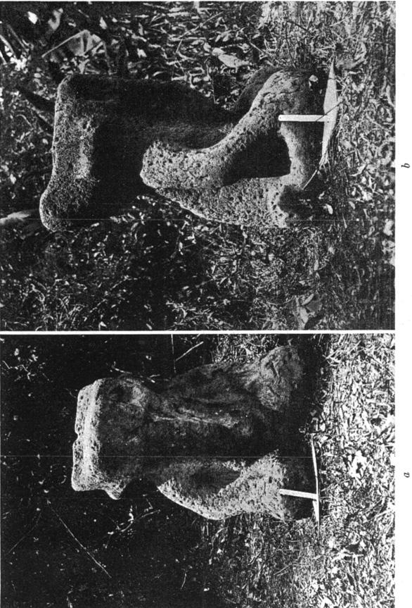
1 PROBOSCIS STATUE FROM THE ISTHMUS OF TEHUANTEPEC By GLADYS AYER NOMLAND N ELEPHANT-LIKE stone statue was discovered in 1930 by Mr. A James P. Fox at Arroyo Sonso, 25 km. southeast of Puerto Mexico and about 15 km. from the Tonola river, which bounds the State of Vera Cruz on the east. When first discovered, the statue was lying in the mud at the bottom of a small arroyo. Later it was extracted and placed on an adjoining alluvial flat or conuco between two streams at the head of Arroyo Sonso, which is a short distance northwest of the locality known as Reyes. There are no indications of the original position or purpose of the image. Pottery sherds are frequent in the alluvial deposits along the near-by streams, but there are no other evidences of aboriginal habitation. The generally flat country immediately surrounding the site is bounded by a series of low sandstone hills where no pottery or stone images were encountered. The statue is made of dark-gray, semi-vesicular basalt. Owing to its texture and mineral constituents, this rock is very hard, so that carving a figure of these proportions from such material would require more effort and skill than in making it from limestone or sandstone, the usual materials of construction in southern Mexico. Deep pitting on the surface of the statue indicates a considerable age. At the time of manufacture it was undoubtedly smooth and clean-cut, but long weathering has pitted the surface and blurred the outlines. At present it is the only stone image known in the immediate vicinity. Other stone statues of human beings, made of basaltic rock evidently derived from the same source, are known at La Venta, about 9 km. east of the Ton016 river in the northwestern part of Tabasco. The La Venta statues are scattered around the foot of La Venta hill, the steep top portion of which has evidently been constructed by aboriginal inhabitants. The nearest locality from which basaltic rock could be obtained is probably the vicinity of the volcano San Martin near the seacoast northwest of the city of Puerto Mexico, and about 60 km. from the Reyes locality. Conveying a block of basalt or a finished statue of comparable weight from such a distance would offer very difficult transportation problems even at the present time. The question of true elephant portrayals in Middle America is of such interest to anthropologists that the writer requested Mr. J. P. Fox, Dr. W. H. Corey, and Dr. J. 0. Nomland to revisit the Arroyo Sonso locality and measure and photograph the image. This was effected in April, 1932, with the following results: 59 1

2 592 AMERICil N ANTHROPOLOGIST [N. s., 34, 1932 The maximum height of the statue is 95 cm. From the base to the top of the shoulder is 60 cm., while the depth from front to back is 60 cm. and the width 72 cm. The head is 35 cm. from neck to top, with a maximum depth of 53 cm. and a width from tips of ears of 50 cm. The fore part of the top of the head is flat, while the back slopes up and terminates in a long projection bisected by a groove 7.5 cm. wide and 5 cm. deep. There are three irregular U-shaped grooves 3 cm. deep on the top surface of the head. The eye-sockets are large, irregular pits varying from 9 to 10 cm. in diameter and 3 cm. deep. From center to center of eye-pits is 24.5 cm. Between the eyes, from the connection of the proboscis to the head, a vertical U-shaped groove 3.5 cm. wide and 16 cm. long extends two-thirds of the distance to the top of the forehead. The rounded proboscis from forehead to belly is 38 cm. long, and slightly larger at the top than at the bottom. At the forehead it is 15 cm., at the chest 14 cm., and at the belly 10 cm. in diameter. The maximum depth is 14.5 cm. The belly is round and pendulous with a possible navel pit. The horizontal ears are bar-shaped, 10 cm. wide, and vary in length, the right being 19 cm. long and the left 18 cm. They are on a level with the eyes and extend 5 cm. from the head. On the lower part of the left arm there is an irregular U-shaped groove 2.3 cm. deep. From elbow to elbow across the front is 68 cm., and from middle to middle of the knees is 50 cm., with a depth of 20 cm. from knee to crotch. The bottom is flat. (Plates 21 and 22.) The possibility of the association of man and elephant in Pleistocene or early Recent times seems to be strengthened by the recent trend of science. In reply to a letter to Professor Chester Stock of the California Institute of Technology regarding such association he wrote under date of June 2, 1932 as follows: If we can definitely establish that man existed in North America in either late Pleistocene or very early Recent time, and if we can determine likewise that he was associated with mammalian forms characteristic of the Ice Age, it seems to me quite possible that such an association would include also representatives of the elephant tribe. However, I would want first also to accumulate more instances of direct association than are available at the present moment before stating that such was actually the case. The probability that the proboscideans survived in later times than has generally been supposed is reenforced by the discovery by Dr. J. 0. Nomland of a late mastodon in Ecuador.' He reports as follows: In the vicinity of the town of Santa Elena, Province of Guayas, several instances of the discovery of elephant and other mammalian remains have been reported. Usually 1 Nomland, J. 0. Unpublished notes.
3

4 Y c) n.a
![NOMLAND] TERUANTEPEC PROBOSCIS STATUE 593 these were found on the surface and without being referable to any definite geological horizon. However, at a location about 28 km.](/docs-images/88/115592741/images/5-0.jpg "northeast of the town of Santa Elena fossil bones of a mastodon have been found whose age seems to be more clearly indicated.")
5 NOMLAND] TERUANTEPEC PROBOSCIS STATUE 593 these were found on the surface and without being referable to any definite geological horizon. However, at a location about 28 km. northeast of the town of Santa Elena fossil bones of a mastodon have been found whose age seems to be more clearly indicated. At that locality there is a spring where even at the present time wild animals come to drink. Evidently the mastodon died after coming to the water hole. The stream bed in which the skeleton occurs has been eroded out of the Pleistocene terraces which are shown very plainly in this part of the country. It is therefore evident that the erosion of the material and deposition of the mastodon bones must have taken place some time after the Pleistocene terrace deposits had been laid down. A still more convincing discovery was made in 1928 by Fr. Spillmann,2 who found a mastodon skeleton at Alangasi, near Quito, Ecuador, which was associated with spear points, fire-places where men evidently cooked the mastodon, and potsherds. Fr. Spillmann states as follows: Die Untersuchung der Tonscherben hatte nun das ganz uberraschende Ergebnis, dass sie einer primitiven Kultur zugezahlt werden mussen, jedoch mit stark majoiden Kultureinflussen. Die Archaologen sind so weit gegangen, dass sie das Alter der Scherben, die mit jenem Mastodonten vergeseflschaftet waren, auf 1600 bis 1800 Jahre geschatzt haben.... Es waren nicht elementare Ereignisse, die diese fossile Fauna vernichtet haben, sondern der Mensch hat bereits einer Kulturstufe angehort, die ihm die Mittel gab, jene Riesenformen zu uberwaltigen. Weiter bedeutet dieser Fund ein wichtiges Element fur die archaologische Forschung Amerikas BELL AVENUE PIEDMONT, CALIFORNIA * Spillmann, Fr. Das sudamerikanischemaslodor, als Zeitgenosse desmenschen majoiden Kulturkreises, Palaeontologische Zeitschrift 11:172,177,1929. a Op. cit., 172: So fand ich z. B. in der Gegend des Beckens,wo das Rektum zu lagen kam, eine grossere Menge von sehr gut erhaltenen Rotballen von ungef&hr 18 cm Durchmesser, kugelrunde Ballen von der Konsistenz des Pferdekotes.
Objectives: Define Relative Age, Absolute Age
 S6E5. Students will investigate the scientific view of how the earth s surface is formed. c. Classify rocks by their process of formation. g. Describe how fossils show evidence of the changing surface
Sediment and sedimentary rocks Sediment
 Sediment and sedimentary rocks Sediment From sediments to sedimentary rocks (transportation, deposition, preservation and lithification) Types of sedimentary rocks (clastic, chemical and organic) Sedimentary
Science and Health EFFECT OF EROSION ON THE CONDITION OF SOIL AND LAND SHAPE
 4 Module 51 Science and Health EFFECT OF EROSION ON THE CONDITION OF SOIL AND LAND SHAPE A DepEd-BEAM Distance Learning Program supported by the Australian Agency for International Development To the Learner
LIBRARY OF. Southern Methodist University DALLAS. TEXAs DINOSAUR TRACKS AT THE FOURTH CROSSING OF THE PALUXY RIVER NEAR GLEN ROSE, TEXAS
 LIBRARY OF Southern Methodist University DALLAS. TEXAs FIELD & LABORATORY Volume V April, 1937 Number 2 DINOSAUR TRACKS AT THE FOURTH CROSSING OF THE PALUXY RIVER NEAR GLEN ROSE, TEXAS Ellis W. Shuler
transform boundary Photograph by Robert E. Wallace, USGS.
 transform boundary The San Andreas Fault is undoubtedly the most famous transform boundary in the world. To the west of the fault is the Pacific plate, which is moving northwest. To the east is the North
Figure 1 The map shows the top view of a meandering stream as it enters a lake. At which points along the stream are erosion and deposition dominant?
 1. In which type of climate does chemical weathering usually occur most rapidly? 1. hot and dry 3. cold and dry 2. hot and wet 4. cold and wet 2. Figure 1 The map shows the top view of a meandering stream
Chapter 10. Chapter Rocks and the Rock Cycle. Rocks. Section 1 Rocks and the Rock Cycle
 Chapter 10 Rocks 1 Chapter 10 Section 1 Rocks and the Rock Cycle 2 10.1 Rocks and the Rock Cycle Magma is the parent material for all rocks. Once the magma cools and hardens, many changes can occur. Geology:
Name. 4. The diagram below shows a soil profile formed in an area of granite bedrock. Four different soil horizons, A, B, C, and D, are shown.
 Name 1. In the cross section of the hill shown below, which rock units are probably most resistant to weathering? 4. The diagram below shows a soil profile formed in an area of granite bedrock. Four different
Rocks: Stony Stalwarts: Adapted from:
 Rocks: Stony Stalwarts: Adapted from: http://science.nationalgeographic.com/science/earth/inside-the-earth/rocks-article/ Rocks are so common that most of us take them for granted cursing when we hit them
2 Igneous Rock. How do igneous rocks form? What factors affect the texture of igneous rock? BEFORE YOU READ. Rocks: Mineral Mixtures
 CHAPTER 2 2 Igneous Rock SECTION Rocks: Mineral Mixtures BEFORE YOU READ After you read this section, you should be able to answer these questions: How do igneous rocks form? What factors affect the texture
Geology Test Review Answers
 Name: Geology Test Review Answers Core: Fill in the blanks: 1. Sediments get compacted and cemented into sedimentary rock. 2. Igneous rocks can be intrusive or extrusive from a volcano. 3. Adding heat
Ch 10 Deposition Practice Questions
 1. Base your answer to the following question on the data table below. Six identical cylinders, A through F, were filled with equal volumes of sorted spherical particles. The data table shows the particle
Lesson 1 Rocks and the Rock Cycle
 Lesson 1 Student Labs and Activities Page Launch Lab 8 Content Vocabulary 9 Lesson Outline 10 MiniLab 12 Content Practice A 13 Content Practice B 14 School to Home 15 Key Concept Builders 16 Enrichment
Starting at Rock Bottom
 Starting at Rock Bottom At rock bottom of the Brushy Creek site s geological column lies the first clue to human habitation: A smelting and heattreating furnace, and mold, carved into Bed Ked: Figure 15
Page 1. Name:
 Name: 1) Which property would best distinguish sediment deposited by a river from sediment deposited by a glacier? thickness of sediment layers age of fossils found in the sediment mineral composition
Landscape evolution. An Anthropic landscape is the landscape modified by humans for their activities and life
 Landforms Landscape evolution A Natural landscape is the original landscape that exists before it is acted upon by human culture. An Anthropic landscape is the landscape modified by humans for their activities
'Published by permission of the director of the U. S. Geological Survey. 330
 SKETCH OF THE GEOLOGY OF THE SALINAS VAL- LEY, CALIFORNIA' IN June and July 19oo, under the direction of Dr. J. C. Branner, Mr. L. D. Mills and the writer undertook to trace out and map the formations
THE MAMMOTH "EARTHQUAKE FAULT" AND RELATED FEATURES IN MON0 COUNTY, CALIFORNIA* By H. BENIOFF and B. GUTENBERG
 THE MAMMOTH "EARTHQUAKE FAULT" AND RELATED FEATURES IN MON0 COUNTY, CALIFORNIA* By H. BENIOFF and B. GUTENBERG IN UNDERTAKING this work it was our intention to investigate the well-known "Earthquake Fault"
LAB 6: TRINIDAD BEACH FIELD TRIP
 OBJECTIVES: LAB 6: TRINIDAD BEACH FIELD TRIP 1) to develop your powers of observation, especially of geological phenomena; 2) to identify the rocks exposed at Trinidad Beach; 3) to reconstruct some of
a) Piedmont: e) Monument: f) Plateau: g) Mesa: h) Butte: i) Playa: j) Perennial Stream:
 Piedmont: e) Monument: f) Plateau: g) Mesa: h) Butte: i) Playa: j) Perennial Stream:") Name: Lab day: Tuesday Wednesday CEEES/SC 10110L-20110L Planet Earth Laboratory Laboratory #11: Arid Environments & Landforms Readings: See handout at http://www.nd.edu/~cneal/physicalgeo/lab-deserts/index.html.
Name: Lab day: Tuesday Wednesday CEEES/SC 10110L-20110L Planet Earth Laboratory Laboratory #11: Arid Environments & Landforms Readings: See handout at http://www.nd.edu/~cneal/physicalgeo/lab-deserts/index.html.
SL GEOLOGY AND MINING. Coal bearing strata in the project area are referable primarily to the Allegheny Group of
 SL-145-1 GEOLOGY AND MINING Coal bearing strata in the project area are referable primarily to the Allegheny Group of Pennsylvania age. These rocks occur as dissected remnants overlying the ridge-forming
Deep Time: How Old Is Old?
 Deep Time: How Old Is Old? Updated by: Rick Oches, Professor of Geology & Environmental Sciences Bentley University Waltham, Massachusetts Based on slides prepared by: Ronald L. Parker, Senior Geologist
Page 1. Name: Period: Date: WS Metamorphic Rocks. The diagram below represents a rock with a distorted layer structure.
 Name: Period: Date: 9317-1 - Page 1 WS Metamorphic Rocks 1) The diagram below represents a rock with a distorted layer structure. 5) Which rock is most likely a nonsedimentary rock? A) a rock showing mud
Name: Period: Date: ID: A. Circle the choice that best completes the statement or answers the question and write the letter on the blank.
 Name: Period: _ Date: _ ID: A Unit 7 Practice Circle the choice that best completes the statement or answers the question and write the letter on the blank. 1. What term describes the movement of rock
TEACHER BACKGROUND KNOWLEDGE. Surface Processes: Weathering and Erosion
 TEACHER BACKGROUND KNOWLEDGE Surface Processes: Weathering and Erosion Core Concepts Precipitation (caused by the water cycle) and wind cause rocks to be broken into smaller pieces in the process called
4. The map below shows a meandering stream. Points A, B, C, and D represent locations along the stream bottom.
 1. Sediment is deposited as a river enters a lake because the A) velocity of the river decreases B) force of gravity decreases C) volume of water increases D) slope of the river increases 2. Which diagram
MOR FOSSILS TEACHERS. Making a Fossil Activity Overview BIG IDEA
 Making a Fossil Activity Overview BIG IDEA OBJECTIVE BACKGROUND Not every organism that died, including dinosaurs, left behind a fossil. Explore fossilization with this activity. Students will follow a
What type of land feature is located at Point A? A Cliff B Delta C Mountain D Valley
 1 What type of land feature is located at Point A? A Cliff B Delta C Mountain D Valley Alfred Wegener s theory of continental drift was 2 not accepted by scientists when the theory was first proposed.
Earth History: Record in the Rocks
 Earth History: Record in the Rocks The geologic history of Earth can be read from rocks if you know what to look for. In this presentation, you will see examples of many types of clues, stored in rocks.
mountain rivers fixed channel boundaries (bedrock banks and bed) high transport capacity low storage input output
 high transport capacity low storage input output") mountain rivers fixed channel boundaries (bedrock banks and bed) high transport capacity low storage input output strong interaction between streams & hillslopes Sediment Budgets for Mountain Rivers Little
mountain rivers fixed channel boundaries (bedrock banks and bed) high transport capacity low storage input output strong interaction between streams & hillslopes Sediment Budgets for Mountain Rivers Little
All About Rocks. What Exactly Are Rocks? 298 words. Born from Magma: Igneous Rock 223 words. Layer After Layer: Sedimentary Rock 192 words
 ARTICLE-A-DAY All About Rocks 6 Articles Check articles you have read: What Exactly Are Rocks? 298 words Born from Magma: Igneous Rock 223 words Layer After Layer: Sedimentary Rock 192 words Changing Form:
Hafeet mountain. Rocks
 Hafeet mountain Rocks There are several steps that lead to form the rocks Weathering Erosion Deposition Heat and pressure Weathering Ice (expand inside the rock fractures) Plants (grows through fractures
Pratice Surface Processes Test
 1. The cross section below shows the movement of wind-driven sand particles that strike a partly exposed basalt cobble located at the surface of a windy desert. Which cross section best represents the
THE OHIO JOURNAL OF SCIENCE
 THE OHIO JOURNAL OF SCIENCE VOL. LIII MARCH, 1953 No. 2 SUBSURFACE STUDY OF GLACIAL DEPOSITS AT CLEVELAND, OHIO C. T. BAGLEY Sverdrup & Parcel, Inc., Consulting Engineers, St. Lotus, Mo. The soil 1 strata
GIFFORD PINCHOT STATE PARK DIABASE (MOLTEN LIQUID ROCK)
") PENNSYLVANIA TRAIL OF GEOLOGY PARK GUIDE 10 GIFFORD PINCHOT STATE PARK DIABASE (MOLTEN LIQUID ROCK) Gifford Pinchot State Park contains examples of the three major rock classes: igneous, metamorphic, and
PENNSYLVANIA TRAIL OF GEOLOGY PARK GUIDE 10 GIFFORD PINCHOT STATE PARK DIABASE (MOLTEN LIQUID ROCK) Gifford Pinchot State Park contains examples of the three major rock classes: igneous, metamorphic, and
Cretaceous, Dakota Formation, Terra Cotta Member South Side of I-70, Salina County, Kansas
 Cretaceous, Dakota Formation, Terra Cotta Member South Side of I-70, Salina County, Kansas Written By: Steven D.J. Baumann G-102010-1A Outcrop looking southeast Photo taken by: Steven Baumann on 10-20-2010
Appendix I-1: Archaeological Records Search
 Appendix I-1: Archaeological Records Search South Central Coastal Information Center California State University, Fullerton Department of Anthropology MH-426 800 North State College Boulevard Fullerton,
Chapter 8 Earth Systems and Resources
 Chapter 8 Earth Systems and Resources Earth s resources were determined when the planet formed. The Earth s Crust Layers Core: innermost zone of the planet, largely nickel and iron. Mantle: above the core,
Starting at Rock Bottom: A Peculiar Central Texas PreClovis Culture
 Starting at Rock Bottom: A Peculiar Central Texas PreClovis Culture Background Brushy Creek grades, overall, west-northwest (WNW) to east-southeast (ESE) through the easternmost portions of the central
KRIS wsbssm. IBHiiilll
 KRIS wsbssm IBHiiilll Digitized by the Internet Archive in 2012 with funding from University of Illinois Urbana-Champaign http://archive.org/details/engineeringaspec34ekbl STATE OF ILLINOIS HENRY HORNER,
SCI-5 KES 5.7 Geology Post-test Exam not valid for Paper Pencil Test Sessions
 SCI-5 KES 5.7 Geology Post-test Exam not valid for Paper Pencil Test Sessions [Exam ID:1D5NLH 1 Earth's crust is made of plates that move slowly. This movement changes the appearance of the Earth's crust
Lecture Outline Wednesday - Friday February 14-16, 2018
 Lecture Outline Wednesday - Friday February 14-16, 2018 Quiz 2 scheduled for Friday Feb 23 (Interlude B, Chapters 6,7) Questions? Chapter 6 Pages of the Past: Sedimentary Rocks Key Points for today Be
Earth s Dynamic Surface
 Earth s Dynamic Surface Key Concepts What is the difference between physical and chemical weathering? How do water, ice, and wind change Earth s surface? Changing Earth s Surface What do you think? Read
The Niagara Escarpment extends from western New York, through the GTA all the way up to Manitoulin Island and into Michigan and Wisconsin.
 is southern Ontario s most prominent topographic feature, extending more than 500 kilometres from western New York, through Niagara Falls and the western part of the Greater Toronto Area (GTA), and north
Mammoth Cave National Park, Kentucky
 Mammoth Cave National Park, Kentucky Objectives of Today s Lecture Refresher on Sedimentary Depositional Systems and Rock Classifications Transgressive and Regressive Marine Environments Carbonate Depositional
Benchmark 3 Science Study Guide S6E5 A-Crust, Mantle, Core 1. What happens to the temperature as you travel to the center of the Earth?
 Benchmark 3 Science Study Guide S6E5 A-Crust, Mantle, Core 1. What happens to the temperature as you travel to the center of the Earth? IT GETS HOTTER. 2. What happens to the density as you travel to the
Sedimentary Rocks. Origin, Properties and Identification. Physical Geology GEOL 101 Lab Ray Rector - Instructor
 Sedimentary Rocks Origin, Properties and Identification Physical Geology GEOL 101 Lab Ray Rector - Instructor Sedimentary Rock Origin and Identification Lab Pre-Lab Internet Link Resources 1) http://www.rockhounds.com/rockshop/rockkey/index.html
As compaction and cementation of these sediments eventually occur, which area will become siltstone? A) A B) B C) C D) D
 A B) B C) C D) D") 1. A student obtains a cup of quartz sand from a beach. A saltwater solution is poured into the sand and allowed to evaporate. The mineral residue from the saltwater solution cements the sand grains together,
1. A student obtains a cup of quartz sand from a beach. A saltwater solution is poured into the sand and allowed to evaporate. The mineral residue from the saltwater solution cements the sand grains together,
Black Point & Bihler Point
 Black Point & Bihler Point Conglomerate Photo: looking north toward end of Black Point (south of post 1) All of the rocks in this photo are conglomerate. Both Black Point and Bihler Point are formed from
Structural Geology Lab. The Objectives are to gain experience
 Geology 2 Structural Geology Lab The Objectives are to gain experience 1. Drawing cross sections from information given on geologic maps. 2. Recognizing folds and naming their parts on stereoscopic air
Rock Cycle. Presented by Kesler Science
 Presented by Kesler Science Essential Questions: What processes are involved in the formation and classification of metamorphic, sedimentary, and igneous rocks? Sediments A model that describes the formation,
Landscape. Review Note Cards
 Landscape Review Note Cards Last Ice Age Pleistocene Epoch that occurred about 22,000 Years ago Glacier A large, long lasting mass of ice which forms on land and moves downhill because of gravity. Continental
Unit 2: Geology of Tsikw aye (Mesa Prieta)
") Unit 2 page 9 Name: Date: GEOLOGIC HISTORY OF MESA PRIETA: Student Information Sheet: Activity 2 Looking at Mesa Prieta today, with its tumbled black basalt boulders, prickly pear cacti and an occasional
Unit 2 page 9 Name: Date: GEOLOGIC HISTORY OF MESA PRIETA: Student Information Sheet: Activity 2 Looking at Mesa Prieta today, with its tumbled black basalt boulders, prickly pear cacti and an occasional
Earth s Changing Surface
 Earth s Changing Surface Fourth grade scientists are introduced to the scope of geologic time and learn about forces that change our Earth s surface. During their study, students use scientific modeling
Unit 7.2 W.E.D. & Topography Test
 Name: Score: Unit 7.2 W.E.D. & Topography Test 1. 2. 3. 4. 5. 6. 7. 8. 9. 10. 11. 12. 13. 14. 15. 16. 17. 18. 19. 20. 21. 22. 23. 24. 25. 1. The formation of mountains is due mainly to while the destruction
Chapter 6 Pages of Earth s Past: Sedimentary Rocks
 Chapter 6 Pages of Earth s Past: Sedimentary Rocks Introduction! Drilling into the bottom of the North Sea, we encounter: " Soft mud and loose sand, silt, pebbles, and shells. Then: " Similar materials
1. The topographic map below shows a depression contour line on Earth's surface.
 1. The topographic map below shows a depression contour line on Earth's surface. Points A, B, C, and D represent surface locations. Contour line elevations are in feet. Which profile best shows the topography
Sedimentary Rocks. Origin, Properties and Identification. Geology Laboratory GEOL 101 Lab Ray Rector - Instructor
 Sedimentary Rocks Origin, Properties and Identification Geology Laboratory GEOL 101 Lab Ray Rector - Instructor Sedimentary Rock Origin and Identification Lab Pre-Lab Internet Link Resources 1) http://www.rockhounds.com/rockshop/rockkey/index.html
What are the different ways rocks can be weathered?
 Romano - 223 What are the different ways rocks can be weathered? Weathering - the breakdown of rocks and minerals at the Earth s surface 1. 2. PHYSICAL WEATHERING Rock is broken into smaller pieces with
THE STRUCTURE AND THICKNESS OF THE CLINTON AND BEREA FORMATIONS IN THE VICINITY OF WOOSTER, OHIO
 THE STRUCTURE AND THICKNESS OF THE CLINTON AND BEREA FORMATIONS IN THE VICINITY OF WOOSTER, OHIO KARL VER STEEG College of Wooster INTRODUCTION AND ACKNOWLEDGMENTS The data used in the construction of
Sedimentary Rocks, our most Valuable Rocks. Or, what you will probably find when you are outdoors exploring.
 Sedimentary Rocks, our most Valuable Rocks Or, what you will probably find when you are outdoors exploring. Sedimentary rocks give us evidence to earth s earlier history. We look at processes happening
Coso Red Hill and Coso Playa field trip, Prof. Alessandro Grippo, Ph.D.
 HISTORICAL GEOLOGY fall 2016 Professor: Dr. Alessandro Grippo, Ph.D. FIELD TRIP REPORT: Friday, October 21, 2016: Coso Red Hill & Playa, Coso Junction CA YOUR NAME part 1: COSO RED HILL (you can sample
!!!!! STOP!!!!! What is environmental geology? Earth as a closed system implies nearly everything is cycled, recycled
 What is environmental geology?!!!!! STOP!!!!! Geology Study of rocks and minerals that comprise earth s surface and interior and the natural processes that shape the earth s surface and interior over all
!!!!! STOP!!!!! What is environmental geology?
 !!!!! STOP!!!!! What is environmental geology? Geology Study of rocks and minerals that comprise earth s surface and interior and the natural processes that shape the earth s surface and interior over
Earth History Exam. The remains of an early dinosaur could be found at reference point A. A B. B C. C D. D. page 1
 Name: Date: 1. Base your answer(s) to the following question(s) on the Earth Science Reference Tables and your knowledge of Earth science. The accompanying cross section shows undisturbed sedimentary bedrock.
Which particle of quartz shows evidence of being transported the farthest distance by the stream? A) B) C) D)
 B) C) D)") 1. Base your answer to the following question on the block diagram below, which represents the landscape features associated with a meandering stream. WX is the location of a cross section. Location A
1. Base your answer to the following question on the block diagram below, which represents the landscape features associated with a meandering stream. WX is the location of a cross section. Location A
Continental Landscapes
 Continental Landscapes Landscape influenced by tectonics, climate & differential weathering Most landforms developed within the last 2 million years System moves toward an equilibrium Continental Landscapes
Module 10: Resources and Virginia Geology Topic 4 Content: Virginia Geology Notes
 Virginia is composed of a very diverse landscape that extends from the beaches and barrier islands all of the way to the highly elevated Appalachian Plateau. Geologists have discovered ancient shallow
The Nature of Sedimentary Rocks
 The Nature of Sedimentary Rocks Sedimentary rocks are composed of: Fragments of other rocks Chemical precipitates Organic matter or biochemically produced materials The Nature of Sedimentary Rocks Sedimentary
WEATHERING, EROSION & DEPOSITION STUDY GUIDE
 WEATHERING, EROSION & DEPOSITION STUDY GUIDE Weathering: The difference between mechanical & chemical weathering is: Sort terms as being mechanical/physical or chemical weathering: acid rain, root splitting
Name HW - Landscapes
 Name HW - Landscapes 1. New York s Tug Hill landscape region is classified as a plateau because this region has a A) high elevation with distorted bedrock B) high elevation with nearly horizontal layers
Geology Photograph Album
 Geology Photograph Album Josh Gibson Geology 100 July 2, 2007 Ridges of Resistant Rock Gravel Beds Feature: Differential Weathering Location: Otay Mesa, CA N 32 34.528 W 116 59.921 Date: June 19, 2007
2 Igneous Rock. How do igneous rocks form? What factors affect the texture of igneous rock? BEFORE YOU READ. Rocks: Mineral Mixtures
 CHAPTER 4 2 Igneous Rock SECTION Rocks: Mineral Mixtures BEFORE YOU READ After you read this section, you should be able to answer these questions: How do igneous rocks form? What factors affect the texture
Maine Geologic Facts and Localities October, Lobster Lake, Maine. Text by Robert G. Marvinney. Maine Geological Survey
 Maine Geologic Facts and Localities October, 1998 Lobster Lake, Maine 45 o 51 7.91 N, 69 o 30 53.88 W Text by Robert G. Marvinney, Department of Agriculture, Conservation & Forestry 1 Map by Introduction
Clastic Sedimentary Rocks
 Clastic Sedimentary Rocks Alessandro Grippo, Ph.D. Alternating sandstones and mudstones in Miocene turbidites Camaggiore di Firenzuola, Firenze, Italy Alessandro Grippo review Mechanical weathering creates
Gravel Transport Can Determine Late Flood Tectonics
 Chapter 23 Gravel Transport Can Determine Late Flood Tectonics The locations of all the quartzite gravel in the northwest states and adjacent Canada provide more information about the Flood than just reinforcing
The boulder was most likely moved to this location by A) glacial ice B) prevailing wind C) streamfiow D) volcanic action
 glacial ice B) prevailing wind C) streamfiow D) volcanic action") 1. Which rock material was most likely transported to its present location by a glacier? A) rounded sand grains found in a river delta B) rounded grains found in a sand dune C) residual soil found on a
1. Which rock material was most likely transported to its present location by a glacier? A) rounded sand grains found in a river delta B) rounded grains found in a sand dune C) residual soil found on a
Watch the next few slides. When the slides stop transitioning get with an elbow partner to discuss the events that caused the formation of the
 Watch the next few slides. When the slides stop transitioning get with an elbow partner to discuss the events that caused the formation of the beautiful features. Be as specific as possible. Discuss
Landscape Development
 CHAPTER 22 Landscape Development Chapter Summary Landscapes are described in terms of their topography: elevation, the altitude of the surface of the Earth above sea level; relief, the difference between
Soil. Soil in Our Environment
 Soil Soil in Our Environment What is soil? Or is it Dirt? Gold s father is dirt, yet it regards itself as noble. Yiddish Proverb Is it alive? Is it fragile? Formations of Soils How much time does it take
Directed Reading. Section: Rocks and the Rock Cycle. made of a. inorganic matter. b. solid organic matter. c. liquid organic matter. d. chemicals.
 Skills Worksheet Directed Reading Section: Rocks and the Rock Cycle 1. The solid part of Earth is made up of material called a. glacial ice. b. lava. c. rock. d. wood. 2. Rock can be a collection of one
Name: Which rock layers appear to be most resistant to weathering? A) A, C, and E B) B and D
 A, C, and E B) B and D") Name: 1) The formation of soil is primarily the result of A) stream deposition and runoff B) precipitation and wind erosion C) stream erosion and mass movement D) weathering and biological activity 2)
Name: 1) The formation of soil is primarily the result of A) stream deposition and runoff B) precipitation and wind erosion C) stream erosion and mass movement D) weathering and biological activity 2)
Writing Earth s History
 Earths History Writing Earth s History How is Earths History like writing in your Journal? Everyday, something happens and, with a pen, it is written down in the pages of your journal. As you continue,
Practice Questions for Lecture 5 Geology 1200
 Practice Questions for Lecture 5 Geology 1200 Use these questions to test your knowledge of Lecture5. The exams will be similar in format, except that they will deal with more than one chapter, and will
abrasion the rubbing, grinding, and bumping of rocks that cause physical weathering (SRB, IG)
") FOSS Soils, Rocks, and Landforms Module Glossary NGSS Edition 2019 abrasion the rubbing, grinding, and bumping of rocks that cause physical weathering (SRB, IG) acid a substance that geologists use to
FOSS Soils, Rocks, and Landforms Module Glossary NGSS Edition 2019 abrasion the rubbing, grinding, and bumping of rocks that cause physical weathering (SRB, IG) acid a substance that geologists use to
Structural Geology Lab. The Objectives are to gain experience
 Geology 2 Structural Geology Lab The Objectives are to gain experience 1. Drawing cross sections from information given on geologic maps. 2. Recognizing folds and naming their parts on stereoscopic air
4.1 Act 2 Rock Cycle: Interactive Website Worksheet
 Name Date Core 4.1 Act 2 Rock Cycle: Interactive Website Worksheet Directions: Go to the website Interactives Rock Cycle. http://www.learner.org/interactives/rockcycle/index.html Follow the directions
Sedimentary Rocks. Origin, Properties and Identification. Physical Geology GEOL 100. Ray Rector - Instructor
 Sedimentary Rocks Origin, Properties and Identification Physical Geology GEOL 100 Ray Rector - Instructor Sedimentary Rock Origin and Identification Lab Pre-Lab Internet Link Resources 1) http://www.rockhounds.com/rockshop/rockkey/index.html
STAAR Science Tutorial 40 TEK 8.9C: Topographic Maps & Erosional Landforms
 Name: Teacher: Pd. Date: STAAR Science Tutorial 40 TEK 8.9C: Topographic Maps & Erosional Landforms TEK 8.9C: Interpret topographic maps and satellite views to identify land and erosional features and
Sediment and Sedimentary rock
 Sediment and Sedimentary rock Sediment: An accumulation of loose mineral grains, such as boulders, pebbles, sand, silt or mud, which are not cemented together. Mechanical and chemical weathering produces
Erosion Surface Water. moving, transporting, and depositing sediment.
 + Erosion Surface Water moving, transporting, and depositing sediment. + Surface Water 2 Water from rainfall can hit Earth s surface and do a number of things: Slowly soak into the ground: Infiltration
Description DESCRIPTION
 DESCRIPTION The location of the Upper James Watershed is located in northeastern South Dakota as well as southeastern North Dakota. It includes the following counties located in North Dakota Barnes, Dickey,
Chapter 1 Section 2. Land, Water, and Climate
 Chapter 1 Section 2 Land, Water, and Climate Vocabulary 1. Landforms- natural features of the Earth s land surface 2. Elevation- height above sea level 3. Relief- changes in height 4. Core- most inner
Introducti on. Land Survey. Geomagnetic Survey. Geomagnetic Results and Interpretati ons - Conclusions and Recommendations C
 m M 42A86SW8281 63.42 PRICE 010 C O H T E H l 42A86SW828I 63.42 PRICE 010C Introducti on Land Survey Geomagnetic Survey Geomagnetic Results and Interpretati ons - Conclusions and Recommendations - - -
Report to Schools June 2003
 Geology 12 Provincial Examination Report to Schools June 2003 Ministry of Education Assessment Department % of Students SCHOOL MARK 50 40 29 30 17 14 16 16 20 8 10 0 A B C+ C C- F Letter Grade EXAM MARK
ROCKS Made of Minerals
 ROCKS Made of Minerals There are many types of minerals and most of them are used by organic creatures or by industry in some way or another. Some minerals are rare and very costly. Rock cycle This should
Full file at
 Chapter 2 PLATE TECTONICS AND PHYSICAL HAZARDS MULTIPLE-CHOICE QUESTIONS 1. What direction is the Pacific Plate currently moving, based on the chain of Hawaiian Islands with only the easternmost island
1. Erosion by Running Water Most powerful cause of erosion
 I. Destructive Forces Notes: Destructive force: a process in which land is destroyed or changed such as weathering and erosion. All landforms are a result of a combination of constructive and destructive
What is weathering and how does it change Earth s surface? Answer the question using
 7 th Grade Lesson What is weathering and how does it change Earth s surface? Answer the question using the sentence frame. You have 4 minutes. Weathering is. This changes the Earth s surface because. 1
N. J. Macala. C ONTENT S. LIST OF PLATES.
 REPORT ON WATER SUikLY AT MANBULLOO STATION, NORTHERN TERRITORY. by N. J. Macala. Records 1957/62. C ONTENT S. Page. Introduction. 1. General Geology, 1. Hydrology. 1. New Bore Sites Selected. 2. Reference.