Optical and Acoustic Televiewer Borehole Logging Improved Oriented Core Logging Techniques
|
|
|
- Adelia Whitehead
- 5 years ago
- Views:
Transcription


1 Optical and Acoustic Televiewer Borehole Logging Improved Oriented Core Logging Techniques Tom Eliassen, VTrans; Dorothy Richter, Hager-Richter Geoscience; Heather Crow, Peter Ingraham & Trevor Carter, Golder Associates


2 MYTHBUSTERS
3 THE PROBLEM: Highly fractured zones and soil filled joints four episodes of folding and faulting Folded rock fabric within cut


4 THE PROBLEM: Maintaining core orientation difficult in highly fractured rock soil seams up to 4 to 6 thick, significant core loss Local drillers not accustomed to double-or triple-tube coring methods 15-foot rockfall boulder in Route 9 ditch


5 LIMITED BEDROCK EXPOSURES:
6 PROJECT APPROACH: Collect joint and discontinuity data with a coordinated field mapping and coring program Geophysical borehole logging using optical or acoustic methods Measurement and assessment of joint planes and laboratory testing of core samples.
7 OPTICAL AND ACOUSTIC LOGGING: Early logging developed in the 1960 s in the oil patch recent advances in data processing and field equipment have yielded highly mobile and practical applications. Good core drilling and sampling is still g p g vital for verification, lab samples and to assess joint planes

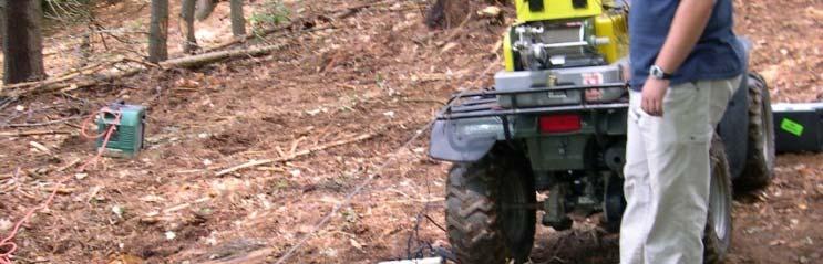
8 BOREHOLE TELEVIEWERS: Can replace Oriented Coring with an oriented image of the borehole wall Enhance geotechnical data with high-resolution in situ images Can be a cost effective investigation technique


9 Small, Portable The Logging System Laptop controlled data collection - QC on site Operates independently of the drill rig


10 Televiewers: Optical and Acoustic Optical: High-resolution digital image of borehole wall Acoustic: Sonar image of g borehole wall


11 TELEVIEWER INTERPRETATION Plane Slice Through a Clid Cylinder Produces Sinusoid in the Unwrapped Televiewer Image N E S W N


12 Optical Images in Fault Zones: Collecting Data in Poor Rock 230 m m Bro ken Core 18.0 m Mis ssing Core 231 m 19.0 m m Granite Shale


13 INTEGRATION WITH GEOTECHNICAL DATA
14 Geotechnical Data and Televiewer Images: One Log Sheet


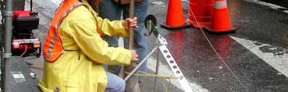
15 Route 9 Improvements, Vermont: All Terrain Vehicle w/ Gen-Set & Tools Winch, Data Processor and Laptop p Caliper Tool Optical Televiewer Tool Acoustic Televiewer Tool


16 Route 9 Improvements, Vermont:
17 Route 9 Improvements, Vermont:


18 I-93 Improvements, New Hampshire:


19 I-93 Improvements, New Hampshire:


20 I-93 Improvements, New Hampshire
21 Route 9 Improvements, Vermont: Optical Televiewer Log
22 Route 9 Improvements, Vermont: Acoustic Televiewer Log


23 Televiewer Logging in New York City: Getting there is half the battle.


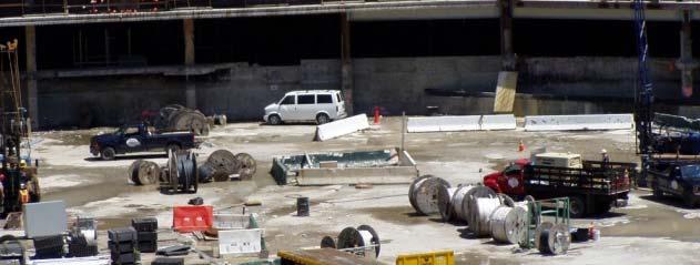

24 Freedom Tower, World Trade Center Site:
25 Televiewer Logging New York City: NYC Televiewer Log


26 Diavik Diamond Mine


27 Diavik Diamond Mine Geotechnical drilling for pit slope stability investigation Televiewers introduced oriented coring phased out
28 Diavik Diamond Mine Advantages: Structural data where it s most needed Zone of Broken Core Core Photograph Televiewer interprets data reliably in fracture zone


29 Diavik Diamond Mine Primary Benefits: Costs reduced fewer staff, fewer hours on site, faster, more accurate core logging Improved results greater confidence in structural orientations, in situ images, comprehensive log sheets


30 Tuen Mun Road - Hong Kong Acoustic and impression packer core orientation foam coring Six major sheet joints in micro fractured granite 9000 vehicles/hr Six Lanes


31 WellCad Televiewer Tools: Virtual cores can be developed from televiewer images and viewed from all angles Virtual Acoustic Core - NYC Virtual Optical Core - VT
32 Example Virtual Core plots from OPTICAL Televiewer Fractures with Alterationti Calcite Veins in Fault Zone Soft Clay Interval Within a Fault Zone Calcite Veins in Fault Zone Valuable for: Design Assessment Data Interpretation Contractor bidding
33 Televiewer Project Considerations: OPTICAL TELEVIEWER Borehole diameter 3 12 inches Clean borehole clear fluid or air filled Logging has produced excellent results in diamond drill and good results in air rotary boreholes ACCOUSTIC TELEVIEWER borehole diameter 3 12 inches Fluid need not be clear but must be present in borehole Logging has produced excellent results in diamond drill and good - fair results in air rotary boreholes
34 Borehole Televiewers: What can be gained? Accurate structural orientations of features in vertical and inclined boreholes Image of rock conditions in situ leading to improved geotechnical information Significant cost savings when compared to traditional oriented core methods
35 Challenges Ahead Merge the Geotechnical and Televiewer Information; and Automate Stereronet Production and Joint Set Data Synthesis.
36 The best part about trees in Vermont. Questions?
HOW. HOW vehicle mounted units portable units also available. HOW, WHEN & WHY to Geophysically Log in S.I.?
 HOW, WHEN & WHY to Geophysically Log in S.I.? by Kim Beesley HOW HOW vehicle mounted units portable units also available Access to borehole Depth of borehole sump / rat -hole? 1 HOW? - subject to borehole
BOREHOLE GEOPHYSICAL LOGGING RAGGED MOUNTAIN PROJECT CHARLOTTESVILLE, VIRGINIA
 BOREHOLE GEOPHYSICAL LOGGING RAGGED MOUNTAIN PROJECT CHARLOTTESVILLE, VIRGINIA Prepared for: Black & Veatch Corporation 18310 Montgomery Village Avenue, Suite 500 Gaithersburg, Maryland 20879 Prepared
Geotechnical data from optical and acoustic televiewer surveys
 Geotechnical data from optical and acoustic televiewer surveys by Farrin De Fredrick MAusIMM, Senior Geotechnical Engineer; Ta Nguyen AIG, Geotechnical Engineer; Clive Seymour MAusIMM, Principal; and Gary
Geologging Imagery, Applications and Geological Interpretation. Shea Altadonna 1, Jim Fulton 2, E.I.T.
 Geologging Imagery, Applications and Geological Interpretation Shea Altadonna 1, Jim Fulton 2, E.I.T. 1 Geologist, Advanced Construction Techniques Inc. 1000 N. West St. Ste 1200, Wilmington, DE 19801;
Site investigation in rock
 Site investigation in rock masses Geotechnical Core Drilling & Logging Core Orientation Borehole Surveying Logging g Core Borehole Log Face Mapping Scanline Data Analysis Influence of Joints Orientation
Instructional Objectives
 GE 6477 DISCONTINUOUS ROCK 8. Fracture Detection Dr. Norbert H. Maerz Missouri University of Science and Technology (573) 341-6714 norbert@mst.edu Instructional Objectives 1. List the advantages and disadvantages
SCOPE OF INVESTIGATION Simple visual examination of soil at the surface or from shallow test pits. Detailed study of soil and groundwater to a
 Lecture-5 Soil Exploration Dr. Attaullah Shah 1 Today s Lecture Purpose of Soil Exploration Different methods 1. Test trenches and Pits 2. Auger and Wash Boring 3. Rotary Drilling 4. Geophysical Methods
10. GEOTECHNICAL EXPLORATION PROGRAM
 Geotechnical site investigations should be conducted in multiple phases to obtain data for use during the planning and design of the tunnel system. Geotechnical investigations typically are performed in
BOREHOLE GEOPHYSICAL LOGGING SERVICES SUN/CROSS RIVER - PROJECT # 97016A DEVITO S SERVICE STATION 880 ROUTE 35 CROSS RIVER, NEW YORK
 BOREHOLE GEOPHYSICAL LOGGING SERVICES SUN/CROSS RIVER - PROJECT # 97016A DEVITO S SERVICE STATION 880 ROUTE 35 CROSS RIVER, NEW YORK Prepared for: Matrix Environmental Technologies, Inc. 16 Walker Way
Boreholes. Implementation. Boring. Boreholes may be excavated by one of these methods: 1. Auger Boring 2. Wash Boring 3.
 Implementation Boreholes 1. Auger Boring 2. Wash Boring 3. Rotary Drilling Boring Boreholes may be excavated by one of these methods: 4. Percussion Drilling The right choice of method depends on: Ground
Title: Author: Background: Maximise core recovery: Identify and resolve orientation and data transfer issues at rig:
 Title: HOW TO MAXIMISE THE QUALITY AND VALUE OF STRUCTURAL DATA FOR YOUR PROJECT - A PRACTICAL GUIDE TO COMMON PROBLEMS WITH FIELD DATA TRANSFER WHEN ORIENTATING CORE. Author: Gavin McLeod Background:
How to Interpret Mining Company Drill Reports & Announcements
 How to Interpret Mining Company Drill Reports & Announcements A Simple Guide amscot Stockbroking Pty Ltd A division of State One Stockbroking Ltd (AFSL 247 100) Disclaimer: All information in this document
Standard Test Method for Determination of the In-Situ Stress in Rock Using the Hydraulic Fracturing Method 1
 Designation: D 4645 04 Standard Test Method for Determination of the In-Situ Stress in Rock Using the Hydraulic Fracturing Method 1 This standard is issued under the fixed designation D 4645; the number
APPENDIX B SUBSURFACE EXPLORATIONS
 APPENDIX B SUBSURFACE EXPLORATIONS 51-1-10079-028 APPENDIX B SUBSURFACE EXPLORATIONS TABLE OF CONTENTS Page B.1. B.2. B.3. B.4. B.5. B.6. B.7. GENERAL...B-1 HEALTH AND SAFETY PLAN...B-1 DRILLING PROCEDURES...B-1
SI Planning & Laboratory Testing for Hill-Site Development
 SI Planning & Laboratory Testing for Hill-Site Development 21 April 2009 IEM Penang Ir. Tan Yean Chin G&P Geotechnics Sdn Bhd Cameron Highlands, 1961 Genting Highland Tower 1993 Bukit Antarabangsa, 1999
Geotechnical & Mining Engineering Services
 Geotechnical & Mining Engineering Services Southwest Research Institute San Antonio, Texas A s an independent, nonprofit research and development organization, Southwest Research Institute (SwRI ) uses
Geophysical Site Surveys
 Geophysical Site Surveys Simon Oakley Geoscience Team Leader Fugro Survey Limited 16/04/2014 Contents Menu Introduction Section 1 - Geophysical Site Surveys - Seabed Bathymetry - Shallow Geology - Seabed
Chapter 12 Subsurface Exploration
 Page 12 1 Chapter 12 Subsurface Exploration 1. The process of identifying the layers of deposits that underlie a proposed structure and their physical characteristics is generally referred to as (a) subsurface
Gotechnical Investigations and Sampling
 Gotechnical Investigations and Sampling Amit Prashant Indian Institute of Technology Gandhinagar Short Course on Geotechnical Investigations for Structural Engineering 12 14 October, 2017 1 Purpose of
Measurement of effective stress shear strength of rock
 Measurement of effective stress shear strength of rock R. A. Failmezger, P.E., F. ASCE In-Situ Soil Testing, L.C., Lancaster, Virginia USA D. J. White, Ph. D., P.E. Iowa State University, Ames, Iowa USA
Rotary Drilling Rotary Drilling Bits
 GE 343 SUBSURFACE EXPLORATION CH 8 Rock Drilling, Testing, and Sampling Text Ch. 7. Dr. Norbert H. Maerz Missouri University of Science and Technology (573) 341-6714 norbert@mst.edu Instructional Objectives
Underground Risk Management Course Marina Del Rey, California November, Geotechnical Data Reports. Greg Raines, PE
 Underground Risk Management Course Marina Del Rey, California November, 2018 Geotechnical Data Reports Greg Raines, PE Gregory.Raines@Stantec.com Introduction What is a Geotechnical Data Report? The GDR
Huaman A., Cabrera J. and Samaniego A. SRK Consulting (Peru) Introduction ABSTRACT
 Introduction ABSTRACT") Managing and validating limited borehole geotechnical information for rock mass characterization purposes experience in Peruvian practice for open pit mine projects Huaman A., Cabrera J. and Samaniego
Managing and validating limited borehole geotechnical information for rock mass characterization purposes experience in Peruvian practice for open pit mine projects Huaman A., Cabrera J. and Samaniego
Module 1 : Site Exploration and Geotechnical Investigation
 Objectives In this section you will learn the following Displacement borings Wash boring Auger boring Rotary drilling Percussion drilling Continuous sampling Boring methods of exploration The boring methods
Instructional Objectives
 GE 343 SUBSURFACE EXPLORATION CH 8 Rock Drilling, Testing, and Sampling Text Ch. 7. Dr. Norbert H. Maerz Missouri University of Science and Technology (573) 341-6714 norbert@mst.edu Instructional Objectives
Role of the Geotechnical Consultant in Design Build Projects a General Contractors Geotechnical Engineer s Perspective
 Role of the Geotechnical Consultant in Design Build Projects a General Contractors Geotechnical Engineer s Perspective Steven R. Saye Kiewit Engineering Group, Inc. Design Build Geotechnical Goal All parties
SASKATCHEWAN STRATIGRAPHY GLACIAL EXAMPLE BOULDERS IN GLACIAL DEPOSITS
 SASKATCHEWAN STRATIGRAPHY GLACIAL EXAMPLE BOULDERS IN GLACIAL DEPOSITS 51 SASKATCHEWAN STRATIGRAPHY GLACIAL SURFICIAL STRATIFIED DEPOSITS 52 SASKATCHEWAN STRATIGRAPHY GLACIAL EXAMPLE OF SEDIMENT DEPOSITION
Drilling Induced Fracture (DIF) Characterization and Stress Pattern Analysis of the Southern McMurdo Sound (SMS) Core, Vitoria Land Basin, Antarctica
 Characterization and Stress Pattern Analysis of the Southern McMurdo Sound (SMS) Core, Vitoria Land Basin, Antarctica") Drilling Induced Fracture (DIF) Characterization and Stress Pattern Analysis of the Southern McMurdo Sound (SMS) Core, Vitoria Land Basin, Antarctica ABSTRACT Ezer Patlan Academic Affiliation, Fall 2008:
Drilling Induced Fracture (DIF) Characterization and Stress Pattern Analysis of the Southern McMurdo Sound (SMS) Core, Vitoria Land Basin, Antarctica ABSTRACT Ezer Patlan Academic Affiliation, Fall 2008:
2 OVERVIEW OF SHALLOW BOREHOLE INVESTIGATIONS
 2 OVERVIEW OF SHALLOW BOREHOLE INVESTIGATIONS Preparation for MSB-2 started in April 2002. Drilling and planned field work in both MSB-2 and 4 were carried out at the same time. After completion of the
The process of determining the layers of natural soil deposits that will underlie a proposed structure and their physical properties is generally
 The process of determining the layers of natural soil deposits that will underlie a proposed structure and their physical properties is generally referred to as sub surface investigation 2 1 For proper
Case Study: University of Connecticut (UConn) Landfill
 Landfill") Case Study: University of Connecticut (UConn) Landfill Problem Statement:» Locate disposal trenches» Identify geologic features and distinguish them from leachate and locate preferential pathways in fractured
Case Study: University of Connecticut (UConn) Landfill Problem Statement:» Locate disposal trenches» Identify geologic features and distinguish them from leachate and locate preferential pathways in fractured
Coating Requirements for Pipelines Installed by Horizontal Directional Drilling John D. Hair, P.E.*
 Coating Requirements for Pipelines Installed by Horizontal Directional Drilling John D. Hair, P.E.* *President, J. D. Hair & Associates, Inc., 2121 South Columbia Avenue, Suite 101, Tulsa, OK 74114-3502;
ENCE 3610 Soil Mechanics. Site Exploration and Characterisation Field Exploration Methods
 ENCE 3610 Soil Mechanics Site Exploration and Characterisation Field Exploration Methods Geotechnical Involvement in Project Phases Planning Design Alternatives Preparation of Detailed Plans Final Design
FACTSHEET. Types of drilling in mining
 FACTSHEET Types of drilling in mining Drilling activities to raw materials achievement Scope (conceptual model & main characteristics) Drilling activities at mine sites are very diverse and are used for
US82 ROCKFALL MITIGATION PROJECT May, BY Mohammed Ghweir Engineering Geologist Geotechnical Design Section New Mexico DOT
 US82 ROCKFALL MITIGATION PROJECT May, 2009 BY Mohammed Ghweir Engineering Geologist Geotechnical Design Section New Mexico DOT SACRAMENTO MTS Rock Fall Signs Back Ground US82 Connects the Town of Alamogordo,
Cornish Institute of Engineers Conference th October 2013
 Wellbore Stability and Real Time Drilling Optimisation: Delivered Worldwide from Cornwall Sarah Marks Cornish Institute of Engineers Conference 2013 11 th October 2013 GeoScience Limited, Falmouth Business
Core Barrels. Core Barrels
 Core Barrels To collect the core of the rock drilled, a device known as the core barrel is used. Core barrel retains rock core samples from drilling operations Its length varies from 0.5 to 3 m. There
ontribution of Geotechnical and Rock echanics design to vertical shaft nking and design
 ontribution of Geotechnical and Rock echanics design to vertical shaft nking and design CONTENTS Geological and Geotechnical investigations Pre-sink Examples of Pre-sinking in soft soils Ancillary excavations
Explain how rock composition affects the rate of weathering. Discuss how surface area affects the rate at which rock weathers.
 Objectives Explain how rock composition affects the rate of weathering. Discuss how surface area affects the rate at which rock weathers. Describe the effects of climate and topography on the rate of weathering.
Initial Borehole Drilling and Testing in or Near Ignace
 JUNE 2016 PRELIMINARY ASSESSMENT OF POTENTIAL SUITABILITY Initial Borehole Drilling and Testing in or Near Ignace DRAFT FOR DISCUSSION WITH COMMUNITIES In 2010, the Nuclear Waste Management Organization
Raptor A New High-Technology, High-Value. Dr. Darryl Trcka Senior Research Scientist Raptor Interpretive Product Manager
 Raptor A New High-Technology, High-Value Pulsed Neutron Measurement from Weatherford Dr. Darryl Trcka Senior Research Scientist Raptor Interpretive Product Manager 2012 Weatherford. All rights reserved.
 1-6 Figure 1.3. View of the field area, looking south-southwest. Left side of the picture shows the steep flank of the Green Mountain massif. The Vermont Valley and the Tinmouth Valley are separated by
Appendix J. Geological Investigation
 Appendix J Geological Investigation Appendix J Geological Environment Table of Contents Page 1 INTRODUCTION...J-1 1.1 Purpose of the Investigation...J-1 1.2 Scope of the Investigation...J-1 2 METHODO OF
rock mass structure characteristics accurate and precise
 Introduction Geotechnical data provides information on rock mass and structure characteristics which will be relied upon for slope and underground design at the Back River deposits. It is important that
SITE INVESTIGATION 1
 SITE INVESTIGATION 1 Definition The process of determining the layers of natural soil deposits that will underlie a proposed structure and their physical properties is generally referred to as site investigation.
Waterview Connection Tunnels
 Stuart Cartwright Waterview Connection Tunnels Engineering Geology Assessment of East Coast Bays Formation from Investigation through to Construction S. Cartwright, D. Koumoutsakos, B. Hill, and C. Morrison
Geotechnical / Geophysical Investigation
 FEATURES TerraDol provides innovative geotechnical and geophysical exploration for civil construction projects including highway, railroad, subway, tunnel, bridge, port, and underground storage projects.
Excavation method in Goushfill mine
 International Journal of Engineering and Technology, 2 (3) (2013) 225-229 Science Publishing Corporation www.sciencepubco.com/index.php/ijet Excavation method in Goushfill mine Masoud Cheraghi Seifabad*,
Initial Investigations for In-situ Gasification of Lignite Seams A Case Study of a Romanian Deposit
 Initial Investigations for In-situ Gasification of Lignite Seams A Case Study of a Romanian Deposit Torsten Gorka & Stephan Peters DMT GmbH & Co. KG, Essen (GER) 01.07.2016 Folie 1 DMT-Präsentation General
AVON DAM MONITORING BOREHOLES REPORT
 AVON DAM MONITORING BOREHOLES REPORT September 2015 Melinda Smart Supervisor Brownfields Exploration Energy and Engineering S2313 AND S2314 MONITORING BOREHOLES Avon Dam Hole 1 (S2313) and Avon Dam Hole
Session - Road Building Fundamentals
 Session - Road Building Fundamentals Topic Foundation Conditions Materials & Performance of Facility Soil/Rock Properties Dave Peterson, P.G., SVP, Principal Geologist November 14, 2013 2013 Arizona Pavements/Materials
Application of Core Logging Data to generate a 3D Geotechnical Block Model
 Application of Core Logging Data to generate a 3D Geotechnical Block Model Engineering Geology and Innovation: Research Infrastructure - Sustainable Development (I.A.E.G) Eleftheria Vagkli, M.Sc. Senior
Making the Most out of Downhole Geophysics. Travis Pastachak, P.Geo, PMP
 Making the Most out of Downhole Geophysics 25 06 2015 Travis Pastachak, P.Geo, PMP Agenda 1. Who are we? 2. Who am I? 3. Introduction to Downhole Geophysical Tools 4. Primary Uses 5. Unconventional Uses
7. Foundation and Slope Stability
 The Asian Nuclear Safety Network 7. Foundation and Slope Stability (SER 2.5.4 & 2.5.5) Taek-Mo SHIM k147stm@kins.re.kr Korea Institute of Nuclear Safety Structural Systems and Site Evaluation Department
Antelope Hills Directionally Drilled Water Well. Theresa Jehn-Dellaport Jehn Water Consultants, Inc.
 Antelope Hills Directionally Drilled Water Well Theresa Jehn-Dellaport Directional Well Applications Deep Bedrock Aquifers Proven Oil field technology Initial Analysis indicates up to 4 times the production
Fast and objective detection and analysis of structures in downhole images
 Fast and objective detection and analysis of structures in downhole images Daniel Wedge Eun-Jung Holden, Mike Dentith, Nick Spadaccini Centre for Exploration Targeting The University of Western Australia
GEOPHYSICAL IMAGING TO ENHANCE ANALYSIS, DESIGN AND DRILLING OF LARGE-SCALE GEOTHERMAL SYSTEMS. Abstract
 GEOPHYSICAL IMAGING TO ENHANCE ANALYSIS, DESIGN AND DRILLING OF LARGE-SCALE GEOTHERMAL SYSTEMS John A. Mundell, Mundell & Associates, Inc., Indianapolis, Indiana Gabriel Hebert, Mundell & Associates, Inc.,
An Hypothesis Concerning a Confined Groundwater Zone in Slopes of Weathered Igneous Rocks
 Symposium on Slope Hazards and Their Prevention: 8-10 May, 2000, Hong Kong, PRC An Hypothesis Concerning a Confined Groundwater Zone in Slopes of Weathered Igneous Rocks J. J. Jiao and A. W. Malone Department
Initial Borehole Drilling and Testing in Central Huron,
 JULY 2016 PRELIMINARY ASSESSMENT OF POTENTIAL SUITABILITY Initial Borehole Drilling and Testing in Central Huron, Huron-Kinloss and South Bruce DRAFT FOR DISCUSSION WITH COMMUNITIES In 2012, at the request
Data Report for White Point Landslide Boring B-12 W.O. E Task Order Solicitation San Pedro District Los Angeles, California
 Data Report for White Point Landslide Boring B-12 W.O. E1907483 Task Order Solicitation 11-087 San Pedro District Los Angeles, California Submitted To: Mr. Christopher F. Johnson, P.E., G.E. City of Los
Initial Borehole Drilling in the Hornepayne and Manitouwadge Area
 MAY 2017 PRELIMINARY ASSESSMENT OF POTENTIAL SUITABILITY Initial Borehole Drilling in the Hornepayne and Manitouwadge Area In 2010, the Nuclear Waste Management Organization (NWMO) began technical and
APPENDIX C. Borehole Data
 APPENDIX C Borehole Data MAJOR DIVISIONS SOIL CLASSIFICATION CHART SYMBOLS GRAPH LETTER TYPICAL DESCRIPTIONS ADDITIONAL MATERIAL
Bedrock Characterization Mottolo Pig Farm Superfund Site
 Bedrock Characterization Mottolo Pig Farm Superfund Site Andrew Drew Hoffman, PE NH Department of Environmental Services andrew.hoffman@des.nh.gov 603.271.6778 1 Acknowledgments GZA GeoEnvironmental (lead
Horizontal Directional Drilling: An Approach to Design and Construction. Presenter: John Briand, PE Co-Author: Danielle Neamtu, PE
 Horizontal Directional Drilling: An Approach to Design and Construction Presenter: John Briand, PE Co-Author: Danielle Neamtu, PE Presentation Outline General HDD overview Conceptual-level evaluation Detailed
Predicting rock conditions ahead of the face
 Predicting rock conditions ahead of the face Dr Thomas Dickmann, Product Manager Geophysics, Amberg Technologies AG Seismic methods of predicting rock conditions ahead of the tunnel face have developed
Geothermal Application of Borehole Logging in New Zealand
 Geothermal Application of Borehole Logging in New Zealand D. McNamara, C. Massiot, M. Lawrence HADES 2011, 25th May New Zealand s High Temperature Geothermal Logging Drilling Parameters e.g. rate of penetration
Early Exploration Plan Activity Information
 Early Exploration Plan Activity Information Activities That Require an Early Exploration Plan: Line cutting that is a width of 1.5 metres or less; Geophysical surveys on the ground requiring the use of
The geology of the Vermont Valley and the western flank of the Green Mountains between Dorset Mountain and Wallingford, Vermont
 University at Albany, State University of New York Scholars Archive Geology Theses and Dissertations Atmospheric and Environmental Sciences 1992 The geology of the Vermont Valley and the western flank
Sonic Drilling Offers Quality Control and Non-destructive Advantages to Geotechnical and Construction Drilling on Sensitive Infrastructure Sites
 Sonic Drilling Offers Quality Control and Non-destructive Advantages to Geotechnical and Construction Drilling on Sensitive Infrastructure Sites John P. Davis Manager, Construction Drilling Services Boart
Regional Structure - Global Centers
 October 22, 2009 Regional Structure - Global Centers Boart Longyear Europe (BLE) Salt Lake City Burghaun Boart Longyear Americas (BLA) Peru Sandton Boart Longyear Far East (BLFE) Adelaide Boart Longyear
Strategies for Combating Rock
 Strategies for Combating Rock Tod Michael Trenchless Product Manager, Vermeer Corporation Curt Dubbin Sale Manager HDD Division, Mincon Inc. Strategies for Combating Rock This presentation is intended
Amistad Dam Investigation and Oversight: Karst- Founded Dam on the USA-Mexico Border
 Amistad Dam Investigation and Oversight: Karst- Founded Dam on the USA-Mexico Border Brook Brosi, CPG, PG USACE Lisa Nowicki Perks, PG USACE Kimberly Heenan, PE AECOM US Army Corps of Engineers BUILDING
Corporate Houston, TX... (713)
") Allied Wireline Services and Horizontal Wireline Services are proud to announce that we are now one company, dedicated to providing you the highest value wireline services and built on the commitment to
Allied Wireline Services and Horizontal Wireline Services are proud to announce that we are now one company, dedicated to providing you the highest value wireline services and built on the commitment to
A Comparison of Four Geophysical Methods for Determining the Shear Wave Velocity of Soils
 A Comparison of Four Geophysical Methods for Determining the Shear Wave Velocity of Soils Neil Anderson 1, Thanop Thitimakorn 1, David Hoffman 2, Richard Stephenson 2, Ronaldo Luna 2 Geological Sciences
A comparison of methods for measuring defect orientation from boreholes in weak rock
 Proc. 19 th NZGS Geotechnical Symposium. Ed. CY Chin, Queenstown A comparison of methods for measuring defect orientation from boreholes in weak rock R C Roberts Sinclair Knight Merz, Auckland, New Zealand
Development of a national geophysical log data archive: legacy data as a national asset
 Development of a national geophysical log data archive: legacy data as a national asset Andrew Kingdon & Mark Fellgett Contributions by Helen Bonsor & Diarmad Campbell aki@bgs.ac.uk 0115 936 3415 Preserving
Geotechnical Monitoring for Safe Excavation of Large Rock Cavern: A Case Study
 The 31st International Symposium on Automation and Robotics in Construction and Mining (ISARC 2014) Geotechnical Monitoring for Safe Excavation of Large Rock Cavern: A Case Study A.Mandal a, C. Kumar b,
THE MINISTRY OF ENERGY AND ENERGY INDUSTRIES MINERALS DIVISION MINE DESIGN TEMPLATE OPERATOR NAME: OPERATOR ADDRESS: PHONE NUMBER: FACSIMILE:
 THE MINISTRY OF ENERGY AND ENERGY INDUSTRIES MINERALS DIVISION MINE DESIGN TEMPLATE 1.0 GENERAL INFORMATION OPERATOR NAME: OPERATOR ADDRESS: PHONE NUMBER: FACSIMILE: NAME OF CONTACT: CELLULAR PHONE: EMAIL
Early Exploration Permit Activity Information
 Early Exploration Permit Activity Information Activities That Require an Early Exploration Permit: Line cutting that is a width greater than 1.5 metres Mechanized stripping of a total surface area of greater
A RATIONAL PROCEDURE FOR ROCK SLOPE DESIGN FOR WESTERN PENNSYLVANIA
 Project Title A RATIONAL PROCEDURE FOR ROCK SLOPE DESIGN FOR WESTERN PENNSYLVANIA Supplement to Project Report DESIGN GUIDANCE MANUAL December 31, 2008 Maria C. Jaime, Jeen-Shang Lin, Luis E. Vallejo University
1. The Challenges of the feasibility study
 9 rue du Petit Chatelier - CS 50306 44300 NANTES Cedex 3 Tel : +33(0) 240 52 58 40 dfeldmann@forexi.com The Frecnh NF P 94-500 standard applied to geotechnical surveys for directional drilling 20 ème congrès
Rock Mass Strength Characteristics at Manjung Area
 ICCBT2008 Rock Mass Strength Characteristics at Manjung Area N. I. Mohd Pauzi*, Universiti Tenaga Nasional, MALAYSIA R. Che Omar, Universiti Tenaga Nasional, MALAYSIA R. Roslan, Universiti Tenaga Nasional,
Site Characterization & Hydrogeophysics
 Site Characterization & Hydrogeophysics (Source: Matthew Becker, California State University) Site Characterization Definition: quantitative description of the hydraulic, geologic, and chemical properties
Main Means of Rock Stress Measurement
 Real Stress Distributions through Sedimentary Strata and Implications for Reservoir Development and Potential Gas and Coal Development Strategies Ian Gray Sigra Pty Ltd 93 Colebard St West, Acacia Ridge,
GZA GeoEnvironmental, Inc.
 GZA BORING NO.: GZ-1 SHEET: 1 of 1 PROJECT NO: 9.223. Drilling Co.: Geologic Type of Rig: Skid Boring Location: See Plan H. Datum: See Plan Rig Model: Mudline : Foreman: Ray Eastwood CME -.8 Final Boring
Background. Valley fills Sites in the Area. Construction over Mine Spoil Fills
 Construction over Mine Spoil Fills Wayne A. Karem, PhD, PE, PG, D.GE 2014 KSPE Annual Conference Background Strip mining; mountaintop and contour mining Creates huge quantities of mine spoil The mine spoil
AVO Attributes of a Deep Coal Seam
 AVO Attributes of a Deep Coal Seam Jinfeng Ma* State Key Laboratory of Continental Dynamics, Northwest University, China jinfengma@sohu.com Igor Morozov University of Saskatchewan, Saskatoon, SK, Canada
PHYSICAL AND MECHANICAL PARAMETERS OF BOREHOLE HYDRAULIC MINING OF NONG AN OIL SHALE
 Oil Shale, 2012, Vol. 29, No. 3, pp. 237 247 ISSN 0208-189X doi: 10.3176/oil.2012.3.04 2012 Estonian Academy Publishers PHYSICAL AND MECHANICAL PARAMETERS OF BOREHOLE HYDRAULIC MINING OF NONG AN OIL SHALE
THIS IS A NEW SPECIFICATION
 THIS IS A NEW SPECIFICATION ADVANCED GCE GEOLOGY Environmental Geology F794 * OCE / 12353* Candidates answer on the Question Paper OCR Supplied Materials: None Other Materials Required: Ruler (cm/mm) Thursday
A STATIC 3D MODELING OF HYDROCARBONIC RESERVOIR WITH THE HELP OF RMS CASE study: THE SOUTH EAST ANTICLINE OF KHUZESTAN IRAN
 :43-48 www.amiemt.megig.ir A STATIC 3D MODELING OF HYDROCARBONIC RESERVOIR WITH THE HELP OF RMS CASE study: THE SOUTH EAST ANTICLINE OF KHUZESTAN IRAN Hamid reza samadi 1,mohammad hadi Salehi 2 1 PH.D
DESIGN OF AN ULTRA-SPEED LAB-SCALE DRILLING RIG FOR SIMULATION OF HIGH SPEED DRILLING OPERATIONS IN HARD ROCKS. *V. Rasouli, B.
 DESIGN OF AN ULTRA-SPEED LAB-SCALE DRILLING RIG FOR SIMULATION OF HIGH SPEED DRILLING OPERATIONS IN HARD ROCKS *V. Rasouli, B. Evans Department of Petroleum Engineering, Curtin University ARRC Building,
Engineer. Engineering. Engineering. (in-ja-neer ) A person trained and skilled in any of the various branches of engineering: a civil engineer
 A person trained and skilled in any of the various branches of engineering: a civil engineer") Engineer (in-ja-neer ) A person trained and skilled in any of the various branches of engineering: a civil engineer (Random House Webster s College Dictionary, 1991) CE100 Introduction to Civil Geotechnical
Engineer (in-ja-neer ) A person trained and skilled in any of the various branches of engineering: a civil engineer (Random House Webster s College Dictionary, 1991) CE100 Introduction to Civil Geotechnical
Appendix 6 Geotechnical report
 Page 56 Appendix 6 Geotechnical report 1. Introduction The following provides an initial and preliminary description/assessment of the overall geology, the likely ground conditions and preliminary geotechnical
3.0 SITE COMPARISON GEOLOGY, HYDROGEOLOGY & GEOTECHNICAL 3.1 Comparison of Sites
 APPENDIX TSD#-B COMPARATIVE EVALUATION OF ALTERNATIVE SITES GEOLOGY, HYDROGEOLOGY & GEOTECHNICAL COMPONENT Environmental Component Summary of Site Considerations Interpreted direction of vertical groundwater
 Rock Slope Analysis Small and Large Scale Failures Mode of Failure Marklands Test To establish the possibility of wedge failure. Plane failure is a special case of wedge failure. Sliding along
Geological Models for Infrastructure Design:
 Geological Models for Infrastructure Design: Reducing Geotechnical Risk and Supporting Sustainability Alan Keith Turner Emeritus Professor of Geological Engineering CSM Visiting Research Associate - British
InnovaRig - an Instrument for a European Geothermal Drilling Program
 InnovaRig - an Instrument for a European Geothermal Drilling Program Lothar Wohlgemuth, Bernhard Prevedel, and Ernst Huenges GeoForschungsZentrum Potsdam GeoForschungsZentrum Potsdam Member of the Helmholtz
Exploration for Results: Moura Coal Mine
 University of Wollongong Research Online Coal Operators' Conference Faculty of Engineering and Information Sciences 2004 Exploration for Results: Moura Coal Mine J. Hoelle Moura Coal Mine Publication Details
June 9, R. D. Cook, P.Eng. Soils Engineer Special Services Western Region PUBLIC WORKS CANADA WESTERN REGION REPORT ON
 PUBLIC WORKS CANADA WESTERN REGION REPORT ON GEOTECHNICAL INVESTIGATION PROPOSED MARTIN RIVER BRIDGE MILE 306.7 MACKENZIE HIGHWAY Submitted by : R. D. Cook, P.Eng. Soils Engineer Special Services Western
B-1 BORE LOCATION PLAN. EXHIBIT Drawn By: 115G BROOKS VETERINARY CLINIC CITY BASE LANDING AND GOLIAD ROAD SAN ANTONIO, TEXAS.
 N B-1 SYMBOLS: Exploratory Boring Location Project Mngr: BORE LOCATION PLAN Project No. GK EXHIBIT Drawn By: 115G1063.02 GK Scale: Checked By: 1045 Central Parkway North, Suite 103 San Antonio, Texas 78232