Geoscientist article. New Bedrock Geology map of the UK
|
|
|
- Marian Jennings
- 5 years ago
- Views:
Transcription
1 Geoscientist article The British Geological Survey recently published two exciting new products that will be of interest to the wide geoscientific community in the UK: firstly, a new 1: scale Bedrock map for the UK and secondly the innovative UK Stratigraphical Chart, produced in collaboration with the Geological Society Stratigraphy Commission. New Bedrock Geology map of the UK The British Geological Survey has published a new small-scale map of the United Kingdom as two sheets: Bedrock Geology UK North & Bedrock Geology UK South; each available with their own descriptive booklet writes Alan Smith. The 1: scale map (formerly known as the Ten-mile map) is one of BGS s most popular publications. Since the map was first published in 1948 the two sheets have been familiar to students and academics, public bodies and commercial companies. This fifth edition map is completely new but will be familiar to users of the previous maps as it aims for a similar level of detail. However, some parts are simplified (for example the Jurassic strata in England), and others more detailed (for example the Chalk in England and Wales and the Precambrian of the Scottish North-West Highlands and Grampians. The new maps are printed on larger sheets of paper and include all of Northern Ireland for the first time. There is an 80 km overlap so that all of the Lake District is present on the northern sheet and all of the North Yorkshire Moors on the southern one. With the additional space there is room for cross-sections showing the geological structure to a depth of about 15 km. If the northern section is removed or folded back the two sheets may still be mounted together as the title panel information, masked at top right by the overlap, is repeated at bottom left. Geoscientist_625k_Chart_final.doc 1 last revised: 7-Nov-07
2 The topographic base map has been provided by Harper Collins, but the Ordnance Survey s National Grid is retained for easy reference, as is the index of published 1: geological maps sheets. Both map sheets have an accompanying descriptive booklet. Attractively produced using full colour, these contain a useful introduction for non-geologists. Each geological period in the booklet is then described in a separate chapter with thumbnail sketch maps, photographs and illustrations. With regard to the geological content of the map, a large number of the component 1: scale geological maps have been revised or resurveyed since the 1979 third edition, and this new information and improved understanding of the geology are reflected in the new map. This edition has been created by generalisation of the latest 1: scale digital geological data for England, Wales and Scotland, and the 1: scale data for Northern Ireland. The data were first interrogated to provide digital selections of associated rock units, of all ranks, based on their stratigraphic correlations, hierarchies and lithologies in order to rationalise the multitude of beds, members, formations and groups, and the intrusive and extrusive rocks. Once established, the generalised digital selections were displayed in colour in order for a cartographic generalisation to be carried out. This cartographic generalisation was informed by the rock classification, emphasising important small units where necessary. The map is consistently more spatially accurate than the previous editions with more intricate linework possible. Many more faults are shown, including thrusts, and the classification and depiction of dykes is improved. The most evident change on the new edition is in the key and the system for labelling geological units. The single column of boxes seen on earlier editions is replaced by a main column on the left, supplemented by additional columns to the right, where necessary, to show regional variation. This allows some of the geological complexity, best illustrated by BGS s new Stratigraphical Chart of the United Kingdom, to be seen in a simplified form. The single sequence of numbers from 1 to 115, first used to unify the geology of the UK on the third edition, is here replaced by a system of Geoscientist_625k_Chart_final.doc 2 last revised: 7-Nov-07
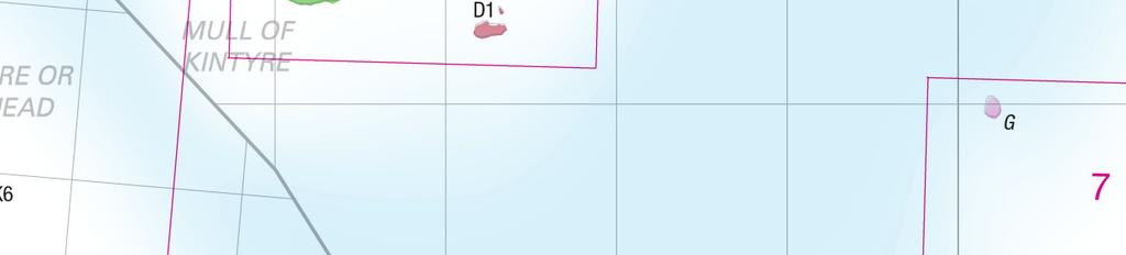
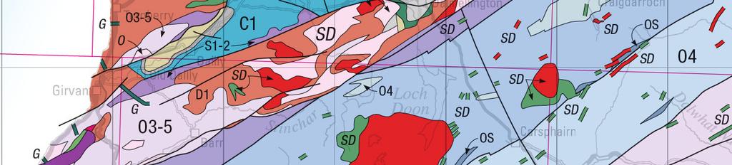
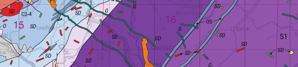
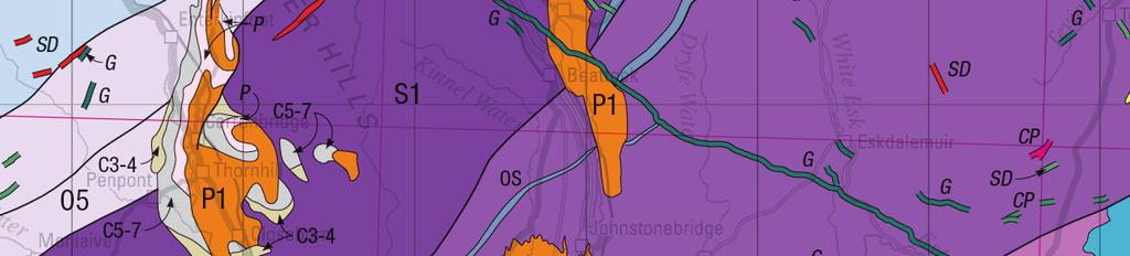
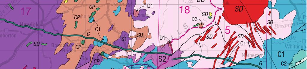
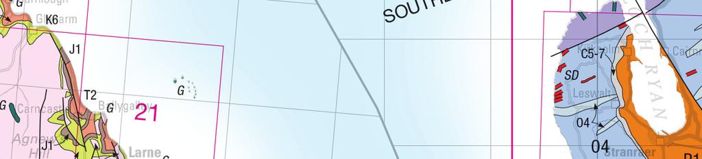
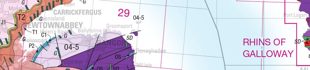
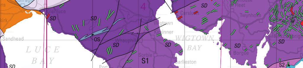
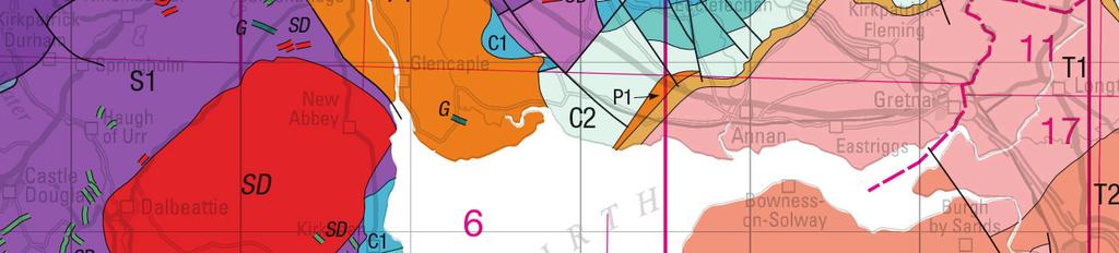
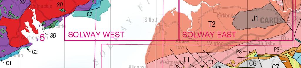
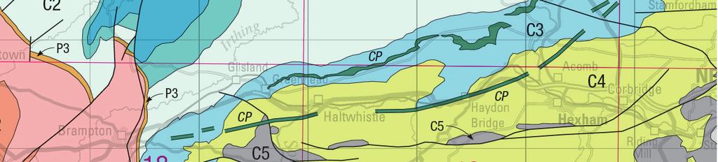
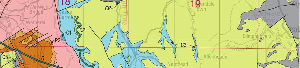
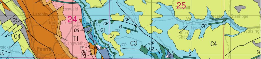
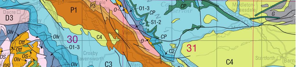
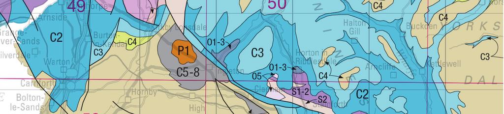
3 letters and numbers. Again this echoes back to the first edition where sedimentary units in England and Wales were labelled with letters. Rather than reinstate these, as they did not include the Precambrian, an existing alternative scheme was adopted and modified. Here the initial letter of each geological period is used as the primary identifier, thus Ordovician rocks are labelled with an O, Carboniferous with a C avoiding duplication by using established alternatives: E for Cambrian and K for Cretaceous. Within each period, units are numbered sequentially upwards, based on the chronostratigraphy or lithostratigraphy, whichever is most practicable, so that rocks which are the same age or approximately equivalent have the same number. A further benefit of this scheme is its flexibility; in future editions of the map it will easy to revise the stratigraphy by adding or removing units as appropriate. The digital vector data for the earlier 4 th edition Bedrock (and 1 st edition Quaternary) are both available free of charge for non-commercial uses from the BGS website at: It is planned to make the new 5 th edition Bedrock geological data similarly available as soon as possible. The new maps (flat or folded) and booklets are available separately from BGS, price 10 each or 15 for a map and accompanying booklet package; and the folded map and booklet come in a plastic wallet. sales@bgs.ac.uk {image for Figure 1 plus caption} Figure 1 The bedrock geology map of the UK, 5 th edition, North and South. Geoscientist_625k_Chart_final.doc 3 last revised: 7-Nov-07
4 Stratigraphical Charts of the UK The Stratigraphical Charts for northern and southern Britain, writes Colin Waters, are produced by the British Geological Survey in collaboration with the Geological Society Stratigraphy Commission. The two charts present, in total, 28 lithostratigraphical columns for onshore regions of England, Scotland, Wales, Northern Ireland, the Isle of Man and offshore regions. The onshore regions broadly correspond to the extents of the BGS Regional Guide Series and the offshore equate to either single or combined UK Offshore Regional Report Series areas. They are intended to complement the new 1: scale bedrock geological maps and provide a stimulating teaching aid and reference chart for professional geoscientists. The concept for the charts evolved from the Stratigraphical Table of Germany (Menning & German Stratigraphic Commission, 2002). As with the German chart, the aim is to present regional idealised lithostratigraphical columns, scaled against geological time. The time-scale used, the BGS Geological Time Chart 2007, is based upon the International Commission on Stratigraphy (ICS) A Geologic Time Scale 2004 (Gradstein et al., 2004). Modifications have included the presentation of the British regional stage nomenclatures in the Carboniferous and Ordovician, in addition to the international names. Also, Quaternary and Tertiary (informal term) have been reinstated, with the former shown as a System, with a base at 2.6 Ma, following decisions approved by the International Union of Quaternary Research (INQUA) and ICS in Presenting the stratigraphical columns against a time-scale, rather than the traditional approach of displaying thickness, provides an opportunity to visualise, perhaps for the first time, the duration of units, and especially, the great amount of geological time that is represented by gaps in the succession. To maximise the level of detail, it has been necessary to have several scales: most of the Phanerozoic is shown at 1 cm = 10 Ma, although the Quaternary and the Precambrian are shown at larger and smaller scale, respectively. Geoscientist_625k_Chart_final.doc 4 last revised: 7-Nov-07
5 The stratigraphical nomenclature used on the charts is that formally defined in the BGS Stratigraphical Framework Reports ( and the BGS Lexicon of Named Rock Units ( The columns typically present group and formation nomenclatures. It has not been possible to present all the multitude of approved lithostratigraphical terms on the charts. Decisions have been made by the authors to present either the most representative or most widely known successions for each region. The lithostratigraphical units are coloured according to the dominant environment of deposition for that unit. This demonstrates the lateral extent of depositional environments across Britain and how environments have evolved with time. Symbols are used to denote key characteristics of the units, such as the presence of significant coal or evaporite deposits. Although designed to present the sedimentary and volcanic successions, the charts also display the extent (spatial and temporal) of the main intrusive igneous phases and tectonic events. The unfolded charts are available from BGS, price 10 Stratigraphical chart of the UK: Southern Britain 1 st Edition ISBN and Stratigraphical chart of the UK: Northern Britain 1 st Edition ISBN Ref: Gradstein, F M, Ogg, J G, Smith, A G, et al A Geologic Time Scale: Cambridge University Press, 500pp. Menning, M and German Stratigraphic Commission A geologic time scale 2002, in: German Stratigraphic Commission (ed,), Stratigraphic Table of Germany {Image for Figure 2 plus caption} Figure 2 Extract of the Stratigraphical Chart for Southern Britain showing the level of chronostratigraphical and lithostratigraphical details. Geoscientist_625k_Chart_final.doc 5 last revised: 7-Nov-07
6 175.6 Scale: 1 cm = 10 Ma PHANEROZOIC Mesozoic Jurassic Triassic Permian Late Mid Lopingian Guadalupian Cisuralian Toarcian Pliensbachian Sinemurian Hettangian Rhaetian Norian Carnian Ladinian Anisian Olenekian Induan Changhsingian Wuchiapingian Capitanian Wordian Roadian Kungurian Artinskian Sakmarian Lias Penarth Mercia Preesall Halite Sherwood Sandstone Blue Anchor Elswick Warton Halite Dowbridge Leyland Ormskirk Sst Fm St Bees Sandstone Barrowmouth Mdst Fm Cumbrian St Bees Coast Evaporite Fm Appleby Manchester Marls Collyhurst Sandstone (g, a) (h) (h) Lias Penarth Westbury Mercia Sherwood Sandstone Cumbrian Coast Appleby Lilstock Blue Anchor Branscombe Sidmouth Tarporley Siltstone Helsby Sandstone Wilmslow Sandstone Fm Chester Pebble Beds Fm Kinnerton Sandstone Fm Manchester Marls Collyhurst Sandstone Bold (g (h) Palaeozoic Carboniferous Pennsylvanian Mississippian Late Mid Late Mid Gzhelian Kasimovian Moscovian Bashkirian Serpukhovian Visean Tournaisian Asselian Namurian Westphalian Stephanian Westphalian D Bolsovian Duckmantian Langsettian Yeadonian Marsdenian Kinderscoutian Alportian Chokierian Arnsbergian Pendleian Brigantian Asbian Holkerian Arundian Chadian Courceyan VARISCAN Kidston Bisat Garwood Tormentil Volcanics VARISCAN Warwickshire Gp Pennine Coal Measures Rossendale Fm Hebden Fm Millstone Grit Craven Bowland High Halesowen Etruria Pennine Lower, Middle & Upper Coal Measures fms Marsden Samlesbury Silsden Pendleton Bowland Shale Pendleside Limestone Fm Hodderense Limestone Fm Hodder Clitheroe Limestone Fm Chatburn Limestone 359.2


7
Geologica Acta: an international earth science journal ISSN: Universitat de Barcelona España
 Geologica Acta: an international earth science journal ISSN: 1695-6133 geologica-acta@ija.csic.es Universitat de Barcelona España Heckel, P.H.; Clayton, G. The Carboniferous System. Use of the new official
What can lithostratigraphy do for you?
 What can lithostratigraphy do for you? John Powell* outlines research carried out through the BGS Stratigraphy Committee, and collaboration with the Geological Society Stratigraphy Commission** Peter Gutteridge
THE COMMISSION FOR THE GEOLOGICAL MAP OF THE WORLD
 IGCP Paris February 19, 2014 UNESCO THE COMMISSION FOR THE GEOLOGICAL MAP OF THE WORLD Some milestones in the life of CGMW 1881: 2 nd IGC (Bologna) Creation of the Commission for the International Geological
RELINQUISHMENT REPORT. License P1546 Block April 2009
 RELINQUISHMENT REPORT License P1546 Block 110-01 14 April 2009 Sherritt International Oil and Gas Limited 2000, 425-1 st street S.W., Calgary, Alberta Canada T2P 3L8 Telephone (403) 260-2900 Fax (403)
Chapter 16 Irish Sea (including Kish Bank) D. I. JACKSON, N. S. JONES & C. N. WATERS
 D. I. JACKSON, N. S. JONES & C. N. WATERS") Chapter 16 Irish Sea (including Kish Bank) D. I. JACKSON, N. S. JONES & C. N. WATERS A thick and relatively complete succession of Carboniferous rocks of Tournaisian to Westphalian age, together with a
Chapter 16 Irish Sea (including Kish Bank) D. I. JACKSON, N. S. JONES & C. N. WATERS A thick and relatively complete succession of Carboniferous rocks of Tournaisian to Westphalian age, together with a
Chapter 11 Craven Basin and southern Pennines C. N. WATERS, N.S. JONES, J. D. COLLINSON and C. J. CLEAL
 Chapter 11 Craven Basin and southern Pennines C. N. WATERS, N.S. JONES, J. D. COLLINSON and C. J. CLEAL Carboniferous rocks within this area occupy the region contiguous with the northern Pennines to the
Homework 2: Due Wednesday Geochronology
 EESC 2200 The Solid Earth System Homework 2: Due Wednesday Geochronology 29 Sep 08 Relative Age Absolute Age NY Times and Science, 26 September 2008, Jonathan O Niel Absolute vs. relative age Field and
CUADRILLA RESOURCES LTD
 CUADRILLA RESOURCES LTD UK Shale Gas Exploration Peter Turner BSc (Wales), PhD (Leicester) CUADRILLA RESOURCES LTD Cuadrilla Resources Limited ( Cuadrilla, CRL or the Company ) was formed in September
Hydrocarbon plays of the Mid North Sea High: an integrated seismic and basin modelling study
 Hydrocarbon plays of the Mid North Sea High: an integrated seismic and basin modelling study Stephen Corfield, Julian Moore, Maurice Bamford, Andrew Barnwell and Patrick Barnard -OGA Frontier exploration
INTERNATIONAL STRATIGRAPHIC CHART International Commission on Stratigraphy
 ICS INTERNATIONAL STRATIGRAPHIC CHART International Commission on Stratigraphy them Quaternary M e s o z o i c C e n o z o i c Cretaceous Paleogene Neogene Holocene Pleistocene Pliocene Miocene Oligocene
GEOLOGY - GL4 INTERPRETING THE GEOLOGICAL RECORD
 Candidate Name Centre Number 2 Candidate Number GCE A level 1214/01 GEOLOGY - GL4 INTERPRETING THE GEOLOGICAL RECORD A.M. MONDAY, 21 June 2010 2 hours Section A 1. 2. 3. 15 15 15 1214 01 01 4. 15 Section
Section 7. Reading the Geologic History of Your Community. What Do You See? Think About It. Investigate. Learning Outcomes
 Chapter 3 Minerals, Rocks, and Structures Section 7 Reading the Geologic History of Your Community What Do You See? Learning Outcomes In this section, you will Goals Text Learning Outcomes In this section,
Risks of environmental contamination from proposed fracking in the Fylde, Lancashire
 Risks of environmental contamination from proposed fracking in the Fylde, Lancashire A short slideshow Professor David Smythe November 2014 1 Introduction Shale is a very common kind of rock, found in
GY 111: Physical Geology
 UNIVERSITY OF SOUTH ALABAMA GY 111: Physical Geology Lecture 21: Rock Deformation Instructor: Dr. Douglas W. Haywick Last Time A) How long is long? B) Geological time divisions Web notes 20 Geological
A typical rock formation. Relative dating: some principles to follow... Wednesday, October 26, 11
 A typical rock formation Relative dating: some principles to follow... Wednesday, October 26, 11 Principle of superposition Principle of original horizontality Principle of lateral continuity Principle
GCE A level 1214/01 GEOLOGY GL4 Interpreting the Geological Record
 Surname Centre Number Candidate Number Other Names 2 GCE A level 1214/01 GEOLOGY GL4 Interpreting the Geological Record P.M. MONDAY, 6 June 2016 2 hours S16-1214-01 For s use Question Maximum Mark Mark
GEOLOGY GL1 Foundation Unit
 Candidate Name Centre Number Candidate Number 2 General Certificate of Education Advanced Subsidiary/Advanced 451/01 GEOLOGY GL1 Foundation Unit P.M. THURSDAY, 10 January 2008 (1 hour) Examiner Question
Lab 4: Structures and Geologic Maps
 Key Questions: GEOL 1311 Earth Science Lab 4 Structures and Geologic Maps What shapes do rock bodies take in the Earth? How do two-dimensional visualizations of the Earth, such as maps and cross-sections
Tuesday 10 June 2014 Afternoon
 Tuesday 10 June 2014 Afternoon A2 GCE GEOLOGY F795/01 Evolution of Life, Earth and Climate *1242977619* Candidates answer on the Question Paper. OCR supplied materials: None Other materials required: Electronic
Structural Geology of the Mountains
 Structural Geology of the Mountains Clinton R. Tippett Shell Canada Limited, Calgary, Alberta clinton.tippett@shell.ca INTRODUCTION The Southern Rocky Mountains of Canada (Figure 1) are made up of several
GCE A level 1215/03 GEOLOGY - GL5 THEMATIC UNIT 3 GEOLOGICAL EVOLUTION OF BRITAIN
 Surname Other Names Centre Number 2 Candidate Number GCE A level 1215/03 GEOLOGY - GL5 THEMATIC UNIT 3 GEOLOGICAL EVOLUTION OF BRITAIN P.M. FRIDAY, 10 June 2011 ONE of TWO units to be completed in 2 hours
1 Introduction f. m. gradstein
 Part I Introduction 1 Introduction f. m. gradstein The development of new dating methods and the extension of existing methods has stimulated the need for a comprehensive review of the geologic time scale.
454/01 GEOLOGY GL4 EXTENSION GEOLOGY. P.M. FRIDAY, 14 June (2 Hours)
") WELSH JOINT EDUCATION COMMITTEE General Certificate of Education Advanced CYD-BWYLLGOR ADDYSG CYMRU Tystysgrif Addysg Gyffredinol Uwch 454/01 GEOLOGY GL4 EXTENSION GEOLOGY P.M. FRIDAY, 14 June 2002 (2
WELSH JOINT EDUCATION COMMITTEE General Certificate of Education Advanced CYD-BWYLLGOR ADDYSG CYMRU Tystysgrif Addysg Gyffredinol Uwch 454/01 GEOLOGY GL4 EXTENSION GEOLOGY P.M. FRIDAY, 14 June 2002 (2
Licence P1524 Relinquishment Report. RWE DEA June 2011
 1. Header Licence Number: P1524 Licence Round: 24 th 2007 Licence Type: Promote Blocks: 42/2b, 42/3, 42/4 Licencees: RWE Dea UK SNS Limited 70% (Op), Sterling Resources (UK) Limited 30% Work Programme:
North Greenland collection of oblique aerial photographs - (Twin Otter photos)
") North Greenland collection of oblique aerial photographs - (Twin Otter photos) The Geological Survey of Greenland (now part of the Geological Survey of Denmark and Greenland: GEUS) carried out a systematic
North Greenland collection of oblique aerial photographs - (Twin Otter photos) The Geological Survey of Greenland (now part of the Geological Survey of Denmark and Greenland: GEUS) carried out a systematic
Structural Geology Lab. The Objectives are to gain experience
 Geology 2 Structural Geology Lab The Objectives are to gain experience 1. Drawing cross sections from information given on geologic maps. 2. Recognizing folds and naming their parts on stereoscopic air
Age of Earth/Geologic Time. Vocabulary
 Age of Earth/Geologic Time Vocabulary Big Ideas Geologic Time Earth Structures Identify current methods for measuring the age of Earth and its parts, including the law of superposition and radioactive
Earth History Exam. The remains of an early dinosaur could be found at reference point A. A B. B C. C D. D. page 1
 Name: Date: 1. Base your answer(s) to the following question(s) on the Earth Science Reference Tables and your knowledge of Earth science. The accompanying cross section shows undisturbed sedimentary bedrock.
The Rocks of Our Region.
 The Rocks of Our Region. BGS Timescale for the Phanerozoic Eon The Phanerozoic is the Eon where there were abundant life forms, leaving many fossils, which allow detailed correlation of geological formations.
Stratigraphy. The part of geology that deals with the formation, composition, sequence, and correlation of rocks, especially stratified rocks
 Stratigraphy The part of geology that deals with the formation, composition, sequence, and correlation of rocks, especially stratified rocks Limestone Sandstone Shale 1 Stratigraphy The part of geology
L.O: HOW GEOLOGISTS SEQUENCE EVENTS IN EARTH'S GEOLOGIC HISTORY IF NOT OVERTURNED, OLDEST ON BOTTOM, YOUNGEST ON TOP
 L.O: HOW GEOLOGISTS SEQUENCE EVENTS IN EARTH'S GEOLOGIC HISTORY IF NOT OVERTURNED, OLDEST ON BOTTOM, YOUNGEST ON TOP 1. Unless a series of sedimentary rock layers has been overturned, the bottom rock layer
RWE Dea UK SNS Limited (50%, operator) Dana Petroleum (E&P) Limited (50%)
 Dana Petroleum (E&P) Limited (50%)") 1. Licence Information Licence Number P1726 Licence Round 25 th (2008) Licence Type Traditional Blocks 43/17a & 43/18a Licensees Work Programme RWE Dea UK SNS Limited (50%, operator) Dana Petroleum (E&P)
1. Licence Information Licence Number P1726 Licence Round 25 th (2008) Licence Type Traditional Blocks 43/17a & 43/18a Licensees Work Programme RWE Dea UK SNS Limited (50%, operator) Dana Petroleum (E&P)
F794. GEOLOGY Environmental Geology ADVANCED GCE. Friday 10 June 2011 Afternoon
 ADVANCED GCE GEOLOGY Environmental Geology F794 *F711210611* Candidates answer on the question paper. OCR supplied materials: None Other materials required: Electronic calculator Ruler (cm/mm) Friday 10
Absolute Time. Part 8 Geochronology and the Time Scale
 Absolute Time Part 8 Geochronology and the Time Scale Unless otherwise noted the artwork and photographs in this slide show are original and by Burt Carter. Permission is granted to use them for non-commercial,
L27-Molecular Evolution +Evolution in Geological Time
 L27-Molecular Evolution +Evolution in Geological Time Mutations Frameshift mutations can cause major amino acid changes, resulting in genetic diseases -anemia due to unbalanced globin protein production
The principle of fossil succession allows strata in different parts of the world to be correlated, and worldwide relative ages to be worked out
 Correlating beds using index fossils Stratigraphic Classification: Piles of stratified rocks need to be classified. A formation is an easily identifiable rock unit that differs from layers above and below
Lithofacies features of Carboniferous Lower Permian strata from the Pechora Sea
 Lithofacies features of Carboniferous Lower Permian strata from the Pechora Sea E.B. Suvorova, T.V.Matveeva «I.S. Gramberg VNIIOkeangeologia», Saint-Petersburg, Russia ABSTRACT This paper shows interpreted
454/01 GEOLOGY GL4 INTERPRETING THE GEOLOGICAL RECORD. A.M. MONDAY, 12 June (2 Hours)
") Candidate Name Centre Number Candidate Number WELSH JOINT EDUCATION COMMITTEE General Certificate of Education Advanced CYD-BWYLLGOR ADDYSG CYMRU Tystysgrif Addysg Gyffredinol Uwch 454/01 GEOLOGY GL4 INTERPRETING
Candidate Name Centre Number Candidate Number WELSH JOINT EDUCATION COMMITTEE General Certificate of Education Advanced CYD-BWYLLGOR ADDYSG CYMRU Tystysgrif Addysg Gyffredinol Uwch 454/01 GEOLOGY GL4 INTERPRETING
The Triassic Main Buntsandstein play New prospectivity in the Dutch northern offshore
 The Triassic Main Buntsandstein play New prospectivity in the Dutch northern offshore Mesozoic Resource Potential in the Southern Permian Basin, 8-9 Sept 2016, London Top RBMVL (mtvd) Marloes Kortekaas¹,
UK data for geothermal resource assessments
 UK data for geothermal resource assessments Jon Busby UK data for geothermal resource assessments Outline 1. Data availability 2. Sub-surface temperatures 3. The EGS resource 4. Deep saline aquifers Publicly
The Triassic Main Buntsandstein play in the Dutch northern offshore
 Poster #7 The Triassic Main Buntsandstein play in the Dutch northern offshore New prospectivity away from the main fairway Marloes Kortekaas*, Bastiaan Jaarsma, Ulf Böker, Cas van der Kooij and Eveline
Structural Geology Lab. The Objectives are to gain experience
 Geology 2 Structural Geology Lab The Objectives are to gain experience 1. Drawing cross sections from information given on geologic maps. 2. Recognizing folds and naming their parts on stereoscopic air
Relative Dating Exercises
 Laboratory 1 Relative Dating Exercises Pamela J. W. Gore Department of Geology, Georgia Perimeter College Clarkston, GA 30021 Copyright 1998-2005 Pamela J. W. Gore Examine the geologic cross sections which
Extended Abstract for presentation at EAGE Meeting Paris 13/ History of Norwegian Petroleum Exploration and its impact on Norwegian Geosciences
 Extended Abstract for presentation at EAGE Meeting Paris 13/6 2017 History of Norwegian Petroleum Exploration and its impact on Norwegian Geosciences Knut Bjørlykke University of Oslo Abstract Before petroleum
Robert S. Sawin Stratigraphic Research Section Kansas Geological Survey. Open-File Report
 Copies of Archived Correspondence Pertinent to the Decision to Classify the Exposure at Point of Rocks, Morton County, Kansas, as Jurassic by the Kansas Geological Survey in 1967 Robert S. Sawin Stratigraphic
Geologic History of Texas: The Making of Texas Over 1.5 Billion Years
 # 4 Geologic History of Texas: The Making of Texas Over 1.5 Billion Years Dr. Richard Kyle March 24, 2000 Produced by and for Hot Science - Cool Talks by the Environmental Science Institute. We request
Economic information for planning
 Economic information for planning Fiona McEvoy Economic Geologist and GIS Specialist Kingsley Dunham Centre Keyworth Nottingham NG12 5GG Tel 0115 936 3100 Overview Original MIST project environmentally
Lab 2 Geological Time and Fossil Samples
 Geol G308 Paleontology and Geology of Indiana Name: Lab 2 Geological Time and Fossil Samples This lab has two components: understanding geological time scales and choosing fossil samples from the IU Paleontology
GEOLOGIC HISTORY DIAGRAMS
 NAME: Log onto YouTube and search for jocrisci channel. GEOLOGIC HISTORY DIAGRAMS (Video 6.1) 1. Given a geologic cross section, you must be able to recognize folding, faulting, intrusions, unconformities,
454/01 GEOLOGY GL4 INTERPRETING THE GEOLOGICAL RECORD. P.M. THURSDAY, 17 June (2 Hours)
") Candidate Name Centre Number Candidate Number WELSH JOINT EDUCATION COMMITTEE General Certificate of Education Advanced CYD-BWYLLGOR ADDYSG CYMRU Tystysgrif Addysg Gyffredinol Uwch 454/01 GEOLOGY GL4 INTERPRETING
Candidate Name Centre Number Candidate Number WELSH JOINT EDUCATION COMMITTEE General Certificate of Education Advanced CYD-BWYLLGOR ADDYSG CYMRU Tystysgrif Addysg Gyffredinol Uwch 454/01 GEOLOGY GL4 INTERPRETING
Geological & Geophysical Interpretation of ZTEM EM and Magnetic Survey. Kemess Project, BC. for AuRico Metals Inc. September, 2016 Nicole Pendrigh
 Geological & Geophysical Interpretation of ZTEM EM and Magnetic Survey Kemess Project, BC for AuRico Metals Inc. September, 2016 Nicole Pendrigh SUMMARY REPORT Regional setting Located in North central
The Triassic hydrocarbon potential of the northern Dutch offshore -
 The Triassic hydrocarbon potential of the northern Dutch offshore - The over-looked upside Marloes Kortekaas 1, Kees van Ojik 1, Ulf Böker 2, Marloes Jongerius 1 1) EBN B.V. 2) Panterra Geoconsultants
GEOLOGIC MAPS PART II
 EARTH AND ENVIRONMENT THROUGH TIME LABORATORY - EES 1005 LABORATORY FIVE GEOLOGIC MAPS PART II Introduction Geologic maps of orogenic belts are much more complex than maps of the stable interior. Just
YEAR 7 REVISION BOOKLET
 YEAR 7 REVISION BOOKLET Assessment checklist 1. To be able to define Geography. 2. Give examples of what we study in geography 3. Group what we study into the three major areas of geography 4. To be able
Structural Analysis of Rocks and Regions 2017 Maps and cross-sections
 Structural Analysis of Rocks and Regions 2017 Maps and cross-sections The practicals in SARR will introduce you to (or remind you of) the tools and skills that are typically used to reconstruct and quantify
Fossils: evidence of past life
 Fossils: evidence of past life Remains or traces of prehistoric life Petrified Cavities and pores are filled with precipitated mineral matter Petrified Formed by replacement Cell material is removed and
GCE AS/A level 1211/01 GEOLOGY GL1 Foundation Unit
 Surname Centre Number Candidate Number Other Names 2 GCE AS/A level 1211/01 GEOLOGY GL1 Foundation Unit S15-1211-01 A.M. MONDAY, 11 May 2015 1 hour For s use Question Maximum Mark 1. 15 2. 14 Mark Awarded
Geology Map Extracts. Geology Map Extracts. Report prepared for: Orkney Sustainable Energy Ltd 6 North End Road Stromness Orkney KW16 3AG
 Report prepared for: Orkney Sustainable Energy Ltd 6 North End Road Stromness Orkney KW16 3AG Geology Map Extracts This report is designed for users carrying out preliminary site assessments who require
NAME HOMEWORK ASSIGNMENT #3 MATERIAL COVERS CHAPTERS 8, 9, 10, 11
 NAME HOMEWORK ASSIGNMENT #3 MATERIAL OVERS HAPTERS 8, 9, 10, 11 Assignment is due the beginning of the class period on November 23, 2004. Answers for each chapter will be discussed in class, as Exam #3
UK Field Training Courses
 UK Field Training Courses Bespoke courses for E&P companies For individual companies and/or partnerships Reservoir and exploration sedimentology oriented Integrated with company sedimentologist if desired
Correlation chart for Late Devonian to Permian stratified rocks of the Maritimes Basin, Atlantic Canada.
 Correlation chart for Late Devonian to Permian stratified rocks of the Maritimes Basin, Atlantic Canada. by John W.F. Waldron 1, Peter S. Giles 2, and Alison K. Thomas 1 1University of Alberta 2 Geological
AAPG European Region Annual Conference Paris-Malmaison, France November RESOURCES PERSPECTIVES of the SOUTHERN PERMIAN BASIN AREA
 AAPG European Region Annual Conference Paris-Malmaison, France 23-24 November 2009 RESOURCES PERSPECTIVES of the SOUTHERN PERMIAN BASIN AREA J.C. DOORNENBAL, TNO Built, Environment and Geosciences, Geological
Iowa s Precambrian and Cambrian. University of Northern Iowa Dr. Chad Heinzel
 Iowa s Precambrian and Cambrian University of Northern Iowa Dr. Chad Heinzel Concept of Geologic Formations A body/layer of rock that consists dominantly of a certain lithologic rock type Maybe combined
SAMPLE QUESTIONS FOR GEOLOGY 103, TEST 1
 SAMPLE QUESTIONS FOR GEOLOGY 103, TEST 1 The correct answers are listed at the bottom (no peeking!). These questions are to give you an idea of the type of questions that will be asked. They are not a
On the Geologic Time Scale 2008
 1 On the Geologic Time Scale 2008 Felix M.Gradstein 1, James G.Ogg 2, and Martin van Kranendonk 3 1. Museum of Natural History Geology Department University of Oslo N-0318 Oslo, Norway E-mail: felix.gradstein@nhm.uio.no
Name. GEOL.5220 Structural Geology Faults, Folds, Outcrop Patterns and Geologic Maps. I. Properties of Earth Materials
 I. Properties of Earth Materials GEOL.5220 Structural Geology Faults, Folds, Outcrop Patterns and Geologic Maps Name When rocks are subjected to differential stress the resulting build-up in strain can
1. The timeline below represents time on Earth from the beginning of the Paleozoic Era Ato the present B.
 Name Roy G Biv 1. The timeline below represents time on Earth from the beginning of the Paleozoic Era Ato the present B. Which numbered position best represents the time when humans first appeared in the
Serica Energy (UK) Limited. P.1568 Relinquishment Report. Block 110/2d. UK East Irish Sea
 Limited. P.1568 Relinquishment Report. Block 110/2d. UK East Irish Sea") Serica Energy (UK) Limited P.1568 Relinquishment Report Block 110/2d UK East Irish Sea August 2012 1 Header Licence: P.1568 Round: 25th UK Licensing Round Block: 110/2d Licence Type: Traditional Equity:
Serica Energy (UK) Limited P.1568 Relinquishment Report Block 110/2d UK East Irish Sea August 2012 1 Header Licence: P.1568 Round: 25th UK Licensing Round Block: 110/2d Licence Type: Traditional Equity:
Characterisation of Quaternary deposits in West Cumbria using the concept of domains: A case study
 Characterisation of Quaternary deposits in West using the concept of domains: a case study Characterisation of Quaternary deposits in West using the concept of domains: A case study Jon Merritt Quaternary
As compaction and cementation of these sediments eventually occur, which area will become siltstone? A) A B) B C) C D) D
 A B) B C) C D) D") 1. A student obtains a cup of quartz sand from a beach. A saltwater solution is poured into the sand and allowed to evaporate. The mineral residue from the saltwater solution cements the sand grains together,
1. A student obtains a cup of quartz sand from a beach. A saltwater solution is poured into the sand and allowed to evaporate. The mineral residue from the saltwater solution cements the sand grains together,
THERMAL MATURITY ASSESSMENT OF MIDDLE ROCKS AND HEAT FLOW MODELING IN AGATOVO-SUHINDOL AREA (CENTRAL NORTH BULGARIA)
") DOI: http://dx.doi.org/10.18509/agb.2015.01 UDC: 551.761:550.832.6.05(497.2) COBISS: THERMAL MATURITY ASSESSMENT OF MIDDLE TRIASSIC ROCKS AND HEAT FLOW MODELING IN AGATOVO-SUHINDOL AREA (CENTRAL NORTH
DOI: http://dx.doi.org/10.18509/agb.2015.01 UDC: 551.761:550.832.6.05(497.2) COBISS: THERMAL MATURITY ASSESSMENT OF MIDDLE TRIASSIC ROCKS AND HEAT FLOW MODELING IN AGATOVO-SUHINDOL AREA (CENTRAL NORTH
Unit 5: Earth s History Practice Problems
 Name: Date: 1. Which bedrock would be most likely to contain fossils? A. Precambrian granite B. Cambrian shale C. Pleistocene basalt D. Middle-Proterozoic quartzite 6. Base your answer(s) to the following
43 Misconceptions About Spiders: Teaching a Difficult Concept to Preschool and Elementary Children
 1 Michigan s Ride on the North 5 38 American Plate 19 25 32 Quantitative and Qualitative Differences in Science Writing With a Writing Template Intervention The New Reality of Higher Education: Technology
Tuesday 6 June 2017 Afternoon
 Oxford Cambridge and RSA Tuesday 6 June 2017 Afternoon A2 GCE GEOLOGY F794/01 Environmental Geology *6783378785* Candidates answer on the Question Paper. OCR supplied materials: None Other materials required:
Block 43B - Onshore Oman
 Block 43B - Onshore Oman SUMMARY Block 43B is an 11,967 km 2 area located along the coastal area of Oman north of the Hajar Mountains. This is an unexplored region, both geographically and stratigraphically.
The Building of the NYC Region
 The Building of the NYC Region Definitions Fall Line marks the area where an upland region (continental bedrock) and a coastal plain meet Piedmont the plateau region of the eastern United States which
A Joint European GIS Under Construction: The 1:5 Million International Geological Map of Europe and Adjacent Areas (IGME 5000)
") Abstract 2001 Annual Conference of the International Association for Mathematical Geology Technical Program - Session I (Poster) Building National and Regional Geologic Map Databases A Joint European GIS
Abstract 2001 Annual Conference of the International Association for Mathematical Geology Technical Program - Session I (Poster) Building National and Regional Geologic Map Databases A Joint European GIS
Does the SDCP need inputs from geology?
 The British Geological Survey s Experience and Expertise in Supporting Projects such as the Sirte Depression Connection Project David Ovadia Director of International Kingsley Dunham Centre Keyworth Nottingham
Theory Paper (Paper version of on-screen assessment)
") Surname Other Names Centre Number 0 Candidate Number GCSE 4250/01 GEOLOGY Theory Paper (Paper version of on-screen assessment) A.M. FRIDAY, 18 May 2012 1 1 2 hours ADDITIONAL MATERIALS In addition to this
Surname Other Names Centre Number 0 Candidate Number GCSE 4250/01 GEOLOGY Theory Paper (Paper version of on-screen assessment) A.M. FRIDAY, 18 May 2012 1 1 2 hours ADDITIONAL MATERIALS In addition to this
Hydrocarbon potential of the Lower Carboniferous in the Dutch northern offshore
 Hydrocarbon potential of the Lower Carboniferous in the Dutch northern offshore Palaeozoic Plays of Northwest Europe, 26-27 May 2016, London Marten ter Borgh, Bastiaan Jaarsma, Walter Eikelenboom and Eveline
Section 5. Rock Units and Your Community. What Do You See? Think About It. Investigate. Learning Outcomes
 Chapter 3 Minerals, Rocks, and Structures Section 5 Rock Units and Your Community What Do You See? Learning Outcomes In this section, you will Recognize that rocks are arranged in Earth s crust as well-defined
Unconformities are depositional contacts that overlie rocks distinctly older than they are. They are often called gaps in the sedimentary record.
 UNCONFORMITIES Unconformities are depositional contacts that overlie rocks distinctly older than they are. They are often called gaps in the sedimentary record. The contact represents time when no sediment
Timing of Geologic Events. Geologic Time Terms. Laws / Principles of Stratigraphy
 Geologic Time Terms Hadean Archean Proterozoic Phanerozoic Paleozoic Mesozoic Cenozoic(Tertiary) Cambrian Unconformity Angular unconformity Half-life Alpha particle Beta particle Gamma ray Neutron UT How
Remains or traces of prehistoric life
 Fossils: evidence of past life Remains or traces of prehistoric life Petrified Cavities and pores are filled with precipitated p mineral matter Petrified Formed by replacement Cell material is removed
Norwegian Interactive Offshore Stratigraphic Lexicon: Cretaceous Mike Charnock StatoilHydro Geo Workshop Meeting NPD 16 October 2009
 Classification: Internal Status: Draft Norwegian Interactive Offshore Stratigraphic Lexicon: Cretaceous Mike Charnock StatoilHydro Geo Workshop Meeting NPD 16 October 2009 2 NORLEX: Cretaceous Overview
Geologic Time. Geologic Events
 Geologic Time Much of geology is focused on understanding Earth's history. The physical characteristics of rocks and minerals offer clues to the processes and conditions on and within Earth in the past.
Key Elements of the Petroleum Systems of the Rockall and Slyne-Erris Basins
 Key Elements of the Petroleum Systems of the Rockall and Slyne-Erris Basins Bandon Corrib Dooish Atlantic Ireland Conference, Dublin, 1 st - 2 nd November 2016 Rockall and Slyne-Erris Basins Only 11 exploration
Petroleum Geology of the North Sea
 Petroleum Geology of the North Sea Basic Concepts and Recent Advances EDITED BY K.W. GLENNIE Honorary Professor, Department of Geology & Petroleum Geology, University of Aberdeen; Formerly Shell UK Exploration
Geology Test Review Answers
 Name: Geology Test Review Answers Core: Fill in the blanks: 1. Sediments get compacted and cemented into sedimentary rock. 2. Igneous rocks can be intrusive or extrusive from a volcano. 3. Adding heat
Conodont Colour Alteration pattern in the Carboniferous of the Craven Basin and adjacent areas, northern England
 PROCEEDINGS OF THE YORKSHIRE GEOLOGICAL SOCIETY, VOL. 58, PART 1, PP. 1 8, 2010 Conodont Colour Alteration pattern in the Carboniferous of the Craven Basin and adjacent areas, northern England I. METCALFE
PETROLEUM GEOLOGY OF THE RUSSIAN FAR-EAST
 Contents - 1 PETROLEUM GEOLOGY OF THE RUSSIAN FAR-EAST CONTENTS PART I: INTRODUCTION TO THE RUSSIAN FAR EAST AND ITS STRUCTURAL DEVELOPMENT. Chapter 1. The Russian Far East: Introduction and Infrastructure.
Sequence Biostratigraphy and Depositional Modelling of the Pennsylvanian-Permian Belloy Formation Peace River Embayment, Alberta Canada
 Page No. 104-1 Sequence Biostratigraphy and Depositional Modelling of the Pennsylvanian-Permian Belloy Formation Peace River Embayment, Alberta Canada Lindsay A. Dunn* and Charles M. Henderson Applied
MUHAMMAD S TAMANNAI, DOUGLAS WINSTONE, IAN DEIGHTON & PETER CONN, TGS Nopec Geological Products and Services, London, United Kingdom
 Geological and Geophysical Evaluation of Offshore Morondava Frontier Basin based on Satellite Gravity, Well and regional 2D Seismic Data Interpretation MUHAMMAD S TAMANNAI, DOUGLAS WINSTONE, IAN DEIGHTON
Efficient Chrono-Stratigraphic Database Structure in GIS
 Efficient Chrono-Stratigraphic Database Structure in GIS Carlos Gabriel Asato, Servicio Geológico Minero Argentino Buenos Aires, Argentina. E-mail gasat@secind.mecon.gov.ar Abstract In recent years the
3. GEOLOGY. 3.1 Introduction. 3.2 Results and Discussion Regional Geology Surficial Geology Mine Study Area
 3. GEOLOGY 3.1 Introduction This chapter discusses the baseline study of the geology and mineralization characteristics of the mine study area. The study consolidates existing geological data and exploration
Unit 6: Interpreting Earth s History
 Unit 6: Interpreting Earth s History How do we know that the Earth has changed over time? Regent s Earth Science Name: Topics Relative Dating Uniformitarianism Superposition Original Horizontality Igneous
TIME. Does not give the. Places events in sequencee 1 st, 2 nd, 3 rd. Gives a. exact date of an event. event. Radioactive Dating.
 Geologic History TIME Places events in sequencee 1 st, 2 nd, 3 rd Does not give the exact date of an event Gives a date or time of an event Uses the Law of Superposition Radioactive Dating Youngest Law
European Union Can you label the twenty-seven countries of the EU on the map attached? (Do not revise the capitals.)
") NAME: FORM: YEAR 5 SUMMER EXAM REVISION QUESTIONS 2016 The exam will be forty minutes long. Answers will be short sentences or just one-word answers. The exam will be based upon the work that you have
NAME: FORM: YEAR 5 SUMMER EXAM REVISION QUESTIONS 2016 The exam will be forty minutes long. Answers will be short sentences or just one-word answers. The exam will be based upon the work that you have
BRITISH ROCKS and the GEOLOGIC TIME SCALE 28/01/2018. Rocks are divided into 3 types, based on how they form.
 BRITISH ROCKS and the GEOLOGIC TIME SCALE Cross bedding, rip up fragments and small pebbles in sandstone. Liverpool Anglican Cathedral wall, right side, near rock outcrop. We are lucky in Britain in that
1 Licence Number and Block Details
 Licence Number and Block Details 1 Licence Number and Block Details Table 1.1: Licence details. Licence Number: P1343 Licence Round: 23rd Round Licence Type: Traditional Block(s): 43/30b, 48/05a & 49/01b