GeoSteering
|
|
|
- Cameron Harrell
- 5 years ago
- Views:
Transcription


1 GeoSteering


2 GeoSteering Significance The geosteering uses real-time geological parameters to clarify various uncertainties and effectively control the landing and direction of the well trajectory, and adjust the well trajectory to travel through the target layer to achieve the purpose of improving the drilling rate. Reservoir Depth Formation Dip Uncertainty Formation Thickness Lithological Change Geosteering Method Stratigraphic model prediction curve method The geosteering uses real-time geological parameters to clarify various uncertainties and effectively control the landing and direction of the well trajectory, and adjust the well trajectory to travel through the target layer to achieve the purpose of improving the drilling rate. GR imaging layer interface method The formation morphology and formation apparent dip (ADIP) can be determined. Under Up GR Down GR Up GR Up Establishing a stratigraphic model Adjusting the stratigraphic model Adjust the formation model, the prediction curve is consistent with the measured curve

 Data table (.xls) Logging data receiving method File access form Real-time acquisition of Seismic Data, LWD Data, Logging Data, real-time display of data and channel connection status.")
3 Technology Features Seismic, LWD, Logging Data access Seismic LWD Logging Data Seismic, LWD, Logging Data Reception Transmission protocol: WITS Dictionary Management: Open Management Support instruments: Baker Hughes, Halliburton, Schlumberger, COSL, GE, etc. COM port link connection Transmit Receive Software Seismic, LWD data receiving transmission channel: COM port: baud rate and data bit TCP/IP protocol: IP and port Logging data reception Database Access (.mdb) Data table (.xls) Logging data receiving method File access form Real-time acquisition of Seismic Data, LWD Data, Logging Data, real-time display of data and channel connection status. Multi-mode projection The software can be project based on the profile orientation or the trajectory profile. Automatic projection of adjacent wells The adjacent well stratigraphic interface and logging curve depth are dynamically corrected to the current horizontal well projection profile based on formation occurrence. Adjacent well 1 Adjacent well 1 Profile Orientation East South Trajectory Profile Multiple modeling methods TVD Real Drilling Track Construction diagram modeling Multi-well comparison modeling Seismic slice modeling Construction dip modeling The user selects one of the methods suitable for this block to establish a formation model. Construction diagram modeling: Establish an initial model based on the target layer (top / bottom) interface. NO X Y TVDss NO X Y TVDss


4 Technology Features Multi-well comparison modeling: Establish an initial model based on the destination layer interface of multiple adjacent well projections. Seismic slice modeling: Establish an initial model based on seismic slices along a horizontal well trajectory. Construction dip modeling: Establish an initial model based on the dip angle of the target stratum. When the viewing angles of the A target to the B target formation are substantially the same. A model can be created directly given a view angle of the formation. Generally used for geometrically oriented horizontal wells. Contour map of the top layer of the target layer Target layer real-time alarm Formation angle Real-time monitoring of the relative position relationship between the drilling trajectory and the target layer, alarming according to the target layer and the set parameters, and monitoring the track entry and exit layer in real time. Adjustment track Actual logo layer Design logo layer Alarm: Will drilling into Alarm: Will drilling target Alarm: the next boundary will be drilled Adjustment track Alarm: the upper boundary will be drilled Adjustment track Finish Target formation Design track


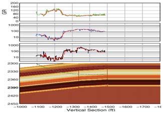
5 Technology Features Real-time analysis and adjustment of stratigraphic sections Curve prediction After many years of theoretical research, the theoretical modeling of GR, AC and LLD has been completed, and the practical application has achieved good results. The geological model is adjusted mainly by predicting curves through theoretical models. GR Borehole Correction Chart Horizontal well GR correction calculation GR Borehole Correction Chart 6 in. 8.5 in. 6 in. 8.5 in. Comparing the measured and predicted curves, adjusting the stratigraphic model, the prediction is consistent with the measured curve, indicating that the stratigraphic model is basically consistent The formation pattern and the apparent dip angle of the formation are determined by GR imaging, and the stratigraphic section and trajectory are adjusted in real time. Interactive picking of the formation dip Due to the uncertainty of the dip angle of the formation, the determination of the dip angle of the formation is the basis for guiding the drilling during the geosteering process. By picking the formation dip module to select points or take segments on the trajectory, the point dip or the average inclination of the well segment can be picked up and displayed and output. Rapid input and calculation of drilling trajectory In order to meet the requirements of on-site work, the DrillDevi Input and TVD Calculation module can be used to quickly input the drilling inclination data and calculate the drilling trajectory.

6 Software Module Basic data loading Establish initial modeling Real-time monitoring AGR / RAD Logging Data Data Access Software Time domain, depth domain Alarm Settings Real-time orientation Module Name Basic Platform Data Collection Real-time display Real-time alarm Single well trajectory calculation Multi-well TVD calculation Vertical formation model Transverse stratigraphic model Generating stratigraphic section Logging curve prediction Target layer real-time alarm AGR/RAD Imaging Pick up the formation dip Boundary distance calculation Manual packaging Automatic packaging Function Description Work area management, well management, data management, system management, etc. Real-time acquisition of Seismic, LWD, Logging Data. Display depth and time domain data in real time, and provide preprocessing tools such as GR calibration and curve splicing. Set alarm parameters to alarm abnormal real-time data. Calculate parameters such as vertical depth, horizontal displacement, east-west displacement, and north-south displacement of the main horizontal well. The TVD batch calculation is performed on the depth domain log data, the stratified data, the interpretation conclusion, the lithology profile, etc., and the data of the TVD domain or the TSD domain is formed. A vertical stratigraphic model is established based on a lithology curve of the target well or adjacent well target segment. The formation interface morphology of the target layer (or a nearby layer) is established based on the structural dip angle, structural map, multi-well contrast or seismic slice data. Combining the vertical and lateral stratigraphic models, a stratigraphic profile is generated to form an initial stratigraphic model. According to the wellbore or adjacent well logging curve, the GR, DT and LLD prediction curves of the horizontal well along the design trajectory and the real drilling trajectory are calculated inversion. The relative positional relationship of the drilling trajectory in the formation model is monitored in real time, and the situation of the top and bottom interface of the formation and the entry and exit of the drill bit into the target layer are warned in advance. The AGR/RAD Imaging can be generated based on the up and down GR and Density for judging the entry and exit layers. Interactively select points on the target layer interface of the formation model and display the apparent dip angle of the formation. Given a certain stratum boundary, calculate the parameters of the track point corresponding to TVD, MD, top margin, and bottom margin. The button triggers a package upload. The package is automatically packaged and uploaded after the completion of the phase.

7 Bottom Hole Assembly (BHA) InteLWD ComLWD CCN RAD MWD CCN RAD MRI AWD AWD EPR BCP-O LWD-O Pressure Gamma Ray Resistivity Directional Sensor Vibration PWD AGR RSU Downhole Motor NGR

8 Rotational Azimuth Density (RAD) Applications Accurate, real-time quantification of porosity and gas identification for saturation calculations Reservoir Navigation using high-resolution imaging and gas oil/water identification in real-time Wellbore stability analysis using azimuthal caliper and density imaging in real-time Structural formation dip analysis and updating reservoir models from density imaging Introduction The CCN and RAD offers measurement of formation density, neutron porosity, borehole caliper, and formation imaging. You can geosteer the well for maximum reservoir ervoir exposure. Neutron porosity and bulk density are critical for the quantification of hydrocarbons in the reservoir. Specifications Service Formation Bulk Density Service with Hole Caliper Tool Type Rotational Azimuth Density Diameter 6.75 in in. Weight 1092 lbs. (495 in lbs. (498 in. (CCN and RAD 4) Maximum Temperature 300 o F (150 o C) Maximum Pressure psi (137.9 MPa) Maximum Dogleg Severity 6.75 in.: 9 /100 ft. Rotating-16 /100 ft. (Sliding) 4.75 in.: 4 blade-10o/100 ft Rotating-25o/100 ft 3 blade-15o/100 ft Rotating-30o/ ft Equivalent Stiffness 6.75 in.: 7.01 in. x 1.87 in in.: 4.82 in.x 1.87 in. Detectors NaI Scintillation Crystal with photomultiplier tube for both Long and Short Spaced detectors Density Specifications Range g/cc Accuracy ±0.015 g/cc Statistical Repeatability ±0.025 g/cc@200 ft/hr (60 m/hr) and 2.5 g/cc Vertical Resolution 18 in. (45 cm) (full resolution) Downhole End Measure Point 5.1 ft (1.5 m) Photoelectric Factor Specifications Range Barnes/electron (B/e) Accuracy ±0.25 B/e from 2-5 B/e Statistical Repeatability ±0.25 B/e@200 ft/hr (60 m/hr) Vertical Resolution 6 in. (150 mm) (full resolution) Downhole End to PeMeasure Point 5.1 ft (1.5 m) Acoustic Standoff Caliper Specifications Range 0-2 in. Accuracy ±0.075 up to 0.5 ±0.125 up to 1.0 ±0. 25 up to 2.0 Maximum Logging Speed 180 ft/hr (@2 points/ft) Radioactive Source Cs137 Strength:2 Curies (74 GBq) Voltage 30 V Current Draw 350 ma~390 ma


 Sensor Type X-Y")
9 Azimuth Gamma Ray (AGR) Applications Geo confirmation of sedimentary structure Confirmation of bed boundaries and orientation Introduction The wellbore cross-section is divided into 8 sectors. The GR is allocated in these sectors.determine the shale content in the sandstone and mudstone Specifications Gamma Specification Maximum Temperature Type Measurement Range Accuracy Vertical Resolution 150 C/175 C (option) Scintillation API GR API ±3% API of full scale 6 in. (153 mm) Inclination Specification Maximum Temperature: 150 C/175 C (option) Sensor Type X-Y axis accelerometer Z axis accelerometer Range degrees Accuracy ±0.1
10 Common Coiled Tubing Drilling (ComCTD) 2-1/2 in. Wireline ComCTD Quick Connnect Sub (UQC and LQC) Pressure Control Sub (PCS) (Optional) Mechnical Circulating and Disconnect Sub (MCD) Mechnical Orienting Sub (MOS) Power and Communication Tool (PCT) Drilling Performance Tool (DPT) (Optional) Vibration& Shock Digital Attitude Sensor (VDS-2) Electromagnetic Propagation Resistivity Tool (EPR-2) Inclination and Gamma Ray (IGR) Gyroscope Orientation Tool-Drilling (GOT-D) (Optional) Electrical Orienting Tool (EOT) Float Value Sub (FVS) 2-3/8 / 2-7/8 Motor PCS DPT GOT-D 2-3/8 Motor FVS EOT IGR EPR-2 VDS-2 PCT MOS MCD UQC / LQC 3-1/8 in. Wireline ComCTD Quick Connnect Sub (UQC and LQC) Pressure Control Sub (PCS) (Optional) Mechnical Circulating and Disconnect Sub (MCD) Mechnical Orienting Sub (MOS) Power and Communication Tool (PCT) Drilling Performance Tool (DPT) (Optional) Vibration& Shock Digital Attitude Sensor (VDS-3) Electromagnetic Propagation Resistivity Tool (EPR-3) Inclination and Gamma Ray (IGR) Gyroscope Orientation Tool-Drilling (GOT-D) (Optional) Electrical Orienting Tool (EOT) Float Value Sub (FVS) 2-7/8 / 3-1/8 Motor PCS DPT GOT-D 2-7/8 Motor FVS EOT IGR EPR-3 VDS-3 PCT MOS MCD UQC / LQC 3-1/8 in. Mud Pluse ComCTD Quick Connnect Sub (UQC and LQC) Pressure Control Sub (PCS) (Optional) Mechnical Circulating and Disconnect Sub (MCD) Mechnical Orienting Sub (MOS) Main Valve Assembly (MVA) Wireless Measurement While Drilling-3 (MWD-3) Electromagnetic Propagation Resistivity Tool (EPR-3) Inclination and Gamma Ray (IGR) Drilling Performance Tool (DPT) (Optional) Float Value Sub (FVS) 2-7/8 / 3-1/8 Motor PCS DPT 2-7/8 Motor FVS IGR EPR-3 MWD-3 MVA MOS MCD UQC / LQC
11 friendly cooperation Chief Operating Officer Wan Hui Mobile:(+86) Tel :(+86) China Sales Supervisor Ding Litao Mobile:(+86) com China China Sales Manager Ding Litao Mobile:(+86) Add: No. 1Hua Chang Road, Science & Technology Park, Changping District, Beijing Tel: (+86) Zip: Middle East Middle East Area Manager Wang Yuwen Mobile:(+86) Russia Russian Operation Manager Guo Feng Mobile:(+86) (+7) com International Sales Manager Sharry Liu Mobile:(+86) Middle East Operation Manager Zhen Shunli Mobile:(+86) Add: No. 64, Novaya Street, Karmaskaly Town, Karmaskaly, Republic of Bashkortostan Tel: (+7) Zip: South America South America Technical Manager Gao Lijun Mobile:(+86) (+58) Marketing Manager Zhang Xujie Mobile:(+86) Russian Technical Manager Chen Hua Mobile:(+86) (+7) com Product Manager Zhang Hong`ai Mobile:(+86) International Sales Director Chen Gang Mobile:(+86) com Add: University Avenue, between Traposos and Chorro streets, Centro Empresarial Building, tenth floor, Office number 10-C, Caracas. Tel: (+58)
MicroScope. Resistivity- and imagingwhile-drilling
 MicroScope Resistivity- and imagingwhile-drilling service MicroScope Magnify your reservoir Multidepth laterolog resistivity Multidepth borehole images Mud resistivity Azimuthal gamma ray Bit resistivity
Heterogeneity Type Porosity. Connected Conductive Spot. Fracture Connected. Conductive Spot. Isolated Conductive Spot. Matrix.
 Porosity Histogram Porosity Contribution 1.3.3.3 Connected 9.8 ohm.m U R D 9 18 7. 5.25 4.38 3.5 2.63 1.75 48 Heterogeneity Distribution Image Orientation, L U 27 36.4.3 X,X72.5 Depth, ft.3 1 Isolated.3
Directional Drilling. History
 Directional Drilling Directional drilling is the science of deviating a well bore along a planned course to a subsurface target whose location is a given lateral distance and direction from the vertical.
X,800. X,850 ft. X,900 ft. X,950 ft. X,000 ft. GeoSphere. Reservoir Mapping-While-Drilling Service
 X,800 X,850 ft X,900 ft X,950 ft X,000 ft GeoSphere Reservoir Mapping-While-Drilling Service Discover reservoir mapping-while-drilling...... and reveal subsurface beddings and fluid contacts at the reservoir
Downhole Navigation for Oil & Gas Drilling
 Downhole Navigation for Oil & Gas Drilling Martin E. Poitzsch Research Director, Sensor Physics Schlumberger-Doll Research, Cambridge, MA A Division of Schlumberger Ltd. Outline Importance of Accurate
Characterizing, Simulating, and Eliminating Vibration Induced Counts in Measurement While Drilling Gamma Ray Detectors. authors
 Abstract: Characterizing, Simulating, and Eliminating Vibration Induced Counts in Measurement While Drilling Gamma Ray Detectors authors K. Kimmich and C. Grodsinsky 1 A Measurement While Drilling (MWD)
Fundamentals Of Petroleum Engineering FORMATION EVALUATION
 Fundamentals Of Petroleum Engineering FORMATION EVALUATION Mohd Fauzi Hamid Wan Rosli Wan Sulaiman Department of Petroleum Engineering Faculty of Petroleum & Renewable Engineering Universiti Technologi
geovision Resistivity imaging for productive drilling
 geovision Resistivity imaging for productive drilling geovision Resistivity imaging while drilling helps position wells in the best place in the reservoir in less time. Real-time resistivity measurements
DEVEX Moving in the Right Direction; Realising Upside Potential in a Mature Field Using Real Time 3D Geo-Steering Technology
 DEVEX 2010 Moving in the Right Direction; Realising Upside Potential in a Mature Field Using Real Time 3D Geo-Steering Technology Authors: Lisa Chisholm, Chevron Upstream Europe David Holbrough, Baker
Predicting the path ahead
 Predicting the path ahead Horizontal drilling has become a routine procedure in many parts of the world and is particularly popular in the Middle East. Despite increasing familiarity with the techniques,
Introduction to Formation Evaluation Abiodun Matthew Amao
 Introduction to Formation Evaluation By Abiodun Matthew Amao Monday, September 09, 2013 Well Logging PGE 492 1 Lecture Outline What is formation evaluation? Why do we evaluate formation? What do we evaluate?
ACCURATE HORIZONTAL WELL PLACEMENT THROUGH EVALUATION OF MULTIPLE LWD IMAGES WITH GEOLOGICAL MODELING.
 ACCURATE HORIZONTAL WELL PLACEMENT THROUGH EVALUATION OF MULTIPLE LWD IMAGES WITH GEOLOGICAL MODELING. Mark Bacciarelli, Giorgio Nardi; Baker Hughes INTEQ, A. A. Al-Hajari, and S. Ma, Saudi Aramco Copyright
New downhole technologies helped develop horizontal thin sand
 Reprinted from: June 2005 issue, pgs 25-33. Used with permission. DRILLING AND COMPLETION TECHNOLOGY SPECIAL FOCUS New downhole technologies helped develop horizontal thin sand Completion of Well Ewan-YH
N121: Modern Petrophysical Well Log Interpretation
 Summary This course presents the principles and methods associated with the petrophysical interpretation of openand cased-hole wireline and LWD well logs. Open-hole topics covered include the use of log
The Deployment of an Azimuthal Resistivity Tool for Geosteering - A Case Study from the Foinaven Field (North Sea)*
*") The Deployment of an Azimuthal Resistivity Tool for Geosteering - A Case Study from the Foinaven Field (North Sea)* Martin Bedrock 1 and Darren Moody 1 Search and Discovery Article #40540 (2010) Posted
The Deployment of an Azimuthal Resistivity Tool for Geosteering - A Case Study from the Foinaven Field (North Sea)* Martin Bedrock 1 and Darren Moody 1 Search and Discovery Article #40540 (2010) Posted
Beijing Geo-Vista Technology Ltd. Serving Oil & Gas Industry
 Beijing Geo-Vista Technology Ltd. Serving Oil & Gas Industry www.renhesun.com www.geovista.cn Introduction Providing Wireline Logging & LWD Services Providing Logging Analysis & Software Development Manufacturing
Drillworks. DecisionSpace Geomechanics DATA SHEET
 DATA SHEET Drillworks overview DecisionSpace Geomechanics Key features Pre-drill, real-time, and post-drill analyses are all easily performed in one application using the latest data from across the field
Exploring for oil with nuclear physics
 Exploring for oil with nuclear physics Marie-Laure Mauborgne 1,a, Françoise Allioli 1, Chris Stoller 2, Mike Evans 2, Mauro Manclossi 1, and Luisa Nicoletti 1 1 Schlumberger Riboud Product Center, Clamart,
Reservoir Rock Properties COPYRIGHT. Sources and Seals Porosity and Permeability. This section will cover the following learning objectives:
 Learning Objectives Reservoir Rock Properties Core Sources and Seals Porosity and Permeability This section will cover the following learning objectives: Explain why petroleum fluids are found in underground
Petrophysical Data and Open Hole Logging Operations Basics COPYRIGHT. Introduction to Petrophysical Data and Open Hole Logging Operations Basics
 Learning Objectives Petrophysical Data and Open Hole Logging Operations Basics Introduction to Petrophysical Data and Open Hole Logging Operations Basics By the end of this lesson, you will be able to:
True 3D measurements for enhanced reservoir quantification. Rt Scanner
 True 3D measurements for enhanced reservoir quantification Rt Scanner Rt Scanner measurements in three dimensions at multiple depths of investigation (DOIs) quantify even low-resistivity laminated pay
Neutron Log. Introduction
 Neutron Log Introduction This summary focuses on the basic interactions between the tool s signal and measured information, that help characterize the formation. It is not intended to be a comprehensive
ECS Elemental Capture Spectroscopy Sonde. Fast, accurate lithology evaluation
 ECS Elemental Capture Spectroscopy Sonde Fast, accurate lithology evaluation Applications n Identify carbonate, gypsum, and anhydrite; quartz, feldspar, and mica; pyrite, siderite, coal, and salt fractions
Sperry Drilling New LWD Technology. Mike Dautel Petrophysics Manager Asia Pacific
 Sperry Drilling New LWD Technology Mike Dautel Petrophysics Manager Asia Pacific Complete LWD Formation Evaluation Azimuthal Gamma Ray Directional Sensors Multi-Depth Resistivity Imaging Azimuthal Density
Basics of Geophysical Well Logs_Porosity
 1 Porosity Logs Porosity (F), can be defined as the ratio between the volume of the pores and the total rock volume. Porosity defines the formation fluid storage capabilities of the reservoir. Well logs
Oil and Natural Gas Corporation Limited, 4th Floor GEOPIC, Dehradun , Uttarakhand
 Sedimentoical Core Samples A Case Study of Western Offshore Basin, India Ashok Soni*, Pradeep Kumar and B.S. Bisht Oil and Natural Gas Corporation Limited, 4th Floor GEOPIC, Dehradun-248195, Uttarakhand
INTRODUCTION TO LOGGING TOOLS
 BY: MUHAMMAD ZAHID INTRODUCTION TO LOGGING TOOLS 1- SPONTANEOUS POTENTIAL (SP) The Spontaneous potential survey, (sp) was one of the first measurements, which was carried out, in a well bore. The SP log
Advances in Geosteering
 Advances in Geosteering SMART4D While Drilling Geosteering Marcellus Case Study Joint Presentation: Feb 27 th 2014, Houston, TX Rocky Mottahedeh, P.Geol. P.Eng. EOW Report University_31_18_2H Advances
Cracking the carbonate code
 Cracking the carbonate code Carbonate reservoirs are the most complex reservoirs in existence, and the Middle East is the place to find them. The complexity and unpredictability of carbonates has frequently
Pore Pressure Prediction and Distribution in Arthit Field, North Malay Basin, Gulf of Thailand
 Pore Pressure Prediction and Distribution in Arthit Field, North Malay Basin, Gulf of Thailand Nutthaphon Ketklao Petroleum Geoscience Program, Department of Geology, Faculty of Science, Chulalongkorn
Shale Gas; Wellbore Positioning Challenges
 Shale Gas; Wellbore Positioning Challenges Pete Clark, Directional Drilling Advisor ISCWSA, Copenhagen, 3/4/11 Shale Gas; Wellbore Positioning Challenges Why is it important to us? Emerging trend in drilling
Well Logging. Salam Al Rbeawi 2011
 Well Logging Salam Al Rbeawi 2011 Well Logging: Is a technique used for formation evaluation to determine the size of the reservoir and the amount of oil and gas in place. The following parameters can
FORMATION EVALUATION PETE 321
 FORMATION EVALUATION PETE 321 DENSITY AND NEUTRON LOGS Summer 2010 David Schechter Fluorescent Intervals in 1U Sand Sharp transition between oil saturated pay and non-pay observed by fluorescence in core
Formation Evaluation: Logs and cores
 These powerpoint files were produced for the Earth History class at the Free University Berlin, Department of Geological Sciences The copyright for texts, graphical elements, and images lies with C. Heubeck,
Course Title: Discipline: Reservoir Level: Intermediate Duration: 5 Days Instructor: JAMES J. SMOLEN, Ph.D. About the course: Audience: Agenda:
 Course Title: Cased Hole and Production Log Evaluation Discipline: Reservoir Level: Intermediate Duration: 5 Days Instructor: JAMES J. SMOLEN, Ph.D. About the course: This 5-day program is a comprehensive
BOXA-II ON-STREAM X-RAY FLUORESCENCE ANALYZER. Technical Description Version 2 BGRIMM AUTOMATION
 BOXA-II ON-STREAM X-RAY FLUORESCENCE ANALYZER Technical Description Version 2 BGRIMM AUTOMATION, South 4th Ring Road West, Beijing, China TEL: +86(10)59069762 Fax: +86(10)68360101 Contents BGRIMM AUTOMATION
Passive or Spontaneous Logs (SP, GR, SPECTRA GR, CALIPER)
") Passive or Spontaneous Logs (SP, GR, SPECTRA GR, CALIPER) By Abiodun Matthew Amao Sunday, March 09, 2014 Well Logging PGE 492 1 Lecture Outline Introduction Spontaneous Potential (SP) Log Tool Physics
Passive or Spontaneous Logs (SP, GR, SPECTRA GR, CALIPER) By Abiodun Matthew Amao Sunday, March 09, 2014 Well Logging PGE 492 1 Lecture Outline Introduction Spontaneous Potential (SP) Log Tool Physics
SPWLA-INDIA 3rd Annual Logging Symposium, Mumbai, India Nov 25-26, 2011
 GEOSTEERING TECHNOLOGY SHOWS THE NEW DIRECTION FOR MAJOR PRODUCTION ENHANCEMENT IN WESTERN ONSHORE, INDIA: AN EXCEPTIONAL SUCCESS-STORY FROM ONGC AHMEDABAD ASSET Arvind Vilasrao Sapkal*, Chandan Jyoti
GEOSTEERING Scope of work, project management and geosteering scenarios
 GEOSTEERING Scope of work, project management and geosteering scenarios Chinook Consulting Services Office: 403 242 1522 742 Memorial Drive NW Calgary, Alberta T2N 3C7 reports@chinookconsulting.ca www.chinookconsulting.ca
Imaging complex structure with crosswell seismic in Jianghan oil field
 INTERPRETER S CORNER Coordinated by Rebecca B. Latimer Imaging complex structure with crosswell seismic in Jianghan oil field QICHENG DONG and BRUCE MARION, Z-Seis, Houston, Texas, U.S. JEFF MEYER, Fusion
1st SPWLA India Regional Conference Formation Evaluation in Horizontal Wells
 GOING BEYOND GEOMETRICAL DRILLING : A REVIEW OF THE CONTRIBUTION OF LWD MEASUREMENTS TO THE IMPROVEMENT OF WELL PLACEMENT. Jacques R. Tabanou, Jean Michel Denichou, Jack Horkowitz, Dzevat Omeragic, John
Ingrain Laboratories INTEGRATED ROCK ANALYSIS FOR THE OIL AND GAS INDUSTRY
 Ingrain Laboratories INTEGRATED ROCK ANALYSIS FOR THE OIL AND GAS INDUSTRY 3 INGRAIN We Help Identify and Develop the Most Productive Reservoir by Characterizing Rocks at Pore Level and Upscaling to the
Applications of Borehole Imaging to Hydrocarbon Exploration and Production
 Applications of Borehole Imaging to Hydrocarbon Exploration and Production Instructor: Philippe MONTAGGION / NExT, Schlumberger Title: Petroleum Geology Consultant Specialty: Borehole Imaging, Petroleum
INTRODUCTION TO WELL LOGS And BAYES THEOREM
 INTRODUCTION TO WELL LOGS And BAYES THEOREM EECS 833, 7 February 006 Geoff Bohling Assistant Scientist Kansas Geological Survey geoff@kgs.ku.edu 864-093 Overheads and resources available at http://people.ku.edu/~gbohling/eecs833
Well Logging Importance in Oil and Gas Exploration and Production
 Well Logging Importance in Oil and Gas Exploration and Production Dr. R. Giri Prasad 1 1 Associate Professor, Dept. of Petroleum Engineering, Aditya Engineering College, hod_pt@aec.edu.in I. INTRODUCTION
Synthetic Seismogram A Tool to Calibrate PP & PS Seismic Data
 P-475 Summary Synthetic Seismogram A Tool to Calibrate PP & PS Seismic P. Sugadha*, M. K. Jain, M. Singh, ONGC Conventional P wave technology will not meet all the requirements of the industry. Hence,
An Integrated Petrophysical Approach for Shale Gas Reservoirs
 An Integrated Petrophysical Approach for Shale Gas Reservoirs Richard Arnold & Matt Bratovich Baker Hughes Reservoir Development Services 1 2014 B A K E R H U G H E S I N C O R P O R A TED. A LL R I G
11th Biennial International Conference & Exposition
 Analysis of Cleats in Coal Bed Methane wells from Micro Resistivity Image and Cross Dipole Array Acoustic Log Muhammad Ali* (ONGC), Partho Sarathi Sen (ONGC) Email ID: muhammadali_nzr@yahoo.co.in Keywords
SELECTED PAPERS AND PUBLICATIONS
 SELECTED PAPERS AND PUBLICATIONS SPE 153580: Milestone in Production Using Proactive Azimuthal Deep- Resistivity Sensor Combined with Advanced Geosteering Techniques: Tarapoa Block, Ecuador. Alex Guevara,
Improved Petrophysical Analysis in Horizontal Wells: From Log Modeling Through Formation Evaluation to Reducing Model Uncertainty A Case Study
 SPE 164881 Improved Petrophysical Analysis in Horizontal Wells: From Log Modeling Through Formation Evaluation to Reducing Model Uncertainty A Case Study A. Valdisturlo, M. Mele, Eni e&p. D. Maggs SPE,
GEOSTEERING SERVICES. Geosteering Technologies develops the software for geosteering in real-time and provides technical support in this areas.
 Компания «Геонавигационные Технологии» занимается производством программного обеспечения для сопровождения наклоннонаправленного бурения скважин, а также оказывает консультационные услуги в данной области.
Corporate Houston, TX... (713)
") Allied Wireline Services and Horizontal Wireline Services are proud to announce that we are now one company, dedicated to providing you the highest value wireline services and built on the commitment to
Allied Wireline Services and Horizontal Wireline Services are proud to announce that we are now one company, dedicated to providing you the highest value wireline services and built on the commitment to
Introduction to Oil&Gas Well Drilling
 Introduction to Oil&Gas Well Drilling Drilling Introduction to Oil&Gas Well Drilling The term drilling indicates the whole complex of operations necessary to construct wells of circular section applying
MUDLOGGING, CORING AND CASED HOLE LOGGING BASICS COPYRIGHT. Cased Hole Logging. By the end of this lesson, you will be able to:
 LEARNING OBJECTIVES MUDLOGGING, CORING AND CASED HOLE LOGGING BASICS Cased Hole Logging By the end of this lesson, you will be able to: Identify common Cased Hole Logs and understand why the data are needed
Cornish Institute of Engineers Conference th October 2013
 Wellbore Stability and Real Time Drilling Optimisation: Delivered Worldwide from Cornwall Sarah Marks Cornish Institute of Engineers Conference 2013 11 th October 2013 GeoScience Limited, Falmouth Business
ARES ENERGY, LTD. SDI Survey Report. Fuhrman-Mascho Andrews County, Texas (Grid North) University 13 #2H VH - Job # KW-204.
 University 13 #2H VH - Job # KW-204.") ARES ENERGY, LTD. Fuhrman-Mascho Andrews County, Texas (Grid North) University 13 #2H VH - Job #320214-KW-204 Survey: Gyro SDI Survey Report 17 February, 2014 SDI SDI Survey Report Company: ARES ENERGY,
ARES ENERGY, LTD. Fuhrman-Mascho Andrews County, Texas (Grid North) University 13 #2H VH - Job #320214-KW-204 Survey: Gyro SDI Survey Report 17 February, 2014 SDI SDI Survey Report Company: ARES ENERGY,
Design of Safety Monitoring and Early Warning System for Buried Pipeline Crossing Fault
 5th International Conference on Civil Engineering and Transportation (ICCET 2015) Design of Safety Monitoring and Early Warning System for Buried Pipeline Crossing Fault Wu Liu1,a, Wanggang Hou1,b *, Wentao
Evaluating Horizontal Cased Wells for Completion Design
 Evaluating Horizontal Cased Wells for Completion Design Dallas SPE 4/20/2016 Rick Reischman Schlumberger Houston Unconventional Domain Evaluating Horizontal Cased Wells for Completion Design Introduction
QUANTITATIVE STUDIES OF RELATIVE DIP ANGLE AND BED - THICKNESS EFFECTS ON LWD DENSITY IMAGES ACQUIRED IN HIGH-ANGLE AND HORIZONTAL WELLS
 QUANTITATIVE STUDIES OF RELATIVE DIP ANGLE AND BED - THICKNE EFFECTS ON LWD DENSITY IMAGES ACQUIRED IN HIGH-ANGLE AND HORIZONTAL WEL E.A. Uzoh, A. Mendoza, and C. Torres-Verdín, The University of Texas
J.V. Herwanger* (Ikon Science), A. Bottrill (Ikon Science) & P. Popov (Ikon Science)
, A. Bottrill (Ikon Science) & P. Popov (Ikon Science)") 29829. One 4D geomechanical model and its many applications J.V. Herwanger* (Ikon Science), A. Bottrill (Ikon Science) & P. Popov (Ikon Science) Main objectives (i) Field case study demonstrating application
29829. One 4D geomechanical model and its many applications J.V. Herwanger* (Ikon Science), A. Bottrill (Ikon Science) & P. Popov (Ikon Science) Main objectives (i) Field case study demonstrating application
Application of Pressure Data Analysis in Tapping the Potential of Complex Fault Block Oilfield
 Advances in Petroleum Exploration and Development Vol. 12, No. 2, 2016, pp. 44-50 DOI:10.3968/9118 ISSN 1925-542X [Print] ISSN 1925-5438 [Online] www.cscanada.net www.cscanada.org Application of Pressure
Advances in Elemental Spectroscopy Logging: A Cased Hole Application Offshore West Africa
 Journal of Geography and Geology; Vol. 9, No. 4; 2017 ISSN 1916-9779 E-ISSN 1916-9787 Published by Canadian Center of Science and Education Advances in Elemental Spectroscopy Logging: A Cased Hole Application
1 of :32
 Home Page Products Price List Links & PDFs DISCONTINUED: SEE GAMMA-RAD Gamma Ray & X-Ray Spectroscopy System Hand-Held, High Efficiency NaI(Tl) Detector The GAMMA-8000 is a powerful, portable instrument
Forge Energy. Andrews County, TX. Slot: No. 4426H Facility: Well: Andrews County, TX (NAD 83 / Grid) Wellbore: (UL 13 Dover) Sec 26, Blk 13, USLS
 Wellbore: (UL 13 Dover) Sec 26, Blk 13, USLS") Location: Forge Energy Andrews County, TX Slot: H&P 461 Field: Andrews County, TX (NAD 83 / Grid) Well: No. 4426H Facility: (UL 13 Dover) Sec 26, Blk 13, USLS Wellbore: Plot reference wellpath is True
Location: Forge Energy Andrews County, TX Slot: H&P 461 Field: Andrews County, TX (NAD 83 / Grid) Well: No. 4426H Facility: (UL 13 Dover) Sec 26, Blk 13, USLS Wellbore: Plot reference wellpath is True
The SPE Foundation through member donations and a contribution from Offshore Europe
 Primary funding is provided by The SPE Foundation through member donations and a contribution from Offshore Europe The Society is grateful to those companies that allow their professionals to serve as
Einsatzmöglichkeiten von Universal Bohranlagen im russischen Mining Sektor Applications of Multi purpose drilling rigs in the Russian Mining sector
 Einsatzmöglichkeiten von Universal Bohranlagen im russischen Mining Sektor Applications of Multi purpose drilling rigs in the Russian Mining sector Dr. Dierk Wagenschein PRAKLA Bohrtechnik GmbH 1 The Construction
Wellsite Consulting Services Diversified Well Logging LLC. All Rights Reserved.
 Wellsite Consulting Services We are CUSTOMER FOCUSED: We seek to exceed customer expectations by providing solutions that improve their drilling, completions, and production economics OUR CORE VALUES DEFINE
4. GIS Implementation of the TxDOT Hydrology Extensions
 4. GIS Implementation of the TxDOT Hydrology Extensions A Geographic Information System (GIS) is a computer-assisted system for the capture, storage, retrieval, analysis and display of spatial data. It
Produce arrays of semi-permanent deep access holes for a variety of investigations (climatological, geological, glaciological, biological)
") CTDI Coiled Tubing Drill for Ice An Exploration Tool for Polar Sciences The CTDI drilling system uses a high-pressure pump and coiled tubing to deliver fluid to a steerable downhole hydraulic motor that
CTDI Coiled Tubing Drill for Ice An Exploration Tool for Polar Sciences The CTDI drilling system uses a high-pressure pump and coiled tubing to deliver fluid to a steerable downhole hydraulic motor that
M.M.Panigrahi*, S.R.Meena, Rudal Singh, B.C.Sethy, R.D.Chourasiya, S.K.Verma. ONGC Ltd., India; Pallav Chakraborty, Schlumberger, India Geomarket.
 P - 35 Improved Hydrocarbon Recovery from Carbonate Reservoir of Mumbai High North Field by Geological Steering Based on Real Time LWD (Logging While Drilling) Data- A Case Study. M.M.Panigrahi*, S.R.Meena,
Well Evaluation. An Integrated Well-Evaluation Process for Shale Gas Reservoirs
 Well Evaluation An Integrated Well-Evaluation Process for Shale Gas Reservoirs APPLICATION Gas shale analysis for unconventional wells BENEFITS Optimized stimulation by thorough study and planning Increased
Open Access Study on Reservoir-caprock Assemblage by Dual Logging Parameter Method
 Send Orders for Reprints to reprints@benthamscience.ae 282 The Open Petroleum Engineering Journal, 2015, 8, (Suppl 1: M4) 282-287 Open Access Study on Reservoir-caprock Assemblage by Dual Logging Parameter
FATEK. FBs-1HLC. Precision Load Cell Module. Operation manual V1.1 06/07/2017 FATEK AUTOMATION CORP.
 FATEK FBs-1HLC Precision Load Cell Module Operation manual V1.1 06/07/2017 FATEK AUTOMATION CORP. 1 Contents Chapter 1 1HLC module introduction... 3 1.1 Module specification... 3 1.2 Module appearance
Characterization of Fractures from Borehole Images. Sandeep Mukherjee- Halliburton
 Characterization of Fractures from Borehole Images Sandeep Mukherjee- Halliburton Summary Characterization of fractures is an important aspect of formation evaluation. Fractures, when present could alter
The SPE Foundation through member donations and a contribution from Offshore Europe
 Primary funding is provided by The SPE Foundation through member donations and a contribution from Offshore Europe The Society is grateful to those companies that allow their professionals to serve as
The Evolution of Drilling Techniques at the Camden Gas Project. Chris Holmes and Jon Black AGL 27 th June 2007
 The Evolution of Drilling Techniques at the Camden Gas Project Chris Holmes and Jon Black AGL 27 th June 2007 1 Camden Gas Project Status AGL acquired operatorship from Sydney Gas February 2006 106 production
PETROPHYSICAL EVALUATION CORE COPYRIGHT. Petrophysical Evaluation Approach and Shaly Sands Evaluation. By the end of this lesson, you will be able to:
 PETROPHYSICAL EVALUATION CORE Petrophysical Evaluation Approach and Shaly Sands Evaluation LEARNING OBJECTIVES By the end of this lesson, you will be able to: Discuss how to approach a petrophysical evaluation
SEG Houston 2009 International Exposition and Annual Meeting
 Improving seismic calibration and geomechanical models through characterization of anisotropy using single and multi well data: Case Study in Forties Field, UK Adam Donald*, Andrea Paxton (Schlumberger),
Characteristics of the Triassic Upper Montney Formation (Unit C), West-Central Area, Alberta
, West-Central Area, Alberta") Characteristics of the Triassic Upper Montney Formation (Unit C), West-Central Area, Alberta Omar Derder NeoSeis Technology Group Ltd., Calgary, Alberta omarderder@neoseis.com Abstract Unconventional hydrocarbon
Characteristics of the Triassic Upper Montney Formation (Unit C), West-Central Area, Alberta Omar Derder NeoSeis Technology Group Ltd., Calgary, Alberta omarderder@neoseis.com Abstract Unconventional hydrocarbon
POTASH DRAGON CHILE GEOPHYSICAL SURVEY TRANSIENT ELECTROMAGNETIC (TEM) METHOD. LLAMARA and SOLIDA PROJECTS SALAR DE LLAMARA, IQUIQUE, REGION I, CHILE
 METHOD. LLAMARA and SOLIDA PROJECTS SALAR DE LLAMARA, IQUIQUE, REGION I, CHILE") POTASH DRAGON CHILE GEOPHYSICAL SURVEY TRANSIENT ELECTROMAGNETIC (TEM) METHOD LLAMARA and SOLIDA PROJECTS SALAR DE LLAMARA, IQUIQUE, REGION I, CHILE OCTOBER 2012 CONTENT Page I INTRODUCTION 1 II FIELD
POTASH DRAGON CHILE GEOPHYSICAL SURVEY TRANSIENT ELECTROMAGNETIC (TEM) METHOD LLAMARA and SOLIDA PROJECTS SALAR DE LLAMARA, IQUIQUE, REGION I, CHILE OCTOBER 2012 CONTENT Page I INTRODUCTION 1 II FIELD
Exploration / Appraisal of Shales. Petrophysics Technical Manager Unconventional Resources
 Exploration / Appraisal of Shales Rick Lewis Petrophysics Technical Manager Unconventional Resources Organic Shale Factors Controlling Gas Reservoir Quality Conventional sandstone Mineral framework Gas
Novel Application in Determining Oil Shale Porosity Using a Borehole Gravimeter
 Novel Application in Determining Oil Shale Porosity Using a Borehole Gravimeter Shell Exploration & Production Katia Pronina Robert Pimentel Matt Holman (presenter) 3/17/2010 File Title Copyright: SIPC
Technology. configured through the instructor application.
 dewjournal.com Fig.9 Hardware layout alternative 3 (Drillers cabin mock-up) projectors to view 3D or 2D data visualization of the processes in the well bore. The hardware configuration can be changed to
DEVELOPMENT OF DROP WEIGHT IMPACT TEST MACHINE
 CHAPTER-8 DEVELOPMENT OF DROP WEIGHT IMPACT TEST MACHINE 8.1 Introduction The behavior of materials is different when they are subjected to dynamic loading [9]. The testing of materials under dynamic conditions
Shale Development and Hydraulic Fracturing or Frac ing (Fracking) What is it?
 What is it?") P E T R O L E U M E N G I N E E R I N G D E P A R T M E N T Shale Development and Hydraulic Fracturing or Frac ing (Fracking) What is it? Dr. Will Fleckenstein, PE Colorado School of Mines 1 Who is involved
P E T R O L E U M E N G I N E E R I N G D E P A R T M E N T Shale Development and Hydraulic Fracturing or Frac ing (Fracking) What is it? Dr. Will Fleckenstein, PE Colorado School of Mines 1 Who is involved
Geophysical methods for the study of sedimentary cycles
 DOI 10.1007/s12182-009-0041-9 259 Geophysical methods for the study of sedimentary cycles Xu Jingling 1, 2, Liu Luofu 1, 2, Wang Guiwen 1, 2, Shen Jinsong 1, 2 and Zhang Chunhua 3 1 School of Resources
Elk River Resources, LLC Andrews County, TX Sec 24, Blk 12, University Land Survey Wapiti H Wellbore #1 Survey: MWD Surveys (QES) QES Survey Re
 QES Survey Re") Elk River Resources, LLC Andrews County, TX Sec 24, Blk 12, University Land Survey Wapiti 12-24 1H Wellbore #1 Survey: MWD Surveys (QES) QES Survey Report 08 February, 2017 QES Directional Drilling, LLC
Elk River Resources, LLC Andrews County, TX Sec 24, Blk 12, University Land Survey Wapiti 12-24 1H Wellbore #1 Survey: MWD Surveys (QES) QES Survey Report 08 February, 2017 QES Directional Drilling, LLC
region includes nine states and four provinces, covering over 1.4 million square miles. The PCOR Partnership
 Overview of Phase II PCOR Partnership MVA Activities IEAGHG Monitoring Network Meeting Natchez, MS May 6-8, 2010 Steven A. Smith, Energy & Environmental Research Center The Plains CO 2 Reduction (PCOR)
But these are what we really measure with logs..
 The role of the petrophysicist in reservoir characterization and the analysis of reservoir performance. What do we bring to the table? What do we want to take home? Bob Cluff The Discovery Group Inc. consulting
Copyright 2008, University of Chicago, Department of Physics. Experiment VI. Gamma Ray Spectroscopy
 Experiment VI Gamma Ray Spectroscopy 1. GAMMA RAY INTERACTIONS WITH MATTER In order for gammas to be detected, they must lose energy in the detector. Since gammas are electromagnetic radiation, we must
Mechanical Properties Log Processing and Calibration. R.D. Barree
 Mechanical Properties Log Processing and Calibration R.D. Barree Logging for Mechanical Properties Acoustic logs Measure compressional and shear velocity or slowness (1/v) Can be affected by fractures,
Technology of Production from Shale
 Technology of Production from Shale Doug Bentley, European Unconventional, Schlumberger May 29 th, 2012 Johannesburg, South Africa What are Unconventional Reservoirs Shale both Gas & Oil Coal Bed Methane
GEO4270 EXERCISE 2 PROSPECT EVALUATION
 GEO4270 EXERCISE 2 PROSPECT EVALUATION GEO4270 Integrated Basin Analysis and Prospect Evaluation 1. Integrated Seismic (reflection/refraction), Gravity and Magnetics and Basin Modelling Large Scale Structures
Implementing and Monitoring a Geomechanical Model for Wellbore Stability in an Area of High Geological Complexity
 AADE-10-DF-HO-15 Implementing and Monitoring a Geomechanical Model for Wellbore Stability in an Area of High Geological Complexity J. G. Vargas, Halliburton; J. Mateus, Halliburton; A. Jaramillo, Halliburton;
PYCKO SCIENTIFIC LIMITED
 PYCKO SCIENTIFIC LIMITED 31 London Road, Grantham, NG31 6EX Telephone 01476 401992 bill@pycko.co.uk www.pycko.co.uk Your Alternative To The Obvious RayMon10 TM Detect, measure, identify and analyse radionuclides
Raptor A New High-Technology, High-Value. Dr. Darryl Trcka Senior Research Scientist Raptor Interpretive Product Manager
 Raptor A New High-Technology, High-Value Pulsed Neutron Measurement from Weatherford Dr. Darryl Trcka Senior Research Scientist Raptor Interpretive Product Manager 2012 Weatherford. All rights reserved.
GEOLOGICAL LOG INTERPRETATION TUTORIAL
 GEOLOGICAL LOG INTERPRETATION TUTORIAL Text and Figures by Geoff Bohling and John Doveton The following pages will familiarize you with the basics of the geological interpretation of common logs as they
Abstract. 1. Introduction. Geophysics Engineer-Schlumberger 2. M.Sc. Petroleum-PEMEX 3,4 Geologists-PEMEX
 IBP3018 MINIMIZING DRILLING RISKS FOR EXPLORATION WELL IN DEEP WATER USING SEISMIC WHILE DRILLING TECHNOLOGY Sanchez Adrian 1, Mora Alfonso 2 Aguilera Leonardo 3, Gaitan Rito 4 Copyright 2010, Brazilian
Seismic Guided Drilling: Near Real Time 3D Updating of Subsurface Images and Pore Pressure Model
 IPTC 16575 Seismic Guided Drilling: Near Real Time 3D Updating of Subsurface Images and Pore Pressure Model Chuck Peng, John Dai and Sherman Yang, Schlumberger WesternGeco Copyright 2013, International
Acoustic Anisotropy Measurements and Interpretation in Deviated Wells
 Acoustic Anisotropy Measurements and Interpretation in Deviated Wells X. M. Tang, and D. Patterson, Houston Technology Center, Baker Atlas, Houston, Texas, USA ABSTRACT Many acoustic anisotropy measurements