Are there any sandstone hosted uranium systems in the Eromanga Basin? Simon van der Wielen
|
|
|
- Jennifer Hill
- 5 years ago
- Views:
Transcription

1 Are there any sandstone hosted uranium systems in the Eromanga Basin? Simon van der Wielen Alison Kirkby, Allison Britt, Anthony Schofield, Roger Skirrow, Evgeniy Bastrakov, Andrew Cross, Malcolm Nicoll, Terry Mernagh, Andrew Barnicoat
2 Talk Outline Sandstone hosted uranium system model Locality map Methodology on how the Eromanga 3D map was constructed Eromanga Basin geology Prospectivity Analysis: Euroka Arch region Lake Eyre region Conclusions

 fluid acting as a reductant.")
3 Conceptual Sandstone U System Models Single fluid model Oxidised fluid carrying Uranium. In-situ reductant. Two fluids model Oxidised fluid carrying Uranium. Reduced (hydrocarbons or H 2 S) fluid acting as a reductant. Figures courtesy of Subhash Jaireth
4 Locality Map Study Area NW Corner: -150,000 me; -1,250,000 mn. SE Corner: 1,700,000 me; -3,800,000 mn. Eromanga Basin: 1,224,506 km 2 Surat Basin: 257,460 km 2 Carpentaria Basin: 696,090 km 2
5 AREA REDUCTION: How do we reduce the area from size of western Europe (~2,000,000 km 2 ) to the size of Monaco (~2 km 2 )??? Discovery DRILLING 1 * 1 km Data acquisition, Data processing and interpretation Data Compilation, Regional Datasets Literature Review and National Datasets Structures, Chemical Gradients, Lithological Traps Major Basin Architecture, Large Scale REDOX Gradients and Fluid Flow Pathways Review of Australian Phanerozoic Basins 10 * 10 km 100 * 100 km 1000 * 1000 km Increase Cost
6 The Approach 1. Integrate existing datasets into a 3D environment (this case gocad) 2. Use existing datasets to build a 3D map of the Eromanga Basin 3. Identify what datasets can be used to map the major mineral system ingredients 4. Produce a 3D minerals system assessment for the Eromanga Basin 5. Ground truthing: Conduct detailed geochemical and petrographic studies over areas highlighted to determine whether a uranium mineral system has been active
7 Data Model GA DEM Surface Geology Geophysics Problems: 1. No consistent formats. 2. Data is of variable quality. 3. Data is difficult to find (not readily searchable). Mineral Geological Logs Wire-line Logs Analytical Petroleum Geological Logs Wire-line Logs Analytical Eromanga Common Earth Model State Surveys Stratigraphic Picks Data Compilations BRS Hydrogeochemical Stratigraphic Picks Wire-line Logs
8 Eromanga 3D map Construction - outline DEM Surface Geology Drilling Markers Surface Construction Production of a 3D Geological Block Model (gocad voxet)
9 Stratigraphic Framework 00_DEM (Topography) 01_Ksrw (Winton) 02_Ksrm (Mackunda) 03_Klro (Toolebuc) 04_Ksr (Rolling Downs) 05_Ksco (Cadna-owie) 06_Jsyh (Hooray) 07_Jsbh (Hutton) 08_Rsmo (Moolayember) 09_Rsl (Clematis) 10_Basement Radke et al., 2000
")
 03_Klro (Toolebuc)")
 06_Jsyh (Hooray)")
 09_Rsl (Clematis)")
10 Production of a 3D Geological Block Model (gocad voxet) 01_Ksrw (Winton) 02_Ksrm (Mackunda) 03_Klro (Toolebuc) 04_Ksr (Rolling Downs) 05_Ksco (Cadna-owie) 06_Jsyh (Hooray) 07_Jsbh (Hutton) 08_Rsmo (Moolayember) 09_Rsl (Clematis) Vertical Exaggeration = 50 times
11 Targets Target One Euroka Arch Target Two Lake Eyre Region


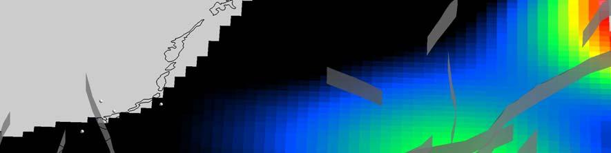


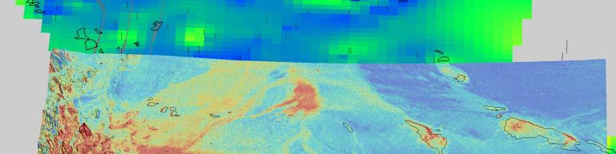

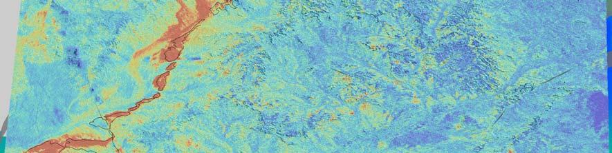


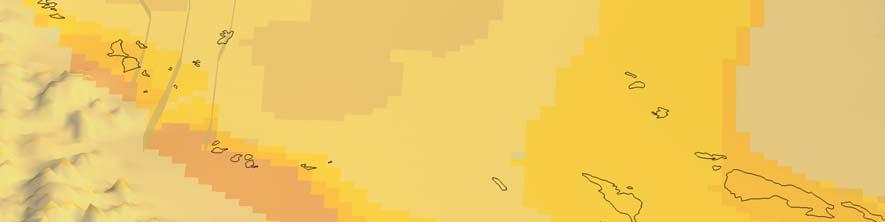


12 N Euroka Arch Mt Isa Inlier 50 km Georgetown Inlier DEM surface Geology Natural Gamma Logs (black) Gridded Data Radiometrics Uranium on DEM Hydrochemistry Points Gridded Uranium Natural Uranium Gamma mg/lapi
13 Targets Target One Euroka Arch Target Two Lake Eyre Region


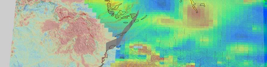
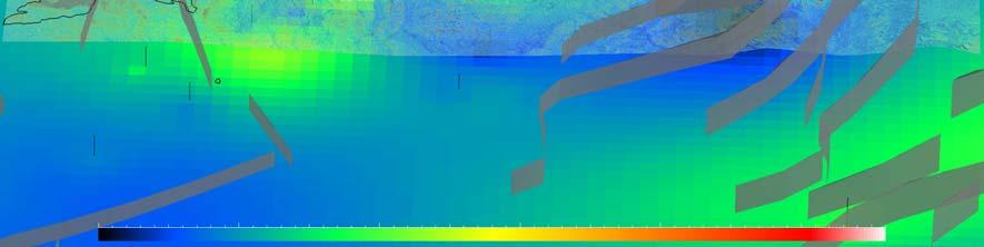
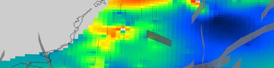
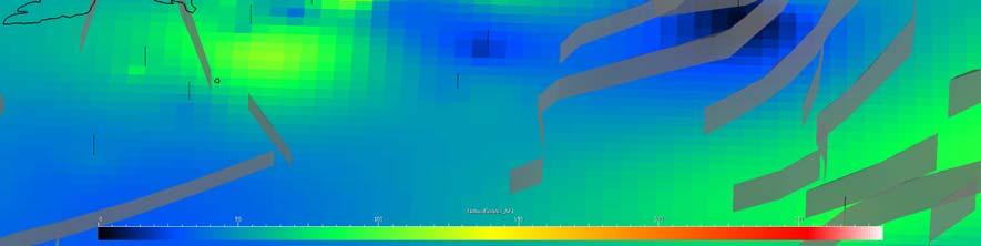
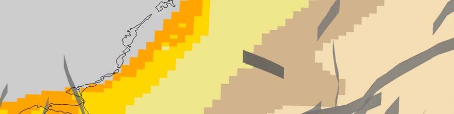
14 Lake Eyre N Lake Eyre DEM Surface Geology Hydrochemistry Points Gridded Eh Gridded Ba Gridded ph Gridded U 50 km Uranium Barium Eh ph (mv) (mg/l)
15 Conclusions Applying Mineral System concepts reduces exploration risk by rapidly decreasing the search area First time disparate datasets for the Eromanga Basin have been integrated and visualised together The Eromanga 3D Map has potential applications to other geoscience research: Geothermal prospectivity Petroleum prospectivity Groundwater studies Carbon Capture and Storage (CCS) studies
Uranium deposit types: a systems perspective
 Uranium deposit types: a systems perspective Roger Skirrow Onshore Energy & Minerals Division roger.skirrow@ga.gov.au Outline 1. A new view of U deposit types: 3 families of mineral systems 2. Concepts
Frome uranium province, South Australia: Systems analysis and potential for major basin-hosted uranium deposits
 Frome uranium province, South Australia: Systems analysis and potential for major basin-hosted uranium deposits Roger Skirrow, E. Bastrakov, A. Cross, S. Jaireth, A. Schofield, S. van der Wielen Frome
Uranium in the Frome Embayment: Recent results from Geoscience Australia s Onshore Energy Security Program
 Uranium in the Frome Embayment: Recent results from Geoscience Australia s Onshore Energy Security Program Simon van der Wielen A. Britt, E. Bastrakov, A. Cross, S. Jaireth, M. Le Gleuher, A. Schofield,
Galilee Basin Mining and Groundwater
 Galilee Basin Mining and Groundwater Impact on the Great Artesian Basin John Hillier Acknowledgements Some diagrams used in this presentation have been obtained from: EIS for proposed mining ventures A
Axiom Announces First Energy Project Eden Vale Sedimentary Uranium
 ASX / Media Release 4 June 2013 Axiom Announces First Energy Project Eden Vale Sedimentary Uranium HIGHLIGHTS An application lodged for exploration of known sedimentary hosted uranium deposit over 330km
Energy potential of the Millungera Basin: a newly discovered basin in North Queensland
 Energy potential of the Millungera Basin: a newly discovered basin in North Queensland Russell Korsch 1, H. Struckmeyer 1, A. Kirkby 1, L Hutton 2, L Carr 1, K. Hoffmann 2, R. Chopping 1, I. Roy 1, M.
Galilee Basin. Galilee Basin Hydrogeological Investigations. Briefing to RAPAD Longreach, 16 May rpsgroup.com.au
 Galilee Basin Galilee Basin Hydrogeological Investigations Briefing to RAPAD Longreach, 16 May 20116 1 The Galilee Basin Geologically & hydrogeological diverse sedimentary Covers 247,000 km 2 The Galilee
Improvements on 2D modelling with 3D spatial data: Tin prospectivity of Khartoum, Queensland, Australia
 Improvements on 2D modelling with 3D spatial data: Tin prospectivity of Khartoum, Queensland, Australia C. E. Payne, F. W. Cunningham, A. J. Wilkins & G. A. Partington Kenex Ltd. Outline Prospectivity
6.0 DERM registered water bores
 6.0 DERM registered water bores 6.1 Introduction RPS reviewed the groundwater data available in the DERM GWDB (2010) and identified over 10,400 registered water bores within the Galilee Basin study area.
3. Radiometry. The Australian Continent: A Geophysical Synthesis Radiometry
 16 3. Radiometry A major effort has been made to assemble a continent-scale study combining the results of many different airborne radiometric surveys (Figure 3.1). The radiometric surveys measure the
Correlations between spectral mineralogy and borehole rock properties in the Eromanga Basin. Ian Roach
 Correlations between spectral mineralogy and borehole rock properties in the Eromanga Basin Ian Roach Introduction The Southern Thomson Project Stratigraphic drilling & logging program Rock properties
For personal use only
 20 7 APRIL JANUARY 2017 2017 ASX ASX ANNOUNCEMENT QUEENSLAND EXPLORATION PROJECTS UPDATE Projects identified by Sasak through analysis of regional geophysics and geochemistry databases to target IOCG (Iron
Mineral Systems modelling in the Mount Isa Inlier, and its use in identification of permissive tracts for copper and lead/zinc mineralisation.
 Department of Natural Resources and Mines Mineral Systems modelling in the Mount Isa Inlier, and its use in identification of permissive tracts for copper and lead/zinc mineralisation. L.J.Hutton Geological
Wire-line Logged Waterbores in the Great Artesian Basin. Digital Data of Logs and Waterbore Data Acquired by AGSO
 Wire-line Logged Waterbores in the Great Artesian Basin Digital Data of Logs and Waterbore Data Acquired by AGSO A report to the National Landcare Program M A Habermehl Commonwealth of Australia 2001 ISBN
The Lake Eyre Basin a Kazakh Analogue?
 The Lake Eyre Basin a Kazakh Analogue? Legal Disclaimer This presentation has been prepared by T C Development Corporation Pty Ltd and Crescent Gold Ltd. The information contained in this presentation
Airborne gravity gradiometer surveying of petroleum systems under Lake Tanganyika, Tanzania
 Airborne gravity gradiometer surveying of petroleum systems under Lake Tanganyika, Tanzania D. Roberts Beach Energy P. Roy Chowdhury CGG S. J. Lowe CGG A. N. Christensen CGG Outline Introduction Geology
NT RESOURCES LIMITED QUARTERLY ACTIVITIES REPORT FOR THE PERIOD ENDED 30 JUNE 2010 ASX CODE: NTR
 NT RESOURCES LIMITED QUARTERLY ACTIVITIES REPORT FOR THE PERIOD ENDED 30 JUNE 2010 ASX CODE: NTR Activities Report Background NT Resources Limited ( NT Resources or the Company ) holds six granted Exploration
The Pine Creek AEM Survey, Northern Territory
 The Pine Creek AEM Survey, Northern Territory (Data acquisition, processing, delivery and interpretation) M.A. Craig, M.T. Costelloe, S. Liu, S. Jaireth Onshore Energy and Minerals Division, Geoscience
ONSHORE ENERGY SECURITY PROGRAM 5 YEAR PLAN
 Onshore Energy Security Progr ONSHORE ENERGY SECURITY PROGRAM 5 YEAR PLAN Summary This document outlines Geoscience Australia s Onshore Energy Security Program and a working plan for its implementation
MINERAL EXPLORATION UNDER DEEP COVER. Neil Williams School of Earth & Environmental Sciences
 MINERAL EXPLORATION UNDER DEEP COVER Neil Williams School of Earth & Environmental Sciences The problem Discovery rates, especially of world-class deposits, have fallen significantly over the past 15-20
Implications of AEM for uranium in the Paterson area
 Implications of AEM for uranium in the Paterson area Songfa Liu, Subhash Jaireth, David Huston, Ian Roach Onshore Energy and Minerals Division, Geoscience Australia GPO Box 378, Canberra ACT 2601 Outline
Uncovering the greater McArthur Basin, Northern Territory Tania Dhu Manager Geophysics and Remote Sensing, Northern Territory Geological Survey
 Uncovering the greater McArthur Basin, Northern Territory Tania Dhu Manager Geophysics and Remote Sensing, Northern Territory Geological Survey www.minerals.nt.gov.au Why focus on the McArthur Basin? Large,
Williston Basin Architecture and Hydrocarbon Potential: A Targeted Geoscience Initiative Project 1
 Williston Basin Architecture and Hydrocarbon Potential: A Targeted Geoscience Initiative Project 1 S.G. Whittaker Whittaker, S.G. (2005): Williston Basin architecture and hydrocarbon potential: A Targeted
GSWA Lower Lesueur 2D Seismic Survey. A summary on the impact of the new seismic survey on the South West Hub Carbon Capture and Storage Project
 GSWA Lower Lesueur 2D Seismic Survey A summary on the impact of the new seismic survey on the South West Hub Carbon Capture and Storage Project Cautionary Statement Advice and opinions given by Schlumberger
Assessing our untapped energy resources. Derek Reay Geological Survey of Northern Ireland
 Assessing our untapped energy resources Derek Reay Geological Survey of Northern Ireland Talk Outline Northern Ireland energy market Oil and Gas Exploration Description Exploration risks Application of
EXPLORATION SUCCESS AT COYOTE GOLD MINE
 19 November 2012 Jon Latto COMPANY SECRETARY Jane Bown EXECUTIVE ASSISTANT EXPLORATION SUCCESS AT COYOTE GOLD MINE COYOTE GOLD MINE HIGHLIGHTS Ongoing exploration drilling continues to return high grade
NWQ Geochemistry Toolkit
 NWQ Geochemistry Toolkit Meeting the challenge of finding buried and blind ore deposits QEC Technical Forum 2018 Innovative approaches to discovery Dr Keith Hannan, Geochem Pacific Dr Richard Lilly, University
EROMANGA BASIN SYMPOSIUM JOINTLY SPONSORED BY THE GEOLOGICAL SOCIETY OF AUSTRALIA AND THE PETROLEUM EXPLORATION SOCIETY OF AUSTRALIA (S.A.
 EROMANGA BASIN SYMPOSIUM JOINTLY SPONSORED BY THE GEOLOGICAL SOCIETY OF AUSTRALIA AND THE PETROLEUM EXPLORATION SOCIETY OF AUSTRALIA (S.A. BRANCHES) ABSTRACT VOLUME EDITED BY P.S. MOORE & T.J. MOUNT GEOLOGICAL
Williston Basin Architecture and Hydrocarbon Potential in Eastern Saskatchewan and Western Manitoba
 Williston Basin Architecture and Hydrocarbon Potential in Eastern Saskatchewan and Western Manitoba Kim Kreis, Benoit Beauchamp 1, Ruth Bezys 2 Carol Martiniuk 3, and Steve Whittaker Kreis, L.K., Beauchamp,
Encouraging drill results from Paroo Range
 17 July 2012 The Manager ASX Company Announcements Office PO Box H224, Australia Square SYDNEY NSW 2001 Encouraging drill results from Paroo Range Highlights Significant uranium mineralisation at the 100%
Modelling Non-isothermal Flows in Porous Media: A Case Study Using an Example of the Great Artesian Basin, Australia
 New Methods in Applied and Computational Mathematics (NEMACOM'98) Proceedings of the Centre for Mathematics and its Applications Modelling Non-isothermal Flows in Porous Media: A Case Study Using an Example
Diamondiferous Kimberlites of Central Saskatchewan Project: Update
 Diamondiferous Kimberlites of Central Saskatchewan Project: Update S.E. Harvey, J.-P. Zonneveld 1, and B.A. Kjarsgaard 2 Harvey, S.E., Zonneveld, J.-P., and Kjarsgaard, B.A. (2003): Diamondiferous Kimberlites
predictive mineral discovery*cooperative Research Centre A legacy for mineral exploration science Mineral Systems Q1 Architecture
 Mineral Systems Q1 Architecture 1 Key Parameter Mineral System Exploration is reflected in scale-dependent translation A. Gradient in hydraulic potential B. Permeability C. Solubility sensitivity to P,
PROGRESS IN 3D GEOLOGICAL MAPPING IN THE EASTERN PRAIRIES OF CANADA AND THE USA
 17 PROGRESS IN 3D GEOLOGICAL MAPPING IN THE EASTERN PRAIRIES OF CANADA AND THE USA Greg Keller 1, Gaywood Matile 1, and Harvey Thorleifson 2 1 Manitoba Geological Survey, Winnepeg, Manitoba, Canada, 2
Petroleum Systems Modelling for Petroleum Prospectivity Analysis in the Cooper Basin, Australia
 Petroleum Systems Modelling for Petroleum Prospectivity Analysis in the Cooper Basin, Australia Lisa Hall 1, Tony Hill 2, Tehani Palu 1, Chris Boreham 1, Dianne Edwards 1, Alison Troup 3, Liuqi Wang 1,
The Geochemistry Tool Kit (GTK) & Hydrogeochemistry for Prospectivity project. Joseph Tang Geological Survey of Queensland, DNRME
 & Hydrogeochemistry for Prospectivity project. Joseph Tang Geological Survey of Queensland, DNRME") The Geochemistry Tool Kit (GTK) & Hydrogeochemistry for Prospectivity project Queensland Government s New Discovery Program in NW Queensland, University of Queensland 24 September 2018 Joseph Tang Geological
The Geochemistry Tool Kit (GTK) & Hydrogeochemistry for Prospectivity project Queensland Government s New Discovery Program in NW Queensland, University of Queensland 24 September 2018 Joseph Tang Geological
Deep Mining Queensland (1)
") Deep Mining Queensland (1) New Initiatives in Exploration (18 th February, 2015) Dr Travis Murphy (M. Scott, D. Wood, & T. Webster) 1 UQ - Sustainable Minerals Institute 2 WH Bryan Mining and Geology Research
Deep Mining Queensland (1) New Initiatives in Exploration (18 th February, 2015) Dr Travis Murphy (M. Scott, D. Wood, & T. Webster) 1 UQ - Sustainable Minerals Institute 2 WH Bryan Mining and Geology Research
Geothermal Application of Borehole Logging in New Zealand
 Geothermal Application of Borehole Logging in New Zealand D. McNamara, C. Massiot, M. Lawrence HADES 2011, 25th May New Zealand s High Temperature Geothermal Logging Drilling Parameters e.g. rate of penetration
Mineral Systems and Exploration Targeting. T. Campbell McCuaig - Centre for Exploration Targeting
 Mineral Systems and Exploration Targeting T. Campbell McCuaig - Centre for Exploration Targeting Mineral Geoscience Masters October 2013 Premise Exploration is an exercise in sequential volume reduction,
June 2014 RELINQUISHMENT REPORT LICENCE P1454
 June 2014 RELINQUISHMENT REPORT LICENCE P1454 Relinquishment Report Licence P1454, Block 208/11 and 214/15 1. Licence Information Licence number P1454 (Figure 1) Licencing Round 24th First Term Awarded
Ramping-up Exploration Value from Aeromagnetic Surveys - More Geological Input Needed!
 Ramping-up Exploration Value from Aeromagnetic Surveys - More Geological Input Needed! Dave Isles Southern Geoscience Consultants AIG Geoscientists Symposia Bali May 2013 EAST ASIA: Geology, Exploration
Iron oxide-copper-gold potential of the southern Arunta Region
 Iron oxide-copper-gold potential of the southern Arunta Region Iron oxide-copper-gold (IOCG) deposits are a diverse family of mineral deposits unified by a number of common geological features, including
PETROLEUM GEOSCIENCES GEOLOGY OR GEOPHYSICS MAJOR
 PETROLEUM GEOSCIENCES GEOLOGY OR GEOPHYSICS MAJOR APPLIED GRADUATE STUDIES Geology Geophysics GEO1 Introduction to the petroleum geosciences GEO2 Seismic methods GEO3 Multi-scale geological analysis GEO4
indigeo Consultants Pvt Ltd Geophysical Surveys Geological Surveys GIS & Data Solutions Image Processing indigeo Company Profile, Page 1
 indigeo Consultants Pvt Ltd Geophysical Surveys Geological Surveys GIS & Data Solutions Image Processing MM Corner, 3 rd Floor #58, Banaswadi Main Road Bangalore 560033 INDIA Ph: +91 80 41638310 Mob: +91
QUARTERLY ACTIVITIES REPORT
 30 April 2012 QUARTERLY ACTIVITIES REPORT for the period ended 31 March 2011 COMPANY OVERVIEW Regalpoint Resources Limited was formed to utilize the best available science to explore the Australian continent
Petroleum Potential of the Application Area L12-4
 Petroleum Potential of the Application Area L12-4 The Application Area (L12-4) is underlain by the western Officer Basin, beneath the Gunbarrel Basin. The general basin architecture is outlined in Figure
CO 2 storage capacity and injectivity analysis through the integrated reservoir modelling
 CO 2 storage capacity and injectivity analysis through the integrated reservoir modelling Dr. Liuqi Wang Geoscience Australia CO 2 Geological Storage and Technology Training School of CAGS Beijing, P.
Methodology: Ranking, Site Assessments & Volumetrics
 Methodology: Ranking, Site Assessments & Volumetrics INTRODUCTION Queensland CO 2 Storage Atlas Aim to identify with highest possible certainty prospective basins for geological storage in onshore Queensland
GEOLOGICAL STORAGE ATLAS
 AN ASSESSMENT OF QUEENSLAND S CO 2 GEOLOGICAL STORAGE PROSPECTIVITY THE QUEENSLAND CO 2 GEOLOGICAL STORAGE ATLAS Written by: Barry E. Bradshaw a, Lynton K. Spencer a, Anna-Liisa Lahtinen a, Kamal Khider
'RECORD BMR RECORD 1981/38 STRATIGRAPHIC DRILLING IN THE CRETACEOUS TOOLEBUC FORMATION IN THE CHARLEVILLE DISTRICT, SOUTHERN QUEENSLAND, JUNE 1981.
 BM PULCATONS COMPACrUS (LENDING SEC110N) 090620 4-- BURMU CIF MON OFLOGY IAL WESOURC 8 -EOPHYSMS 'RECORD BMR RECORD 1981/38 STRATIGRAPHIC DRILLING IN THE CRETACEOUS TOOLEBUC FORMATION IN THE CHARLEVILLE
The SPE Foundation through member donations and a contribution from Offshore Europe
 Primary funding is provided by The SPE Foundation through member donations and a contribution from Offshore Europe The Society is grateful to those companies that allow their professionals to serve as
USING EXISTING, PUBLICLY-AVAILABLE DATA TO GENERATE NEW EXPLORATION PROJECTS
 USING EXISTING, PUBLICLY-AVAILABLE DATA TO GENERATE NEW EXPLORATION PROJECTS Philip M. Baker 1, Paul A. Agnew 2 and M. Hooper 1 1 Rio Tinto Exploration, 37 Belmont Ave, Belmont WA 6104. Australia 2 Rio
Mapping Magnetic Lineaments in the Foothills of Northeastern British Columbia using 2-D Wavelet Transform
 Mapping Magnetic Lineaments in the Foothills of Northeastern British Columbia using 2-D Wavelet Transform Hassan Hassan* GEDCO, Calgary, Alberta, Canada hassan@gedco.com Abstract Summary This work describes
Bulletin of Earth Sciences of Thailand. Evaluation of the Petroleum Systems in the Lanta-Similan Area, Northern Pattani Basin, Gulf of Thailand
 Evaluation of the Petroleum Systems in the Lanta-Similan Area, Northern Pattani Basin, Gulf of Thailand Sirajum Munira Petroleum Geoscience Program, Department of Geology, Faculty of Science, Chulalongkorn
Available online at ScienceDirect. Energy Procedia 63 (2014 ) GHGT-12
 GHGT-12") Available online at www.sciencedirect.com ScienceDirect Energy Procedia 63 (2014 ) 2977 2984 GHGT-12 Characterization of the Aquistore CO 2 project storage site, Saskatchewan, Canada. Ben Rostron a *,
Available online at www.sciencedirect.com ScienceDirect Energy Procedia 63 (2014 ) 2977 2984 GHGT-12 Characterization of the Aquistore CO 2 project storage site, Saskatchewan, Canada. Ben Rostron a *,
Earth resource investment opportunities in Victoria, Australia
 Your Logo here Earth resource investment opportunities in Victoria, Australia ADELE SEYMON GeoScience Victoria Department of Primary Industries Victorian earth resources diverse and rich Gold world-class
Alex Haluszka Gordon MacMillan Matrix Solutions Inc. Simon Maev Laurus Energy Canada Inc.
 Alex Haluszka Gordon MacMillan Matrix Solutions Inc. Simon Maev Laurus Energy Canada Inc. Objectives Underground Coal Gasification has potential in Alberta UCG background UCG and groundwater Laurus Energy
New Trends in Shallow Geophysical/Seismic Surveying and Borehole Logging
 New Trends in Shallow Geophysical/Seismic Surveying and Borehole Logging Dr. Michael Haschke Principal Geologist UIT GmbH Zum Windkanal 21 01109 Dresden-Germany email: m.haschke@uit-gmbh.de www.uit-gmbh.de
Alligator Energy Uranium Projects. 6 September 18 NT RESOURCES WEEK Greg Hall, CEO
 Alligator Energy Uranium Projects 6 September 18 NT RESOURCES WEEK Greg Hall, CEO Disclaimer & Competent Person s Statement 2 Disclaimer This presentation contains projections and forward looking information
Belgian Geological data for deep geothermal Energy
 Belgian Geological data for deep geothermal Energy Estelle Petitclerc, Michiel Dusar Geological Survey of Belgium (GSB) Contact: estelle.petitclerc@naturalsciences.be Utrecht, January 24 th, 2012 Available
Steve Whittaker, Petroleum Technology Research Centre Stephen Bend, University of Regina Ben Rostron, University of Alberta Gavin Jensen, Ministry of
 Steve Whittaker, Petroleum Technology Research Centre Stephen Bend, University of Regina Ben Rostron, University of Alberta Gavin Jensen, Ministry of Energy & Resources Williston Basin Petroleum Conference
Investigation of Devonian Unconformity Surface Using Legacy Seismic Profiles, NE Alberta
 Investigation of Devonian Unconformity Surface Using Legacy Seismic Profiles, NE Alberta Elahe P. Ardakani and Douglas R. Schmitt Department of Physics, University of Alberta Summary The Devonian Grosmont
BERG-HUGHES CENTER FOR PETROLEUM AND SEDIMENTARY SYSTEMS. Department of Geology and Geophysics College of Geosciences
 BERG-HUGHES CENTER FOR PETROLEUM AND SEDIMENTARY SYSTEMS Department of Geology and Geophysics College of Geosciences MISSION Integrate geoscience, engineering and other disciplines to collaborate with
Samphire Uranium Project
 Samphire Uranium Project Site Visit 28 th September 2011 Disclaimer The presentations given herein by Russel Bluck, Marco Scardigno, Simon Hall and Damien Connor have been prepared in summary form and
Thermal Map from Assessed Proxies (TherMAP): a pilot study to estimate subsurface temperatures for the Australian continent
: a pilot study to estimate subsurface temperatures for the Australian continent") Proceedings Australian Geothermal Energy Conferences 2013 Brisbane, Australia, 14-15 November 2013 Thermal Map from Assessed Proxies (TherMAP): a pilot study to estimate subsurface temperatures for the
Proceedings Australian Geothermal Energy Conferences 2013 Brisbane, Australia, 14-15 November 2013 Thermal Map from Assessed Proxies (TherMAP): a pilot study to estimate subsurface temperatures for the
URANIUM EXPLORATION COMPANY
 URANIUM EXPLORATION COMPANY EXPLORATION FOR HIGH-GRADE URANIUM DEPOSITS IN SANDSTONE BASINS GETTING TO DISCOVERY QUICKER AND MORE COST EFFECTIVELY USING APPLIED RESEARCH SUCCESSFUL EXPLORATION THROUGH
Exploration _Advanced geophysical methods. Research Challenges. Séverine Pannetier-Lescoffit and Ute Mann. SINTEF Petroleum Research
 Exploration _Advanced geophysical methods * Research Challenges Séverine Pannetier-Lescoffit and Ute Mann SINTEF Petroleum Research 1 Exploration and Reservoir Characterization * Research Challenges 29%
ASX ANNOUNCEMENT FOUR MILE PROJECT FURTHER URANIUM INTERCEPTS FOUR MILE NORTHEAST. 17 January 2014 ALLIANCE RESOURCES LTD ASX: AGS
 17 January 2014 ALLIANCE RESOURCES LTD ASX: AGS ABN: 38 063 293 336 Market Cap: A$49.5 M @ A$0.145 Shares on issue: 341,172,309 Cash: $24.4 M (30 Sep 2013) Principal Office: Suite 3, 51-55 City Road Southbank
CAMBRIDGE NICKEL PROSPECT EXPLORATION UPDATE. XRF analysis of reconnaissance drill holes at Cambridge has been completed
 17 December 2012 CAMBRIDGE NICKEL PROSPECT EXPLORATION UPDATE HIGHLIGHTS XRF analysis of reconnaissance drill holes at Cambridge has been completed Initial geological logging and XRF analysis identifies
The Geology and Hydrogeology of the Spyhill Area
 The Geology and Hydrogeology of the Spyhill Area Clare North (WorleyParsons Komex) and Martin Ortiz (The City of Calgary) 2-Jul-08 Outline Background Site Location Existing Information New Work Geology
CET Discovery Day. Mulga Rock Project The Ambassador, Emperor and Shogun discoveries. 24 February Xavier Moreau GM Geology & Exploration
 CET Discovery Day Mulga Rock Project The Ambassador, Emperor and Shogun discoveries 24 February 2015 Xavier Moreau GM Geology & Exploration Mulga Rock Uranium Project Presentation Outline: 1. Context behind
5 IEAGHG CCS Summer School. Geological storage of carbon dioxide (a simple solution)
") Storage 1- Reservoirs, Traps, Seals and Storage Capacity for Storage Geological storage of carbon dioxide (a simple solution) Professor John Kaldi Chief Scientist, CO2CRC Australian School of Petroleum,
Storage 1- Reservoirs, Traps, Seals and Storage Capacity for Storage Geological storage of carbon dioxide (a simple solution) Professor John Kaldi Chief Scientist, CO2CRC Australian School of Petroleum,
Update - Testing of the Strawn Sand, White Hat 20#3, Mustang Prospect, Permian Basin, Texas
 Date: 15 April 2019 ASX Code: WEL Directors John Kopcheff Non-Executive Chairman Neville Henry Managing Director Peter Allchurch Non-Executive Director Larry Liu Non-Executive Director Lloyd Flint Company
Geological Expression A New Approach to Volume Interpretation. Gaynor Paton, ffa
 Geological Expression A New Approach to Volume Interpretation Gaynor Paton, ffa The Value of Data Frontier exploration High exploration costs Uncertain returns $$$ Mature basins Marginal Returns Geological
PETE/GEOS 445/645 Petroleum Geology 3 credits
 PETE/GEOS 445/645 Petroleum Geology 3 credits Tuesday, Thursday 3:40-5:10 Reichardt 233 Hydrocarbons fuel today s economy, but remain a relatively rare natural resource. The objective of this course is
Process, Zeit Bay Fields - Gulf of Suez, Egypt*
 PS Pressure Regime Evaluation, Role, and Contribution in Well Planning and Formation Evaluation Process, Zeit Bay Fields - Gulf of Suez, Egypt* Saber Moustafa Selim 1, Khaled Mohamed Abdallah 1, and Khalaf
Determination of Geothermal Gradient in the Eastern Niger Delta Sedimentary Basin from Bottom Hole Temperatures
 Journal of Earth Sciences and Geotechnical Engineering, vol. 4, no. 3, 2014, 109-114 ISSN: 1792-9040 (print), 1792-9660 (online) Scienpress Ltd, 2014 Determination of Geothermal Gradient in the Eastern
Spatial modelling of phosphorite deposits in the Irece Basin, Bahia, Brazil. W. Franca-Rocha 1,2, A. Misi 2
 Spatial modelling of phosphorite deposits in the Irece Basin, Bahia, Brazil W. Franca-Rocha 1,2, A. Misi 2 1 Universidade Estadual de Feira de Santana,Km 3, Br 116, Feira de Santana, 44431-460, Brazil,
Risk Factors in Reservoir Simulation
 Risk Factors in Reservoir Simulation Dr. Helmy Sayyouh Petroleum Engineering Cairo University 12/26/2017 1 Sources Of Data Petro-physical Data Water saturation may be estimated from log analysis, capillary
Geological Classification of Seismic-Inversion Data in the Doba Basin of Chad*
 Geological Classification of Seismic-Inversion Data in the Doba Basin of Chad* Carl Reine 1, Chris Szelewski 2, and Chaminda Sandanayake 3 Search and Discovery Article #41899 (2016)** Posted September
P1488 DECC Relinquishment Report OMV (U.K.) Ltd.
 Ltd.") 1. Synopsis: P1488 DECC Relinquishment Report OMV (U.K.) Ltd. UK offshore Licence P1488 was awarded to OMV, Dana Petroleum and Rocksource in the 24 th Licence Round on the 24 th of January 2007 as a frontier
1. Synopsis: P1488 DECC Relinquishment Report OMV (U.K.) Ltd. UK offshore Licence P1488 was awarded to OMV, Dana Petroleum and Rocksource in the 24 th Licence Round on the 24 th of January 2007 as a frontier
Testing of the Strawn Sand, White Hat 20#3, Mustang Prospect, Permian Basin, Texas
 Date: 11 April 2019 ASX Code: WEL Directors John Kopcheff Non-Executive Chairman Neville Henry Managing Director Peter Allchurch Non-Executive Director Larry Liu Non-Executive Director Lloyd Flint Company
For personal use only
 ASX ANNOUNCEMENT 26 October 2011 5 TENEMENTS PEGGED FOR SANDSTONE HOSTED URANIUM AT PONTON Enterprise Metals Limited ( Enterprise or the Company, ASX: ENT ) wishes to announce that it s 100% owned subsidiary
Fault seal analysis: a regional calibration Nile delta, Egypt
 International Research Journal of Geology and Mining (IRJGM) (2276-6618) Vol. 3(5) pp. 190-194, June, 2013 Available online http://www.interesjournals.org/irjgm Copyright 2013 International Research Journals
Uranium mining a new beginning in Western Australia
 Government of Western Australia Department of Mines and Petroleum Uranium mining a new beginning in Western Australia Uranium deposits Rick Rogerson Acting Executive Director Geological Survey of Western
STATUS OF GEOTHERMAL ENERGY PROJECTS IN TANZANIA
 STATUS OF GEOTHERMAL ENERGY PROJECTS IN TANZANIA Regional Geothermal Stakeholders Workshop for East African Rift System Countries and Partners 15-17 March 2010 Nairobi - Kenya Gabriel Mbogoni (Geologist-GST)
USING A LIDAR DEM, RADIOMETRICS AND MAGNETICS TO MAP BASALTIC REGOLITH IN THE LAKE CORANGAMITE CATCHMENT, VICTORIA
 112 USING A LIDAR DEM, RADIOMETRICS AND MAGNETICS TO MAP BASALTIC REGOLITH IN THE LAKE CORANGAMITE CATCHMENT, VICTORIA David Gibson, Andrew Fitzpatrick & Heike Apps CRC LEME, Geoscience Australia, PO Box
Thermal Modeling of the Mountain Home Geothermal Area
 PROCEEDINGS, 41st Workshop on Geothermal Reservoir Engineering Stanford University, Stanford, California, February 22-24, 2016 SGP-TR-209 Thermal Modeling of the Mountain Home Geothermal Area Sabodh K.
Mt Cannindah IP Data Reprocessing & 3D Geological Modelling Identifies Potential Resource Extensions
 Mt Cannindah IP Data Reprocessing & 3D Geological Modelling Identifies Potential Resource Extensions New 3D Geological Model of Mt Cannindah resource completed Reprocessed historical IP Data identifies
Polygonal Faulting and Seal Integrity in the Bonaparte Basin, Australia*
 Polygonal Faulting and Seal Integrity in the Bonaparte Basin, Australia* H. Seebeck 1, E. Tenthorey 2, C. Consoli 2, and A. Nicol 1 Search and Discovery Article #10792 (2015)** Posted November 30, 2015
Alteration and mineralisation settings in the Olympic Cu-Au province, Gawler Craton,, South Australia. Roger Skirrow Evgeniy Bastrakov Ollie Raymond
 Alteration and mineralisation settings in the Olympic Cu-Au province, Gawler Craton,, South Australia Roger Skirrow Evgeniy Bastrakov Ollie Raymond Outline Where and what is the Olympic Cu-Au province?
Remote Sensing and Spatial Analysis Applied to Prospectivity Mapping. Carlos R. Souza Filho S. Asadzade T. Lammoglia University of Campinas (UNICAMP)
") Remote Sensing and Spatial Analysis Applied to Prospectivity Mapping Carlos R. Souza Filho S. Asadzade T. Lammoglia University of Campinas (UNICAMP) Lisbon, December 2017 INTRODUCTION The detection of
Remote Sensing and Spatial Analysis Applied to Prospectivity Mapping Carlos R. Souza Filho S. Asadzade T. Lammoglia University of Campinas (UNICAMP) Lisbon, December 2017 INTRODUCTION The detection of
HORDA SURVEY HERALDS NEW STRATEGY
 HORDA SURVEY HERALDS NEW STRATEGY CGG sets sights on multi-client market leadership in Norway BY IDAR HORSTAD, ERLING FRANTZEN AND JO FIRTH, CGG 12 seismic profile Figure 1: Reprocessing of the Cornerstone
FALCON AGG inversion to constrain 3D geological models in the Glyde Sub-Basin, Northern Territory
 FALCON AGG inversion to constrain 3D geological models in the Glyde Sub-Basin, Northern Territory Peter Kovac 1, Luke Titus 2, Carlos Cevallos 3, Josh Bluett 2, Fabio Vergara 3 1 CGG GravMag Solutions,
Geothermal Potential Assessment in Northern Rwanda
 Geothermal Potential Assessment in Northern Rwanda 2 nd African Rift Geothermal Conference Entebbe, Uganda Ngaruye, Jean-Claude 1) Jolie, Egbert 2) 1) Rwanda Geology and Mining Authority, OGMR 2) Federal
BACK TO BASICS WHY THE TORRES BASIN COULD BE A COMPANY MAKER Papua New Guinea :PPL326 A Frontier Basin
 BACK TO BASICS WHY THE TORRES BASIN COULD BE A COMPANY MAKER Papua New Guinea :PPL326 A Frontier Basin 1 Tertiary Carbonate/Clastic Prospects and Leads PNG_LNG Facility PPL326 has a large number of over
Advances in Mineral Systems Analysis: Integrated Interpretation, Sulfur Isotopes and Geodynamic Modelling
 Modelling Paper 57 Advances in Mineral Systems Analysis: Integrated Interpretation, Sulfur Isotopes and Geodynamic Modelling Lindsay, M.D. [1], Occhipinti, S.A. [1] 1. Centre for Exploration Targeting,
Acid Mine Drainage Risk Assessment Utilizing Drill- Hole Data and Geological Modelling Tools
 Acid Mine Drainage Risk Assessment Utilizing Drill- Hole Data and Geological Modelling Tools Claire Linklater, Alison Hendry and John Chapman SRK Consulting, Australia ABSTRACT For an Australian iron ore
I. INTRODUCTION 1.1. Background and Problem Statement
 I. INTRODUCTION 1.1. Background and Problem Statement The declining of global oil and gas reserves has encouraged the exploration campaign to both the frontier area and the revisit to the mature basins.
Magnus Copper Project exploration update
 ASX ANNOUNCEMENT 30 SEPTEMBER 2011 CODE: ALY BOARD OF DIRECTORS Mr Warwick Davies Non-Executive Chairman Mr Robert Brierley Managing Director Mr John Arbuckle Non-Executive Director Mr Jeffrey Moore Non-Executive