The TGI-3 Flin Flon Project New Results and New Models for Exploration in the Flin Flon-Snow Lake District
|
|
|
- Abner Parrish
- 5 years ago
- Views:
Transcription


 and the Flin")
1 The TGI-3 Flin Flon Project New Results and New Models for Exploration in the Flin Flon-Snow Lake District Sally Pehrsson (Geological Survey of Canada) and the Flin Flon TGI-3 working group


2 The Flin Flon TGI-3 project Nine subprojects geared to VMS and Ni vectoring at camp to regional scales Over 40 researchers across diverse disciplines: 30 Provincial/Federal survey staff 9 graduate students, 3 post-doctoral fellows 4 Industry Partners, financial, logistical or in-kind support

3 Flin Flon TGI3 Project Geochronology subcomponents Tier 1 and Tier 2 Activities Flin Flon TGI-3 Project 2008 active subprojects Wapisu-Notigi Osik-Notigi-Wapis MGS,GSC, GSC, MGS, Indiana Indian Deep Quaternary Search synthesis integration projects SMER,GSC synthesis SMER,GSC Geochronology update GSC, SMER, MGS Wuskwatim GSC,Indiana Un Kakinagimak Lk. SMER, SIR Lk GSC SMER, GSC Sherridon Laurentian Sub-Phanerozoic SIR Phanerozoic SMER, GSC Flin Flon, Knowledge Trout Lake cube MGS, GSC, MGS, SIR, Laurentian, SMER, Laurentian Hudbay HBED Lalor Snow Lk Lake VMS- gold HudBay remobilization McGill Rosenberry L GSC, Indiana Indiana Univ.,


 Pow er (z16) Pow er")
4 Flin Flon Knowledge Cube Camp-Scale Seismic Study Objectives: Test 2D/3D seismic use in urban environment Explore deeper, beyond conventional geophysical techniques Test geometry of the Flin Flon camp 200MPa (km/sec) Missi 6.00 Rhyolite 5.50 Dalhousie/GSC Rock Properties Lab Flin Flon - All samples Basalt Ore Schist Argillite Z12 z14 z16 z18 z20 z26 basalt mean gabbro mean massive sulphide mean porphyry rhyolite mean mean pyroxene gabbro sandstone mean sulphide stringer mean tectonite mean tonalite tuff mean Pow er (z14) Pow er (z16) Pow er (z18) Pow er (z20) Pow er (z26) Density (gm/cc)


5 Survey location & statistics Dual source: 3 component recording 11 2D lines of total km length 2663 Vibroseis shots 1019 Dynamite shots 770 Airgun shots 4 months to complete: 1 fire requiring water bombers 1 car hit by flyrock 1 driveway damaged by vibe-truck Vibe-truck on medium setting due to 1920s wooden sewers
6 Technical success: Great reflectivity in urban zone Flin Flon camp geometry: Scale of imbrication Numerous thrust imbricates Thrust wedge of volcanic perched in Missi North Mud Lake thrust South Interpreted Missi-volcanic unconformity Don White and Michal Malinowski


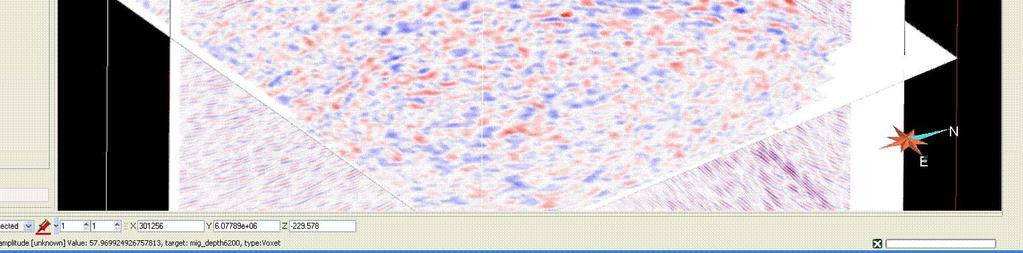
7 N Correlation between reflectivity and the mine horizon? S 0m 3000m Line 8 Migrated Stack


8 Flin Flon Vicinity Missi Hidden fm Millrock mbr Blue Lagoon mbr


9 Line 8 Do we see the ore bodies? Calinan Line FF Main

10 W E 3000 m Line 3


11


12


13
14 Direct targeting from the 2D/3D Seismic experiment Sask. Man. Cliff Lake CLF Tailings pond RWF T HLS 10 Ross Lake Lakeview Lakeview showing Channing fault Lakeview showing: Drilled VMS prospect.9% Cu, 1.0% Zn over 8 m 106 BRA N S 10a Mud Lake Legend Intrusive Rocks Phantom, Kaminis, Annabel, Cliff Lake plutons Boundary intrusions Myo felsic intrusion Missi Group Miss Group Flin Flon Arc Assemblage Louis and Douglas formations Hidden and Newcor formations Are there extensions of the Lakeview showing below the Missi basin? member Flin Flon formation Milrock member Creighton member BLF Schist Lake Blue Lagoon member Club member RLF Unassigned volcanic rocks Phantom Lake Hook Lake Block Unassigned volcanic rocks Mine Shaft T - Triple 7, N - North Main, S - South Main VMS deposit C - Callinan, T - Triple 7 F - Flin Flon, M - Mandy S - Schist Lake ore surface expression fault anticline syncline


15 Blind thrust of volcanic rocks perched in Missi basin sediments? 0m Missi basin Mud Lake thrust Unconformity Amisk volcanics N S 3000m Line 9 Migrated Stack


16 3D model including new DDH FFM 006 FFM001 FFM006 Lakeview reflector FFM003 FFM002 Lakeview volcanics Missi unconformity FFM004 Modelled extension Opens up a large area of the Missi basin to exploration Target reflector of volcanic extension Channing fault Disseminated Po +/- Cpy In altered basalt View looking NNW


")

17 3D Modelling Subproject DRILL HOLE DATA: 3600 holes MINE MODELS (ORE SHELLS AND FAULTS) GEOLOGICAL MAP DATA 3D AND 2D SEISMIC DATA


18 Stratigraphic relogging Club Lake thrust Flin Flon Vicinity Railway fault Has Club Lk fault over-ridden another thrust at depth? Bright zone


19 Multiple phases of thrust stacking of the mine horizon Early imbricate west-vergent (?) stack re-imbricated by post-missi basin north-vergent stack Two repeated units of the Millrock Member-mine horizon Later imbricates sole to south into internally shortened mine horizon E. Schetselaar and M. Currie
20 Identification of fault zones Post-Missi generation: Relatively easy 1082 m level 777 mine Railway fault type section Early generation: Easily missed without stratigraphic control: mm thick


21 Significant implications for exploration Callinan panel 2 Missi sedimentary cover Hidden basalts Millrock member heterolithic volcanics & rhyolite Blue Lagoon member sulphide-bearing graphitic argillite - distal equivalent Opens up potential for hangingwall and footwall targets: directly above or below the present mines Instead of down plunge 777 panel Blind panel 3

22 Integrated targeting CLF Tailings pond 167 BRA Sask. Man. RWF N S T HLS Phantom Lake Ross Lake BLF Cliff Lake 1920 member Flin Flon formation Co-operative Milrock member Creighton member mapping 10a Club member 10 Hook Lake Block Unassigned volcanic by SMER, rocks Mine Shaft T - Triple 7 N - North Main MGS, TGI-1 S - South Main VMS deposit C - Callinan T - Triple 7 TGI-3, F - Flin Flon M - Mandy S - S chi st L ake ore surface expression Laurentian Schist fault Lake anticline syncline University and HBED 10 RLF Mud Lake Legend Intrusive Rocks Phantom, Kaminis, Annabel, Cliff Lake plutons Boundary intrusions Myo felsic intrusion Missi Group Miss Group Flin Flon Arc Assemblage Louis and Douglas formations Hidden and Newcor formations Blue Lagoon member Unassigned volcanic rocks Simard et al., In prep Kilometers
23 Flin Flon fm Hidden fm Creighton Mb Millrock Mb N Volcanologic mapping identified possible vent proximal setting Millrock Hill Phantom Lake Peninsula S Green Lake Peninsula Hidden Formation Flin Flon Formation Millrock mb Sparsely plag and px-phyric pillowed and massive flows/sills Mafic tuff and lapilli tuff Aphyric massive flows and amoeboid flow breccia Felsic tuff Aphyric mafic flows Mafic to intermediate ash tuff and crystal tuff Heterolithic mafic and felsic breccia Sparsely plag +/- px-phyric pillowed and massive flows/sills Bedded heterolithic mafic tuff breccia-lapilli tuff Resedimented rhyolite breccia Quartz -phyric rhyolite flows/domes and cryptodomes Creighton mb Plagioclase-phyric mafic flows Aphyric amygdaloidal pillowed mafic flows Normal Fault MacLachlan, 2008


24 1920 unit: Vent proximal icelandite STRATIGRAPHY FACIES Spatially associated with main Flin Flon caldera Louis Formation 1920 unit Hidden Formation Millrock member Blue Lagoon member FOOTWALL HANGING WALL VMS Millrock mb Blue Lagoon mb Hidden fm Louis fm Flin Flon fm Distinctive geochemically: Hi Ti and P andesite Sometimes distinctive texturally: Amphibole needle dacite 26 surface sites and 12 drill hole Intersections now known outside type area: Including FFS014 and FFS012 Club member Club mb Aphyric to sparsely plagioclase-phyric mafic flows Plagioclase-phyric mafic flows Plagioclase-Pyroxene-phyric mafic flows Icelandite Silicified spatter breccia Porphyriticc mafic volcaniclastic rocks Aphyric mafic volcaniclastic rocks Rhyolitic flows Felsic breccia Laminated mafic/mafic+felsic tuff VMS lenses FFS014 FFS012


25 Phantom Beach logged holes Phantom Beach Mineralized argillite within mine horizon rhyolite: 1500 ppm Zn, 300 ppm Cu and elevated Ag, Sb, As, Hg: Equivalent horizon to the ore interval?


26 Hangingwall Thermal Corridors Mineralogical, geochemical and alteration mapping study has identified corridors of high temperature upflow in Hidden Formation hangingwall basalts above: Flin Flon caldera Callinan-777 orebodies the Phantom Beach area Ames, in prep

27 Seismic targeting

28 Bright anomaly down plunge of mineralized argillite in FFS015 Line 1 migrated Line 7 migrated FFS015 W E


29 Acknowledgements Saskatchewan Energy and Resources Manitoba Geological Survey HudBay Exploration and Development: Christine Devine and Kelly Gilmore
Flin Flon 1:10k compilation map
 Flin Flon 1:10k compilation map An update on mapping, stratigraphy, geochem, etc by Renée-Luce Simard, Manitoba Geological Survey Michelle DeWolfe, Laurentian University Kate MacLachlan, Saskatchewan Industry
Highlights from New Flin Flon mining camp map and New mapping project in the sub- Phanerozoic Flin Flon Belt
 Highlights from New Flin Flon mining camp map and New mapping project in the sub- Phanerozoic Flin Flon Belt Manitoba Mines and Minerals Convention 2009 Renée-Luce Simard Manitoba Geological Survey Outline
Highlights of the New 1: scale Geology Map of the Flin Flon Area, Manitoba and Saskatchewan (parts of NTS 63K/12 and /13) 1
 1") Highlights of the New 1:10 000-scale Geology Map of the Flin Flon Area, Manitoba and Saskatchewan (parts of NTS 63K/12 and /13) 1 R-L. Simard 2 and K. MacLachlan Simard, R-L. and MacLachlan, K. (2009):
Highlights of the New 1:10 000-scale Geology Map of the Flin Flon Area, Manitoba and Saskatchewan (parts of NTS 63K/12 and /13) 1 R-L. Simard 2 and K. MacLachlan Simard, R-L. and MacLachlan, K. (2009):
Stratigraphy of VMS-hosting Volcanic and Volcaniclastic Rocks of the Flin Flon Formation, Flin Flon Creighton area, Saskatchewan and Manitoba
 Stratigraphy of VMS-hosting Volcanic and Volcaniclastic Rocks of the Flin Flon Formation, Flin Flon Creighton area, Saskatchewan and Manitoba C.A. Devine 1, H.L. Gibson 1, A.H. Bailes 2, K. MacLachlan,
Geology of the Schist Lake Mandy mines area, Flin Flon, Manitoba (part of NTS 63K12) by R-L. Simard
 by R-L. Simard") GS-1 Geology of the Schist Lake Mandy mines area, Flin Flon, Manitoba (part of NTS 63K12) by R-L. Simard Simard, R-L. 2006: Geology of the Schist Lake Mandy mines area, Flin Flon, Manitoba (part of NTS
GS-1 Geology of the Schist Lake Mandy mines area, Flin Flon, Manitoba (part of NTS 63K12) by R-L. Simard Simard, R-L. 2006: Geology of the Schist Lake Mandy mines area, Flin Flon, Manitoba (part of NTS
Figure GS-1-1: Tectonic assemblages of the Flin Flon Belt, with locations of contained VMS deposits (modified from Syme et al., 1996).
.") GS-1 STRATIGRAPHY OF VOLCANOGENIC MASSIVE SULPHIDE-HOSTING VOLCANIC AND VOLCANICLASTIC ROCKS OF THE FLIN FLON FORMATION, FLIN FLON (NTS 63K12 AND 13), MANITOBA AND SASKATCHEWAN by C.A. Devine 1, H.L. Gibson
GS-1 STRATIGRAPHY OF VOLCANOGENIC MASSIVE SULPHIDE-HOSTING VOLCANIC AND VOLCANICLASTIC ROCKS OF THE FLIN FLON FORMATION, FLIN FLON (NTS 63K12 AND 13), MANITOBA AND SASKATCHEWAN by C.A. Devine 1, H.L. Gibson
Geology of the Hook Lake Block, Flin Flon area, Manitoba (part of NTS 63K12) by P.D. Kremer and R-L. Simard
 by P.D. Kremer and R-L. Simard") GS-2 Geology of the Hook Lake Block, Flin Flon area, Manitoba (part of NTS 63K12) by.d. Kremer and R-L. Simard Kremer,.D. and Simard, R-L. 2007: Geology of the Hook Lake Block, Flin Flon area, Manitoba
GS-2 Geology of the Hook Lake Block, Flin Flon area, Manitoba (part of NTS 63K12) by.d. Kremer and R-L. Simard Kremer,.D. and Simard, R-L. 2007: Geology of the Hook Lake Block, Flin Flon area, Manitoba
Structural geology and gold metallogeny of the New Britannia mine area, Snow Lake, Manitoba
 Structural geology and gold metallogeny of the New Britannia mine area, Snow Lake, Manitoba Chris Beaumont-Smith Manitoba Geological Survey Boundary zone New Britannia Trans-Hudson Orogen 50 km 100 km
Ernst Schetselaar, Gilles Bellefleur, Nadjib El Goumi
 3D Integration of seismic, petrophysical and lithogeochemical data to elucidate the effects of hydrothermal alteration on the seismic response of the Lalor VMS footwall sequence Ernst Schetselaar, Gilles
ESKAY CREEK MINE. Rob Boyce, P. Geo. G\GROUP\GEOLOGY\EXPLORE\EXPL2001\BUDSAN1
 ESKAY CREEK MINE Rob Boyce, P. Geo. G\GROUP\GEOLOGY\EXPLORE\EXPL2001\BUDSAN1 Outline Location Geology Production Recent Exploration Future of Eskay Creek Location and Transportation From Kitwanga Ore and
VECTORING VOLCANOGENIC MASSIVE SULPHIDE MINERALIZATION AT THE RAINDROP ZONE, SNOW LAKE (NTS 63K16), MANITOBA by G.H. Gale
, MANITOBA by G.H. Gale") GS-8 VECTORING VOLCANOGENIC MASSIVE SULPHIDE MINERALIZATION AT THE RAINDROP ZONE, SNOW LAKE (NTS 63K16), MANITOBA by G.H. Gale Gale, G.H. 2002: Vectoring volcanogenic massive sulphide mineralization at
GS-8 VECTORING VOLCANOGENIC MASSIVE SULPHIDE MINERALIZATION AT THE RAINDROP ZONE, SNOW LAKE (NTS 63K16), MANITOBA by G.H. Gale Gale, G.H. 2002: Vectoring volcanogenic massive sulphide mineralization at
Re-assessment of Bird River greenstone belt stratigraphy. Paul Gilbert Manitoba Geological Survey
 Re-assessment of Bird River greenstone belt stratigraphy Paul Gilbert Manitoba Geological Survey Location of Bird River Belt Bird River Belt Winnipeg Bird River Belt projects initiated in 2005 Paul Gilbert
New insights on the THO-Superior boundary: Tectonic and metallogenic implications
 New insights on the THO-Superior boundary: Tectonic and metallogenic implications John Percival, GSC Nicole Rayner, GSC Herman Zwanzig, MGS Linda Murphy, MGS Joe Whalen, GSC Martha Growdon, Indiana U.
Bird River Belt in southeastern Manitoba: a Neoarchean volcanic arc in the Western Superior Province. Paul Gilbert Manitoba Geological Survey
 Bird River Belt in southeastern Manitoba: a Neoarchean volcanic arc in the Western Superior Province Paul Gilbert Manitoba Geological Survey Location of Bird River Belt Bird River Belt Winnipeg Bird River
High Resolution Seismic for Minerals
 High Resolution Seismic for Minerals Greg Turner HiSeis Pty Ltd MEGWA April 2013 WELCOME HiSeis Pty Ltd, Suite 4 Enterprise Unit 3, 9 DeLaeter Way, Bentley, WA 6102 Ph: +61 8 9470 9866 www.hiseis.com Used
Copper Reef to Drill Massive Sulphide Targets in Flin Flon
 12 Mitchell Road Tel: (204) 687-3500 Flin Flon, MB, R8A 1N1 CZC.CSE Fax: (204) 687-4762 copperreef.com February 28, 2019. Copper Reef to Drill Massive Sulphide Targets in Flin Flon Copper Reef Mining Corporation
THE VOLCANIC STRATIGRAPHY AND ALTERATION OF THE SCHIST LAKE AND MANDY MINES DEPOSITS, FLIN FLON, MANITOBA
 THE VOLCANIC STRATIGRAPHY AND ALTERATION OF THE SCHIST LAKE AND MANDY MINES DEPOSITS, FLIN FLON, MANITOBA by EILIDH MURRAY LEWIS Thesis submitted in partial fulfillment of the requirements for the degree
The Cobalt Rainbow. Airborne geophysical maps show that a north trending aeromagnetic high suggests further undiscovered mineralisation.
 The Cobalt Rainbow The property is located on Greenstone Creek, approximately 4.8 kilometres south west of the creek mouth. The property is located about 24 km due west of Campbell River, in the east-central
Lands Parcels in IOL CO-20
 Lands Parcels in IOL CO-20 1 CO-20 The Izok Corridor Lupin - multi-million ounce past gold production (3.6 million oz of gold at average grade of 9.3 g/t Au) Approximately 1 million ounces of undeveloped
Towards a new stratigraphy of the Bird River Belt. H.P. Gilbert (MGS)
") Towards a new stratigraphy of the Bird River Belt H.P. Gilbert (MGS) Bird River Belt projects initiated in 2005 1. Paul Gilbert (MGS) Regional mapping (1: 20 000 scale) with focus on stratigraphy and geochemistry
Towards a new stratigraphy of the Bird River Belt H.P. Gilbert (MGS) Bird River Belt projects initiated in 2005 1. Paul Gilbert (MGS) Regional mapping (1: 20 000 scale) with focus on stratigraphy and geochemistry
The MAPLE BAY PROJECT Copper Silver - Gold
 The MAPLE BAY PROJECT Copper Silver - Gold Good grade and tonnage potential within close proximity to Tidewater The Maple Bay Copper Silver Gold Project covers highly favourable geological host rocks of
STATION #1 Compaction and Cementation
 STATION #1 Compaction and Cementation STATION #2 High Temperature and Pressure STATION #3 Sediments Examples: Glacial deposits: gravel, sand, clay River and lake deposits: gravel, sand, mud Sand dunes
Using 3D/4D modeling tools in exploration of gold-polymetallic potential areas in Greece
 Using 3D/4D modeling tools in exploration of gold-polymetallic potential areas in Greece Arvanitidis N.D., Michael C., Weihed P., Gaál l G., Royer J.J., Perantonis G., Bakalis V., Ballas D. and Christidis
Report of Activities 2003 Published by: Manitoba Industry, Economic Development and Mines Manitoba Geological Survey, 2003.
 Report of Activities 2003 Published by: Manitoba Industry, Economic Development and Mines Manitoba Geological Survey, 2003. ERRATA: The publisher/department name in the bibliographic reference cited immediately
Outline. A. Carlson, U of M summer student
 Manitoba Manitoba Mining Mining & & Minerals Minerals Convention Convention 2005 2005 An appraisal of the potential for volcanic volcanic-hosted massive sulphide (VHMS) deposits in the Archean Rice Lake
Bigstone: A High Grade VMS Deposit in the Western Flin Flon- Glennie Complex
 Bigstone: A High Grade VMS Deposit in the Western Flin Flon- Glennie Complex Dave Fleming, VP Exploration *Roger March, VP Project Exploration Saskatchewan Geological Survey Open House December 1, 2015
CHAMPION BEAR RESOURCES
 CHAMPION BEAR RESOURCES EXPLORING ADVANCED STAGE PRECIOUS METAL PROPERTIES IN ONTARIO Exploration Update January 2011 Forward Looking Statements This exploration update contains forward looking statements
KIRKLAND LAKE GOLD EXPANDS NEW HIGH-GRADE ZONE BELOW TAYLOR MINE, REPORTS MINERALIZED EXTENSIONS ALONG STRIKE AND AT DEPTH
 KIRKLAND LAKE GOLD EXPANDS NEW HIGH-GRADE ZONE BELOW TAYLOR MINE, REPORTS MINERALIZED EXTENSIONS ALONG STRIKE AND AT DEPTH New gold zone intersected 500 metres ( m ) below existing mining and mine infrastructure
Sombrero Butte Copper Project Arizona, USA
 Sombrero Butte Copper Project Arizona, USA January 2017 Sombrero Butte Project Location COPPER CREEK DEPOSIT (7.75 Billion Lbs Cu) SAN MANUEL KALAMAZOO MINE (BHP) (10.4 Billion Lbs Cu) SOMBRERO BUTTE EXPLORATION
Magmatic-Hydrothermal Gold Systems in the Archean of Northern Ontario, Canada: Examples of Syenite-Associated and Porphyry-Type Au-(Cu) Deposits
 Deposits") Magmatic-Hydrothermal Gold Systems in the Archean of Northern Ontario, Canada: Examples of Syenite-Associated and Porphyry-Type Au-(Cu) Deposits By Dr. Daniel J. Kontak Department of Earth Sciences Laurentian
Magmatic-Hydrothermal Gold Systems in the Archean of Northern Ontario, Canada: Examples of Syenite-Associated and Porphyry-Type Au-(Cu) Deposits By Dr. Daniel J. Kontak Department of Earth Sciences Laurentian
Geological investigation of the McLeod Road Birch Lake allochthon east of Snow Lake, Manitoba (part of NTS 63J13) by S. Gagné
 by S. Gagné") GS-6 Geological investigation of the McLeod Road Birch Lake allochthon east of Snow Lake, Manitoba (part of NTS 63J13) by S. Gagné Gagné, S. 2009: Geological investigation of the McLeod Road Birch Lake
GS-6 Geological investigation of the McLeod Road Birch Lake allochthon east of Snow Lake, Manitoba (part of NTS 63J13) by S. Gagné Gagné, S. 2009: Geological investigation of the McLeod Road Birch Lake
CSA Mine Observations Applied to the Development of Regional Exploration Models
 CSA Mine Observations Applied to the Development of Regional Exploration Models 1 Introduction Recent work completed by the geology team has resulted in an improved understanding of the CSA mine system
GS-1. by A. H. Bailes and D.C.P. Schledewitz SUMMARY INTRODUCTION
 GS-1 GEOLOGY AND GEOCHEMISTRY OF PALEOPROTEROZOIC VOLCANIC ROCKS BETWEEN THE MCLEOD ROAD AND BIRCH LAKE FAULTS, SNOW LAKE AREA, FLIN FLON BELT (PARTS OF NTS 63K/16 AND 63J/13) by A. H. Bailes and D.C.P.
Page 1. Name: 1) Which diagram best shows the grain size of some common sedimentary rocks?
 Which diagram best shows the grain size of some common sedimentary rocks?") Name: 1) Which diagram best shows the grain size of some common sedimentary rocks? 1663-1 - Page 1 5) The flowchart below illustrates the change from melted rock to basalt. 2) Which processes most likely
Name: 1) Which diagram best shows the grain size of some common sedimentary rocks? 1663-1 - Page 1 5) The flowchart below illustrates the change from melted rock to basalt. 2) Which processes most likely
NEWS RELEASE CANADIAN ZINC REPORTS REMAINING DRILL RESULTS AT LEMARCHANT DEPOSIT, SOUTH TALLY POND PROJECT, NEWFOUNDLAND
 NEWS RELEASE CZN-TSX CZICF-OTCQB FOR IMMEDIATE RELEASE March 5, 2018 CANADIAN ZINC REPORTS REMAINING DRILL RESULTS AT LEMARCHANT DEPOSIT, SOUTH TALLY POND PROJECT, NEWFOUNDLAND 2017 drill program successfully
twd$ yqsi+hca
 -t@~cl--t,i twd$ yqsi+hca C ASSESSMENT REPORT ON THE OR0 1-5 CLAIMS NEAR GOLDBRIDGE, B.C. Lillooet Mining Division N.T.S. 92 J / 15 W Long. 122 51.5 W. Lat. 50 47.5 N. Owned by Levon Resources Ltd. Optioned
GEOLOGY OF THE NICOLA GROUP BETWEEN MISSEZULA LAKE AND ALLISON LAKE
 GEOLOGY OF THE NICOLA GROUP BETWEEN MISSEZULA LAKE AND ALLISON LAKE (92H/15E. 10E1 By V. A. Preto INTRODUCTION Mapping was continued southward from the area covered in 1973 and an additional 55 square
Ore-Associated and Barren Rhyolites in the Central Flin Flon Belt: Case Study of the Flin Flon Mine Sequence
 Open File Report OF98-9 Ore-Associated and Barren Rhyolites in the Central Flin Flon Belt: Case Study of the Flin Flon Mine Sequence Manitoba Energy and Mines David Newman Minister Manitoba Energy and
GEOLOGY OF THE ALBERTS LAKE AREA (NTS 64K13SE AND 14SW), MANITOBA by H.P. Gilbert
, MANITOBA by H.P. Gilbert") GS-5 GEOLOGY OF THE ALBERTS LAKE AREA (NTS 64K13SE AND 14SW), MANITOBA by H.P. Gilbert Gilbert, H.P. 2002: Geology of the Alberts Lake area (NTS 63K13SE and 14SW), Manitoba; in Report of Activities 2002,
GS-5 GEOLOGY OF THE ALBERTS LAKE AREA (NTS 64K13SE AND 14SW), MANITOBA by H.P. Gilbert Gilbert, H.P. 2002: Geology of the Alberts Lake area (NTS 63K13SE and 14SW), Manitoba; in Report of Activities 2002,
The Future of Base Metal Exploration and Mining in Canada
 HBM The Future of Base Metal Exploration and Mining in Canada Kelly Gilmore Peter Wood Toronto Geological Discussion Group November 8, 2012 Forward Looking Information Future Base Metal Exploration and
Northern Flin Flon Belt compilation, Manitoba (parts of NTS 63K12, 13) by H.P. Gilbert
 by H.P. Gilbert") GS-7 Northern Flin Flon Belt compilation, Manitoba (parts of NTS 63K12, 13) by H.P. Gilbert Gilbert, H.P. 2010: Northern Flin Flon Belt compilation, Manitoba (parts of NTS 63K12, 13); in Report of Activities
GS-7 Northern Flin Flon Belt compilation, Manitoba (parts of NTS 63K12, 13) by H.P. Gilbert Gilbert, H.P. 2010: Northern Flin Flon Belt compilation, Manitoba (parts of NTS 63K12, 13); in Report of Activities
Magnus Copper Project exploration update
 ASX ANNOUNCEMENT 30 SEPTEMBER 2011 CODE: ALY BOARD OF DIRECTORS Mr Warwick Davies Non-Executive Chairman Mr Robert Brierley Managing Director Mr John Arbuckle Non-Executive Director Mr Jeffrey Moore Non-Executive
FIRST YEAR ASSESSMENT REPORT ON THE HAMMERDOWN SOUTH PROPERTY KING S POINT AREA, NEWFOUNDLAND
 FIRST YEAR ASSESSMENT REPORT ON THE HAMMERDOWN SOUTH PROPERTY KING S POINT AREA, NEWFOUNDLAND Licenses: 017558M, 017559M, 017560M and 017561M NTS Mapsheets: 012H/08 and 012H/09 Garry Fraser 66a Frontenac
Chapter 10. Chapter Rocks and the Rock Cycle. Rocks. Section 1 Rocks and the Rock Cycle
 Chapter 10 Rocks 1 Chapter 10 Section 1 Rocks and the Rock Cycle 2 10.1 Rocks and the Rock Cycle Magma is the parent material for all rocks. Once the magma cools and hardens, many changes can occur. Geology:
SbTe 4. ), two unknown Pd telluride-antimonide minerals, sudburyite (PdSb), sperrylite (PtAs 2. ), temagamite (Pd 3. HgTe 3
, two unknown Pd telluride-antimonide minerals, sudburyite (PdSb), sperrylite (PtAs 2. ), temagamite (Pd 3. HgTe 3") GS-12 PLATINUM GROUP ELEMENT INVESTIGATIONS IN THE FLIN FLON GREENSTONE BELT: PETROGRAPHY AND MINERALOGY OF THE MCBRATNEY LAKE PGE-AU OCCURRENCE (NTS 63K13), MANITOBA by G. Olivo 1, P. Theyer and N. Bursztyn
GS-12 PLATINUM GROUP ELEMENT INVESTIGATIONS IN THE FLIN FLON GREENSTONE BELT: PETROGRAPHY AND MINERALOGY OF THE MCBRATNEY LAKE PGE-AU OCCURRENCE (NTS 63K13), MANITOBA by G. Olivo 1, P. Theyer and N. Bursztyn
Mineral Exploration Research Centre, Harquail School of Earth Sciences, Laurentian University, Sudbury, Ontario, P3E 2C6, Canada
 Volcanic stratigraphy and intrusions in the Renault Dufresnoy and Duprat Montbray formations: implications for metal endowment in the lower Blake River group, Rouyn-Noranda, Quebec Jonathan Sutton, Harold
COPPERSTONE RESOURCES AB INTERCEPTS ZONE OF CHALCOPYRITE-ARSENOPYRITE- BORNITE MINERALIZATION AT SVARTLIDEN IN FIRST DEEP DRILLHOLE FROM 720m-810m
 COPPERSTONE RESOURCES AB INTERCEPTS ZONE OF CHALCOPYRITE-ARSENOPYRITE- BORNITE MINERALIZATION AT SVARTLIDEN IN FIRST DEEP DRILLHOLE FROM 720m-810m In mid-january 2017 Copperstone Resource published a geological
Chapter 4 Rocks & Igneous Rocks
 Chapter 4 Rocks & Igneous Rocks Rock Definition A naturally occurring consolidated mixture of one or more minerals e.g, marble, granite, sandstone, limestone Rock Definition Must naturally occur in nature,
Geology 12 Exam Review Package
 Geology 12 Exam Review Package Exam Date: Supplies: Thursday June 11 th, 1:00pm to 4:00pm Pen, pencil, eraser, calculator (all graphing calculators will have their memories cleared at the start of the
The Lalor Deposit: A New Discovery in Canada. Kelly Gilmore PDAC March 4, 2009
 The Lalor Deposit: A New Discovery in Canada Kelly Gilmore PDAC March 4, 2009 ForwardLooking Information This presentation contains "forwardlooking information" within the meaning of applicable Canadian
Stratigraphic, volcanologic and sedimentological architecture of the Swayze area, Abitibi greenstone belt
 Stratigraphic, volcanologic and sedimentological architecture of the Swayze area, Abitibi greenstone belt Swayze? Swayze Timmins DPFZ Swayze greenstone belt Geology map Nat River complex Slate Rock DZ
 19 00' N 70 20' W Loma La Cuaba volcanic edifice 70 00' W Pueblo Viejo District (location of Fig. 2) Loma Navisa volcanic edifice 69 40' W & S a m a n á B a y 0 10 20 Kilometers 18 50' N Guaimarote Hatillo
it AUSIMM COBAR MINING SEMINAR
 Straits Resources Limited it AUSIMM COBAR MINING SEMINAR Brownfields Exploration at Girilambone: Understanding the Mineralised Systems August 2010 Phil Shields / Phil Jones LOCATION TRITTON OPERATIONS
NEWS RELEASE FOR IMMEDIATE RELEASE: MARCH 5, 2018
 NEWS RELEASE FOR IMMEDIATE RELEASE: MARCH 5, 2018 Eskay Mining provides update on ongoing geological review - Targeting E&L-Type Nickel-Copper-PGE and Eskay-Type VMS Potential on Its Golden Triangle Holdings:
Project Review. Sturgeon Lake Property
 Project Review Sturgeon Lake Property For Excalibur Resources Ltd. James M Franklin PhD FRSC P Geo March 12, 2012 1 Executive Summary The Excalibur Claim group, located about 130km north of Upsala Ontario,
Gidji Lake formation -
 Gidji Lake formation - Key Stratigraphic marker for World Class Gold Deposits of Kalgoorlie Presentation to CSIRO - July 2017 Please reference this document if the slides, figures or concepts are to be
The metamorphic events (full details below) consist of: Special session: Metamorphism in the ore environment One of W-Th-F May , 2013
 consist of: Special session: Metamorphism in the ore environment One of W-Th-F May , 2013") This is an announcement for a paired special session and field trip concerned with metamorphosed ore deposits, to be held at the GAC- MAC Joint Annual Meeting in Winnipeg, May 22-28, 2013. The metamorphic
This is an announcement for a paired special session and field trip concerned with metamorphosed ore deposits, to be held at the GAC- MAC Joint Annual Meeting in Winnipeg, May 22-28, 2013. The metamorphic
Copper and Zinc Production, Disciplined Growth. S I T E V I S I T O C T O B E R % Owned Projects
 Copper and Zinc Production, Disciplined Growth. S I T E V I S I T O C T O B E R 2 0 1 6 100% Owned Projects Serbia assets Timok Magmatic Complex Rakita Joint Venture 4 exploration permits in the Bor region,
Gold Mineralization Potential in a Wabigoon Subprovince Granite-Greenstone Terrane, International Falls Area, Minnesota
 Gold Mineralization Potential in a Wabigoon Subprovince Granite-Greenstone Terrane, International Falls Area, Minnesota Manitoba Ontario Mn The State of Minnesota is located in the north-central portion
Nachicapau Zn-Cu project THE NEXT MAJOR DISCOVERER IN QUEBEC
 Nachicapau Zn-Cu project THE NEXT MAJOR DISCOVERER IN QUEBEC Nachicapau Project - Location Willbob & Pallas Projects Kuujjuaq Located about 150km south of Kuujjuaq, the closest community (has a port) 215
Preliminary results of the Flin Flon Targeted Geoscience Initiative, Saskatchewan and Manitoba
 Geological Survey of Canada CURRENT RESEARCH 2002-C24 Preliminary results of the Flin Flon Targeted Geoscience Initiative, Saskatchewan and Manitoba Alan Galley, Alan Bailes, Harold Gibson, Ghislain Tourigny,
LAB 2 IDENTIFYING MATERIALS FOR MAKING SOILS: ROCK AND PARENT MATERIALS
 LAB 2 IDENTIFYING MATERIALS FOR MAKING SOILS: ROCK AND PARENT MATERIALS Learning outcomes The student is able to: 1. understand and identify rocks 2. understand and identify parent materials 3. recognize
Diamondiferous Kimberlites of Central Saskatchewan Project: Update
 Diamondiferous Kimberlites of Central Saskatchewan Project: Update S.E. Harvey, J.-P. Zonneveld 1, and B.A. Kjarsgaard 2 Harvey, S.E., Zonneveld, J.-P., and Kjarsgaard, B.A. (2003): Diamondiferous Kimberlites
Introduction. Lake KISSEYNEW BELT SOUTH FLANK. Kisseynew Lake. Flin Flon assemblage. Figure GS-9-2. assemblage West Amisk assemblage
 GS-9 Characteristics and controls of gold mineralization in the Brunne area of the Flin Flon belt, west-central Manitoba (parts of NTS 63K11, 14) by J.A. Dunn¹ and S. Gagné Dunn, J.A. and Gagné, S. 2014:
New gold discovery in the Paleoproterozoic Mauken greenstone belt
 New gold discovery in the Paleoproterozoic Mauken greenstone belt Mauken greenstone belt The Paleoproterozoic Mauken greenstone belt is situated in an unexplored and untested terrain in Northern Norway.
Pelican Narrows Project - Update
 Pelican Narrows Project - Update R. Maxeiner and N. Rayner Objective of Pelican Narrows project Overview of previously completed geochronology and regional geology Quick review of geology of the Kakinagimak
Igneous Rock Classification, Processes and Identification Physical Geology GEOL 100
 Igneous Rock Classification, Processes and Identification Physical Geology GEOL 100 Ray Rector - Instructor Major Concepts 1) Igneous rocks form directly from the crystallization of a magma or lava 2)
Anthill Resources Yukon - An Update on the Einarson Project
 Anthill Resources Yukon - An Update on the Einarson Project The Eastern Extension of a Carlin-type Gold Trend in the Selwyn Basin Anthill Resources Ltd Yukon Claim Holdings Over 2400 km 2 Property Location
GLY 155 Introduction to Physical Geology, W. Altermann. Grotzinger Jordan. Understanding Earth. Sixth Edition
 Grotzinger Jordan Understanding Earth Sixth Edition Chapter 4: IGNEOUS ROCKS Solids from Melts 2011 by W. H. Freeman and Company Chapter 4: Igneous Rocks: Solids from Melts 1 About Igneous Rocks Igneous
Alcoutim Cu-Zn Portugal Drilling and Technical Update
 4 July 2017 Market Announcements Platform ASX Limited Exchange Centre 20 Bridge Street Sydney NSW 2000 Alcoutim Cu-Zn Portugal Drilling and Technical Update Highlights Access to historical data and drilling
IMC EXPLORATION GROUP PLC. AVOCA Au-Cu-Zn PROJECT DR BILL SHEPHARD
 IMC EXPLORATION GROUP PLC DR BILL SHEPHARD Figure 2 Introduction Massive Ore, West Avoca West Avoca towards the Goldmines River IMC has recently acquired exploration rights to two licences adjacent to
GEOLOGY AND LITHOGEOCHEMISTRY OF THE CHILKO-TASEKO LAKES AREA* BY G.
 B Ministry of Energy, Mines and Petroleum Resources GEOLOGICAL BRANCH MINERAL RESOURCES DIVISION NOTES TO ACCOMPANY OPEN FILE - GEOLOGY AND LITHOGEOCHEMISTRY OF THE CHILKO-TASEKO LAKES AREA* BY G. P. McLAREN
Evaluating the Intrusion-Related Model for the Archean Low-Grade, High- Tonnage Côté Gold Au(-Cu) Deposit
 Deposit") Evaluating the Intrusion-Related Model for the Archean Low-Grade, High- Tonnage Côté Gold Au(-Cu) Deposit L.R. Katz, D.J. Kontak, Laurentian University, B. Dubé, V. McNicoll, Geological Survey of Canada
Evaluating the Intrusion-Related Model for the Archean Low-Grade, High- Tonnage Côté Gold Au(-Cu) Deposit L.R. Katz, D.J. Kontak, Laurentian University, B. Dubé, V. McNicoll, Geological Survey of Canada
State Metallic Minerals Lease Sale Minnesota s Vermilion Gold District
 State Metallic Minerals Lease Sale Minnesota s Vermilion Gold District State Metallic Minerals Lease Sale Notice of Intent Scale 1:100,000 State Metallic Minerals Lease Sale This portion of the lease sale
Page 1. Name:
 Name: 1) What is the approximate density of a mineral with a mass of 262.2 grams that displaces 46 cubic centimeters of water? A) 6.1 g/cm 3 C) 1.8 g/cm 3 B) 5.7 g/cm 3 D) 12.2 g/cm 3 2) In which two Earth
3-D D Interpretation Team example from Blake River Group. Strategy Meeting (summary) October , Ottawa
 October , Ottawa") 3-D D Interpretation Team example from Blake River Group Strategy Meeting (summary) October 16-17 17 2006, Ottawa Participants to Date: Jean Goutier MRNF John Percival - NRCAN Eric de Kemp NRCAN Marc Legault
3-D D Interpretation Team example from Blake River Group Strategy Meeting (summary) October 16-17 17 2006, Ottawa Participants to Date: Jean Goutier MRNF John Percival - NRCAN Eric de Kemp NRCAN Marc Legault
Bedrock mapping and geological characterization in the northern Glennie domain, west-central Reindeer Zone
 Bedrock mapping and geological characterization in the northern Glennie domain, west-central Reindeer Zone Samantha Van De Kerckhove, Ryan Morelli and Dylan Deck Saskatchewan Geological Open House, 2017
TSX.V: RG OTC-PK: RMIOF FRANKFURT: D4R. Lundmark-Akow Lake Project: A new Cu-Au-Ag Massive Sulphide Discovery in NW Ontario
 TSX.V: RG OTC-PK: RMIOF FRANKFURT: D4R Lundmark-Akow Lake Project: A new Cu-Au-Ag Massive Sulphide Discovery in NW Ontario Tel: (416) 221-4124 Fax: (416) 218-9772 E-mail: romios@romios.com Web: www.romios.com
New geologic mapping + and associated economic potential on northern Hall Peninsula, Baffin Island, Nunavut
 New geologic mapping + and associated economic potential on northern Hall Peninsula, Baffin Island, Nunavut Holly Steenkamp, M.Sc. Regional Mapping Geoscientist David Mate, M.Sc. Chief Geologist November
Igneous Rocks. Igneous Rocks - 1. Environment of Formation - Magma - Plutonic - rock that formed within the Earth. Intrusive - Earth s crust.
 Name: Date: Period: Minerals and Rocks The Physical Setting: Earth Science CLASS NOTES - Methods to classify igneous rocks: 1. Environment of Formation - Magma - Plutonic - rock that formed within the
Queenston intersects Contact Zone on the Pandora Property and new gold zones in Kirkland Lake
 1 Queenston intersects Contact Zone on the Pandora Property and new gold zones in Kirkland Lake TORONTO, Ontario, March 7, 2003. Queenston Mining Inc. (QMI-TSX) reports diamond drill results on its 100%
NEWS RELEASE. Foran Intersects Over 28 Metres of Copper Mineralization
 NEWS RELEASE Foran Intersects Over 28 Metres of Copper Mineralization Vancouver, BC (May 7, 2018) - Foran Mining Corporation (TSX.V: FOM) ( Foran or the Company ) announces results of two additional drill
The following is an amended version of the announcement made earlier today to reflect that three holes have been completed rather than two.
 (A.B.N. 96 095 684 389) P.O. Box 7996 Telephone: (07) 5592 2274 Gold Coast Mail Centre Facsimile: (07) 5592 2275 Queensland 9726 Email: info@tasgold.com.au AUSTRALIA Internet: www.tasgold.com.au 27th February
Regional geology map showing drill holes completed to date and hole RZDDH10 08 in progress, IP Chargeability anomalies hatched.
 Alteration Haloes Alteration facies in the Suarez-Misahuallí basin on the east side of the Rio Zarza gold project are complex, as they oerlap in time and space, are the result of weathering, diagenetic,
COMBINATION OF MMI AND ENZYME LEACH METHODS IN EXPLORATION FOR GOLD IN AN AREA OF THE CANADIAN SHIELD COVERED WITH GLACIAL SEDIMENTS: A CASE STUDY
 COMBINATION OF MMI AND ENZYME LEACH METHODS IN EXPLORATION FOR GOLD IN AN AREA OF THE CANADIAN SHIELD COVERED WITH GLACIAL SEDIMENTS: A CASE STUDY Nadia Yavorskaya 450 Bonner Ave., Winnipeg, MB, Canada
Williston Basin Architecture and Hydrocarbon Potential in Eastern Saskatchewan and Western Manitoba
 Williston Basin Architecture and Hydrocarbon Potential in Eastern Saskatchewan and Western Manitoba Kim Kreis, Benoit Beauchamp 1, Ruth Bezys 2 Carol Martiniuk 3, and Steve Whittaker Kreis, L.K., Beauchamp,
CHAPTER ROCK WERE FORMED
 HOW CHAPTER 3 ROCK WERE FORMED 1 I. Modern geology- 1795 A. James Hutton- 1. uniformitarianism- "the present is the key to the past" a. b. the geologic processes now at work were also active in the past
GEOLOGY AND GEOCHRONOLOGY OF THE ISLAND LAKE GREENSTONE BELT, NORTHWESTERN SUPERIOR PROVINCE by J. Parks 1, S. Lin 1, M.T. Corkery and D.W.
 GS-17 GEOLOGY AND GEOCHRONOLOGY OF THE ISLAND LAKE GREENSTONE BELT, NORTHWESTERN SUPERIOR PROVINCE by J. Parks 1, S. Lin 1, M.T. Corkery and D.W. Davis 2 Parks, J., Lin, S., Corkery, M.T. and Davis, D.W.
KIRKLAND LAKE GOLD INTERSECTS NEW MINERALIZATION AT TAYLOR MINE, CONTINUES TO EXTEND PORPHYRY DEPOSITS TO DEPTH
 KIRKLAND LAKE GOLD INTERSECTS NEW MINERALIZATION AT TAYLOR MINE, CONTINUES TO EXTEND PORPHYRY DEPOSITS TO DEPTH Drilling identifies gold-bearing quartz veins at multiple locations up to 1.8 km east of
Drill locations for the 2015 program are highlighted in the geology map below.
 2015 Exploration Program The exploration program plan at KSM for 2015 was designed to improve the understanding of block cave targets and support engineering/environmental aspects of development scenarios.
Paleoproterozoic Gold Metallogeny of Manitoba
 Farley Paleoproterozoic Gold Metallogeny of Manitoba Chris Beaumont-Smith Manitoba Geological Survey MacLellan Burnt Timber Northstar New Britannia Orogenic Lode Gold Deposits The Model Accretionary plate
OSISKO INTERSECTS 2223 g/t Au OVER 2.0 METRES AT WINDFALL Infill Drilling Hits Bonanza Grade in Zone 27
 OSISKO INTERSECTS 2223 g/t Au OVER 2.0 METRES AT WINDFALL Infill Drilling Hits Bonanza Grade in Zone 27 (Toronto, January 7, 2019) Osisko Mining Inc. (OSK:TSX. "Osisko" or the "Corporation") is pleased
GS-17. Summary. Previous work. Regional setting. Introduction. Geology
 GS-17 Geology, structure and mineralization of the Ore Fault property, Bird River greenstone belt, southeastern Manitoba (parts of NTS 52L5NE and 52L6NW) by L.A. Murphy 1 and P. Theyer Murphy, L.A. and
Kelly Creek Project Scorpion Drilling Update January 2018
 Kelly Creek Project Scorpion Drilling Update January 2018 TSX.V: NGE OTCQB: NVDEF Disclaimer This Presentation contains certain "forward-looking statements" including, without limitation, expectations,
The McPhillamys Gold Deposit, Discovery History & Geology. Presenter: Tara French
 The McPhillamys Gold Deposit, Discovery History & Geology. Presenter: Tara French Forward-Looking Statements This presentation contains forward-looking statements. without limitation: Estimates of future
The Implications of the Mineral System Concept for Geophysical Exploration: A Perspective. Mike Dentith
 The Implications of the Mineral System Concept for Geophysical Exploration: A Perspective Mike Dentith michael.dentith@uwa.edu.au PDAC Toronto 2018 Traditional geophysical exploration strategy: Mapping
Advancing High Grade Gold Assets in Red Lake, Ontario
 Advancing High Grade Gold Assets in Red Lake, Ontario Forward Looking Statement Except for historical information contained herein, this presentation may contain forward-looking statements including but
SECOND DRILL HOLE IHAD2 INTERSECTS MINERALIZED TAPLEY HILL FORMATION AND MINERALIZED BASEMENT IRON FORMATION
 Suite 304, 22 St Kilda Road St Kilda Vic 3182 Ph: +61 3 9692 7222; Fax: +61 3 9529 8057 For Immediate Release 14 th September 2007 SECOND DRILL HOLE IHAD2 INTERSECTS MINERALIZED TAPLEY HILL FORMATION AND
BCGold Corp. Discovery Driven
 BCGold Corp. Discovery Driven Sickle-Sofia Property Copper-Gold Porphyry Discovery in the Toodoggone Camp! Cautionary Statement This presentation does not constitute an offer to sell or solicitation of
GS Manitoba Geological Survey
 GS-7 Examination of exploration drillcore from the south Wekusko area, eastern Flin Flon belt, north-central Manitoba parts of NTS 635, 12, 63K8, 9) by K.D. Reid and S. Gagné Reid, K.D. and Gagné, S. 2016: