BUILDING GEOSPATIAL COMPETENCES IN TANZANIAN UNIVERSITIES WITH
|
|
|
- Cody Wood
- 5 years ago
- Views:
Transcription
 University of Turku (UTU), Department of Geography and Geology, 20014 Turku, Finland niina.kayhko@utu.")
 State University of Zanzibar (SUZA) Department of Social Sciences, Tanzania maqam04@gmail.")
1 BUILDING GEOSPATIAL COMPETENCES IN TANZANIAN UNIVERSITIES WITH OPEN SOURCE SOLUTIONS N. Käyhkö, C. William, J. Mayunga, M.O. Makame, E. Mauya, A. Järvi a b c d e a) University of Turku (UTU), Department of Geography and Geology, Turku, Finland niina.kayhko@utu.fi b) University of Dar es Salaam (UDSM), Department of Geography, Tanzania willmpc@gmail.com c) Ardhi University (ARU), Center for Information and Communication Technology, Tanzania mayungax@gmail.com d) State University of Zanzibar (SUZA) Department of Social Sciences, Tanzania maqam04@gmail.com e) Sokoine University of Agriculture (SUA), College of Forestry, Wildlife and Tourism, Tanzania ernestmauya@gmail.com f) University of Turku (UTU), Department of Future Technologies, Turku, Finland antero.jarvi@utu.fi FOSS4G Dar es Salaam 2018 f

2 Global accessibility of open digital geospatial technology location-based geospatial solutions are shifting to core strategical role all over the world Possibility for local lifeniina Käyhkö quality improving impacts


3 Tanzania is currently one of the most rapidly growing nations in population and economy with high development potential economically and socially locationrelated problems in the A large number of society need development of sustainable solutions Why?


4 Long term commitment for cooperation University academic of Turku (UTU) and Tanzanian universities have been cooperating since 2003 in geospatial research, education and societal applications Geographical/environmental/ geospatial research Geospatial education/ professional training EDUCATIO RESEARCH LOCATION N SPACE AND PLACE SOCIETAL Developing geospatial solutions for societal needs INTERACTION OS solutions have been a cross-cutting element of the cooperation

5 The GEO-ICT project improves the quality and societal relevance of geospatial and ICT research and education in four Tanzanian universities

6 The GEO-ICT project aims to improve the quality societal relevance and of geospatial and ICT research and education in four Tanzanian universities
 (big data, open data, data mining,")
7 What type of geospatial experts societies need for tomorrow? Earth System Science Innovation and citizen experts (spatio-temporal, multiscalar understanding of Earth System Data science experts phenomena and dynamics) (big data, open data, data mining, supercomputing, predictive analytics, visualization etc.) Institutional/ organizational experts (SDIs, networks, strategies, leadership Niina Käyhkö participation experts (cutting-edge understanding and indentification of new applications) Digital technology experts (hardware, software, automation, measurement devices, LBS services) Communication and critical application experts (geomedia, dissemination, communication, Information interpretation experts (context, society,

8 How do we cooperate in GeoICT? Strategical level planning Co-creative participatory workshops with stakeholders Dissemination events Curricula development work Skills and competence training teambuilding events Informal


9 Strategical level planning Curricula development work Skills and competence training Anticipate future development trends Provides food for though and motivation for long-term development work Identify universities strengths, development goals and complementary roles Open source solutions allow stronger complementarities between ICT and geospatial skills to be identified and used for innovation development

10 Strategical level planning Curricula development work revision of existing and development of new curricula training of the trainers approach Both content skills and pedagogical skills Skills and competence training Skills using open access data and opensource software linked with novel business possibilities are fuel for the learning motivation

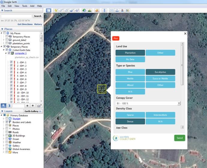


11 Participatory mapping of forest plantations with Open Foris and Google Earth Engine


12 Curricula Co-creative development participatory work workshops with stakeholders joint innovation brainstorming work with stakeholders Problem-solving solutions around real world local needs Embedding these practices into courses, internships and cooperation structures of the universities Skills and competence training User-centred design and prototyping methods bring local contextual knowledge in the innovation process and OS technologies allow their implementation


13 Dissemination Events Different community building efforts invite stakeholders for shared development work and discussion about the future geospatial and ICT possibilities


14 Informal teambuilding Umoja ni nguvu, utengano ni udhaifu
15 The GEO-ICT project improves the quality and societal relevance of geospatial and ICT research and education in four Tanzanian universities

16 tanzania.utu.fi

17 More information: Makame O. Makame Department of Social Sciences State University of Zanzibar Ernest Mauya Department of Forest Operations Management and Techniques Sokoine University of Agriculture Joseph Mayunga Center for Information and Communication Technology Ardhi University Christopher William Department of Geography University of Dar es Salaam Niina Käyhkö Department of Geography and Geology University of Turku, Finland 10/15/2018
Remote Sensing and EO activities at the University of Turku
 Remote Sensing and EO activities at the University of Turku Niina Käyhkö Associate Professor Department of Geography and Geology GEO meeting/syke May 23rd, 2018 Geospatial competence at the University
SCORE. INSPIRE-ing VOLUNTEERED GEOGRAPHIC INFORMATION: CASES FROM SOUTH EAST EUROPE. mashing up community and spatial technology
 mashing up community and spatial technology INSPIRE-ing VOLUNTEERED GEOGRAPHIC INFORMATION: CASES FROM SOUTH EAST EUROPE Spatial Consulting and Research Group integrating geospatial and organizational
ZanSEA capacity building in GIS/EIA on Zanzibar
 SUZAlogo ZanSEA capacity building in GIS/EIA on Zanzibar Impact Assessment in the Digital Era / IAIA15, Florence Presented by Sigurd Juel Kinn, Statoil Classification: Internal Outline of presentation
OPEN FORIS AND GOOGLE EARTH ENGINE LINKING EXPERT PARTICIPATION WITH NATURAL RESOURCE MAPPING AND REMOTE SENSING TRAINING IN TANZANIA
 OPEN FORIS AND GOOGLE EARTH ENGINE LINKING EXPERT PARTICIPATION WITH NATURAL RESOURCE MAPPING AND REMOTE SENSING TRAINING IN TANZANIA Ulpu Leinonen a*, Joni Koskinen a, Harun Makandi b, Ernest Mauya c,
COUNCIL OF THE EUROPEAN UNION. Brussels, 2 May /14 CULT 68
 COUNCIL OF THE EUROPEAN UNION Brussels, 2 May 2014 9129/14 CULT 68 NOTE from: General Secretariat of the Council to: Permanent Representatives Committee (Part 1) / Council No. prev. doc.: 8892/14 CULT
XXIII CONGRESS OF ISPRS RESOLUTIONS
 XXIII CONGRESS OF ISPRS RESOLUTIONS General Resolutions Resolution 0: Thanks to the Czech Society commends: To congratulate The Czech Society, its president and the Congress Director Lena Halounová, the
Creating a Staff Development Plan with Esri
 Creating a Staff Development Plan with Esri Michael Green David Schneider Guest Presenter: Shane Feirer, University of California Esri UC 2014 Technical Workshop Agenda What is a Staff Development Plan?
UN-GGIM: Strengthening Geospatial Capability
 Fifth Plenary Meeting of UN-GGIM: Europe Brussels, 6-7 June 2018 UN-GGIM: Strengthening Geospatial Capability Walking the talk to leave no one behind Greg Scott, UN-GGIM Secretariat Environmental Statistics
Harmonizing spatial databases and services at local and regional level
 Harmonizing spatial databases and services at local and regional level A. Ionita 1, M. Caian 2, V. Vassilev 3, V. Craciunescu 2, I. Nedelcu 4 1 Research Institute for Artificial Intelligence, Bucuresti,
Joanne N. Halls, PhD Dept. of Geography & Geology David Kirk Information Technology Services
 Joanne N. Halls, PhD Dept. of Geography & Geology David Kirk Information Technology Services Geographic Information Systems manage and analyze data to solve spatial problems. Real World Abstraction Analysis
St. Pölten University of Applied Sciences. Strategy St. Pölten University of Applied Sciences. fhstp.ac.at
 St. Pölten University of Applied Sciences Strategy 2021 St. Pölten University of Applied Sciences fhstp.ac.at St. Pölten UAS: My best place Our vision St. Pölten University of Applied Sciences (St. Pölten
GIS and Community Health. GIS and Community Health. Institutional Context and Interests in GIS Development. GIS and Community Health
 GIS and Community Health GIS and Community Health Some critiques of GIS emphasize the potentially harmful social consequences of the diffusion of GIS technology, including reinforcing the power of state
Non-Governmental Organizations for Spatial Data Infrastructure. Environmental Democracy Case
 Non-Governmental Organizations for Spatial Data Infrastructure Environmental Democracy Case L.Jovičić, S.Vrečar, V.Cetl, K.Ristovski GSDI Small Grant Program Award 2011-2012 Non-Governmental Organisations
Esri and GIS Education
 Esri and GIS Education Organizations Esri Users 1,200 National Government Agencies 11,500 States & Regional Agencies 30,800 Cities & Local Governments 32,000 Businesses 8,500 Utilities 12,600 NGOs 11,000
Colin Bray, OSi CEO. Collaboration to develop a data platform for geospatial and statistical information in Ireland
 Colin Bray, OSi CEO Collaboration to develop a data platform for geospatial and statistical information in Ireland Organisations Ireland s National Mapping Agency Established in 1824 Operates under the
Putting the U.S. Geospatial Services Industry On the Map
 Putting the U.S. Geospatial Services Industry On the Map December 2012 Definition of geospatial services and the focus of this economic study Geospatial services Geospatial services industry Allow consumers,
Copernicus Academy. Roles and responsibilities of the Copernicus Academy. user uptake. Focus Data uptake, capacity building and skills development
 Copernicus Academy user uptake Roles and responsibilities of the Copernicus Academy The European Commission has launched two Networks, the Copernicus Relays and the Copernicus Academy, to contribute on
Development of Geospatial Information in Indonesia: Progress & Challenge
 Development of Geospatial Information in Indonesia: Progress & Challenge Dr. Nurwadjedi Sarbini Deputy of Thematic Geospatial Information Geospatial Information Agency (BIG) Geosmart Asia, September 29
Land Use in the context of sustainable, smart and inclusive growth
 Land Use in the context of sustainable, smart and inclusive growth François Salgé Ministry of sustainable development France facilitator EUROGI vice president AFIGéO board member 1 Introduction e-content+
Spatially Enabled Society
 International Seminar on Land Administration Trends and Issues in Asia and the Pacific Region Spatially Enabled Society Abbas Rajabifard Vice Chair PCGIAP-WG3 Vice-President (President Elect), GSDI Association
Information System as a Tool for Marine Spatial Planning The SmartSea Vision and a Prototype
 Information System as a Tool for Marine Spatial Planning The SmartSea Vision and a Prototype Ari Jolma Marine Research Centre Finnish Environment Institute May 10, 2017 ISESS 2017, Zadar, Croatia Contents
Implementing the Sustainable Development Goals: The Role of Geospatial Technology and Innovation
 Fifth High Level Forum on UN Global Geospatial Information Management Implementing the Sustainable Development Goals: The Role of Geospatial Technology and Innovation 28-30 November 2017 Sheraton Maria
CONFERENCE STATEMENT
 CONFERENCE STATEMENT We, the elected representatives from Canada, Denmark/Greenland, Finland, Iceland, Norway, Russia, Sweden and the United States of America; In collaboration with the indigenous peoples
Advancing Geoscientific Capability. Geological Survey of Finland
 Advancing Geoscientific Capability Geological Survey of Finland GTK in brief The Geological Survey of Finland (GTK) is one of the largest European centres of excellence in assessment, research and the
Education in Maritime Spatial Planning European Maritime Days May 22, 2012 Gothenburg
 Education in Maritime Spatial Planning European Maritime Days May 22, 2012 Gothenburg Paula Lindroos, director Baltic Centre for Sustainable Development Uppsala University BUP in Summary A regional university
Voices from Private Sector: Insights for Future NSDI Development in Indonesia
 Voices from Private Sector: Insights for Future NSDI Development in Indonesia Ta n d a n g Yu l i a d i D w i P u t ra, Ryosuke S h i b a s a k i I n st i t u t e o f I n d u st r i a l S c i e n c e,
SCH SCH Agricultural Education General Agriculture , ,359 Leadership
 Oregon State University: Academic Year 2017-18 (Fall 2017, Winter and Spring 2018) Student Credit Hours by College, Department*, Course CIP Code**, and Course Level Office of Institutional Research College
What is special about geospatial? or A discipline in constant transition
 What is special about geospatial? or A discipline in constant transition Marinos Kavouras NTUA Ensuring the Rapid Response to Change, Ensuring the Surveyor of Tomorrow FIG 2015 Several paradigm shifts
SCH SCH Agricultural Education General Agriculture , ,668 Leadership
 Oregon State University: Academic Year 2016-17 (Fall 2016, Winter and Spring 2017) Student Credit Hours by College, Department*, Course CIP Code**, and Course Level Office of Institutional Research College
I N F O P A C K ANIMATE TO PARTICIPATE
 I N F O P A C K ANIMATE TO PARTICIPATE 8-1 7 D E C E M B E R 2 0 1 7 W O R C E S T E R, U K I N F O P A C K A few words about the project F O R W H O M WHAT: Training Course WHEN: 8-17 December 2017 WHERE:
AMS E-GOS Local governance and performance of open data policies at municipal level
 AMS E-GOS Local governance and performance of open data policies at municipal level Frederika Welle Donker Knowledge Centre Open Data TU Delft f.m.welledonker@tudelft.nl 1 Knowledge Centre Open Data Research
Geo Business Gis In The Digital Organization
 We have made it easy for you to find a PDF Ebooks without any digging. And by having access to our ebooks online or by storing it on your computer, you have convenient answers with geo business gis in
A contribution to GEOSS from the SDI for Georesources in Africa
 A contribution to GEOSS from the SDI for Georesources in Africa A. TELLEZ-ARENAS BRGM, France in behalf of: Dr. Marc URVOIS Project Coordinator BRGM, France Mineral Resources Division INSPIRE Conference
Arctic Spatial Data Infrastructure Enabling Access to Arctic Location-Based Information
 Arctic Spatial Data Infrastructure Enabling Access to Arctic Location-Based Information Arctic SDI Side Event Co-Chairs: Arvo Kokkonen Arctic SDI Board Chair & Director General, National Land Survey of
Prof Chryssy Potsiou, FIG President
 THE VALUE OF GEOSPATIAL DATA AND ROLE OF SURVEYORS IN SUSTAINABLE DEVELOPMENT Prof Chryssy Potsiou, FIG President National Technical University of Athens School of Rural and Surveying Engineering, Greece
Esri India User Conference
 Esri India User Conference The Leela Ambience Convention Hotel, Delhi January 19 20, 2017 Keynote Speaker Jack Dangermond Founder and President, Esri Inc. Register Today esriindia.com/indiauc About Esri
Future Proofing the Provision of Geoinformation: Emerging Technologies
 Future Proofing the Provision of Geoinformation: Emerging Technologies An Exchange Forum with the Geospatial Industry William Cartwright Chair JBGIS Second High Level Forum on Global Geospatial Information
Marine Spatial Planning as an important tool for implementing the MSFD
 Marine Spatial Planning as an important tool for implementing the MSFD Risto Kalliola Tallinn, Nov. 16 th 2012 DEPARTMENT OF GEOGRAPHY AND GEOLOGY University of Turku, Finland Ten principles to provide
GIS at UCAR. The evolution of NCAR s GIS Initiative. Olga Wilhelmi ESIG-NCAR Unidata Workshop 24 June, 2003
 GIS at UCAR The evolution of NCAR s GIS Initiative Olga Wilhelmi ESIG-NCAR Unidata Workshop 24 June, 2003 Why GIS? z z z z More questions about various climatological, meteorological, hydrological and
Global Geospatial Information Management Country Report Finland. Submitted by Director General Jarmo Ratia, National Land Survey
 Global Geospatial Information Management Country Report Finland Submitted by Director General Jarmo Ratia, National Land Survey Global Geospatial Information Management Country Report Finland Background
The Integrated Ge spatial Information Framework to the strengthening of NSDI, Mongolia
 Young Geospatial Professionals Summit 21 NOV 2018 The Integrated Ge spatial Information Framework to the strengthening of NSDI, Mongolia BAYARMAA ENKHTUR Geospatial information and technology department
Cartographic and Geospatial Futures
 Cartographic and Geospatial Futures 1. Web Cartography, WebGIS, & Virtual Globes--New Roles for Maps, GIS, and GIS professionals 2. Map Mashups, the Neo Neo-geography Movement, & Crowd-sourcing Geospatial
CK107 BA in Geographical and Archaeological Sciences
 CK107 BA in Geographical and Archaeological Sciences CK107 BA in Geographical and Archaeological Science Geography and Archaeology are closely related disciplines, concerned with concepts of time and space
Economic Benefit Study on Value of Spatial Information Australian Experience
 Economic Benefit Study on Value of Spatial Information Australian Experience Dr Zaffar Sadiq Mohamed-Ghouse Director, International Relations Cooperative Research Centre for Spatial Information zsadiq@crcsi.com.au
Introducing Spatial IQ
 Introducing Spatial IQ TM A Managed Services Approach to Enterprise GIS Let AppGeo be your bridge to the future. The Magic of Location AppGeo believes that information plus geography changes how we work
DEVELOPING FORECASTER COMPETENCES: THE FMI TOPMET PROGRAMME
 DEVELOPING FORECASTER COMPETENCES: THE FMI TOPMET PROGRAMME Tero Siili, Pirkko Pylkkö, Janne Kotro, Anni Simola Finnish Meteorological Institute, PO Box 503, Helsinki, Finland Abstract One of the key education
The Importance of Spatial Literacy
 The Importance of Spatial Literacy Dr. Michael Phoenix GIS Education Consultant Taiwan, 2009 What is Spatial Literacy? Spatial Literacy is the ability to be able to include the spatial dimension in our
Institute of Statistical and Geographical Information of Jalisco State Subnational Statistical and Geographical System India.
 Institute of Statistical and Geographical Information of Jalisco State Subnational Statistical and Geographical System India. January 2017 Subnational Statistical and Geographical System National Statistical
Building Institutional Capacity for Multi-Hazard Early Warning in Pacific Countries Subtitle
 Building Institutional Capacity for Multi-Hazard Early Warning in Pacific Countries Subtitle Title Keran Wang Chief, Space Applications Section ICT and Disaster Risk Reduction Division 30 March 2018 Slide
Strategic considerations for geospatial collection development from Greek Academic Libraries in an open access era: GIS users point of view
 Ifigenia Vardakosta1,2 Sarantos Kapidakis1 1Laboratory on Digital Libraries and Electronic Publishing Department of Archive, Library and Museum Sciences, Faculty of Information Science and Informatics
Evaluating Sustainability of the Georesources Observation System
 Evaluating Sustainability of the Georesources Observation System Michael Mente Federal Institute for Geosciences and Natural Resources Germany, Hannover GEOSS-CBC Meeting Athens April 27th 28th, 2009 GEOSS-CBC
Entrepreneurship on islands and other peripheral regions. Specific Contract No 6511 implementing Framework contract No CDR/DE/16/2015/
 Entrepreneurship on islands and other peripheral regions Specific Contract No 6511 implementing Framework contract No CDR/DE/16/2015/ Aims of this study: To analyse the particular challenges and obstacles
Diffusion of Spatial Data Infrastructures: Private More Inspired than the Public Sector A Case of Tanzania
 Journal of Environmental Science and Engineering B 6 (207) 60-64 doi:0.7265/262-526/207.0.005 D DAVID PUBLISHING Diffusion of Spatial Data Infrastructures: Private More Inspired than the Martine Hagai
BACHELOR OF ARTS GEOGRAPHY
 BACHEL OF ARTS General Education Categories (4-5 credits total) FYS First Year Seminar W-I Written Communication - Level I OC Oral Communication PGR Personal Growth & Responsibility CEA Creative Expression
WHAT YOU WILL LEARN TODAY
 WHAT YOU WILL LEARN TODAY Overview of the new QGIS Academy Curriculum Background on curriculum development Curriculum alignment with national standards Description of the five GIS courses Details of the
Dar es Salaam - Reality Check Workshop
 Dar es Salaam - Reality Check Workshop hosted by GIZ and Dar es Salaam City Council Introduction: Key Urban Characteristics of Dar es Salaam Challenges and Opportunities for Resilient Development in the
Excel Geomatics. Rajesh Paul Excel Geomatics Pvt. Ltd., Noida February, 2015 India Geospatial Forum, Hyderabad
 Excel Geomatics Geo-marketing for Product Sales and Customer Services Rajesh Paul Excel Geomatics Pvt. Ltd., Noida 10-12 February, 2015 India Geospatial Forum, Hyderabad Presentation Outline About Excel
SPLAN-Natura Towards an integrated spatial planning approach for Natura th January, 2017 Brussels. Commissioned by DG Environment
 SPLAN-Natura 2000 Towards an integrated spatial planning approach for Natura 2000 Commissioned by DG Environment 17 th January, 2017 Brussels V. Simeonova (Ph.D.) Drivers towards integrating Biodiversity
Application of WebGIS and VGI for Community Based Resources Inventory. Jihn-Fa Jan Department of Land Economics National Chengchi University
 Application of WebGIS and VGI for Community Based Resources Inventory Jihn-Fa Jan Department of Land Economics National Chengchi University OUTLINE Introduction Methodology Results Conclusions 2 MOTIVATION
Archaeology & Digital Humanities
 WAYNE STATE UNIVERSITY Archaeology & Digital Humanities The D.I.R.T. on Big Data STRENGTHENING THE BIG DATA & ANALYTICS ECOSYSTEM WAYNE STATE UNIVERSITY Krysta Ryzewski Associate Professor of Anthropology
COURSE INTRODUCTION & COURSE OVERVIEW
 week 1 COURSE INTRODUCTION & COURSE OVERVIEW topics of the week Instructor introduction Students introductions Course logistics Course objectives Definition of GIS The story of GIS introductions Who am
Declaration Population and culture
 Declaration Population and culture The ministers of the parties to the Alpine Convention regard the socio-economic and socio-cultural aspects mentioned in Article 2, Paragraph 2, Item a., as being central
GEOGRAPHIC INFORMATION SYSTEMS Session 8
 GEOGRAPHIC INFORMATION SYSTEMS Session 8 Introduction Geography underpins all activities associated with a census Census geography is essential to plan and manage fieldwork as well as to report results
PhD in URBAN PLANNING, DESIGN, AND POLICY - 34th cycle
 PhD in URBAN PLANNING, DESIGN, AND POLICY - 34th cycle Research Field: THE MULTIPLE EFFECTS OF B2C E-COMMERCE GROWTH IN ITALY: RETAIL SYSTEM EVOLUTION AND SPATIAL IMPACT. Monthly net income of PhDscholarship
Rural GIS Applications Geospatial Technology Awareness
 Rural GIS Applications Geospatial Technology Awareness Mike Rudibaugh, Ph.D. Co-PI NSF GeoTech Center Geography/GIS Instructor Lake Land College mrudibau@lakeland.cc.il.us 217-234-5244 What is the GeoTech
WELCOME & INTRODUCTION
 MPA Management Capacity Building Training Module 1: WELCOME & INTRODUCTION Participants Distinguished Guests Welcome Site Overviews of MPAs represented Overview of Training Program What are Today s Objectives?
FIRST-TIME STUDENTS BY PRIMARY MAJOR
 COLLEGE OF ARTS AND SCIENCES Natural Resources and Conservation. 03.0103 Environmental Studies 0 15 7 6 0 0 0 18 0 0 0 0 46 03 Subtotal 0 15 7 6 0 0 0 18 0 0 0 0 46 Area, Ethnic, Cultural, and Gender Studies.
Call for Applications
 Call for Applications for a PanAfGeo Training «WP7 Geoscientific information Management» 20 November - 1 st December 2017 Accra, Ghana in English 1. MAIN CONTEXT OF PANAFGEO PanAfGeo for Pan-African Support
GSDI Global Spatial Data Infrastructure. Convergences between Geo Spatial Communities: key decision for decision making
 GSDI Global Spatial Data Infrastructure Convergences between Geo Spatial Communities: key decision for decision making April 14 th 2010 Bas Kok GSDI Past-President Director of International Affairs, Dutch
UNIVERSITY OF SPATIAL ENGINEERING. PROF. DR. VICTOR JETTEN DRS. TINY LUITEN MBA
 UNIVERSITY OF SPATIAL ENGINEERING. PROF. DR. VICTOR JETTEN DRS. TINY LUITEN MBA 5. PRACTICAL INFO 1. WHY ON EARTH SPATIAL ENGINEERING? 4. WHAT IS THERE AFTER YOU FINISH? 2. WHAT CAN YOU DO? 3. HOW TO BECOME
ANYTIME PDUs: COMBO PACK 4 (62 PDUs) No Longer Available PLAN SUMMARY TAKE COURSES ONLINE 24/7** Purchase Option
 No Longer Available PLAN SUMMARY TAKE COURSES ONLINE 24/7** Purchase Option") ANYTIME PDUs: COMBO PACK 4 (62 PDUs) Purchase Option No Longer Available PLAN SUMMARY The Anytime PDUs: Combo Pack #4 online training subscription plan includes 50 online courses that award a varying number
ANYTIME PDUs: COMBO PACK 4 (62 PDUs) Purchase Option No Longer Available PLAN SUMMARY The Anytime PDUs: Combo Pack #4 online training subscription plan includes 50 online courses that award a varying number
Central Baltic Programme
 Central Baltic Programme 2014-2020 About the Central Baltic Programme 2014-2020 Builds on the Central Baltic INTERREG IV A Programme 2007-2013 Cross-border cooperation projects in the central Baltic Sea
Increasing GI awareness in local authorities in Poland experiences from the INSPIRE Academy training programme
 Increasing GI awareness in local authorities in Poland experiences from the INSPIRE Academy training programme http://www.akademiainspire.pl Maria Andrzejewska, Monika Rusztecka UNEP/GRID-Warsaw Centre,
The use of modern sources of information in shaping the geographic literacy of Russian school students
 Journal of Subject Didactics, 2017 Vol. 2, No. 2, 67-71, DOI: 10.5281/zenodo.1239720 Short Review The use of modern sources of information in shaping the geographic literacy of Russian school students
COUNTY SPATIAL DATA INFRASTRUCTURE PRESENTATION: BY: GEOFREY CHERUIYOT NAIROBI CITY COUNTY
 . COUNTY SPATIAL DATA INFRASTRUCTURE PRESENTATION: BY: GEOFREY CHERUIYOT NAIROBI CITY COUNTY FRAMEWORK FOR AN INTEGRATED SPATIAL DATA INFRASTRUCTURE County GIS GIS : A computer based information system
The B.S.G.E. program is accredited by the Engineering Accreditation Commission of ABET,
 Geomatics Engineering The program of study leading to the Bachelor of Science in Geomatics Engineering (B.S.G.E.) deals with designing solutions to measure, map, model, analyze and graphically display
WHAT YOU WILL LEARN TODAY
 WHAT YOU WILL LEARN TODAY Overview of the new GeoAcademy Curriculum Background on curriculum development Curriculum alignment with national standards Description of the five GIS courses Details of the
Call for papers: "Modelling complex urban environments" specialist conference Sponsored by the Waterloo Institute for Complexity & Innovation (WICI)
") Call for papers: "Modelling complex urban environments" specialist conference Sponsored by the Waterloo Institute for Complexity & Innovation (WICI) June 21-22, 2018, St. Jerome s College, University of
Call for papers: "Modelling complex urban environments" specialist conference Sponsored by the Waterloo Institute for Complexity & Innovation (WICI) June 21-22, 2018, St. Jerome s College, University of
2018 ESRI Education Summit. San Diego. California. Sunday July 8 th 2018 Harper College, Palatine, Illinois, USA Dr. Tong Cheng (Biology), Dr.
, Dr.") 2018 ESRI Education Summit. San Diego. California. Sunday July 8 th 2018 Harper College, Palatine, Illinois, USA Dr. Tong Cheng (Biology), Dr. James Gramlich (Sociology), Mukila Maitha (Geography), Dr.
2018 ESRI Education Summit. San Diego. California. Sunday July 8 th 2018 Harper College, Palatine, Illinois, USA Dr. Tong Cheng (Biology), Dr. James Gramlich (Sociology), Mukila Maitha (Geography), Dr.
BACHELOR OF GEOINFORMATION TECHNOLOGY (NQF Level 7) Programme Aims/Purpose:
 Programme Aims/Purpose:") BACHELOR OF GEOINFORMATION TECHNOLOGY ( Level 7) Programme Aims/Purpose: The Bachelor of Geoinformation Technology aims to provide a skilful and competent labour force for the growing Systems (GIS) industry
BACHELOR OF GEOINFORMATION TECHNOLOGY ( Level 7) Programme Aims/Purpose: The Bachelor of Geoinformation Technology aims to provide a skilful and competent labour force for the growing Systems (GIS) industry
Information Needs & Information Seeking in Internet Era: A Case Study of Geographers in Maharashtra
 International Journal of Research in Library Science ISSN: 2455-104X Indexed in: IIJIF, ijindex, SJIF,ISI Volume 2,Issue 1 (January-June) 2016,99-108 Received: 7 May 2016 ; Accepted: 12 May 2016 ; Published:
ESSENTIAL CONCEPTS AND SKILL SETS OF THE IOWA CORE CURRICULUM
 ESSENTIAL CONCEPTS AND SKILL SETS OF THE IOWA CORE CURRICULUM SOCIAL STUDIES PROVIDED BY THE IOWA DEPARTMENT OF EDUCATION INTRODUCTION Social studies is the integrated study of the social sciences and
Urban Climate Resilience
 Urban Climate Resilience in Southeast Asia Partnership Project Introduction Planning for climate change is a daunting challenge for governments in the Mekong Region. Limited capacity at the municipal level,
Open Source Software Education in Texas
 Open Source Software Education in Texas PHILLIP DAVIS / RICHARD SMITH GEOACADEMY The Challenge for Open Source Adoption OPEN SOURCE Less the 5% of US colleges and universities offer training in Free and
CONTENT. 2 Subject Aims 2. 6 Assessment Strategies 5. 7 Maintaining Standards 5. 9 Annexes 8
 CONTENT Page No Foreword III 1 Introduction 1 1.1 Subject Benchmark statement 1 1.2 Nature and Extent of the Subject 2 2 Subject Aims 2 3 Subject Knowledge and Understanding 3 4 Skills and Attitudes 4
SRI Briefing Note Series No.8 Communicating uncertainty in seasonal and interannual climate forecasts in Europe: organisational needs and preferences
 ISSN 2056-8843 Sustainability Research Institute SCHOOL OF EARTH AND ENVIRONMENT SRI Briefing Note Series No.8 Communicating uncertainty in seasonal and interannual climate forecasts in Europe: organisational
Climate Services for Health Open Geospatial Consortium (OGC) Health Summit Dublin, June 21, 2016
 Health Summit Dublin, June 21, 2016") Climate Services for Health Open Geospatial Consortium (OGC) Health Summit Dublin, June 21, 2016 Dr. Joy Shumake-Guillemot WMO/WHO Climate and Health Office Current and Future Climate Related Health Risks
Climate Services for Health Open Geospatial Consortium (OGC) Health Summit Dublin, June 21, 2016 Dr. Joy Shumake-Guillemot WMO/WHO Climate and Health Office Current and Future Climate Related Health Risks
Marine Spatial Planning Leslie-Ann McGee Battelle Memorial Institute
 Marine Spatial Planning Leslie-Ann McGee Battelle Memorial Institute Rev061708 1 Marine Spatial Planning What is it? Why is it different? Where is it currently being employed? What is happening in the
Demonstration of a local SDI solution with several stakeholders in pilot areas in line with EU best practices
 EU Twinning project for the Agency of Land Relations and Cadaster (ALRC)- Organization, Streamlining and Computerization Process in Mapping in the Republic of Moldova. Demonstration of a local SDI solution
MIDDLE TENNESSEE STATE UNIVERSITY Global Studies / Cultural Geography Major Matrix Page 1 of 7
 Page 1 of 7 I. Social Studies Core GS 4990 (3) Senior Seminar in Global Studies SSC 1. Demonstrate critical thinking in the social sciences by GEOG 2000 (1/3) Introduction to Regional Geography posing
Transforming Chemistry Education through the Green Chemistry Commitment. Amy S. Cannon, Ph.D. Executive Director Beyond Benign
 Transforming Chemistry Education through the Green Chemistry Commitment Amy S. Cannon, Ph.D. Executive Director Beyond Benign Headquarters located in Wilmington, MA Co-founded by John Warner and Amy Cannon
THE ROLE OF SEAMIC IN SUSTAINABLE MINERAL RESOURCES DEVELOPMENT IN AFRICA
 THE ROLE OF SEAMIC IN SUSTAINABLE MINERAL RESOURCES DEVELOPMENT IN AFRICA Ketema Tadesse Director General-SEAMIC Dar es Salaam, Tanzania August 11, 2009 SEAMIC BACKGROUND SEAMIC was established in 1977
PAN AMERICAN INSTITUTE OF GEOGRAPHY AND HISTORY Specialized Organization of the OAS
 PAN AMERICAN INSTITUTE OF GEOGRAPHY AND HISTORY Specialized Organization of the OAS 10 th UNRCC Americas United Nations, New York, 20 August 2013 PAIGH, SIRGAS, PC-IDEA and GeoSUR 2013-2015 Joint Action
Karl Donert, President EUROGEO, Director: European Centre of Excellence: digital-earth.eu. Derby, Saturday 6 April 2013
 Karl Donert, President EUROGEO, eurogeomail@yahoo.co.uk Director: European Centre of Excellence: digital-earth.eu Derby, Saturday 6 April 2013 European Association of Geographers Legally based in Belgium
Pathways. Pathways through the Geography Major
 Pathways through the Major majors may structure their course selections around a sub-field of. Pathways are suggestions for classes in, in related disciplines, and skills training. Each pathway includes
Proposal for Revision to the Geographic Information Systems (GIS) Academic Certificate Community College of Philadelphia.
 Academic Certificate Community College of Philadelphia.") Proposal for Revision to the Geographic Information Systems (GIS) Academic Certificate Community College of Philadelphia February 24, 2010 Kathy Smith Chair, Social Science Contributors Christopher Murphy
Proposal for Revision to the Geographic Information Systems (GIS) Academic Certificate Community College of Philadelphia February 24, 2010 Kathy Smith Chair, Social Science Contributors Christopher Murphy
Status of implementation of the INSPIRE Directive 2016 Country Fiches. COUNTRY FICHE Finland
 Status of implementation of the INSPIRE Directive 2016 Country Fiches COUNTRY FICHE Finland Introduction... 1 1. State of Play... 2 1.1 Coordination... 2 1.2 Functioning and coordination of the infrastructure...
GIS Building Communities beyond National Borders (Building Successful Spatial Data Infrastructures) Nick Land, ESRI Europe
 Nick Land, ESRI Europe") GIS Building Communities beyond National Borders (Building Successful Spatial Data Infrastructures) Nick Land, ESRI Europe UK worst flooding in the last 60 years 350,000 households without drinking water
GIS Building Communities beyond National Borders (Building Successful Spatial Data Infrastructures) Nick Land, ESRI Europe UK worst flooding in the last 60 years 350,000 households without drinking water
Basic Act on the Advancement of Utilizing Geospatial Information
 Basic Act on the Advancement of Utilizing Geospatial Information (Act No. 63 of May 30, 2007) Table of Contents Chapter I General Provisions (Articles 1 to 8) Chapter II Basic Plan for the Advancement
Concept Formulation of Geospatial Infrastructure. Hidenori FUJIMURA*
 Concept Formulation of Geospatial Infrastructure 1 Concept Formulation of Geospatial Infrastructure Hidenori FUJIMURA* (Published online: 28 December 2016) Abstract Technical trends in the field of surveying