Karl Donert, President EUROGEO, Director: European Centre of Excellence: digital-earth.eu. Derby, Saturday 6 April 2013
|
|
|
- Alexander Lindsey
- 6 years ago
- Views:
Transcription


1 Karl Donert, President EUROGEO, Director: European Centre of Excellence: digital-earth.eu Derby, Saturday 6 April 2013
 Network for higher education in")
2 European Association of Geographers Legally based in Belgium International NGO established 1976 by the European Commission to network geographers A professional association for geographers, geo -scientists and related areas Developed from the HERODOT (Bologna Process) Network for higher education in Europe


3 Participatory status: the only Geo-NGO Culture, Education, Environment groups Lobbying in the European Parliament Attendance at major meetings EUROGEO Secretary General elected Vice President of Education group

 on Thursday afternoon (limited")
4 EUROGEO 2013: Geography - linking tradition and future 8-11 May 2013 Venue: Brugge, Belgium, Sint-Lodewijkscollege Program: conference sessions keynote speakers field trip witness unique Holy Blood Procession (UNESCO) on Thursday afternoon (limited seats reserved)

5 Visit to find out more
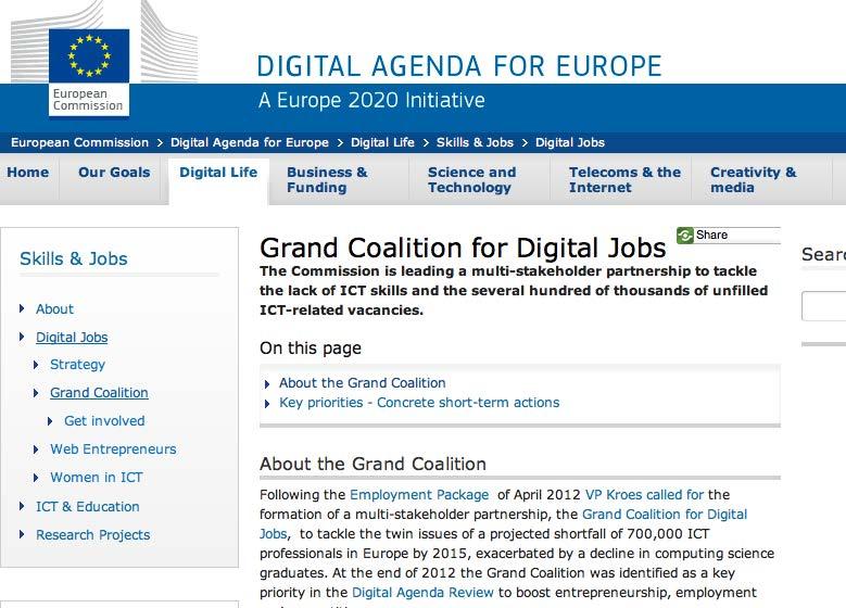
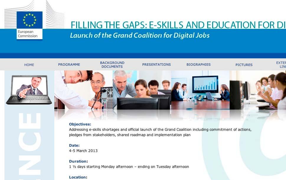
6 European societal challenges CORINE (Coordination of Information on the Environment) project Global Monitoring for Environment and Security' (GMES) 2004 INSPIRE Directive Open governance new opportunities for citizens to interact Open data freedom of information (Neelie Kroes, 2011; 2012) Europe Education & Training 2020
 project Global Monitoring for Environment and Security' (GMES) 2004")
 Europe 2020 - Education")
7 European societal challenges CORINE (Coordination of Information on the Environment) project Global Monitoring for Environment and Security' (GMES) 2004 INSPIRE Directive Open governance new opportunities for citizens to interact Open data freedom of information (Neelie Kroes, 2011; 2012) Europe Education & Training 2020

8 Should provide political and economic decision-takers and scientists with reliable data for assessing environmental conditions across the whole of Europe UK - IT - FR Dutch government released core data sets to the public free of charge for re-use, from January 1 st 2012 NL - Finnish government opened up all its data for free re -use from May 1 st 2012 Estonia, Iceland.. soon other countries? Regions?

9 Europeana
10

11


12 Capacity for change: sustainable implementation and progressive scaling up (of ICT-enabled innovative learning environments) EC Joint Research Centre (2012)

13 JRC (2012) "Challenges of implementing Creative Classrooms practices, pages/eap/documents/_6_etwinning_ws1_march2012.pdf, etwinning conference, Tampere Finland

14


15 Personal Learning Environments - Jeremy Hiebert (2006) collecting reflecting connecting publishing Hiebert J (2006), Personal Learning Environment, HeadsPaceJ, /02/personal-learning-environment-model.html 1 5

16
17 Norman, D. A. (1998). The invisible computer: Why Good Products Can Fail, the Personal Computer Is So Complex, and Information Appliances Are the Solution. Cambridge, MA: MIT Press.


18 Visionary engineering-genius, Buckminster Fuller GeoScope Articulated in 1992 by former US VP Al Gore
 to become spatial citizens (Vogler et al., 2012) Golledge, R., Marsh, M., and Battersby, S., 2008.")
19 Digital Earth is about geographic media (Gryl et al., 2010) Media with a strong spatial-temporal component What competences are needed? Spatial thinking is essential to learning about the world we live in (Golledge et al. 2008) to become spatial citizens (Vogler et al., 2012) Golledge, R., Marsh, M., and Battersby, S., A conceptual framework for facilitating geospatial thinking. Annals of the Association of American Geographers, 98 (2), Gryl I, Jekel T and Donert K (2010), Spatial Citizenship, p2-12, In Jekel T, Donert K and Koller A (eds.) Learning with GeoInformation V, Berlin, Wichman Verlag Vogler R, Henning S, Jekel T and Donert K (2012), Towards a concept of Spatially-enabled learning, : In Jekel T, Car A, Strobl J and Griesbner M, (eds.) Geovisualisation, Society and Learning, Berlin, Wichman Verlag
20 Spatial Citizen (based on Strobl 2008:134) Education for Spatial Citizenship (Gryl, Jekel and Donert, 2010) Strobl, J. ( ) Geospatial Qualifications: Schools, Citizens and Professionals. Vortrag: GI-Forum 2008 (Salzburg University, Z_GIS Centre for Geoinformatics), Salzburg/Austria. Donert K, Gryl I and Jekel T (2010), GI & Spatial Citizenship, In Jekel T, Donert K, Koller A and Vogler R, Learning with GeoInformation V, Berlin, Wichman Verlag 2 0
21 Spatial Citizen (based on Strobl 2008:134) Transformative Education for Spatial Citizenship participative making a difference (Gryl, Jekel and Donert, 2010) Taking control gaining power (Facebook revolution) Strobl, J. ( ) Geospatial Qualifications: Schools, Citizens and Professionals. Vortrag: GI-Forum 2008 (Salzburg University, Z_GIS Centre for Geoinformatics), Salzburg/Austria. Donert K, Gryl I and Jekel T (2010), GI & Spatial Citizenship, In Jekel T, Donert K, Koller A and Vogler R, Learning with GeoInformation V, Berlin, Wichman Verlag 2 1
22 Spatial Citizenship Donert K, Gryl I and Jekel T (2010), GI & Spatial Citizenship, In Jekel T, Donert K, Koller A and Vogler R, Learning with GeoInformation V, Berlin, Wichman Verlag 22

23 Spatial Citizenship Donert K, Gryl I and Jekel T (2010), GI & Spatial Citizenship, In Jekel T, Donert K, Koller A and Vogler R, Learning with GeoInformation V, Berlin, Wichman Verlag 2 3
24 Spatial Citizenship Donert K, Gryl I and Jekel T (2010), GI & Spatial Citizenship, In Jekel T, Donert K, Koller A and Vogler R, Learning with GeoInformation V, Berlin, Wichman Verlag 2 4


25 Spatial Citizenship


26 Spatial Citizenship Deconstruct images, media, data and maps


27 Spatial Citizenship Deconstruct imagery, media, data and maps


28 Spatial Citizenship Deconstruct imagery, media data and maps
29 to KNOW about the construction of geo-media to RECOGNISE its construction to COMPARE the perspective of certain geo-media with external information and previous knowledge to IDENTIFY the intentionality of the use of geo -media in discourses, by reflection from multiple perspectives with the help of DECONSTRUCTION 2 9

30 to KNOW about the construction of geo-media to RECOGNISE its construction to COMPARE the perspective of certain geo-media with external information and previous knowledge to IDENTIFY the intentionality of the use of geo -media in discourses, by reflection from multiple perspectives with the help of DECONSTRUCTION 3 0
31 Spatial Citizenship Donert K, Gryl I and Jekel T (2010), GI & Spatial Citizenship, In Jekel T, Donert K, Koller A and Vogler R, Learning with GeoInformation V, Berlin, Wichman Verlag 3 1
 Gryl I, Jekel T Donert K (2010), GI & Spatial Citizenship, In Jekel T, Donert K and Koller A, Learning with GeoInformation V,")
32 to FORMULATE alternative spatial scenarios to NEGOTIATE alternative scenarios (with respect to different interests in democratic decision making processes) to COMMUNICATE alternative meanings with geomedia eg Counter Mapping and neo -geography (Harris et al, 2006) Gryl I, Jekel T Donert K (2010), GI & Spatial Citizenship, In Jekel T, Donert K and Koller A, Learning with GeoInformation V, Berlin, Wichman Verlag Harris, L., & Hazen, H. D. (2006). Power of maps:(counter) mapping for conservation. ACME: An international e-journal for critical geographies, 4(1),


33 Community action Engaging framework


34 Constructivist we all actively construct their citizenship stresses active participation and interaction Intercultural diversity in ideas, values and behaviours Built on dialogue negotiation communication - the appropriation of space empowerment to participate in the debate about the sort of future society we need to create Technological digital geo-literacy and the citizen Donert K (2008), Examining the relationship between Citizenship and Geography Education, 73-92, in Lambrinos N and Reliou M (Eds.), European Geography Education: the challenges of a new era, Arlington, W Virginia, National Council for Geographic Education
35
36
37


38 Infrastructure issues: soft- hardware, Low knowledge of teachers, low confidence No time in the curriculum, curriculum too full Not in teacher training curriculum Decision makers unaware of importance No guidelines what students should be able to do (Needs Analysis, digital-earth.eu Project, 2011) Need Not 1: many support teachers for grassroots involved actors Need 2: target key decision makers politicians (EU /national), Ministries, ICT coordinators, curriculum developers, geospatial industry etc. Too few young people with the necessary awareness, skills, knowledge and experience

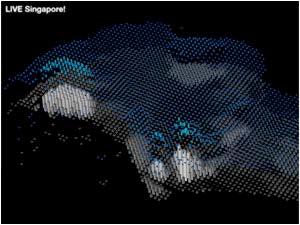
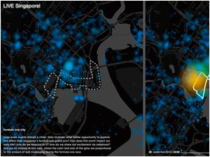
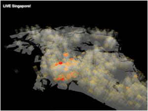
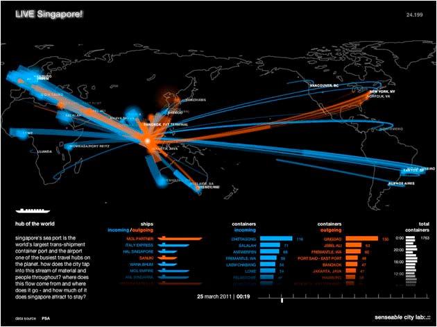
media spatial citizenship Becoming")
39 Digital-earth.eu Project outcomes so far Introduced new education concepts geographic (geo-)media spatial citizenship Becoming accepted (by researchers, educators.)

40 Digital-earth.eu Project outcomes so far Centres of Excellence definition strategic assets. to press the case for and manage complex change initiatives in a specific field sustainable entity, continue beyond funding provide leadership inform / influence decision makers develop / deliver services to stakeholders carry out education activities

41 Integrating Digital Earth in the Digital Agenda for Europe

42 Digital-earth.eu Project outcomes so far


43 Digital-earth.eu Project outcomes so far Geo-services: connecting to resources for education


44 Digital-earth.eu Project achievements so far Lobbying Parliamentarians Civil Servants Ministries of Education Council of Europe European Commission Commissioners European Environment Agency Industry
")

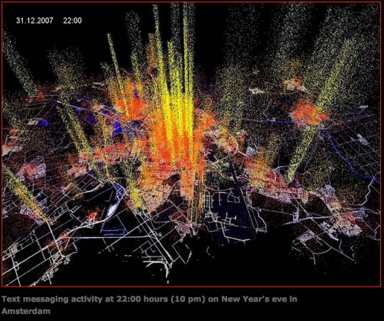
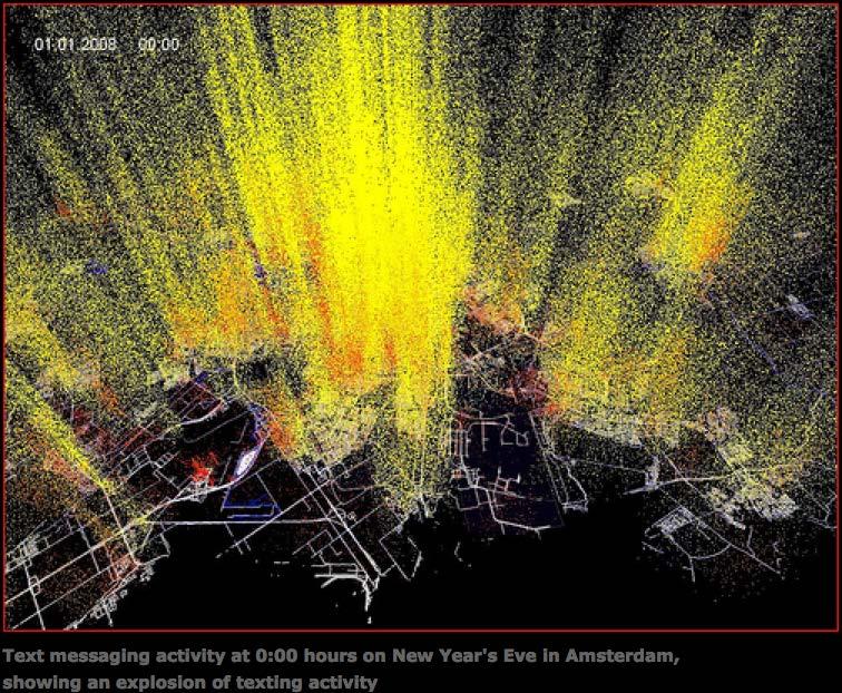
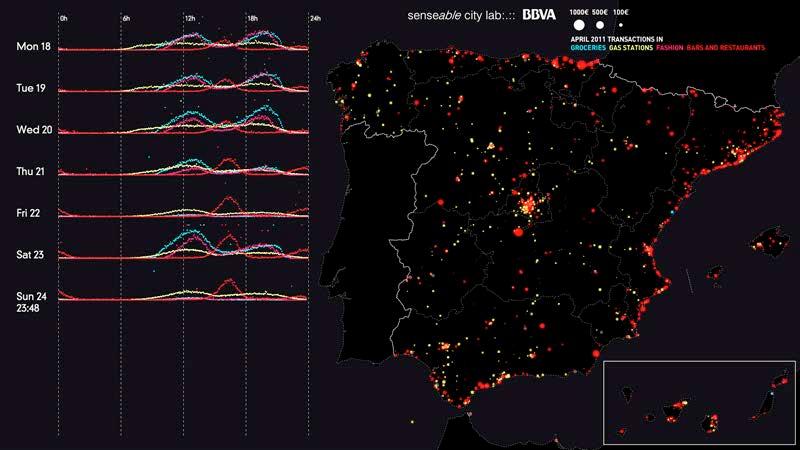
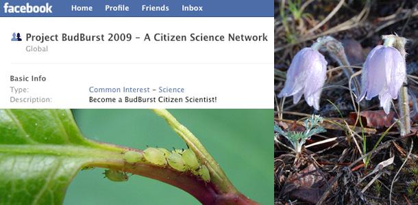
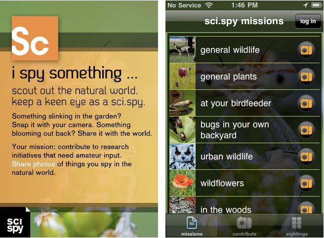
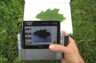
45 Live real-time maps / visualisations / crisis response User-generated content (prosumers) Volunteered geographic information Unvolunteered GI Crowdsourcing Citizen Science Internet of things

46 Volunteered Geographic information

47

48

49 Each producer creates maps and publishes services and metadata when they want Can publish and reference own maps and services in their blog, web site, social networking Can re-use one another s available layers, including backgrounds / base maps
50 Big data Unvolunteered information Ethical issues Geo-tagged information

51

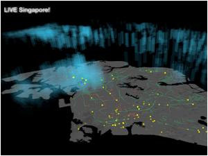
52 Live Singapore traffic isochrones, raining taxis, heat island, Formula 1, real-time talk, hub of the world

53 Live Singapore Real-time visualisations of Singapore, now an exhibition showing the potential of geo-information
54
55
56
57

58

59
60
61
62

63

64

65

66

67
 Lives")
. Learning to Think Spatially. Washington D.C.")
68 Advanced technological landscape evolved Large organisations getting information into the hands of billions of citizens Estimated 70-80% has a spatial component (Downs and DeSouza 2006) Lives inundated with spatial information People finding many uses Flickr, Twitter, Facebook and Wikimapia Downs, R. and A. DeSouza (2006). Learning to Think Spatially. Washington D.C., National Academies Press.

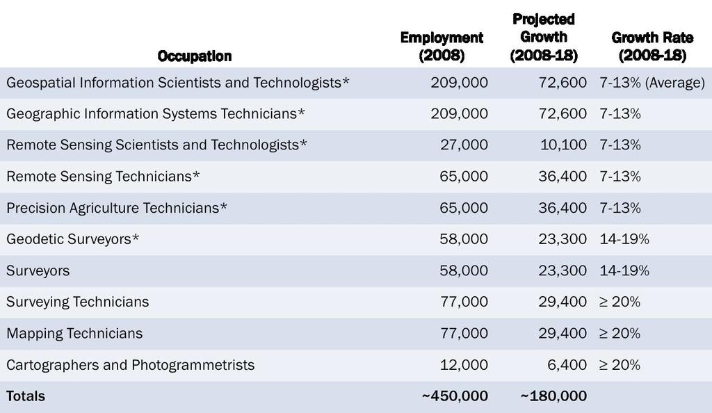

69 No defined geospatial workforce USA data:


70 Huge scientific movement Technology available Exceptionally rich opportunity Not yet expressed in geography education ArcGIS Online Real-time maps digital-earth-real-time-maps2.html
71 Education for Digital Earth will help us understand our earth system A unique set of (geo-)skills needed to successfully navigate our world Convince education stakeholders Visit for more information and how to participate

72 Karl Donert @karldonert
Karl Donert, President EUROGEO, Director: European Centre of Excellence. Zaragoza, Spain: November 2012
 Karl Donert, President EUROGEO, Director: European Centre of Excellence Zaragoza, Spain: 22-24 November 2012 European Association of Geographers Legally based in Belgium International NGO established 1976
COUNCIL OF THE EUROPEAN UNION. Brussels, 2 May /14 CULT 68
 COUNCIL OF THE EUROPEAN UNION Brussels, 2 May 2014 9129/14 CULT 68 NOTE from: General Secretariat of the Council to: Permanent Representatives Committee (Part 1) / Council No. prev. doc.: 8892/14 CULT
ESSENTIAL CONCEPTS AND SKILL SETS OF THE IOWA CORE CURRICULUM
 ESSENTIAL CONCEPTS AND SKILL SETS OF THE IOWA CORE CURRICULUM SOCIAL STUDIES PROVIDED BY THE IOWA DEPARTMENT OF EDUCATION INTRODUCTION Social studies is the integrated study of the social sciences and
Geography. Programme of study for key stage 3 and attainment target (This is an extract from The National Curriculum 2007)
") Geography Programme of study for key stage 3 and attainment target (This is an extract from The National Curriculum 2007) Crown copyright 2007 Qualifications and Curriculum Authority 2007 Curriculum aims
Geography Programme of study for key stage 3 and attainment target (This is an extract from The National Curriculum 2007) Crown copyright 2007 Qualifications and Curriculum Authority 2007 Curriculum aims
Implementing the Sustainable Development Goals: The Role of Geospatial Technology and Innovation
 Fifth High Level Forum on UN Global Geospatial Information Management Implementing the Sustainable Development Goals: The Role of Geospatial Technology and Innovation 28-30 November 2017 Sheraton Maria
KUNMING FORUM ON UNITED NATIONS GLOBAL GEOSPATIAL INFORMATION MANAGEMENT CITIES OF THE FUTURE: SMART, RESILIENT
 KUNMING FORUM ON UNITED NATIONS GLOBAL GEOSPATIAL INFORMATION MANAGEMENT CITIES OF THE FUTURE: SMART, RESILIENT and SUSTAINABLE Yunnan Zhenzhuang Guest House, Kunming, China 10 12 May 2017 BACKGROUND CONCEPT
Quality information for the Digital Agenda EuroGeographics contribution to the Digital Agenda for Europe
 Quality information for the Digital Agenda EuroGeographics contribution to the Digital Agenda for Europe Ingrid Vanden Berghe, EuroGeographics President high performance infrastructure quality contentinformation
GSDI Global Spatial Data Infrastructure. Convergences between Geo Spatial Communities: key decision for decision making
 GSDI Global Spatial Data Infrastructure Convergences between Geo Spatial Communities: key decision for decision making April 14 th 2010 Bas Kok GSDI Past-President Director of International Affairs, Dutch
The Purpose of the Charter on Geographical Education
 2016 International Charter on Geographical Education Contents Purpose of the Charter on Geographical Education... 1 The Contribution of Geography to Education 3 Research in Geographical Education... 3
Land Use in the context of sustainable, smart and inclusive growth
 Land Use in the context of sustainable, smart and inclusive growth François Salgé Ministry of sustainable development France facilitator EUROGI vice president AFIGéO board member 1 Introduction e-content+
European geography and what it can do for the future: the case of a bi-communal project in divided Cyprus
 European geography and what it can do for the future: the case of a bi-communal project in divided Cyprus Stavroula Philippou Assistant Professor (Curriculum & Instruction) Department of Education Sciences
GIS and Community Health. GIS and Community Health. Institutional Context and Interests in GIS Development. GIS and Community Health
 GIS and Community Health GIS and Community Health Some critiques of GIS emphasize the potentially harmful social consequences of the diffusion of GIS technology, including reinforcing the power of state
CONFERENCE STATEMENT
 CONFERENCE STATEMENT We, the elected representatives from Canada, Denmark/Greenland, Finland, Iceland, Norway, Russia, Sweden and the United States of America; In collaboration with the indigenous peoples
Esri and GIS Education
 Esri and GIS Education Organizations Esri Users 1,200 National Government Agencies 11,500 States & Regional Agencies 30,800 Cities & Local Governments 32,000 Businesses 8,500 Utilities 12,600 NGOs 11,000
Spatially Enabled Society
 International Seminar on Land Administration Trends and Issues in Asia and the Pacific Region Spatially Enabled Society Abbas Rajabifard Vice Chair PCGIAP-WG3 Vice-President (President Elect), GSDI Association
Web 2.0, map production & publishing and geospatial information dissemenation
 Web 2.0, map production & publishing and geospatial information dissemenation Professor William Cartwright President, International Cartographic Association William Cartwright 18th UNRCC for Asia and the
Curriculum and Assessment in Geography at KS3
 Curriculum and Assessment in Geography at KS3 Curriculum Statement: Geography The world as we know it is not given and it can and it will change. - Lambert et al. Powerful Knowledge in Geography Geography
Diverse Places 3 days
 AS Level Geography Edexcel Diverse Places 3 days Deliver two days of fieldwork within a dynamic human environment and cover the recommended themes in depth. Fieldwork in these locations provides a contrast
Understanding the Spatial Effects of High Speed Rail
 Transport and Spatial Planning Transport Planning Society and RTPI 23 November 2015 Finsbury Square, London Understanding the Spatial Effects of High Speed Rail Professor John Worthington Commissioner,
Urban Climate Resilience
 Urban Climate Resilience in Southeast Asia Partnership Project Introduction Planning for climate change is a daunting challenge for governments in the Mekong Region. Limited capacity at the municipal level,
The Relevance of Cartography. Dubai 2015, Georg Gartner
 The Relevance of Cartography Dubai 2015, Georg Gartner Where are we? Data! Data? We are not short of data Technologies! Technologies? We are not short of technologies Data-driven and technology-driven
PUBLIC HEALTH ASSOCIATION OF AUSTRALIA Strategic Plan
 PUBLIC HEALTH ASSOCIATION OF AUSTRALIA Strategic Plan March 2017 20 Napier Close Deakin ACT Australia 2600 PO Box 319 Curtin ACT Australia 2605 Table of Contents Introduction... 2 Vision for a healthy
INSPIRE Basics. Vlado Cetl European Commission Joint Research Centre. https://ec.europa.eu/jrc/
 INSPIRE Basics Vlado Cetl European Commission Joint Research Centre https://ec.europa.eu/jrc/ Serving society Stimulating innovation Supporting legislation Outline SDI? Why European SDI? INSPIRE Policy
Roadmap to interoperability of geoinformation
 Roadmap to interoperability of geoinformation and services in Europe Paul Smits, Alessandro Annoni European Commission Joint Research Centre Institute for Environment and Sustainability paul.smits@jrc.it
2016 International Charter on. Geographical Education
 2016 International Charter on Geographical Education IGU UGI Commission on CGE Geographical Education Contents 1 The Proclamation 4 Affirmations 4 The Contribution of Geography to Education 5 Research
IHO STAKEHOLDERS FORUM. Hydrographic data and its role in MSDI. Thursday 27 September Jens Peter Hartmann KMS
 IHO STAKEHOLDERS FORUM Hydrographic data and its role in MSDI Thursday 27 September Jens Peter Hartmann KMS Agenda Traditional approach to hydrographic data Expectations within the marine / maritime field
Building capacity for gender responsive planning and budgeting, the Mozambican experience
 UNIVERSIDADE EDUARDO MONDLANE Building capacity for gender responsive planning and budgeting, the Mozambican experience Generosa Cossa José Director, Centre for Coordination of Gender Issues Eduardo Mondlane
Geospatial information in e-government services for environmental permiting the eenviper project case study
 UDC: 007:528.9]:004; 007:912]:004; 004.92 DOI:10.14438/gn.2013.20 Geospatial information in e-government services for environmental permiting the eenviper project case study Dragutin PROTIĆ 1*, Ivan NESTOROV
Analys av GIS-användning inom offentlig sektor i Norden
 Analys av GIS-användning inom offentlig sektor i Norden Henning Sten Hansen, Line Hvingel and Lise Schrøder Aalborg Universitet Jönköping, Sweden 30 March 2011 Overview The Danish and Swedish approaches
FIG Asia Pacific Capacity Development Network
 FIG Asia Pacific Capacity Development Network Report to the 41th General Assembly FIG Congress 2018, Istanbul - Turkey Rob Sarib Chair FIG Asia Pacific Capacity Development Network (AP CDN) Story of the
Copernicus Academy. Roles and responsibilities of the Copernicus Academy. user uptake. Focus Data uptake, capacity building and skills development
 Copernicus Academy user uptake Roles and responsibilities of the Copernicus Academy The European Commission has launched two Networks, the Copernicus Relays and the Copernicus Academy, to contribute on
Esri India User Conference
 Esri India User Conference The Leela Ambience Convention Hotel, Delhi January 19 20, 2017 Keynote Speaker Jack Dangermond Founder and President, Esri Inc. Register Today esriindia.com/indiauc About Esri
Seymour Centre 2017 Education Program 2071 CURRICULUM LINKS
 Suitable for: Stage 5 Stage 6 HSC Subject Links: Seymour Centre 2017 Education Program 2071 CURRICULUM LINKS Science Stage Content Objective Outcomes Stage 5 Earth and Space ES3: People use scientific
BACK TO SCHO O L W ITH
 Your web browser (Safari 7) is out of date. For more security, comfort and the best experience on this site: Update your browser Ignore BACK TO SCHO O L W ITH GEO - L ITERACY Essays on Geo-Literacy For
Smart Citizens. Maria Antonia Brovelli Politecnico di Milano, Italy
 Smart Citizens Maria Antonia Brovelli Politecnico di Milano, Italy UN-GGIM Academic Network Forum Secure Land Rights and Smart Cities: Making It Work for Sustainable Development New York, 31 July 2017
St John s Catholic Primary School. Geography Policy. Mission Statement
 St John s Catholic Primary School Geography Policy Mission Statement We at St John s strive for excellence in education by providing a safe, secure and caring family environment where individuals are valued
Dublin City Schools Social Studies Graded Course of Study Grade 5 K-12 Social Studies Vision
 K-12 Social Studies Vision The Dublin City Schools K-12 Social Studies Education will provide many learning opportunities that will help students to: develop thinking as educated citizens who seek to understand
Open Cities Project. The World Bank, South Asia Region. Background
 Open Cities Project The World Bank, South Asia Region Opencitiesproject.com Background The World Bank s South Asia Region (SAR) is proud to announce its new Open Cities Project. The goal of this project
REGIONAL SDI DEVELOPMENT
 REGIONAL SDI DEVELOPMENT Abbas Rajabifard 1 and Ian P. Williamson 2 1 Deputy Director and Senior Research Fellow Email: abbas.r@unimelb.edu.au 2 Director, Professor of Surveying and Land Information, Email:
Economic and Social Council
 United Nations Economic and Social Council Distr.: General 18 July 2016 Original: English Committee of Experts on Global Geospatial Information Management Sixth session New York, 3-5 August 2016 Item 2
Crowdsourcing, Citizen Science & INSPIRE
 Crowdsourcing, Citizen Science & INSPIRE Muki Haklay & Claire Ellul Extreme Citizen Science (ExCiteS) research group, UCL @mhaklay / @UCL_ExCiteS Outline Three eras of environmental information: By experts,
Belfairs Academy GEOGRAPHY Fundamentals Map
 YEAR 12 Fundamentals Unit 1 Contemporary Urban Places Urbanisation Urbanisation and its importance in human affairs. Global patterns of urbanisation since 1945. Urbanisation, suburbanisation, counter-urbanisation,
Cooperation is the key, FIG can facilitate
 Cooperation is the key, FIG can facilitate Mikael Lilje Vice President 2017-2020 Head, Geodetic infrastructure, Swedish mapping, cadastral and land registration authority Presented at the GIS/RS Conference
Arctic Spatial Data Infrastructure Enabling Access to Arctic Location-Based Information
 Arctic Spatial Data Infrastructure Enabling Access to Arctic Location-Based Information Arctic SDI Side Event Co-Chairs: Arvo Kokkonen Arctic SDI Board Chair & Director General, National Land Survey of
Challenges in the Human Environment 3 days
 GCSE Geography AQA Challenges in the Human Environment 3 days In-depth coverage of fieldwork within an urban environment, required for 3.3.2 Section B: Fieldwork, enabling students to get the grades they
Summary of Global Mapping Forum 2003 in Okinawa and its Outcomes
 Summary of Global Mapping Forum 2003 in Okinawa and its Outcomes 1 Summary of Global Mapping Forum 2003 in Okinawa and its Outcomes Hidetoshi NAKAJIMA Abstract Global Mapping Forum 2003 in Okinawa was
AMS E-GOS Local governance and performance of open data policies at municipal level
 AMS E-GOS Local governance and performance of open data policies at municipal level Frederika Welle Donker Knowledge Centre Open Data TU Delft f.m.welledonker@tudelft.nl 1 Knowledge Centre Open Data Research
BUILDING GEOSPATIAL COMPETENCES IN TANZANIAN UNIVERSITIES WITH
 BUILDING GEOSPATIAL COMPETENCES IN TANZANIAN UNIVERSITIES WITH OPEN SOURCE SOLUTIONS N. Käyhkö, C. William, J. Mayunga, M.O. Makame, E. Mauya, A. Järvi a b c d e a) University of Turku (UTU), Department
Data journalism training on
 Data journalism training on 7 th April 2016 International Festival of Journalism Perugia, Italy Caterina F. Guidi and Laura Bartolini Research Associates - GlobalStat RSCAS, European University Institute
CONFERENCE STATEMENT
 Final draft CONFERENCE STATEMENT We, the elected representatives of Canada, Denmark/Greenland, the European Parliament, Finland, Iceland, Norway, Russia, Sweden and the United States of America; In collaboration
2018/1 The integration of statistical and geospatial information. The Regional Committee of UN-GGIM: Americas:
 The following are the conclusions and recommendations of the Regional Committee of the United Nations on Global Geospatial Information Management for the Americas, during its Fifth Session, Thursday 8
The future of SDIs. Ian Masser
 The future of SDIs Ian Masser Presentation Considers two questions relating to the future development of SDIs throughout the world Where have we got to now? Where should we go from here? Identifies four
Towards a City Model for Heritage-Led Regeneration and Tourism Development
 Towards a City Model for Heritage-Led Regeneration and Tourism Development Brian Smith, Secretary General European Association of Historic Towns and Regions Summary of Presentation Objective Background
Geospatial Information and Sustainable Development (Rio+20) A Belgian perspective
 A Belgian perspective") Geospatial Information and Sustainable Development (Rio+20) A Belgian perspective In the resolution adopted by the General Assembly, The future we want World leaders acknowledged the need to further mainstream
Geospatial Information and Sustainable Development (Rio+20) A Belgian perspective In the resolution adopted by the General Assembly, The future we want World leaders acknowledged the need to further mainstream
Statement (India) at the 1 st High Level Forum Meeting of United Nations Global Geospatial Information Management held at Seoul on 24 th October 2011
 at the 1 st High Level Forum Meeting of United Nations Global Geospatial Information Management held at Seoul on 24 th October 2011") Statement (India) at the 1 st High Level Forum Meeting of United Nations Global Geospatial Information Management held at Seoul on 24 th October 2011 T Ramasami, Secretary to The Government of India, Ministry
Statement (India) at the 1 st High Level Forum Meeting of United Nations Global Geospatial Information Management held at Seoul on 24 th October 2011 T Ramasami, Secretary to The Government of India, Ministry
The ESPON Programme. Goals Main Results Future
 The ESPON Programme Goals Main Results Future Structure 1. Goals Objectives and expectations Participation, organisation and networking Themes addressed in the applied research undertaken in ESPON projects
Open spatial data infrastructure
 Open spatial data infrastructure a backbone for digital government Thorben Hansen Geomatikkdagene 2018 Stavanger 13.-15. mars Spatial Data Infrastructure definition the technology, policies, standards,
Colin Bray, OSi CEO. Collaboration to develop a data platform for geospatial and statistical information in Ireland
 Colin Bray, OSi CEO Collaboration to develop a data platform for geospatial and statistical information in Ireland Organisations Ireland s National Mapping Agency Established in 1824 Operates under the
International Year of Chemistry 2011 Improving together the image of the Chemical Industry and SusChem
 International Year of Chemistry 2011 Improving together the image of the Chemical Industry and SusChem Daniel Verbist Executive Director Build Trust and Coms 3 March 2010 1 Plant safety: Bhopal, Seveso
XXIII CONGRESS OF ISPRS RESOLUTIONS
 XXIII CONGRESS OF ISPRS RESOLUTIONS General Resolutions Resolution 0: Thanks to the Czech Society commends: To congratulate The Czech Society, its president and the Congress Director Lena Halounová, the
The Council of Europe Spatial/ Regional Planning (CEMAT) considering Landscape with its Heritage Values
 considering Landscape with its Heritage Values") The Council of Europe Spatial/ Regional Planning (CEMAT) considering Landscape with its Heritage Values Report to The Council of Europe Directorate of Culture and Cultural and Natural Heritage 30 April
The Council of Europe Spatial/ Regional Planning (CEMAT) considering Landscape with its Heritage Values Report to The Council of Europe Directorate of Culture and Cultural and Natural Heritage 30 April
The Integrated Ge spatial Information Framework to the strengthening of NSDI, Mongolia
 Young Geospatial Professionals Summit 21 NOV 2018 The Integrated Ge spatial Information Framework to the strengthening of NSDI, Mongolia BAYARMAA ENKHTUR Geospatial information and technology department
UN Resolution on GGRF ( and its implementation in Europe)
") Presented at the FIG Working Week 2017, UN Resolution on GGRF ( and its implementation in Europe) May 29 - June 2, 2017 in Helsinki, Finland Markku Poutanen, FGI Contents Global Geodetic Reference Frame
Presented at the FIG Working Week 2017, UN Resolution on GGRF ( and its implementation in Europe) May 29 - June 2, 2017 in Helsinki, Finland Markku Poutanen, FGI Contents Global Geodetic Reference Frame
UNESCO World Heritage Centre - Arab States Unit
 UNESCO World Heritage Centre - Arab States Unit Post-Conflict Reconstruction in the Middle East Context and in the Old City of Aleppo in Particular UNESCO Headquarter, 18-19 June 2015 ACTION PLAN resulting
Economic and Social Council
 United Nation E/C.20/2012/4/Add.1 Economic and Social Council Distr.: General 2 July 2012 Original: English Committee of Experts on Global Geospatial Information Management Second session New York, 13-15
Al Ain Cultural Heritage Management Strategy 1/102
 AL AIN CULTURAL HERITAGE MANAGEMENT STRATEGY EXECUTIVE SUMMARY The cultural heritage of Al Ain is rich and varied; it consists of tangible and intangible resources and incorporates archaeological sites,
Your web browser (Safari 7) is out of date. For more security, comfort and the best experience on this site: Update your browser Ignore
 is out of date. For more security, comfort and the best experience on this site: Update your browser Ignore") Your web browser (Safari 7) is out of date. For more security, comfort and the best experience on this site: Update your browser Ignore U NLO CKING THE EDUCATIO NAL PO TENTIAL O F CITIZEN SCIENCE Essays
Your web browser (Safari 7) is out of date. For more security, comfort and the best experience on this site: Update your browser Ignore U NLO CKING THE EDUCATIO NAL PO TENTIAL O F CITIZEN SCIENCE Essays
What is special about geospatial? or A discipline in constant transition
 What is special about geospatial? or A discipline in constant transition Marinos Kavouras NTUA Ensuring the Rapid Response to Change, Ensuring the Surveyor of Tomorrow FIG 2015 Several paradigm shifts
New Prospects for Peripheral Rural Regions Helmut Hiess Glasgow, 19th of May 2010
 New Prospects for Peripheral Rural Regions Helmut Hiess Glasgow, 19th of May 2010 ÖROK: Organisation & Tasks Austrian Conference on Spatial Planning (ÖROK, since 1971): Joint organisation by Federal level,
Realizing benefits of Spatial Data Infrastructure A user s perspective from Environment Agency - Abu Dhabi
 Realizing benefits of Spatial Data Infrastructure A user s perspective from Environment Agency - Abu Dhabi Anil Kumar Director, Environment Information Management 26 April 2012 Geospatial World Forum,
Manual of Digital Earth
 V8.0 March 27, 2018 International Society for Digital Earth Manual of Digital Earth (Tentative Title) OUTLINE Foreword Chapter 1 Understanding Digital Earth 1.1 Origins and Precursors of Digital Earth
Major Languages of the Americas
 Your web browser (Safari 7) is out of date. For more security, comfort and Activitydevelop the best experience on this site: Update your browser Ignore Major Languages of the Americas How are languages
DEVELOPMENT EDUCATION AND DEVELOPMENT: A (NEW) RELATIONSHIP FOR CHANGING ECONOMIC AND GEOPOLITICAL TIMES
 RELATIONSHIP FOR CHANGING ECONOMIC AND GEOPOLITICAL TIMES") DEVELOPMENT EDUCATION AND DEVELOPMENT: A (NEW) RELATIONSHIP FOR CHANGING ECONOMIC AND GEOPOLITICAL TIMES Dr Matt Baillie Smith Department of Social Sciences Northumbria University matt.baillie-smith@northumbria.ac.uk
DEVELOPMENT EDUCATION AND DEVELOPMENT: A (NEW) RELATIONSHIP FOR CHANGING ECONOMIC AND GEOPOLITICAL TIMES Dr Matt Baillie Smith Department of Social Sciences Northumbria University matt.baillie-smith@northumbria.ac.uk
ACTION PLAN FOR WORLD HERITAGE IN LATIN AMERICA AND THE CARIBBEAN ( )
") Annex ACTION PLAN FOR WORLD HERITAGE IN LATIN AMERICA AND THE CARIBBEAN (2014-2024) The current Regional Action Plan for Latin America and the Caribbean for 2014-2024 has been elaborated by the State Parties
Annex ACTION PLAN FOR WORLD HERITAGE IN LATIN AMERICA AND THE CARIBBEAN (2014-2024) The current Regional Action Plan for Latin America and the Caribbean for 2014-2024 has been elaborated by the State Parties
ESPON support for Targeted Analyses Ilona Raugze Director
 ESPON support for Targeted Analyses Ilona Raugze Director ESPON EGTC 14 November 2017 ESPON EGTC workshop Targeted Analysis in support of better policy making in cities and regions Inspire policy making
European Directive (2007/2/EC) INSPIRE sharing data in an interoperable way
 INSPIRE sharing data in an interoperable way") European Directive (2007/2/EC) INSPIRE sharing data in an interoperable way Robert Tomas 7 th European Conference on Regional Geoscientific Cartography and Information Systems Bologna, 12 th -15 th June
European Directive (2007/2/EC) INSPIRE sharing data in an interoperable way Robert Tomas 7 th European Conference on Regional Geoscientific Cartography and Information Systems Bologna, 12 th -15 th June
SCENT: A Smart Toolbox for Engaging Citizens into a People Centric Observation Web. INSPIRE 2016 Conference Barcelona, 28 September 2016
 SCENT: A Smart Toolbox for Engaging Citizens into a People Centric Observation Web INSPIRE 2016 Conference Barcelona, 28 September 2016 Summary SCENT Facts & figures Motivation SCENT @ a glance SCENT objectives
Status of implementation of the INSPIRE Directive 2016 Country Fiches. COUNTRY FICHE Ireland
 Status of implementation of the INSPIRE Directive 2016 Country Fiches COUNTRY FICHE Ireland Introduction... 1 1. State of Play... 2 1.1 Coordination... 2 1.2 Functioning and coordination of the infrastructure...
Proposal for a DIRECTIVE OF THE EUROPEAN PARLIAMENT AND OF THE COUNCIL. establishing an infrastructure for spatial information in the Community
 Proposal for a DIRECTIVE OF THE EUROPEAN PARLIAMENT AND OF THE COUNCIL establishing an infrastructure for spatial information in the Community INSPIRE http://inspire.jrc.it/ Alessandro Annoni 1 EU Commission
INSPIREd solutions for Air Quality problems Alexander Kotsev
 INSPIREd solutions for Air Quality problems Alexander Kotsev www.jrc.ec.europa.eu Serving society Stimulating innovation Supporting legislation The European data puzzle The European data puzzle 24 official
European Association of Geographers
 ANNUAL REPORT 2014 European Association of Geographers Innovation, Engagement And Collaboration... 2 European Journal Of Geography... 4 EUROGEO Conference 2014... 5 Geospatial Excellence Award... 6 Innovation
Minnesota Transportation Museum
 Minnesota Transportation Museum Minnesota Social Studies s Alignment Second Grade 1 Code Benchmark 1. Citizenship and Government 1. Civic Skills. Civic Values and Principles of Democracy 4. Governmental
GIS Education Activities in Detroit Public Schools Preparing Students for Careers in the Geospatial Industry A Multi-Agency Collaboration
 GIS Education Activities in Detroit Public Schools Preparing Students for Careers in the Geospatial Industry A Multi-Agency Collaboration Marsha A. Lewis, Social Studies Curriculum Specialist, Detroit
HOW TO IMPROVE LINKS BETWEEN SCHOOL GEOGRAPHY DEPARTMENTS AND LOCAL UNIVERSITY GEOGRAPHY and EDUCATION DEPARTMENTS
 CGEOG (TEACHER) ONLINE CPD MODULE HOW TO IMPROVE LINKS BETWEEN SCHOOL GEOGRAPHY DEPARTMENTS AND LOCAL UNIVERSITY GEOGRAPHY and EDUCATION DEPARTMENTS By Garry Atterton Chartered Geographer (Teacher) The
Swedish Spatial Data Infrastructure and the National Geodata Strategy
 Submitted to United Nations Committee of Experts on Global Geospatial Information Management Seventh Session New York, August 2017 Country Report of Sweden Swedish Spatial Data Infrastructure and the National
Declaration Population and culture
 Declaration Population and culture The ministers of the parties to the Alpine Convention regard the socio-economic and socio-cultural aspects mentioned in Article 2, Paragraph 2, Item a., as being central
An analysis of Agile conferences papers: a snapshot of the GI&GIS research in Europe
 An analysis of Agile conferences papers: a snapshot of the GI&GIS research in Europe Pasquale Di Donato, Mauro Salvemini University of Rome La Sapienza Piazza Borghese 9 00186 Roma, Italy pasquale.didonato@uniroma1.it,
COURSE INTRODUCTION & COURSE OVERVIEW
 week 1 COURSE INTRODUCTION & COURSE OVERVIEW topics of the week Instructor introduction Students introductions Course logistics Course objectives Definition of GIS The story of GIS introductions Who am
AAG Partnerships for. Sustainable Development in Africa: Geospatial Science & Technology for. Partnerships and Applications
 AAG Partnerships for Sustainable Development in Africa Geospatial Science & Technology for Sustainable Development in Africa: Partnerships and Applications Harvard University John F. Kennedy School of
COMMISSION 3 SPATIAL INFORMATION MANAGEMENT WORK PLAN
 Appendix to item 34.3 FIG Congress in Washington, 19-26 April 2002 COMMISSION 3 SPATIAL INFORMATION MANAGEMENT WORK PLAN 2002 2006 1. Title Spatial Information Management. 2. Terms of Reference - Management
A Correlation of. Ohio s Learning Standards in Social Studies. Grade 5
 A Correlation of 2019 To in Social Studies Grade 5 Introduction The all new myworld Interactive Social Studies encourages students to explore their world, expand their thinking, and engage their college,
Oman NSDI Business Values and Future Directions. Hassan Alawi Alghazali Acting Director General National Spatial Data Infrastructure
 Oman NSDI Business Values and Future Directions Hassan Alawi Alghazali Acting Director General National Spatial Data Infrastructure Presentation Outline Geospatial Maturity Current Challenges NCSI s Role
Prof Chryssy Potsiou, FIG President
 THE VALUE OF GEOSPATIAL DATA AND ROLE OF SURVEYORS IN SUSTAINABLE DEVELOPMENT Prof Chryssy Potsiou, FIG President National Technical University of Athens School of Rural and Surveying Engineering, Greece
Joanne N. Halls, PhD Dept. of Geography & Geology David Kirk Information Technology Services
 Joanne N. Halls, PhD Dept. of Geography & Geology David Kirk Information Technology Services Geographic Information Systems manage and analyze data to solve spatial problems. Real World Abstraction Analysis
UN-GGIM: Europe GRF-Europe. Markku Poutanen
 UN-GGIM: Europe GRF-Europe Markku Poutanen Global Geodetic Reference Frame GGRF The UN Committee of Experts on Global Geospatial Information Management (UN-GGIM) decided in July 2013 to formulate and facilitate
EuroGEOSS Protected Areas Pilot
 EuroGEOSS Protected Areas Pilot Max Craglia European Commission Joint Research Centre Part 1: the present MyNatura2000 Mobile app. Awareness raising & volunteered data collection. Natura2000 covers 18%
Future Proofing the Provision of Geoinformation: Emerging Technologies
 Future Proofing the Provision of Geoinformation: Emerging Technologies An Exchange Forum with the Geospatial Industry William Cartwright Chair JBGIS Second High Level Forum on Global Geospatial Information
Risky world. What is risk? Is our local area a risky place? To understand what is meant by risky places
 Lesson 1: Is our local area a risky place? Place - geographical imaginations, physical and human characteristics of real places. Space spatial patterns and distributionsd Scale making links between scales
Pathways. Pathways through the Geography Major
 Pathways through the Major majors may structure their course selections around a sub-field of. Pathways are suggestions for classes in, in related disciplines, and skills training. Each pathway includes
XXX Curriculum links. Key question. Objective NC link QCA link. Hot spot. 1 Resource 1 What are rainforests? To know the features of a rainforest
 Curriculum links National Curriculum Geography: Geographical enquiry and skills, Knowledge and understanding of places, Knowledge and understanding of patterns and processes, Knowledge and understanding