Creating a Transportation Database Using a Linear Referencing System(LRS)
|
|
|
- Nathan Gibbs
- 5 years ago
- Views:
Transcription
1 Creating a Transportation Database Using a Linear Referencing System(LRS) Project Overview and Methodology Raja Andela and Sujatha Mohanakrishnan Toledo Metropolitan Area Council of Governments 1
2 TMACOG is.. l Toledo Metropolitan Area Council of Governments l Northwest Ohio s MPO (Metropolitan Planning Organization) l TMACOG Transportation Department is charged with planning transportation in Lucas and Wood Counties and southern Monroe County in Michigan. l Transportation Staff 10. Only 2 people working on GIS, apart from other responsibilities. 2

3 We are here. 3
4 Why Transportation Database? l Numerous sources of data into the same platform l Ability to analyze this information. l Ability to easily integrate data provided by Ohio Department of Transportation (ODOT) and Michigan Department of Transportation (MDOT) 4
5 Integrated Transportation Database Related Projects Traffic Flow Map Analyze Transportation Improvement Program (TIP) projects with crash data, volume, pavement condition ratings, etc. Long Range Plan Travel Demand Model.. And various other maps 5
6 Database Structure Model Network Hot spot, Safety Traffic Counts TIP Projects ITD Pavement Condition Bridge Condition Functional Class Crash Information 6
7 Linear Referencing Linear referencing acts as a framework to support different kinds of related data Accessibility to ODOT and MDOT data Dynamic Segmentation capability to overlay and analyze 7
8 TMACOG Network Vs State Network l TMACOG Network Stick Network Divided highways 2 links for each direction l ODOT Network Divided highways has one route State network is up to date Local Network is obsolete Has route mileage information Point Shapefile with mileage (Control Points) 8
9 Conflation l Equivalency To be able to plot TMACOG links on ODOT network, We need Route ID From Log To Log 9
10 Conflation Methods l Spatial join l Attribute transfer mapping (for ramps) l Locate features along the routes (for Michigan) l Manual conflation 10

11 Spatial Join ODOT Control points CLUCCR00022**C M= 2.1 COG_ID= EL-0423 CLUCCR00022**C M=
12 Result of Spatial Join (Ohio) 25% join 12


13 Attribute Transfer Tool l There is one to one relationship between TMACOG network ramp and ODOT ramps l Attribute transfer mapping 13

14 Manual Conflation Using Digitize Events Tool 14
15 Locate route events Example One CLUCCR00008**C 3.86 Buffer of 100 feet EL
16 Locate route events Example Two CLUCCR00008**C Buffer of 100 feet 3.86 EL

17 Result of Locate Route Events (Michigan) 17
18 ITD Products Traffic Flow Map Traffic counts from ODOT TIP Maps Long Range Plan Pavement Condition Crash Locations Bridge Condition Travel Demand Model.. And various other maps 18
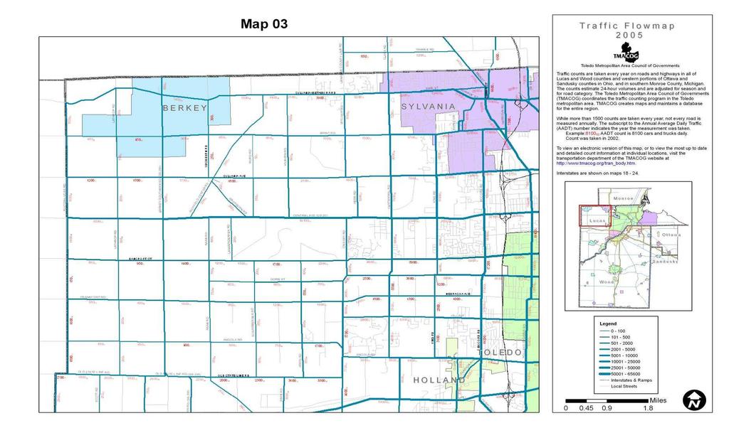
19 Traffic Flowmap 19

20 T I P Map Current TIP map developed using ODOT LRS 20

21 TIP Project Analysis 21
22 Future Projects l County Centerline l Maintenance Crash Locations Updated Traffic Counts Bridge Conditions Pavement Conditions 22
23 Thank You Questions???? 23
Transforming the Maricopa County Department of Transportation (MCDOT) GIS-based Transportation Asset Inventory System June 30, 2016
 GIS-based Transportation Asset Inventory System June 30, 2016") Transforming the Maricopa County Department of Transportation (MCDOT) GIS-based Transportation Asset Inventory System June 30, 2016 Presented By Steve Hossack, GIS Database Administrator 2016 Esri User
Transforming the Maricopa County Department of Transportation (MCDOT) GIS-based Transportation Asset Inventory System June 30, 2016 Presented By Steve Hossack, GIS Database Administrator 2016 Esri User
Office of Enterprise Technology
 Office of Enterprise Technology Transforming the Maricopa Department of Transportation (MCDOT) GIS-based Transportation Asset Inventory System January 21, 2016 Presented By Steve Hossack, GIS Database
2006 GIS-T T Symposium Columbus Ohio
 2006 GIS-T T Symposium Columbus Ohio Creating a Location Based Response System Using ESRI Technology Brian Stevens, CP Woolpert, Inc. Agenda Introduction What is LBRS? History Specifications Proposed Method
Enterprise Linear Referencing at the NYS Department of Transportation
 Enterprise Linear Referencing at the NYS Department of Transportation One Highway Network to Support Many Business Processes May 9, 2018 May 9, 2018 2 Agenda An overview of Linear Referencing How NYSDOT
Maricopa County Department of Transportation (MCDOT) GIS Innovations in Transportation Asset Management
 GIS Innovations in Transportation Asset Management") Maricopa County Department of Transportation (MCDOT) GIS Innovations in Transportation Asset Management Presented By Steve Hossack, GIS Database Administrator 2018 ITE/IMSA Spring Conference Maricopa County
Maricopa County Department of Transportation (MCDOT) GIS Innovations in Transportation Asset Management Presented By Steve Hossack, GIS Database Administrator 2018 ITE/IMSA Spring Conference Maricopa County
FHWA GIS Outreach Activities. Loveland, Colorado April 17, 2012
 FHWA GIS Outreach Activities Loveland, Colorado April 17, 2012 GIS for Improved Decision Making FHWA believes that geographic information systems and other geospatial technologies (remote sensing and GPS)
Landmark LRM. MM and RefPts can be same or different
 1 2 This project began in the fall of 2005. At the time CDOT had three different business units maintaining different LRS s. That is, the beginning and ending reference points and the measured length of
Linear Referencing Systems (LRS) Support for Municipal Asset Management Systems
 Support for Municipal Asset Management Systems") Linear Referencing Systems (LRS) Support for Municipal Asset Management Systems Esri Canada Infrastructure Asset Management Leadership Forum November 1, 2017 Toronto, ON David Loukes, P. Eng., FEC Andy
Linear Referencing Systems (LRS) Support for Municipal Asset Management Systems Esri Canada Infrastructure Asset Management Leadership Forum November 1, 2017 Toronto, ON David Loukes, P. Eng., FEC Andy
GIS-T 2010 Building a Successful Geospatial Data Sharing Framework: A Ohio DOT Success Story
 GIS-T 2010 Building a Successful Geospatial Data Sharing Framework: A Ohio DOT Success Story ODOT District 2 GIS John Puente District 1 GIS Coordinator\ Planning Administrator 2 Interoperability 3 District
NJDOT Pedestrian Safety Analysis Tool 2015 GIS T Conference
 NJDOT Pedestrian Safety Analysis Tool 2015 GIS T Conference NJDOT Pedestrian Safety Analysis Tool Justin Furch GIT Department Manager Michael Baker International Pedestrian Safety in NJ: Has the highest
A Summary of State DOT GIS Activities. Presented at the 2004 AASHTO GIS-T Symposium Rapid City, SD
 A Summary of State DOT GIS Activities Presented at the 2004 AASHTO GIS-T Symposium Rapid City, SD Information Sources E-mail survey of state DOT GIS managers All 51 State DOTs (and DC) responded in 2004
Project Level Traffic Forecasting Summary of Practices from other States. TNMUG March 6, 2008
 Project Level Traffic Forecasting Summary of Practices from other States TNMUG March 6, 2008 TMIP Listserve Query by Jerry Everett Found that at least 4 State DOTs have instituted formal traffic forecasting
Ohio s Linear Based Referencing System (a.k.a. Location Based Response System LBRS), a True State and Local Government Partnership
, a True State and Local Government Partnership") Ohio s Linear Based Referencing System (a.k.a. Location Based Response System LBRS), a True State and Local Government Partnership Ron Cramer Digital Data Technologies, Inc. Joseph Hausman The Ohio Department
Ohio s Linear Based Referencing System (a.k.a. Location Based Response System LBRS), a True State and Local Government Partnership Ron Cramer Digital Data Technologies, Inc. Joseph Hausman The Ohio Department
GIS Support for a Traffic. Delaware
 GIS Support for a Traffic Operations Management Plan in Delaware Geospatial Information Systems for Transportation AASHTO GIS-T, Hershey Pennsylvania March 28th, 2011 David Racca Center for Applied Demography
Statewide State Roads Layer Michigan Geographic Framework Field Definitions
 Statewide State Roads Layer Michigan Geographic Framework Field Definitions (Shapefile Attribute Table) (June 1, 2012 Version 12b) The following field definitions make up the shapefile attribute table
LBRS Ohio s Location-Based Response System
 LBRS Ohio s Location-Based Response System Comprised of state-level statewide datasets for Ohio, including road centerlines with point-based address locations, parcels, and orthophotography Spatially accurate
Updating the Urban Boundary and Functional Classification of New Jersey Roadways using 2010 Census data
 Updating the Urban Boundary and Functional Classification of New Jersey Roadways using 2010 Census data By: Glenn Locke, GISP, PMP 1 GIS-T May, 2013 Presentation Overview Purpose of Project Methodology
The State of Michigan Transportation Asset Management Council 2006 PASER Survey Of Shiawassee County
 The State of Michigan Transportation Asset Management Council 2006 PASER Survey Of Shiawassee County Prepared by the Genesee County Metropolitan Planning Commission Staff 1 The State of Michigan Transportation
Linear Referencing in Boulder County, CO. Getting Started
 Linear Referencing in Boulder County, CO Getting Started 1 Authors Janie Pierre GIS Technician, Boulder County Road centerline and storm sewer geodatabases & maps John Mosher GIS Specialist, Boulder County
A Summary of State DOT GIS Activities. Presented at the 2000 AASHTO GIS-T Symposium Minneapolis, MN
 A Summary of State DOT GIS Activities Presented at the 2000 AASHTO GIS-T Symposium Minneapolis, MN Information Sources E-mail survey of state DOT GIS managers 49 State DOTs responded in 2000 Results compared
Application of GIS in Public Transportation Case-study: Almada, Portugal
 Case-study: Almada, Portugal Doutor Jorge Ferreira 1 FSCH/UNL Av Berna 26 C 1069-061 Lisboa, Portugal +351 21 7908300 jr.ferreira@fcsh.unl.pt 2 FSCH/UNL Dra. FCSH/UNL +351 914693843, leite.ines@gmail.com
A Summary of State DOT GIS Activities. Presented at the 1999 AASHTO GIS-T Symposium San Diego, CA
 A Summary of State DOT GIS Activities Presented at the 1999 AASHTO GIS-T Symposium San Diego, CA Information Sources Telephone survey of state DOT GIS managers 49 State DOTs surveyed in 1999 Results compared
Winter Maintenance on Ontario s Highways
 Ministry of Transportation Winter Maintenance on Ontario s Highways MTO Eastern Region November 18, 2015, Northumberland County Council Outline 1. Winter Maintenance Areas - Eastern Region 2. Winter Maintenance
A case study of Pavement Management in Chelan County
 INTEGRATING PAVEMENT MANAGEMENT AND GIS A case study of Pavement Management in Chelan County Our Road dto Full lladoption of a PMS The evolution of PMS at Chelan County Our current process Use of GIS to
Summary of Best practices in Linear Referencing Systems (LRS)
") Summary of Best practices in Linear Referencing Systems (LRS) Presented By: Dr. Simon Lewis Delcan Philadelphia Regional ESRI GIS Transportation Special Interest Group February 19, 2008 Chester County
Summary of Best practices in Linear Referencing Systems (LRS) Presented By: Dr. Simon Lewis Delcan Philadelphia Regional ESRI GIS Transportation Special Interest Group February 19, 2008 Chester County
GIS Technology and Tools for Long Range Transportation Planning in the National Park Service
 GIS Technology and Tools for Long Range Transportation Planning in the National Park Service Geospatial Information Systems for Transportation Symposium Loveland, Colorado April 16, 2012 Nell Blodgett
Texas A&M University
 Texas A&M University CVEN 658 Civil Engineering Applications of GIS Hotspot Analysis of Highway Accident Spatial Pattern Based on Network Spatial Weights Instructor: Dr. Francisco Olivera Author: Zachry
Introduction to Ohio Landslide Hazard Rating System and Landslide Risk Management. By Prof. Robert Liang
 Introduction to Ohio Landslide Hazard Rating System and Landslide Risk Management By Prof. Robert Liang Background Landslides cause public risk (accident: injury/loss of life). Impact on regional economy
California Urban Infill Trip Generation Study. Jim Daisa, P.E.
 California Urban Infill Trip Generation Study Jim Daisa, P.E. What We Did in the Study Develop trip generation rates for land uses in urban areas of California Establish a California urban land use trip
Creating a Pavement Management System Using GIS
 Christopher Castruita PPD 631 Prof. Barry Waite & Prof. Bonnie Shrewsbury Creating a Pavement Management System Using GIS Problem Definition As is the case with many cities, the city of La Cañada Flintridge
The WVDOT Planning Process
 The WVDOT Planning Process Agenda Planning Division Components Statewide Planning Components of the Process Handoff Points Alphabet Soup of Acronyms Planning Division Components Geospatial Transportation
INDOT Office of Traffic Safety
 Intro to GIS Spatial Analysis INDOT Office of Traffic Safety Intro to GIS Spatial Analysis INDOT Office of Traffic Safety Kevin Knoke Section 130 Program Manager Highway Engineer II Registered Professional
High Speed / Commuter Rail Suitability Analysis For Central And Southern Arizona
 High Speed / Commuter Rail Suitability Analysis For Central And Southern Arizona Item Type Reports (Electronic) Authors Deveney, Matthew R. Publisher The University of Arizona. Rights Copyright is held
What is 511? Need for 511 Services. Development & Deployment of Regional Road and Weather Information Supporting 511 Traveler Services
 Development & Deployment of Regional Road and Weather Information Supporting 511 Traveler Services Leon F. Osborne University of North Dakota Regional Weather Information Center Grand Forks, ND David L.
GPS to LRM: Integration of Spatial Point Features with Linear Referencing Methods
 GPS to LRM: Integration of Spatial Point Features with Linear Referencing Methods Final Report Sponsored by the Research and Special Programs Administration, U.S. Department of Transportation, University
GIS and the Other Enterprise Database
 GIS-T T Symposium GIS and the Other Enterprise Database March 31, 2004 Rapid City, South Dakota 1 Introduction Personal thoughts on recent evolution of GIS Shift in perspective from GIScentric to asset-centric
Office of Technology Partnerships GIS Collaboration
 Office of Technology Partnerships GIS Collaboration State GIS Update April 21, 2017 Mark Holmes, GISP Outline MGF Upgrade Project Census Programs Imagery Update LiDAR Update Open Discussion 2 MGF Background
KING FAHD UNIVERSITY OF PETROLEUM & MINERALS
 KING FAHD UNIVERSITY OF PETROLEUM & MINERALS Department of City & Regional Planning Introduction To GIS (CRP 514) Identifying & Planning Public School Facility In California Using GIS Presented to Dr.
ENHANCING ROAD SAFETY MANAGEMENT WITH GIS MAPPING AND GEOSPATIAL DATABASE
 Abstract ENHANCING ROAD SAFETY MANAGEMENT WITH GIS MAPPING AND GEOSPATIAL DATABASE Dr Wei Liu GHD Reliable and accurate data are needed in each stage of road safety management in order to correctly identify
TRAVEL DEMAND MODEL. Chapter 6
 Chapter 6 TRAVEL DEMAND MODEL As a component of the Teller County Transportation Plan development, a computerized travel demand model was developed. The model was utilized for development of the Transportation
ArcGIS Pipeline Referencing An Introduction. Anjali Bhangay William Isley
 ArcGIS Pipeline Referencing An Introduction Anjali Bhangay William Isley Pipeline Referencing Overview Information Model Pipeline Referencing Overview Information Model ArcGIS Pro Pipeline Referencing
Using Public Information and Graphics Software in Graduate Highway Safety Research at Worcester Polytechnic Institute
 Using Public Information and Graphics Software in Graduate Highway Safety Research at Worcester Polytechnic Institute C.E. Conron, C. Silvestri, A. Gagne, M.H. Ray Department of Civil and Environmental
Geospatial Big Data Analytics for Road Network Safety Management
 Proceedings of the 2018 World Transport Convention Beijing, China, June 18-21, 2018 Geospatial Big Data Analytics for Road Network Safety Management ABSTRACT Wei Liu GHD Level 1, 103 Tristram Street, Hamilton,
Uses of Travel Demand Models Beyond the MTP. Janie Temple Transportation Planning and Programming Division
 Uses of Travel Demand Models Beyond the MTP Janie Temple Transportation Planning and Programming Division October 12, 2011 Presentation Outline What is a Travel Demand Model? Cautionary notes on using
How GIS Can Help With Tribal Safety Planning
 How GIS Can Help With Tribal Safety Planning Thomas A. Horan, PhD Brian Hilton, PhD Arman Majidi, MAIS Center for Information Systems and Technology Claremont Graduate University Goals & Objectives This
CDTC s Regional Sidewalk Inventory
 CDTC s Regional Sidewalk Inventory Overview CDTC created a GIS-based inventory of existing sidewalk infrastructure in all 77 municipalities within CDTC s planning area. This inventory indicates presence
An Integrated Approach to Statewide Travel Modeling Applications in Delaware
 TRB 88 th Annual Meeting Washington, D.C. January 14 th, 29 An Integrated Approach to Statewide Travel Modeling Applications in Delaware The Context: Challenges for Today s Modelers: Personnel: Vacant
National Park Service Safety Management
 National Park Service Safety Management Locating Crashes Spatially from the National Park Service Service-wide Traffic Accident Reporting System (STARS) Database By Daniel Van Gilder Federal Highway Administration
Using GIS to Determine Goodness of Fit for Functional Classification. Eric Foster NWMSU MoDOT
 Using GIS to Determine Goodness of Fit for Functional Classification Eric Foster NWMSU MoDOT Northwest Missouri State Masters of GIScience Degree Program University All Online Coursework Missouri Department
UTILIZING GIS IN NEXT GENERATION Tennessee Information for Public Safety. Presented by State of TN, OIR-GIS Services
 UTILIZING GIS IN NEXT GENERATION 9-1-1 Tennessee Information for Public Safety Presented by State of TN, OIR-GIS Services Next Generation 9-1-1 WHAT IT IS AND HOW IT WORKS Next Generation 9-1-1 IP (Internet
Iowa Department of Transportation Office of Transportation Data GIS / CAD Integration
 Iowa Department of Transportation Office of Transportation Data GIS / CAD Integration From GIS data to CAD graphics - Iowa DOT's workflow utilizing GeoMedia and MicroStation to develop map products. Mark
Data Driven Approaches to Crime and Traffic Safety
 Data Driven Approaches to Crime and Traffic Safety Baltimore County Police Department Traffic Safety is Public Safety Baltimore County Police Department Population: 801,000 Square Miles: 610 Sworn Personnel:
GIS for the Non-Expert
 GIS for the Non-Expert Ann Forsyth University of Minnesota February 2006 GIS for the Non-Expert 1. Definitions and problems 2. Measures being tested in Twin Cities Walking Study Basic approach, data, variables
Technical Memorandum #2 Future Conditions
 Technical Memorandum #2 Future Conditions To: Dan Farnsworth Transportation Planner Fargo-Moorhead Metro Council of Governments From: Rick Gunderson, PE Josh Hinds PE, PTOE Houston Engineering, Inc. Subject:
Transforming Geospatial Data for Visualization with D3
 Transforming Geospatial Data for Visualization with D3 FOSS4G Boston August 17, 2017 Beatrice Jin and Benjamin Krepp Boston Region Metropolitan Planning Organization Agenda Who we are Project context Implementation
Road Ahead: Linear Referencing and UPDM
 Road Ahead: Linear Referencing and UPDM Esri European Petroleum GIS Conference November 7, 2014 Congress Centre, London Your Work Making a Difference ArcGIS Is Evolving Your GIS Is Becoming Part of an
1st Annual Southwest Ohio Snow Conference April 8, 2010 Abner F. Johnson, Office of Maintenance - RWIS Coordinator
 1st Annual Southwest Ohio Snow Conference April 8, 2010 Abner F. Johnson, Office of Maintenance - RWIS Coordinator The Ohio Department of Transportation ODOT has approximately 5500 full-time employees
MANUAL FOR ROCKFALL INVENTORY PREPARED BY:
 MANUAL FOR ROCKFALL INVENTORY PREPARED BY: THE OHIO DEPARTMENT OF TRANSPORTATION OFFICE OF GEOTECHNICAL ENGINEERING 1980 WEST BROAD STREET COLUMBUS, OHIO 43223 DECEMBER 2016 TABLE OF CONTENTS SECTION 100
Transportation and Road Weather
 Portland State University PDXScholar TREC Friday Seminar Series Transportation Research and Education Center (TREC) 4-18-2014 Transportation and Road Weather Rhonda Young University of Wyoming Let us know
MODELING OF 85 TH PERCENTILE SPEED FOR RURAL HIGHWAYS FOR ENHANCED TRAFFIC SAFETY ANNUAL REPORT FOR FY 2009 (ODOT SPR ITEM No.
 MODELING OF 85 TH PERCENTILE SPEED FOR RURAL HIGHWAYS FOR ENHANCED TRAFFIC SAFETY ANNUAL REPORT FOR FY 2009 (ODOT SPR ITEM No. 2211) Submitted to: Ginger McGovern, P.E. Planning and Research Division Engineer
City of Saginaw Right of Way Division Snow and Ice Removal Policy January 18, 2016
 Snow and Ice Removal Policy January 18, 2016 It is the policy of the to provide snowplowing and ice removal services in order to: Provide safe traveling conditions for motorists and pedestrians Assist
Cipra D. Revised Submittal 1
 Cipra D. Revised Submittal 1 Enhancing MPO Travel Models with Statewide Model Inputs: An Application from Wisconsin David Cipra, PhD * Wisconsin Department of Transportation PO Box 7913 Madison, Wisconsin
 SEDA-COG MPO Long Range Transportation Plan, 2016-2040 Appendix E Comment Cluster Analysis Methodology Cluster Analysis of Comment Data compiled by the State Transportation Commission and PennDOT and
Term Paper USING GIS IN TRANSPORTATION AND ITS APPLICATIONS
 Term Paper USING GIS IN TRANSPORTATION AND ITS APPLICATIONS For CRP 514: Introduction to GIS Term (101) By Mohammed Salem Ba-naimoon IDNO: 200805620 Course Instructor: Dr. Baqer M. Al-Ramadan Contents
Salt Reduction using Innovative
 Salt Reduction using Innovative Technology 2018 Road Salt Symposium Bill Schneider Winter Maintenance Problem Transportation agencies are tasked with treating roadways during snow and ice events ODOT spends
BRIEFING BOOK. Natural Gas Energy Parcel Level GIS
 Natural Gas Energy Parcel Level GIS BRIEFING BOOK Examination of techniques & protocols for incorporating National Parcel Layer content to vastly reduce cost of transaction to better meet accelerating
MINNESOTA SIDE Draft TRANSPORTATION IMPROVEMENT PROGRAM
 MINNESOTA SIDE Draft TRANSPORTATION IMPROVEMENT PROGRAM 2018-2021 April, 2017 FISCAL YEARS 2018-2021 MINNESOTA SIDE Draft TRANSPORTATION IMPROVEMENT PROGRAM FOR THE GRAND FORKS - EAST GRAND FORKS METROPOLITAN
High Friction Surface Treatment on Bridge Safety
 High Friction Surface Treatment on Bridge Safety Brian Porter/Rebecca Szymkowski- WisDOT Andrea Bill- UW-Madison TOPS Lab Objectives Weather in WI can be harsh Bridges can be problematic in inclement weather
How GIS based Visualizations Support Land Use and Transportation Modeling
 How GIS based Visualizations Support Land Use and Transportation Modeling ESRI International Users Conference San Diego, CA - July 23, 2015 Prepared by: Troy Hightower Introduction This presentation will
Appendix B. Land Use and Traffic Modeling Documentation
 Appendix B Land Use and Traffic Modeling Documentation Technical Memorandum Planning Level Traffic for Northridge Sub-Area Study Office of Statewide Planning and Research Modeling & Forecasting Section
GIS PROTOCOL AND DATA STRUCTURES FOR THE TEXAS TRAVEL DEMAND PACKAGE. August Research Report
 I. Report No. 2. Government Accession No. TX-94/947-8 4. Title and Subtitle GIS PROTOCOL AND DATA STRUCTURES FOR THE TEXAS TRAVEL DEMAND PACKAGE Technical Report Docwnentation Page 3. Recipient's Catalog
Geotechnical Risks and Slope Management Systems: An FHWA Perspective
 August 20, 2010 10 th Annual Technical Forum Geohazards Impacting Transportation in the Appalachian Region Geotechnical Risks and Slope Management Systems: An FHWA Perspective Silas C. Nichols, PE, Senior
Expanding the GSATS Model Area into
 Appendix A Expanding the GSATS Model Area into North Carolina Jluy, 2011 Table of Contents LONG-RANGE TRANSPORTATION PLAN UPDATE 1. Introduction... 1 1.1 Background... 1 1.2 Existing Northern Extent of
Visualization of Origin- Destination Commuter Flow Using CTPP Data and ArcGIS
 Visualization of Origin- Destination Commuter Flow Using CTPP Data and ArcGIS Research & Analysis Department Southern California Association of Governments 2015 ESRI User Conference l July 23, 2015 l San
PRECAP. Rivers Breakout Session Final Presentation CAPSTONE 14
 Rivers Breakout Session Final Presentation CAPSTONE 14 Rivers Session Team -Army Corps of Engineers -3 Divisions, 4 Districts -Navigation & Emergency Management -U.S. Coast Guard -U.S. Department of Transportation
GIS: A Comprehensive History From the Victorian Era to Present. Matthew West DVRPC Slide 1 of 237
 GIS: A Comprehensive History From the Victorian Era to Present DVRPC Slide 1 of 237 GIS in the Victorian Age Little known fact: GIS actually began in the early stages of the Victorian Era Through the Industrial
A COMPARATIVE STUDY OF THE APPLICATION OF THE STANDARD KERNEL DENSITY ESTIMATION AND NETWORK KERNEL DENSITY ESTIMATION IN CRASH HOTSPOT IDENTIFICATION
 A COMPARATIVE STUDY OF THE APPLICATION OF THE STANDARD KERNEL DENSITY ESTIMATION AND NETWORK KERNEL DENSITY ESTIMATION IN CRASH HOTSPOT IDENTIFICATION Yue Tang Graduate Research Assistant Department of
Python Scripting for Regional Land Use Data Management and QC Workflow
 Python Scripting for Regional Land Use Data Management and QC Workflow 2015 ESRI User Conference July 21, 2015 San Diego, CA Jung Seo, Frank Wen, Simon Choi and Tom Vo Research & Analysis Southern California
PILOT STUDY: PAVEMENT VISUAL CONDITION AND FRICTION AS A PERFORMANCE MEASURE FOR WINTER OPERATIONS
 1 PILOT STUDY: PAVEMENT VISUAL CONDITION AND FRICTION AS A PERFORMANCE MEASURE FOR WINTER OPERATIONS Nishantha Bandara, Ph.D., P.E. Department of Civil Engineering Lawrence Technological University 21000
GIS. URBAN PLANNING and DEVELOPMENT APPLICATIONS of. Said Easa and Yupo Chan. GSttingen
 URBAN PLANNING and DEVELOPMENT APPLICATIONS of GIS SUB GSttingen 213 473 844 2001 A 2251 Sponsored by Geographic Information Systems Committee of the Urban Planning and Development Division American Society
Validation of Location Referencing -Methods
 Validation of Location Referencing -Methods Networks for Mobility Stuttgart, September 28, 2012 Rainer Schützle, M.Sc. Institute of Engineering Geodesy University of Stuttgart rainer.schuetzle@ingeo.uni-stuttgart.de
FHWA Planning Data Resources: Census Data Planning Products (CTPP) HEPGIS Interactive Mapping Portal
 HEPGIS Interactive Mapping Portal") FHWA Planning Data Resources: Census Data Planning Products (CTPP) HEPGIS Interactive Mapping Portal Jeremy Raw, P.E. FHWA, Office of Planning, Systems Planning and Analysis August 2017 Outline Census
FHWA Planning Data Resources: Census Data Planning Products (CTPP) HEPGIS Interactive Mapping Portal Jeremy Raw, P.E. FHWA, Office of Planning, Systems Planning and Analysis August 2017 Outline Census
LRS Task Force June 13, REVISION HISTORY
 North Carolina Department of Transportation Geographic Information Systems (GIS) Unit LINEAR REFERENCING SYSTEM (LRS) PROJECT DEFINITION Version 1.0 REVISION HISTORY Date Document Manager Revision Purpose
TO THE REPORT: A STRATEGIC PLAN TO REDUCE VEHICLE- ANIMAL ACCIDENTS IN NORTHEAST OHIO
 ADDENDUM II TO THE REPORT: A STRATEGIC PLAN TO REDUCE VEHICLE- ANIMAL ACCIDENTS IN NORTHEAST OHIO The report A Strategic Plan to Reduce Vehicle-Animal Accidents in Northeast Ohio published June, 2009 1,
Geoprocessing Tools at ArcGIS 9.2 Desktop
 Geoprocessing Tools at ArcGIS 9.2 Desktop Analysis Tools Analysis Tools \ Extract Clip Analysis Tools \ Extract Select Analysis Tools \ Extract Split Analysis Tools \ Extract Table Select Analysis Tools
Welcome. Noise Production Ceilings. How Dutch environmental legislation affects railway planning. Gerard Groenveld July 17, 2014
 Welcome Noise Production Ceilings How Dutch environmental legislation affects railway planning Gerard Groenveld July 17, 2014 https://www.youtube.com/watch?v=vk57j7kmp3i The Netherlands Agenda About ProRail
Merging and DOT Data
 Merging 9-1-1 and DOT Data Presented By: Ken Nelson - GIO - State of Kansas Patrick Melancon - Product Manager - GeoComm Date: Wednesday 9/27/2017 @10:30am Primary NG911 project goals Deploy an IP-based
MPC-425 January 1, December 31, 2013
 MPC-425 January 1, 2013- December 31, 2013 Project Title: Building a Sustainable GIS Framework for Supporting a Tribal Transportation Program University: North Dakota State University Principal Investigators:
Office of Geographic Information Systems
 Office of Geographic Information Systems Print this Page Spring 2009 - Desktop GIS: Dakota County GIS Extensions in ArcMap By Dan Castaneda In the past, the Office of GIS has created desktop extensions
GIS BASED OPTIMAL ROUTE ANALYSIS FOR THE TRANSPORTATION OF SOLID WASTE- A CASE STUDY FROM HYDERABAD CITY
 GIS BASED OPTIMAL ROUTE ANALYSIS FOR THE TRANSPORTATION OF SOLID WASTE- A CASE STUDY FROM HYDERABAD CITY Ramesh Kumar.R 1, Prof. Ch. Ramakrishna 2 1,2 Department of Environmental Studies, GITAM University,
Maryland Transit Administration (MTA) Bus Accident Mapping and Analysis Application
 Bus Accident Mapping and Analysis Application") Maryland Transit Administration (MTA) Bus Accident Mapping and Analysis Application Ralign Wells, MTA Administrator Bernadette Bridges, MTA Chief Safety Officer Office of Safety, Quality Assurance, and
Maryland Transit Administration (MTA) Bus Accident Mapping and Analysis Application Ralign Wells, MTA Administrator Bernadette Bridges, MTA Chief Safety Officer Office of Safety, Quality Assurance, and
Annual TTFO Meeting April 10, 2018 Michael J. Wittman, P.S. Chief Surveyor / GIS Coordinator
 Annual TTFO Meeting April 10, 2018 Michael J. Wittman, P.S. Chief Surveyor / GIS Coordinator Text Book Definition: Layman Terms: An organized collection of hardware, software and geographic data designed
Reliability and Safety Prediction for Planning
 Reliability and Safety Prediction for Planning presented by Rich Margiotta, Cambridge Systematics Beth Alden, Hillsborough County December 7, 2016 Background Describe the effort to inject operations and
Maryland Transit Administration (MTA) Bus Accident Mapping and Analysis Application
 Bus Accident Mapping and Analysis Application") Maryland Transit Administration (MTA) Bus Accident Mapping and Analysis Application Ralign Wells, MTA Administrator Bernadette Bridges, MTA Chief Safety Officer Office of Safety, Quality Assurance, and
Maryland Transit Administration (MTA) Bus Accident Mapping and Analysis Application Ralign Wells, MTA Administrator Bernadette Bridges, MTA Chief Safety Officer Office of Safety, Quality Assurance, and
The Northwest Environmental Training Center presents:
 The Northwest Environmental Training Center presents: Introduction to ArcGIS 9 for Fisheries and Wildlife Biology Applications Course ID: GIS - 400 October 1-3, 2008, 8:30 A.M. to 5 P.M. **Venue Change**
INTRODUCTION TO GEOGRAPHIC INFORMATION SYSTEM By Reshma H. Patil
 INTRODUCTION TO GEOGRAPHIC INFORMATION SYSTEM By Reshma H. Patil ABSTRACT:- The geographical information system (GIS) is Computer system for capturing, storing, querying analyzing, and displaying geospatial
Prepared for: San Diego Association Of Governments 401 B Street, Suite 800 San Diego, California 92101
 Activity-Based Travel Model Validation for 2012 Using Series 13 Data: Coordinated Travel Regional Activity Based Modeling Platform (CT-RAMP) for San Diego County Prepared for: San Diego Association Of
Appendixx C Travel Demand Model Development and Forecasting Lubbock Outer Route Study June 2014
 Appendix C Travel Demand Model Development and Forecasting Lubbock Outer Route Study June 2014 CONTENTS List of Figures-... 3 List of Tables... 4 Introduction... 1 Application of the Lubbock Travel Demand
US 20 Highway Safety Study
 US 20 Highway Safety Study Corvallis City Limits to Springhill Road, Albany Prepared for Prepared by December 2016 US 20 HIGHWAY SAFETY STUDY FINAL REPORT Benton County, Oregon Prepared for: Oregon Department
Cost-Benefit Analysis of the Pooled- Fund Maintenance Decision Support System: Case Study
 Cost-Benefit Analysis of the Pooled- Fund Maintenance Decision Support System: Case Study Zhirui Ye (WTI) Xianming Shi (WTI) Christopher K. Strong (City of Oshkosh) 12 th AASHTO-TRB TRB Maintenance Management