Title Accuracy assessment of GIS techniques for measuring volumetric loss at Mount St. Helens
|
|
|
- Duane Perkins
- 5 years ago
- Views:
Transcription
1 Andrew Nelson Geog Digital Terrain Analysis Portland State University 7 Dec, 2017 Title Accuracy assessment of GIS techniques for measuring volumetric loss at Mount St. Helens Abstract The 1980 eruption of Mount St. Helens was the most significant volcanic event in modern US history, drastically altering the physical and natural characteristics of the mountain itself and the surrounding landscape. Continuous advances in remote sensing and geographic information systems make it possible to monitor and analyze such changes at the earth s surface with increasing ease. This researcher was curious about how accurate commonly used techniques of volumetric analysis using digital elevation models (DEMs) in a geographic information system are at estimating volumetric loss. By comparing 30m DEMs generated from data collected prior to and following the 1980 eruption, volume loss was calculated using three methods - DEM differencing, Cut Fill and TIN Surface Difference - and compared to the official USGS estimate based on uncompacted deposits. In addition, 10m DEMs were interpolated from the original 30m DEMs to test the effect this would have on the Cut Fill volume calculation. The study found that these techniques produced results between 3-3.5% greater than the USGS estimate, within an acceptable range of accuracy for most purposes. Additionally, the use of interpolated surfaces did not have a significant impact on volume calculation. Reasons for discrepancies in estimates include the fact that the post-eruption DEM was generated 24 years after the eruption; this is a significant amount of time for surficial changes to occur through a variety of processes. Also, this researcher was unable to identify the exact study area used by USGS in estimating volumetric loss; as a result, there are almost certainly areas that this study included in its calculations that theirs did not (and vice versa). Keywords Mount St. Helens, digital elevation model, volumetric analysis, GIS, remote sensing

2 Accuracy Assessment of GIS Techniques for Measuring Volumetric Loss at Mount St. Helens GEOG 493 Digital Terrain Analysis Andrew Nelson Data source: ESRI WorldImagery


3 RESEARCH QUESTIONS o What are the different techniques of performing volumetric analysis using digital elevation models in ArcMap? o How do the results of these methods compare to volumetric change estimates made using traditional techniques? o What effect will downscaling DEM resolution using interpolation have on volumetric calculation?

4 STUDY AREA Mount St. Helens was chosen as study area due to: o Large volumetric change from 1980 eruption o Availability of digital elevation models pre- and post-eruption o Well-researched, good deal of information available Source: USGS CVO Many studies target total volumetric change, I am primarily interested in volume removed.

5 DATASETS COLLECTED o 30m Pre-Eruption DEM o 30m Post-Eruption DEM CREATED o 30m Pre- and Post-Eruption Hillshades o Interpolated 10m Pre- and Post-Eruption DEMs o Interpolated 10m Pre- and Post-Eruption Hillshades o Pre-Eruption TIN Model o Post-Eruption TIN Model

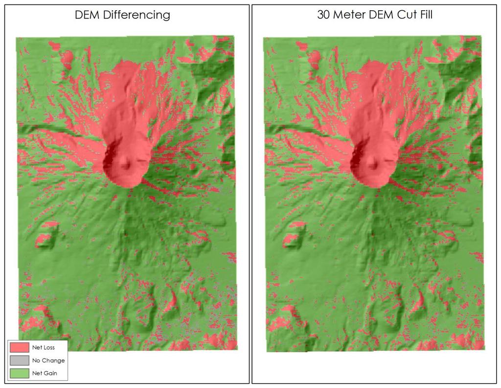
6 ANALYSIS DEM DIFFERENCING o Use Raster Calculator to find elevation difference between pre/post-eruption DEMs o Output = elevation change; to find volume, multiply this value by area o Cells with elevation change between -1 and 1 m classed as No Change
 negative values represent areas of fill (volumetric gain) o Cells with volume between -900 and 900 m 3 classed as No")
7 ANALYSIS CUT FILL o Spatial Analyst toolbox o Calculates areas and volumes of change o Output = positive values represent areas of cut (volumetric loss) negative values represent areas of fill (volumetric gain) o Cells with volume between -900 and 900 m 3 classed as No Change
 o Cells with volume between -900 and 900 m 3 classed as No")
8 ANALYSIS SURFACE DIFFERENCE o 3D Analyst toolbox -> Triangulated Surface o Similar to Cut Fill but performs analysis on TIN models o Output = areas above/below reference model (in this case, posteruption) o Cells with volume between -900 and 900 m 3 classed as No Change

9 ANALYSIS CUT FILL INTERPOLATED 10m DEM o Extraction -> Sample o Interpolated 10m pre/post eruption DEMs using Spline o Performed Cut Fill using these DEMs as input
10 RESULTS
11 RESULTS USGS 30m DEM Difference 30m DEM Cut Fill TIN Surface Difference Interpolated 10m DEM Cut Fill Estimated Volume Removed (m 3 ) 2,828,852, ,927,595, ,927,391, ,914,970, ,926,926, Difference (m 3 ) Percent Difference 98,742, ,538, ,117, ,073, o Each DEM-based technique resulted in volumetric loss of about 2.93 billion m 3 o TIN Surface Difference was slightly lower at 2.91 billion m 3, closest to USGS estimate o Little difference in appearance of output rasters produced by each method o Interpolation did not have significant effect on volume calculations
12 RESULTS Reasons for discrepancies o Study Area o Post-Eruption DEM too recent o DEM resolution too coarse o Pre-Eruption DEM not LiDAR-derived o Information-loss during conversion/interpolation (raster-to-tin)
13 SOURCES University of Washington Department of Earth and Space Sciences, USGS Mount St. Helens Fact Sheet
Keywords: Mount St. Helens, interpolation, GIS, change detection, scale, spatial techniques
 A sensitivity analysis of scale and sampling techniques on volumetric change on Mount St. Helens Douglas Thalacker Portland State University thal2@pdx.edu Abstract Mount St. Helens (MSH) underwent significant
A Temporal Hydrologic Database for Rapidly Changing Landscapes
 A Temporal Hydrologic Database for Rapidly Changing Landscapes Using Mt. St. Helens in Washington as a Pilot Site Adam Mosbrucker Geog 575 BACKGROUND: Client / User U.S. Geological Survey Cascades Volcano
Erin Costello A comparison of Solar Radiation Modeling Tools
 Erin Costello A comparison of Solar Radiation Modeling Tools The Oregon Department of Environmental Quality uses effective shade as an indicator of water quality parameters as well as a target for restoration
Working with Digital Elevation Models and Digital Terrain Models in ArcMap 9
 Working with Digital Elevation Models and Digital Terrain Models in ArcMap 9 1 TABLE OF CONTENTS INTRODUCTION...3 WORKING WITH DIGITAL TERRAIN MODEL (DTM) DATA FROM NRVIS, CITY OF KITCHENER, AND CITY OF
Working with Digital Elevation Models and Spot Heights in ArcMap
 Working with Digital Elevation Models and Spot Heights in ArcMap 10.3.1 1 TABLE OF CONTENTS INTRODUCTION... 3 WORKING WITH SPOT HEIGHTS FROM NRVIS, CITY OF KITCHENER, AND CITY OF TORONTO...4 WORKING WITH
Using ArcGIS for Hydrology and Watershed Analysis:
 Using ArcGIS 10.2.2 for Hydrology and Watershed Analysis: A guide for running hydrologic analysis using elevation and a suite of ArcGIS tools Anna Nakae Feb. 10, 2015 Introduction Hydrology and watershed
Digital Elevation Models (DEM)
") Digital Elevation Models (DEM) Digital representation of the terrain surface enable 2.5 / 3D views Rule #1: they are models, not reality Rule #2: they always include some errors (subject to scale and data
Digital Elevation Models (DEM) Digital representation of the terrain surface enable 2.5 / 3D views Rule #1: they are models, not reality Rule #2: they always include some errors (subject to scale and data
Spatial Analyst. By Sumita Rai
 ArcGIS Extentions Spatial Analyst By Sumita Rai Overview What does GIS do? How does GIS work data models Extension to GIS Spatial Analyst Spatial Analyst Tasks & Tools Surface Analysis Surface Creation
GIS APPLICATIONS IN SOIL SURVEY UPDATES
 GIS APPLICATIONS IN SOIL SURVEY UPDATES ABSTRACT Recent computer hardware and GIS software developments provide new methods that can be used to update existing digital soil surveys. Multi-perspective visualization
Popular Mechanics, 1954
 Introduction to GIS Popular Mechanics, 1954 1986 $2,599 1 MB of RAM 2017, $750, 128 GB memory, 2 GB of RAM Computing power has increased exponentially over the past 30 years, Allowing the existence of
A Detailed Examination of DTM Creation Methods and Sources. Study Area Overview
 A Detailed Examination of DTM Creation Methods and Sources Adam Mosbrucker & Melinda Lamb Geography 593: Dec. 2 nd, 2010 Study Area Overview Mt. St. Helens -active volcano many eruptions in the past 30
Hydrologic Engineering Applications of Geographic Information Systems
 Hydrologic Engineering Applications of Geographic Information Systems Davis, California Objectives: The participant will acquire practical knowledge and skills in the application of GIS technologies for
Identifying Wildfire Risk Areas in Western Washington State
 Identifying Wildfire Risk Areas in Western Washington State Matthew Seto University of Washington Tacoma GIS Certification Program URISA 2015 Undergraduate Geospatial Skills Competition Introduction 2014
Outcrop suitability analysis of blueschists within the Dry Lakes region of the Condrey Mountain Window, North-central Klamaths, Northern California
 Outcrop suitability analysis of blueschists within the Dry Lakes region of the Condrey Mountain Window, North-central Klamaths, Northern California (1) Introduction: This project proposes to assess the
Suitability Analysis on Second Home Areas Selection in Smithers British Columbia
 GEOG 613 Term Project Suitability Analysis on Second Home Areas Selection in Smithers British Columbia Zhengzhe He November 2005 Abstract Introduction / background Data Source Data Manipulation Spatial
Detailed Surficial Geologic Mapping and Terrain Analysis of the Blue Hills Felsenmeer Valley, Rusk County, Wisconsin
 Detailed Surficial Geologic Mapping and Terrain Analysis of the Blue Hills Felsenmeer Valley, Rusk County, Wisconsin Department of Geology, University of Wisconsin, Eau Claire, WI 54702 Jeremy Hinke and
Use of ArcGIS Applications for Analysis and Representation of the Terrains: The Case Study of Alakır River Sub-basin
 Use of ArcGIS Applications for Analysis and Representation of the Terrains: The Case Study of Alakır River Sub-basin Ahmet BENLİAY, Tahsin YILMAZ and H. Ekin OKTAY 1 Introduction 3D visualizations have
An Information Model for Maps: Towards Cartographic Production from GIS Databases
 An Information Model for s: Towards Cartographic Production from GIS Databases Aileen Buckley, Ph.D. and Charlie Frye Senior Cartographic Researchers, ESRI Barbara Buttenfield, Ph.D. Professor, University
MAPPING POTENTIAL LAND DEGRADATION IN BHUTAN
 MAPPING POTENTIAL LAND DEGRADATION IN BHUTAN Moe Myint, Geoinformatics Consultant Rue du Midi-8, CH-1196, Gland, Switzerland moemyint@bluewin.ch Pema Thinley, GIS Analyst Renewable Natural Resources Research
Volcanic Hazards of Mt Shasta
 Volcanic Hazards of Mt Shasta Introduction Mt Shasta is a volcano in the northern part of California. Although it has been recently inactive for over 10,000 years. However, its eruption would cause damage
Applied Cartography and Introduction to GIS GEOG 2017 EL. Lecture-2 Chapters 3 and 4
 Applied Cartography and Introduction to GIS GEOG 2017 EL Lecture-2 Chapters 3 and 4 Vector Data Modeling To prepare spatial data for computer processing: Use x,y coordinates to represent spatial features
Trail Flow: Analysis of Drainage Patterns Affecting a Mountain Bike Trail
 Andy Belcher BAE 590 Professor Huffman 12.9.11 Location Trail Flow: Analysis of Drainage Patterns Affecting a Mountain Bike Trail The location of the project area rests in the Cary area of Wake County,
UPDATING AND REFINEMENT OF NATIONAL 1: DEM. National Geomatics Center of China, Beijing
 UPDATING AND REFINEMENT OF NATIONAL 1:500000 DEM Jian-jun LIU a, Dong-hua WANG a, Yao-ling SHANG a, Wen-hao ZHAO a Xi KUAI b a National Geomatics Center of China, Beijing 100830 b School of Resources and
Lidar-derived Hydrography as a Source for the National Hydrography Dataset
 Lidar-derived Hydrography as a Source for the National Hydrography Dataset Lidar-Derived Hydrography, Bathymetry, and Topobathymetry in the National Hydrography Dataset and 3-Dimensional Elevation Program
Creating Watersheds and Stream Networks. Steve Kopp
 Creating Watersheds and Stream Networks Steve Kopp Workshop Overview Demo Data Understanding the tools Elevation Data Types DEM : Digital Elevation Model bare Earth DSM : Digital Surface Model Data Structure
Volcanic Deformation and Evolution.
 Volcanic Deformation and Evolution of Mt. Saint SitHelens http://pubs.usgs.gov/sim/3008/ B. A. Digital perspective view derived from USGS Digital Elevation Model (DEM) of Mount St. Helens as seen from
Data Set Projection Checklist
 1 of 6 12/20/2012 12:38 PM Data Set Projection Checklist There are two projections/coordinate systems you must worry about: 1. 2. That of your map. You can pick this to be whatever you want, and your GIS
Spatial analysis. Spatial descriptive analysis. Spatial inferential analysis:
 Spatial analysis Spatial descriptive analysis Point pattern analysis (minimum bounding box, mean center, weighted mean center, standard distance, nearest neighbor analysis) Spatial clustering analysis
Watershed Delineation
 Watershed Delineation Jessica L. Watkins, University of Georgia 2 April 2009 Updated by KC Love February 25, 2011 PURPOSE For this project, I delineated watersheds for the Coweeta synoptic sampling area
Calculating the Volume of the May 18, 1980 Eruption of Mount St. Helens
 Portland State University PDXScholar Master of Environmental Management Project Reports Environmental Science and Management 2009 Calculating the Volume of the May 18, 1980 Eruption of Mount St. Helens
GIS IN ECOLOGY: ANALYZING RASTER DATA
 GIS IN ECOLOGY: ANALYZING RASTER DATA Contents Introduction... 2 Raster Tools and Functionality... 2 Data Sources... 3 Tasks... 4 Getting Started... 4 Creating Raster Data... 5 Statistics... 8 Surface
Working with Digital Elevation Models in ArcGIS 8.3
 Working with Digital Elevation Models in ArcGIS 8.3 The homework that you need to turn in is found at the end of this document. This lab continues your introduction to using the Spatial Analyst Extension
The Geodatabase Working with Spatial Analyst. Calculating Elevation and Slope Values for Forested Roads, Streams, and Stands.
 GIS LAB 7 The Geodatabase Working with Spatial Analyst. Calculating Elevation and Slope Values for Forested Roads, Streams, and Stands. This lab will ask you to work with the Spatial Analyst extension.
Conservation Applications of LiDAR Data
 Program: Funding: Conservation Applications of LiDAR Data http://tsp.umn.edu/lidar Environment and Natural Resources Trust Fund Module: Instructor: Exercise: Hydrologic Applications Sean Vaughn, DNR GIS
Hydrology and Watershed Analysis
 Hydrology and Watershed Analysis Manual By: Elyse Maurer Reference Map Figure 1. This map provides context to the area of Washington State that is being focused on. The red outline indicates the boundary
ArcGIS Data Reviewer: Assessing Positional Accuracy. Roslyn Dunn
 ArcGIS Data Reviewer: Assessing Positional Accuracy Roslyn Dunn What is ArcGIS Data Reviewer? Data Quality Management for ArcGIS Provides - Rule-based validation - Interactive tools - Track errors Validate
Digital Elevation Models (DEM) / DTM
 / DTM") Digital Elevation Models (DEM) / DTM Uses in remote sensing: queries and analysis, 3D visualisation, classification input Fogo Island, Cape Verde Republic ASTER DEM / image Banks Peninsula, Christchurch,
Digital Elevation Models (DEM) / DTM Uses in remote sensing: queries and analysis, 3D visualisation, classification input Fogo Island, Cape Verde Republic ASTER DEM / image Banks Peninsula, Christchurch,
Gold Ray Dam Removal Monitoring: OSU Summary. Prepared by Desiree Tullos and Cara Walter
 Gold Ray Dam Removal Monitoring: OSU Summary Prepared by Desiree Tullos and Cara Walter December 11, 2012 Data Collection Data collection by Oregon State University consisted of three components on approximately
ESRI GIS For Mining Seminar, 10 th August, 2016, Nairobi, Kenya. Spatial DATA Solutions for Mining
 ESRI GIS For Mining Seminar, 10 th August, 2016, Nairobi, Kenya Spatial DATA Solutions for Mining Spatial Data Solutions for Mining Spatial - Data that identifies the geographic location of features &
EnvSci 360 Computer and Analytical Cartography
 EnvSci 360 Computer and Analytical Cartography Lecture 7 Mapping Images, Surfaces, and 3-D Data Brief Overview of Imagery What is Imagery? A spatial data model that defines space as an array of equally
Watershed Analysis of the Blue Ridge Mountains in Northwestern Virginia
 Watershed Analysis of the Blue Ridge Mountains in Northwestern Virginia Mason Fredericks December 6, 2018 Purpose The Blue Ridge Mountain range is one of the most popular mountain ranges in the United
Locating Abandoned Mines Using Processed Lidar Data
 Locating Abandoned Mines Using Processed Lidar Data An Exercise in Extracting Determined Value Sets Using Known Data Locations. Geog593 Christopher Rowlette Wayne Coffey Intended Purpose of Analysis Currently
Hydraulic Processes Analysis System (HyPAS)
") Hydraulic Processes Analysis System (HyPAS) by Thad C. Pratt and Daryl S. Cook PURPOSE: This Coastal Engineering Technical Note (CETN) describes a PC-Windows-based system for analyzing, visualizing, and
Hydraulic Processes Analysis System (HyPAS) by Thad C. Pratt and Daryl S. Cook PURPOSE: This Coastal Engineering Technical Note (CETN) describes a PC-Windows-based system for analyzing, visualizing, and
Proceedings - AutoCarto Columbus, Ohio, USA - September 16-18, Effects of Iterative Spatial Filtering on DEM Data Structure
 Effects of Iterative Spatial Filtering on DEM Data Structure Andrew J. Stauffer 1, Barbara P. Buttenfield 1, and Lawrence V. Stanislawski 2 1 Department of Geography, University of Colorado, Boulder, Colorado
Data Quality and Uncertainty
 Data Quality and Uncertainty The power of GIS analysis is based on the assembly of layers of data, but as data layers increase, errors multiply - quality decreases. Garbage in, garbage out. High quality
BSEN 6220 GIS LAB #5
 BSEN 6220 GIS LAB #5 Dustin Till 10/29/2014 INTRODUCTION: ArcGIS is a geographic information system for working with maps and geographic information. It is used for creating and using maps, compiling geographic
Software requirements * :
 Title: Product Type: Developer: Target audience: Format: Software requirements * : Using GRACE to evaluate change in Greenland s ice sheet Part I: Download, import and map GRACE data Part II: View and
GIS Geographic Information System
 GIS Geographic Information System Andrea Petroselli Tuscia University, Italy petro@unitus.it SUMMARY Part 1: Part 2: Part 3: Part 4: What is a GIS? Why do we need a GIS? Which are the possibilities of
GIS Techniques for Floodplain Delineation. Dean Djokic
 GIS Techniques for Floodplain Delineation Dean Djokic (ddjokic@esri.com) Content What is a floodplain? How to get a floodplain? What can GIS do for floodplain modeling? Simple GIS techniques for floodplain
GeoWEPP Tutorial Appendix
 GeoWEPP Tutorial Appendix Chris S. Renschler University at Buffalo - The State University of New York Department of Geography, 116 Wilkeson Quad Buffalo, New York 14261, USA Prepared for use at the WEPP/GeoWEPP
GIS in Water Resources Midterm Exam Fall 2008 There are 4 questions on this exam. Please do all 4.
 Page 1 of 8 Name: GIS in Water Resources Midterm Exam Fall 2008 There are 4 questions on this exam. Please do all 4. 1. Basic Concepts [20 points] Find the letter with the best answer for each term: 1.
An Introduction to Geographic Information System
 An Introduction to Geographic Information System PROF. Dr. Yuji MURAYAMA Khun Kyaw Aung Hein 1 July 21,2010 GIS: A Formal Definition A system for capturing, storing, checking, Integrating, manipulating,
A Comparative Analysis of Extracted Heights from Topographic Maps and measured Reduced Levels in Kumasi, Ghana.
 A Comparative Analysis of Extracted Heights from Topographic Maps and measured Reduced Levels in Kumasi, Ghana. J. Ayer 1*, A.B. Agyemang 1, F. Yeboah 2, E. M. Osei Jnr. 1, S. Abebrese 1, I. Suleman 1
GEOG4017 Geographical Information Systems Lab 8 Spatial Analysis and Digital Terrain Modeling
 DEPARTMENT OF GEOGRAPHY HONG KONG BAPTIST UNIVERSITY Prof. Q. Zhou GEOG4017 Geographical Information Systems Lab 8 Spatial Analysis and Digital Terrain Modeling Objectives The exercise is designed to familiarize
Object Based Imagery Exploration with. Outline
 Object Based Imagery Exploration with Dan Craver Portland State University June 11, 2007 Outline Overview Getting Started Processing and Derivatives Object-oriented classification Literature review Demo
Designing GIS Databases to Support Mapping and Map Production Charlie Frye, ESRI Redlands Aileen Buckley, ESRI Redlands
 Designing GIS Databases to Support Mapping and Map Production Charlie Frye, ESRI Redlands Aileen Buckley, ESRI Redlands 1 Designing GIS Databases to Support Mapping and Map Production Charlie Frye, ESRI
ENGRG Introduction to GIS
 ENGRG 59910 Introduction to GIS Michael Piasecki March 17, 2014 Lecture 08: Terrain Analysis Outline: Terrain Analysis Earth Surface Representation Contour TIN Mass Points Digital Elevation Models Slope
Characterizing Volcanic Features in Banks Peninsula, New Zealand Hannah Walcek 1, 2 and Sam Hampton 1
 1 2 3 4 5 6 7 8 9 10 11 12 13 14 15 16 17 18 19 20 21 22 23 24 25 26 27 28 29 30 31 Characterizing Volcanic Features in Banks Peninsula, New Zealand Hannah Walcek 1, 2 and Sam Hampton 1 1 Department of
Terrain Analysis of Taylor Valley, McMurdo Dry Valleys, Antarctica Logan Schmidt, University of Texas Institute for Geophysics.
 Terrain Analysis of Taylor Valley, McMurdo Dry Valleys, Antarctica Logan Schmidt, University of Texas Institute for Geophysics Abstract The surface geology of Taylor Valley records information about the
Volumes of Yellowstone s Rhyolite Lava Flows
 Volumes of Yellowstone s Rhyolite Lava Flows An ArcGIS Study of Pitchstone Plateau, Solfatara Plateau and Douglas Knob Dome Matt Williams December 2, 2011 GEO 327G Dr. Mark Helper Williams 1 I. Introduction
GIS IN ECOLOGY: ANALYZING RASTER DATA
 GIS IN ECOLOGY: ANALYZING RASTER DATA Contents Introduction... 2 Tools and Functionality for Raster Data... 2 Data Sources... 3 Tasks... 4 Getting Started... 4 Creating Raster Data... 5 Summary Statistics...
Remote Sensing and Geographic Information System (GIS) Based Analysis of Historic Resources
 Based Analysis of Historic Resources") World War II Additional Material Remote Sensing and Geographic Information System (GIS) Based Analysis of Historic Resources By Nicole Vernon and Patrick O Day, GANDA Remote Sensing and Geographic Information
World War II Additional Material Remote Sensing and Geographic Information System (GIS) Based Analysis of Historic Resources By Nicole Vernon and Patrick O Day, GANDA Remote Sensing and Geographic Information
Projecting a Gully on Wilson Ranch Meadow, Eldorado National Forest By David Russell and Angelina Lasko Humboldt State University
 Projecting a Gully on Wilson Ranch Meadow, Eldorado National Forest By David Russell and Angelina Lasko Humboldt State University Introduction The purpose of this project is to create a digital elevation
ENGRG Introduction to GIS
 ENGRG 59910 Introduction to GIS Michael Piasecki November 17, 2017 Lecture 11: Terrain Analysis Outline: Terrain Analysis Earth Surface Representation Contour TIN Mass Points Digital Elevation Models Slope
HEC & GIS Modeling of the Brushy Creek HEC & GIS Watershed Modeling of the
 HEC & GIS Modeling of the Brushy Creek HEC & GIS Watershed Modeling of the By Cassandra Fagan 5, December 2014 http://ubcwatershedstudy.ursokr.com/images/ Contents Introduction... 3 Figure 1: 24-hour rainfall
Handling Raster Data for Hydrologic Applications
 Handling Raster Data for Hydrologic Applications Prepared by Venkatesh Merwade Lyles School of Civil Engineering, Purdue University vmerwade@purdue.edu January 2018 Objective The objective of this exercise
The Future of Soil Mapping using LiDAR Technology
 The Future of Soil Mapping using LiDAR Technology Jessica Philippe Soil Scientist/GIS Specialist March 24, 2016 Natural Resources Conservation Service Helping People Help the Land Area 12-STJ covers parts
Finding the Relationship Between Elevation and Isotopic Compositions of Stream Waters in the Peruvian Andes
 Abstract Finding the Relationship Between Elevation and Isotopic Compositions of Stream Waters in the Peruvian Andes The Peruvian Andes is a prime example of highly-elevated topography generated by oceanic
COMPARISON OF DIGITAL ELEVATION MODELLING METHODS FOR URBAN ENVIRONMENT
 COMPARISON OF DIGITAL ELEVATION MODELLING METHODS FOR URBAN ENVIRONMENT Cahyono Susetyo Department of Urban and Regional Planning, Institut Teknologi Sepuluh Nopember, Indonesia Gedung PWK, Kampus ITS,
IMPERIAL COUNTY PLANNING AND DEVELOPMENT
 IMPERIAL COUNTY PLANNING AND DEVELOPMENT GEODATABASE USER MANUAL FOR COUNTY BUSINESS DEVELOPMENT GIS June 2010 Prepared for: Prepared by: County of Imperial Planning and Development 801 Main Street El
PROFILING OF MAJOR RIVER SYSTEMS AROUND MAYON VOLCANO USING AIRSAR IMAGES
 PROFILING OF MAJOR RIVER SYSTEMS AROUND MAYON VOLCANO USING AIRSAR IMAGES Rowena B. QUIAMBAO, Ronnie C. Torres Philippine Institute of Volcanology & Seismology C.P. Garcia Street, University of the Philippines
Can Grid and TIN coexist?
 Can Grid and TIN coexist? Weidong Zhao, Jitang Zhao, Lei Ma, Wan Zhou, Jian Tian, Jiazhong Qian School of Resources and Environment Engineering, Hefei University of Technology, No. 193 Tunxi Road, Hefei
Natalie Cabrera GSP 370 Assignment 5.5 March 1, 2018
 Network Analysis: Modeling Overland Paths Using a Least-cost Path Model to Track Migrations of the Wolpertinger of Bavarian Folklore in Redwood National Park, Northern California Natalie Cabrera GSP 370
Using GIS to Delineate Watersheds Ed Poyer NRS 509, Fall 2010
 Using GIS to Delineate Watersheds Ed Poyer NRS 509, Fall 2010 A watershed is an area that contributes flow to a point on the landscape. (Bolstad, 2005). Watersheds are an important focus of study because
Streams in the Ranching Country of South Texas
 Streams in the Ranching Country of South Texas Watershed Analysis of HUC 12110207 Sandranell Moerbe CE GIS in Water Resources Fall 2015 INTRODUCTION This project investigates the portion of South Texas
Lecture 6 - Raster Data Model & GIS File Organization
 Lecture 6 - Raster Data Model & GIS File Organization I. Overview of Raster Data Model Raster data models define objects in a fixed manner see Figure 1. Each grid cell has fixed size (resolution). The
ArcGIS Pro: Analysis and Geoprocessing. Nicholas M. Giner Esri Christopher Gabris Blue Raster
 ArcGIS Pro: Analysis and Geoprocessing Nicholas M. Giner Esri Christopher Gabris Blue Raster Agenda What is Analysis and Geoprocessing? Analysis in ArcGIS Pro - 2D (Spatial xy) - 3D (Elevation - z) - 4D
Exercise 6: Working with Raster Data in ArcGIS 9.3
 Exercise 6: Working with Raster Data in ArcGIS 9.3 Why Spatial Analyst? Grid query Grid algebra Grid statistics Summary by zone Proximity mapping Reclassification Histograms Surface analysis Slope, aspect,
Automated Hydrologic and Hydraulic Modeling of a Hydroelectric System UC1131 July 2012
 Automated Hydrologic and Hydraulic Modeling of a Hydroelectric System UC1131 July 2012 Author: Eok Ngo, Integrated Spatial Solutions, Inc. Contact: engo@issi-gis.com ABSTRACT Balancing the needs of regulatory
GIS feature extraction tools in diverse landscapes
 CE 394K.3 GIS in Water Resources GIS feature extraction tools in diverse landscapes Final Project Anna G. Kladzyk M.S. Candidate, Expected 2015 Department of Environmental and Water Resources Engineering
GeoSUR SRTM 30-m / TPS
 GeoSUR SRTM 30-m / TPS Wm Matthew Cushing (USGS) 16 May 2013 U.S. Department of the Interior U.S. Geological Survey SRTM Mission Shuttle Radar Topography Mission (SRTM) Space Shuttle Endeavour during the
Gravity and Magnetic Anomalies Compared to Moho Depth throughout the State of Texas
 Gravity and Magnetic Anomalies Compared to Moho Depth throughout the State of Texas Taylor Borgfeldt Introduction My Master s thesis is to improve and create additional crustal seismic velocity models
INTRODUCTION Landslides are bad but good
 Mapping Current and Future Landslide Susceptibility with GIS for the Tualatin Mountains, Oregon, USA Ian Cogar Jesse Roper INTRODUCTION Landslides are bad but good Avg. Annual Cost $2 billion and 20 50
PROANA A USEFUL SOFTWARE FOR TERRAIN ANALYSIS AND GEOENVIRONMENTAL APPLICATIONS STUDY CASE ON THE GEODYNAMIC EVOLUTION OF ARGOLIS PENINSULA, GREECE.
 PROANA A USEFUL SOFTWARE FOR TERRAIN ANALYSIS AND GEOENVIRONMENTAL APPLICATIONS STUDY CASE ON THE GEODYNAMIC EVOLUTION OF ARGOLIS PENINSULA, GREECE. Spyridoula Vassilopoulou * Institute of Cartography
USING HYPERSPECTRAL IMAGERY
 USING HYPERSPECTRAL IMAGERY AND LIDAR DATA TO DETECT PLANT INVASIONS 2016 ESRI CANADA SCHOLARSHIP APPLICATION CURTIS CHANCE M.SC. CANDIDATE FACULTY OF FORESTRY UNIVERSITY OF BRITISH COLUMBIA CURTIS.CHANCE@ALUMNI.UBC.CA
Lauren Jacob May 6, Tectonics of the Northern Menderes Massif: The Simav Detachment and its relationship to three granite plutons
 Lauren Jacob May 6, 2010 Tectonics of the Northern Menderes Massif: The Simav Detachment and its relationship to three granite plutons I. Introduction: Purpose: While reading through the literature regarding
GIS Boot Camp for Education June th, 2011 Day 1. Instructor: Sabah Jabbouri Phone: (253) x 4854 Office: TC 136
 x 4854 Office: TC 136") GIS Boot Camp for Education June 27-30 th, 2011 Day 1 Instructor: Sabah Jabbouri Phone: (253) 833-9111 x 4854 Office: TC 136 Email: sjabbouri@greenriver.edu http://www.instruction.greenriver.edu/gis/ Summer
GIS Boot Camp for Education June 27-30 th, 2011 Day 1 Instructor: Sabah Jabbouri Phone: (253) 833-9111 x 4854 Office: TC 136 Email: sjabbouri@greenriver.edu http://www.instruction.greenriver.edu/gis/ Summer
Workshops funded by the Minnesota Environment and Natural Resources Trust Fund
 Workshops funded by the Minnesota Environment and Natural Resources Trust Fund Conservation Applications of LiDAR Data Workshops funded by: Minnesota Environment and Natural Resources Trust Fund Presented
NWT Open Report Delineation of Watersheds in the Mackenzie Mountains
 NWT Open Report 2015-007 Delineation of Watersheds in the Mackenzie Mountains K.L. Pierce and H. Falck Recommended Citation: Pierce, K.L. and Falck, H., 2015. Delineation of watersheds in the Mackenzie
Introduction To Raster Based GIS Dr. Zhang GISC 1421 Fall 2016, 10/19
 Introduction To Raster Based GIS Dr. Zhang GISC 1421 Fall 2016, 10/19 Model of the course Using and making maps Navigating GIS maps Map design Working with spatial data Geoprocessing Spatial data infrastructure
The 3D Elevation Program: Overview. Jason Stoker USGS National Geospatial Program ESRI 2015 UC
 + The 3D Elevation Program: Overview Jason Stoker USGS National Geospatial Program ESRI 2015 UC + 2 A little history USGS has a long, proud tradition of mapmaking (2009) + 3 The changing times Mapping
GIS and Forest Engineering Applications FE 257 Lecture and laboratory, 3 credits
 GIS and Forest Engineering Applications FE 257 Lecture and laboratory, 3 credits Instructor: Michael Wing Associate Professor Forest Engineering, Resources, and Management Oregon State University Crop
Using Ice Thickness and Bed Topography to Pick Field Sites Near Swiss Camp, Greenland
 Lauren Andrews 6 May 2010 GEO 386G: GIS final project Using Ice Thickness and Bed Topography to Pick Field Sites Near Swiss Camp, Greenland Problem Formulation My primary goal for this project is to map
How might you use visibility to map an ancient civilization's political landscape?
 Analyzing Ancient Political Power and Urbanization Patterns by Introduction Problem How might you use visibility to map an ancient civilization's political landscape? The Yoruba civilization, one of the
38, Tripoleos Str., Athens , Greece, 23, Velvedou Str., Athens , Greece,
 A Feature Based Accuracy Evaluation of GTOPO30 Miliaresis, G. Ch 1 & Paraschou, C. V. E. 2 Remote Sensing Laboratory, National Technical University of Athens, 1 38, Tripoleos Str., Athens 104-42, Greece,
Exercise 3: GIS data on the World Wide Web
 Exercise 3: GIS data on the World Wide Web These web sites are a few examples of sites that are serving free GIS data. Many other sites exist. Search in Google or other search engine to find GIS data for
Multi-sourced 3D Geospatial Terrain Modelling: Issues and Challenges
 10th Conference on Cartography and Geoinformation, Zagreb, Croatia Multi-sourced 3D Geospatial Terrain Modelling: Issues and Challenges Prof. Dr. Yerach Doytsher Mapping and Geo-Information Engineering,
GCD WORKSHOP E. TRADITIONAL APPROACHES TO GEOMORPHIC CHANGE DETECTION
 GCD WORKSHOP ICRRR Workshop Joe Wheaton THE BACKGROUND PROBLEM Rivers change through time how do we detect that change? 1 BECOMING EASIER TO TRACK CHANGE... Wheaton (2008) HOW CAN WE CALCULATE CHANGE?
Data Quality and Uncertainty. Accuracy, Precision, Data quality and Errors
 Data Quality and Uncertainty The power of GIS analysis is based on the assembly of layers of data, but as data layers increase, errors multiply (and quality decreases). Garbage in, garbage out. High quality
Structure from Motion Photogrammetry for 3D Reconstruction of Crater Glacier on Mount St. Helens, Washington, USA
 Julian Cross GEOG 593 Department of Geography Portland State University 12/5/16 Structure from Motion Photogrammetry for 3D Reconstruction of Crater Glacier on Mount St. Helens, Washington, USA Abstract: