Volcanic Deformation and Evolution.
|
|
|
- Warren Cannon
- 5 years ago
- Views:
Transcription
1 Volcanic Deformation and Evolution of Mt. Saint SitHelens
2 B. A. Digital perspective view derived from USGS Digital Elevation Model (DEM) of Mount St. Helens as seen from the northwest prior to the catastrophic eruption of May 18, Created with Geographic Information Systems (GIS).
3 B. Digital perspective view derived from USGS DEM of Mount St. Helens following the catastrophic eruption of May 18, The lava dome has begun growing in the center of the crater.
4 C. Light Detection And Ranging (LIDAR) derived digital perspective view of the volcano on September 22, 2003, one year before the start of its latest eruption. The lava dome and Crater Glacier occupy the crater.
5 D. Digital perspective view derived from both LIDAR DEM and DEM constructed by photogrammetric techniques, showing new lava dome, dome, and advancing Crater Glacier on July 5,
6 September 22, 2003: A lava dome about 80 million cubic meters in volume grew in the center of Mount St. Helens crater from 1980 to Crater Glacier grew between the dome and the high south crater walls and formed tongues of ice around the east and west sides of the dome. In 2003, the glacier was as much as 200 meters thick and continued to grow. The volcano was relatively quiet during this period.
7 October 4, 2004: After 18 years of relative quiescence, Mount St. Helens reawakened in September 2004 as swarms of small earthquakes began in and beneath the lava dome. As magma rose toward the surface, a broad welt formed as parts of the lava dome, crater floor, and glacier deformed. Solid, hot lava reached the surface on October 11,
8 February 21, 2005: By early 2005, the new lava dome had pushed southward to form a smooth whaleback structure (see photo below left) and was building at a rate of around 2 to 3 cubic meters (one small dump truck load) per second. By February, the dome had grown to over one half the total volume of the lava dome and began pushing eastward, bulldozing the east arm of the glacier.
9 July 14, 2005: Almost 60 million cubic meters of new rock had been extruded by mid July The whaleback, visible in early 2005, had cooled and broken apart. A tall spine was extruded, attaining a height of 2,368 meters, just 2 meters short of the lowest point on the crater rim. This spine later crumbled.
10 October 24, 2005: Over one year had passed since the eruption began. During this time, the new lava dome had started pushing to the west, where it deformed and severely cracked the west arm of the glacier. The volume of new rock extruded was about 70 million cubic meters.
11 February 9, 2006: The new lava dome continued to rise and push westward. A massive fin of hot lava projected skyward (see photo below right), rising at a rate of nearly 2 meters per day. The dome had built to a volume roughly equal to that of the lava dome.
12 photo by Steve P. Schilling New lava dome exhibiting whaleback form as seen from the northwest on February 23, The lava dome is visible in the lower left corner. Dome growth severely cracked and deformed the east arm of Crater Glacier, visible to the left of the new dome
13 Actively growing fin of lava as seen from the lava dome on April 28, Fin is about 100 meters tall (Photograph by Daniel Dzurisin).
14
15 NASA Source ASTER image of Mt. St. Helens volcano in Washington. Vegetation is colored Red. corner/library/nasa aster series.shtml


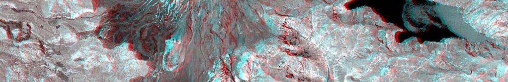
16 This 3 D anaglyph image of Mt. St. Helens volcano. Use 3D glasses! ucation/teachers corner/library/nasaaster series.shtml NASA Source


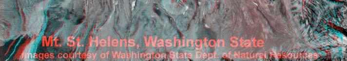
17 This 3 D anaglyph image of Mt. St. Helens volcano. Use 3D glasses! s/places/ger_msh_anaglyph175.jpg
18 Mt. Saint Helens Resources A Volcano Rekindled: The Renewed Eruption of Mount St. Helens, Rebuilding Mount St. Helens / / / / A New Perspective on Mount St. Helens Dramatic Landform Change and Associated Hazards at the Most Active Volcano in the Cascade Range Historic Digital Elevation Models (DEMs) USGS Fact Sheet: Mount St. Helens From the 1980 Eruption to / Geologic Map of the Sasquatch Steps Area, North Flank of Mount St. Helens, Washington map/i2463/ 360 Panoramic View of Mount St. Helens Crater Mt St Helens.html /f /f Teacher s Corner Mt. Saint Helens National Volcanic Monument corner/library/nasa aster series.shtml Mount St Helens National Volcanic Monument Mount St. Helens National Volcanic Monument
The Ongoing Eruption of Mount St. Helens* By Thomas C. Pierson 1
 The Ongoing Eruption of Mount St. Helens* By Thomas C. Pierson 1 Search and Discovery Article #50042 (2007) Posted May 12, 2007 *Abstract of presentation to Tulsa Geological Society, April 24, 2007, followed
From Punchbowl to Panum: Long Valley Volcanism and the Mono-Inyo Crater Chain
 From Punchbowl to Panum: Leslie Schaffer E105 2002 Final Paper Long Valley Volcanism and the Mono-Inyo Crater Chain Figure 1. After a sequence of earthquakes during the late 1970 s to the early 1980 s
Igneous Rock Notes. Page #:
 Page #: Igneous Rock Notes Magma and lava form very different types of igneous rocks. Igneous rocks form from molten rock, but where does molten rock come from? The temperature inside Earth with depth.
Posteruption glacier development within the crater of Mount St. Helens, Washington, USA
 Quaternary Research 61 (2004) 325 329 Short Paper Posteruption glacier development within the crater of Mount St. Helens, Washington, USA Steve P. Schilling, a, * Paul E. Carrara, b Ren A. Thompson, b
Case History: Mt. St. Helens
 Case History: Mt. St. Helens EAS 458 Volcanology Introduction 1980 eruption of Mt. St. Helens was particularly interesting and violent eruption with an unusual lateral blast. In the 1970 s, the USGS (Crandell(
GEOL1 Physical Geology Laboratory Manual College of the Redwoods Lesson Five: Volcanoes Background Reading: Volcanoes Volcanic Terms: Silca:
 Name: Date: GEOL1 Physical Geology Laboratory Manual College of the Redwoods Lesson Five: Volcanoes Background Reading: Volcanoes Volcanic Terms: Silca: SiO 2 silicon dioxide. This is quartz when it crystallizes.
Volcanoes. Table of Contents Volcanoes and Plate Tectonics Volcanic Eruptions Volcanic Landforms
 Volcanoes Table of Contents Volcanoes and Plate Tectonics Volcanic Eruptions Volcanic Landforms What is a volcano? cone Conduit Or Pipe vent Side vent Central vent Crater A volcano is a vent or 'chimney'
Mt St Helens was know to have entered into active periods that lasted from years once every years over the last 500 years, (Figure 5).
.") Lecture #8 notes; Geology 3950, Spring 2006; CR Stern May 1980 eruption of Mt St Helens volcano (text pages 183-192 in the 4 th edition and 206-222 in the 5 th edition) Mt St Helens in southwest Washington
Lecture #8 notes; Geology 3950, Spring 2006; CR Stern May 1980 eruption of Mt St Helens volcano (text pages 183-192 in the 4 th edition and 206-222 in the 5 th edition) Mt St Helens in southwest Washington
GEOLOGY 285: INTRO. PETROLOGY
 Dr. Helen Lang Dept. of Geology & Geography West Virginia University FALL 2005 GEOLOGY 285: INTRO. PETROLOGY Mount St. Helens 1980 Eruption Small earthquakes Small steam and ash eruptions in March and
Part I. Mt. St. Helens
 Name: Date: This contains material adapted from Richard Abbot (Appalachian State University, Department of Geology) and from the USGS Volcanoes! 1997 Teacher packet. Part I. Mt. St. Helens In the illustration
Pyroclastic Flows. Lesson 6
 Pyroclastic Flows Lesson 6 P yroclastic flows are one of the most dangerous natural events that occur on our planet. They can at hurricane speeds down the slopes of a mountain, destroying everything in
Volcanoes. 11/25/2013. Geology 15 Lecture 27 VOLCANO!
 Hazard Update Surprise POP Review Tsunami Activity 10 B Today s Material Volcanoes Volcanic Hazards Geology 15 Lecture 27 VOLCANO! http://motherboard.vice.com/blog/watch an erupting volcano create a newisland
Kilauea Volcano in Eruption on Postals
 June 2018 Kilauea Volcano in Eruption on Postals Webfooters Post Card Club PO Box 17240 Portland OR 97217-0240 www.thewebfooters.com Kilauea Volcano in Eruption on Postals By David A Anderson We are currently
Earth s Dynamic Surface
 Earth s Dynamic Surface Shaping Earth s Surface What do you think? Read the two statements below and decide whether you agree or disagree with them. Place an A in the Before column if you agree with the
Images from: Boston.com
 Images from: Boston.com Ireland in the shadow of a volcano: Understanding the 2010 eruption at Eyjafjallajökull, Iceland. Chris Bean, School of Geological Sciences, UCD. World Quakes and Volcanoes 1960-2010
A physical feature of the Earth s surface
 Earth s Landforms A physical feature of the Earth s surface A physical feature of the Earth s surface LANDFORM Highest of Earth s physical features Highest of Earth s physical features MOUNTAIN Low area
When volcanoes erupt, magma is released. Where does this
 38 Beneath the Earth s Surface R E A D I N G When volcanoes erupt, magma is released. Where does this magma come from? To answer this question, it helps to know more about the earth. Imagine taking a glass
Why was this eruption important?
 Mount St. Helens Mount St. Helens has a long geological history (>3,000 yrs) of explosive eruptions. The 1980 Events: Initial relatively mild steam and ash (Vulcanian) eruptions. Sustained plinian eruption
GEOL 10: Environmental Geology Activity 9: Topographic Maps and Mt. St. Helens. Name: Date:
 GEOL 10: Environmental Geology Activity 9: Topographic Maps and Mt. St. Helens Name: Date: A topographic map is a two dimensional (flat) representation (model) of a three dimensional land surface (landscape).
Apr 20 2:26 PM. the opening in Earth's crust through which molten rock, gases, and ash erupt. the landform that develops around this opening
 Volcanoes Cleveland Volcano, Alaska, May 2006 Taken from the ISS Apr 20 2:26 PM The term volcano can refer to two things: 1. the opening in Earth's crust through which molten rock, gases, and ash erupt
A New College in Orting?
 A New College in Orting? Risk Report and Recommendation by: Safe Schools Kause Everyone Deserves (SSKED) 2017 Geographic location and physical site of Orting The city of Orting is located in Pierce county,
Volcanoes Shake and Bake Indoor Activity
 Mount St Helens National Volcanic Monument Teacher s Corner 2011 Gifford Pinchot National Forest USDA Forest Service Volcanoes Shake and Bake Indoor Activity Time Commitment: Trail: Location: 45 minutes
Mount Pinatubo and the Ring of Fire
 Mount Pinatubo and the Ring of Fire Mount Pinatubo and the Ring of Fire On July 16, 1990, a large earthquake struck Luzon, an island in the Philippines. The earthquake devastated cities for hundreds of
Magma vs. Lava. Molten rock below Earth s surface is called magma. The magma that reaches the surface and erupts out of a volcano is called lava.
 CH. 10.1 Be able to Explain the factors that determine the type of volcanic eruption. List the 3 types of volcanoes Describe the features of a volcano. What is a Volcano? Volcanoes are sites where molten
Plate Tectonics. Chapter 8
 Plate Tectonics Chapter 8 Vocabulary Crust Mantle Core Lithosphere Continental Drift Plate Tectonics Plate Boundary Fault What Are The Earth s Layers Made Of? Atmosphere: Contains nitrogen, oxygen, carbon
3/24/2016. Geology 12 Mr. M. Gauthier 24 March 2016
 Geology 12 Mr. M. Gauthier 24 March 2016 Introduction: Mt. St. Helens Before 1980 Mt. St Helens, in Southern Washington State, had not erupted since 1857 On March 27,1980 minor ashand eruptions were due
Chapter 18. Volcanism
 Chapter 18 Volcanism Ring of fire contains 66% of world s active volcanoes Convergent : Divergent: Icelandic Eruption Mount Etna Different Kinds of eruptions: Volcanic activity is controlled by plate tectonics,
Orting Community College Proposal
 Orting Community College Proposal Cedric, Celina, Francine, Sarah, Samuel GEO CORP Located in Washington, 42 miles south of Seattle. Situated between two rivers on fertile plains. Built on lahar deposits.
4 Deforming the Earth s Crust
 CHAPTER 7 4 Deforming the Earth s Crust SECTION Plate Tectonics BEFORE YOU READ After you read this section, you should be able to answer these questions: What happens when rock is placed under stress?
Basalt Dikes at Schoodic Point, Acadia National Park
 Maine Geologic Facts and Localities November, 2004, Acadia National Park 44 o 19 58.26 N, 68 o 3 39.40 W Text by Henry N. Berry, Department of Agriculture, Conservation & Forestry 1 Introduction Among
Convergent Plate Boundary Geologic Features
 Convergent Plate Boundary Geologic Features Ocean Trench Mtn / Volcano New Ocean Crust Old Continenta l Crust Beadle, 2009 Convection cells provide the force to move the continents. The crust is carried
Collision and transform Boundaries
 Collision and transform Boundaries I. The collision boundary Sometimes when two plates move together they are both continental rather than one being continental and one being oceanic as at the destructive
What Are Tectonic Plates?
 Plate Tectonics The theory that the Earth s outermost layer is fragmented into a dozen or more large and small plates that move relative to one another as they ride on top of hotter, more mobile material.
A Volcano is An opening in Earth s crust through
 Volcanoes A Volcano is An opening in Earth s crust through which molten rock, gases, and ash erupt. Also, the landform that develops around this opening. Kinds of Eruptions Geologists classify volcanic
Directed Reading. Section: Volcanic Eruptions. light in color is called a. felsic. b. oceanic. c. mantle. d. mafic. dark in color is called
 Skills Worksheet Directed Reading Section: Volcanic Eruptions 1. Lava provides an opportunity for scientists to study a. the nature of Earth s inner core. b. the nature of Earth s tectonic plates. c. temperatures
1. minerals - A naturally occurring substance that takes a solid Crystal form and is made of only a single (one) type of compound
 type of compound") Science Name: Mr. G/Mrs. Kelly KEY Date: Study Guide - Lessons 5 and 6 Test Define the following terms: 1. minerals - A naturally occurring substance that takes a solid Crystal form and is made of only
Science Name: Mr. G/Mrs. Kelly KEY Date: Study Guide - Lessons 5 and 6 Test Define the following terms: 1. minerals - A naturally occurring substance that takes a solid Crystal form and is made of only
Name: Geology Study Guide Date:
 Name: Geology Study Guide Date: Vocabulary You must know the following terms and definitions: 1. bedrock- a solid rock mass that is undisturbed by environmental conditions on the Earth s crust 2. Continental
GEOL 02: Historical Geology Lab 14: Topographic Maps. Name: Date:
 GEOL 02: Historical Geology Lab 14: Topographic Maps Name: Date: A topographic map is a two dimensional (flat) representation (model) of a three dimensional land surface (landscape). It shows landforms
3/7/17. #16 - Case Studies of Volcanoes II. Announcements Monday 2/27
 Announcements Monday 2/27 Exam #1: Monday Feb. 27 th, 7:15-8:15 (see web site) Last Names A - N Loomis 141 Last Names O - Z Loomis 151 Bring your student ID An old exam is posted in Compass If you are
Constructive & Destructive Forces
 Constructive & Destructive Forces Intro: Constructive Forces Processes that create landforms. Destructive Forces Processes that destroy landforms. Intro: Constructive Forces Volcanoes Deposition Landslides
Module 1, Investigation 3: Predicting Eruptions
 Module 1, Investigation 3: Predicting Eruptions Introduction Welcome! Volcanoes are either "active" or "extinct". Active means that the volcano has erupted during the past 10,000 years. It can also mean
COSMORPHOLOGY - May 2009
 Name COSMORPHOLOGY - May 2009 Geologic landforms Purpose: By studying aerial photographs you will learn to identify different kinds of geologic features based on their different morphologies and learn
Study Guide: Unit 3. Density and Pressure: You should be able to answer the types of questions given in the end of module questions.
 IDS 102 Study Guide: Unit 3 The purpose of this study guide is to help you prepare for the third exam by focusing your studying and providing example essay questions. In the Focus On section you will find
Activity Pacific Northwest Tectonic Block Model
 Activity Pacific Northwest Tectonic Block Model The Cascadia tectonic margin is caught between several tectonic forces, during the relentless motions of the giant Pacific Plate, the smaller subducting
PLATE TECTONICS REVIEW GAME!!!!
 PLATE TECTONICS REVIEW GAME!!!! Name the four layers of the earth - crust - mantle - outer core - inner core Which part of Earth s structure contains tectonic plates? LITHOSPHERE Name one reason why the
EAS 116 Earthquakes and Volcanoes
 EAS 116 Earthquakes and Volcanoes J. Haase Forecasting Volcanic Eruptions Assessment of Volcanic Hazard Is that volcano active? Mount Lassen: 12000 BP and 1915 Santorini, IT: 180,000 BP, 70,000 BP, 21000
NSF-MARGINS Expedition to Anatahan Volcano March 2005
 1 NSF-MARGINS Expedition to Anatahan Volcano March 2005 According to the Emergency Management Office (EMO) report distributed in February 2005, the third historical eruption of Anatahan began on January
1 Types of Volcanoes CHAPTER. Chapter 1. Types of Volcanoes
 CHAPTER 1 Types of Volcanoes Describe the magma compositions and characteristics of different types of volcanoes. What does an active volcano look like? Climbing up Mount St. Helens and looking into the
Unit 4 Lesson 4 Volcanoes. Copyright Houghton Mifflin Harcourt Publishing Company
 Magma Magic What is a volcano? A volcano is any place where gas, ash, or melted rock come out of the ground. Many volcanoes are dormant, meaning an eruption has not occurred in a long period of time. What
Name: Page 1. 2) What do increases and decreases in RSAM data indicate about magma movement inside the volcano?
 What do increases and decreases in RSAM data indicate about magma movement inside the volcano?") Name: Page 1 Living on the Edge Unit 5: SEISMOLOGISTS A report on the seismic activity must be prepared in order to assess and forecast future activity. Complete the following components of the seismology
Name: Page 1 Living on the Edge Unit 5: SEISMOLOGISTS A report on the seismic activity must be prepared in order to assess and forecast future activity. Complete the following components of the seismology
Investigation 3: Predicting Eruptions
 Investigation 3: Predicting Eruptions Table of Contents Folder 1: Seismic Activity... 23 Folder 2: Ground Deformation (Mount St. Helens, Washington)... 25 Folder 3: Hot Spots... 26 Folder 4: Gas Emissions...
VOLCANO MONITORING PRACTICAL. Hazard alert levels established for communication at Mt. Pinatubo
 VOLCANO MONITORING PRACTICAL Predicting volcanic eruptions is a hazardous and stressful business. If an eruption has occurred and was not predicted then the volcanologists get the blame for not giving
GEOLOGY 285: INTRO. PETROLOGY
 Dr. Helen Lang Dept. of Geology & Geography West Virginia University SPRING 2015 GEOLOGY 285: INTRO. PETROLOGY The Cascade Volcanoes are a good example of the Circum- Pacific ring of fire of subductionrelated
Subaerial Felsic Lava Flows and Domes
 Subaerial Felsic Lava Flows and Domes Occurrence Alone or in linear and arcuate chains up to 20 km long Margins of calderas or volcanic depressions. Feeder occupies synvolcanic fault (ring fracture). Extrusion
Objectives: Describe how volcanoes can affect people. Describe conditions that cause volcanoes. Describe the relationship between volcanoes and Earth
 Objectives: Describe how volcanoes can affect people. Describe conditions that cause volcanoes. Describe the relationship between volcanoes and Earth s moving plates. Inside of Old Smokey, All covered
A bowl shaped depression formed by the collapse of a volcano is called a. Magma that has left the vent of a volcano is known as. Lava.
 Magma that has left the vent of a volcano is known as Lava A bowl shaped depression formed by the collapse of a volcano is called a Caldera This can form in a caldera when magma starts to come back up
The map below shows the locations of earthquakes and volcanoes
 45 Understanding Plate Boundaries R EA D I N G The map below shows the locations of earthquakes and volcanoes on the earth s surface. Today, many of the world s most active volcanoes are located around
Effects of Eruptions. Most active in the world Kilauea, Hawaii.
 Inside of Old Smokey, All covered with snow, Lurk tons of hot magma, Getting ready to blow, Objectives: From deep in the chamber, Describe how volcanoes can affect people. Up a vent to the top, Describe
A mantle B magma C core D crust
 CHANGING LANDFORMS Book Quiz Directions: Read each question and choose the best answer. 1. Which of the following are examples of landforms? A mountains and canyons B cliffs and sand dunes C volcanoes
Social Studies. Chapter 2 Canada s Physical Landscape
 Social Studies Chapter 2 Canada s Physical Landscape Introduction Canada s geography its landforms and climate - has a great impact on Canadians sense of identity. Planet Earth The earth is divided into
Homework III. Volcanological Exercises
 Page 1 of 5 EENS 3050 Tulane University Natural Disasters Prof. Stephen A. Nelson Homework III. Volcanological Exercises This page last updated on 16-Feb-2018 1. In your work as an insurance company executive
Volcanism (Chapter 5)
") GEOLOGY 306 Laboratory Instructor: TERRY J. BOROUGHS NAME: Volcanism (Chapter 5) For this assignment, you will require: a calculator, colored pencils, string, protractor, stereoscopes (provided). Objectives
GEOLOGY 306 Laboratory Instructor: TERRY J. BOROUGHS NAME: Volcanism (Chapter 5) For this assignment, you will require: a calculator, colored pencils, string, protractor, stereoscopes (provided). Objectives
Plate Tectonics and fun Earth Stuff
 Plate Tectonics and fun Earth Stuff Set Up - 1 large graham cracker - 2 3-in squares of fruit roll up - 1 cup of water - Frosting/cool whip - Wax paper or plate - Plastic spoon http://learningplatetectonics.weebly.com/activity.html
Erosional Features. What processes shaped this landscape?
 Have you ever looked at the land around you and wondered what processes shaped what you see? Perhaps you see mountains, valleys, rivers, or canyons. Do you know how long these geologic features have been
Landforms from Volcanoes
 Landforms from Volcanoes Lesson Concept Link Volcanoes are classified by how they are formed (quiet or explosive eruption) and the resulting land formation (shield, cinder cone, or composite/stratovolcano).
Debris Avalanches. Debris avalanche deposits on a volcano in Chile. All of the area in the foreground is buried by a thick debris avalanche.
 Debris Avalanches Volcanoes are not very stable structures. From time to time, they collapse producing large rock and ash avalanches that travel at high speeds down valleys. Collapse maybe caused by an
Volcanoes. Presented by Kesler Science
 Presented by Kesler Science Essential Questions: 1. What are the parts of a volcano? 2. What are the four types? 3. What processes form volcanoes? 4. Where are volcanoes located on earth? What is a Volcano?
Released Science Inquiry Task Encounter with an Active Volcano Grade 11
 Date: Your Name: Released Science Inquiry Task Encounter with an Active Volcano 2016 Grade 11 Directions: Science You will be reading a story and analyzing the data provided to answer a set of questions.
Earth Structures and Processes Teacher Notes
 Aleutian Islands String of islands resulting from volcanic activity Part of the Pacific Ring of Fire Coast is very jagged and rocky with steep cliffs and mountains Underwater eruptions form new landforms
The Bishop Tuff. Leah French COAS E105: Volcanoes of the Sierra Nevada
 The Bishop Tuff Leah French COAS E105: Volcanoes of the Sierra Nevada Photo by Leah French (Michael Hamburger and Adam Schau walk through the Bishop Tuff in the Owens River Gorge) Location: 37.6N, 118.8W
EHaz 26 April 2007 Questions. The following questions are arranged by topic. Risk assessment & management MTU
 EHaz 26 April 2007 Questions The following questions are arranged by topic. Risk assessment & management Slide 17 (very good slide, by the way!): In the case of the Merapi and Mt. St. Helens crises, how
Plate Tectonics Unit II: Plate Boundaries (3.5 pts)
") T. James Noyes, El Camino College Plate Tectonics Unit II: The Plate Boundaries (Topic 11A-2) page 1 Name: Section: Plate Tectonics Unit II: Plate Boundaries (3.5 pts) Plate Boundaries We will now discuss
T. James Noyes, El Camino College Plate Tectonics Unit II: The Plate Boundaries (Topic 11A-2) page 1 Name: Section: Plate Tectonics Unit II: Plate Boundaries (3.5 pts) Plate Boundaries We will now discuss
Get in Touch with Tapasvi IAS
 Barren Island Volcano Erupted Again, Facts About Barren Island Get in Touch with Tapasvi IAS Join us on Facebook for daily updates and important material for UPSC Join Now Join our Telegram Channel and
Lava from Hawaiian volcano eruptions creeps into communities
 Lava from Hawaiian volcano eruptions creeps into communities By Associated Press, adapted by Newsela staff on 05.09.18 Word Count 657 Level 850L In this May 5, 2018, photo provided by U.S. Representative
Lava from Hawaiian volcano eruptions creeps into communities
 Lava from Hawaiian volcano eruptions creeps into communities By Associated Press, adapted by Newsela staff on 05.09.18 Word Count 657 Level 860L In this May 5, 2018, photo provided by U.S. Representative
East Penn School District Curriculum and Instruction
 East Penn School District Curriculum and Instruction Curriculum for: Geology of National Parks Course(s): Geology of the National Parks Grades: 10-12 Department: Science Length of Period (average minutes):
Chapter 2 Geography. Getting to know Earth
 Chapter 2 Geography Getting to know Earth Our Solar System Sun is at the center of our solar system Contains a lot of Mass» Mass gives the Sun gravitational pull» This keeps the planets in our solar system
EROSIONAL FEATURES. reflect
 reflect Have you ever looked at the land around you and wondered what processes shaped what you see? Perhaps you see mountains, valleys, rivers, or canyons. Do you know how long these geologic features
Erupted and killed approximately 15,000 people 200 years ago
 1 2 3 4 5 6 7 8 Introduction to Environmental Geology, 5e Chapter 8 Volcanic Activity Volcanoes: summary in haiku form A volcano forms. Magma comes to the surface - explodes, if felsic. Case History: Mt.
Volcanoes. Environmental Geology, Mr. Paul Lowrey Stacey Singleton, Cassandra Combs, Dwight Stephenson, Matt Smithyman
 Volcanoes Environmental Geology, Mr. Paul Lowrey Stacey Singleton, Cassandra Combs, Dwight Stephenson, Matt Smithyman EMPACTS Project, Spring 2017 Northwest Arkansas Community College, Bentonville, AR
Multiple Choice Identify the letter of the choice that best completes the statement or answers the question.
 volcano sample test Multiple Choice Identify the letter of the choice that best completes the statement or answers the question. 1. Volcanic belts form along a. islands in the Pacific Ocean. b. North American
Unit V Volcanoes. Q-2 Use the scale bar to determine approximately how wide (in miles) Mt. Shasta is at is widest point. miles
 Mt. Shasta is at is widest point. miles") Unit V Volcanoes Name: California Geology Questions 1-9 Figure 1 is a shaded relief map from the USGS showing the area surrounding Mt. Shasta. Mt. Shasta itself is in the center of the map. Note that there
Unit V Volcanoes Name: California Geology Questions 1-9 Figure 1 is a shaded relief map from the USGS showing the area surrounding Mt. Shasta. Mt. Shasta itself is in the center of the map. Note that there
Chapter Introduction Lesson 1 Earthquakes Lesson 2 Volcanoes Chapter Wrap-Up
 Chapter Introduction Lesson 1 Earthquakes Lesson 2 Volcanoes Chapter Wrap-Up What causes earthquakes and volcanic eruptions? What do you think? Before you begin, decide if you agree or disagree with each
Geography Advanced Subsidiary Paper 1
 Pearson Edexcel Level 3 GCE Geography Advanced Subsidiary Paper 1 Sample assessment material for first teaching September 2016 Resource Booklet Paper Reference 8GE0/01 Do not return this Resource Booklet
Volcano: a weak spot in the crust where molten material or magma comes to the surface
 Chapter 7 Volcano: a weak spot in the crust where molten material or magma comes to the surface Magma: a molten mixture of rock forming substances, gases and H 2 O from the mantle Volcanic Belts: Form
A Living Planet. Chapter PHYSICAL GEOGRAPHY. What you will learn in this chapter. Summary of the chapter
 QUIT Main Ideas What you will learn in this chapter Summary Summary of the chapter Test your geographic knowledge by playing the. Main Ideas Section 1: The Earth Inside and Out The earth is the only habitable
Folding. Faulting. Volcanoes
 Folding Faulting Volcanoes Most major global mountain ranges were formed by the collision of continental (tectonic) plates Fold mountains are actually formed by crust which have been uplifted and folded
68. Izu-Torishima. Summary. Latitude: 30 29'02" N, Longitude: '11" E, Elevation: 394 m (Ioyama) (Elevation Point) (68.
 (Elevation Point) (68.") 68. Izu-Torishima Latitude: 30 29'02" N, Longitude: 140 18'11" E, Elevation: 394 m (Ioyama) (Elevation Point) Izu-Torishima taken from southeast side on August 12, 2002. Courtesy of the Maritime Safety
68. Izu-Torishima Latitude: 30 29'02" N, Longitude: 140 18'11" E, Elevation: 394 m (Ioyama) (Elevation Point) Izu-Torishima taken from southeast side on August 12, 2002. Courtesy of the Maritime Safety
History of the Long Valley Caldera Abstract The history of the Long Valley Caldera is an active one that began 280 ma years before
 Alicia Pardoski 1 History of the Long Valley Caldera Abstract The history of the Long Valley Caldera is an active one that began 280 ma years before present with the building and eruption of Glass Mountain.
Supporting the response to the 2018 lower East Rift Zone and summit collapse at Kīlauea Volcano, Hawaiʻi
 Hawaiʻi Supersite success story Supporting the response to the 2018 lower East Rift Zone and summit collapse at Kīlauea Volcano, Hawaiʻi Since 1983, Kīlauea Volcano, on the Island of Hawaiʻi, has actively
Read Across America. Listen as I read for facts about Volcanoes. In the Shadow of the Volcano
 Read Across America Listen as I read for facts about Volcanoes. In the Shadow of the Volcano Constructive & Destructive Processes Earth s surface is always changing. Blowing wind and flowing water causes
SEISMIC DATA SET 2 (THROUGH JUNE 12)
") Living on the Edge: Unit 6 Prework, Hazards and Risks at Convergent Plate Boundaries SEISMIC DATA SET 2 (THROUGH JUNE 12) Note: you only need to examine/describe the same type of data you used during the
Living on the Edge: Unit 6 Prework, Hazards and Risks at Convergent Plate Boundaries SEISMIC DATA SET 2 (THROUGH JUNE 12) Note: you only need to examine/describe the same type of data you used during the
Chapter 7: Volcanoes 8/18/2014. Section 1 (Volcanoes and Plate Tectonics) 8 th Grade. Ring of Fire
 8 th Grade. Ring of Fire") Section 1 (Volcanoes and Plate Tectonics) Chapter 7: Volcanoes 8 th Grade Ring of Fire a major belt of es that rims the Pacific Ocean Volcanic belts form along the boundaries of Earth s plates as they
Section 1 (Volcanoes and Plate Tectonics) Chapter 7: Volcanoes 8 th Grade Ring of Fire a major belt of es that rims the Pacific Ocean Volcanic belts form along the boundaries of Earth s plates as they
Prentice Hall EARTH SCIENCE
 Prentice Hall EARTH SCIENCE Tarbuck Lutgens Chapter 9 Plate Tectonics 9.1 Continental Drift An Idea Before Its Time Wegener s continental drift hypothesis stated that the continents had once been joined
Prentice Hall EARTH SCIENCE
 Prentice Hall EARTH SCIENCE Tarbuck Lutgens Chapter 9 Plate Tectonics 9.1 Continental Drift An Idea Before Its Time Wegener s continental drift hypothesis stated that the continents had once been joined
A. What is a volcano?
 VOLCANISM THE ROCK CYCLE I. Introduction From: Roman god of fire, Vulcan A. What is a volcano? A conical mountain formed around a vent where lava, pyroclastic materials, and gases are erupted. I. Introduction
12.2 Plate Tectonics
 12.2 Plate Tectonics LAYERS OF THE EARTH Earth is over 1200 km thick and has four distinct layers. These layers are the crust, mantle (upper and lower), outer core, and inner core. Crust outer solid rock
Lidar Illustrated 2012 CALENDAR OREGON DEPARTMENT OF GEOLOGY AND MINERAL INDUSTRIES
 Lidar Illustrated 2012 CALENDAR OREGON DEPARTMENT OF GEOLOGY AND MINERAL INDUSTRIES Lidar Technology & Coverage in Oregon DOGAMI APPLICATIONS FOR HIGH-RESOLUTION LIDAR IMAGE: USGS Lidar (light detection
Fire and Ice. Overview. Grade Level 6 8. Students will be able to: Objectives
 Fire and Ice Overview Students use a power point presentation to compare and contrast the geologic history and environment of Mount Rainier and Mount Fuji, the Sister Mountains. Grade Level 6 8 Students
General Oceanography Geology 105 Expedition 8 Plate Boundaries Beneath the Sea Complete by Thursday at 11:00 PM
 General Oceanography Geology 105 Expedition 8 Plate Boundaries Beneath the Sea Complete by Thursday at 11:00 PM Name Expedition Objectives Learn about the types of plate boundaries and their key characteristics