Pacific Islands Regional Maritime Boundaries Project
|
|
|
- Alexia Hoover
- 5 years ago
- Views:
Transcription

1 Pacific Islands Regional Maritime Boundaries Project Presented By Filimoni Yaya (Andrick Lal, Sachindra Singh, Emily Artack) Geoscience Division Pacific Community (SPC Geoscience Division, GSD STAR Sessions, 26 th 29 th June 2017 Nadi, Tanoa International Hotel
2 Regional Maritime Boundaries Project background Started in the late 1990s under the fisheries programme at Forum Fisheries Agency (FFA) based in Honiara, Solomon Islands Governing Council agreed to transfer the Project to the South Pacific Applied Geoscience Commission (SOPAC) in 2000 Project was funded by the Government of Australia Project staff: 1 Technical officer (Full time) + 1 Senior Surveyor (Part-time) + 1 GIS Assistant (Full time) + 1 ITSpecialist (Part-time) Project Manager & Programme Administrator


")

3 SPC s Geoscience Division: Regional Maritime Boundaries Unit Activities (2002 to date) (1) Development of baseline and critical base points (2) Maritime zones development
4 Maritime Limits: The Envelope of Arcs Ocean Basepoints G Distance from basepoints A B C F Envelope of arc E D Maritime zone limit Land Irrelevant basepoint Baselines versus Basepoints: Not all of the baseline contributes to defining the limits of maritime jurisdiction
5 Maritime Boundary Computation MarZone PC application, computes maritime boundaries in accordance with the various provisions of UNCLOS Developed by University of Melbourne, under contract to Geoscience Australia Translators have been developed to make it compatible with MapInfo (previously preferred GIS platform of the Pacific region) QGIS is compatible with MarZone


6 Maritime Boundary Computation MarZone Calculates the median line between two countries based on equi-distance ratio

7 MarZone Part 1; Median Line Results Median Line output in log file Median Line is also saved as a line output from MarZone

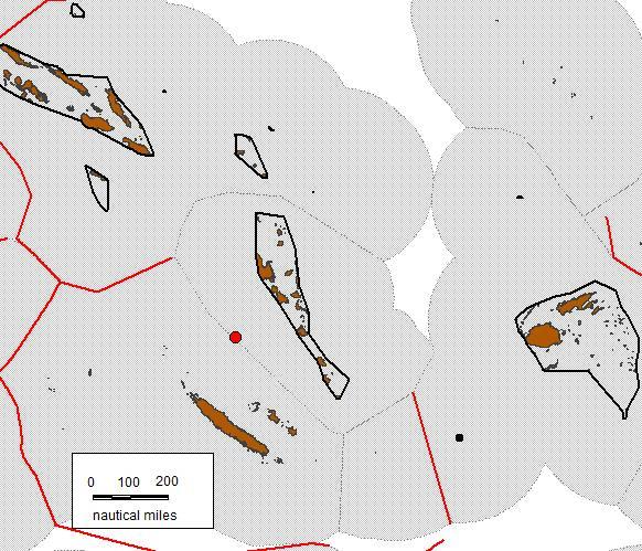
8 Regional Maritime Boundaries Unit (3) Technical solutions prepared with PICs for shared/overlapping EEZs * Not drawn to scale
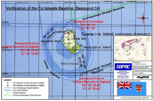
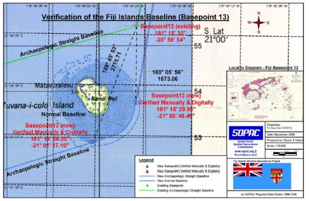
9 Review & Verification Fiji Islands Archipelago

10 Verification of Main Archipelago
11 Treaty development


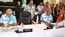
12 Treaty Development (2012) Marshall Islands, Kiribati and Nauru meeting An excellent example of a successful partnerships between regional organisations and testament to the excellent relationships between Pacific Island neighbours.


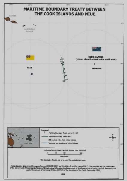
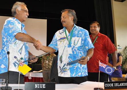
13 Milestone: Signing of the 7 Bilateral Maritime Boundaries, 2012 Forum Meeting NIUE & COOK IS KIRIBATI & COOK IS KIRIBATI & TUVALU KIRIBATI & TOKELAU KIRIBATI & NAURU NAURU & MARSHALL IS KIRIBATI & MARSHALL IS KIRIBATI NAURU-MARSHALL IS
 Technical")


14 USA FSM Maritime Boundary negotiations (2014) Technical and legal meeting hosted by the US in Hawaii in April 2014 (FSM team officials travel costs were supported by the Forum Fisheries Agency)
15 SPC Maritime Boundaries Project Regional Maritime Boundaries Unit within the Geoscience Division has operated since 2001, and is widely recognised as driving a successful international collaborative effort to fulfil one of the region s key strategic priorities embedded in the Pacific Oceanscape Framework (endorsed by the Pacific Island Leaders in 2010) which is to formalise maritime boundaries and securing rights over ocean resources as the first regional priority. In the Pacific region, there are 50 shared and overlapping Exclusive Economic Zones (EEZs), so there is a need for PICs to negotiate and delimit their own EEZs where it overlaps with its neighbouring countries zones as well. Core Functions of the Project Provide maritime boundaries delimitation data and information for the member countries to assist in preparation of claims for delimitation of their Exclusive Economic Zones; Develop comprehensive data-sets which facilitate definition of the legal and administrative offshore limits for member countries, in accordance with the provisions of UNCLOS; Build national capacity within member countries to undertake these assessments; Provide advice and assistance to member countries on relevant provisions of UNCLOS; Act as an information and data repository.

16 Overall Regional progress in implementing UNCLOS and the PICs maritime boundaries 2002

17 Overall Progress Now 2017

18 Status of efforts at regional scale as compared to efforts at the national scale
 Vessel Monitoring System (VMS) to be updated with publicly available and legislated boundaries for the")

 will be")
19 Service Level Agreement with FFA The 2016 SLA underlined the need for the maritime zones lines in the Pacific Islands Forum Fisheries Agency (FFA) Vessel Monitoring System (VMS) to be updated with publicly available and legislated boundaries for the purpose of fisheries monitoring, control, surveillance and enforcement and management. Data delivered will be based on IHO S-121 Maritime Limits and Boundaries Exchange format and will be disseminated via OGC web services in PacGeo portal Full documentation, tools and processes on maritime boundaries i.e. updates and revisions with incorporation of new datasets Features delivered to FFA will be in points, lines and polygons Global dataset(vliz) will be used where there is no treaty or data available

20 Vessel Monitoring System
21 Member Countries Consent Letters for Release of MB Data to FFA Have Nauru - (12, 24, 200) and Treaties Kiribati - (PHX-200,24,12) (GIL-200,24,12) (LIN- 12,24,200) and Treaties Have Not Palau - (Provisional EEZ and Treaties) Tuvalu - (12, 24, 200) and Treaties Marshall Islands (12, 24, 200) and Treaties FSM - (Treaties) Solomon Islands (Treaties) Vanuatu - (Archipelagic baseline) Cook Islands - (EEZ- 200, Treaties) Tonga - (Restricted) Fiji (Archipelagic baseline and Treaties) Samoa - (Restricted) Tokelau - (Not a Project Member Country) - Treaties PNG - (Treaties) Niue - (12, 24, 200) and Treaties SPC s Maritime Boundary Unit will not release any data to be used in the Vessel Monitoring System (VMS) unless permission is given to SPC to release the data in a legally signed document.

22 Official Release Letters to FFA
23 Pacific Islands Regional Maritime Boundary Information System (PIRMBIS) The goal of the project is to increase economic development opportunities and sustainable resource development in Pacific coastal States (PcS) through defining maritime and extended continental shelf boundaries to assert sovereignty and declare sovereign rights and secure access to known and potential economic marine resources Written by Andrick Lal with Emily Artack (technical manual) GA Mr Colin French (maritime boundaries adviser) with financial help from Gov. Australia Support from member countries :Cook Islands, Federated States of Micronesia, Fiji Islands, Kiribati, Marshall Islands, Nauru, Niue, Papua New Guinea, Samoa, Solomon Islands, Tonga, Tuvalu, Vanuatu The design and development of the Pacific Islands Regional Maritime Boundaries Information System (PIRMBIS) in the project led to the establishment of a sound management of the maritime boundaries related data and information. The source data and output data from PIRMBIS is always quality assured and verified.

24 Schematic Diagram of PIRMBIS
 and the online delivery and exchange of information; the need arose for a high precision data format for")

25 Why S-121? Concurrent with the advent of electronic navigation, Geographical Information Systems (GIS) and the online delivery and exchange of information; the need arose for a high precision data format for the exchange of officially recognised maritime limits and boundaries. Such a digital format would enable States to exchange, lodge and distribute their maritime boundaries in a form that would be portable across a number of applications and platforms. The specification s primary function is for States to exchange maritime boundary information in a recognised format, both between States and as the preferred format for lodgement to the United Nations. Furthermore, the format would encourage the development of digital marine spatial data infrastructures to improve all aspects of ocean management. The format will be appropriate for MSDI, GIS and online utilisation.
26 What does S-121 define? 3 Profiles Baselines, Limits and Boundaries: Data Specification and Application Schema Data Product Identification (UUID) Feature and Attribute Types Geographic Feature Types Attribute Values and Validations Mandatory and Optional Values and Validations Coordinate Reference Systems (CRS) Horizontal Geodetic Datum Data Quality, Reliability and Accuracy of Data Geometry: points, curves and surfaces Encoding Only Canada and Australia have started to adopt S-121 so far.

27 Key difference between profiles are categories: S-121 Profiles A. Baselines 1 : Normal baseline 2 : Straight baseline 3 : Archipelagic baseline 4 : River closing line 5 : Bay closing line 6 : Reef closing line B. Zone or Limits C. Boundaries 1 : Delimitation Vertical Jurisdiction 1 : Air Space, Water Column, Seabed, Subsoil 2 : Water Column 3 : Seabed and Sub-soil 1 : Internal Waters 2 : Archipelagic Waters 3 : Coastal Water 4 : Territorial Sea 5 : Contiguous Zone 6 : Exclusive Economic Zone 7 : Continental Shelf

28 Output Format: Geo-JSON Due to attribute field name size and validation required, current desktop GIS formats were not suitable: E.g.: Shapefile Has a 11 character limit for attribute names Multi-feature geometry is not supported Schema-less, validations can not be built in File structure verbosity (multiple files for a single geometry type shp, shx, dbf, prj, cpg, qpj) Binary and closed S-121 specification documents recommends GML (a XML-based, verbose standard) Geo-JSON was adopted for the Pacific S121 Tool because: Single file supports multi-feature type (multi-points, multi-lines and multi-polygons - curves) Human and machine readable Schema defined No limitations in attribute name/value length Internet-bandwidth friendly and open in nature

29 S-121 Data Attribution Tool Post-processes a folder of Shape-files and auto appends S121-specific attributes across the three S121 Profiles - Baseline, Maritime Limits and Maritime Boundaries. Open Source and Cross Platform
 S-121 Geo-JSON : 1.")
30 S-121 Attributed Geo-JSON Output ESRI Shapefiles : 23.1 Mb, 826 Individual Files (~206 layers) S-121 Geo-JSON : 1.8 Mb, Single File


31 Cook Islands Official Boundary 1km Current VMS EEZ 2km 6km
")

32 Kiribati (Line Island Group) 36km Official EEZ 11km 4km Current VMS EEZ
33 Why is it important? The clear definition of the limits of the maritime jurisdiction is important as it provides the legal framework for the governance of maritime space and the management of the valuable marine resources within the country s national jurisdiction areas: Fisheries management Deep sea minerals development Security Biodiversity Conservation Research Transport Vessel monitoring
34 Fisheries management

35 Future threats to regional peace & security
36 Issues Requires the political will and support of National Governments (ground work has taken the past 10 years of this project) There are certain technical and legal capacity constraints within the project teams (trained staff get promoted internally) Sovereign issue but it is heavily dependent on regional support and assistance (cost of field surveys to collect data, purchase of satellite imagery, etc.) National Maritime Laws and Legislation needs to be reviewed and updated to reflect the technical datasets being used to develop the baselines and maritime zones The 10 project countries who have submitted their claims for Extended Continental Shelf (under Article 76 of UNCLOS) are facing capacity constraints in the process of the defence of the these claims to the UN.
 in a legal manner and deposit this information with")
37 Future Challenges Increasing reports of IUU fishing activities in the region Leaders need to formally establish their maritime boundaries (including signed treaties for overlapping EEZs) in a legal manner and deposit this information with the UN.


38 Future Challenges Deep Sea Mining Implications Application and approval of mining leases for seabed exploration and exploitation within a country s EEZ and also in the Area
 SPC, GA, Australia AG Dept.")


 round of")
39 Regional support for remaining Negotiations (13 shared EEZs yet to be finalised) SPC, GA, Australia AG Dept. & Advisor visited Palau in March 2015 for a national consultation workshop. Outcome was to develop a strategy paper for the national taskforce to consider in upcoming negotiations. SPC & FFA provided technical & legal assistance to the delegation from Palau during the fourth (4 th ) round of negotiations between Palau and Indonesia in July 2015.


40 Countries and Project Partners


41 Thank You
Pacific Islands Regional Maritime Boundaries Project
 Pacific Islands Regional Maritime Boundaries Project 31 st Star Conference, Nadi, FIJI 6-8 June 2016 Jens Kruger Head of Ocean & Coastal Geoscience Sector Andrick Lal Project Officer (Surveying) Emily
Pacific Islands Regional Maritime Boundaries Project the latest Update. Malakai Vakautawale (Mr) Maritime Boundaries Adviser
 Maritime Boundaries Adviser") Pacific Islands Regional Maritime Boundaries Project the latest Update Malakai Vakautawale (Mr) Maritime Boundaries Adviser Consortium Partners 2 What we do? Provide technical advice and support on MB
Pacific Islands Regional Maritime Boundaries Project the latest Update Malakai Vakautawale (Mr) Maritime Boundaries Adviser Consortium Partners 2 What we do? Provide technical advice and support on MB
Briefing document of the status of maritime boundaries in Pacific island countries
 Secretariat of the Pacific Community Seventh Heads of Fisheries Meeting (28 Feb. 4 March 2011, Noumea, New Caledonia) Working Paper 5 Original: English Briefing document of the status of maritime boundaries
Niue Maritime Boundaries Delimitation Project. Christchurch FIGMM
 Niue Maritime Boundaries Delimitation Project Christchurch FIGMM 30 th April 6 th May 2016 Hubert Mana Kalauni Secretary for Justice Department of Justice, Lands and Survey Ministry of Social Services
Pacific Geospatial and Surveying Council (PGSC) Geospatial and GNSS CORS Infrastructure Forum. Kuala Lumpur October
 Geospatial and GNSS CORS Infrastructure Forum. Kuala Lumpur October") Pacific Geospatial and Surveying Council (PGSC) Geospatial and GNSS CORS Infrastructure Forum. Kuala Lumpur 16-17 October Beginning and Progress Members PGSC Charter PGSC Strategy 2017-2027 Meetings Geodetic
Pacific Geospatial and Surveying Council (PGSC) Geospatial and GNSS CORS Infrastructure Forum. Kuala Lumpur 16-17 October Beginning and Progress Members PGSC Charter PGSC Strategy 2017-2027 Meetings Geodetic
Faatasi Malologa (PGSC Chair) Director Department of Lands & Survey, Tuvalu
 Director Department of Lands & Survey, Tuvalu") Seventh Session of the United Nations Committee of Experts on Global Geospatial Information Management (UN-GGIM) - 31 July -4 August 2017 Faatasi Malologa (PGSC Chair) Director Department of Lands & Survey,
Seventh Session of the United Nations Committee of Experts on Global Geospatial Information Management (UN-GGIM) - 31 July -4 August 2017 Faatasi Malologa (PGSC Chair) Director Department of Lands & Survey,
Clive Schofield * and David Freestone **
 Holding Back the Waves: Options to Secure Maritime Jurisdictional Claims in the Face of Sea Level Rise Clive Schofield * and David Freestone ** *Australian National Centre for Ocean Resources and Security
Monitoring Surveys PSLMP COSPPac
 Monitoring Surveys PSLMP COSPPac Andrick Lal, Marika Kalouniviti & Veenil Rattan Science, Technology And Resources (STAR) Conference 26 th 29 th June 2017 Nadi FIJI Geodetic Survey Unit (SPC) Andrick Lal,
Positioning in the Pacific Islands
 Positioning in the Pacific Islands Andrick Lal United Nations/Nepal Workshop on the Applications of Global Navigation Satellite Systems Kathmandu - Nepal 15 th December 2016 Presentation Outline Introduction
NUKU ALOFA MINISTERIAL DECLARATION For SUSTAINABLE WEATHER AND CLIMATE SERVICES FOR A RESILIENT PACIFIC. 24th July 2015, Nuku alofa, Tonga
 NUKU ALOFA MINISTERIAL DECLARATION For SUSTAINABLE WEATHER AND CLIMATE SERVICES FOR A RESILIENT PACIFIC 24th July 2015, Nuku alofa, Tonga The First Pacific Ministerial Meeting on Meteorology was held on
Current status of operations of Pacific Islands Climate Outlook Forum (PICOF) Alexander Montoro Technical Expert on Climate and Weather Services
 Alexander Montoro Technical Expert on Climate and Weather Services") Current status of operations of Pacific Islands Climate Outlook Forum (PICOF) Alexander Montoro Technical Expert on Climate and Weather Services Secretariat of the Pacific Regional Environment Programme
Current status of operations of Pacific Islands Climate Outlook Forum (PICOF) Alexander Montoro Technical Expert on Climate and Weather Services Secretariat of the Pacific Regional Environment Programme
Applied Geoscience and Technology Division SOPAC. Joy Papao, Risk Information Systems Officer
 Joy Papao, Risk Information Systems Officer Secretariat of the Pacific Community SPC 22 Pacific Island States Head office in Noumea, New Caledonia 2 Regional offices (Pohnpei and Honiara) 600 staff 9 Technical
Economic and Social Council
 United Nations Economic and Social Council Distr.: General 18 July 2016 Original: English Committee of Experts on Global Geospatial Information Management Sixth session New York, 3-5 August 2016 Item 2
STATUS OF MARINE SPATIAL DATA INFRASTRUCTURE
 STATUS OF MARINE SPATIAL DATA INFRASTRUCTURE IN PACIFIC ISLAND COUNTRIES 26 th January, 2016 7 th IHO Marine Spatial Data Infrastructure Working Group Meeting Tokyo Sachindra Singh Senior Geospatial Systems
Requirement for Hydrographic Surveying and Nautical Charting for Small Island Developing States within the South West Pacific Region
 Requirement for Hydrographic Surveying and Nautical Charting for Small Island Developing States within the South West Pacific Region John Maschke September 2013 Overview Welcome Introduction Current Situation
THIRD MEETING OF THE PACIFIC METEOROLOGICAL COUNCIL. Theme: "Sustainable Weather and Climate Services for a Resilient Pacific "
 PMC-3/InformationPaper-1-Provisional Agenda THIRD MEETING OF THE PACIFIC METEOROLOGICAL COUNCIL Theme: "Sustainable Weather and Climate Services for a Resilient Pacific " 20-23 July 2015 Fa'onelua Convention
xxv PART I THE DIVIDED OCEANS: INTERNATIONAL LAW GOVERNING JURISDICTIONAL ZONES 1
 Contents Preface page xv List of Figures xvii List of Tables xviii List of Abbreviations xix Table of Cases xxi Table of Treaties and Instruments xxv PART I THE DIVIDED OCEANS: INTERNATIONAL LAW GOVERNING
Ocean governance in Samoa: A case study of ocean governance in the South Pacific
 Ocean governance in Samoa: A case study of ocean governance in the South Pacific Anama Solofa UN-Nippon Nippon Foundation of Japan Fellowship 2009-2010 2010 Outline: I. Ocean governance in the South Pacific
Deep Sea Minerals in the Pacific Islands Region: Occurrence, Potential and Case Studies`
 Deep Sea Minerals in the Pacific Islands Region: Occurrence, Potential and Case Studies` 1st DSM Project Regional Workshop 6th 8th June 2011 Tanoa International Hotel Nadi, Fiji Akuila Tawake SPC/SOPAC
INTERNATIONAL HYDROGRAPHIC ORGANIZATION
 INRNATIONAL HYDROGRAPHIC ORGANIZATION Maritime Limits and Boundaries Product Specification IHO S-121 Version 1.0 April 2014 Maritime Limits and Boundaries Product Specification Published by the International
A Pacific Regional Economics of Climate Change Study: Assessing adaptation needs in Small Island Developing States
 Regional Economics of Climate Change: Practitioners Workshop 4-5 March 2009 Washington, DC, USA A Pacific Regional Economics of Climate Change Study: Assessing adaptation needs in Small Island Developing
HONIARA MINISTERIAL STATEMENT For STRENGTHENING SUSTAINABLE WEATHER, CLIMATE, OCEAN AND WATER SERVICES FOR A RESILIENT PACIFIC
 HONIARA MINISTERIAL STATEMENT For STRENGTHENING SUSTAINABLE WEATHER, CLIMATE, OCEAN AND WATER SERVICES FOR A RESILIENT PACIFIC 18 August 2017, Honiara, Solomon Islands 1. The Second Pacific Ministerial
Chapter 12: Pacific Realm and Polar Futures
 Geography: Realms, Regions and Concepts 15 th Edition By de Blij and Muller Chapter 12: Pacific Realm and Polar Futures Defining the Realm Sea Hemisphere: seas covering nearly an entire hemisphere Fragmented,
1982 United Nations Convention on the Law of the Sea
 1982 United Nations Convention on the Law of the Sea Article 16, 47, 75, 76 and 84 Article 16, 47, 75, 76 and 84 require Coastal States to deposit geographic information pertaining to their maritime limits
Nineteenth SPREP Meeting
 Page 1 SECRETARIAT OF THE PACIFIC REGIONAL ENVIRONMENT PROGRAMME Nineteenth SPREP Meeting Pohnpei, Federated States of Micronesia 04 12 September 2008 Agenda Item 9.2.5: Regional Meteorological Services
Slide 1 Geography: Realms, Regions, and Concepts 15 th Edition. Slide 2. Slide 3 Defining the Realm. Chapter 12: Pacific Realm and Polar Futures
 Slide 1 Geography: Realms, Regions, and Concepts 15 th Edition Chapter 12: Pacific Realm and Polar Futures Slide 2 Slide 3 Defining the Realm Sea Hemisphere: seas cover nearly an entire hemisphere: Fragmented,
Reference Frame in Practice Workshop 1A
 Reference Frame in Practice Workshop 1A Status of Geodetic Infrastructure in the Pacific Region Case Studies Rob Sarib - FIG Commission 5 Vice Chair of Administration Welcome! Bula! Who are the International
Sam Bateman and. State Practice Regarding Straight Baselines In East Asia Legal, Technical and Political Issues in a
 State Practice Regarding Straight Baselines In East Asia Legal, Technical and Political Issues in a Changing Environment Sam Bateman and Clive Schofield The Australian National Centre for Ocean Resources
Spatial Data Infrastructure in the Pacific
 Spatial Data Infrastructure in the Pacific. Sachindra Singh Senior Geospatial Systems Architect ICT for Development, Geoscience Division Pacific Community (SPC) OrganisationalBackground SPC - The Pacific
Executive Summary and Recommendations
 ANNEX I: EXECUTIVE SUMMARY AND RECOMMENDATIONS OF THE 12RMSD TWELFTH REGIONAL MEETING OF THE METEOROLOGICAL SERVICE DIRECTORS 30 -JUNE to 6 -JULY 2007 Rarotonga, Cook Islands Executive Summary and Recommendations
Valuing and conserving the benefits of marine biodiversity in the South Pacific
 Valuing and conserving the benefits of marine biodiversity in the South Pacific Five years of support for integrated ocean governance in Pacific Island Countries 2 We are the sea, we are the ocean we must
The Integration of Land and Marine Spatial Data Set As Part of Indonesian Spatial Data Infrastructure Development
 UNITED NATIONS E/CONF.97/6/IP. 46 ECONOMIC AND SOCIAL COUNCIL Seventeenth United Nations Regional Cartographic Conference for Asia and the Pacific Bangkok, 18-22 September 2006 Item 7 of the provisional
GIS, Charts and UNCLOS Can they live together?
 GIS, Charts and UNCLOS Can they live together? Bill Hirst 1 and David Robertson 2 Address 1 Geoscience Australia GPO Box 378 Canberra, ACT 2601 Phone: 02 6249 9741 Fax: 02 6249 9939 Email: Bill.Hirst@ga.gov.au
Australia Government Geospatial Capacity Building Efforts in Asia and the Pacific. Dr John Dawson
 Australia Government Geospatial Capacity Building Efforts in Asia and the Pacific Dr John Dawson Presentation Overview About Geoscience Australia Examples of Geospatial Capacity Building Activity Geodesy
2018/1 The integration of statistical and geospatial information. The Regional Committee of UN-GGIM: Americas:
 The following are the conclusions and recommendations of the Regional Committee of the United Nations on Global Geospatial Information Management for the Americas, during its Fifth Session, Thursday 8
The Global Statistical Geospatial Framework and the Global Fundamental Geospatial Themes
 The Global Statistical Geospatial Framework and the Global Fundamental Geospatial Themes Sub-regional workshop on integration of administrative data, big data and geospatial information for the compilation
Indonesia s Internal Maritime Boundaries
 University of Wollongong-Lecture in Boundaries, November 2005 Indonesia s Internal Maritime Boundaries 1 Lecture Outline Indonesia's internal maritime boundaries Law no. 22/1999 --> Law no. 32/2004 Technical
REPUBLIC OF THE MARSHALL ISLANDS MARITIME ZONES DECLARATION ACT 2016.
 Republic of the Marshall Islands Maritime Zones Declaration Act 2016. 33MIRCCh.1Index TITLE 33 - MARINE ZONES AND PROTECTION OF MAMMALS CHAPTER 1 - MARITIME ZONE DECLARATION s Republic of the Marshall
JOINT SUBMISSION TO THE COMMISSION ON THE LIMITS OF THE CONTINENTAL SHELF BY TUVALU, THE REPUBLIC OF FRANCE AND NEW ZEALAND (TOKELAU)
") JOINT SUBMISSION TO THE COMMISSION ON THE LIMITS OF THE CONTINENTAL SHELF BY TUVALU, THE REPUBLIC OF FRANCE AND NEW ZEALAND (TOKELAU) TABLE OF CONTENTS i. PREFACE... iii ii. LIST OF FIGURES... iv iii.
JOINT SUBMISSION TO THE COMMISSION ON THE LIMITS OF THE CONTINENTAL SHELF BY TUVALU, THE REPUBLIC OF FRANCE AND NEW ZEALAND (TOKELAU) TABLE OF CONTENTS i. PREFACE... iii ii. LIST OF FIGURES... iv iii.
United Nations Group Of Experts On Geographical Names
 Rudolph MATINDAS, Indonesia or William WATT, Australia Key words: place names, UNGEGN SUMMARY UNGEGN Discussing the strategic aims of UNGEGN and its divisional structure, future direction, and the benefits
Council conclusions on Arctic issues. 2985th FOREIGN AFFAIRS Council meeting Brussels, 8 December 2009
 COU CIL OF THE EUROPEA U IO EN Council conclusions on Arctic issues 2985th FOREIGN AFFAIRS Council meeting Brussels, 8 December 2009 The Council adopted the following conclusions: The Council recalls its
DELIMITATION OF THE MOZAMBIQUE MARITIME BOUNDARIES WITH NEIGHBORING STATES (INCLUDING THE EXTENDED CONTINENTAL SHELF) AND MANAGEMENT OF OCEAN ISSUES
 AND MANAGEMENT OF OCEAN ISSUES") DELIMITATION OF THE MOZAMBIQUE MARITIME BOUNDARIES WITH NEIGHBORING STATES (INCLUDING THE EXTENDED CONTINENTAL SHELF) AND MANAGEMENT OF OCEAN ISSUES Elisio B. Jamine United Nations The Nippon Fellowship
DELIMITATION OF THE MOZAMBIQUE MARITIME BOUNDARIES WITH NEIGHBORING STATES (INCLUDING THE EXTENDED CONTINENTAL SHELF) AND MANAGEMENT OF OCEAN ISSUES Elisio B. Jamine United Nations The Nippon Fellowship
Ocean Governance and the Japanese Basic Act on Ocean Policy
 Ocean Governance and the Japanese Basic Act on Ocean Policy Hiroshi Terashima Executive Director Ocean Policy Research Foundation 14 April 2009 The United Nations Nippon Foundation Fellowship Programme
FIG Asia Pacific Capacity Development Network
 FIG Asia Pacific Capacity Development Network Report to the 41th General Assembly FIG Congress 2018, Istanbul - Turkey Rob Sarib Chair FIG Asia Pacific Capacity Development Network (AP CDN) Story of the
IMA s ROLE IN COASTAL AND OCEAN GOVERNANCE IN TRINIDAD AND TOBAGO
 IMA s ROLE IN COASTAL AND OCEAN GOVERNANCE IN TRINIDAD AND TOBAGO Presented by Rahanna Juman, Deputy Director (Ag.) About the Institute of Marine Affairs Institute of Marine Affairs (IMA) was established,
Capacity Building on Geoportals. Geoinformatics Centre, AIT, Thailand
 Capacity Building on Geoportals in PIC Geoinformatics Centre, AIT, Thailand Content 1. About Geoinformatics Centre, AIT, Thailand 2. Introduction to Project and Our Contribution 3. Web Maps and Geonode
Country Report Vanuatu
 Country Report Vanuatu Ministry Infrastructure and Public Utilities. Application of Space Technology and the Geographic information system for DRR and Sustainable Development 18 th 22 nd December 2012
MARITIME PLANNING IN PORTUGAL
 MARITIME PLANNING IN PORTUGAL Marta Chantal Ribeiro 2 May 2007 In Portugal there is currently no strategic planning system in force for the maritime area as a whole The maritime area under Portuguese jurisdiction
Report of the Regional Committee of UN-GGIM for Asia and the Pacific (UN-GGIM-AP)
") Report of the Regional Committee of UN-GGIM for Asia and the Pacific (UN-GGIM-AP) At the Eighth Session of UN-GGIM UN Headquarters, New York, 1 3 August 2018 About UN-GGIM-AP One of the five regional committees
Report of the Regional Committee of UN-GGIM for Asia and the Pacific (UN-GGIM-AP) At the Eighth Session of UN-GGIM UN Headquarters, New York, 1 3 August 2018 About UN-GGIM-AP One of the five regional committees
Ocean & Islands Programme May 2007
 1 st RIF level trilateral May 2007 PIROP Pacific Island Regional Ocean Policy & Strategic Action Plan 5 Guiding Principles of PIROP 1. Improving our understanding of the ocean. 2. Sustainably developing
Maritime Boundary Negotiations National Considerations Dr. Robert W. Smith
 Maritime Boundary Negotiations National Considerations Dr. Robert W. Smith ABLOS: ADDRESSING DIFFICULT ISSUES IN UNCLOS 28 OCTOBER 2003 Practical Steps in the Negotiating Process 1. The Delimitation Process
Natura 2000 in the marine environment: state of implementation and next steps
 Life on the blue planet: biodiversity research and the new European marine policies EPBRS European Platform on Biodiversity Research Strategy Porto, Portugal 7-9 November 2007 Natura 2000 in the marine
Status, progress and challenges in application of space technology and GIS for disaster risk reduction in the Pacific
 Status, progress and challenges in application of space technology and GIS for disaster risk reduction in the Pacific Mr. Sunny Seuseu Climate Prediction Services Coordinator Outline 1. What is SPREP?
Areas Beyond National Jurisdiction (ABNJ) 2016 Regional Leaders Program. March 22 to April 1, 2016 United Nations, New York
 2016 Regional Leaders Program. March 22 to April 1, 2016 United Nations, New York") Areas Beyond National Jurisdiction (ABNJ) 2016 Regional Leaders Program March 22 to April 1, 2016 United Nations, New York Welcome and Introductions Biliana Cicin-Sain President, Global Ocean Forum Vladimir
Areas Beyond National Jurisdiction (ABNJ) 2016 Regional Leaders Program March 22 to April 1, 2016 United Nations, New York Welcome and Introductions Biliana Cicin-Sain President, Global Ocean Forum Vladimir
Item 9.1 The Pacific Meteorological Desk Partnership (PMDP) Salesa Nihmei and Alex Montoro SPREP
 Salesa Nihmei and Alex Montoro SPREP") 1993 RMSD-1 Item 9.1 The Pacific Meteorological Desk Partnership (PMDP) Salesa Nihmei and Alex Montoro SPREP Content Who/what is the PMDP Partnerships The Pacific Met. Strategy Pacific Meteorological
1993 RMSD-1 Item 9.1 The Pacific Meteorological Desk Partnership (PMDP) Salesa Nihmei and Alex Montoro SPREP Content Who/what is the PMDP Partnerships The Pacific Met. Strategy Pacific Meteorological
HAMILTON DECLARATION ON COLLABORATION FOR THE CONSERVATION OF THE SARGASSO SEA
 HAMILTON DECLARATION ON COLLABORATION FOR THE CONSERVATION OF THE SARGASSO SEA Hamilton, Bermuda 11 March, 2014 WE, THE SIGNATORIES LISTED BELOW: Recognising that the islands of Bermuda are the only land
Cooperation is the key, FIG can facilitate
 Cooperation is the key, FIG can facilitate Mikael Lilje Vice President 2017-2020 Head, Geodetic infrastructure, Swedish mapping, cadastral and land registration authority Presented at the GIS/RS Conference
National Perspectives - Portugal. Margarida Almodovar
 National Perspectives - Portugal Margarida Almodovar margarida.almodovar@mam.gov.pt from base line to the external limit of the continental shelf behind 200 miles and according to UNCLOS definitions Economic
EXECUTIVE SUMMARY A SUBMISSION OF DATA AND INFORMATION ON THE OUTER LIMITS OF THE CONTINENTAL SHELF OF THE REPUBLIC OF NIGERIA PURSUANT TO
 EXECUTIVE SUMMARY A SUBMISSION OF DATA AND INFORMATION ON THE OUTER LIMITS OF THE CONTINENTAL SHELF OF THE REPUBLIC OF NIGERIA PURSUANT TO PART VI OF AND ANNEX II TO THE UNITED NATIONS CONVENTION ON THE
Status & Challengers of Cook Islands GEO DRM. Cook Islands GEO S/GIS History
 Status & Challengers of Cook Islands GEO DRM By Patrick A. ARIOKA Planning & Advisory Officer EMERGENCY MANAGEMENT COOK ISLANDS Cook Islands GEO S/GIS History 1990 NZODA/MFAT trained by Landcare Research
OUTER CONTINENTAL SHELF CLAIMS IN THE ARCTIC. Presentation given by Dr. Kamrul Hossain ASA University Bangladesh 15 March 2010
 OUTER CONTINENTAL SHELF CLAIMS IN THE ARCTIC Presentation given by Dr. Kamrul Hossain ASA University Bangladesh 15 March 2010 Contents Historical background of the continental shelf Concept of continental
Community based approaches to natural resource management governance and the role of government
 Community based approaches to natural resource management governance and the role of government Hugh Govan LMMA Network Content A challenge An opportunity Recent progress in (M)PA development A workable
Seabed knowledge In support of UN SDGs
 Seabed knowledge In support of UN SDGs Evert Flier Fiskerifaglig forum 2. november 2017 Hydrography & small scale fishing Hydrography in Transition Serving the Maritime Community Hydrography in Transition
Statutory framework of the world network of biosphere reserves UNESCO General Conference 1996
 Statutory framework of the world network of biosphere reserves UNESCO General Conference 1996 Keywords: conservation, protected areas, biosphere reserves, policies, strategies. For the Mountain Forum's
Integration Activities in Indonesia: The Integration of Land and Marine Spatial Data Sets as Part of Indonesian SDI Development
 Integration Activities in Indonesia: The Integration of Land and Marine Spatial Data Sets as Part of Indonesian SDI Development M. Arief Syafi i National Coordination Agency for Surveys and Mapping (B
Underwater Parks: Three Case Studies, and a Primer on Marine Boundary Issues. Robert E. Johnson Leland F. Thormahlen
 Robert E. Johnson Leland F. Thormahlen Underwater Parks: Three Case Studies, and a Primer on Marine Boundary Issues Unlike boundaries on land, most marine boundaries are not marked with monuments or fences.
Cross-Border Infrastructure Connectivity: Needs, Facts and Challenges
 Cross-Border Infrastructure Connectivity: Needs, Facts and Challenges Matthias Helble Research Economist Asian Development Bank Institute Financing Quality Infrastructure 19-20 December, 2016 Contents
CONFERENCE OF PARLIAMENTARIANS OF THE ARCTIC REGION. UN LOS Convention and the extended continental shelf in the Arctic
 CONFERENCE OF PARLIAMENTARIANS OF THE ARCTIC REGION UN LOS Convention and the extended continental shelf in the Arctic Presentation given by Dr. Kamrul Hossain Finnish Parliament 18 November 2009 Contents
Linking Global and Regional Levels in the Management of Marine Areas Beyond National Jurisdiction
 Linking Global and Regional Levels in the Management of Marine Areas Beyond National Jurisdiction South Atlantic Region Session 4: «Experiences, Priorities and Opportunities in the South Atlantic and Indian
IHO Input to the Report of the UN Secretary General on Oceans and Law of the Sea Executive Summary General
 IHO Input to the Report of the UN Secretary General on Oceans and Law of the Sea The following notes provide information on activities of the International Hydrographic Organization that are relevant to
GIS Resources for Local Governments
 ISSUE PAPER SERIES GIS Resources for Local Governments February 2018 NEW YORK STATE TUG HILL COMMISSION DULLES STATE OFFICE BUILDING 317 WASHINGTON STREET WATERTOWN, NY 13601 (315) 785-2380 WWW.TUGHILL.ORG
Economic and Social Council
 United Nation E/C.20/2012/4/Add.1 Economic and Social Council Distr.: General 2 July 2012 Original: English Committee of Experts on Global Geospatial Information Management Second session New York, 13-15
SIXTH REGULAR SESSION, 2017 C.B. NO A BILL FOR AN ACT
 NINETEENTH CONGRESS OF THE FEDERATED STATES OF MICRONESIA SIXTH REGULAR SESSION, 0 C.B. NO. - A BILL FOR AN ACT To amend title of the code of the Federated States of Micronesia by amending existing sections
COMPLICATIONS IN DELIMITING THE OUTER CONTINENTAL SHELF. Ron Macnab Geological Survey of Canada (Retired)
") COMPLICATIONS IN DELIMITING THE OUTER CONTINENTAL SHELF Ron Macnab Geological Survey of Canada (Retired) DISCLAIMER The contents of this presentation are the author s personal views only, and do not represent
COMPLICATIONS IN DELIMITING THE OUTER CONTINENTAL SHELF Ron Macnab Geological Survey of Canada (Retired) DISCLAIMER The contents of this presentation are the author s personal views only, and do not represent
ECONOMIC AND SOCIAL COUNCIL 10 July 2007
 UNITED NATIONS E/CONF.98/CRP.22 ECONOMIC AND SOCIAL COUNCIL 10 July 2007 Ninth United Nations Conference on the Standardization of Geographical Names New York, 21-30 August 2007 Item 9(a) of the provisional
2007 / 2008 GeoNOVA Secretariat Annual Report
 2007 / 2008 GeoNOVA Secretariat Annual Report Prepared for: Assistant Deputy Minister and Deputy Minister of Service Nova Scotia and Municipal Relations BACKGROUND This report reflects GeoNOVA s ongoing
Mindful of the interests which the Parties share as immediate neighbours, and in a spirit of cooperation, friendship and goodwill; and
 page 1 Delimitation Treaties Infobase accessed on 13/03/2002 Treaty between the Government of Australia and the Government of the Republic of Indonesia establishing an exclusive economic zone boundary
The Relevance of Hydrography to UNCLOS; an Indonesian Perspective By: Prof. Dr. Hasjim Djalal, MA*
 The Relevance of Hydrography to UNCLOS; an Indonesian Perspective By: Prof. Dr. Hasjim Djalal, MA* As I understand it, the theme of this 6 th ABLOS Conference 2010 is Contentious Issues in UNCLOS- surely
Use of GIS and Remote Sensing for risk assessment related to climate change in the Pacific
 Use of GIS and Remote Sensing for risk assessment related to climate change in the Pacific Professor Lalit Kumar University of New England, Armidale NSW AUSTRALIA Two parts to this presentation Developing
15 March 2010 Re: Draft Native Vegetation of the Sydney Metropolitan Catchment Management Authority Area GIS layers and explanatory reports
 SYDNEY COASTAL COUNCILS GROUP Inc. C/- City of Sydney Council Level 14, 456 Kent Street GPO Box 1591, SYDNEY NSW 2001 Phone: (02) 9246 7791 Facsimile: (02) 9265 9660 Email: info@sydneycoastalcouncils.com.au
Identification of Islands and Standardization of Their Names
 Identification of Islands and Standardization of Their Names Submitted by INDONESIA UNITED NATIONS GROUP OF EXPERTS ON GEOGRAPHICAL NAMES Eleventh United Nations Conference on the Standardization of Geographical
Pacific Oceanscape Vision:
 Oceania is vast, Oceania is expanding, Oceania is hospitable and generous, Oceania is humanity rising from the depths of brine and regions of fire deeper still, Oceania is us. We are the sea, we are the
Briefing. H.E. Mr. Gyan Chandra Acharya
 Briefing by H.E. Mr. Gyan Chandra Acharya Under-Secretary-General and High Representative for the Least Developed Countries, Landlocked Developing Countries and Small Island Developing States Briefing
PACIFIC ISLANDS REGIONAL OCEAN POLICY. A healthy Ocean that sustains the livelihoods and aspirations of Pacific Island communities.
 PACIFIC ISLANDS REGIONAL OCEAN POLICY VISION A healthy Ocean that sustains the livelihoods and aspirations of Pacific Island communities. THIS IS OUR OCEAN 1. The care of the ocean is the responsibility
Marine/Maritime Spatial Planning Andrej Abramić
 Marine/Maritime Spatial Planning Andrej Abramić EcoAqua SUMMER SCHOOL: Ecosystem approach to aquaculture 26-29th of October 2015 Research and Technology to enhance excellence in Aquaculture development
E/CONF.105/115/CRP.115***
 E/CONF.105/115/CRP.115*** 30 June 2017 Original: English 11 th United Nations Conference on the Standardization of Geographical Names New York, 8-17 August 2017 Item 9a) of the provisional agenda* National
Aboriginal communities strengthen governance with location-based tools in the 21st century
 Aboriginal communities strengthen governance with location-based tools in the 21st century Today, Aboriginal communities are taking advantage of the geomatics technologies that underpin popular online
State Practice on the Establishment of Multiple Maritime Boundaries: Assessing the Challenges of Separating Seabed and Water Column Boundaries
 State Practice on the Establishment of Multiple Maritime Boundaries: Assessing the Challenges of Separating Seabed and Water Column Boundaries Professor Clive Schofield The Australian National Centre for
Country Report on SDI Activities in Singapore *
 UNITED NATIONS E/CONF.100/CRP.9 ECONOMIC AND SOCIAL COUNCIL Eighteenth United Nations Regional Cartographic Conference for Asia and the Pacific Bangkok, 26-29 October 2009 Item 7(a) of the provisional
Coastal Mapping Follow on? Bruno Frachon Corine Lochet Gaël Morvan
 Coastal Mapping Follow on? Bruno Frachon Corine Lochet Gaël Morvan Shared objectives; IHO DG MARE CPMR Development of a Joint European Coastal Mapping Programme (JECMaP) within the IHO EU network with
PACIFIC ISLANDS APPLIED GEOSCIENCE COMMISSION
 PACIFIC ISLANDS APPLIED GEOSCIENCE COMMISSION MARINE SURVEY AND MAPPING ACTIVITIES, 2009-2010 SOPAC Report to the South West Pacific Hydrographic Commission (SWPHC) 10 th IHO SWPHC Conference, Honiara,
GIS ADMINISTRATOR / WEB DEVELOPER EVANSVILLE-VANDERBURGH COUNTY AREA PLAN COMMISSION
 GIS ADMINISTRATOR / WEB DEVELOPER EVANSVILLE-VANDERBURGH COUNTY AREA PLAN COMMISSION SALARY RANGE INITIATION $43,277 SIX MONTHS $45,367 POSITION GRADE PAT VI The Evansville-Vanderburgh County Area Plan
Assisting Countries in the Collection and Analysis of National Statistics
 Assisting Countries in the Collection and Analysis of National Statistics Peter O. Way, Ph.D., Chief International Programs Center U.S. Census Bureau Censuses in the 21 st Century: Improving Data Utilization
Tsunami Response and the Enhance PTWC Alerts
 Tsunami Response and the Enhance PTWC Alerts Ken Gledhill GeoNet Project Director Chair, Intergovernmental Coordination Group, Pacific Tsunami Warning and Mitigation System (PTWS) Overview 1. Procedures
ECONOMIC AND SOCIAL COUNCIL
 UNITED NATIONS E/CONF.102/3 ECONOMIC AND SOCIAL COUNCIL Nineteenth United Nations Regional Cartographic Conference for Asia and the Pacific Bangkok, 29 October 1 November 2012 Item 4 of the provisional
Economic and Social Council 2 July 2015
 ADVANCE UNEDITED VERSION UNITED NATIONS E/C.20/2015/11/Add.1 Economic and Social Council 2 July 2015 Committee of Experts on Global Geospatial Information Management Fifth session New York, 5-7 August
World Oceans Day 2010 Our oceans: opportunities and challenges
 World Oceans Day 2010 Our oceans: opportunities and challenges Roundtable discussion on the United Nations Convention on the Law of the Sea fifteen years after its entry into force HOW EFFECTIVELY IS UNCLOS
INTERNATIONAL BOUNDARY FIXING AND THE ROLES OF INDONESIAN SURVEYORS
 INTERNATIONAL BOUNDARY FIXING AND THE ROLES OF INDONESIAN SURVEYORS by: Dr. Sobar Sutisna Sora Lokita Sydney, Australia, 11-16 April 2010 Badan Koordinasi Survei dan Pemetaan Nasional ( B A K O S U R T
Mortality Rates of Dengue Fever and Dengue Haemorrhagic Fever (DF/DHF) in the Western Pacific Region,
 in the Western Pacific Region,") Mortality Rates of Dengue Fever and Dengue Haemorrhagic Fever (DF/DHF) in the Western Pacific Region, 2000-2010 Acknowledgement Improved data gathering, reporting and surveillance are key to dengue outbreak
Mortality Rates of Dengue Fever and Dengue Haemorrhagic Fever (DF/DHF) in the Western Pacific Region, 2000-2010 Acknowledgement Improved data gathering, reporting and surveillance are key to dengue outbreak
Proper Data Management Responsibilities to Meet the Global Ocean Observing System (GOOS) Requirements
 Requirements") Data Buoy Cooperation Panel XXVI Oban, Scotland, UK 27 September 2010 Proper Data Management Responsibilities to Meet the Global Ocean Observing System (GOOS) Requirements William Burnett Data Management
Data Buoy Cooperation Panel XXVI Oban, Scotland, UK 27 September 2010 Proper Data Management Responsibilities to Meet the Global Ocean Observing System (GOOS) Requirements William Burnett Data Management