SPATIAL DATA INFRASTRUCTURE: CONCEPTION AND APPROACHES. Integration Russian Satellite datasets: system components and interaction
|
|
|
- Virgil Baldwin
- 6 years ago
- Views:
Transcription
1 SPATIAL DATA INFRASTRUCTURE: CONCEPTION AND APPROACHES. Integration Russian Satellite datasets: system components and interaction Efim Kudashev (Space Research Institute) ENVIROMIS NEESRI Workshop July 5 11, 2010, Tomsk, Russia
2 OUTLINE 1. Introduction. Information Infrastructure solutions approach 2. e-science: Concept of Virtual Observatory. 3. e-infrastructure: Virtual Environment of spatial data 4. Spatial Data Infrastructure: SDI, NSDI, GSDI, INSPIRE
3 6. Service Support Environment (SSE) 7. Integration of Russian Satellite Data on the basis of SSE 8. Conclusion
4 Global change and Environmental research require to create spatial data infrastructure and provide effective access to geospatial data worldwide. Infrastructure solutions aims at: Develop the distributed environment for use the spatial data Provide the successful data access Improved management of global and local information. Use of spatial datasets is important in Government decision-making and development planning
5 Integration of distributed information resources. It aims at making the Information infrastructure on the basis Web services and XML. The access to the government services via Web by means of modern information and communication technologies. Another kind of tasks: e-learning, e-health, e-environment, e-science, e-data, e-catalogs Rise of Geoportals, interfacing with GIS systems Infrastructure Solutions
6 Easy Access to Geo Spatial Information e-government e-science Digital World Digital Earth Digital Library Geoinformatics GeoSpatial Data Earth Observation Data
7 Analysis of projects VO Concept of Vrtual Observatory: development of IT instruments for the access to heterogeneous distributed archives and catalogs of data and virtual collaborations. National VO, USA, 2001 ( is creating the environment for astronomical research. Project NVO: more than 70 people at 20 organizations Euro-VO,2005 (http: //esavo.esac.esa.int) Euro-VO consortium provides European astronomical community with the data access, research support, data interoperability standards and data centers coordination
8 AstroGrid, 2001,UK contribution to VO, ( Project aims at producing a working datagrid for key UK databases. It s part of the world-wide drive toward the VO. AstroGrid covers astronomy, solar physics, and space plasma physics. International Virtual Observatory Alliance (IVOA) 2002 ( develops common standards and infrastructures for data exchange and interoperability. IVOA Consortium Partners: NVO, AstroGrid, Euro- VO, Australian VO, Canadian VO, VO of China, VO of India, Japanese VO, German Astrophysical VO, Spanish VO, Italian Data Grid for Astronomical Research.
9 The concept of Virtual Observatory provides researcher with the ability of using astronomic data from many different tools, with help of cutting-edge technologies and advancing international cooperation of scientific society. The tendency of avalanche-like data growth can be observed at fields such as Earth Sciences, Geophysics and Meteorology. Intensive studies of global warmth and climate change bring us to data collections growth at rates with order of several petabytes per day.
10 Virtual Scientifical Centers Along with Virtual Observatory, the programme Virtual Scientific Center for Plasma Geophysics and Sun and Earth Physics has been developing. International Consortium of Space Plasma Physics Research - Space Physics Arhive Search and Extract ( spase) has been created by scientific society of Europe and USA. Technological achievements, uniting gigantic digital archives and databases, distributed all over the world, will fundamentally change type of researches of cosmic plasma, and will make it possible to solve problem of data access and exchange in Physics of Sun and Earth.
11 In the field of planets studies Planetary Data System: Science Data Archive (PDS) is being created by NASA. International Consortium has been established and an online archives system, composed of several geographically distributed centers, connected to Internet, has been formed for NASA planetary science community. (Proc. PV-2007 Conference. DLR, Munich, 2007).
12 A natural step in Virtual Observatory concept progress is development Geoinformation infrastructure of distributed satellite data. Virtual Scientific Center project for Satellite Data is developed at Space Research Institute, Moscow, Russia ( as Distributed Environment of Integrated Information Resources in the field of Space Monitoring of Natural Environment. Virtual Scientific Center intending for collecting, storage and distribution of Satellite metadata catalogs provide for users data access, data searching, data request and recovery.
13 Spatial Data Infrastructure (SDI) SDI infrastructure hosts geospatial data and metadata, provides a means of - discovering and evaluating the data, - provides methods to access the data. SDI components are realised: (i) geodata, (ii) technology (standards), and (iii) ability to find geo-related resources. SDI: Means of accessing data, Tools to enable use of data, Infrastructural services and ability to publish data.
14 SDI abbreviation stands for a special kind of infrastructure based on computer networks with distributed databases and unique standards for: acquisition, measurements, processing,management maintenance, distribution of geo-spatial data single point of access the geodata. Infrastructure SDI supports better use of spatial data: digitalization of datasets, data processing and data storing have had a major impact on the world.
15 Spatial Data Infrastructure SDI is the e-science Infrastructure SDI concept has been around for several years now. NSDI, USA,1997: National Spatial Data Infrastructure ( GSDI Global Spatial Data Infrastructure Association, 2003 ( Global SDI to support to collect, share, access and exploit Geo-information resources.
16 SDI includes the interoperability between national databases, to use the tools provided from the international standardization work to set up architectures, standards and specifications. Data sharing is a key purpose of SDI. Compatibility between SDI is necessary. Compatibility requires standards, and this is the basis for Global SDI relationship with Open GeoSpatial Concortium.
17 Infrastructure for Spatial Information in Europe European Union Infrastructure for Spatial Information INSPIRE < INSPIRE - Information infrastructure solutions to support SDI - a Spatial Data Infrastructure witinin a united Europe (
18 INSPIRE INSPIRE aims at making available relevant, harmonised and quality geospatial information, integrating other standards during the development process facilitates interoperability INSPIRE infrastructure will address technical standards, OpenGIS specifications, and protocols, including data access and the creation and maintenance of spatial information
19 EXCHANGE OF GEO-INFORMATION WEB-BASED, OPEN SOURCE INSPIRE: Establishing a Geo-Information Infrastructure SDI (Spatial Data Infrastructure) Access to international heterogeneous catalogues of geospatial metadata Connect and Integrate Distributed GIS Resources for Virtual Collaborations Data discovery; Search of multiple catalogues at the same time Interoperability of independently developed applications (OGC) Garmonization: Establish a structured set of standards for Geodata Providing data services, Geo-information Web services Use of Remote Sensing and Spatial Information Technologies in Earth Observation
20 Applications for Natural Disasters Mitigations The size and complexity of information collections stored in large digital archives grow rapidly. Data centers are becoming a means for communities to share, or organize, and access their satellite archives. Some examples of image data cover topics such as - natural disasters, typhoons, - oceanographic observations, - monitoring sea ice in the Okhotsk sea, - Satellite Environmental Monitoring, - temperature maps of Moscow, - forest fires.

21 TYPHOON

22

23 OCEAN SURFACE CURRENT MEASUREMENTS

24 TEMPERATURE MAPS OF MOSCOW

25 TEMPERATURE MAPS OF MOSCOW
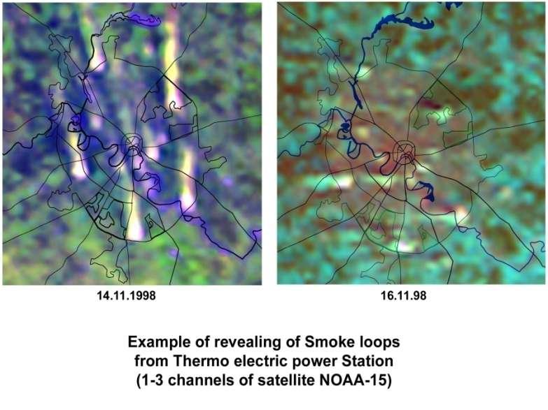
26 SATELLITE ENVIRONMENTAL MONITORING Let us consider the thermal Infra Red anomalies, relating to Power Plants

27
28 SMOKE LOOPS
29
30 SATELLITE MONITORING OF FOREST FIRES

31 Siberia region

32 Moscow region

33 Pacific Region

34 Pacific Region

35 SEA ICE MONITORING IN THE OKHOTSK SEA
36 SNOW SURFACE

37 Large city pollutions on the snow
38 FLOOD EVENTS

39 Detection and estimates of floods
40 Global Monitoring for Environment and Security (GMES) There is a need for a global infrastructure of data due to GIGAS activities such as GMES (Global Monitoring for Environment and Security), GEOSS (Global Earth Observing System of Systems) and INSPIRE. GMES is a joint ESA-EU initiative and GMES services will all be designed to meet common data and information requirements and will have global dimension.
41 GMES provide Europe with an independent global information system in support of its Environment and Security policies. GMES is developing into a major European activity. GMES aims to link major satellite and surface based systems for Global Environmental Observations of the atmosphere, oceans, land and biota.
42 Russian satellite datasets For many years Russia has been carrying out an extensive programme of Earth Observation using a range of satellite remote sensing instruments. Russian satellites have collected large volumes of data over the years, and exploitation of this data world-wide could have a wide variety of uses, notably Environmental Monitoring and Natural Disaster mitigation.
43 For Russian data to be considered as part of this, it needs to be accessible, linked to, and interoperable with, other National (EOSDIS) and International (INFEO) Information Systems. However, despite the large volumes of data generated by these systems they are not exploited as much as they could be, especially outside Russia. It is important that such potentially useful datasets are utilised to the maximum extent possible in order to achieve maximum cost effectiveness from the previous space investments and to justify future expenditure on new and continuing programmes.


44 EOSDIS EOSDIS (Earth Observing System Data and Information System)
45 EOSDIS One of the world's largest scientific data systems, EOSDIS has stored over three petabytes of earth science data in a geographically distributed mass storage system. Many changes have occurred in the ten years while the system was operational. In its first operational year (2000), the EOSDIS system had increased NASA's collection of earth science data holdings eight-fold. Today, EOSDIS collects over 7,000 gigabytes of data per week, almost 60 times more than the hubble space telescope.
46 EOSDIS The Earth Observing System (EOS) Data and Information System (EOSDIS) enables the collection of Earth science data from the EOS spacecraft. As NASA's Earth science data system, EOSDIS provides command and control, scheduling, data processing, and data archiving and distribution services for EOS missions. Earth Observing System (EOS) is a
47 EOS data coordinated series of polar-orbiting and low inclination satellites for long-term global observations of the land surface, biosphere, solid Earth, atmosphere, and oceans. EOS is a major component of the Earth Science Division of NASA's Science Mission Directorate. EOS enables an improved understanding of the Earth as an integrated system.

48
49 EOSDIS Main goals of EOSDIS are improvement of mechanisms for data access by arranging Data Centers DAAC for information exchange and creating metadata bases; creation of spatial databases; creation of theme data, crucial for government organization and holding of national discussion forums; preparation of educational programmes for personnel training; development of comprehensive partnership and coordination of data collection and usage.
50 The Distributed Active Archive Centers (DAAC's) process, archive, document, and distribute data from NASA's past and current Earth-observing satellites and field measurement programs. Each center serves a specific Earth system science discipline and provides users with data products, services, and data-handling tools unique to the center's specialty. User services include:(i) Assistance in selecting and obtaining data, (ii) Access to datahandling and visualization tools, (iii) Notification of data-related news, (iv) Technical support and referrals
 GMES (Global Monitoring for Environment and Security) GEOSS (Global Earth Observation System of")
51 Earth Observation Programme of the European Commission INFEO (Infrastructure for Spatial Information in Europe) eoportal Data access Portal ESA Group on Earth Observations (GEO) GMES (Global Monitoring for Environment and Security) GEOSS (Global Earth Observation System of Systems)
52 INFEO INFEO offers access to Earth Observation data, services and data catalogues around the world. Informational system INFEO (Infrastructure for Spatial Information in Europe) is an initiative of European Space Agency, which is entrusted to solve the problem of access to distributed Earth Observation data. Fundamental principle of this system is providing interoperability
53 INFEO Interoperability is the ability of interaction for heterogeneous services and data catalogues within the bounds of unified informational system. The main functions of INFEO system are creation of uniform information environment, providing single access point for information
54 INFEO search of data and retrieval in all archives and catalogues, registered in the system, independently of their geographical location and internal data format. Nodes network, so-called Middleware Nodes (MWNDs), underlies in firstgeneration distributed informational system. Every node contains collections metadata, which describe data, accessible through gateways.
55 CIP/ODBC Gateway Users can receive the access to eoportal data over MWNDs. MWND (middleware node) in a top-level component of INFEO/eoPortal.
56 INFEO For information retrieval, user inquires system via WWW-server on one of the MWND nodes, where distributed request is formed and then sent to relevant gateways. Request results are united and shown to user. Gateway is intermediate between MWND node and data provider s catalogue or archive. Gateway exchanges information with MWND node via CIP (Catalogue Interoperability Protocol), receiving search queries from it and returning search results in respond.
57 INFEO For the user the goal of CIP was one single interface to access to distributed international EO catalogues, locate diverse EO data sets, use data from different disciplines, access data in themes, use browse, inventory, directory, order. For the provider, the goal of CIP was one single toolkit to re-use software, access to all my catalogues, save costs, increase services, increase user community. CIP, regulating rules of interaction for users and EO data catalogues, underlies in distributed informational system.
58 INFEO Special three-level principle for access distribution is used to support simultaneous user access to great number of catalogues. User specifies inquiry via web-interface and sends it to MWND node, which correspondingly redirects the query to a set of data catalogues servers. Servers, which possess data, which meet search criteria, return responses to MWND node, via which user gets unified search result.
59 SSE The logical extension of INFEO system was development and adoption of secondgeneration technologies. The reason for it was aspiration to extend Earth Observation participation in global ecological monitoring, to improve interaction with worldwide information EO systems for the tasks of Natural Environment protection and necessity to support demands of INSPIRE EU Directions regarding compatibility with other informational systems.
60 Second-generation integration technologies development is aimed at migration from approach, based on Z39.50/Gateways technology, to usage of web-services (XML over SOAP/HTTP) for connecting external catalogues with INFEO catalogues. Secondgeneration integration technologies, which had been named EOLI-XML, is external interface for message exchange between server and client, based on SOAP protocol.
61 SSE EOLI-XML technology underlies in SSE (Service Support Environment) system, which is developed for solving stated problems by creating open, service-oriented, distributed environment. SSE system is infrastructure, unified environment for consumers and providers of data and services.
62 SSE unifies its users on basis of XML standard with usage of SOAP messages exchange protocols and description language of web-services WSDL (Web Service Definition Language). Any service that is being integrated into SSE environment should provide SOAP-interface, according to SSE ICD (Interface Control Document). Main objectives of SSE infrastructure creation are provide environment,
63 maximally simplifying interaction of serviceprovider user and service-provider service-provider types; simplify integration of already existing services, providing versatile XML-based interface, permitting evasion of changing structure; provide users with unified entry point Internet portal of the system. SSE system consists of two major constituents: SSE Portal Server and AOI Server, together forming Internet-portal, with which the end user interacts.
64 SSE The SSE platform is based on different technologies that have been integrated into a unique and powerful environment. To orchestrate the supply chain of EO and Geospatial Information, SSE provides the best available technologies and standards: SSE supports the Service Oriented Architecture (SOA) paradigm and simplifies the integration of Web services through the Toolbox environment.
65 SSE Toolbox environment accessible as a free download from the SSE portal which converts any legacy service in a SOA based one, dramatically reducing the coding problems. The service chaining is supported by an orchestration engine that provides a Standard workflow definition language. dramatically reducing the coding problems.
66 SSE The service chaining is supported by an orchestration engine that provides a Standard workflow definition language. The service provider can decide, without restraint, to capitalize on a workflow editor or to use its default workflows. The Service output can be published in different ways exploiting a wide set of geospatial information tools and services either on the provider or on the SSE side,
67 SSE including an interface to the ESA DDS (Interface Control Document) for data delivery via satellite. This approach allows the service provider to offer the functionalities either as individual Web services or aggregated at a single interface and: foster the development of reusable services avoid the duplication of frequently used processing software
68 SSE facilitate the combination of any services to business processes ( Orchestration ). The definition and prototyping of services is made easy within the Service Support Environment (SSE), a neutrally managed, open and distributed platform. SSE offers an exclusive opportunity to integrate a wide range of heterogeneous Earth Observation data and Geospatial information services, including product catalogues.
69 Experiment excellence joining the community of developers and value adders which exploits SSE, its unique test bed, and the best available technologies and standards. The SSE environment supports service prototyping and demonstration processes, allowing to design automatically executed workflows. This avoids the manual replication of the same task, with a valuable decrease of the overall development effort.
70 In this way SSE streamlines both the time to get the Earth Observation data and that to deliver the service to the end-user. SSE works to: SSE Orchestrate synchronous and asynchronous Web Services for online and offline processes Provide an overarching infrastructure, neutrally managed by ESA Integrate the access to Earth Observation data within service prototyping and delivery
71 SSE Empower service providers through a business process management platform Minimize service providers upfront investments Allow the use of Open standards to facilitate adoption and evolution Facilitate the integration of satellite data and geospatial information within the processing and exploitation chains
72 Technologies and principles of building distributed systems, have great potential for further development and even today they provide extensive means for arranging distributed heterogeneous data and services in single global system. Extension vector of each next generation of distributed informational systems consists of three main summands: going away from shortcomings of existing system, improving technical and informational characteristics, solving new problems, which did not even exist at a point of development previousgeneration system.
73 SSE Russian segment Russian scientists took active participation in projects of building distributed systems all generation both in development and adoption phases. Thus, on basis of INFEO IRIS and INSPIRE (EOLI-XML and SSE technologies) projects, Russian segment of distributed informational system on the basis SSE have been built. Russian segment of distributed informational system for satellite archives have been implemented with collaboration of Space Research Institute (IKI) and Institute of Automation and Control Process (IAPU), Vladyvostok.
74 SSE Russian segment Laboratory of Satellite Monitoring of Institute Automatic and Controls Process, Vladyvostok ( acts as the Remote Sensing data provider for Pacific and Far- East Regions. Software and hardware for functioning of the segment is located in Space Research Institute, Moscow ( Scientific community of Remote Sensing has gained opportunity to access data of one of Russian EO satellite data providers via global distributed system.
75 SSE Russian segment The main aim of this project is to improve the accessibility of Russian Satellite Remote Sensing data, generating Russian satellite information resources, linking the information resurces with Russia and with the European eo/porrtal (metadata/catalogue) system in order to provide interoperable catalogue access and ensuring that end users are involved, provide a single point of access to data.
76 Russian segment SSE Russian segment SSE provides: i) Environment to bring together data users and providers, ii) Homogeneous Access to international heterogeneous catalogues of geospatial metadata and documentation, iii) Search of multiple catalogues at the same time, iv) One Search Interface and garmonised presentation of results.
77 SEARCH TYPES: i) detailed descriptions about data sets, data sources, instruments, projects ii) single point of entry for facilititating the use of Satellite imagery and GIS. RESULT of SEARCH: online access to existing data.
78 CONCLUSION Remote Sensing EO data is one of important sources for geospatial data and information. Considerable progress has been made in: i) Remote Sensing data access, ii) Interoperability, iii) Management of very large volumes of EO data. Thank to data harmonization efforts, using ISO and OGC standards access to satellite datasets archived at through eo/portal Data Gateway. Russian segment of SSE provide an huge amount of Remote Sensing data to a broad user community in Russia.
EXPECTATIONS OF TURKISH ENVIRONMENTAL SECTOR FROM INSPIRE
 EXPECTATIONS OF TURKISH ENVIRONMENTAL SECTOR FROM INSPIRE June, 2010 Ahmet ÇİVİ Tuncay DEMİR INSPIRE in the Eyes of MoEF Handling of Geodata by MoEF Benefits Expected TEIEN First Steps for INSPIRE Final
Roadmap to interoperability of geoinformation
 Roadmap to interoperability of geoinformation and services in Europe Paul Smits, Alessandro Annoni European Commission Joint Research Centre Institute for Environment and Sustainability paul.smits@jrc.it
ESASky, ESA s new open-science portal for ESA space astronomy missions
 ESASky, ESA s new open-science portal for ESA space astronomy missions Bruno Merín ESAC Science Data Centre European Space Agency bruno.merin@esa.int Visit to NAOC, Beijing, 19/05/2017 ESA UNCLASSIFIED
INSPIREd solutions for Air Quality problems Alexander Kotsev
 INSPIREd solutions for Air Quality problems Alexander Kotsev www.jrc.ec.europa.eu Serving society Stimulating innovation Supporting legislation The European data puzzle The European data puzzle 24 official
Global Geospatial Information Management Country Report Finland. Submitted by Director General Jarmo Ratia, National Land Survey
 Global Geospatial Information Management Country Report Finland Submitted by Director General Jarmo Ratia, National Land Survey Global Geospatial Information Management Country Report Finland Background
Spatial Data Infrastructure Concepts and Components. Douglas Nebert U.S. Federal Geographic Data Committee Secretariat
 Spatial Data Infrastructure Concepts and Components Douglas Nebert U.S. Federal Geographic Data Committee Secretariat August 2009 What is a Spatial Data Infrastructure (SDI)? The SDI provides a basis for
Spatial Data Availability Energizes Florida s Citizens
 NASCIO 2016 Recognition Awards Nomination Spatial Data Availability Energizes Florida s Citizens State of Florida Agency for State Technology & Department of Environmental Protection Category: ICT Innovations
INSPIRE - A Legal framework for environmental and land administration data in Europe
 INSPIRE - A Legal framework for environmental and land administration data in Europe Dr. Markus Seifert Bavarian Administration for Surveying and Cadastre Head of the SDI Office Bavaria Delegate of Germany
EuroSDR (European Spatial Data Research)
") EuroSDR (European Spatial Data Research) ROLLING RESEARCH PLAN 2015-2018 EuroSDR Secretariat Public Governance Institute KU Leuven Parkstraat 45 bus 3609 3000 Leuven Belgium Tel.: +32 16 32 31 80 Fax:
EuroSDR (European Spatial Data Research) ROLLING RESEARCH PLAN 2015-2018 EuroSDR Secretariat Public Governance Institute KU Leuven Parkstraat 45 bus 3609 3000 Leuven Belgium Tel.: +32 16 32 31 80 Fax:
GIS at UCAR. The evolution of NCAR s GIS Initiative. Olga Wilhelmi ESIG-NCAR Unidata Workshop 24 June, 2003
 GIS at UCAR The evolution of NCAR s GIS Initiative Olga Wilhelmi ESIG-NCAR Unidata Workshop 24 June, 2003 Why GIS? z z z z More questions about various climatological, meteorological, hydrological and
GIS Building Communities beyond National Borders (Building Successful Spatial Data Infrastructures) Nick Land, ESRI Europe
 Nick Land, ESRI Europe") GIS Building Communities beyond National Borders (Building Successful Spatial Data Infrastructures) Nick Land, ESRI Europe UK worst flooding in the last 60 years 350,000 households without drinking water
GIS Building Communities beyond National Borders (Building Successful Spatial Data Infrastructures) Nick Land, ESRI Europe UK worst flooding in the last 60 years 350,000 households without drinking water
Oman NSDI Business Values and Future Directions. Hassan Alawi Alghazali Acting Director General National Spatial Data Infrastructure
 Oman NSDI Business Values and Future Directions Hassan Alawi Alghazali Acting Director General National Spatial Data Infrastructure Presentation Outline Geospatial Maturity Current Challenges NCSI s Role
INSPIRE General Introduction & Service Architecture
 INSPIRATION Spatial Data Infrastructure in the Western Balkans INSPIRE General Introduction & Service Architecture 1st National INSPIRATION Workshop Croatia November 21-22, 2012 A multi-countryprojectfunded
Ready for INSPIRE.... connecting worlds. European SDI Service Center
 Ready for INSPIRE Consultancy SOFTWARE T r a i n i n g Solutions... connecting worlds European SDI Service Center Increasing Added Value with INSPIRE and SDI Components INSPIRE In 2007, the European Commission
The Swedish National Geodata Strategy and the Geodata Project
 The Swedish National Geodata Strategy and the Geodata Project Ewa Rannestig, Head of NSDI Co-ordination Unit, Lantmäteriet, ewa.rannstig@lm.se Ulf Sandgren, Project Manager Geodata Project, Lantmäteriet,
INSPIRing Geospatial Framework For Local Administrations
 This project is financed by the European Union and the Republic of Turkey Presented at the FIG Congress 2018, May 6-11, 2018 in Istanbul, Turkey National Programme for Turkey 2010 Instrument for Pre-Accession
Discovery and Access of Geospatial Resources using the Geoportal Extension. Marten Hogeweg Geoportal Extension Product Manager
 Discovery and Access of Geospatial Resources using the Geoportal Extension Marten Hogeweg Geoportal Extension Product Manager DISCOVERY AND ACCESS USING THE GEOPORTAL EXTENSION Geospatial Data Is Very
Open Data meets Big Data
 Open Data meets Big Data Max Craglia, Sven Schade, Anders Friis European Commission Joint Research Centre www.jrc.ec.europa.eu Serving society Stimulating innovation Supporting legislation JRC is Technical
SPATIAL INFORMATION GRID AND ITS APPLICATION IN GEOLOGICAL SURVEY
 SPATIAL INFORMATION GRID AND ITS APPLICATION IN GEOLOGICAL SURVEY K. T. He a, b, Y. Tang a, W. X. Yu a a School of Electronic Science and Engineering, National University of Defense Technology, Changsha,
Proposal for a DIRECTIVE OF THE EUROPEAN PARLIAMENT AND OF THE COUNCIL. establishing an infrastructure for spatial information in the Community
 Proposal for a DIRECTIVE OF THE EUROPEAN PARLIAMENT AND OF THE COUNCIL establishing an infrastructure for spatial information in the Community INSPIRE http://inspire.jrc.it/ Alessandro Annoni 1 EU Commission
Norwegian spatial data infrastructure supporting disaster risk management Norwegian Mapping Authority
 Norwegian spatial data infrastructure supporting disaster risk management Norwegian Mapping Authority Arvid Lillethun, Norwegian Mapping Authority Land and Poverty 2018 Conference, World Bank 19.-23. March
SYNERGY OF SATELLITE REMOTE SENSING AND SENSOR NETWORKS ON GEO GRID
 SYNERGY OF SATELLITE REMOTE SENSING AND SENSOR NETWORKS ON GEO GRID National Institute of Advanced Industrial Science and Technology, Japan Yoshio Tanaka (on behalf of AIST GEO Grid team) Contents Brief
Spatially Enabled Society
 International Seminar on Land Administration Trends and Issues in Asia and the Pacific Region Spatially Enabled Society Abbas Rajabifard Vice Chair PCGIAP-WG3 Vice-President (President Elect), GSDI Association
The Process of Spatial Data Harmonization in Italy. Geom. Paola Ronzino
 The Process of Spatial Data Harmonization in Italy Geom. Paola Ronzino ISSUES Geospatial Information in Europe: lack of data harmonization the lack of data duplication of data CHALLENGES Challenge of INSPIRE:
GSCB Workshop 2009: EUMETSAT Missions
 GSCB Workshop 2009: EUMETSAT Missions Dr. Harald Rothfuss, EUMETSAT. GSCB Workshop 2007, ESRIN, Frascati, 18-19 June 2009. Slide: 1 Introduction To EUMETSAT The European Organisation for the Exploitation
SWEDISH SDI DEVELOPMENT & IMPLEMENTATION OF INSPIRE
 SWEDISH SDI DEVELOPMENT & IMPLEMENTATION OF INSPIRE Christina Wasström, Lantmäteriet, 801 82 Gävle, Sweden, christina.wasstrom@lm.se ABSTRACT The Swedish Government and Parliament has given Lantmäteriet
a national geological survey perspective François ROBIDA BRGM (French Geological Survey)
") a national geological survey perspective François ROBIDA BRGM (French Geological Survey) Pre-Conference Seminar on Socio-Economic Value of Geospatial for National and Regional Development 21 August 2017,
a national geological survey perspective François ROBIDA BRGM (French Geological Survey) Pre-Conference Seminar on Socio-Economic Value of Geospatial for National and Regional Development 21 August 2017,
Portals: Standards in Action
 Portals: Standards in Action David Danko ISO TC 211 Metadata Project Leader GIS Standards Consultant-ESRI. Metadata Portals Portal gateway, place of entry Producers Advertise, expose products Share information
INSPIRE Basics. Vlado Cetl European Commission Joint Research Centre. https://ec.europa.eu/jrc/
 INSPIRE Basics Vlado Cetl European Commission Joint Research Centre https://ec.europa.eu/jrc/ Serving society Stimulating innovation Supporting legislation Outline SDI? Why European SDI? INSPIRE Policy
Earth Observation and GEOSS in Horizon Copernicus for Raw Material Workshop 5 th September 2016
 Earth Observation and GEOSS in Horizon 2020 Copernicus for Raw Material Workshop 5 th September 2016 Gilles OLLIER Head of Sector -Earth observation Directorate Environment Unit I.4 Climate Actions and
Geological information for Europe : Towards a pan-european Geological Data Infrastructure
 Geological information for Europe : Towards a pan-european Geological Data Infrastructure Integrating geoscientific information for EU competitiveness Co-funded by the European Union European societal
The future of SDIs. Ian Masser
 The future of SDIs Ian Masser Presentation Considers two questions relating to the future development of SDIs throughout the world Where have we got to now? Where should we go from here? Identifies four
Open spatial data infrastructure
 Open spatial data infrastructure a backbone for digital government Thorben Hansen Geomatikkdagene 2018 Stavanger 13.-15. mars Spatial Data Infrastructure definition the technology, policies, standards,
Enabling ENVI. ArcGIS for Server
 Enabling ENVI throughh ArcGIS for Server 1 Imagery: A Unique and Valuable Source of Data Imagery is not just a base map, but a layer of rich information that can address problems faced by GIS users. >
ESTABLISHMENT OF KARNATAKA GEOPORTAL AND ITS ROLE IN PLANNING
 ESTABLISHMENT OF KARNATAKA GEOPORTAL AND ITS ROLE IN PLANNING By H. Hemanth Kumar Karnataka State Council for Science & Technology (KSCST), Indian Institute of Science, Bangalore, India Abstract Natural
ArcGIS for INSPIRE. Marten Hogeweg Satish Sankaran
 ArcGIS for INSPIRE Marten Hogeweg Satish Sankaran Outline What is ArcGIS ArcGIS for INSPIRE Web GIS Case Studies Roadmap Q&A What is INSPIRE? INSPIRE is the legal framework for a European Spatial Data
The Canadian Ceoscience Knowledge Network. - A Collaborative Effort for Unified Access to Ceoscience Data
 The Canadian Ceoscience Knowledge Network - A Collaborative Effort for Unified Access to Ceoscience Data The Canadian Geoscience Knowledge Network A Collaborative Effort for Unified Access to Geoscience
NOKIS - Information Infrastructure for the North and Baltic Sea
 NOKIS - Information Infrastructure for the North and Baltic Sea Carsten Heidmann 1 and Jörn Kohlus 2 Abstract 1. General The initial motivation for the project NOKIS (German title: Nord- und Ostsee-Küsteninformationssystem)
Charter for the. Information Transfer and Services Architecture Focus Group
 for the Information Transfer and Services Architecture Focus Group 1. PURPOSE 1.1. The purpose of this charter is to establish the Information Transfer and Services Architecture Focus Group (ITSAFG) as
SDI-Challenges European perspective
 THE HIGH LEVEL FORUM ON GLOBAL GEOSPATIAL INFORMATION MANAGEMENT Seoul, Republic of Korea, 24-26 October 2011 Session 1: Challenges in geospatial policy formation and institutional arrangements SDI-Challenges
RESEARCG ON THE MDA-BASED GIS INTEROPERABILITY Qi,LI *, Lingling,GUO *, Yuqi,BAI **
 RESEARCG ON THE MDA-BASED GIS INTEROPERABILITY Qi,LI *, Lingling,GUO *, Yuqi,BAI ** * Digital Earth Studio, Peking University, Beijing, 100871 liqi@pku.edu.cn, guolingling@cybergis.org.cn ** Network Department,
Key Points Sharing fosters participation and collaboration Metadata has a big role in sharing Sharing is not always easy
 Sharing Resources Geoff Mortson esri, Inc. SDI Solutions Team Key Points Sharing fosters participation and collaboration Metadata has a big role in sharing Sharing is not always easy Data Sharing is Good
EuroGEOSS Protected Areas Pilot
 EuroGEOSS Protected Areas Pilot Max Craglia European Commission Joint Research Centre Part 1: the present MyNatura2000 Mobile app. Awareness raising & volunteered data collection. Natura2000 covers 18%
Observation (EO) & Geomatics in Canada
 & Geomatics in Canada") Innovating to Increase the Impact of Earth Observation (EO) & Geomatics in Canada Natural Resources Canada February 25, 2014 Prashant Shukle, Director General Canada Centre for Mapping and Earth Observation
Innovating to Increase the Impact of Earth Observation (EO) & Geomatics in Canada Natural Resources Canada February 25, 2014 Prashant Shukle, Director General Canada Centre for Mapping and Earth Observation
Harmonizing spatial databases and services at local and regional level
 Harmonizing spatial databases and services at local and regional level A. Ionita 1, M. Caian 2, V. Vassilev 3, V. Craciunescu 2, I. Nedelcu 4 1 Research Institute for Artificial Intelligence, Bucuresti,
Building a national spatial data infrastructure. Thorben Hansen, Head of Division Danish Agency for Data Supply and Efficiency
 Building a national spatial data infrastructure Thorben Hansen, Head of Division Danish Agency for Data Supply and Efficiency About Spatial Data Infrastructure Spatial data come from many sources and is
Pushing the Standards Edge: Collaborative Testbeds to Accelerate Standards Development and Implementation
 Pushing the Standards Edge: Collaborative Testbeds to Accelerate Standards Development and Implementation Mark E. Reichardt President mreichardt@opengeospatial.org 31 October 2006 2006 Open Geospatial
Technical Specifications. Form of the standard
 Used by popular acceptance Voluntary Implementation Mandatory Legally enforced Technical Specifications Conventions Guidelines Form of the standard Restrictive Information System Structures Contents Values
Study on Data Integration and Sharing Standard and Specification System for Earth System Science
 Study on Data Integration and Sharing Standard and Specification System for Earth System Science Juanle Wang and Jiulin Sun Information Sharing Center for Earth System Science Institute of Geographic Sciences
Infrastructure for Spatial Information in Europe (INSPIRE)
") Infrastructure for Spatial Information in Europe (INSPIRE) 2011 GISCO Working Party 8-9.3.2012 INSPIRE is about improving access to spatial information: the environment doesn t stop at borders EU Geoportal
Infrastructure for Spatial Information in Europe (INSPIRE) 2011 GISCO Working Party 8-9.3.2012 INSPIRE is about improving access to spatial information: the environment doesn t stop at borders EU Geoportal
Data Origin. Ron van Lammeren CGI-GIRS 0910
 Data Origin Ron van Lammeren CGI-GIRS 0910 How to obtain geodata? Geo data initiative Executive Order 12906, "Coordinating Geographic Data Acquisition and Access: The National Spatial Data Infrastructure,"
US National Spatial Data Infrastructure A Spatial Framework for Governance and Policy Development to Enable a Location-Based Digital Ecosystem
 GeoPlatform Workshop 7 Dec 2016, Department of the Interior Washington, D.C. US National Spatial Infrastructure A Spatial Framework for Governance and Policy Development to Enable a Location-Based Digital
Data Origin. How to obtain geodata? Ron van Lammeren CGI-GIRS 0910
 Data Origin How to obtain geodata? Ron van Lammeren CGI-GIRS 0910 Spatial Data interest Improvement of policy making. ± 90% of all information used by government has spatial characteristics SPATIAL INFORMATION
Interoperable Services for Web-Based Spatial Decision Support
 Interoperable Services for Web-Based Spatial Decision Support Nicole Ostländer Institute for Geoinformatics, University of Münster Münster, Germany ostland@uni-muenster.de SUMMARY A growing number of spatial
PaikkaOppi - a Virtual Learning Environment on Geographic Information for Upper Secondary School
 PaikkaOppi - a Virtual Learning Environment on Geographic Information for Upper Secondary School Jaakko Kähkönen*, Lassi Lehto*, Juha Riihelä** * Finnish Geodetic Institute, PO Box 15, FI-02431 Masala,
ArcGIS for INSPIRE. Marten Hogeweg
 ArcGIS for INSPIRE Marten Hogeweg Please Take Our Survey on the App Download the Esri Events app and find your event Select the session you attended Scroll down to find the feedback section Complete answers
Building a National Data Repository
 Building a National Data Repository Mladen Stojic, Vice President - Geospatial 1/30/2013 2012 Intergraph Corporation 1 Information has meaning and gives power only when shared and distributed. Information,
CHAPTER 22 GEOGRAPHIC INFORMATION SYSTEMS
 CHAPTER 22 GEOGRAPHIC INFORMATION SYSTEMS PURPOSE: This chapter establishes the administration and use of to improve the quality and accessibility of Department s spatial information and support graphical
The EOC Geoservice: Standardized Access to Earth Observation Data Sets and Value Added Products
 The EOC Geoservice: Standardized Access to Earth Observation Data Sets and Value Added Products Klaus Dengler, Torsten Heinen, Albert Huber, Katrin Molch, Eberhard Mikusch DLR German Remote Sensing Data
A Model of GIS Interoperability Based on JavaRMI
 A Model of GIS Interoperability Based on Java Gao Gang-yi 1 Chen Hai-bo 2 1 Zhejiang University of Finance & Economics, Hangzhou 310018, China 2 College of Computer Science and Technology, Zhejiang UniversityHangzhou
GIS for the Beginner on a Budget
 GIS for the Beginner on a Budget Andre C. Bally, RLA, GIS Coordinator, Harris County Public Infrastructure Department Engineering Division This presentation, GIS for Beginners on a Budget. will briefly
Innovation in Land Management: Integrated Solutions For National Cadastre Projects
 Success With GIS Innovation in Land Management: Integrated Solutions For National Cadastre Projects XXIII International FIG Congress Munich These documents are only complete, when used in connection with
Using OGC standards to improve the common
 Using OGC standards to improve the common operational picture Abstract A "Common Operational Picture", or a, is a single identical display of relevant operational information shared by many users. The
INSPIRE in Sweden - an Important Part of the National Geodata Strategy
 INSPIRE in Sweden - an Important Part of the National Geodata Strategy Ewa RANNESTIG and Monica LAGERQVIST NILSSON, Sweden Key words: National Geodata Strategy, National Infrastructure for Spatial Information,
Compact guides GISCO. Geographic information system of the Commission
 Compact guides GISCO Geographic information system of the Commission What is GISCO? GISCO, the Geographic Information System of the COmmission, is a permanent service of Eurostat that fulfils the requirements
Spatially enabling e-government through geo-services
 Spatially enabling e-government through geo-services Mauro Salvemini EUROGI PRESIDENT Professor at Sapienza Università di Roma (IT) 1 About the presentation Few information about Eurogi ; Some essential
Spatial data interoperability and INSPIRE compliance the platform approach BAGIS
 Spatial data interoperability and INSPIRE compliance the platform approach BAGIS BAGIS Voluntary, independent, public, non-profit organization; Organization with main mission to promote the growth of the
Major Opportunities in Spatial Data Infrastructure Communities
 Major Opportunities in Spatial Data Infrastructure Communities Bas Kok President GSDI June 17 th 2008 FIG Working Week: Integrating Generations 14-19 June 2008 Stockholm, Sweden http://www.gsdi.org 1 GSDI
reviewed paper EU-Project: Cross-border Spatial Information System with High Added Value (CROSS-SIS) Stefan SANDMANN
 Stefan SANDMANN") reviewed paper EU-Project: Cross-border Spatial Information System with High Added Value (CROSS-SIS) Stefan SANDMANN Surveying and Mapping Agency NRW, Bonn, Muffendorfer Str. 19-21, Germany, sandman@lverma.nrw.de
reviewed paper EU-Project: Cross-border Spatial Information System with High Added Value (CROSS-SIS) Stefan SANDMANN Surveying and Mapping Agency NRW, Bonn, Muffendorfer Str. 19-21, Germany, sandman@lverma.nrw.de
ArcGIS. for Server. Understanding our World
 ArcGIS for Server Understanding our World ArcGIS for Server Create, Distribute, and Manage GIS Services You can use ArcGIS for Server to create services from your mapping and geographic information system
GSDI Global Spatial Data Infrastructure. Convergences between Geo Spatial Communities: key decision for decision making
 GSDI Global Spatial Data Infrastructure Convergences between Geo Spatial Communities: key decision for decision making April 14 th 2010 Bas Kok GSDI Past-President Director of International Affairs, Dutch
Adding value to Copernicus services with member states reference data
 www.eurogeographics.org Adding value to Copernicus services with member states reference data Neil Sutherland neil.sutherland@os.uk GIS in the EU 10 November 2016 Copyright 2016 EuroGeographics 61 member
FINDINGS OF THE ARCTIC METEOROLOGY SUMMIT
 FINDINGS OF THE ARCTIC METEOROLOGY SUMMIT 2018 WWW.FMI.FI CHAIR S SUMMARY: 1 2 3 We need to be curious to explore the known unknowns. Meteorology is an elemental part of international collaboration in
RUSSIAN EARTH OBSERVATION MISSIONS: satellites, ground segment and data access evolution
 RUSSIAN EARTH OBSERVATION MISSIONS: satellites, ground segment and data access evolution Tamara Ganina Deputy Chief of Prospective Development Dep. WGISS-40 UKSA, Harwell, UK September 28 October 2, 2015
The PREVIEW Global Risk Data Platform: a geoportal to serve and share global data on risk to natural hazards
 The PREVIEW Global Risk Data Platform: a geoportal to serve and share global data on risk to natural hazards Gregory Giuliani (UNEP/GRID-Geneva & University of Geneva/enviroSPACE ) http://www.grid.unep.ch
GEOSPATIAL WEB SERVICE INTEGRATION AND MASHUPS FOR WATER RESOURCE APPLICATIONS
 GEOSPATIAL WEB SERVICE INTEGRATION AND MASHUPS FOR WATER RESOURCE APPLICATIONS C. Granell a, *, L. Díaz a, M. Gould a a Center for Interactive Visualization, Department of Information Systems, Universitat
Building a 4-D Weather Data Cube for the NextGen Initial Operating Capability (IOC)
") Building a 4-D Weather Data Cube for the NextGen Initial Operating Capability (IOC) Friends/Partners in Aviation Weather Vision Forum July 15, 2008 Bruce Lambert - DoD Tom Ryan FAA Jason Tuell NWS 1 Overview
Building a 4-D Weather Data Cube for the NextGen Initial Operating Capability (IOC) Friends/Partners in Aviation Weather Vision Forum July 15, 2008 Bruce Lambert - DoD Tom Ryan FAA Jason Tuell NWS 1 Overview
C o p e r n i c u s a n d W I G O S
 C o p e r n i c u s a n d W I G O S Jean-Noël Thépaut & Mark Dowell 24 October 2017 GEO XIV, Washington DC, 23-28 October 2017 T h e C o p e r n i c u s P r o g r a m m e Copernicus is the European Union
Paper UC1351. Conference: User Conference Date: 08/10/2006 Time: 8:30am-9:45am Room: Room 23-B (SDCC)
") Conference: User Conference Date: 08/10/2006 Time: 8:30am-9:45am Room: Room 23-B (SDCC) Title of Paper: Increasing the Use of GIS in the Federal Government Author Name: Miss Abstract This presentation
Conference: User Conference Date: 08/10/2006 Time: 8:30am-9:45am Room: Room 23-B (SDCC) Title of Paper: Increasing the Use of GIS in the Federal Government Author Name: Miss Abstract This presentation
U s i n g t h e E S A / E U M E T C A S T N a v i g a t o r s
 U s i n g t h e E S A / E U M E T C A S T N a v i g a t o r s Copernicus User Uptake Information Sessions Copernicus EU Copernicus EU Copernicus EU www.copernicus.eu I N T R O D U C T I O N O F U S E C
Water Data Sharing an Update
 Water Data Sharing an Update By David R. Maidment Leader, CUAHSI Hydrologic Information System Project and Director, Center for Research in Water Resources, University of Texas at Austin Prepared for Subcommittee
Kentucky Collaborates in GeoMAPP Project: The Advantages and Challenges of Archiving in a State with a Centralized GIS
 Kentucky Collaborates in GeoMAPP Project: The Advantages and Challenges of Archiving in a State with a Centralized GIS Geospatial Multistate Archive and Preservation Partnership By Glen McAninch Best Practices
THE DESIGN AND IMPLEMENTATION OF A WEB SERVICES-BASED APPLICATION FRAMEWORK FOR SEA SURFACE TEMPERATURE INFORMATION
 THE DESIGN AND IMPLEMENTATION OF A WEB SERVICES-BASED APPLICATION FRAMEWORK FOR SEA SURFACE TEMPERATURE INFORMATION HE Ya-wen a,b,c, SU Fen-zhen a, DU Yun-yan a, Xiao Ru-lin a,c, Sun Xiaodan d a. Institute
Land Use in the context of sustainable, smart and inclusive growth
 Land Use in the context of sustainable, smart and inclusive growth François Salgé Ministry of sustainable development France facilitator EUROGI vice president AFIGéO board member 1 Introduction e-content+
Demonstration of a local SDI solution with several stakeholders in pilot areas in line with EU best practices
 EU Twinning project for the Agency of Land Relations and Cadaster (ALRC)- Organization, Streamlining and Computerization Process in Mapping in the Republic of Moldova. Demonstration of a local SDI solution
Modern Education at Universities: Improvements through the Integration of a Spatial Data Infrastructure SDI into an e-learning Environment
 Modern Education at Universities: Improvements through the Integration of a Spatial Data Infrastructure SDI into an e-learning Environment Ingo Simonis Institute for Geoinformatics, University of Muenster
REGIONAL SDI DEVELOPMENT
 REGIONAL SDI DEVELOPMENT Abbas Rajabifard 1 and Ian P. Williamson 2 1 Deputy Director and Senior Research Fellow Email: abbas.r@unimelb.edu.au 2 Director, Professor of Surveying and Land Information, Email:
EuroGeographics & INSPIRE. Nick Land, Executive Director of EuroGeographics
 EuroGeographics & INSPIRE Nick Land, Executive Director of EuroGeographics EuroGeographics A growing association 49 Members, 42 countries Topographic mapping, cadastre, land registry + Networked organisation
Regional EGM on Community of Practice of Georeferenced Information System. for Disaster Risk Management (Geo-DRM) April 2014, Bangkok, Thailand
 April 2014, Bangkok, Thailand") Regional EGM on Community of Practice of Georeferenced Information System for Disaster Risk Management (Geo-DRM) 23-25 April 2014, Bangkok, Thailand Presented By Mukesh Kumar Keshari Ministry of Home Affairs
Regional EGM on Community of Practice of Georeferenced Information System for Disaster Risk Management (Geo-DRM) 23-25 April 2014, Bangkok, Thailand Presented By Mukesh Kumar Keshari Ministry of Home Affairs
Nomination Form. Clearinghouse. New York State Office for Technology. Address: State Capitol-ESP, PO Box
 NASIRE 2001 RECOGNITION AWARDS Recognizing Outstanding Achievement in the Field of Innovative Use of Technology Nomination Form Title of Nomination: Manager/Job Title: Agency: NYS Geographic Information
Challenges and Successes in Sharing Geospatial Data in Africa
 Challenges and Successes in Sharing Geospatial Data in Africa 2018 GeoNode Summit Torino, Italy March 26-28, 2018 Bernard Justus Muhwezi Manager, Geo-Information Services Uganda Bureau of Statistics, Kampala,
GIS FOR MAZOWSZE REGION - GENERAL OUTLINE
 GIS FOR MAZOWSZE REGION - GENERAL OUTLINE S. Bialousz 1), K Mączewski 2), E. Janczar 2), K. Osinska-Skotak 1) 1) Warsaw University of Technology, Warsaw, Poland 2) Office of the Surveyor of the Mazowieckie
Data Aggregation with InfraWorks and ArcGIS for Visualization, Analysis, and Planning
 Data Aggregation with InfraWorks and ArcGIS for Visualization, Analysis, and Planning Stephen Brockwell President, Brockwell IT Consulting, Inc. Join the conversation #AU2017 KEYWORD Class Summary Silos
Implementation of Inspire in Denmark - How we get it flying! Olav Eggers National Survey & Cadastre -Denmark
 Implementation of Inspire in Denmark - How we get it flying! Olav Eggers oe@kms.dk National Survey & Cadastre -Denmark Introduction Overview Infrastructure for Spatial Information Act National Survey and
Evaluating Sustainability of the Georesources Observation System
 Evaluating Sustainability of the Georesources Observation System Michael Mente Federal Institute for Geosciences and Natural Resources Germany, Hannover GEOSS-CBC Meeting Athens April 27th 28th, 2009 GEOSS-CBC
E-Government and SDI in Bavaria, Germany
 135 E-Government and SDI in Bavaria, Germany Wolfgang STOESSEL, Germany Key words: GDI-BY, Bavaria, Spatial Data Infrastructure SUMMARY Spatial Data Infrastructure (SDI) is an important part of the e-government
Turkey s National SDI Implementation
 Onur PAŞAOĞULLARI Head of Department Turkey s National SDI Implementation Presentation Plan NSDI Background General Directorate of Geographic Information Systems NSDI Project INSPIRE Directive Urban Information
Realizing benefits of Spatial Data Infrastructure A user s perspective from Environment Agency - Abu Dhabi
 Realizing benefits of Spatial Data Infrastructure A user s perspective from Environment Agency - Abu Dhabi Anil Kumar Director, Environment Information Management 26 April 2012 Geospatial World Forum,
Regional Spatial Data Infrastructures What Makes them Possible?
 Article for Geoinformatics June 2007 Regional Spatial Data Infrastructures What Makes them Possible? by Sam Bacharach Executive Director Outreach Open Geospatial Consortium, Inc. (OGC) INTRODUCTION The
The Saudi Experience
 The Saudi Experience The need for NSDI A national GIS Concept Study 1992 NSDI Basic Components Formation of the National Committee Obstacles Conclusion Sharing and utilizing the Geospatial data Cost effective