Garratt Lane, Wandsworth, London Borough of Wandsworth
|
|
|
- Alberta Nelson
- 6 years ago
- Views:
Transcription
1 Garratt Lane, Wandsworth, London Borough of Wandsworth An Archaeological Desk-Based Assessment for St James Homes by Jennifer Lowe Thames Valley Archaeological Services Ltd Site Code GLW 03/59 November 2003
2 Summary Site name: Garratt Lane, Wandsworth, London Borough of Wandsworth Grid reference: TQ Site activity: Desk-based assessment Project manager: Steve Ford Site supervisor: Jennifer Lowe Site code: GLW 03/59 Area of site: 0.12 ha Summary of results: The site is of archaeological potential and lies within an archaeological priority area within the Borough This report may be copied for bona fide research or planning purposes without the explicit permission of the copyright holder Report edited/checked by: Steve Ford Steve Preston i
3 Introduction Garratt Lane, Wandsworth, London Borough of Wandsworth An Archaeological Desk-Based Assessment by Jennifer Lowe Report 03/59 This desk-based study is an assessment of the archaeological potential of a roughly rectangular parcel of land located at Garratt Lane, Wandsworth (Fig. 1) and comprises the first stage of a process to determine the presence/absence, extent, character, quality and date of any archaeological remains which may be affected by redevelopment of the area. The project was commissioned by Mr Tim Webb of St James Homes, Wellington House, High Street, Hampton Hill, Middlesex, TW12 1NP. Site description, location and geology The site currently consists of 0.12 ha plot, containing 2 modern brick built structures, which occupy the corners of Garratt Lane and Furmage Street and Esparto Street and Furmage Street. The building are divided by an alleyway which provides access to the rear of the properties. No basements were apparent. The River Wandle lies to the west of the site. The development area is centred on TQ The site is located on river terraces (BGS 1981), and lies at a height of approximately 10m above Ordnance Datum. Planning background and development proposals Planning permission is being sought for the development of an apartment block, which will front on to Esparto Street. The eastern side of the building, which fronts Garratt Lane will be used for commercial purposes, as well as housing. The proposal also includes provision for underground car parking (Fig. 11). Archaeology and Planning (PPG ) provides guidance relating to archaeology within the planning process. It points out that where a desk-based assessment has shown that there is a strong possibility of significant archaeological deposits in a development area it is reasonable to provide more detailed information from a field evaluation so that an appropriate strategy to mitigate the effects of development on archaeology can be devised: Paragraph 21 states: Where early discussions with local planning authorities or the developer s own research indicate that important archaeological remains may exist, it is reasonable for the planning authority to 1
4 request the prospective developer to arrange for an archaeological field evaluation to be carried out... Should the presence of archaeological deposits be confirmed further guidance is provided. Archaeology and Planning stresses preservation in situ of archaeological deposits as a first consideration as in paragraphs 8 and 18. Paragraph 8 states:...where nationally important archaeological remains, whether scheduled or not, and their settings, are affected by proposed development there should be a presumption in favour of their physical preservation... Paragraph 18 states: The desirability of preserving an ancient monument and its setting is a material consideration in determining planning applications whether that monument is scheduled or unscheduled... However, for archaeological deposits that are not of such significance it is appropriate for them to be preserved by record (i.e., fully excavated and recorded by a competent archaeological contractor) prior to their destruction or damage. Paragraph 25 states: Where planning authorities decide that the physical preservation in situ of archaeological remains is not justified in the circumstances of the development and that development resulting in the destruction of the archaeological remains should proceed, it would be entirely reasonable for the planning authority to satisfy itself... that the developer has made appropriate and satisfactory provision for the excavation and recording of remains. The Wandsorth Unitary Development Plan, 1994, reiterates this point. Policy TBE31 states: Where development is proposed on sites identified as having archaeological significance, the Council will require developers to make provision for archaeological investigations. In appropriate cases, preservation in situ or excavation and recording may also be required. By virtue of its location on the banks of the River Wandle, the site lies within an area of archaeological importance within the Borough Unitary Development Plan. Methodology The assessment of the site was carried out by the examination of pre-existing information from a number of sources recommended by the Institute of Field Archaeologists paper Standards in British Archaeology covering desk-based studies. These sources include historic and modern maps, the Greater London Sites and Monuments Record, geological maps and any relevant publications or reports. 2
5 Archaeological and documentary background General background The site lies on a river gravel terrace, which has yielded a high density of finds of various date. In particular prehistoric activity is well attested on the river gravels of the Thames Valley and the survey of the SMR indicates that Wandsworth is no exception to this. A plot of the major Upper Palaeolithic and Mesolithic sites and find spots has highlighted their concentration along tributaries of the Thames, with the river Wandle being a good example of this (MoLAS 2000, 55; Map 2). In the subsequent periods the Wandle played an equally important role; it has been suggested that the Wandle was probably navigable in Roman times and would therefore have been a major route in this period (MoLAS 2000, 125). Saxon occupation followed the same pattern with settlements and cemeteries being concentrated around the various Thames tributaries, again in particular the Wandle (MoLAS 2000, 178). It is also during this period that the settlement of Wandsworth appears to have developed and continued to expand into the medieval period. Wandsworth is a Saxon place name meaning the enclosure of a man called Waendel (Mills 1998). The settlement has undergone various name changes from Wendleswurthe in the 7th century, Wendlesurd, Wandlesorde and Wandered in the 11th century, and finally Wandsworth in the 14th century. In AD 693 the area was part of a larger estate, which was granted to the nuns at Barking and then to Westminster Abbey in AD 1067, after which several estates were formed (VCH 1967, Gerhold 1998). Westminster Abbey had also established a church in Wandsworth, as well as at many other manors, by 1157 (Blair 1991). The area surrounding the site appears initially to have been part of the Dunsford manor, then later The Garratt which was established around the 16th century (VCH 1967). Wandsworth is mentioned in Domesday Book as being held by the Abbot of Saint-Wandille through Ingulf the monk. It was assessed at 1 hide under King Edward; but at nothing under William. There were 3 villans and 2 bordars with 1 plough, and the manor was worth 20 shillings (Williams and Martin, 2002, 79). Another manor in the area is recorded as being held by William fitzansculf. There were 2 halls and it was assessed at 12 hides, with land for 4 ploughs, and 22 acres of meadow. The whole manor was worth 110 shillings before the Conquest, but was worth 8 by the time of Domesday (Williams and Martin, 2002, 84). There is no obvious reason for this considerable increase in the value of the manor, which is not seen elsewhere. The later expansion of Wandsworth is mostly due to its location on the main road from London to the south-west, which gained further importance when a stone bridge was constructed across the Wandle in
6 The location of the settlement on the Wandle encouraged the development of the area by promoting industries such as fisheries and mills. The fisheries were well established by the 15th and 16th centuries and by the late 18th century it is recorded that 500 people within Wansdsworth were employed in factories and mills (VCH 1967). Greater London Sites and Monuments Record A search was made of the Greater London Sites and Monuments Record for a 500m radius around the site in July This revealed 24 entries, none of which were located on the site. The results of this search are summarized in Appendix 1, and the locations of the entries are plotted on Figure 1. Prehistoric Several flint implements have been retrieved from various locations around the site. A Palaeolithic chipping floor was recorded in and 1902 to the north east of the site, at St Anne s Hill. This included axes, scrapers, flakes and borers of Acheulian and Mousterian type [1]. Similarly flint implements of Palaeolithic date have also been recorded at Earlsfield also to the north east of the site [2]. In this case flint flakes, handaxes and a scraper were all recovered as well as a Neolithic axe. A hand axe, also Palaeolithic in date, was recovered from All Farthing Lane, which joins Garratt Lane further to the north [3]. St Anne s Hill also yielded flint flakes/blades dating to the Mesolithic [4; 5] Roman Only two entries in the SMR relate to this period. A 2nd-century cremation urn was located on the site of All Farthing School, on St Anne s Lane [6]. Also some Roman material is recorded as coming from the River Wandle, although it is not specified what this material is [7]. Medieval Only one entry relates to this period and this is for Garratt Lane itself [8]. The route appears to have originated in the medieval period as the main thoroughfare heading south from Wandsworth. The name Garratt is derived from an estate known to have existed in Post Medieval A post-medieval gravel quarry is recorded to the south-west of the site [9], and immediately to the south is a Grade II listed building formerly a Workhouse [10]. A 20th-century park is noted to the north-west of the site [11]. A quarry was identified during fieldwork on Garratt Lane, south of the site, and during the same investigation post-medieval cultivation soil was also recorded [12]. Similarly during fieldwork also on Garratt 4
7 Lane, this time to the north of the site, a ploughsoil was encountered dating to the 16th century, which overlay natural alluvium [13], and finally a Grade II Listed Building is noted on St Anne s Crescent [14]. Undated A watching brief on Garratt Lane [15] recorded no features of archaeological interest, and an evaluation [16] on Swaffield Road, which lies immediately to the south-east, recorded no evidence of human activity prior to the 19th century when part of the site was levelled, in addition some 19th/20th century garden features were encountered. Scheduled Ancient Monuments There are no Scheduled Ancient Monuments within the study area. Listed buildings There are no Listed Buildings on the site. Registered Parks and Gardens; Registered Battlefields There are no registered parks and gardens, or registered battlefield within the vicinity of the site. Aerial Photography The site has been developed within an urban setting since before the invention of aerial photography and there is no value in examining the relevant collections. Cartographic sources A range of Ordnance Survey and other historical maps of the area were consulted at the Public Records Office and the Metropolitan Archive, in order to ascertain what activity had been taking place throughout the site s later history and whether this may have affected any possible archaeological deposits within the proposal area (see Appendix 2). The earliest map available of the area is Saxton s map of Surrey, 1575 (Fig. 2). Wandsworth is noted on this map but there is very little detail for the settlement. The River Wandle is shown flowing north into the Thames, however, there is no development marked on this map along the route of the river. Similarly, Norden s 5
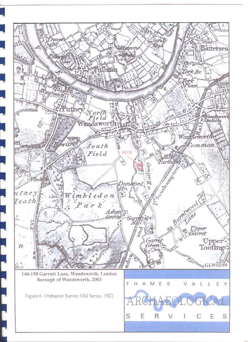
8 map of Surrey 1594, Van Den Keere s map of Surrey, 1603, and Speed s map of Surrey, 1611 show no further detail for the study area (not illustrated). According to Seller s map of Surrey, 1690 (Fig. 3) Wandsworth appears to have developed significantly with buildings lining the road from London to Kingston. The River Wandle is still clearly marked, one small building is noted along its length, just south of Wandsworth, however, it is not clear if this lies within the boundaries of the site. Senex s map of Surrey 1729 (Fig. 4) shows the area in more detail. Wandsworth has developed considerably, with several mills marked in the town and along the route of the Wandle. An area called Half Farthing is noted on this map which is most likely located in the area of All Farthing Lane which lies close to the proposal area. Garratt Green is also marked on this plan. According to Rocque s map of Surrey 1768 (Fig. 5) Garratt Lane now exists with the Wandle located to the west of it. The land between the river and Garratt Lane has remained, apart from an area of what appears to be formal gardens with buildings fronting onto the Wandle. Lindley and Crosley s map 1793 (not illustrated), shows no further significant development. By 1822, according to the Ordnance Survey Old Series (Fig. 6), the route of an iron railway is marked on this map along the length of Garratt Lane, depicted as a track rather than an actual railway. It represents the course of the Surrey Iron Railway which was built in 1801 by Act of Parliament and was the first public railway. It linked Wandsworth Dock with Croydon and continued in use until 1848 (Bayliss 1985). The site at this time is located on what appears to be a formal garden, which also has associated buildings. The First Edition Ordnance Survey from the 1870s (Fig. 7) shows the site in more detail. The Royal Paper Mill is located to the north of the site and is, at this time, well established. Immediately south of the site is Upper Wandle House, and to the north is Wandle House. The site appears to lie within the area of the formal gardens associated with Wandle House. According to the Second Edition Ordnance Survey map 1894/6 (Fig. 8) Wandle House appears to have lost its formal gardens, and the area south of the house is just open, undeveloped land. However by the 1916 Edition of Ordnance Survey (Fig 9) both Furmage Street and Esparto Street have developed. Garratt Lane and Furmage Street are both lined with terraced residential properties, with gardens to the rear. There have been no significant developments by the 1938 Provisional Edition Ordnance Survey. The 1968 Edition Ordnance Survey (Fig 10) shows the site much as it is today. The terraced houses along Garratt Lane and Furmage Street have disappeared as has the original Wandle House, and residential properties now line Esparto Street. 6
9 Discussion In considering the archaeological potential of the study area, various factors must be taken into account, including previously recorded archaeological sites, previous land-use and disturbance, and future land-use including the proposed development. The survey of the GLSMR, other archaeological and historical sources and the designation of the area as an archaeological priority area within the Borough Unitary Development Plan indicate that the site lies within an area of archaeological potential. The location of the site on the river gravels and its close proximity to the Wandle would increase the possibility of encountering archaeological material. The Wandle has been the focus for activity from the early prehistoric periods, as attested to by the preponderance of Palaeolithic material retrieved from around the site, through to the post-medieval. The cartographic evidence suggests that until the early 20th century the site remained fairly undeveloped being mostly in use as formal gardens for Wandle House. Unless the buildings identified on the 1916 Ordnance Survey map or the current buildings on site have caused extensive truncation through cellaring for instance, there is a possibility of encountering archaeological deposits in this area. However, it is worth noting that fieldwork in the surrounding area of the site has failed to identify any archaeological material and extensive quarrying has been identified in various locations close to, and on, Garratt Lane. In the light of the evidence presented it would seem most likely that further information will be required about the potential of the site through field observation, in order to draw up a scheme to mitigate the impact of development on any below-ground archaeological deposits if necessary. A scheme for this evaluation will need to be drawn up and approved by the archaeological advisers to the Borough and implemented by a competent archaeological contractor. References Bayliss, D, A, 1985, Retracing the first public railway, Living History Local Guide, 4 (2nd ed) BGS, 1981, British Geological Survey, Sheet 270, Drift and Solid Edition, Scale 1: Blair, J, 1991, Early Medieval Surrey, Stroud Gerhold, D, 1998, Wandsworth Past, Historical Publications Limited Mills, A, D, 1998, Dictionary of English Place-Names, 2n Edition, Oxford University Press, Oxford MoLAS, 2000, The archaeology of Greater London; an assessment of archaeological evidence for human presence in the area now covered by Greater London Museum of London Archaeology Service Monogr PPG16, 1990, Dept of the Environment Planning Policy Guidance 16, Archaeology and Planning, HMSO VCH, 1967, Victoria County History of England, County of Surrey, 4, London Williams, A and Martin, G, H, 2002, Domesday Book: A complete Translation, London 7
10 APPENDIX 1: Sites and Monuments Records within a 500 m search radius of the development site No SMR Ref Grid Ref (TQ) Type Period Comment /00/ Chipping floor Palaeolithic Chipping floor discovered in and in LO /00/ Flint axe Palaeolithic -LO /00/ Flint flake Palaeolithic -LO /00/ Flint handaxe Palaeolithic -LO /00/ Flint axe and flake Palaeolithic -LO /00/ Flint scraper Prehistoric -LO /00/ Flint axe Neolithic -LO /00/ Flint axe Palaeolithic -LO /00/ Flint blade/flake Mesolithic -LO /00/ Flint blade/flake Mesolithic -LO /00/ Burial Urn Roman 2 nd century urn containing burnt remains -LO /00/ Roman Material found in the Wandle -LO /00/ Road Medieval Garratt Lane -LO /00/ point Gravel pit Post medieval -LO point /00/ Workhouse Post medieval Grade II Listed building -LO /00/ Park Post Medieval 20 th century park -LO /00/ Quarry Post Medieval Quarry pit recorded during evaluation -LO /00/ Cultivation soil Post medieval Cultivation soil recorded during evaluation -LO a /00/ Cultivation soil Post medieval Recorded during evaluation -LO b Cultivation soil Post medieval Recorded during evaluation /00/ House Post medieval Grade II Listed building -LO /00/ Negative evidence Undated Watching brief -LO /00/ Negative evidence Evaluation found no evidence of human activity -LO60780 Undated prior to 19 th century /00/00 -LO Site of excavation Undated Excavation carried out in 1968, no information about the site. 8
11 APPENDIX 2: Historic and modern maps consulted 1575 Saxton s map of Surrey (Fig. 2) 1594 Norden s map of Surrey 1603 Van Den Keere s map of Surrey 1611 Speed s map of Surrey 1690 Seller s map of Surrey (Fig. 3) 1729 Senex map of Surrey (Fig. 4) 1768 Rocque s map of Surrey (Fig. 5) 1793 Lindley and Crosley s map of Surrey 1822 Ordnance Survey Old Series (Fig. 6) 1870 s First Edition Ordnance Survey, Sheet LXXIV and LXXXIII, 25 (Fig. 7) 1894/6 Second Edition Ordnance Survey, Sheet CXIV and CXXIV, 25 (Fig. 8) 1916 Edition Ordnance Survey, Sheet VIII.16 and VIII.12, 25 (Fig. 9) 1938 Provisional Edition Ordnance Survey 1968 Ordnance Survey TQ25 73 NW (Fig. 10) 9

12

13

14

15

16
17

18

19

20

21
22
Charlmont Road, Tooting, London Borough of Wandsworth
 123-125 Charlmont Road, Tooting, London Borough of Wandsworth An Archaeological Evaluation For Eramo Developments Limited by Andrew Weale and Andrew Taylor Thames Valley Archaeological Services Ltd Site
The Rising Sun, Guildford Road, Fetcham, Surrey
 The Rising Sun, Guildford Road, Fetcham, Surrey An Archaeological Evaluation for Bovis Homes Limited by Steve Ford Thames Valley Archaeological Services Ltd Site Code RGF04/80 March 2005 Summary Site name:
Land at Larchwood Farm, Whitehorse Lane Finchampstead, Berkshire
 Land at Larchwood Farm, Whitehorse Lane Finchampstead, Berkshire An Archaeological Evaluation for Mr. John Westbrook by James McNicoll-Norbury Thames Valley Archaeological Services Ltd Site Code LFF08/103
Bramley Grange, Horsham Road, Bramley, Surrey
 Bramley Grange, Horsham Road, Bramley, Surrey An Archaeological Evaluation for English Villages Housing Association by Stephen Hammond Thames Valley Archaeological Services Ltd Site Code BGB 03/95 October
Land at Model Farm Cottages, Bath Road, Sonning, Berkshire
 Land at Model Farm Cottages, Bath Road, Sonning, Berkshire An Archaeological Evaluation for The Keen Partnership by Andy Taylor Thames Valley Archaeological Services Ltd Site Code BRS 04/55 June 2004 Summary
30 Broad Street, Wokingham, Berkshire
 30 Broad Street, Wokingham, Berkshire An Archaeological Watching Brief for Psilogic Ltd by Steve Ford Thames Valley Archaeological Services Ltd Site Code 30BSW01/81 October 2001 Summary Site name: 30 Broad
Diddenham Court, Grazeley, Reading, Berkshire, Phase 2
 Diddenham Court, Grazeley, Reading, Berkshire, Phase 2 An Archaeological Watching Brief For Fenchurch Estates (Diddenham) Ltd by Steve Hammond and Simon Cass Thames Valley Archaeological Services Ltd Site
Land adjacent to 103 Pound Lane, Sonning, Berkshire
 Land adjacent to 103 Pound Lane, Sonning, Berkshire An Archaeological Evaluation for Hicks Development Ltd by James McNicoll-Norbury Thames Valley Archaeological Services Ltd Site Code PLS 09/50 June 2009
Acrefield Cottage, Winkfield Street, Maidens Green, Winkfield, Windsor, Berkshire
 Acrefield Cottage, Winkfield Street, Maidens Green, Winkfield, Windsor, Berkshire An Archaeological Watching Brief For Mr and Mrs Elia by Pamela Jenkins Thames Valley Archaeological Services Ltd Site Code
Oxford Bus Company Depot, Cowley Road, Oxford
 Oxford Bus Company Depot, Cowley Road, Oxford An Archaeological Evaluation (Stage 2) for Berkeley Homes (Oxford and Chiltern) Ltd by Jo Pine Thames Valley Archaeological Services Ltd Site Code GAG 00/32
Former transport depot, Charlton Road, Charlton, Shepperton, Surrey
 Former transport depot, Charlton Road, Charlton, Shepperton, Surrey An Archaeological Evaluation for St James Homes Ltd by Steve Ford Thames Valley Archaeological Services Ltd Site Code CRC06/117 June
ARCHAEOLOGICAL S E R V I C E S. 1 Beechmount Road, Southampton, Hampshire. Archaeological Watching Brief. by David Platt. Site Code: SOU1649
 T H A M E S V A L L E Y ARCHAEOLOGICAL S E R V I C E S 1 Beechmount Road, Southampton, Hampshire Archaeological Watching Brief by David Platt Site Code: SOU1649 (SU 4188 1616) 1 Beechmount Road, Southampton,
Former Cart Shed, Stroud Farm, Holyport, Maidenhead, Berkshire
 Former Cart Shed, Stroud Farm, Holyport, Maidenhead, Berkshire An Archaeological Watching Brief For Mr Simon Rinder by Stephen Hammond and Jennifer Lowe Thames Valley Archaeological Services Ltd Site Code
T H A M E S V A L L E Y S E R V I C E S. Land between 138 and 142 Southcote Lane, Reading, Berkshire. Archaeological Evaluation
 T H A M E S V A L L E Y ARCHAEOLOGICAL S E R V I C E S Land between 138 and 142 Southcote Lane, Reading, Berkshire Archaeological Evaluation by James McNicoll-Norbury Site Code: SLR09/121 (SU 6935 7215)
181 London Road, Isleworth, London Borough of Hounslow
 181 London Road, Isleworth, London Borough of Hounslow An Archaeological Evaluation for Crest Nicholson Residential (South) Ltd by Jo Pine and Andy Taylor Thames Valley Archaeological Services Ltd Site
ARCHAEOLOGICAL S E R V I C E S. 6a Old Mill Way, Shirley, Southampton, Hampshire. Archaeological Evaluation. by Daniel Bray. Site Code: SOU 1640
 T H A M E S V A L L E Y ARCHAEOLOGICAL S E R V I C E S 6a Old Mill Way, Shirley, Southampton, Hampshire Archaeological Evaluation by Daniel Bray Site Code: SOU 1640 (SU 3934 1442) 6a Old Mill Way, Shirley,
Redgrave Pinsent Rowing Lake, Caversham Lakes, Henley Road, Caversham, Oxfordshire
 Redgrave Pinsent Rowing Lake, Caversham Lakes, Henley Road, Caversham, Oxfordshire An Archaeological Evaluation: Phase 2 for Mott McDonald Ltd by Sarah Coles and Sian Anthony Thames Valley Archaeological
Roman Farm, Nettleden, Hemel Hempstead, Hertfordshire
 Roman Farm, Nettleden, Hemel Hempstead, Hertfordshire An Archaeological Watching Brief for Mercantile Land Development Ltd by Siân Anthony Thames Valley Archaeological Services Ltd Site Code RFN01/82 October
Former PLA Recreation Ground, The Drive, Ilford, London Borough of Redbridge
 Former PLA Recreation Ground, The Drive, Ilford, London Borough of Redbridge An Archaeological Evaluation for CgMs Ltd by Steve Ford Thames Valley Archaeological Services Ltd Site Code FPL06 May 2006 Summary
New Sunday School, St Mary s Church, White Waltham, Maidenhead, Berkshire
 New Sunday School, St Mary s Church, White Waltham, Maidenhead, Berkshire An Archaeological Evaluation for White Waltham and Shottesbrook Parochial Church Council by Simon Cass Thames Valley Archaeological
S E R V I C E S. The Vicarage, Victoria Square, Lee-on-the-Solent, Hampshire. Archaeological Watching Brief. by Ellen McManus-Fry. Site Code: VVL16/97
 T H A M E S V A L L E Y ARCHAEOLOGICAL S E R V I C E S The Vicarage, Victoria Square, Lee-on-the-Solent, Hampshire Archaeological Watching Brief by Ellen McManus-Fry Site Code: VVL16/97 (SU 5618 0093)
Summers Place, Stane Street, Billingshurst, West Sussex
 Summers Place, Stane Street, Billingshurst, West Sussex An Archaeological Evaluation for Berkeley Homes (Southern) Ltd by Simon Cass Thames Valley Archaeological Services Ltd Site Code SPB 07/33 March
Portland Works, Royal Worcester Porcelain, Portland Walk, Diglis, Worcester
 Portland Works, Royal Worcester Porcelain, Portland Walk, Diglis, Worcester An Archaeological Watching Brief For Berkeley Homes (Oxford and Chiltern) Limited by Danielle Milbank Thames Valley Archaeological
ARCHAEOLOGICAL S E R V I C E S. Kingsley Academy, Prince Regent Road, Hounslow, London Borough of Hounslow. Archaeological Evaluation
 T H A M E S V A L L E Y ARCHAEOLOGICAL S E R V I C E S Kingsley Academy, Prince Regent Road, Hounslow, London Borough of Hounslow Archaeological Evaluation by James McNicoll-Norbury Site Code: CCL15/173
25 Whiteknights Road, Reading, Berkshire
 25 Whiteknights Road, Reading, Berkshire An Archaeological Evaluation for B & M Care by Sean Wallis Thames Valley Archaeological Services Ltd Site Code WRR07/74 July 2007 Summary Site name: 25 Whiteknights
T H A M E S V A L L E Y S E R V I C E S. Sidcup World of Golf, Sidcup Road, London Borough of Bromley. An Archaeological Evaluation.
 T H A M E S V A L L E Y ARCHAEOLOGICAL S E R V I C E S Sidcup World of Golf, Sidcup Road, London Borough of Bromley An Archaeological Evaluation by James Lewis Site Code: SDP09 (TQ 4450 7212) Sidcup World
Bedwell Park, Essendon, Hatfield, Hertfordshire
 Bedwell Park, Essendon, Hatfield, Hertfordshire An Archaeological Evaluation for Millgate Homes By Andy Taylor Thames Valley Archaeological Services Ltd Site Code BPE 06/34 November 2006 Summary Site name:
Land off Luton Road, Farley Hill, Luton, Bedfordshire
 Land off Luton Road, Farley Hill, Luton, Bedfordshire An Archaeological Evaluation for 3Sixty Construction Ltd by Andrew Mundin Thames Valley Archaeological Services Ltd Site Code LRL 08/82 August 2008
Thames Valley University, Kings Road, Reading, Berkshire
 Thames Valley University, Kings Road, Reading, Berkshire An Archaeological Evaluation for Thames Valley University by Danielle Milbank and Steve Ford Thames Valley Archaeological Services Ltd Site Code
Culham Court, Aston, Remenham, Berkshire
 Culham Court, Aston, Remenham, Berkshire An Archaeological Evaluation for Woody Clark Limited by Sean Wallis Thames Valley Archaeological Services Ltd Site Code CCA 07/117 October 2007 Summary Site name:
Oxford Options Resource Centre, Horspath Driftway, Headington, Oxford
 Oxford Options Resource Centre, Horspath Driftway, Headington, Oxford An Archaeological Watching Brief For Oxfordshire County Council by Tim Dawson and Heather Hopkins Thames Valley Archaeological Services
Land north of Queen Mother Reservoir, Majors Farm Road, Colnbrook, Berkshire
 Land north of Queen Mother Reservoir, Majors Farm Road, Colnbrook, Berkshire An Archaeological Desk-Based Assessment for St James Homes Ltd by Lisa-Maree Hardy Thames Valley Archaeological Services Ltd
Shotover View, Craufurd Road, Oxford
 Shotover View, Craufurd Road, Oxford An Archaeological Evaluation for Oxfordshire County Council by James Lewis Thames Valley Archaeological Services Ltd Site Code: CRO07/169 July 2008 Summary Site name:
ARCHAEOLOGICAL S E R V I C E S. New wet dock, Longview, Bisham Road, Bisham, Berkshire. Archaeological Watching Brief.
 T H A M E S V A L L E Y ARCHAEOLOGICAL S E R V I C E S New wet dock, Longview, Bisham Road, Bisham, Berkshire Archaeological Watching Brief by Daniel Bray Site Code: LDB15/131 (SU 8493 8589) New wet dock,
Whitelands College, West Hill, Putney, London Borough of Wandsworth
 Whitelands College, West Hill, Putney, London Borough of Wandsworth An Archaeological Evaluation for Crest Nicholson Residential (South) Ltd by Sian Anthony Thames Valley Archaeological Services Ltd Site
Pumping Station, Whytelaydes Lane, Cookham Rise, Berkshire
 Pumping Station, Whytelaydes Lane, Cookham Rise, Berkshire An Archaeological Evaluation for Gullett and Sons Ltd by Simon Cass Thames Valley Archaeological Services Ltd Site Code WLC 07/156 November 2007
S E R V I C E S. Long Acre, 228 Greys Road, Henley-on-Thames, Oxfordshire. Archaeological Watching Brief. by Andy Taylor. Site Code: GRH12/185
 T H A M E S V A L L E Y ARCHAEOLOGICAL S E R V I C E S Long Acre, 228 Greys Road, Henley-on-Thames, Oxfordshire Archaeological Watching Brief by Andy Taylor Site Code: GRH12/185 (SU 7443 8162) Long Acre,
ARCHAEOLOGICAL DESK BASED ASSESSMENT
 ARCHAEOLOGICAL DESK BASED ASSESSMENT Land at Brede Lane Sedlescombe East Sussex TN33 0PS Planning Heritage Specialist & Independent Advisors to the Property Industry December 2013 Local Planning Authority:
Portland Works, Royal Worcester Porcelain, Portland Walk, Diglis, Worcester
 Portland Works, Royal Worcester Porcelain, Portland Walk, Diglis, Worcester An Archaeological Evaluation for Berkeley Homes (Oxford and Chiltern) Limited by Sean Wallis and Danielle Colls Thames Valley
Dawley Park, Kestrel Way, Hayes, London Borough of Hillingdon
 Dawley Park, Kestrel Way, Hayes, London Borough of Hillingdon An Archaeological Evaluation for Black Country Properties Limited by Steve Ford Thames Valley Archaeological Services Ltd Site Code DWP01 May
Wheldon View, Wheldon Road, Castleford West Yorkshire
 Wheldon View, Wheldon Road, Castleford West Yorkshire An Archaeological Evaluation for Exemplar plc by Sarah Coles Thames Valley Archaeological Services Ltd Site Code WWC03/23 March 2003 Summary Site name:
10-12 Fishbourne Road East, Chichester, West Sussex
 0-2 Fishbourne Road East, Chichester, West Sussex An Archaeological Evaluation for Croudace Homes Limited by Andy Taylor Thames Valley Archaeological Services Ltd Site Code FRC 07/05 January 2007 Summary
White Swan Public House, Yabsley Street, Blackwall, London Borough of Tower Hamlets
 White Swan Public House, Yabsley Street, Blackwall, London Borough of Tower Hamlets An Archaeological Desk-Based Assessment for St James Homes Ltd by Lisa Maree Hardy Thames Valley Archaeological Services
Graven Hill to Ambrosden Replacement Water Pipeline and Tank, Bicester, Oxfordshire
 Graven Hill to Ambrosden Replacement Water Pipeline and Tank, Bicester, Oxfordshire An Archaeological Watching Brief For Trant Construction Ltd by Stephen Hammond and Pamela Jenkins Thames Valley Archaeological
Western House School, Brook Path, Cippenham, Slough, Berkshire
 Western House School, Brook Path, Cippenham, Slough, Berkshire An Archaeological Evaluation for George Wimpey West London Ltd by James Lewis Thames Valley Archaeological Services Ltd Site Code WCS 07/46
Archaeological Monitoring of Land at Seacrest, Cliff Drive, Warden, Isle of Sheppey, Kent
 Archaeological Monitoring of Land at Seacrest, Cliff Drive, Warden, Isle of Sheppey, Kent Site Code SEA/WB/15 Report for Kevin & Lesley O Brian Date of report 14/10/2015 SWAT ARCHAEOLOGY Swale and Thames
Northamptonshire Archaeology
 Northamptonshire Archaeology Archaeological Geophysical Survey At Sulgrave Castle Green, Sulgrave, Northamptonshire August 2007 Adrian Butler November 2007 Report 07/192 Northamptonshire Archaeology 2
ARCHAEOLOGICAL S E R V I C E S. Land at Mathisen Way, Poyle, Berkshire. Archaeological Evaluation. by Andy Taylor. Site Code: MWP17/271 (TQ )
") T H A M E S V A L L E Y ARCHAEOLOGICAL S E R V I C E S Land at Mathisen Way, Poyle, Berkshire Archaeological Evaluation by Andy Taylor Site Code: MWP17/271 (TQ 0345 7640) Land at Mathisen Way, Poyle, Berkshire
T H A M E S V A L L E Y ARCHAEOLOGICAL S E R V I C E S Land at Mathisen Way, Poyle, Berkshire Archaeological Evaluation by Andy Taylor Site Code: MWP17/271 (TQ 0345 7640) Land at Mathisen Way, Poyle, Berkshire
Archaeological Evaluation of Land off Hubbards Lane, Boughton Monchelsea, Kent
 Archaeological Evaluation of Land off Hubbards Lane, Boughton Monchelsea, Kent NGR: 576190 151300 Site Code: HUB/EV/16 (Planning Application: 16/500014/OUT/MA) SWAT Archaeology The Office, School Farm
S E R V I C E S. Chadwell Heath Golf Club, Romford, London Borough of Havering. Archaeological Evaluation Phase 2. by Susan Porter.
 T H A M E S V A L L E Y ARCHAEOLOGICAL S E R V I C E S Chadwell Heath Golf Club, Romford, London Borough of Havering Archaeological Evaluation Phase 2 by Susan Porter Site Code: WLB09 (TQ 4875 8875) Chadwell
10 12 Fishbourne Road East, Chichester, West Sussex
 0 Fishbourne Road East, Chichester, West Sussex An Archaeological Watching Brief For Croudace Homes Ltd by Andrew Mundin Thames Valley Archaeological Services Ltd Site Code FRC 07/05 September 007 Summary
St Antony s College. Oxford. Archaeological Evaluation Report. o a. September Client: St Antony's College
 St Antony s College Oxford Archaeological Evaluation Report o a September 2008 Client: St Antony's College Issue No:1 OA Job No: 4131 NGR: SP 509 074 Archaeological Evaluation Report Client Name: St Antony's
Evaluation/Monitoring Report No. 152
 Evaluation/Monitoring Report No. 152 150m west of 7 Portmore Rd. Portmore Lower Ballinderry County Antrim LICENCE NO.: AE/07/241 David McIlreavy 1 Site Specific Information Site Name Townland County :
ARCHAEOLOGICAL DESK BASED ASSESSMENT LAND AT STOKE ROAD HOO ST WERBURGH MEDWAY KENT
 ARCHAEOLOGICAL DESK BASED ASSESSMENT LAND AT STOKE ROAD HOO ST WERBURGH KENT November 2017 Local Planning Authority: Medway Council Site centred at: TQ 78680 72736 Author: James Archer BA (Hons) ACIfA
o a West Midlands Wednesbury Woden Road Former Sandwell College Archaeological Evaluation Report Oxford Archaeology
 Former Sandwell College Woden Road Wednesbury West Midlands o a Oxford Archaeology November 2004 Client: John Samuels Archaeological Consultants Issue N o : 1 OA Job N o : 2435 Planning Ref N o : DC/04/42731
Hale Manor Farm, Horringford, Arreton, Isle of Wight
 Hale Manor Farm, Horringford, Arreton, Isle of Wight An Archaeological Desk-Based Assessment and Field Evaluation for AE Brown Farms Ltd by Simon Cass and Steve Preston Thames Valley Archaeological Services
Old Walls, Sonning Lane, Sonning, Berkshire
 Old Walls, Sonning Lane, Sonning, Berkshire An Archaeological Evaluation for Mr Tony Griffiths by Andy Taylor Thames Valley Archaeological Services Ltd Site Code WSS 06/36 April 2006 Summary Site name:
The Battersea Channel Project, Nine Elms: exploration of the buried prehistoric landscape
 The Battersea Channel Project, Nine Elms: exploration of the buried prehistoric landscape Action: Seek endorsement of this over-arching Brief from Lambeth and Wandsworth Borough Council s Planning Departments.
ARCHAEOLOGICAL S E R V I C E S. Elizabeth House, West Street, Newbury, West Berkshire. Archaeological Evaluation. by David Platt. Site Code: EHN12/167
 T H A M E S V A L L E Y ARCHAEOLOGICAL S E R V I C E S Elizabeth House, West Street, Newbury, West Berkshire Archaeological Evaluation by David Platt Site Code: EHN12/167 (SU 4694 6738) Elizabeth House,
PW Parkway ES Prince William County, Virginia WSSI #
 PW Parkway ES Prince William County, Virginia WSSI #15.3 Cultural Resources Site Assessment November 15 Prepared for: Prince William County Public Schools P.O. Box 39 Manassas, Virginia 1 Prepared by:
ACTON COMMUNITY WIDE ARCHAEOLOGICAL RECONNAISSANCE SURVEY. Town of Acton and PAL, Inc.
 ACTON COMMUNITY WIDE ARCHAEOLOGICAL RECONNAISSANCE SURVEY Town of Acton and PAL, Inc. Objectives and Scope of Work Four phase study; (1. research, 2. draft report outline, resource protection bylaw, 3.
T H A M E S V A L L E Y S E R V I C E S. Camel Hill Farm, Queen Camel, Sparkford, Somerset. Archaeological Evaluation.
 T H A M E S V A L L E Y ARCHAEOLOGICAL S E R V I C E S Camel Hill Farm, Queen Camel, Sparkford, Somerset Archaeological Evaluation by Andrew Weale Site Code: CHS10/106 (ST 5816 2559) Camel Hill Farm, Queen
Oxfordshire. College Farm. College Farm Close. o a. Archaeological Watching Brief Report. Client: Mrs V. Robinson. May 2009
 College Farm College Farm Close Oddington Oxfordshire Archaeological Watching Brief Report o a May 2009 Client: Mrs V. Robinson Issue No:1 OA Job No: 4414 NGR: SP 5529 1492 Client Name: Mrs V. Robinson
T H A M E S V A L L E Y S E R V I C E S. Essex Wharf, Lea Bridge Road, Clapton, London Borough of Waltham Forest. An Archaeological Evaluation
 T H A M E S V A L L E Y ARCHAEOLOGICAL S E R V I C E S Essex Wharf, Lea Bridge Road, Clapton, London Borough of Waltham Forest An Archaeological Evaluation by Andy Weale Site Code: EXW08 (TQ 3553 8667)
PLANNING FOR THE FUTURE
 PLANNING FOR THE FUTURE Guidance for Managing the Archaeological and Palaeoenvironmental Resource in the Till-Tweed Valleys, Northumberland, UK And The University of Newcastle upon Tyne Authors: Clive
Archaeological Evaluation and Assessment of Land at Roselands, Sedlescombe, East Sussex
 Archaeological Evaluation and Assessment of Land at Roselands, Sedlescombe, East Sussex NGR: TQ 78013 18096 Site Code: ROSE/EV/16 (Planning Application: RR/2015/2248/P) SWAT Archaeology The Office, School
Evaluation/Monitoring Report No. 259
 SITE 100M EAST OF 16 LEARMORE ROAD CASTLEGORE CASTLEDERG COUNTY TYRONE LICENCE NO.: AE/13/36E NAOMI CARVER 1 Site Specific Information Site Name: 100m east of 16 Learmore Road, Castlederg, Co. Tyrone Townland:
ARCHAEOLOGICAL S E R V I C E S. Eton College Sports Pavilion, Slough Road, Eton, Berkshire. Archaeological Evaluation.
 T H A M E S V A L L E Y ARCHAEOLOGICAL S E R V I C E S Eton College Sports Pavilion, Slough Road, Eton, Berkshire Archaeological Evaluation by Andy Taylor Site Code: SRE17/51 (SU 9699 7874) Eton College
Monitoring Report No. 022 GREENCASTLE BURIALS GREEN CASTLE COUNTY DOWN LICENCE NO. N/A PHILIP MACDONALD
 Monitoring Report No. 022 GREENCASTLE BURIALS GREEN CASTLE COUNTY DOWN LICENCE NO. N/A PHILIP MACDONALD Monitoring Report No. 022 Greencastle Burials (SMR No. Down 057:017) Greencastle Co. Down Philip
Long Ashes Holiday Park Threshfield North Yorkshire
 on behalf of GVA Humberts Leisure for Lakeland Leisure Estates Ltd Long Ashes Holiday Park Threshfield North Yorkshire archaeological evaluation report 3027 December 2012 Contents 1. Summary 1 2. Project
Glossary of Common Terms. Guide 2. BAJR Practical Guide Series held by authors
 Glossary of Common Terms Guide 2 BAJR Practical Guide Series 2008 held by authors Glossary of common archaeological terms : compiled 28/04/2004 absolute dating: Absolute dating is based upon a specific
Geophysical Survey Summary Luas F1 Line Lucan Blackhorse, County Dublin
 Luas F1 Line, Co. Dublin Geophysical Survey Summary Luas F1 Line Lucan Blackhorse, County Dublin Introduction A geophysical survey in three pre-defined survey areas (Areas 1, 2 and 3) has been undertaken
General Editor: Vince Russett
 YCCCART 2014/Y20 North Somerset HER 2015/11 Manual survey using an electronic, hydryostatic level (NIVCOMP) at Wemberham Roman Villa YATTON, CONGRESBURY, CLAVERHAM AND CLEEVE ARCHAEOLOGICAL RESEARCH TEAM
Figures Figure 1. Location Plan...4 Figure 2. Location of long wing and short wing of the development...8
 Contents Page Summary...2 Acknowledgements...2 Copyright notice...2 1 Introduction...3 1.1 Project background and commission...3 1.2 Location, topography and geology...3 1.3 Historical and archaeological
Todmorden Wind Farm Geotechnical Site Investigations, Calderdale, West Yorkshire
 Todmorden Wind Farm Geotechnical Site Investigations, Calderdale, West Yorkshire Archaeological Watching Brief Report Oxford Archaeology North March 2013 I and H Brown Issue No: 2012-13/1370 OA North Job
Geophysical Survey. Ballymount Co. Dublin. Licence Ref. 02R029. By John Nicholls Margaret Gowen & Co. Ltd. For LRT
 Geophysical Survey Ballymount Co. Dublin Licence Ref. 02R029 By John Nicholls Margaret Gowen & Co. Ltd. For LRT 4 th April 2002 Illustrations List of Figures Figure 1 Site Location 1: 50000 Figure 2 Survey
Archaeological Monitoring and Recording
 Brampton Primary School Archaeological Monitoring and Recording Report August 2014 Client: Cambridgeshire County Council OA East Report No: 1648 OASIS No: oxfordar3-187917 NGR: TL 52055 27081 Archaeological
Archaeological Watching Brief
 Polar Technology, Eynsham Geotechnical Test Pits Archaeological Watching Brief Report February 2017 Client: Polar Technology Management Group Issue No: 1 OA Job No: 6601 NGR: SP 42762 08827 Archaeological
AN ARCHAEOLOGICAL SURVEY FOR THE DCP MIDSTREAM THREE RIVERS PLANT TO CGP 51 PROJECT IN LIVE OAK COUNTY, TEXAS
 AN ARCHAEOLOGICAL SURVEY FOR THE DCP MIDSTREAM THREE RIVERS PLANT TO CGP 51 PROJECT IN LIVE OAK COUNTY, TEXAS By William E. Moore Brazos Valley Research Associates Contract Report Number 251 2011 AN ARCHAEOLOGICAL
This Unit is suitable for candidates with no previous archaeological experience but who have an interest in history and/or archaeology.
 National Unit specification: general information Unit code: H29B 12 Superclass: DC Publication date: August 2012 Source: Scottish Qualifications Authority Version: 01 Summary This Unit introduces candidates
APPENDIX B: REPORT ON GEOPHYSICAL SURVEY, JULY 1998
 APPENDIX B: REPORT ON GEOPHYSICAL SURVEY, JULY 1998 by Andy Payne Introduction A geophysical survey was carried out at Le Yaudet, Ploulec h, Brittany as part of the ongoing investigation into the archaeology
Parish Boundaries Project. East Midlands NOTES ON THE PARISH BOUNDARIES PROJECT
 Parish Boundaries Project East Midlands NOTES ON THE PARISH BOUNDARIES PROJECT GENERAL COMMENTS 1. Parishes first came into existence during Anglo-Saxon times and were variable in area depending on changes
Chadwell Heath Golf Club, Romford, London Borough of Havering
 Chadwell Heath Golf Club, Romford, London Borough of Havering An Archaeological Evaluation (Phase 1) for Cranfield Golf Academy By Andrew Weale Thames Valley Archaeological Services Ltd Site Code WBL 09
Vyrnwy Pipeline, Old Marton, Shropshire
 Vyrnwy Pipeline, Old Marton, Shropshire Archaeological Watching Brief - Supplementary Report Oxford Archaeology North February 2010 United Utilities Issue No: 2010-11/1013 OAN Job No: L10127 NGR: SJ 35083
GEOPHYSICAL SURVEY REPORT. Timolin, County Kildare. Date: 18/01/2016. Licence: 15R0133
 GEOPHYSICAL SURVEY REPORT Date: 18/01/2016 Licence: 15R0133 J. M. Leigh Surveys 124 Oaklawn West Leixlip County Kildare www.jmlsurveys.com 01 615 4647 Consultants. J. M. Leigh Surveys 124 Oaklawn West,
CHURCH OF ST. LAURENCE, NORWELL, NOTTINGHAMSHIRE: ARCHAEOLOGICAL EXCAVATION WITHIN THE CHURCHYARD
 CHURCH OF ST. LAURENCE, NORWELL, NOTTINGHAMSHIRE: ARCHAEOLOGICAL EXCAVATION WITHIN THE CHURCHYARD 2018 M. Hurford Project Code: SLC Report Number: 002/2018 Matt Hurford Historic Buildings and Archaeology
Smallford Campus, Oaklands College, St Albans, Hertfordshire
 Smallford Campus, Oaklands College, St Albans, Hertfordshire An Archaeological Evaluation for Taylor Wimpey by Andrew Weale and Danielle Milbank Thames Valley Archaeological Services Ltd Site Code OCH04/82a
Archaeological Watching Brief. Phase 2. Stockley Airport Junction. Archaeological Watching Brief Report. Client: Thomson Habitats.
 Stockley Airport Junction Phase 2 Archaeological Watching Brief Report July 2012 Client: Thomson Habitats Issue No: 1 OA Job No: 5264 NGR: TQ 077 795 Archaeological Watching Brief OXFORD ARCHAEOLOGY Archaeological
Report on Geophysical Survey Na Vrsku, Sahy, Slovakia Coordinates: 48⁰,4,45 N 18⁰,56,23 E. April 2018
 Report on Geophysical Survey Na Vrsku, Sahy, Slovakia Coordinates: 48⁰,4,45 N 18⁰,56,23 E April 2018 Mark Graham BA(Hons), BSc, MA Grampus Heritage and Training Ltd, Ashgill, Threapland, Wigton, Cumbria,
LONG PRESTON DEEPS, RIBBLESDALE, NORTH YORKSHIRE
 LONG PRESTON DEEPS, RIBBLESDALE, NORTH YORKSHIRE Archaeological Watching Brief Oxford Archaeology North October 2011 ENVIRONMENT AGENCY Issue No: 2011 12/1231 OA North Job No: L10410 NGR: SD 8110 6090
Swaledale and Arkengarthdale Archaeology Group
 Swaledale and Arkengarthdale Archaeology Group Bellerby Moor GPS Earthwork Survey Report prepared by: Tim Laurie and Stephen Eastmead. Swaledale and Arkengarthdale Archaeology Group. January 27/01/2012.
Russian Military Mapping Legends
 Russian Military Mapping Legends 1:5,000 and 1:10,000 mapping 1:25,000 mapping Key to Numbers on Mapping Historical Mapping & Photography included: NZ52_Middlesbrough No. Description 52 Factories (Chemicals)
Response to the Local Government Boundary Commission for England proposals for new electoral arrangements for Leeds City Council
 Response to the Local Government Boundary Commission for England proposals for new electoral arrangements for Leeds City Council This is the Leeds Liberal Democrat response to the Draft Recommendations
King s Knot, Stirling. Data Structure Report Radar Profile Survey
 King s Knot, Stirling Data Structure Report Radar Profile Survey August 2012 REPORT INFORMATION SHEET National Grid Reference NS 78896 93646 Address Parish Council NMRS King s Knot Park, Stirling Stirling
S E R V I C E S S O U T H
 T H A M E S V A L L E Y ARCHAEOLOGICAL S E R V I C E S S O U T H The orthbrook Site, West Durrington, Worthing, West Sussex Area B Archaeological Evaluation by Sean Wallis Site Code: CW11/113 (TQ 1070
DIDSBURY FLOOD STORAGE BASIN, GREATER MANCHESTER
 DIDSBURY FLOOD STORAGE BASIN, GREATER MANCHESTER Archaeological Watching Brief Report Oxford Archaeology North August 2009 Environment Agency Issue No: 2009-10/971 OA North Job No: L10130 NGR: SJ 8415
4.11 CULTURAL RESOURCES
 4.11 CULTURAL RESOURCES 4.11 CULTURAL RESOURCES This section summarizes the cultural resources of. Information reviewed for the summary includes the General Plan, published reports on archaeological research
Map Name(s) and Date(s) Russian Map - Slice A. Order Details. Site Details Wilton Site, Middlesbrough, Cleveland, TS8 9JA
 and Date(s) Russian Map - Slice A. Order Details. Site Details Wilton Site, Middlesbrough, Cleveland, TS8 9JA") Middlesbrough Published 1991 Source map scale - 1:25,000 These maps were produced by the Russian military during the Cold War between 1950 and 1997, and cover 103 towns and cities throughout the U.K. The
Middlesbrough Published 1991 Source map scale - 1:25,000 These maps were produced by the Russian military during the Cold War between 1950 and 1997, and cover 103 towns and cities throughout the U.K. The
A303 Stonehenge Amesbury to Berwick Down Archaeological Geophysical Survey Design Brief
 A303 Stonehenge Amesbury to Berwick Down Archaeological Geophysical Survey Design Brief March 2016 Table of contents Chapter Pages 1 Summary 1 2 Background 1 2.1 Purpose 1 2.2 Location 2 2.3 Archaeological
Explore. history landscapes family.
 Explore history landscapes family www.explorethepast.co.uk Contents From the team Section 1 Researching Worcestershire Section 2 Local Studies & Archaeology Reference Library Section 3 Maps and plans Accessing