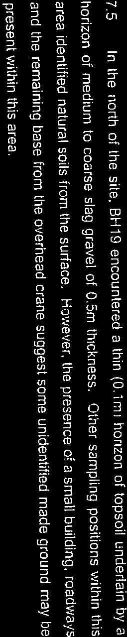
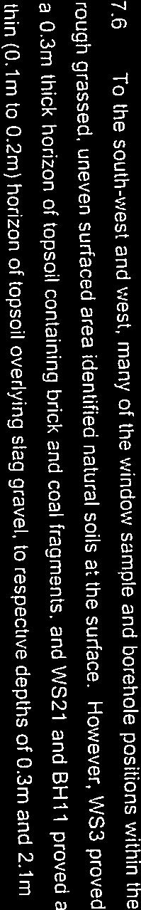
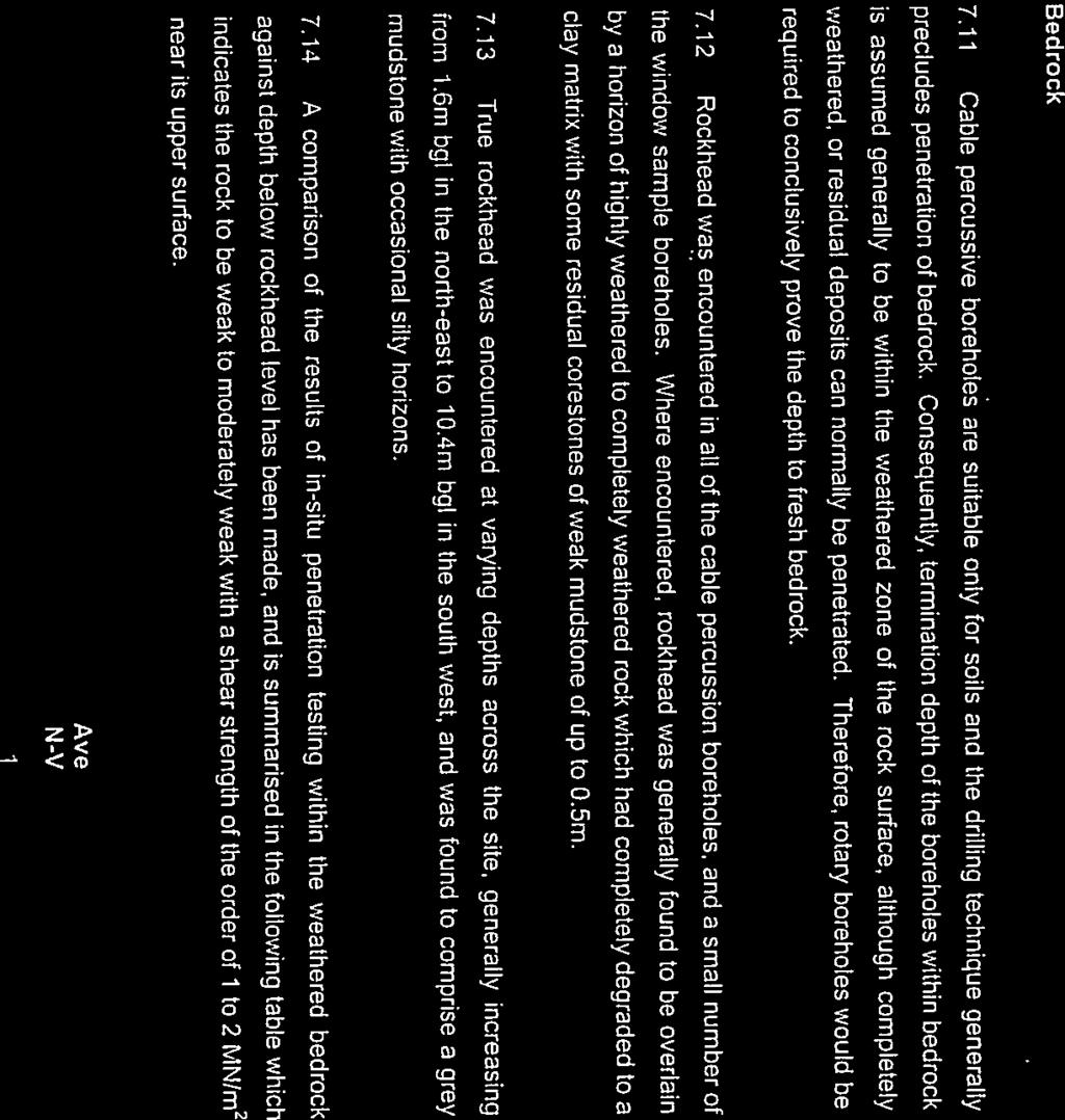
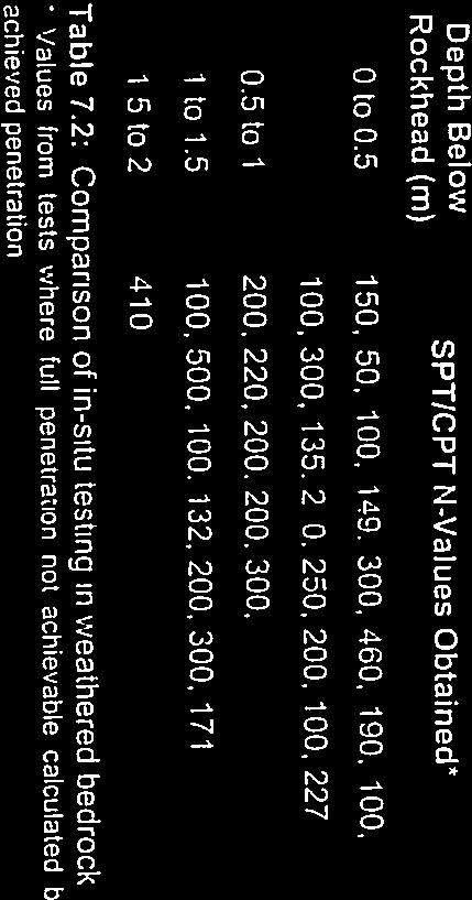
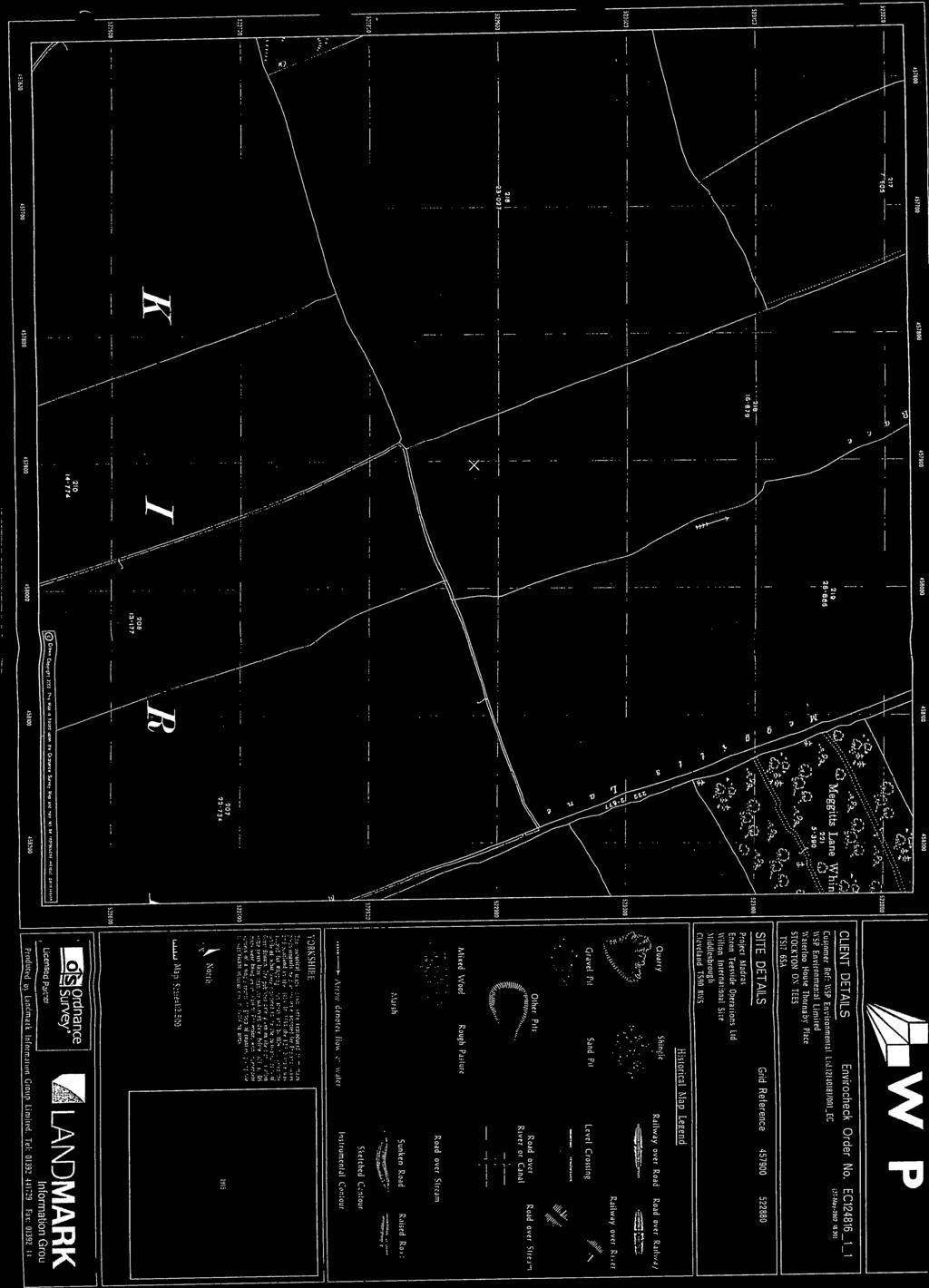
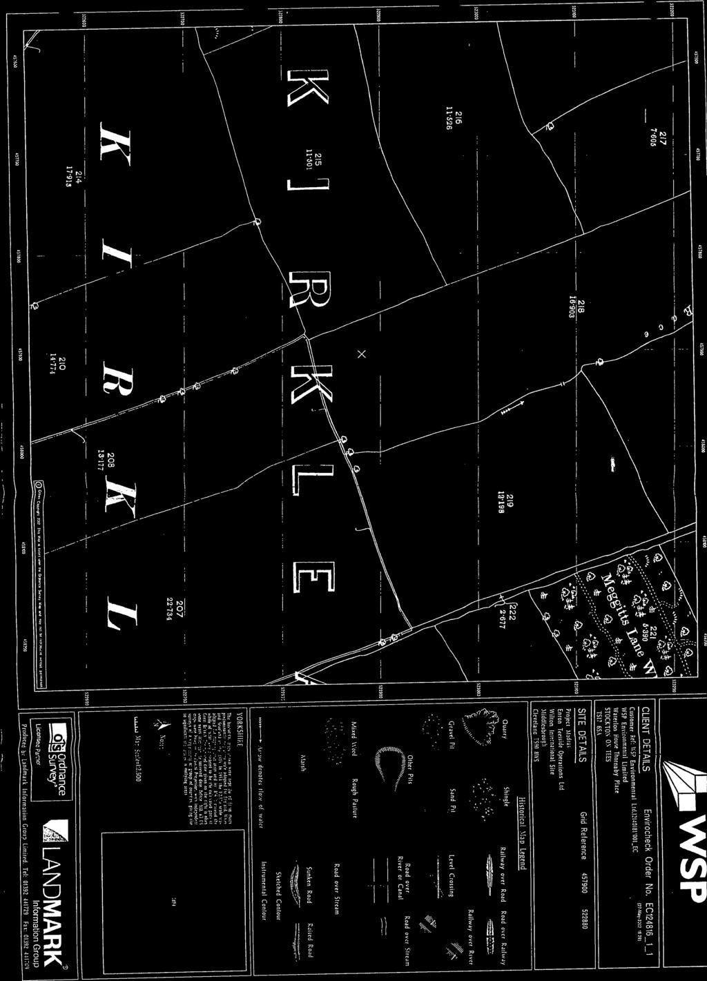
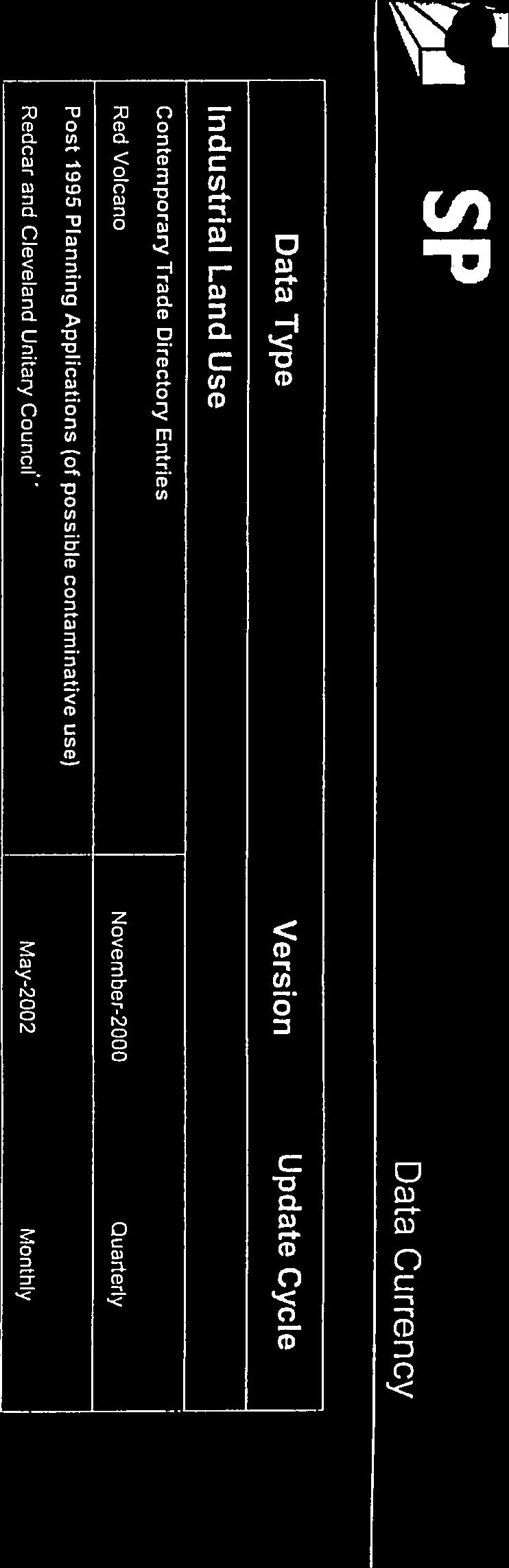
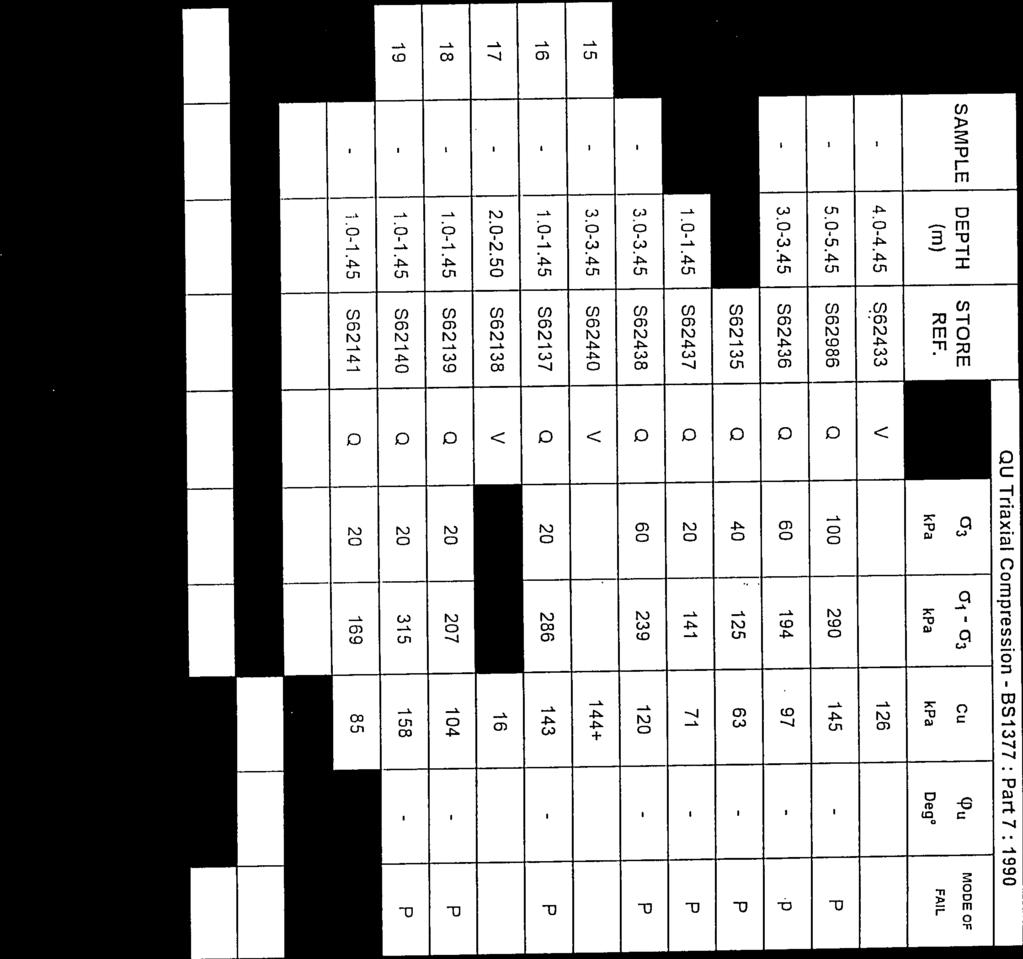
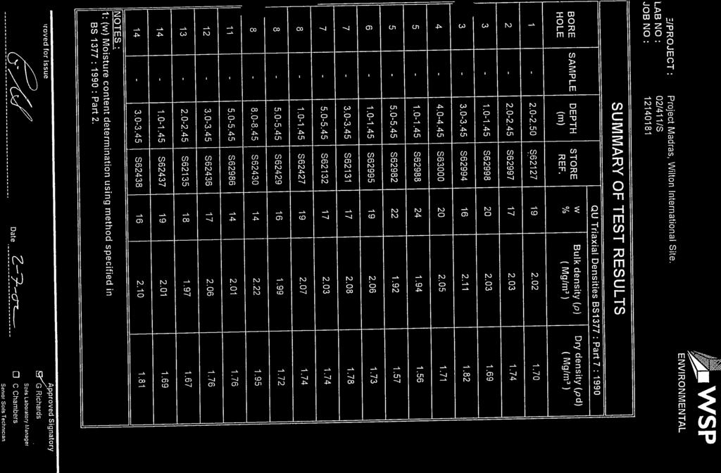
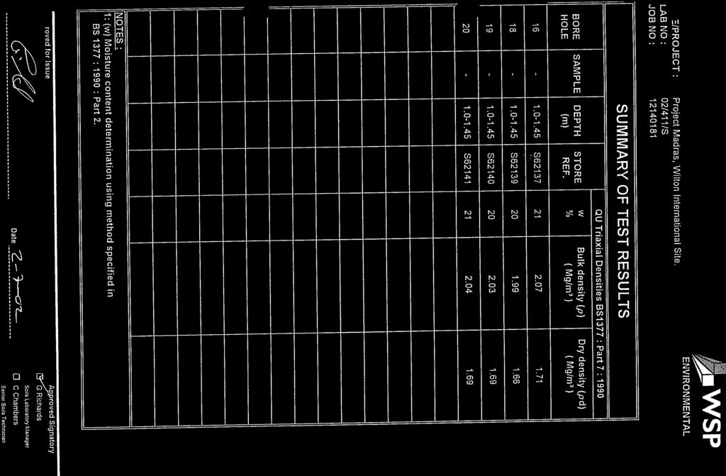
Map Name(s) and Date(s) Russian Map - Slice A. Order Details. Site Details Wilton Site, Middlesbrough, Cleveland, TS8 9JA
|
|
|
- Beatrice Matthews
- 6 years ago
- Views:
Transcription

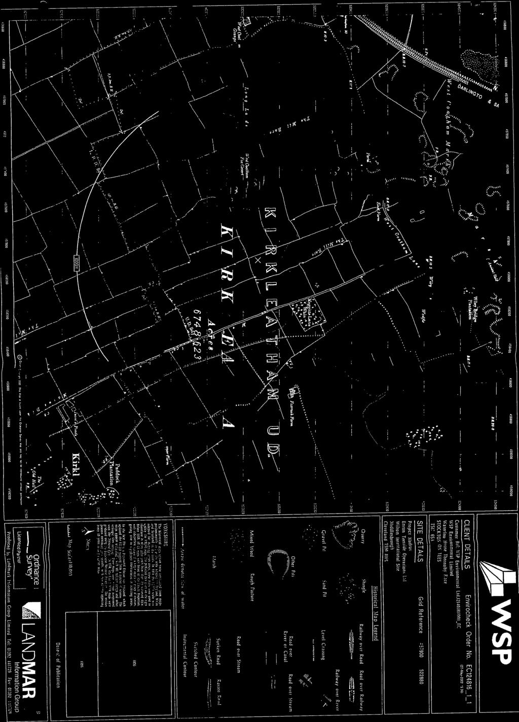
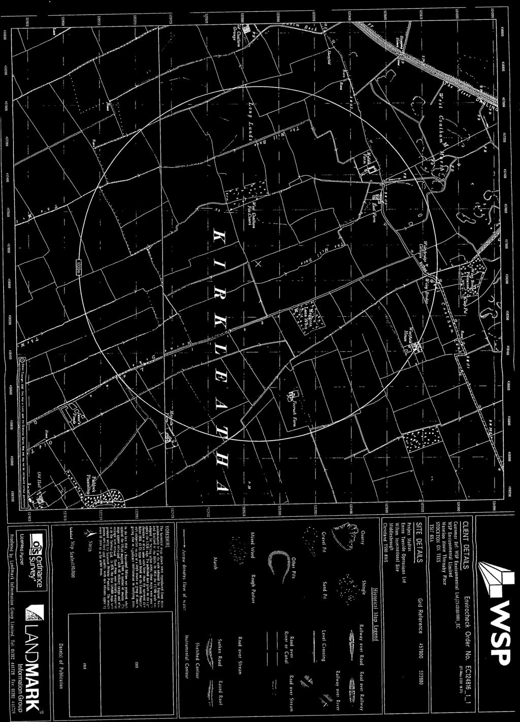
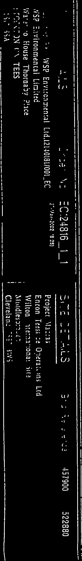
1 Middlesbrough Published 1991 Source map scale - 1:25,000 These maps were produced by the Russian military during the Cold War between 1950 and 1997, and cover 103 towns and cities throughout the U.K. The maps are produced at 1:25,000, 1:10,000 and 1:5,000 scale, and show detailed land use, with colour-coded areas for development, green areas, and non-developed areas. Buildings are coloured black and important building uses (such as hospitals, post offices, factories etc.) are numbered, with a numbered key describing their use. They were produced by the Russians for the benefit of navigation, as well as strategic military sites and transport hubs, for use if they were to have invaded the U.K. The detailed information provided indicates that the areas were surveyed using land-based personnel, on the ground, in the cities that are mapped. Map Name(s) and Date(s) Russian Map - Slice A Order Details Order Number: _1_1 Customer Ref: 9Y National Grid Reference: , Slice: A Site Area (Ha): Search Buffer (m): 500 Site Details Wilton Site, Middlesbrough, Cleveland, TS8 9JA Tel: Fax: Web: A Landmark Information Group Service v Jan-2014 Page 12 of 15


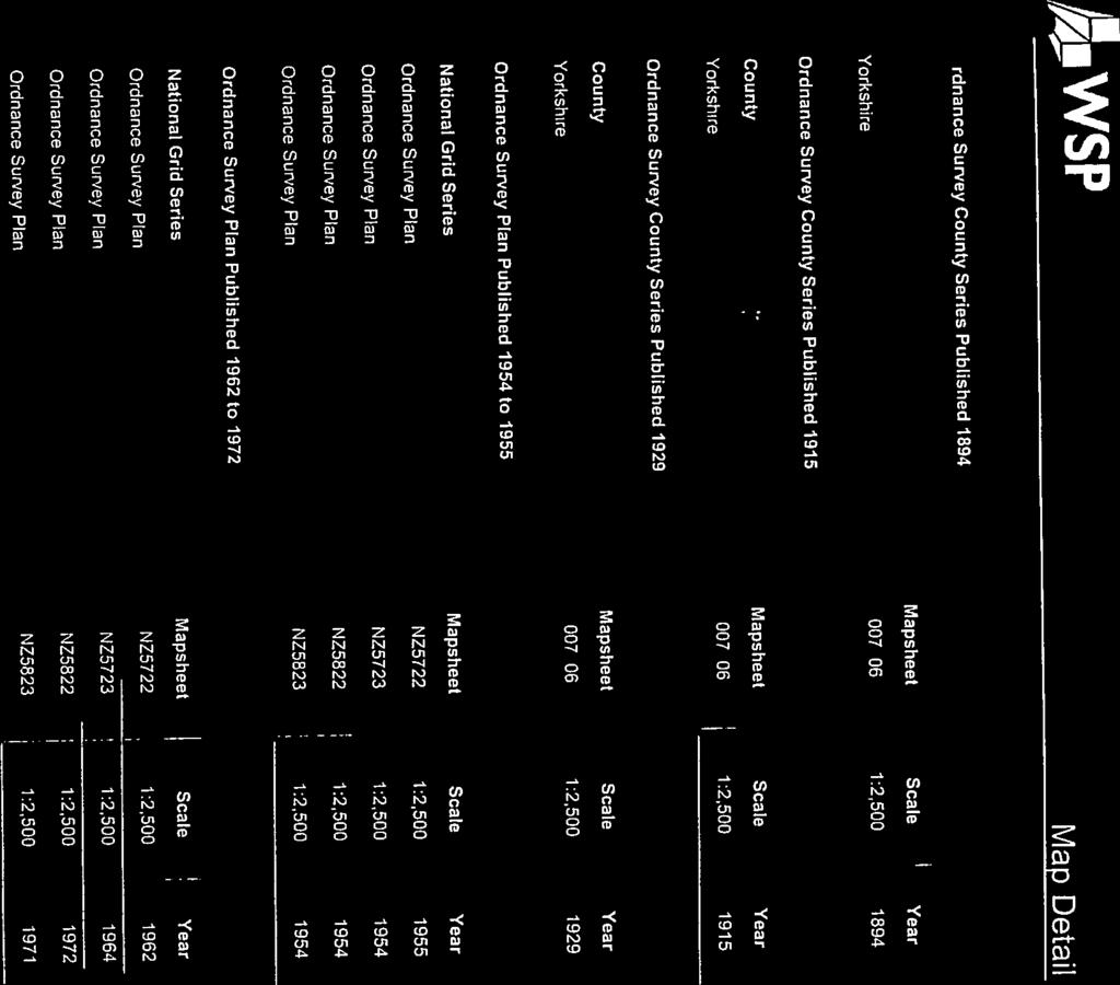
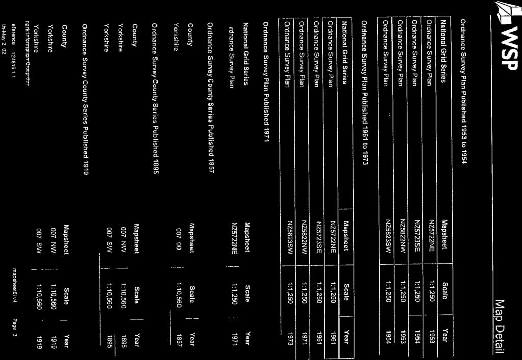
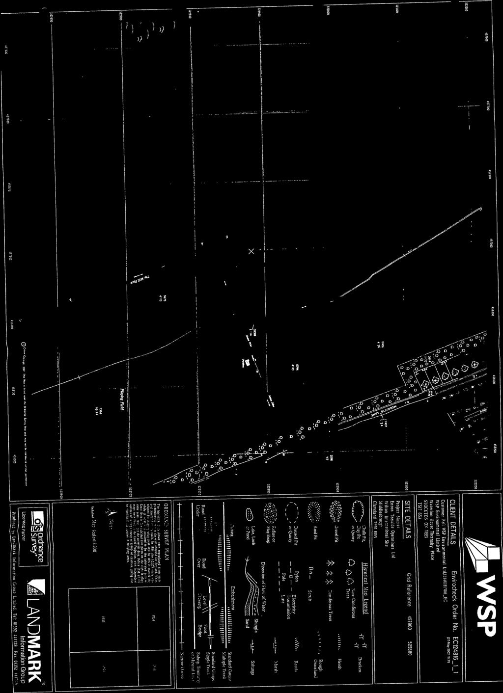
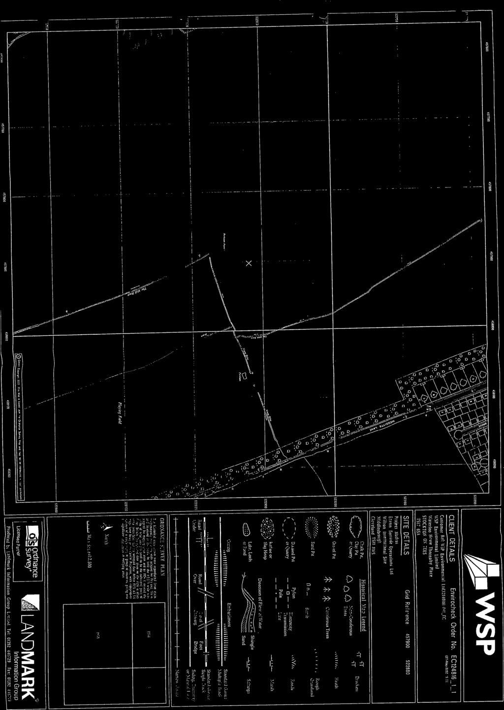
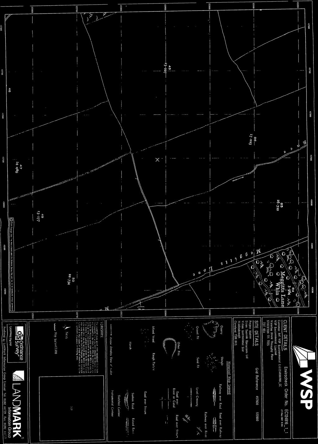
2 Ordnance Survey Plan Published 1992 Source map scale - 1:10,000 The historical maps shown were reproduced from maps predominantly held at the scale adopted for England, Wales and Scotland in the 1840`s. In 1854 the 1:2,500 scale was adopted for mapping urban areas; these maps were used to update the 1:10,560 maps. The published date given therefore is often some years later than the surveyed date. Before 1938, all OS maps were based on the Cassini Projection, with independent surveys of a single county or group of counties, giving rise to significant inaccuracies in outlying areas. In the late 1940`s, a Provisional Edition was produced, which updated the 1:10,560 mapping from a number of sources. The maps appear unfinished - with all military camps and other strategic sites removed. These maps were initially overprinted with the National Grid. In 1970, the first 1:10,000 maps were produced using the Transverse Mercator Projection. The revision process continued until recently, with new editions appearing every 10 years or so for urban areas. Map Name(s) and Date(s) Historical Map - Slice A Order Details Order Number: _1_1 Customer Ref: 9Y National Grid Reference: , Slice: A Site Area (Ha): Search Buffer (m): 500 Site Details Wilton Site, Middlesbrough, Cleveland, TS8 9JA Tel: Fax: Web: A Landmark Information Group Service v Jan-2014 Page 13 of 15

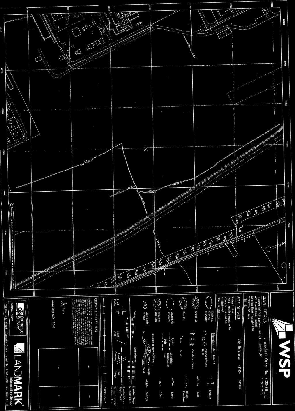
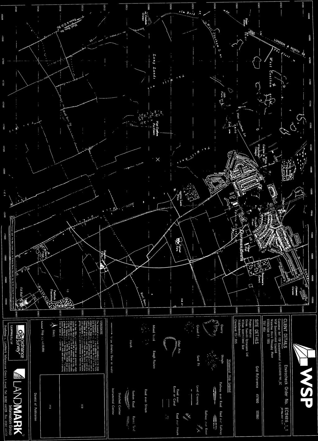
3 dummy 10k Raster Mapping Published 2006 Source map scale - 1:10,000 The historical maps shown were produced from the Ordnance Survey`s 1:10,000 colour raster mapping. These maps are derived from Landplan which replaced the old 1:10,000 maps originally published in The data is highly detailed showing buildings, fences and field boundaries as well as all roads, tracks and paths. Road names are also included together with the relevant road number and classification. Boundary information depiction includes county, unitary authority, district, civil parish and constituency. Map Name(s) and Date(s) Historical Map - Slice A Order Details Order Number: _1_1 Customer Ref: 9Y National Grid Reference: , Slice: A Site Area (Ha): Search Buffer (m): 500 Site Details Wilton Site, Middlesbrough, Cleveland, TS8 9JA Tel: Fax: Web: A Landmark Information Group Service v Jan-2014 Page 14 of 15
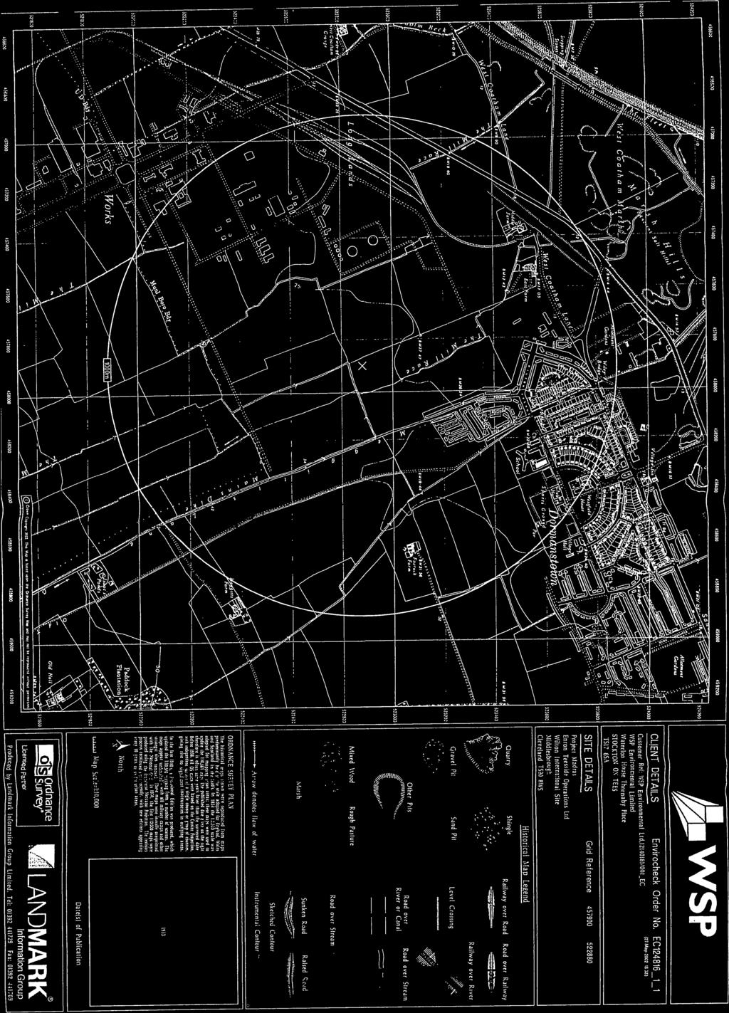
4 10k Raster Mapping Published 2013 Source map scale - 1:10,000 The historical maps shown were produced from the Ordnance Survey`s 1:10,000 colour raster mapping. These maps are derived from Landplan which replaced the old 1:10,000 maps originally published in The data is highly detailed showing buildings, fences and field boundaries as well as all roads, tracks and paths. Road names are also included together with the relevant road number and classification. Boundary information depiction includes county, unitary authority, district, civil parish and constituency. Map Name(s) and Date(s) Historical Map - Slice A Order Details Order Number: _1_1 Customer Ref: 9Y National Grid Reference: , Slice: A Site Area (Ha): Search Buffer (m): 500 Site Details Wilton Site, Middlesbrough, Cleveland, TS8 9JA Tel: Fax: Web: A Landmark Information Group Service v Jan-2014 Page 15 of 15
5 Appendix C Site Walk Over Photo Survey York Potash Land Quality Preliminary Risk Assessment HaskoningUK Ltd 22


6 Site entrance and Woodchip storage area Derelict/Empty building Derelict/Empty building View South toward Derelict/Empty building View South toward Woodchip storage area View North towards material stockpile York Potash - Wilton Appendix C 9Y0989 Final Report March 2014


7 Field drain Field drain View North towards material stockpile View from material stockpile View from material stockpile Railway line/site boundary York Potash - Wilton Appendix C 9Y0989 Final Report March 2014
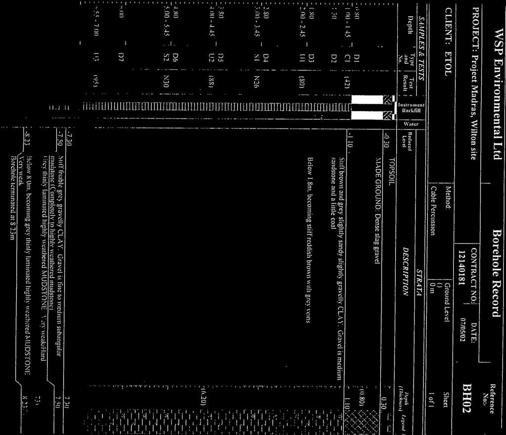
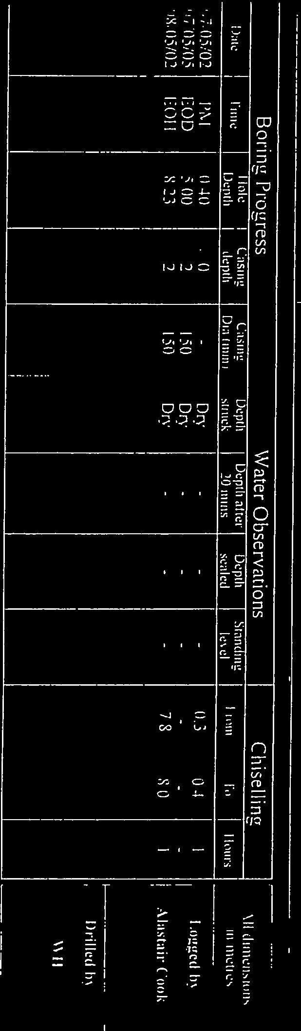
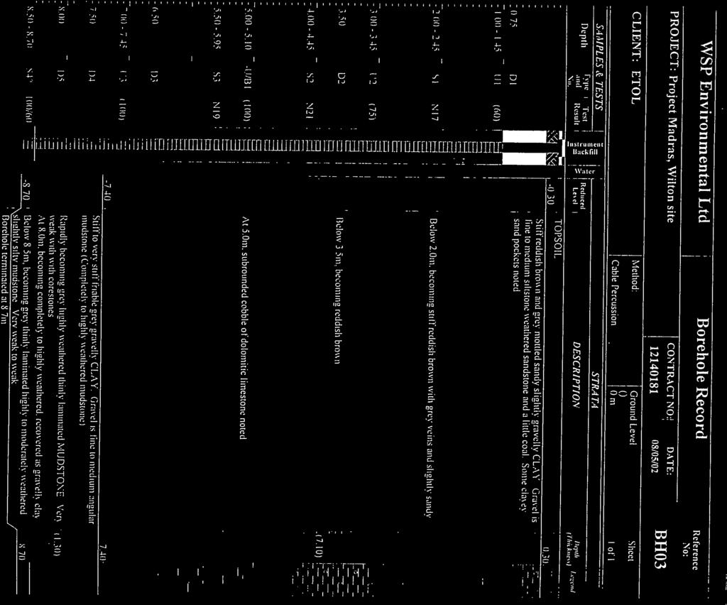
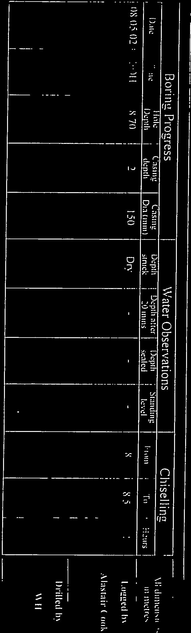
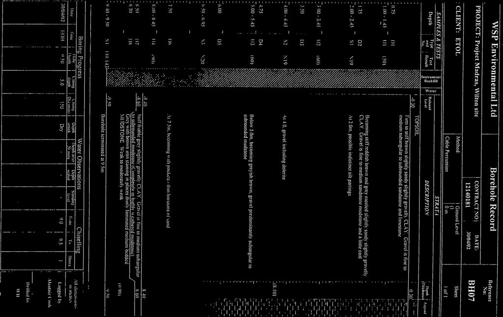
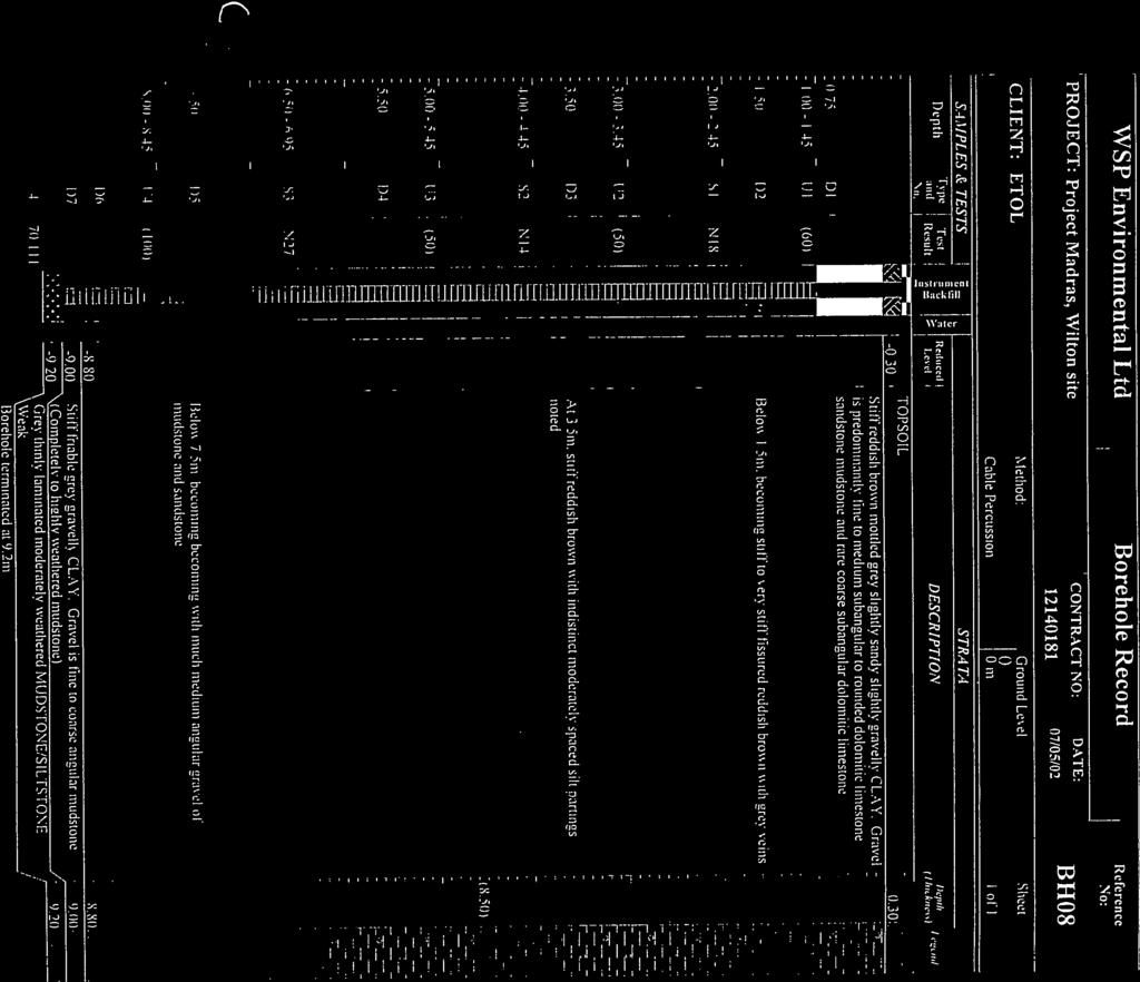
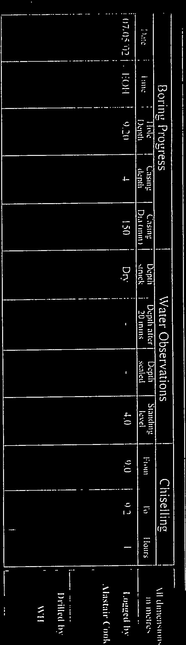
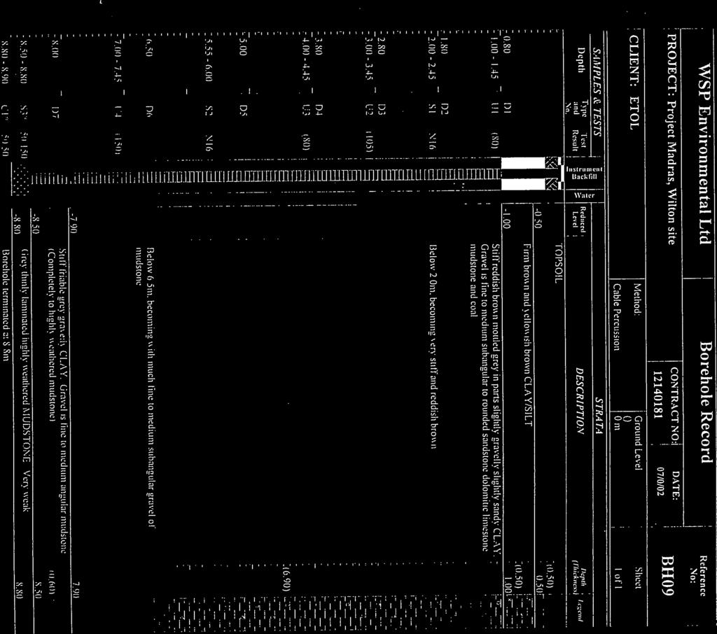
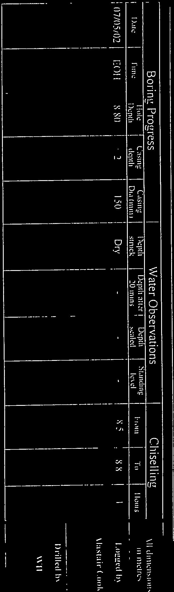
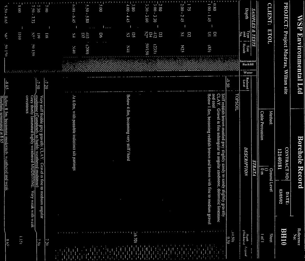
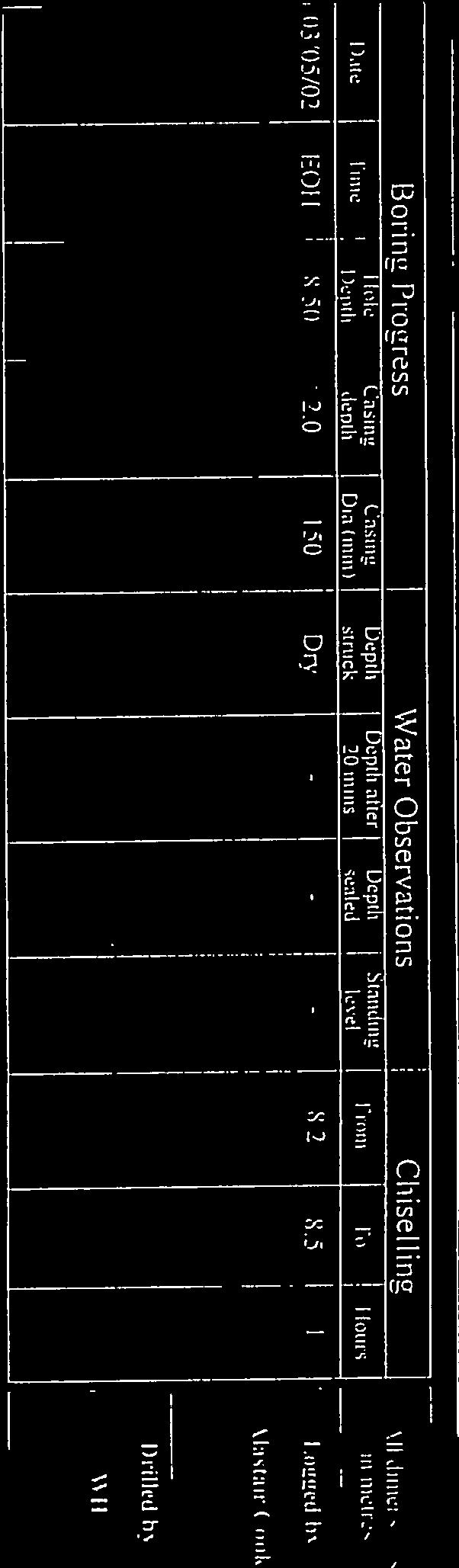
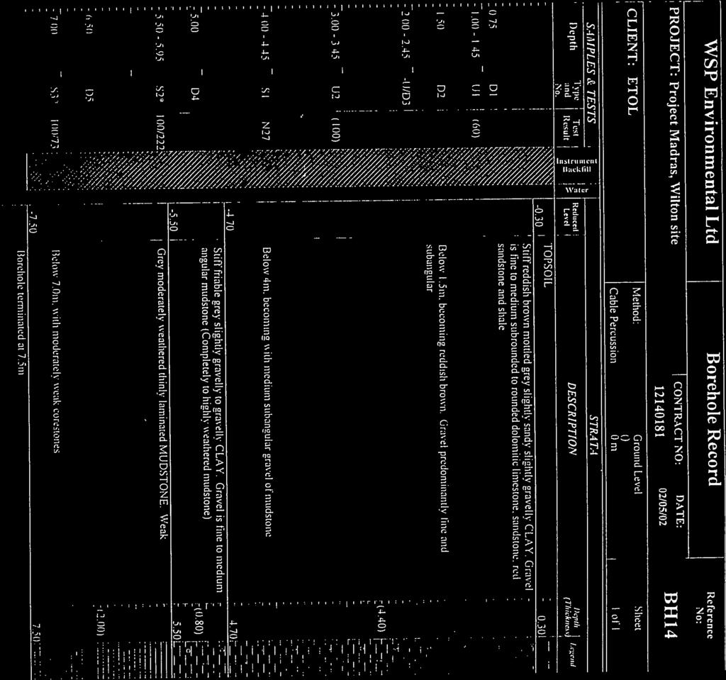
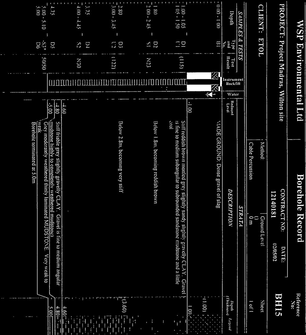
8 Appendix D BGS Logs York Potash Land Quality Preliminary Risk Assessment HaskoningUK Ltd 23
9
10
11
12
13 Appendix E Previous Ground Investigation York Potash Land Quality Preliminary Risk Assessment HaskoningUK Ltd 24


14
15
16

17


18

19
20
21
22
23

24

25

26

27
28

29

30

31
32

33


34

35

36

37


38

39

40

41
42

43


44
45

46

47
48

49


50

51

52


53

54
55

56

57


58

59
60

61
62
63
64


65
66
67


68
69
70


71
72
73
74

75

76


77


78
79
80
81
82
83
84
85
86
87
88
89
90
91
92
93
94

95

96

97

98

99
100
101


102
103
104
105
106
107

108
109
110
111
112
113

114

115
116

117
118
119
120
121
122
123
124


125
126
127
128

129

130
131
132
133
134
135


136
137
138
139
140
141
142

143
144
145
146

147
148

149

150
151
152
153
154

155
156
157


158
159
160
161

162

163

164

165
166 Appendix F Limitations York Potash Land Quality Preliminary Risk Assessment HaskoningUK Ltd 25

167 Limitations The direct assessments and judgements given in this report are limited by both the finite data on which they are based and the proposed works to which they are addressed. The acquisition of data is constrained by both physical and economic factors and, by definition, is subject to limitations. Conditions at the site will change over time due to natural variations and may be affected by human activities. This document has been prepared for the titled project and should not be relied upon or used for any other project. Royal HaskoningDHV accepts no responsibility or liability for the consequences of this document being used for a purpose other than that purpose for which it was commissioned. The assessments and judgements contained herein should not be relied upon as legal opinion. The findings and opinions are relevant to the dates of the information reviewed and should not be relied upon to represent conditions at later dates. The opinions included herein are based on the information obtained from the assessments undertaken in the study area and from the experience of the reviewers. This Phase I Land Quality Assessment has utilised a variety of publicly available data sources such as the Environment Agency, Landmark Group, historical maps and the British Geological Survey. Therefore, the study is limited by the age and limitations inherent in the data described. York Potash Land Quality Preliminary Risk Assessment HaskoningUK Ltd 26
Russian Military Mapping Legends
 Russian Military Mapping Legends 1:5,000 and 1:10,000 mapping 1:25,000 mapping Key to Numbers on Mapping Historical Mapping & Photography included: NZ52_Middlesbrough No. Description 52 Factories (Chemicals)
Map Name(s) and Date(s) Historical Map - Slice A
 and Date(s) Historical Map - Slice A") Ordnance Survey Plan Published 1975 The historical maps shown were reproduced from maps predominantly held at the scale adopted for England, Wales and Scotland in the 1840`s. In 1854 the 1:2,500 scale
Ordnance Survey Plan Published 1975 The historical maps shown were reproduced from maps predominantly held at the scale adopted for England, Wales and Scotland in the 1840`s. In 1854 the 1:2,500 scale
Map Name(s) and Date(s) Historical Map - Slice A. Order Details. Site Details Land Adjacent to Village Green, Templeton, NARBERTH, Dyfed
 and Date(s) Historical Map - Slice A. Order Details. Site Details Land Adjacent to Village Green, Templeton, NARBERTH, Dyfed") Pembrokeshire Published 1953 Source map scale - 1:10,560 The historical maps shown were reproduced from maps predominantly held at the scale adopted for England, Wales and Scotland in the 1840`s. In 1854
Pembrokeshire Published 1953 Source map scale - 1:10,560 The historical maps shown were reproduced from maps predominantly held at the scale adopted for England, Wales and Scotland in the 1840`s. In 1854
Large-Scale National Grid Data. Source map scale - 1:1,250. Published Historical Map - Segment A13. Map Name(s) and Date(s)
 and Date(s)") Large-Scale National Grid Data Published 1993 Source map scale - 1:1,250 'Large Scale National Grid Data' superseded SIM cards (Ordnance Survey's 'Survey of Information on Microfilm') in 1992, and continued
Large-Scale National Grid Data Published 1993 Source map scale - 1:1,250 'Large Scale National Grid Data' superseded SIM cards (Ordnance Survey's 'Survey of Information on Microfilm') in 1992, and continued
Map Name(s) and Date(s) Historical Map - Segment A13. Order Details Order Number: Customer Ref:
 and Date(s) Historical Map - Segment A13. Order Details Order Number: Customer Ref:") Published 1975-1989 Source map scale - 1:1,250 The historical maps shown were reproduced from maps predominantly held at the scale adopted for England, Wales and Scotland in the 1840`s. In 1854 the 1:2,500
Published 1975-1989 Source map scale - 1:1,250 The historical maps shown were reproduced from maps predominantly held at the scale adopted for England, Wales and Scotland in the 1840`s. In 1854 the 1:2,500
Map Name(s) and Date(s) Historical Map - Segment A13. Order Details. Site Details 459 Dover Road, Walmer, DEAL, Kent, CT14 7PG. Customer Ref: 28927
 and Date(s) Historical Map - Segment A13. Order Details. Site Details 459 Dover Road, Walmer, DEAL, Kent, CT14 7PG. Customer Ref: 28927") Ordnance Survey Plan Published 1973-1974 Source map scale - 1:1,250 The historical maps shown were reproduced from maps predominantly held at the scale adopted for England, Wales and Scotland in the 1840`s.
Ordnance Survey Plan Published 1973-1974 Source map scale - 1:1,250 The historical maps shown were reproduced from maps predominantly held at the scale adopted for England, Wales and Scotland in the 1840`s.
Map Name(s) and Date(s) Historical Map - Slice B. Order Details. Site Details Site at, Bicester, Oxfordshire
 and Date(s) Historical Map - Slice B. Order Details. Site Details Site at, Bicester, Oxfordshire") Published 1996 Source map scale - used to update the maps. The published date given therefore is were based on the assini Projection, with independent surveys of a single the mapping from a number of sources.
Published 1996 Source map scale - used to update the maps. The published date given therefore is were based on the assini Projection, with independent surveys of a single the mapping from a number of sources.
Map Name(s) and Date(s) Historical Map - Segment A13. Order Details
 and Date(s) Historical Map - Segment A13. Order Details") dditional SIMs Published 1960-1990 Source map scale - 1:1,250 The SIM cards (Ordnance Survey's `Survey of Information on Microfilm') are further, minor editions of mapping which were produced and published
dditional SIMs Published 1960-1990 Source map scale - 1:1,250 The SIM cards (Ordnance Survey's `Survey of Information on Microfilm') are further, minor editions of mapping which were produced and published
Historical Mapping Legends
 Historical Mapping Legends Ordnance Survey County Series and Ordnance Survey Plan 1:2,500 Ordnance Survey Plan, dditional SIMs and Supply of Unpublished Survey Information 1:2,500 and Large-Scale National
Document Reference: /2014
 Ground and Environmental Services Limited Unit Montpelier Business Park Dencora Way Ashford Kent TN3 4FG 0133 437 Riverpark Gardens Bromley Kent Phase 1 Contamination Risk Assessment On behalf of Abstruct
Map Name(s) and Date(s) Historical Map - Slice A
 and Date(s) Historical Map - Slice A") VectorMap Local Published 2016 Source map scale - 1:10,000 VectorMap Local (Raster) is Ordnance Survey's highest detailed 'backdrop' mapping product. These maps are produced from OS's VectorMap Local,
VectorMap Local Published 2016 Source map scale - 1:10,000 VectorMap Local (Raster) is Ordnance Survey's highest detailed 'backdrop' mapping product. These maps are produced from OS's VectorMap Local,
Historical Mapping Legends
 Historical Mapping Legends Ordnance Survey County Series and Ordnance Survey Plan Ordnance Survey Plan, dditional SIMs and Supply of Unpublished Survey Information and 1:1,250 Large-Scale National Grid
Historical Mapping Legends
 Historical Mapping Legends Ordnance Survey County Series and Ordnance Survey Plan Ordnance Survey Plan, dditional SIMs and Supply of Unpublished Survey Information and 1:1,250 Large-Scale National Grid
User Guide: RADON POTENTIAL DATASET - England and Wales
 User Guide: RADON POTENTIAL DATASET - England and Wales This document provides information for users of the joint HPA-BGS RADON POTENTIAL DATASET for England and Wales. 1. Background to joint Health Protection
Land-Line Technical information leaflet
 Land-Line Technical information leaflet The product Land-Line is comprehensive and accurate large-scale digital mapping available for Great Britain. It comprises nearly 229 000 separate map tiles of data
Historical Mapping Legends
 Historical Mapping Legends Ordnance Survey County Series and Ordnance Survey Plan 1:2,500 Ordnance Survey Plan, Additional SIMs and Supply of Unpublished Survey Information 1:2,500 and Large-Scale National
APPENDIX D REGION 5 ALL HAZARD MITIGATION PLAN EDITION PIERCE COUNTY OVERVIEW. Inherent Errors
 APPENDIX D REGION 5 ALL HAZARD MITIGATION PLAN 2015-2020 EDITION PIERCE COUNTY OVERVIEW This appendix contains the spatial results from the Hazus Earthquake Scenario results showing the Essential Facilities
RURAL SETTLEMENT PATTERNS AND ACCESS TO DEVELOPMENT LAND: DEVELOPING THE EVIDENCE BASE
 School of Planning, Architecture and Civil Engineering RURAL SETTLEMENT PATTERNS AND ACCESS TO DEVELOPMENT LAND: DEVELOPING THE EVIDENCE BASE Prepared for Friends of the Earth Northern Ireland 18 th April
Frequently Asked Questions about MnDOT s Railroad Map Conversion Project
 Frequently Asked Questions about MnDOT s Railroad Map Conversion Project What were the main objectives of the project? What are the results and end products? What can these railroad maps be used for? Who
GIS = Geographic Information Systems;
 What is GIS GIS = Geographic Information Systems; What Information are we talking about? Information about anything that has a place (e.g. locations of features, address of people) on Earth s surface,
Introduction to GIS. Dr. M.S. Ganesh Prasad
 Introduction to GIS Dr. M.S. Ganesh Prasad Department of Civil Engineering The National Institute of Engineering, MYSORE ganeshprasad.nie@gmail.com 9449153758 Geographic Information System (GIS) Information
British Household Panel Survey, waves 1-17 ( )
") UK Data Archive Study Number 6032 - British Household Panel Survey, Waves 1-17, 1991-2008: Conditional Access, Rural-Urban s British Household Panel Survey, waves 1-17 (1991-2008) User Documentation: Rural-Urban
UK Data Archive Study Number 6032 - British Household Panel Survey, Waves 1-17, 1991-2008: Conditional Access, Rural-Urban s British Household Panel Survey, waves 1-17 (1991-2008) User Documentation: Rural-Urban
30 Broad Street, Wokingham, Berkshire
 30 Broad Street, Wokingham, Berkshire An Archaeological Watching Brief for Psilogic Ltd by Steve Ford Thames Valley Archaeological Services Ltd Site Code 30BSW01/81 October 2001 Summary Site name: 30 Broad
McHenry County Property Search Sources of Information
 Disclaimer: The information in this system may contain inaccuracies or typographical errors. The information in this system is a digital representation of information derived from original documents; as
INSPIRE in the context of EC Directive 2002/49/EC on Environmental Noise
 INSPIRE in the context of EC Directive 2002/49/EC on Environmental Noise Simon Shilton Acustica Ltd, United Kingdom Nigel Jones Extrium Ltd, United Kingdom About the Authors www.acustica.co.uk Acoustics
Digital Wetlands. Bringing the Field into the Office Through GIS
 Digital Wetlands Bringing the Field into the Office Through GIS Maryland Department of the Environment Wetlands and Waterways Program MDE's Wetlands and Waterways Program seeks to conserve valuable aquatic
ARCHAEOLOGICAL S E R V I C E S. 1 Beechmount Road, Southampton, Hampshire. Archaeological Watching Brief. by David Platt. Site Code: SOU1649
 T H A M E S V A L L E Y ARCHAEOLOGICAL S E R V I C E S 1 Beechmount Road, Southampton, Hampshire Archaeological Watching Brief by David Platt Site Code: SOU1649 (SU 4188 1616) 1 Beechmount Road, Southampton,
Exploring Digital Welfare data using GeoTools and Grids
 Exploring Digital Welfare data using GeoTools and Grids Hodkinson, S.N., Turner, A.G.D. School of Geography, University of Leeds June 20, 2014 Summary As part of the Digital Welfare project [1] a Java
GEO-INFORMATICS AND SPACE TECHNOLOGY FOR PROPERTIES DIGITAL TAX MAP : CASE STUDY ON LOCAL ADMINISTRATIVE WONG KONG MUNICIPALITY, PHITSANULOK, THAILAND
 GEO-INFORMATICS AND SPACE TECHNOLOGY FOR PROPERTIES DIGITAL TAX MAP : CASE STUDY ON LOCAL ADMINISTRATIVE WONG KONG MUNICIPALITY, PHITSANULOK, THAILAND Vicharn Amarakul Regional Center of Geo-Informatics
Monthly Magnetic Bulletin
 BRITISH GEOLOGICAL SURVEY Fort McMurray Observatory Monthly Magnetic Bulletin March 2017 17/03/FM Fort McMurray FORT McMURRAY OBSERVATORY MAGNETIC DATA 1. Introduction The British Geological Survey (BGS)
Mining & Ground Stability Report User Guide
 Mining & Report User Guide for the Environmental Professional. A comprehensive guide to Envirocheck reports, products and services. 1 User Guide Contents 3 1. Introduction to Envirocheck 4 2. The Envirocheck
Monthly Magnetic Bulletin
 BRITISH GEOLOGICAL SURVEY Ascension Island Observatory Monthly Magnetic Bulletin March 2017 17/03/AS Crown copyright; Ordnance Survey ASCENSION ISLAND OBSERVATORY MAGNETIC DATA 1. Introduction Ascension
Auckland Transport. Auckland Council. Statement of Evidence of Simon John Ferneyhough
 Under the Resource Management Act 1991 In the matter of Notices of Requirement to enable the construction, operation and maintenance of the City Rail Link Between Auckland Transport Requiring Authority
Write a report (6-7 pages, double space) on some examples of Internet Applications. You can choose only ONE of the following application areas:
 on some examples of Internet Applications. You can choose only ONE of the following application areas:") UPR 6905 Internet GIS Homework 1 Yong Hong Guo September 9, 2008 Write a report (6-7 pages, double space) on some examples of Internet Applications. You can choose only ONE of the following application
UPR 6905 Internet GIS Homework 1 Yong Hong Guo September 9, 2008 Write a report (6-7 pages, double space) on some examples of Internet Applications. You can choose only ONE of the following application
Land Administration and Cadastre
 Geomatics play a major role in hydropower, land and water resources and other infrastructure projects. Lahmeyer International s (LI) worldwide projects require a wide range of approaches to the integration
REGIONAL TRANSIT AUTHORITY. RTA TaskForce. John G. Johnson, Executive Director Association of Central Oklahoma Governments
 REGIONAL TRANSIT AUTHORITY TaskForce John G. Johnson, Executive Director Association of Central Oklahoma Governments February 17, 2016 RECAP on the RTD Boundary Scenarios RECAP REGIONAL TRANSIT DIALOGUE
Space for Smarter Government Programme
 Space for Smarter Government Programme Development of Operational National Satellite Imaging Flood Mapping Capability Project Number: 59287-454144 Web: http://www.spaceforsmartergovernment.uk/ Email: ssgp@sa.catapult.org.uk
HertfordshireCC GIS Standards (draft) Contents
 Contents") Standards for Geographic Information Systems Contents Requirements for the procurement of systems with mapping/gis functionality...2 Background...2 System Requirements...2 HCC Corporate Standard for Spatial
Standards for Geographic Information Systems Contents Requirements for the procurement of systems with mapping/gis functionality...2 Background...2 System Requirements...2 HCC Corporate Standard for Spatial
A new type of RICEPOTS
 A new type of RICEPOTS Alan Parkinson Geography teaching resource College Crown Copyright and Database Right 2014. Ordnance Survey (Digimap Licence) This is one of a series of teaching resources for use
Source Protection Zones. National Dataset User Guide
 Source Protection Zones National Dataset User Guide Version 1.1.4 20 th Jan 2006 1 Contents 1.0 Record of amendment...3 2.0 Introduction...4 2.1 Description of the SPZ dataset...4 2.1.1 Definition of the
PostPoint Professional
 PostPoint Professional 2014.02 PRODUCT GUIDE Information in this document is subject to change without notice and does not represent a commitment on the part of the vendor or its representatives. part
UNCLASSIFIED. Risk of Flooding from Reservoirs - Western Wales River Basin District
 UNCLASSIFIED Flood Risk Maps Risk of Flooding from Reservoirs - Western Wales Why have we produced these maps what can they be used for? Under the Flood Risk Regulations Natural Resources Wales have worked
The Governance of Land Use
 The planning system The Governance of Land Use United Kingdom Levels of government and their responsibilities The United Kingdom is a unitary state with three devolved governments in Northern Ireland,
UNCLASSIFIED. Risk of Flooding from Rivers and Sea - Western Wales River Basin District
 UNCLASSIFIED Flood Risk Maps Risk of Flooding from Rivers and Sea - Western Wales Why have we produced these maps what can they be used for? Under the Flood Risk Regulations Natural Resources Wales have
Flood Map. National Dataset User Guide
 Flood Map National Dataset User Guide Version 1.1.5 20 th April 2006 Copyright Environment Agency 1 Contents 1.0 Record of amendment... 3 2.0 Introduction... 4 2.1 Description of the Flood Map datasets...4
Oxford Options Resource Centre, Horspath Driftway, Headington, Oxford
 Oxford Options Resource Centre, Horspath Driftway, Headington, Oxford An Archaeological Watching Brief For Oxfordshire County Council by Tim Dawson and Heather Hopkins Thames Valley Archaeological Services
Efficiencies in Data Acquisition and Transformation
 Efficiencies in Data Acquisition and Transformation Andrew LEYZACK Canada Key words: Hydrography, IHO S-57, Nautical Chart SUMMARY For many hydrographic offices, the introduction of electronic nautical
Laurier Centre for Military Strategic and Disarmament Studies
 Laurier Centre for Military Strategic and Disarmament Studies Finding Aid - (MG-0036) Generated by Access to Memory (AtoM) 2.3.1 Printed: August 24, 2017 Language of description: English Laurier Centre
Topographic Strategy National Topographic Office March 2015
 www.linz.govt.nz Topographic Strategy National Topographic Office March 2015 >> Foreword Topographic information is vital to understanding our country and its assets, and for supporting economic development.
Specification & Content of Marine Reference Information
 Specification & Content of Marine Reference Information By Mike Osborne and James Rapaport SeaZone Solutions Limited CONTENTS 1. History of Marine Data 2. User Requirements 3. Geographic Content 4. SeaZone
YEAR 7 REVISION BOOKLET
 YEAR 7 REVISION BOOKLET Assessment checklist 1. To be able to define Geography. 2. Give examples of what we study in geography 3. Group what we study into the three major areas of geography 4. To be able
TOWARDS STRATEGIC SPATIAL PLANNING IN JAMAICA: THE NATIONAL SPATIAL PLAN
 TOWARDS STRATEGIC SPATIAL PLANNING IN JAMAICA: THE NATIONAL SPATIAL PLAN JIEP 5th Biennial Conference on the Environment: Balancing National Development and Environmental Protection June 6, 2011 Jamaica
Archaeological Evaluation of Land off Hubbards Lane, Boughton Monchelsea, Kent
 Archaeological Evaluation of Land off Hubbards Lane, Boughton Monchelsea, Kent NGR: 576190 151300 Site Code: HUB/EV/16 (Planning Application: 16/500014/OUT/MA) SWAT Archaeology The Office, School Farm
Roman Farm, Nettleden, Hemel Hempstead, Hertfordshire
 Roman Farm, Nettleden, Hemel Hempstead, Hertfordshire An Archaeological Watching Brief for Mercantile Land Development Ltd by Siân Anthony Thames Valley Archaeological Services Ltd Site Code RFN01/82 October
Monthly Magnetic Bulletin
 BRITISH GEOLOGICAL SURVEY Fort McMurray Observatory Monthly Magnetic Bulletin February 2016 16/02/FM Fort McMurray FORT McMURRAY OBSERVATORY MAGNETIC DATA 1. Introduction The British Geological Survey
presents challenges related to utility infrastructure planning. Many of these challenges
 1 Introduction: - a. Purpose According to U.S. Census Bureau the population of stark county was 367,585 in 1990, and in 2000 it was increase to 378,098. Thus County is experiencing a growth that presents
Land adjacent to 103 Pound Lane, Sonning, Berkshire
 Land adjacent to 103 Pound Lane, Sonning, Berkshire An Archaeological Evaluation for Hicks Development Ltd by James McNicoll-Norbury Thames Valley Archaeological Services Ltd Site Code PLS 09/50 June 2009
GIS Monroe Geographic Information System March 14, 2018
 GIS Monroe Geographic Information System March 14, 2018 Goals Maintain Enterprise/County-wide geo-database Increase spatial accuracy of data Build and acquire more data layers Increase use of GIS; as another
Techniques for Science Teachers: Using GIS in Science Classrooms.
 Techniques for Science Teachers: Using GIS in Science Classrooms. After ESRI, 2008 GIS A Geographic Information System A collection of computer hardware, software, and geographic data used together for
PHASE I GEO-ENVIRONMENTAL SITE ASSESSMENT. Former St. Wilfrid s School, Orrell Road/Hawthorne Road, Litherland, Liverpool, L21 8NU
 PHASE I GEO-ENVIRONMENTAL SITE ASSESSMENT Former St. Wilfrid s School, Orrell Road/Hawthorne Road, Litherland, Liverpool, L21 8NU Prepared for: FJH Associates Report Ref: 11-255-R1 Date Issued: E3P Heliport
Orica Australia Pty Ltd Ammonium Nitrate Facility Upgrade
 Orica Australia Pty Ltd Ammonium Nitrate Facility Upgrade January 2010 Revision 0 Contents 1. Introduction 1 1.1 Purpose 1 1.2 Objectives 1 1.3 Relevant Environmental Legislation, Guidelines and Policies
To: Ross Martin, Lisa Stapleton From: Brad Lind Subject: Joint Funding Agreement with USGS for 2012 Imagery Date: March 14, 2012.
 To: Ross Martin, Lisa Stapleton From: Brad Lind Subject: Joint Funding Agreement with USGS for 2012 Imagery Date: March 14, 2012 Attached are two copies of the Joint Funding Agreement (JFA) between SanGIS
Sea Level Space Watch: Service Offering
 Space for Smarter Government Programme Sea Level Space Watch: Service Offering General Sea Level Space Watch : Operational service developed to support national flood defence planning. Systematically updated
Former Cart Shed, Stroud Farm, Holyport, Maidenhead, Berkshire
 Former Cart Shed, Stroud Farm, Holyport, Maidenhead, Berkshire An Archaeological Watching Brief For Mr Simon Rinder by Stephen Hammond and Jennifer Lowe Thames Valley Archaeological Services Ltd Site Code
Assessment and management of at risk populations using a novel GIS based UK population database tool
 Safety and Security Engineering 203 Assessment and management of at risk populations using a novel GIS based UK population database tool H. Balmforth 1, H. McManus 1 & A. Fowler 2 1 Health and Safety Laboratory,
Dorling fbetw.tex V1-04/12/2012 6:10 P.M. Page xi
 Dorling fbetw.tex V1-04/12/2012 6:10 P.M. Page xi List of figures P.1 Born in England, Scotland or Wales Britain 1981 (four levels each), ward map (wards are used to define most other administrative areas
Monthly Magnetic Bulletin
 BRITISH GEOLOGICAL SURVEY Port Stanley Observatory Monthly Magnetic Bulletin July 2011 11/07/PS Jason Islands West Falkland King George Bay Queen Charlotte Bay Weddell Island Caracass Island Saunders Island
McHenry County Property Search Sources of Information
 Disclaimer: The information in this system may contain inaccuracies or typographical errors. The information in this system is a digital representation of information derived from original documents; as
Acknowledgments xiii Preface xv. GIS Tutorial 1 Introducing GIS and health applications 1. What is GIS? 2
 Acknowledgments xiii Preface xv GIS Tutorial 1 Introducing GIS and health applications 1 What is GIS? 2 Spatial data 2 Digital map infrastructure 4 Unique capabilities of GIS 5 Installing ArcView and the
GEOMATICS. Shaping our world. A company of
 GEOMATICS Shaping our world A company of OUR EXPERTISE Geomatics Geomatics plays a mayor role in hydropower, land and water resources, urban development, transport & mobility, renewable energy, and infrastructure
Understanding China Census Data with GIS By Shuming Bao and Susan Haynie China Data Center, University of Michigan
 Understanding China Census Data with GIS By Shuming Bao and Susan Haynie China Data Center, University of Michigan The Census data for China provides comprehensive demographic and business information
1/28/16. EGM101 Skills Toolbox. Map types. Political Physical Topographic Climate Resource Road. Thematic maps (use one of the above as backdrop)
") EGM101 Skills Toolbox Map types Political Physical Topographic Climate Resource Road Thematic maps (use one of the above as backdrop) Map Types Deriving information from maps Hydrographic Geological Soils
EGM101 Skills Toolbox Map types Political Physical Topographic Climate Resource Road Thematic maps (use one of the above as backdrop) Map Types Deriving information from maps Hydrographic Geological Soils
British Standard 7666:2006 (parts 0, 1 and 2) its impact & use within local government
 its impact & use within local government") British Standard 7666:2006 (parts 0, 1 and 2) its impact & use within local government geoplace.co.uk Background to British Standard (BS) 7666 BS7666:2006 is one of around 27,000 British Standards. BS7666:2006
British Standard 7666:2006 (parts 0, 1 and 2) its impact & use within local government geoplace.co.uk Background to British Standard (BS) 7666 BS7666:2006 is one of around 27,000 British Standards. BS7666:2006
Warwickshire Geological Conservation Group
 Warwickshire Geological Conservation Group Site No: 97 Geological Formations Warwickshire Local Geological Site Kenilworth Cutting (Coventry Road) Kenilworth Formation (Permian) Criteria Form p 2 Description
S E R V I C E S. The Vicarage, Victoria Square, Lee-on-the-Solent, Hampshire. Archaeological Watching Brief. by Ellen McManus-Fry. Site Code: VVL16/97
 T H A M E S V A L L E Y ARCHAEOLOGICAL S E R V I C E S The Vicarage, Victoria Square, Lee-on-the-Solent, Hampshire Archaeological Watching Brief by Ellen McManus-Fry Site Code: VVL16/97 (SU 5618 0093)
Least-Cost Transportation Corridor Analysis Using Raster Data.
 Least-Cost Transportation Corridor Analysis Using Raster Data What is GeoMedia Grid: Key Grid Concepts Vector Model Vector based systems show data by means of a series of points, lines, and polygons. Each
Monthly Magnetic Bulletin
 BRITISH GEOLOGICAL SURVEY Ascension Island Observatory Monthly Magnetic Bulletin December 2008 08/12/AS Crown copyright; Ordnance Survey ASCENSION ISLAND OBSERVATORY MAGNETIC DATA 1. Introduction Ascension
THE SPATIAL DATA WAREHOUSE OF SEOUL
 THE SPATIAL DATA WAREHOUSE OF SEOUL Jae-Ho Han The Seoul Metropolitan Government Seoul City Hall, Taepyeongno 1(il)-ga, Jung-gu, Seoul 100-744, Korea djhjha@hanmail.net Impyeong Lee Dept. of Geoinformatics,
UK Academic Geospatial Metadata Application Profile (Version 1.0)
") UK Academic Geospatial Metadata Application Profile (Version 1.0) The Go-Geo! UK Academic Geospatial Metadata Application Profile (UK AGMAP), (Appendix A) is a template designed to support the documentation
UK Academic Geospatial Metadata Application Profile (Version 1.0) The Go-Geo! UK Academic Geospatial Metadata Application Profile (UK AGMAP), (Appendix A) is a template designed to support the documentation
An Introduction to China and US Map Library. Shuming Bao Spatial Data Center & China Data Center University of Michigan
 An Introduction to China and US Map Library Shuming Bao Spatial Data Center & China Data Center University of Michigan Current Spatial Data Services http://chinadataonline.org China Geo-Explorer http://chinageoexplorer.org
Report of the United Kingdom Division
 UNITED NATIONS GROUP OF EXPERTS WORKING PAPER ON GEOGRAPHICAL NAMES NO. 41/4 Twenty-ninth session Bangkok, Thailand, 25 29 April 2016 Item 4 of the Provisional Agenda Report of the Divisions Report of
UNITED NATIONS E/CONF.96/CRP. 5
 UNITED NATIONS E/CONF.96/CRP. 5 ECONOMIC AND SOCIAL COUNCIL Eighth United Nations Regional Cartographic Conference for the Americas New York, 27 June -1 July 2005 Item 5 of the provisional agenda* COUNTRY
Geospatial Data Solutions: Site and Corridor Siting Projects. Rachel Turney-Work
 Geospatial Data Solutions: Site and Corridor Siting Projects Rachel Turney-Work Agenda GIS-based Corridor Routing Definition Major Components Uses and Functionality Geospatial Data Sources Data Accuracy
OREGON POPULATION FORECAST PROGRAM
 OREGON POPULATION FORECAST PROGRAM PROGRAM OVERVIEW BACKGROUND Beginning in 1973 with the passage of Senate Bill (SB) 100, Oregon s growth management system has relied on population forecasts as the primary
Chapter 02 Maps. Multiple Choice Questions
 Chapter 02 Maps Multiple Choice Questions 1. Every projection has some degree of distortion because A. a curved surface cannot be represented on a flat surface without distortion. B. parallels and meridians
The National Spatial Data Infrastructure of Zambia Shlomi SIVAN, Israel. Key words: National Land Audit, GIS, LIS, Common Spatial Data
 The National Spatial Data Infrastructure of Zambia Shlomi SIVAN, Israel Key words: National Land Audit, GIS, LIS, Common Spatial Data SUMMARY One of Zambia's important challenges is to recognize the title
Climate Change and the East Midlands Economy Executive Summary
 Climate Change and the East Midlands Economy Executive Summary A report prepared for emda Met Office Consultancy August 2010 This work, with the exception of logos, photographs and images and any other
Geophysical Survey Report
 Report Lost Mansion of Nydfwch, Penllergare, Swansea for January 2008 J2449 John Cook BSc. (Hons) Document Title: Client: Stratascan Job No: Techniques: Report Lost Mansion of Nydfwch, Penllergare, Swansea
MAPS AND THEIR CLASSIFICATION
 MAPPING MAPS AND THEIR CLASSIFICATION WHAT IS A MAP? A map is representation of the Earth's surface, showing how things are related to each other by distance, direction, and size. Maps are a way of showing
2.1.2 Land cover data
 2.1.2 Land cover data Land cover data was used as an approximate measure of the different habitat groupings throughout Britain. Land cover data was obtained from three sources The European Environment
Facts and Findings. Exhibit A-1
 Exhibit A-1 Facts and Findings The county periodically prepares coordinated countywide forecasts for all the cities in the county and the unincorporated area. These forecasts can be used by cities as a
Population 24/7. David Martin, University of Southampton
 Population 24/7 David Martin, University of Southampton Demographics User Group 18 March 2011 Presentation overview Acknowledgement: Samantha Cockings and Samuel Leung; ESRC award RES-062-23-181 Small
Map reading made easy
 Map reading made easy 1. What is a map? A map is simply a drawing or picture (in 2-D) of a landscape or area of a country (in 3-D). It could be anything from a sketch map for a visitor to find your school
National Historic Landfill Data
 National Historic Landfill Data External User Guide National Historic Landfill Data External User Guide We are the Environment Agency. It's our job to look after your environment and make it a better place
Public Disclosure Copy
 Public Disclosure Authorized EAST ASIA AND PACIFIC Vanuatu Social, Urban, Rural and Resilience Global Practice Global Practice Recipient Executed Activities Technical Assistance Loan FY 2013 Seq No: 7
Does the SDCP need inputs from geology?
 The British Geological Survey s Experience and Expertise in Supporting Projects such as the Sirte Depression Connection Project David Ovadia Director of International Kingsley Dunham Centre Keyworth Nottingham
INFS 321 Information Sources
 INFS 321 Information Sources Session 7 Geographical Sources Lecturer: Prof. Perpetua S. Dadzie, DIS Contact Information: pdadzie@ug.edu.gh College of Education School of Continuing and Distance Education
Map reading made easy
 Map reading made easy Maps can be great fun and they can lead you to all sorts of discoveries. They can help you get to know an area really well, because they pinpoint interesting places that are often
Cadcorp Introductory Paper I
 Cadcorp Introductory Paper I An introduction to Geographic Information and Geographic Information Systems Keywords: computer, data, digital, geographic information systems (GIS), geographic information
Monthly Magnetic Bulletin
 BRITISH GEOLOGICAL SURVEY Port Stanley Observatory Monthly Magnetic Bulletin July 2010 10/07/PS Jason Islands a ar C West Falkland Kin gg eor ge B Port Salavador ay Weddell Island Mount Osborne So un d