Portland Works, Royal Worcester Porcelain, Portland Walk, Diglis, Worcester
|
|
|
- Caren Thompson
- 5 years ago
- Views:
Transcription
1 Portland Works, Royal Worcester Porcelain, Portland Walk, Diglis, Worcester An Archaeological Evaluation for Berkeley Homes (Oxford and Chiltern) Limited by Sean Wallis and Danielle Colls Thames Valley Archaeological Services Ltd Site Code RWP 04/65 June 2006
2 Summary Site name: Portland Works, Royal Worcester Porcelain, Portland Walk, Diglis, Worcester Grid reference: SO Site activity: Evaluation Date and duration of project: 8th 26th May 2006 Project manager: Steve Ford Site supervisor: Sean Wallis Site code: RWP 04/65 Area of site: ha Summary of results: No archaeological deposits nor finds of archaeolgoical interest were observed though the natural geology was not encountered. Most of the site appeared to have been reclaimed in the 19th century with a substantial thickness of made ground present. Monuments identified: None Location and reference of archive: The archive is presently held at Thames Valley Archaeological Services, Reading and will be deposited with Worcester City Museum in due course. This report may be copied for bona fide research or planning purposes without the explicit permission of the copyright holder Report edited/checked by: Steve Ford Steve Preston i Thames Valley Archaeological Services Ltd, De Beauvoir Road, Reading RG1 5NR Tel. (0118) ; Fax (0118) ; tvas@tvas.co.uk; website :
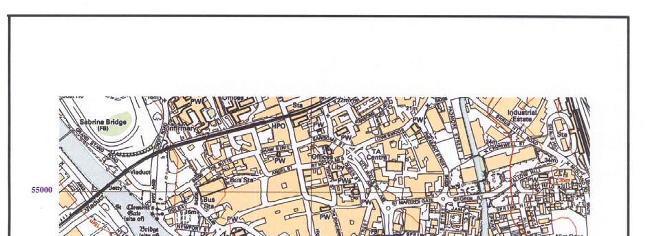
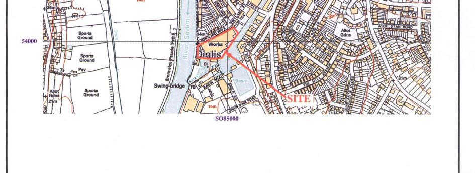
3 Portland Works, Royal Worcester Porcelain, Portland Walk, Diglis, Worcester An Archaeological Evaluation Introduction by Sean Wallis and Danielle Colls Report 04/65 This report documents the results of an archaeological field evaluation carried out at Portland Works, Royal Worcester Pottery, Portland Walk, Diglis, Worcester (SO ) (Fig. 1). The work was commissioned by Mr Andrew Saunders-Davies of Berkeley Homes (Oxford and Chiltern) Ltd, Berkeley House, Abingdon Science Park, Barton Lane, Abingdon, Oxfordshire, OX14 4NB. Planning permission (App no P05D0432) has been gained from Worcester City Council to redevelop the site of the Royal Worcester Porcelain works for a hotel complex and new residential apartments, with the refurbishment and reuse of other historic buildings. This permission applies to both the northern and southern parts of the Porcelain Works complex, and the planning consent is subject to three archaeological conditions (54, 55 and 56). Conservation Area consent has also been gained (App no L05D0073) with a further condition (2) for a record of the factory buildings and manufacturing processes prior to demolition. A summary of the relevant consents is presented in a brief for the project (WCM2006). The conditions attached are in accordance with the Department of the Environment s Planning Policy Guidance, Archaeology and Planning (PPG ), and the City Council s policies on archaeology. This report is wholly concerned with the field evaluation carried out in the southern part of the porcelain works known as Portland Works on Portland Walk. The development proposals for this area are for residential use and include basement car parking, for which a substantial reduced-level excavation will take place. The northern portion of the site (on Severn Street) has been subject to several stages of work already. Other reports will cover work in connection with the other conditions. The field investigation was carried out to a specification approved by Mr James Dinn, Archaeological Officer for Worcester City Council. The fieldwork was undertaken by Simon Cass, Jo Pine and Sean Wallis in May 2006, and the site code is RWP 04/65. The archive is presently held at Thames Valley Archaeological Services, Reading and will be deposited with Worcester Museum Service in due course. 1
4 Location, topography and geology The site is located in the Diglis area of Worcester, which is situated in the Severn Valley, to the north of the Severn s confluence with the River Teme. The site itself lies in the valley of a former tributary to the Severn, the Frog Brook, whose extant part now comprises part of the Birmingham to Worcester Canal. According to the British Geological Survey, the underlying geology consists of alluvium, with gravel terrace deposits of the River Severn occurring at the northern edge of the site (BGS 1993). A borehole investigation (STATS 2004) by showed that on average, made ground overlay alluvial deposits to a depth of at least 2m below present ground level. This majority of the excavated trenches, however, showed that the clays encountered at these depths were not naturally deposited. At the time of the evaluation, the site comprised an irregular parcel of land, the majority of which was occupied by a large industrial building. This was, until relatively recently, used by Royal Worcester Porcelain for the storage and finishing of various products. The site is reasonably flat and lies at a height of approximately 15m above Ordnance Datum. Archaeological background The archaeological background and potential of the site has been summarized in a brief for the project (WCM 2006) issued by Mr James Dinn, Archaeological Officer at Worcester City Museum, drawing on information presented in a desk-based assessment, small scale evaluation and watching brief during geotechnical investigation (AA 2005a; 2005b; 2005c; Morriss and Sherlock 2005). In summary, the site lies close to the confluence of the Frog Brook and River Severn (Fig. 1). Such a riparian location, especially if a terrace edge can be identified, is often one preferred for earlier prehistoric settlement and the Worcester City Historic Environment Record notes the presence of prehistoric metalwork finds recovered from the river nearby. There is also a possibility of the presence of Roman deposits on the site, perhaps associated with a river port. Roman deposits including burial are recorded both to the south of the site and immediately to the north at the Severn Street site (AA 2005b; 2005c). Also to the north, late Saxon and medieval deposits have been recorded. Prior to use as a factory, the site was used as allotments, a ropewalk, timber yard and saw mill and apparently as a dump of pottery manufacturing waste. 2
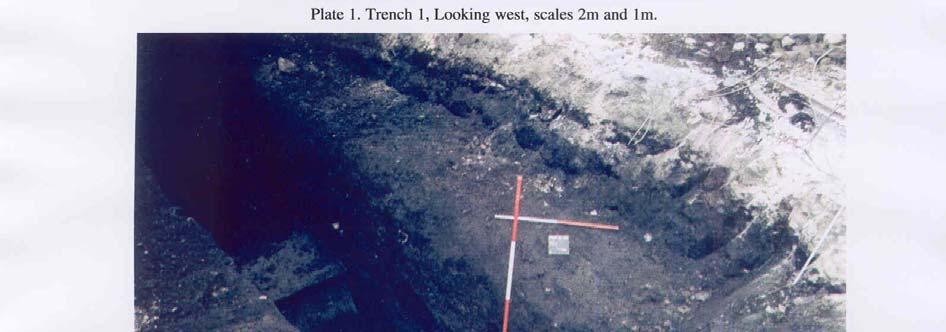
5 Objectives and methodology The purpose of the evaluation was to determine the presence/absence, extent, condition, character, quality and date of any archaeological deposits within the area of development. Specifically, these entail: to determine if archaeologically relevant levels have survived on this site; to determine if archaeological deposits of any period are present; to establish the depth of deposits above the natural geological outcrop; to determine if there are any deposits of prehistoric, Roman or later date. to determine if there are any deposits present relating to porcelain manufacturing. In the absence of archaeological deposits, palaeoenvironmental information was to be collected with regard to the nature and location of Frog Brook valley and stream, the confluence of the Brook and the River Severn, alluvial deposition and the presence of any palaeochannels of the River Severn. In order to fulfil these aims, it was determined that ten trenches, 23m long and 1.8m wide would be excavated by a 360º type mechanical excavator fitted with a toothless ditching bucket, under constant archaeological supervision. Due to the constraints imposed by the existing building, none of trenches could be excavated to their full length, and some had to be shifted slightly from their original intended positions. This was approved by the City Archaeological Officer after consultation on site. Borehole data from the periphery (outside) of the factory buildings (Stats 2004) indicated that the archaeologically relevant levels may be of the order of 1.5m 2m depth but increasing to 3m and down to 4.7m closer to the River. Therefore it was proposed that the trenches would not be excavated fully to a depth greater than 2.5m (assumed as the appropriate level for the basement foundation level). However, test pits were dug in each trench to examine a deeper profile of deposits on the site. A complete list of trenches giving lengths, breadths, depths and a description of sections and geology is given in Appendix 1. Results Ten trenches, all 1.8m wide, were excavated varying in length from 5.3m to 20.2m as shown on Figure 2. Several trenches were widened and stepped at the top to maintain stability. Trench 1 (Plate 1) Orientated east-west, This trench was 11.1m long and 2.5m deep. A test pit was dug at the east end of the trench to a depth of 3.4m. The stratigraphy in this trench comprised 0.15m of concrete over 0.15m of rubble hardcore. This in turn overlay 1.5m of made ground which sealed 0.20m of brown sandy silt, possibly a buried soil, which 3
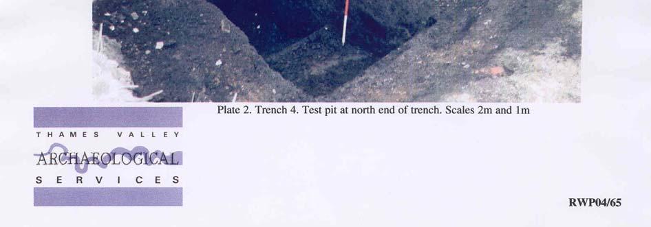
6 contained occasional fragments of ceramic building material and clinker. Directly below this was a thin band, 0.10m thick, of red/black ash, which overlay an orange/brown sandy clay which contained occasional fragments of brick (observed in section only). This deposit was recorded to a depth of 3.4m. The natural geology was not observed in this trench, and no archaeological finds or features were recorded. Trench 2 This trench measured 19.0m in length and was 3.0m deep overall. It was aligned west-east with a test pit 4.0m long and 3.50m deep at the western end of the trench. The overall stratigraphy was 0.25m of reinforced concrete floor surface overlaying 0.35m of rubble hardcore. This in turn overlay 2.90m of made ground, which comprised mottled dark brown/black sandy clay with frequent glass bottles and glass fragments, brick, pottery and clinker. A cut, filled with the made ground, was observed in the north-facing section of the test pit. This cut truncated a greenish grey silty clay deposit which contained moderate quantities of brick, pottery and coal (not retained). No archaeological finds or features were observed in this trench and natural geology was not encountered. Trench 3 This trench was aligned north west- south east and was 10.7m long and 2.6m deep. A test pit was excavated at the northern end of the trench to a depth of 3.5m. The upper stratigraphy of this trench was similar to the previous trenches with 0.25m of reinforced concrete over 0.35m of rubble hardcore which in turn overlay 1.7m of made ground/demolition rubble. This layer sealed a deposit of dark bluish grey silty clay, recorded to a depth of 3.5m, which contained occasional organic inclusions though it is uncertain if this is alluvium or a further episode of made ground. Concrete foundations with steel girders were observed along the eastern edge of the trench and may be foundations for the current building or perhaps a slightly earlier structure. A cut was also observed at the southern end of the trench, similar to the cut observed in Trench 2. Trench 4 (Plate 2) This trench was 5.3m long and 2.50m deep overall, and was aligned north east- south west. The stratigraphy consisted of 0.25m of reinforced concrete floor surface, overlying 0.35m of rubble hardcore, which in turn overlay 1.80m of made ground, comprising 19th- and 20th-century detritus, large amounts of pottery, glass and ash (not retained). In the test pit at the north end of the trench a second deposit of made ground was observed from 2.50m to a depth of 3.60m at the base of the test pit. This comprised dark blue grey silty clay and, as in 4
7 other trenches, contained fragments of brick, pottery and coal (which were not retained). No finds or deposits of archaeological interest were observed and the natural geology was not observed. Trench 5 (Plate 3) This trench was 10.0m long and 2.5m deep overall, and was aligned east-west The stratigraphy showed 0.25m of reinforced concrete floor surface overlaying 0.35m of rubble hardcore. This in turn overlay layers of made ground 1.50m thick, mainly comprising 19th- and 20th-century domestic waste, glass and china fragments. This overlay a deposit of dark blue grey silty clay with brick and transfer-printed china fragments, which the test pit at the east end exposed to a depth of 3.50m. No finds or deposits of archaeological interest were observed. Trench 6 This trench was aligned south west- north east and was 20.2m in length and 2.6m deep. It was excavated to 3.6m in a test pit at the south-west end. The stratigraphy comprised 0.30m concrete overlying 0.35m of rubble hardcore make up over 2.25m of made ground containing 19th- and 20th-century bottles and jars. This layer of made ground sealed a dark blue grey silty clay, observed in the test pit only, which contained occasional fragments of 19th- and 20th-century china. Close to the north-east end of the trench, the blue clay was truncated by dumps of made ground which contained occasional fragments of china and coal; this again appears similar to the cuts observed in Trenches 1 and 3. Natural geology was not recorded in this trench and no finds or features of archaeological significance were observed. Trench 7 (Plate 4) This trench was aligned South west- north east and was 14.10m in length and 2.7m deep overall, with a test pit at 4m from the south-west end taken to a depth of 3.50m (Fig. 4). A brick-built drain caused the trench to be stepped up from 8.5m to 11m. The stratigraphy showed 0.25m of reinforced concrete floor surface overlaying 0.35m of rubble hardcore. This in turn overlay made ground, comprising distinct bands of demolition rubble with only occasional glass and pottery fragments, observed to a depth of 3.50m. No finds or deposits of archaeological interest were observed Trench 8 Aligned south west- north east, this trench measured 10.1m in length and 2.7m deep, with a test pit excavated at the north-east end to a depth of 3.70m. The stratigraphy comprised 0.30m of concrete over 0.30m of rubble 5
8 hardcore. This overlay a made ground deposit, 1.5m thick, which sealed a dark grey silty clay deposit, recorded to a depth of 3.70m, which contained fragments of brick and architectural stone. In the north-east facing section of the test pit a clean reddish brown sand and gravel was observed. This deposit is thought to be redeposited natural geology as the dark grey silty clay appears to be tipped against it as opposed to overlying it. No archaeological finds or features of interest were observed and the natural geology was not observed in this trench. Trench 9 This trench was aligned north east- south west, 7.1m long and 2.6m deep. A test pit was dug at the south end to a depth of 3.4m. The stratigraphy was generally similar to the other trenches with concrete, 0.25m thick, overlying 0.35m of rubble hardcore which in turn overlay 1m of made ground. Below the made ground a dark bluish grey clay was recorded, 0.90m thick, containing ash and brick fragments (but no domestic waste this time) and this deposit sealed a dark grey brown sandy clay and gravel which also occasional brick fragments, chain and coal. In the test pit this layer was observed to be approximately 0.40m deep and overlay a brown/grey silty clay with very occasional brick fragments. No archaeological finds or features of interest were recorded and the natural geology was not observed in this trench. Trench 10 The final trench was 6.3m in length, 1.6m deep and orientated SE NW. This trench proved difficult to excavate due to lack of space and its close proximity to the main access road. Concrete footings were observed truncating the entire south-east edge of the trench; these are most likely associated with a basement. Where the trench was not truncated the stratigraphic sequence observed was 0.20m of Tarmac and concrete, overlying 0.20m of rubble hardcore. This overlay 0.70m of made ground which in turn sealed a reddish/brown sandy clay, 0.50m thick, containing 19th- and 20th-century pottery. The excavation of this trench was stopped at this depth as it was impossible to continue without the complete removal of concrete footings. No archaeological deposits or finds were observed and the natural geology was not observed. 6
9 Finds Fragments of ceramic building material, pottery and glass recovered from the trenches were readily identified on site as consistently of 19th- and 20th-century dates; a small representative sample has been retained temporarily but will be discarded. Conclusion The site is located on land that appears to have been built up and levelled extensively, possibly during the 18th century and certainly during the 19th and 20th centuries. This is consistent with known patterns of land use on this site, and the development of the local waterway system from the 1790s onwards. The combination of domestic and industrial waste and fine silts and clays encountered throughout the deposits on the site supports the evidence for levelling given by the borehole survey. Considerable quantities of silts and clays may have been imported from the Frog Brook or the associated stretch of the Birmingham to Worcester canal after phases of dredging or cleaning, and used to level the site. None of these deposits represents a former course of the Frog Brook or the Severn and none is a naturally laid alluvium. If any archaeological deposits survive on this site from the medieval period or earlier, they will lie beneath the relatively recent deposits encountered in this evaluation. As such the foundations of any development proposals which are largely or wholly located with these modern deposits, such as the basement proposed for the specific development project which instigated this evaluation, will have little or no impact on any buried archaeological deposits even if present. References AA, 2005a, Portland Walk, Worcester, an archaeological desk-based assessment, Archenfield Archaeology, WCM , Fownhope AA, 2005b, The archaeological evaluation of Royal Worcester Porcelain, Severn Street, Worcester; Stage 1, Archenfield Archaeology, WCM , Fownhope AA, 2005c, The archaeological evaluation of Royal Worcester Porcelain, Severn Street, Worcester; Stage 2, Archenfield Archaeology, WCM , Fownhope BGS, 1971, British Geological Survey, 1:50000, Sheet 199, Solid and Drift Edition, Keyworth Morriss, R K and Sherlock H, 2005, Re-development of surplus land at the Royal Worcester Porcelain Factory, Worcester, The archaeology of the Portland Walk and Severn Street sites, Archenfield Archaeology PPG16, 1990, Archaeology and Planning, Dept of the Environment Planning Policy Guidance 16, HMSO STATS, 2004, Royal Worcester Site, Severn Street and Portland Walk, Worcester, Geotechnical and Geoenvironmental Report, STATS Ltd, report 34281/02, St Albans WCM 2006, Brief for archaeological mitigation (including evaluation), Royal Worcester Porcelain site, Portland Walk, Worcester, Worcester City Museum Archaeology Section Brief 06/5 7
10 APPENDIX 1: Trench details 0m at S or W end Trench No. Length (m) Breadth (m) Depth (m) Comment test pit m Reinforced concrete, m Rubble hardcore; m made ground; m mid brown sandy silt with occasional brick fragments and clinker; m thin layer of red/black ash; m mid orange browns sandy clay with very occasional ceramic building material. No archaeological finds or features observed. Natural geology not observed. [Plate 1] test pit test pit test pit test pit test pit test pit test pit test pit m Reinforced concrete; m Rubble hardcore; m dark brown black sandy clay containing domestic debris (bottles, china, brick fragments). In test pit: m greenish grey silty clay with small brick and pottery fragments and coal. No archaeological finds or features observed. Natural geology not observed m Reinforced concrete; m Rubble hardcore; m made ground; m dark bluish grey silty clay. No archaeological finds or features were observed. Natural geology not observed m Reinforced concrete, m Rubble hardcore, m made ground containing domestic debris, m dark blue grey silty clay with occasional coal, pottery and brick fragments. [Plate 2] m Reinforced concrete, m Rubble hardcore, m made ground, m dark blue grey silty clay with moderate brick and china fragments. No archaeological finds or features observed. Natural geology not observed. [Plate 3] m Reinforced concrete, m Rubble hardcore, m made ground containing domestic debris, m dark blue grey silty clay with rare china fragments and coal. At 16.8m from south-west end, where the clay was reached at only 2.3m down, the made ground appeared to truncate the clay. No archaeological finds or features observed. Natural geology not observed m Reinforced concrete, m Rubble hardcore, m bands of made ground comprising largely demolition rubble. No archaeological finds or features observed. Natural geology not observed. [Plate 4] m Reinforced concrete; 0/ m rubble hardcore; m made ground; m dark grey silty clay with brick fragments. No archaeological deposits or features observed. Natural geology not observed m Reinforced concrete; m Rubble hardcore; made ground; m Dark bluish grey clay with occasional ash and brick fragments; Dark grey brown sandy clay with occasional brick fragments; m mid brownish grey silty clay with very occasional brick fragments m Reinforced; m rubble hardcore; m made ground; m mid reddish brown sandy. No archaeological features or finds. Natural geology not observed. 8


11
12
13
14
15

16
Portland Works, Royal Worcester Porcelain, Portland Walk, Diglis, Worcester
 Portland Works, Royal Worcester Porcelain, Portland Walk, Diglis, Worcester An Archaeological Watching Brief For Berkeley Homes (Oxford and Chiltern) Limited by Danielle Milbank Thames Valley Archaeological
Oxford Bus Company Depot, Cowley Road, Oxford
 Oxford Bus Company Depot, Cowley Road, Oxford An Archaeological Evaluation (Stage 2) for Berkeley Homes (Oxford and Chiltern) Ltd by Jo Pine Thames Valley Archaeological Services Ltd Site Code GAG 00/32
Charlmont Road, Tooting, London Borough of Wandsworth
 123-125 Charlmont Road, Tooting, London Borough of Wandsworth An Archaeological Evaluation For Eramo Developments Limited by Andrew Weale and Andrew Taylor Thames Valley Archaeological Services Ltd Site
Land adjacent to 103 Pound Lane, Sonning, Berkshire
 Land adjacent to 103 Pound Lane, Sonning, Berkshire An Archaeological Evaluation for Hicks Development Ltd by James McNicoll-Norbury Thames Valley Archaeological Services Ltd Site Code PLS 09/50 June 2009
ARCHAEOLOGICAL S E R V I C E S. 1 Beechmount Road, Southampton, Hampshire. Archaeological Watching Brief. by David Platt. Site Code: SOU1649
 T H A M E S V A L L E Y ARCHAEOLOGICAL S E R V I C E S 1 Beechmount Road, Southampton, Hampshire Archaeological Watching Brief by David Platt Site Code: SOU1649 (SU 4188 1616) 1 Beechmount Road, Southampton,
Summers Place, Stane Street, Billingshurst, West Sussex
 Summers Place, Stane Street, Billingshurst, West Sussex An Archaeological Evaluation for Berkeley Homes (Southern) Ltd by Simon Cass Thames Valley Archaeological Services Ltd Site Code SPB 07/33 March
Land at Larchwood Farm, Whitehorse Lane Finchampstead, Berkshire
 Land at Larchwood Farm, Whitehorse Lane Finchampstead, Berkshire An Archaeological Evaluation for Mr. John Westbrook by James McNicoll-Norbury Thames Valley Archaeological Services Ltd Site Code LFF08/103
ARCHAEOLOGICAL S E R V I C E S. 6a Old Mill Way, Shirley, Southampton, Hampshire. Archaeological Evaluation. by Daniel Bray. Site Code: SOU 1640
 T H A M E S V A L L E Y ARCHAEOLOGICAL S E R V I C E S 6a Old Mill Way, Shirley, Southampton, Hampshire Archaeological Evaluation by Daniel Bray Site Code: SOU 1640 (SU 3934 1442) 6a Old Mill Way, Shirley,
Former transport depot, Charlton Road, Charlton, Shepperton, Surrey
 Former transport depot, Charlton Road, Charlton, Shepperton, Surrey An Archaeological Evaluation for St James Homes Ltd by Steve Ford Thames Valley Archaeological Services Ltd Site Code CRC06/117 June
25 Whiteknights Road, Reading, Berkshire
 25 Whiteknights Road, Reading, Berkshire An Archaeological Evaluation for B & M Care by Sean Wallis Thames Valley Archaeological Services Ltd Site Code WRR07/74 July 2007 Summary Site name: 25 Whiteknights
Former Cart Shed, Stroud Farm, Holyport, Maidenhead, Berkshire
 Former Cart Shed, Stroud Farm, Holyport, Maidenhead, Berkshire An Archaeological Watching Brief For Mr Simon Rinder by Stephen Hammond and Jennifer Lowe Thames Valley Archaeological Services Ltd Site Code
Land at Model Farm Cottages, Bath Road, Sonning, Berkshire
 Land at Model Farm Cottages, Bath Road, Sonning, Berkshire An Archaeological Evaluation for The Keen Partnership by Andy Taylor Thames Valley Archaeological Services Ltd Site Code BRS 04/55 June 2004 Summary
Land off Luton Road, Farley Hill, Luton, Bedfordshire
 Land off Luton Road, Farley Hill, Luton, Bedfordshire An Archaeological Evaluation for 3Sixty Construction Ltd by Andrew Mundin Thames Valley Archaeological Services Ltd Site Code LRL 08/82 August 2008
Acrefield Cottage, Winkfield Street, Maidens Green, Winkfield, Windsor, Berkshire
 Acrefield Cottage, Winkfield Street, Maidens Green, Winkfield, Windsor, Berkshire An Archaeological Watching Brief For Mr and Mrs Elia by Pamela Jenkins Thames Valley Archaeological Services Ltd Site Code
Diddenham Court, Grazeley, Reading, Berkshire, Phase 2
 Diddenham Court, Grazeley, Reading, Berkshire, Phase 2 An Archaeological Watching Brief For Fenchurch Estates (Diddenham) Ltd by Steve Hammond and Simon Cass Thames Valley Archaeological Services Ltd Site
The Rising Sun, Guildford Road, Fetcham, Surrey
 The Rising Sun, Guildford Road, Fetcham, Surrey An Archaeological Evaluation for Bovis Homes Limited by Steve Ford Thames Valley Archaeological Services Ltd Site Code RGF04/80 March 2005 Summary Site name:
Bramley Grange, Horsham Road, Bramley, Surrey
 Bramley Grange, Horsham Road, Bramley, Surrey An Archaeological Evaluation for English Villages Housing Association by Stephen Hammond Thames Valley Archaeological Services Ltd Site Code BGB 03/95 October
Oxford Options Resource Centre, Horspath Driftway, Headington, Oxford
 Oxford Options Resource Centre, Horspath Driftway, Headington, Oxford An Archaeological Watching Brief For Oxfordshire County Council by Tim Dawson and Heather Hopkins Thames Valley Archaeological Services
Culham Court, Aston, Remenham, Berkshire
 Culham Court, Aston, Remenham, Berkshire An Archaeological Evaluation for Woody Clark Limited by Sean Wallis Thames Valley Archaeological Services Ltd Site Code CCA 07/117 October 2007 Summary Site name:
30 Broad Street, Wokingham, Berkshire
 30 Broad Street, Wokingham, Berkshire An Archaeological Watching Brief for Psilogic Ltd by Steve Ford Thames Valley Archaeological Services Ltd Site Code 30BSW01/81 October 2001 Summary Site name: 30 Broad
ARCHAEOLOGICAL S E R V I C E S. Kingsley Academy, Prince Regent Road, Hounslow, London Borough of Hounslow. Archaeological Evaluation
 T H A M E S V A L L E Y ARCHAEOLOGICAL S E R V I C E S Kingsley Academy, Prince Regent Road, Hounslow, London Borough of Hounslow Archaeological Evaluation by James McNicoll-Norbury Site Code: CCL15/173
Roman Farm, Nettleden, Hemel Hempstead, Hertfordshire
 Roman Farm, Nettleden, Hemel Hempstead, Hertfordshire An Archaeological Watching Brief for Mercantile Land Development Ltd by Siân Anthony Thames Valley Archaeological Services Ltd Site Code RFN01/82 October
Thames Valley University, Kings Road, Reading, Berkshire
 Thames Valley University, Kings Road, Reading, Berkshire An Archaeological Evaluation for Thames Valley University by Danielle Milbank and Steve Ford Thames Valley Archaeological Services Ltd Site Code
181 London Road, Isleworth, London Borough of Hounslow
 181 London Road, Isleworth, London Borough of Hounslow An Archaeological Evaluation for Crest Nicholson Residential (South) Ltd by Jo Pine and Andy Taylor Thames Valley Archaeological Services Ltd Site
New Sunday School, St Mary s Church, White Waltham, Maidenhead, Berkshire
 New Sunday School, St Mary s Church, White Waltham, Maidenhead, Berkshire An Archaeological Evaluation for White Waltham and Shottesbrook Parochial Church Council by Simon Cass Thames Valley Archaeological
T H A M E S V A L L E Y S E R V I C E S. Land between 138 and 142 Southcote Lane, Reading, Berkshire. Archaeological Evaluation
 T H A M E S V A L L E Y ARCHAEOLOGICAL S E R V I C E S Land between 138 and 142 Southcote Lane, Reading, Berkshire Archaeological Evaluation by James McNicoll-Norbury Site Code: SLR09/121 (SU 6935 7215)
Pumping Station, Whytelaydes Lane, Cookham Rise, Berkshire
 Pumping Station, Whytelaydes Lane, Cookham Rise, Berkshire An Archaeological Evaluation for Gullett and Sons Ltd by Simon Cass Thames Valley Archaeological Services Ltd Site Code WLC 07/156 November 2007
Shotover View, Craufurd Road, Oxford
 Shotover View, Craufurd Road, Oxford An Archaeological Evaluation for Oxfordshire County Council by James Lewis Thames Valley Archaeological Services Ltd Site Code: CRO07/169 July 2008 Summary Site name:
Former PLA Recreation Ground, The Drive, Ilford, London Borough of Redbridge
 Former PLA Recreation Ground, The Drive, Ilford, London Borough of Redbridge An Archaeological Evaluation for CgMs Ltd by Steve Ford Thames Valley Archaeological Services Ltd Site Code FPL06 May 2006 Summary
S E R V I C E S. The Vicarage, Victoria Square, Lee-on-the-Solent, Hampshire. Archaeological Watching Brief. by Ellen McManus-Fry. Site Code: VVL16/97
 T H A M E S V A L L E Y ARCHAEOLOGICAL S E R V I C E S The Vicarage, Victoria Square, Lee-on-the-Solent, Hampshire Archaeological Watching Brief by Ellen McManus-Fry Site Code: VVL16/97 (SU 5618 0093)
Redgrave Pinsent Rowing Lake, Caversham Lakes, Henley Road, Caversham, Oxfordshire
 Redgrave Pinsent Rowing Lake, Caversham Lakes, Henley Road, Caversham, Oxfordshire An Archaeological Evaluation: Phase 2 for Mott McDonald Ltd by Sarah Coles and Sian Anthony Thames Valley Archaeological
Bedwell Park, Essendon, Hatfield, Hertfordshire
 Bedwell Park, Essendon, Hatfield, Hertfordshire An Archaeological Evaluation for Millgate Homes By Andy Taylor Thames Valley Archaeological Services Ltd Site Code BPE 06/34 November 2006 Summary Site name:
Wheldon View, Wheldon Road, Castleford West Yorkshire
 Wheldon View, Wheldon Road, Castleford West Yorkshire An Archaeological Evaluation for Exemplar plc by Sarah Coles Thames Valley Archaeological Services Ltd Site Code WWC03/23 March 2003 Summary Site name:
S E R V I C E S. Long Acre, 228 Greys Road, Henley-on-Thames, Oxfordshire. Archaeological Watching Brief. by Andy Taylor. Site Code: GRH12/185
 T H A M E S V A L L E Y ARCHAEOLOGICAL S E R V I C E S Long Acre, 228 Greys Road, Henley-on-Thames, Oxfordshire Archaeological Watching Brief by Andy Taylor Site Code: GRH12/185 (SU 7443 8162) Long Acre,
Whitelands College, West Hill, Putney, London Borough of Wandsworth
 Whitelands College, West Hill, Putney, London Borough of Wandsworth An Archaeological Evaluation for Crest Nicholson Residential (South) Ltd by Sian Anthony Thames Valley Archaeological Services Ltd Site
T H A M E S V A L L E Y S E R V I C E S. Sidcup World of Golf, Sidcup Road, London Borough of Bromley. An Archaeological Evaluation.
 T H A M E S V A L L E Y ARCHAEOLOGICAL S E R V I C E S Sidcup World of Golf, Sidcup Road, London Borough of Bromley An Archaeological Evaluation by James Lewis Site Code: SDP09 (TQ 4450 7212) Sidcup World
10-12 Fishbourne Road East, Chichester, West Sussex
 0-2 Fishbourne Road East, Chichester, West Sussex An Archaeological Evaluation for Croudace Homes Limited by Andy Taylor Thames Valley Archaeological Services Ltd Site Code FRC 07/05 January 2007 Summary
T H A M E S V A L L E Y S E R V I C E S. Essex Wharf, Lea Bridge Road, Clapton, London Borough of Waltham Forest. An Archaeological Evaluation
 T H A M E S V A L L E Y ARCHAEOLOGICAL S E R V I C E S Essex Wharf, Lea Bridge Road, Clapton, London Borough of Waltham Forest An Archaeological Evaluation by Andy Weale Site Code: EXW08 (TQ 3553 8667)
ARCHAEOLOGICAL S E R V I C E S. Land at Mathisen Way, Poyle, Berkshire. Archaeological Evaluation. by Andy Taylor. Site Code: MWP17/271 (TQ )
") T H A M E S V A L L E Y ARCHAEOLOGICAL S E R V I C E S Land at Mathisen Way, Poyle, Berkshire Archaeological Evaluation by Andy Taylor Site Code: MWP17/271 (TQ 0345 7640) Land at Mathisen Way, Poyle, Berkshire
T H A M E S V A L L E Y ARCHAEOLOGICAL S E R V I C E S Land at Mathisen Way, Poyle, Berkshire Archaeological Evaluation by Andy Taylor Site Code: MWP17/271 (TQ 0345 7640) Land at Mathisen Way, Poyle, Berkshire
10 12 Fishbourne Road East, Chichester, West Sussex
 0 Fishbourne Road East, Chichester, West Sussex An Archaeological Watching Brief For Croudace Homes Ltd by Andrew Mundin Thames Valley Archaeological Services Ltd Site Code FRC 07/05 September 007 Summary
Old Walls, Sonning Lane, Sonning, Berkshire
 Old Walls, Sonning Lane, Sonning, Berkshire An Archaeological Evaluation for Mr Tony Griffiths by Andy Taylor Thames Valley Archaeological Services Ltd Site Code WSS 06/36 April 2006 Summary Site name:
ARCHAEOLOGICAL S E R V I C E S. New wet dock, Longview, Bisham Road, Bisham, Berkshire. Archaeological Watching Brief.
 T H A M E S V A L L E Y ARCHAEOLOGICAL S E R V I C E S New wet dock, Longview, Bisham Road, Bisham, Berkshire Archaeological Watching Brief by Daniel Bray Site Code: LDB15/131 (SU 8493 8589) New wet dock,
Graven Hill to Ambrosden Replacement Water Pipeline and Tank, Bicester, Oxfordshire
 Graven Hill to Ambrosden Replacement Water Pipeline and Tank, Bicester, Oxfordshire An Archaeological Watching Brief For Trant Construction Ltd by Stephen Hammond and Pamela Jenkins Thames Valley Archaeological
S E R V I C E S. Chadwell Heath Golf Club, Romford, London Borough of Havering. Archaeological Evaluation Phase 2. by Susan Porter.
 T H A M E S V A L L E Y ARCHAEOLOGICAL S E R V I C E S Chadwell Heath Golf Club, Romford, London Borough of Havering Archaeological Evaluation Phase 2 by Susan Porter Site Code: WLB09 (TQ 4875 8875) Chadwell
ARCHAEOLOGICAL S E R V I C E S. Elizabeth House, West Street, Newbury, West Berkshire. Archaeological Evaluation. by David Platt. Site Code: EHN12/167
 T H A M E S V A L L E Y ARCHAEOLOGICAL S E R V I C E S Elizabeth House, West Street, Newbury, West Berkshire Archaeological Evaluation by David Platt Site Code: EHN12/167 (SU 4694 6738) Elizabeth House,
Western House School, Brook Path, Cippenham, Slough, Berkshire
 Western House School, Brook Path, Cippenham, Slough, Berkshire An Archaeological Evaluation for George Wimpey West London Ltd by James Lewis Thames Valley Archaeological Services Ltd Site Code WCS 07/46
S E R V I C E S S O U T H
 T H A M E S V A L L E Y ARCHAEOLOGICAL S E R V I C E S S O U T H The orthbrook Site, West Durrington, Worthing, West Sussex Area B Archaeological Evaluation by Sean Wallis Site Code: CW11/113 (TQ 1070
Smallford Campus, Oaklands College, St Albans, Hertfordshire
 Smallford Campus, Oaklands College, St Albans, Hertfordshire An Archaeological Evaluation for Taylor Wimpey by Andrew Weale and Danielle Milbank Thames Valley Archaeological Services Ltd Site Code OCH04/82a
ARCHAEOLOGICAL S E R V I C E S. Land adjacent to Church Farm, West Hanney, Oxfordshire. Archaeological Evaluation. by Andrew Mundin and Lizzi Lewins
 T H A M E S V A L L E Y ARCHAEOLOGICAL S E R V I C E S Land adjacent to Church Farm, West Hanney, Oxfordshire Archaeological Evaluation by Andrew Mundin and Lizzi Lewins Site Code: CFO16/147 (SU 4076 9283)
Archaeological Evaluation of Land off Hubbards Lane, Boughton Monchelsea, Kent
 Archaeological Evaluation of Land off Hubbards Lane, Boughton Monchelsea, Kent NGR: 576190 151300 Site Code: HUB/EV/16 (Planning Application: 16/500014/OUT/MA) SWAT Archaeology The Office, School Farm
Monitoring Report No. 022 GREENCASTLE BURIALS GREEN CASTLE COUNTY DOWN LICENCE NO. N/A PHILIP MACDONALD
 Monitoring Report No. 022 GREENCASTLE BURIALS GREEN CASTLE COUNTY DOWN LICENCE NO. N/A PHILIP MACDONALD Monitoring Report No. 022 Greencastle Burials (SMR No. Down 057:017) Greencastle Co. Down Philip
Dawley Park, Kestrel Way, Hayes, London Borough of Hillingdon
 Dawley Park, Kestrel Way, Hayes, London Borough of Hillingdon An Archaeological Evaluation for Black Country Properties Limited by Steve Ford Thames Valley Archaeological Services Ltd Site Code DWP01 May
Archaeological Monitoring and Recording
 Brampton Primary School Archaeological Monitoring and Recording Report August 2014 Client: Cambridgeshire County Council OA East Report No: 1648 OASIS No: oxfordar3-187917 NGR: TL 52055 27081 Archaeological
Evaluation/Monitoring Report No. 152
 Evaluation/Monitoring Report No. 152 150m west of 7 Portmore Rd. Portmore Lower Ballinderry County Antrim LICENCE NO.: AE/07/241 David McIlreavy 1 Site Specific Information Site Name Townland County :
Evaluation/Monitoring Report No. 259
 SITE 100M EAST OF 16 LEARMORE ROAD CASTLEGORE CASTLEDERG COUNTY TYRONE LICENCE NO.: AE/13/36E NAOMI CARVER 1 Site Specific Information Site Name: 100m east of 16 Learmore Road, Castlederg, Co. Tyrone Townland:
o a West Midlands Wednesbury Woden Road Former Sandwell College Archaeological Evaluation Report Oxford Archaeology
 Former Sandwell College Woden Road Wednesbury West Midlands o a Oxford Archaeology November 2004 Client: John Samuels Archaeological Consultants Issue N o : 1 OA Job N o : 2435 Planning Ref N o : DC/04/42731
Diglis Basin Worcester
 Diglis Basin Worcester o a December 2005 client logo Client: CgMs Consulting Issue N o : 1 OA Job N o : 2670 NGR:SO 8500 5380 Client Name: CgMs Consulting Client Ref No: - Document Title: Diglis Basin,
ARCHAEOLOGICAL S E R V I C E S. Eton College Sports Pavilion, Slough Road, Eton, Berkshire. Archaeological Evaluation.
 T H A M E S V A L L E Y ARCHAEOLOGICAL S E R V I C E S Eton College Sports Pavilion, Slough Road, Eton, Berkshire Archaeological Evaluation by Andy Taylor Site Code: SRE17/51 (SU 9699 7874) Eton College
Archaeological Watching Brief
 Polar Technology, Eynsham Geotechnical Test Pits Archaeological Watching Brief Report February 2017 Client: Polar Technology Management Group Issue No: 1 OA Job No: 6601 NGR: SP 42762 08827 Archaeological
Archaeological Monitoring of Land at Seacrest, Cliff Drive, Warden, Isle of Sheppey, Kent
 Archaeological Monitoring of Land at Seacrest, Cliff Drive, Warden, Isle of Sheppey, Kent Site Code SEA/WB/15 Report for Kevin & Lesley O Brian Date of report 14/10/2015 SWAT ARCHAEOLOGY Swale and Thames
Chadwell Heath Golf Club, Romford, London Borough of Havering
 Chadwell Heath Golf Club, Romford, London Borough of Havering An Archaeological Evaluation (Phase 1) for Cranfield Golf Academy By Andrew Weale Thames Valley Archaeological Services Ltd Site Code WBL 09
Figures Figure 1. Location Plan...4 Figure 2. Location of long wing and short wing of the development...8
 Contents Page Summary...2 Acknowledgements...2 Copyright notice...2 1 Introduction...3 1.1 Project background and commission...3 1.2 Location, topography and geology...3 1.3 Historical and archaeological
Gransmoor Quarry, Gransmoor, East Riding of Yorkshire
 Gransmoor Quarry, Gransmoor, East Riding of Yorkshire An Archaeological Evaluation for W. Clifford Watts Ltd. by Andrew Weale Thames Valley Archaeological Services Ltd Site Code GQY07/32 March 2007 Summary
T H A M E S V A L L E Y S E R V I C E S. Camel Hill Farm, Queen Camel, Sparkford, Somerset. Archaeological Evaluation.
 T H A M E S V A L L E Y ARCHAEOLOGICAL S E R V I C E S Camel Hill Farm, Queen Camel, Sparkford, Somerset Archaeological Evaluation by Andrew Weale Site Code: CHS10/106 (ST 5816 2559) Camel Hill Farm, Queen
Todmorden Wind Farm Geotechnical Site Investigations, Calderdale, West Yorkshire
 Todmorden Wind Farm Geotechnical Site Investigations, Calderdale, West Yorkshire Archaeological Watching Brief Report Oxford Archaeology North March 2013 I and H Brown Issue No: 2012-13/1370 OA North Job
Archaeological Evaluation and Assessment of Land at Roselands, Sedlescombe, East Sussex
 Archaeological Evaluation and Assessment of Land at Roselands, Sedlescombe, East Sussex NGR: TQ 78013 18096 Site Code: ROSE/EV/16 (Planning Application: RR/2015/2248/P) SWAT Archaeology The Office, School
LONG PRESTON DEEPS, RIBBLESDALE, NORTH YORKSHIRE
 LONG PRESTON DEEPS, RIBBLESDALE, NORTH YORKSHIRE Archaeological Watching Brief Oxford Archaeology North October 2011 ENVIRONMENT AGENCY Issue No: 2011 12/1231 OA North Job No: L10410 NGR: SD 8110 6090
Archaeology of East Oxford Project: Minchery Paddock 2012 Trench 1 Excavation Narrative report
 Archaeology of East Oxford Project: Minchery Paddock 2012 Trench 1 Excavation Narrative report Julian Stern and Olaf Bayer Introduction & Summary Trench 1 was the northern most of three trenches excavated
DIDSBURY FLOOD STORAGE BASIN, GREATER MANCHESTER
 DIDSBURY FLOOD STORAGE BASIN, GREATER MANCHESTER Archaeological Watching Brief Report Oxford Archaeology North August 2009 Environment Agency Issue No: 2009-10/971 OA North Job No: L10130 NGR: SJ 8415
Long Ashes Holiday Park Threshfield North Yorkshire
 on behalf of GVA Humberts Leisure for Lakeland Leisure Estates Ltd Long Ashes Holiday Park Threshfield North Yorkshire archaeological evaluation report 3027 December 2012 Contents 1. Summary 1 2. Project
Geophysical Survey Report
 Report Lost Mansion of Nydfwch, Penllergare, Swansea for January 2008 J2449 John Cook BSc. (Hons) Document Title: Client: Stratascan Job No: Techniques: Report Lost Mansion of Nydfwch, Penllergare, Swansea
Oxford. Somerville College. Wolfson Building Extension. Archaeological Evaluation Report. Client: AKS Ward. September 2011
 Wolfson Building Extension Somerville College Oxford Archaeological Evaluation Report September 2011 Client: AKS Ward Issue No: 1 OA Job No: 5152 NGR: Centred at 5091 0692 Archaeological Evaluation Report
Collfryn Ring-ditch, Guilsfield, Powys
 CPAT Report No 1122 TRIAL EXCAVATION 2011 THE CLWYD-POWYS ARCHAEOLOGICAL TRUST CPAT Report No 1122 TRIAL EXCAVATION 2011 I Grant December 2011 Report for Cadw The Clwyd-Powys Archaeological Trust 41 Broad
Hyde Parish Hall, Hyde Street, Winchester, Hampshire
 Hyde Parish Hall, Hyde Street, Winchester, Hampshire An Archaeological Evaluation for Hyde Parish Council by Stephen Hammond Thames Valley Archaeological Services Ltd Site Code AY 135 April 2003 Summary
St Antony s College. Oxford. Archaeological Evaluation Report. o a. September Client: St Antony's College
 St Antony s College Oxford Archaeological Evaluation Report o a September 2008 Client: St Antony's College Issue No:1 OA Job No: 4131 NGR: SP 509 074 Archaeological Evaluation Report Client Name: St Antony's
Northamptonshire Archaeology
 Northamptonshire Archaeology Archaeological Geophysical Survey At Sulgrave Castle Green, Sulgrave, Northamptonshire August 2007 Adrian Butler November 2007 Report 07/192 Northamptonshire Archaeology 2
400 Longwater Avenue, Green Park, Reading Archaeological Evaluation Report. Client: Mapletree Investments. August 2018
 400 Longwater Avenue, Green Park, Reading Archaeological Evaluation Report August 2018 Client: Mapletree Investments Issue No: 1 OA Reference No: 7102 NGR: SU 69872 69869 Oxford Archaeology Ltd 15 August
C261 ARCHAEOLOGY EARLY EAST Interim Statement Archaeological Watching Briefs and Evaluation C123 Limmo Peninsula Shaft - XRW10
 C261 ARCHAEOLOGY EARLY EAST Interim Statement Archaeological Watching Briefs and Evaluation C123 Limmo Peninsula Shaft - XRW10 Document Number: Document History: Revision: Date: Prepared by: Checked by:
patersongroup Mineral Aggregate Assessment 3119 Carp Road Ottawa, Ontario Prepared For Mr. Greg LeBlanc March 7, 2014 Report: PH2223-REP.
 Geotechnical Engineering Environmental Engineering group Hydrogeology Geological Engineering Archaeological Studies Materials Testing 3119 Carp Road Prepared For Mr. Greg LeBlanc March 7, 2014 Paterson
Archaeological Evaluation at Howt Green Farm, Sheppey Way, Bobbing, Kent
 Archaeological Evaluation at Howt Green Farm, Sheppey Way, Bobbing, Kent NGR: 589575 166122: Site Code: HGF-EV-14 (Planning Reference: SW/13/0501) Date of Report: 11/04/14 Amended 07/05/2014 SWAT Archaeology
Garratt Lane, Wandsworth, London Borough of Wandsworth
 140-150 Garratt Lane, Wandsworth, London Borough of Wandsworth An Archaeological Desk-Based Assessment for St James Homes by Jennifer Lowe Thames Valley Archaeological Services Ltd Site Code GLW 03/59
Archaeological Monitoring Report
 Archaeological Monitoring Report High Lodge, Santon Downham SMR Nos. STN 067, STN 068 A REPORT ON THE ARCHAEOLOGCAL MONTORNG, 2002 Andrew Tester Field Team Suffolk C.C. Archaeological Service November
Geophysical Survey. Ballymount Co. Dublin. Licence Ref. 02R029. By John Nicholls Margaret Gowen & Co. Ltd. For LRT
 Geophysical Survey Ballymount Co. Dublin Licence Ref. 02R029 By John Nicholls Margaret Gowen & Co. Ltd. For LRT 4 th April 2002 Illustrations List of Figures Figure 1 Site Location 1: 50000 Figure 2 Survey
APPENDIX B: REPORT ON GEOPHYSICAL SURVEY, JULY 1998
 APPENDIX B: REPORT ON GEOPHYSICAL SURVEY, JULY 1998 by Andy Payne Introduction A geophysical survey was carried out at Le Yaudet, Ploulec h, Brittany as part of the ongoing investigation into the archaeology
Oxfordshire. College Farm. College Farm Close. o a. Archaeological Watching Brief Report. Client: Mrs V. Robinson. May 2009
 College Farm College Farm Close Oddington Oxfordshire Archaeological Watching Brief Report o a May 2009 Client: Mrs V. Robinson Issue No:1 OA Job No: 4414 NGR: SP 5529 1492 Client Name: Mrs V. Robinson
Archaeological Watching Brief Report
 St. David s Church Centre Moreton-in-Marsh Gloucestershire Archaeological Watching Brief Report o a July 2008 Client: West Waddy Issue No:1 OA Job No: 4035 NGR: SP 260 322 Archaeological Watching Brief
Manor Farm, Otley Road, Adel - preliminary findings
 005/87/ 6 th September 07 Mr G Titchmarsh Titchmarsh & Bagley. Prospect House Sovereign Street Leeds LS BJ Registered in England 07068066 Parkhill Wetherby West Yorkshire LS 5DZ T 097 55 0 www.lithos.co.uk
Geophysical Survey Report
 Geophysical Survey Report Wickham Bushes, Bracknell, Berkshire for Thames Valley Archaeological Services December 2004 J1957 K T Donaldson Document Title: Client: Stratascan Job No: Techniques: Geophysical
Archaeological Watching Brief. Phase 2. Stockley Airport Junction. Archaeological Watching Brief Report. Client: Thomson Habitats.
 Stockley Airport Junction Phase 2 Archaeological Watching Brief Report July 2012 Client: Thomson Habitats Issue No: 1 OA Job No: 5264 NGR: TQ 077 795 Archaeological Watching Brief OXFORD ARCHAEOLOGY Archaeological
Archaeological Monitoring. at Johnstown, Enfield, Co. Meath.
 Licence No: 01E0367 Archaeological Monitoring at Johnstown, Enfield, Co. Meath. By Ruth Elliott Client High Degree Construction June 2001 LIST OF CONTENTS Contents Page 1. Introduction 4 2. Historical
Assessment of biological remains from excavations at Newbridge Quarry, Pickering, North Yorkshire (site code: NBQ99)
") Reports from the Environmental Archaeology Unit, York 2000/27, 5 pp. Assessment of biological remains from excavations at Newbridge Quarry, Pickering, North Yorkshire (site code: NBQ99) by Allan Hall,
Reports from the Environmental Archaeology Unit, York 2000/27, 5 pp. Assessment of biological remains from excavations at Newbridge Quarry, Pickering, North Yorkshire (site code: NBQ99) by Allan Hall,
General Editor: Vince Russett
 YCCCART 2014/Y20 North Somerset HER 2015/11 Manual survey using an electronic, hydryostatic level (NIVCOMP) at Wemberham Roman Villa YATTON, CONGRESBURY, CLAVERHAM AND CLEEVE ARCHAEOLOGICAL RESEARCH TEAM
Milford Centre Ltd. Private Plan Change GEOTECHNICAL ASSESSMENT
 Milford Centre Ltd. Private Plan Change GEOTECHNICAL ASSESSMENT Final 15 April 2008 Milford Centre Ltd. Private Plan Change GEOTECHNICAL ASSESSMENT Final 15 April 2008 Sinclair Knight Merz 25 Teed Street
Land adjacent to Rokeby Primary School, Rugby, Warwickshire Archaeological Evaluation Report. Client: Education and Skills Funding Agency.
 Land adjacent to Rokeby Primary School, Rugby, Warwickshire Archaeological Evaluation Report June 2017 Client: Education and Skills Funding Agency Issue No: 1 OA Oxford Reference No: 6707 Archaeology Ltd
16 January 2018 Job Number: RICHARD NEWMAN C\- CLARK FORTUNE MCDONALD AND ASSOCIATES PO BOX 553 QUEENSTOWN
 16 January 2018 Job Number: 50595 RICHARD NEWMAN C\- CLARK FORTUNE MCDONALD AND ASSOCIATES PO BOX 553 QUEENSTOWN CHANSEN@CFMA.CO.NZ STORMWATER DISPOSAL ASSESSMENT Dear Richard, RDAgritech were requested
Earthquake Commission Darfield Earthquake Recovery Geotechnical Factual Report New Brighton
 REPORT Earthquake Commission Darfield Earthquake Recovery Geotechnical Factual Report New Brighton REPORT Earthquake Commission Darfield Earthquake Recovery Geotechnical Factual Report New Brighton Report
Archaeological Watching Brief
 University College Oxford Archaeological Watching Brief Report May 2012 Client: University College Oxford Issue No: 1 OA Job No: 3442 NGR: SP 5178 0621 Planning ref: 09/01265/FUL Archaeological Watching
CHURCH OF ST. LAURENCE, NORWELL, NOTTINGHAMSHIRE: ARCHAEOLOGICAL EXCAVATION WITHIN THE CHURCHYARD
 CHURCH OF ST. LAURENCE, NORWELL, NOTTINGHAMSHIRE: ARCHAEOLOGICAL EXCAVATION WITHIN THE CHURCHYARD 2018 M. Hurford Project Code: SLC Report Number: 002/2018 Matt Hurford Historic Buildings and Archaeology
Archaeological Survey and Evaluation at 8954 El Dorado Parkway, El Cajon, San Diego County, California
 April 16, 2013 Ms. Andrea Bitterling Helix Environmental Planning, Inc. 7578 El Cajon Blvd., Suite 200 El Cajon, California 91942 Re: Archaeological Survey and Evaluation at 8954 El Dorado Parkway, El
LAND ADJACENT TO COLESHALL FARM/ SHEPPEY WAY/SCHOOL LANE, IWADE, KENT
 LAND ADJACENT TO COLESHALL FARM/ SHEPPEY WAY/SCHOOL LANE, IWADE, KENT January 2012 Prepared for: Hillreed Homes Limited, Hillreed House, 60 College Road Maidstone, Kent ME15 6SJ SWAT Archaeology The Office,