M ulti-temporal active- re based burn scar detection algorithm
|
|
|
- Kenneth Phillips
- 6 years ago
- Views:
Transcription
1 int. j. remote sensing, 1999, vol. 20, no. 5, 1031± 1038 M ulti-temporal active- re based burn scar detection algorithm D. P. ROY Department of Geography, University of Maryland, NASA Goddard Space Flight Center, Code 922, Greenbelt, MD 20771, USA L. GIGLIO, J. D. KENDALL Science Systems and Applications Inc., NASA Goddard Space Flight Center, Code 923, Greenbelt, MD 20771, USA and C. O. JUSTICE Department of Environmental Sciences, University of Virginia, Charlottesville, VA 22903, USA (Received 3 April 1998; in nal form 19 October 1998 ) Abstract. A multi-temporal burn scar detection algorithm designed for global application is described and demonstrated using 24-daily AVHRR images of an area of savanna burning near the Okavango Delta, Southern Africa. The algorithm is computationally simple, does not use xed thresholds except to detect saturated AVHRR pixels, and incorporates a recent active- re detection algorithm. The algorithm provides the basis for operational burn scar monitoring using the AVHRR and MODIS. 1. Introduction The area burned by re is an important variable for estimating trace gas and particulate emissions required for global change research (Scholes et al. 1996). Until the launch of EOS sensors, such as the MODerate resolution Imaging Spectroradiometer (MODIS), the Advanced Very High Resolution Radiometer (AVHRR) provides the major source of data of appropriate spatial and temporal resolution to support global studies of biomass burning (Justice et al. 1993). Although a global re data set derived from AVHRR 1 km data now exists (IGBP 1997) it cannot be used to infer reliably the area burned because burning may not occur at the time of satellite overpass. Burned areas are characterized by deposits of charcoal and ash, by the removal of vegetation, and by the alteration of the vegetation structure. These changes are amenable to remote sensing but vary temporally and spatially because the type of vegetation that burns, the completeness of the burn, the post re evolution and revegetation of the burned area and the rate of charcoal and ash dissipation by the elements vary as a function of several biophysical and anthropogenic factors. The utility of wide eld of view, polar orbiting sensors (e.g. AVHRR, MODIS) for burned area mapping is reduced by changes in the evective spatial resolution as a function International Journal of Remote Sensing ISSN print/issn online Ñ 1999 Taylor & Francis Ltd
2 1032 D. P. Roy et al. of the sensing geometry (Wolfe et al. 1998), by variations in the sensor response between consecutive orbits and across the image swath due to surface anisotropy (Meyer et al. 1995), and by cloud, atmospheric, and smoke contamination (Pereira 1999). A comprehensive review of burn scar detection techniques is found in Pereira et al. (1997). With the exception of Barbosa et al. (1997) the authors are unaware of an automated burned area mapping algorithm applicable at continental or global scales. Barbosa et al. (1997) used a multi-temporal multi-threshold approach to make continental burned area maps from 53 weeks of African AVHRR data. Burned pixels were labelled as those where the surface temperature increased and a vegetation index value decreased relative to statistical thresholds derived by examination of all 53 weeks of data. Eva and Lambin (1998) used a similar approach to label burned ATSR pixels in Central Africa using thresholds derived from other remotely sensed data. This letter describes a multi-temporal algorithm that uses a time series of burn scar index data to compute a burn scar index change map. The change map is then classi ed using thresholds derived from the output of an active- re detection algorithm. 2. Approach 2.1. Burn scar index A remotely sensed burn scar index that can discriminate between burned and unburned surfaces and is expected to be insensitive to smoke aerosols is used. Recent work using single date AVHRR data in Portugal has indicated that spectral vegetation indices that use the red (0.58± 0.68 mm) and near-infrared (0.725± 1.10 mm) channels give improved burned/unburned area discrimination when the red channel is replaced by the re ective component of the middle-infrared channel (3.55± 3.93 mm) (Pereira 1999). In this study we use the VI3 index, originally proposed for studies of dense dark vegetation and aerosol re ectance, calculated as the near-infrared minus the re ective component of the middle-infrared divided by their sum (Kaufman and Remer 1994). Another burn scar index more suited to the MODIS spectral bands will be used for MODIS implementation of the algorithm 2.2. Burn scar index change map A burn scar index change map is computed as the maximum minus the minimum burn scar index value found for each co-located pixel in the diverent orbits of data sensed over a given period. Figure 1 illustrates how a pixel which burns at some time during a ten day period will have a large burn scar index change value compared to the previous and subsequent periods when the pixel is unburned and burned respectively. The period used to compute the change map is set at least equal to the satellite repeat cycle to ensure that variations caused by angular changes in the sensing and illumination geometry and surface re ectance anisotropy are captured (Meyer et al. 1995). The nominal satellite repeat cycle for AVHRR is approximately 9 days and for MODIS is 16 days which may cause a problem if the burned surface revegetates over these periods. Overlapping consecutive periods are used to ensure that res that occur between periods are captured. An additional day of data is included at the end of each period that is also the rst day of the following period ( gure 1). Large changes may be produced by highly re ective (e.g. sunglint), cloudy, corrupted
3 Remote Sensing L etters 1033 Figure 1. Burn scar index change map values computed for a single hypothetical pixel over three consecutive ten day periods. A re occurs on day 25. The burn scar index change for the rst unburned period (days 11± 20) is a, for the second period (days 21± 30) is b, and for the third burned period (days 31± 40) is c. Note that the algorithm is applied to an additional unreported day of data at the end of each period. and missing pixels. These are agged and are not used. Saturated middle-infrared AVHRR pixels typically occur over surfaces with temperatures greater than 320ß K and are agged for use by the classi cation process Burn scar classi cation The burn scar index change map is classi ed into burned and unburned pixels by thresholding. Thresholds based upon biophysical understanding of the behaviour of the burn scar index or derived empirically from another source of burned area information may be used. These approaches, however, are di cult to implement operationally and are sensitive to the data quality. For global applications the only adequate source of contemporaneous burned area information is that inferred from the application of an active re detection algorithm. An active- re detection algorithm is applied to the diverent orbits of satellite data used to derive the burn scar index change map. The additional overlapping day at the end of each period is not considered. The locations of all change map pixels that were not saturated in the diverent orbits and where a re was detected with high con dence are assumed to be burned. The values of the change map at these locations are used to de ne a statistical threshold to diverentiate between burned (high burn scar index change values) and unburned (low burn scar index change values) pixels. For the results presented in this letter the mean and standard deviations of these values were used to derive thresholds for ve classes (table 1).
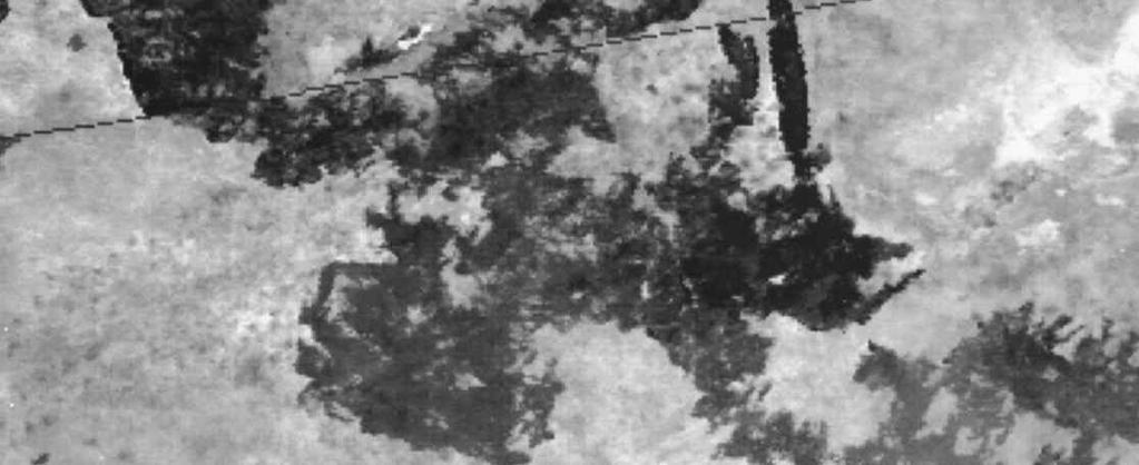
4 1034 D. P. Roy et al. Table 1. Burn scar classi cation thresholds. Class Lower threshold Upper threshold 0 (unburned) 0 m+1 s 1 m+1 s m+2 s 2 m+2 s m+3 s 3 m+3 s m+4 s 4( burned) m+4 s none Class assigned to a pixel if the burn scar index change value is greater than or equal to the lower threshold and is less than the upper threshold. m and s correspond to the mean and standard deviation of burned scar index change values found at the locations of all pixels that were not saturated in the diverent orbits and where a re was detected with high con dence. 3. Data Twenty-four daily (afternoon pass) NOAA-11 AVHRR 1.1 km images sensed from 15 August to 15 September 1989 of an active burn near the Okavango Delta were examined. The data were processed using the Path nder II processing chain which incorporates an improved calibration method and corrects for Rayleigh scattering, ozone and water vapor absorption (El Saleous et al. forthcoming). Cloud screening was performed using the method of Saunders and Kriebel (1988). The re ective component of the middle-infrared channel was computed using the method of Roger and Vermote (1998). Pixels with middle-infrared channel brightness temperatures greater than 320ß K were considered to be saturated. Active res were detected by application of a recent algorithm that uses a contextual method and the nearinfrared and thermal AVHRR channels (Giglio et al. forthcoming). The AVHRR images were corregistered manually with no more than one pixel root mean square error. 4. Results Figures 2(a) and (b) show the normalised diverence vegetation index (NDVI) and the burn scar index respectively for 6 September. This day was selected for illustrative purposes because it is cloud free and appears to show the spatial extent of most of the burning that occurred over the 24 days. The smoke plumes evident in the NDVI image are largely unseen in the burn scar index image which shows a considerably stronger discrimination between the burned and unburned areas. The Okavango Delta (north-west quadrant) appears bright in the burn scar index image because it is highly vegetated and moist, whereas the burned areas to the northeast and south of the delta are dark because of low post-burn moisture and vegetation levels. Figures 2(c) and (d ) show the output of the burn scar detection algorithm applied to the rst twelve days and to the last twelve days of data respectively. Five Figure 2. An area of savanna burning near the Okavango Delta, Botswana, Southern Africa. The area illustrated corresponds to 360 by 360 NOAA-11 AVHRR 1.1 km pixels. (a) Normalised diverence vegetation index image sensed on 6 September (b) Burn scar index image sensed on 6 September (c) Burn scar detection results for the rst twelve days of the 24-day sequence. Shading corresponding to table 1 classes: black= unburned (class 0) and white= burned (class 4). (d ) Burn scar detection results for the last twelve days of the 24-day sequence. Shading corresponding to table 1 classes: black= unburned (class 0) and white= burned (class 4).

")

5 Remote Sensing L etters 1035 (a) (b)


6 1036 D. P. Roy et al. (c) (d)
7 Remote Sensing L etters 1037 burn classes are shown which correspond approximately to the likelihood of burning (table 1). Generally, a strong spatial correspondence is observed between the burn scar detection results and the burned area seen in the NDVI and burn scar index images. It is suspected that some of the isolated pixels labeled as burned, including those along the edges of the Okavango Delta, are mislabelled because of AVHRR data processing problems which include data misregistration and inaccurate cloud detection. 5. Conclusion A burn scar detection algorithm has been described that is based upon thresholding relative temporal changes in a burn scar index using the output of an active- re detection algorithm. The area burned over a period at least equal to the satellite repeat cycle is mapped without iterative spatial or temporal searches and without using xed thresholds except to detect saturated AVHRR pixels. The algorithm may be adapted to incorporate biophysically based thresholds and empirical thresholds derived from other sources of burned area information. Further work is required to investigate the spatial extent over which thresholds can be meaningfully applied because of sensitivity to the land cover and its properties and to the proportions of the pixels that are burned. Work is being performed to validate the algorithm quantitatively in diverent re regimes around the world. The sensitivity of the algorithm to data misregistration and the subsequent impact upon burned area estimates is being investigated. Acknowledgm ents The authors acknowledge and thank Jose M. C. Pereira for his help and advice in the early stages of this work and Nazmi El Saleous for assistance with the Path nder II processing. References Barbosa, P. M., Gregoire, J.-M., and Pereira, J. M. C., 1997, Detection of burned areas in Africa using a multitemporal multithreshold analysis of NOAA-AVHRR-GAC data. In Proceedings of SPIE, Earth Surface Remote Sensing, edited by G. Cecchi, E. Engman, E. Ziloili (SPIE, Bellingham, Washington: SPIE), pp. 67± 75. Eva, H., and Lambin, E. F., Burnt area mapping in Central Africa using ATSR data. International Journal of Remote Sensing, 19, 3473± Giglio, L., Kendall, J. D., and Justice, C. O., Evaluation of global re detection algorithms using simulated AVHRR infrared data. International Journal of Remote Sensing, In Press. IGBP, 1997, De nition and implementation of a global re product derived from AVHRR data. International Geosphere-Biosphere Programme ± Data and Information Systems (IGBP-DIS) Working Paper #17, Report of the 3rd IGBP-DIS Fire Working Group meeting, August 1997, IGBP-DIS o ce, CNRM, 42 avenue G. Coriolis, Toulouse, France. Justice, C. O., Malingreau, J. P., and Setzer, A., 1993, Satellite remote sensing of res: potential and limitation. In Fire in the Environment; Its Ecological, Climatic and Atmospheric Chemical Importance, edited by P. Clutzen and J. Goldmeyer (Chichester: John Wiley and Sons), pp. 77± 88. Kaufman, Y. J., and Remer, L., 1994, Detection of forests using mid-ir re ectance: An application for aerosol studies. IEEE T ransactions on Geoscience and Remote Sensing, 32, 672± 683. Meyer, D., Verstraete, M. M., and Pinty, B., 1995, The evect of surface anisotropy and viewing geometry on the estimation of NDVI from AVHRR. Remote Sensing Reviews, 12, 3± 27.
8 1038 Remote Sensing L etters Pereira, J. M. C., 1998, A comparative evaluation of NOAA/AVHRR vegetation indices for burned surface detection and mapping. IEEE T ransactions on Geoscience and Remote Sensing, 37, 217± 226. Pereira, J. M. C., Chuvieco, E., Beaudoin, A., and Desbois, N., 1997, A review of remote sensing methods for the study of large wildland res, edited by E. Chuvieco, Report of the Mega res Project ENV-CT , August 1997, Universidad de Alcala, Alcala de Henares, Spain. Roger, J. C., and Vermote, E., 1998, Computation and use of the re ectivity at 3.75 mm from AVHRR thermal channels. Remote Sensing of Environment, 64, 103± 114. Saleous, N. El, Vermote, E., Justice, C. O., Townshend, J. R. G., Tucker, C. J., and Goward, S., AVHRR Land Path nder II: Improved algorithms for land studies. International Journal of Remote Sensing, 19, 3473± Saunders, R. W., and Kriebel, K. T., 1988, An improved method for detecting clear sky and cloudy radiances from AVHRR data. International Journal of Remote Sensing, 9, 123± 150. Scholes, R. J., Ward, D., and Justice, C. O., 1996, Emission of trace gases and aerosol particles due to vegetation burning in southern hemisphere Africa. Journal of Geophysical Research, 101, 23677± Wolfe, R. E., Roy, D. P., and Vermote, E., 1998, The MODIS land data storage, gridding and compositing methodology: L2 Grid. IEEE T ransactions on Geoscience and Remote Sensing, 36, 1324± 1338.
The global MODIS burned area product
 The global MODIS burned area product David P. Roy 1, Luigi Boschetti 2, Christopher O. Justice 3 Abstract Earth-observing satellite systems provide the potential for an accurate and timely mapping of burned
Improving the CALIPSO VFM product with Aqua MODIS measurements
 University of Nebraska - Lincoln DigitalCommons@University of Nebraska - Lincoln NASA Publications National Aeronautics and Space Administration 2010 Improving the CALIPSO VFM product with Aqua MODIS measurements
Land Surface Temperature Measurements From the Split Window Channels of the NOAA 7 Advanced Very High Resolution Radiometer John C.
 Land Surface Temperature Measurements From the Split Window Channels of the NOAA 7 Advanced Very High Resolution Radiometer John C. Price Published in the Journal of Geophysical Research, 1984 Presented
GMES: calibration of remote sensing datasets
 GMES: calibration of remote sensing datasets Jeremy Morley Dept. Geomatic Engineering jmorley@ge.ucl.ac.uk December 2006 Outline Role of calibration & validation in remote sensing Types of calibration
POLAR-ORBITING wide-field-of-view sensors provide
 452 IEEE GEOSCIENCE AND REMOTE SENSING LETTERS, VOL. 3, NO. 4, OCTOBER 2006 The Global Impact of Clouds on the Production of MODIS Bidirectional Reflectance Model-Based Composites for Terrestrial Monitoring
Retrieval of middle-infrared reflectance using remote sensing data: the tropical point of view
 Retrieval of middle-infrared reflectance using remote sensing data: the tropical point of view Renata Libonati 1,3 Carlos do Carmo de Portugal e Castro da Camara 1 José Miguel Cardoso Pereira 2 Alberto
Aerosol Optical Depth Variation over European Region during the Last Fourteen Years
 Aerosol Optical Depth Variation over European Region during the Last Fourteen Years Shefali Singh M.Tech. Student in Computer Science and Engineering at Meerut Institute of Engineering and Technology,
Variability of the Seasonally Integrated Normalized Difference Vegetation Index Across the North Slope of Alaska in the 1990s
 INT. J. REMOTE SENSING, 2003, VOL. 24, NO. 5, 1111 1117 Variability of the Seasonally Integrated Normalized Difference Vegetation Index Across the North Slope of Alaska in the 1990s D. STOW*, S. DAESCHNER,
Study of the Influence of Thin Cirrus Clouds on Satellite Radiances Using Raman Lidar and GOES Data
 Study of the Influence of Thin Cirrus Clouds on Satellite Radiances Using Raman Lidar and GOES Data D. N. Whiteman, D. O C. Starr, and G. Schwemmer National Aeronautics and Space Administration Goddard
Inter- Annual Land Surface Variation NAGS 9329
 Annual Report on NASA Grant 1 Inter- Annual Land Surface Variation NAGS 9329 PI Stephen D. Prince Co-I Yongkang Xue April 2001 Introduction This first period of operations has concentrated on establishing
The use of spatial-temporal analysis for noise reduction in MODIS NDVI time series data
 The use of spatial-temporal analysis for noise reduction in MODIS NDVI time series data Julio Cesar de Oliveira 1,2, José Carlos Neves Epiphanio 1, Camilo Daleles Rennó 1 1 Instituto Nacional de Pesquisas
APPLICATIONS WITH METEOROLOGICAL SATELLITES. W. Paul Menzel. Office of Research and Applications NOAA/NESDIS University of Wisconsin Madison, WI
 APPLICATIONS WITH METEOROLOGICAL SATELLITES by W. Paul Menzel Office of Research and Applications NOAA/NESDIS University of Wisconsin Madison, WI July 2004 Unpublished Work Copyright Pending TABLE OF CONTENTS
A Facility for Producing Consistent Remotely Sensed Biophysical Data Products of Australia
 TERRESTRIAL ECOSYSTEM RESEARCH NETWORK - AusCover - A Facility for Producing Consistent Remotely Sensed Biophysical Data Products of Australia June, 2011 Mervyn Lynch Professor of Remote Sensing Curtin
Estimation of ocean contribution at the MODIS near-infrared wavelengths along the east coast of the U.S.: Two case studies
 GEOPHYSICAL RESEARCH LETTERS, VOL. 32, L13606, doi:10.1029/2005gl022917, 2005 Estimation of ocean contribution at the MODIS near-infrared wavelengths along the east coast of the U.S.: Two case studies
Recent Update on MODIS C6 and VIIRS Deep Blue Aerosol Products
 Recent Update on MODIS C6 and VIIRS Deep Blue Aerosol Products N. Christina Hsu, Photo taken from Space Shuttle: Fierce dust front over Libya Corey Bettenhausen, Andrew M. Sayer, and Rick Hansell Laboratory
THE LAND-SAF SURFACE ALBEDO AND DOWNWELLING SHORTWAVE RADIATION FLUX PRODUCTS
 THE LAND-SAF SURFACE ALBEDO AND DOWNWELLING SHORTWAVE RADIATION FLUX PRODUCTS Bernhard Geiger, Dulce Lajas, Laurent Franchistéguy, Dominique Carrer, Jean-Louis Roujean, Siham Lanjeri, and Catherine Meurey
Reduction of Cloud Obscuration in the MODIS Snow Data Product
 59th EASTERN SNOW CONFERENCE Stowe, Vermont USA 2002 Reduction of Cloud Obscuration in the MODIS Snow Data Product GEORGE RIGGS 1 AND DOROTHY K. HALL 2 ABSTRACT A challenging problem in snow mapping is
ANALYSIS OF THE FACTOR WHICH GIVES INFLUENCE TO AVHRR NDVI DATA
 ANALYSIS OF THE FACTOR WHICH GIVES INFLUENCE TO AVHRR NDVI DATA Jong-geol Park and Ryutaro Tateishi Center for Environmental Remote Sensing Chiba University, Japan amon@ceres.cr.chiba-u.ac.jp tateishi@ceres.cr.chiba-u.ac.jp
Remote Sensing Seminar 8 June 2007 Benevento, Italy. Lab 5 SEVIRI and MODIS Clouds and Fires
 Remote Sensing Seminar 8 June 2007 Benevento, Italy Lab 5 SEVIRI and MODIS Clouds and Fires Table: SEVIRI Channel Number, Wavelength (µm), and Primary Application Reflective Bands 1,2 0.635, 0.81 land/cld
THE OPERATIONAL MSG/SEVIRI FIRE RADIATIVE POWER PRODUCT GENERATED AT THE LAND SAF
 THE OPERATIONAL MSG/SEVIRI FIRE RADIATIVE POWER PRODUCT GENERATED AT THE LAND SAF Y. Govaerts (1), M. Wooster (2), A. Lattanzio (3), G. Roberts (2), P. Freeborn (2), W. Xu (2) and I. Trigo (4) (1) EUMETSAT,
GLOBAL/CONTINENTAL LAND COVER MAPPING AND MONITORING
 GLOBAL/CONTINENTAL LAND COVER MAPPING AND MONITORING Ryutaro Tateishi, Cheng Gang Wen, and Jong-Geol Park Center for Environmental Remote Sensing (CEReS), Chiba University 1-33 Yayoi-cho Inage-ku Chiba
1.2 UTILIZING MODIS SATELLITE OBSERVATIONS IN NEAR-REAL-TIME TO IMPROVE AIRNow NEXT DAY FORECAST OF FINE PARTICULATE MATTER, PM2.5
 1.2 UTILIZING MODIS SATELLITE OBSERVATIONS IN NEAR-REAL-TIME TO IMPROVE AIRNow NEXT DAY FORECAST OF FINE PARTICULATE MATTER, PM2.5 James Szykman*, John White US EPA, Office of Air Quality Planning and
AGRICULTURE DROUGHT AND FOREST FIRE MONITORING IN CHONGQING CITY WITH MODIS AND METEOROLOGICAL OBSERVATIONS *
 AGRICULTURE DROUGHT AND FOREST FIRE MONITORING IN CHONGQING CITY WITH MODIS AND METEOROLOGICAL OBSERVATIONS * HONGRUI ZHAO a ZHONGSHI TANG a, BIN YANG b AND MING ZHAO a a 3S Centre, Tsinghua University,
Satellite remote sensing of aerosols & clouds: An introduction
 Satellite remote sensing of aerosols & clouds: An introduction Jun Wang & Kelly Chance April 27, 2006 junwang@fas.harvard.edu Outline Principals in retrieval of aerosols Principals in retrieval of water
Lecture Topics. 1. Vegetation Indices 2. Global NDVI data sets 3. Analysis of temporal NDVI trends
 Lecture Topics 1. Vegetation Indices 2. Global NDVI data sets 3. Analysis of temporal NDVI trends Why use NDVI? Normalize external effects of sun angle, viewing angle, and atmospheric effects Normalize
METEOSAT SECOND GENERATION DATA FOR ASSESSMENT OF SURFACE MOISTURE STATUS
 METEOSAT SECOND GENERATION DATA FOR ASSESSMENT OF SURFACE MOISTURE STATUS Simon Stisen (1), Inge Sandholt (1), Rasmus Fensholt (1) (1) Institute of Geography, University of Copenhagen, Oestervoldgade 10,
Lectures 7 and 8: 14, 16 Oct Sea Surface Temperature
 Lectures 7 and 8: 14, 16 Oct 2008 Sea Surface Temperature References: Martin, S., 2004, An Introduction to Ocean Remote Sensing, Cambridge University Press, 454 pp. Chapter 7. Robinson, I. S., 2004, Measuring
Comparison of MSG-SEVIRI and SPOT-VEGETATION data for vegetation monitoring over Africa
 Comparison of MSG-SEVIRI and SPOT-VEGETATION data for vegetation monitoring over Africa Bernard LACAZE CNRS UMR 8586 PRODIG Pôle Image et Campus Spatial, Université Paris Diderot Paris 7 Objectives Comparison
ESTIMATION OF ATMOSPHERIC COLUMN AND NEAR SURFACE WATER VAPOR CONTENT USING THE RADIANCE VALUES OF MODIS
 ESTIMATION OF ATMOSPHERIC COLUMN AND NEAR SURFACE WATER VAPOR CONTENT USIN THE RADIANCE VALUES OF MODIS M. Moradizadeh a,, M. Momeni b, M.R. Saradjian a a Remote Sensing Division, Centre of Excellence
A HIGH RESOLUTION EUROPEAN CLOUD CLIMATOLOGY FROM 15 YEARS OF NOAA/AVHRR DATA
 A HIGH RESOLUTION EUROPEAN CLOUD CLIMATOLOGY FROM 15 YEARS OF NOAA/AVHRR DATA R. Meerkötter 1, G. Gesell 2, V. Grewe 1, C. König 1, S. Lohmann 1, H. Mannstein 1 Deutsches Zentrum für Luft- und Raumfahrt
112 IEEE GEOSCIENCE AND REMOTE SENSING LETTERS, VOL. 3, NO. 1, JANUARY David P. Roy, Luigi Boschetti, and Simon N. Trigg
 112 IEEE GEOSCIENCE AND REMOTE SENSING LETTERS, VOL. 3, NO. 1, JANUARY 2006 Remote Sensing of Fire Severity: Assessing the Performance of the Normalized Burn Ratio David P. Roy, Luigi Boschetti, and Simon
Tracking On-orbit Radiometric Accuracy and Stability of Suomi NPP VIIRS using Extended Low Latitude SNOs
 Tracking On-orbit Radiometric Accuracy and Stability of Suomi NPP VIIRS using Extended Low Latitude SNOs Sirish Uprety a Changyong Cao b Slawomir Blonski c Xi Shao c Frank Padula d a CIRA, Colorado State
PLEASE SCROLL DOWN FOR ARTICLE
 This article was downloaded by:[university of Maryland] On: 13 October 2007 Access Details: [subscription number 731842062] Publisher: Taylor & Francis Informa Ltd Registered in England and Wales Registered
Statistical comparison of MISR, ETMz and MODIS land surface reflectance and albedo products of the BARC land validation core site, USA
 INT. J. REMOTE SENSING, 20JANUARY, 2004, VOL. 25, NO. 2, 409 422 Statistical comparison of MISR, ETMz and MODIS land surface reflectance and albedo products of the BARC land validation core site, USA H.
Deforestation and Degradation in Central and Southern Africa. Project Title: "Deforestation and Degradation in Central and Southern Africa"
 Deforestation and Degradation in Central and Southern Africa Project Title: "Deforestation and Degradation in Central and Southern Africa" Description: An integrated land degradation and deforestation
Module 3 False ideas and other theoretical issues
 FORmation of Multi-disciplinary Approaches to Training in Earth Observation Erasmus Intensive Programmes Module 3 False ideas and other theoretical issues FORmation of Multi-disciplinary Approaches to
Comparison of NASA AIRS and MODIS Land Surface Temperature and Infrared Emissivity Measurements from the EOS AQUA platform
 Comparison of NASA AIRS and MODIS Land Surface Temperature and Infrared Emissivity Measurements from the EOS AQUA platform Robert Knuteson, Hank Revercomb, Dave Tobin University of Wisconsin-Madison 16
Comparison of cloud statistics from Meteosat with regional climate model data
 Comparison of cloud statistics from Meteosat with regional climate model data R. Huckle, F. Olesen, G. Schädler Institut für Meteorologie und Klimaforschung, Forschungszentrum Karlsruhe, Germany (roger.huckle@imk.fzk.de
Methane Sensing Flight of Scanning HIS over Hutchinson, KS, 31 March 2001
 Methane Sensing Flight of Scanning HIS over Hutchinson, KS, 31 March 2001 Hank Revercomb, Chris Moeller, Bob Knuteson, Dave Tobin, Ben Howell University of Wisconsin, Space Science and Engineering Center
Impact of NASA EOS data on the scientific literature: 16 years of published research results from Terra, Aqua, Aura, and Aquarius
 Impact of NASA EOS data on the scientific literature: 16 years of published research results from Terra, Aqua, Aura, and Aquarius Gene R. Major NASA Goddard Library Nebulous Connections April 4, 2017 RESACs/RA
In-flight Calibration Techniques Using Natural Targets. CNES Activities on Calibration of Space Sensors
 In-flight Calibration Techniques Using Natural Targets CNES Activities on Calibration of Space Sensors Bertrand Fougnie, Patrice Henry (DCT/SI, CNES, Toulouse, France) In-flight Calibration using Natural
A high spectral resolution global land surface infrared emissivity database
 A high spectral resolution global land surface infrared emissivity database Eva E. Borbas, Robert O. Knuteson, Suzanne W. Seemann, Elisabeth Weisz, Leslie Moy, and Hung-Lung Huang Space Science and Engineering
An automatic method for burn scar mapping using support vector machines
 International Journal of Remote Sensing Vol. 30, No. 3, 10 February 2009, 577 594 An automatic method for burn scar mapping using support vector machines X. CAO{{, J. CHEN*{, B. MATSUSHITA, H. IMURA" and
Cloud Masking for Remotely Sensed Data Using Spectral and Principal Components Analysis
 ETASR - Engineering, Technology & Applied Science Research Vol. 2, o. 3, 2012, 221-225 221 Cloud Masking for Remotely Sensed Data Using Spectral and Principal Components Analysis Asmala Ahmad Faculty of
What are Aerosols? Suspension of very small solid particles or liquid droplets Radii typically in the range of 10nm to
 What are Aerosols? Suspension of very small solid particles or liquid droplets Radii typically in the range of 10nm to 10µm Concentrations decrease exponentially with height N(z) = N(0)exp(-z/H) Long-lived
Cross-Sensor Continuity Science Algorithm
 Cross-Sensor Continuity Science Algorithm - Long Term Vegetation Index and Phenology Workshop - Javzan Tsend-Ayush and Tomoaki Miura Department of Natural Resources and Environmental Management University
Spectral surface albedo derived from GOME-2/Metop measurements
 Spectral surface albedo derived from GOME-2/Metop measurements Bringfried Pflug* a, Diego Loyola b a DLR, Remote Sensing Technology Institute, Rutherfordstr. 2, 12489 Berlin, Germany; b DLR, Remote Sensing
Methods review for the Global Land Cover 2000 initiative Presentation made by Frédéric Achard on November 30 th 2000
 Methods review for the Global Land Cover 2000 initiative Presentation made by Frédéric Achard on November 30 th 2000 1. Contents Objectives Specifications of the GLC-2000 exercise Strategy for the analysis
Application of Aura/OMI PBL SO 2 product for estimating SO 2 emissions and future enhancements from new satellite missions
 Application of Aura/OMI PBL SO 2 product for estimating SO 2 emissions and future enhancements from new satellite missions 1 N. Krotkov, 2 V. Fioletov, 3,1 K. Yang, 4,1 Can Li, 3 R. Dickerson & Aura/OMI
Sensitivity Study of the MODIS Cloud Top Property
 Sensitivity Study of the MODIS Cloud Top Property Algorithm to CO 2 Spectral Response Functions Hong Zhang a*, Richard Frey a and Paul Menzel b a Cooperative Institute for Meteorological Satellite Studies,
P1.34 MULTISEASONALVALIDATION OF GOES-BASED INSOLATION ESTIMATES. Jason A. Otkin*, Martha C. Anderson*, and John R. Mecikalski #
 P1.34 MULTISEASONALVALIDATION OF GOES-BASED INSOLATION ESTIMATES Jason A. Otkin*, Martha C. Anderson*, and John R. Mecikalski # *Cooperative Institute for Meteorological Satellite Studies, University of
A AVHRR NDVI dataset for Svalbard. Stian Solbø, Inge Lauknes, Cecilie Sneberg Grøtteland, Stine Skrunes, Hannah Vickers, Kjell Arild Høgda
 A 1986-2014 AVHRR NDVI dataset for Svalbard Stian Solbø, Inge Lauknes, Cecilie Sneberg Grøtteland, Stine Skrunes, Hannah Vickers, Kjell Arild Høgda AVHRR series of satellites/instruments Satellite name
VIIRS narrowband to broadband land surface albedo conversion: formula and validation
 International Journal of Remote Sensing Vol. 26, No. 5, 10 March 2005, 1019 1025 VIIRS narrowband to broadband land surface albedo conversion: formula and validation S. LIANG*{, Y. YU{ and T. P. DEFELICE{
The Challenge of. Guy Brasseur
 The Challenge of Monitoring and Predicting Chemical Weather Guy Brasseur Introduction: What is Chemical Weather? What is Chemical Weather? Local, regional, and global distributions of important trace gases
VIIRS SDR Cal/Val: S-NPP Update and JPSS-1 Preparations
 VIIRS SDR Cal/Val: S-NPP Update and JPSS-1 Preparations VIIRS SDR Cal/Val Posters: Xi Shao Zhuo Wang Slawomir Blonski ESSIC/CICS, University of Maryland, College Park NOAA/NESDIS/STAR Affiliate Spectral
Comparison of NASA AIRS and MODIS Land Surface Temperature and Infrared Emissivity Measurements from the EOS AQUA platform
 Comparison of NASA AIRS and MODIS Land Surface Temperature and Infrared Emissivity Measurements from the EOS AQUA platform Robert Knuteson, Steve Ackerman, Hank Revercomb, Dave Tobin University of Wisconsin-Madison
What is so great about nighttime VIIRS data for the detection and characterization of combustion sources?
 Proceedings of the Asia-Pacific Advanced Network 2013 v. 35, p. 33-48. http://dx.doi.org/10.7125/apan.35.5 ISSN 2227-3026 What is so great about nighttime VIIRS data for the detection and characterization
AATSR atmospheric correction
 AATSR atmospheric correction Objective: Retrieval of aerosol opacity and bidirectional reflectance over land surface Talk structure Science background and objectives Dual-angle method Validation and satellite
Detection of land cover changes using MODIS 250 m data
 Remote Sensing of Environment 83 (2002) 336 350 www.elsevier.com/locate/rse Detection of land cover changes using MODIS 250 m data X. Zhan a,1, R.A. Sohlberg a, *, J.R.G. Townshend a,b,c, C. DiMiceli a,
RETRIEVAL OF AEROSOL OPTICAL DEPTH OVER URBAN AREAS USING TERRA/MODIS DATA
 RETRIEVAL OF AEROSOL OPTICAL DEPTH OVER URBAN AREAS USING TERRA/MODIS DATA X. Q. Zhang a, *, L. P. Yang b, Y. Yamaguchi a a Dept. of Earth and Environmental Sciences, Graduate School of Environmental Studies,
Assimilation of hyperspectral infrared sounder radiances in the French global numerical weather prediction ARPEGE model
 Assimilation of hyperspectral infrared sounder radiances in the French global numerical weather prediction ARPEGE model N. Fourrié, V. Guidard, M. Dahoui, T. Pangaud, P. Poli and F. Rabier CNRM-GAME, Météo-France
Lecture 19: Operational Remote Sensing in Visible, IR, and Microwave Channels
 MET 4994 Remote Sensing: Radar and Satellite Meteorology MET 5994 Remote Sensing in Meteorology Lecture 19: Operational Remote Sensing in Visible, IR, and Microwave Channels Before you use data from any
SIMULATION OF SPACEBORNE MICROWAVE RADIOMETER MEASUREMENTS OF SNOW COVER FROM IN-SITU DATA AND EMISSION MODELS
 SIMULATION OF SPACEBORNE MICROWAVE RADIOMETER MEASUREMENTS OF SNOW COVER FROM IN-SITU DATA AND EMISSION MODELS Anna Kontu 1 and Jouni Pulliainen 1 1. Finnish Meteorological Institute, Arctic Research,
Using Sun Glint to Check the Relative Calibration of Reflected Spectral Radiances
 1480 J O U R N A L O F A T M O S P H E R I C A N D O C E A N I C T E C H N O L O G Y VOLUME 22 Using Sun Glint to Check the Relative Calibration of Reflected Spectral Radiances GUNNAR LUDERER,* JAMES A.
Global Broadband IR Surface Emissivity Computed from Combined ASTER and MODIS Emissivity over Land (CAMEL)
") P76 Global Broadband IR Surface Emissivity Computed from Combined ASTER and MODIS Emissivity over Land (CAMEL) Michelle Feltz, Eva Borbas, Robert Knuteson, Glynn Hulley*, Simon Hook* University of Wisconsin-Madison
P76 Global Broadband IR Surface Emissivity Computed from Combined ASTER and MODIS Emissivity over Land (CAMEL) Michelle Feltz, Eva Borbas, Robert Knuteson, Glynn Hulley*, Simon Hook* University of Wisconsin-Madison
GLAS Team Member Quarterly Report
 GLAS Team Member Quarterly Report Thomas A. Herring, Katherine J. Quinn, An Nguyen, Monchaya Piboon Massachusetts Institute of Technology Period: 4/1/2002 to 6/30/2002 Options for Estimating Multiple Scattering
On the Satellite Determination of Multilayered Multiphase Cloud Properties. Science Systems and Applications, Inc., Hampton, Virginia 2
 JP1.10 On the Satellite Determination of Multilayered Multiphase Cloud Properties Fu-Lung Chang 1 *, Patrick Minnis 2, Sunny Sun-Mack 1, Louis Nguyen 1, Yan Chen 2 1 Science Systems and Applications, Inc.,
REMOTE SENSING AND GIS AS POLLUTION MODEL VALIDATION AND EMISSION ASSESSMENT TOOLS. Athens, Athens, Greece
 REMOTE SENSING AND GIS AS POLLUTION MODEL VALIDATION AND EMISSION ASSESSMENT TOOLS Michael Petrakis 1, Theodora Kopania 1, David Briggs 2, Asbjorn Aaheim 3, Gerard Hoek 4, Gavin Shaddick 5, Adrianos Retalis
SOIL MOISTURE MAPPING THE SOUTHERN U.S. WITH THE TRMM MICROWAVE IMAGER: PATHFINDER STUDY
 SOIL MOISTURE MAPPING THE SOUTHERN U.S. WITH THE TRMM MICROWAVE IMAGER: PATHFINDER STUDY Thomas J. Jackson * USDA Agricultural Research Service, Beltsville, Maryland Rajat Bindlish SSAI, Lanham, Maryland
Performance of the AIRS/AMSU And MODIS Soundings over Natal/Brazil Using Collocated Sondes: Shadoz Campaign
 Performance of the AIRS/AMSU And MODIS Soundings over Natal/Brazil Using Collocated Sondes: Shadoz Campaign 2004-2005 Rodrigo Augusto Ferreira de Souza, Jurandir Rodrigues Ventura, Juan Carlos Ceballos
Interpretation of Polar-orbiting Satellite Observations. Atmospheric Instrumentation
 Interpretation of Polar-orbiting Satellite Observations Outline Polar-Orbiting Observations: Review of Polar-Orbiting Satellite Systems Overview of Currently Active Satellites / Sensors Overview of Sensor
Seasonal, intraseasonal, and interannual variability of global land fires and their effects on atmospheric aerosol distribution
 JOURNAL OF GEOPHYSICAL RESEARCH, VOL. 107, NO. D23, 4697, doi:10.1029/2002jd002331, 2002 Seasonal, intraseasonal, and interannual variability of global land fires and their effects on atmospheric aerosol
MODIS ATMOSPHERIC PROFILES PRODUCT IN FINLAND A FEASIBILITY STUDY
 MODIS ATMOSPHERIC PROFILES PRODUCT IN FINLAND A FEASIBILITY STUDY Sauli Joro Finnish Meteorological Institute P.O.Box 503, FIN-00101 Helsinki, FINLAND sauli.joro@fmi.fi ABSTRACT The prediction of convection
Influence of Clouds and Aerosols on the Earth s Radiation Budget Using Clouds and the Earth s Radiant Energy System (CERES) Measurements
 Measurements") Influence of Clouds and Aerosols on the Earth s Radiation Budget Using Clouds and the Earth s Radiant Energy System (CERES) Measurements Norman G. Loeb Hampton University/NASA Langley Research Center Bruce
Influence of Clouds and Aerosols on the Earth s Radiation Budget Using Clouds and the Earth s Radiant Energy System (CERES) Measurements Norman G. Loeb Hampton University/NASA Langley Research Center Bruce
Introduction to Satellite Derived Vegetation Indices
 Introduction to the Use of Geospatial Information Technology for Drought Risk Management 13-17 November, 2017 Tonle Bassac II Restaurant, Phnom Penh, Cambodia Introduction to Satellite Derived Vegetation
Assessing the potential of VEGETATION sensor data for mapping snow and ice cover: a Normalized DiVerence Snow and Ice Index
 int. j. remote sensing, 2001, vol. 22, no. 13, 2479 2487 Assessing the potential of VEGETATION sensor data for mapping snow and ice cover: a Normalized DiVerence Snow and Ice Index XIANGMING XIAO Complex
Remote Sensing and Modeling of Wildfires
 Remote Sensing and Modeling of Wildfires Michele A. Kuester Ball Aerospace & Technologies Corp. 1600 Commerce Street Boulder, CO 80301 John Marshall and William J. Emery University of Colorado Boulder,
P3.24 EVALUATION OF MODERATE-RESOLUTION IMAGING SPECTRORADIOMETER (MODIS) SHORTWAVE INFRARED BANDS FOR OPTIMUM NIGHTTIME FOG DETECTION
 SHORTWAVE INFRARED BANDS FOR OPTIMUM NIGHTTIME FOG DETECTION") P3.24 EVALUATION OF MODERATE-RESOLUTION IMAGING SPECTRORADIOMETER (MODIS) SHORTWAVE INFRARED BANDS FOR OPTIMUM NIGHTTIME FOG DETECTION 1. INTRODUCTION Gary P. Ellrod * NOAA/NESDIS/ORA Camp Springs, MD
P3.24 EVALUATION OF MODERATE-RESOLUTION IMAGING SPECTRORADIOMETER (MODIS) SHORTWAVE INFRARED BANDS FOR OPTIMUM NIGHTTIME FOG DETECTION 1. INTRODUCTION Gary P. Ellrod * NOAA/NESDIS/ORA Camp Springs, MD
Challenges for the operational assimilation of satellite image data in agrometeorological models
 Challenges for the operational assimilation of satellite image data in agrometeorological models Mark Danson Centre for Environmental Systems Research, University of Salford, UK 0 Objectives The main objective
Remote Sensing Based Inversion of Gap Fraction for Determination of Leaf Area Index. Alemu Gonsamo 1 and Petri Pellikka 1
 Remote Sensing Based Inversion of Gap Fraction for Determination of Leaf Area Index Alemu Gonsamo and Petri Pellikka Department of Geography, University of Helsinki, P.O. Box, FIN- Helsinki, Finland; +-()--;
MODIS Snow Cover Mapping Decision Tree Technique: Snow and Cloud Discrimination
 67 th EASTERN SNOW CONFERENCE Jiminy Peak Mountain Resort, Hancock, MA, USA 2010 MODIS Snow Cover Mapping Decision Tree Technique: Snow and Cloud Discrimination GEORGE RIGGS 1, AND DOROTHY K. HALL 2 ABSTRACT
DETECTION OF HOTSPOTS IN NOAA/AVHRR IMAGES USING PRINCIPAL COMPONENT ANALYSIS AND INFORMATION FUSION TECHNIQUE
 DETECTION OF HOTSPOTS IN NOAA/AVHRR IMAGES USING PRINCIPAL COMPONENT ANALYSIS AND INFORMATION FUSION TECHNIQUE R. S. Gautam, D. Singh, A. Mittal {rsgcsdec@iitr.ernet.in, dharmfec@iitr.ernet.in, ankumfec@iitr.ernet.in}
Auxiliary Materials for Paper. Widespread Decline in Greenness of Amazonian Vegetation Due to the 2010 Drought
 Auxiliary Materials for Paper Widespread Decline in Greenness of Amazonian Vegetation Due to the 2010 Drought Liang Xu, 1* Arindam Samanta, 2* Marcos H. Costa, 3 Sangram Ganguly, 4 Ramakrishna R. Nemani,
Identifying the regional thermal-ir radiative signature of mineral dust with MODIS
 GEOPHYSICAL RESEARCH LETTERS, VOL. 32, L16803, doi:10.1029/2005gl023092, 2005 Identifying the regional thermal-ir radiative signature of mineral dust with MODIS Anton Darmenov and Irina N. Sokolik School
CONTRAILS FROM (A)ATSR(2) DATA
ATSR(2) DATA") CONTRAILS FROM (A)ATSR(2) DATA Hermann Mannstein and Rüdiger Büll Deutsches Zentrum für Luft- und Raumfahrt, Oberpfaffenhofen, 82230 Wessling, Germany ABSTRACT/RESUME The DLR contrail detection algorithm
CONTRAILS FROM (A)ATSR(2) DATA Hermann Mannstein and Rüdiger Büll Deutsches Zentrum für Luft- und Raumfahrt, Oberpfaffenhofen, 82230 Wessling, Germany ABSTRACT/RESUME The DLR contrail detection algorithm
DERIVING ATMOSPHERIC MOTION VECTORS FROM AIRS MOISTURE RETRIEVAL DATA
 DERIVING ATMOSPHERIC MOTION VECTORS FROM AIRS MOISTURE RETRIEVAL DATA David Santek 1, Sharon Nebuda 1, Christopher Velden 1, Jeff Key 2, Dave Stettner 1 1 Cooperative Institute for Meteorological Satellite
What other observations are needed in addition to Fs for a robust GPP estimate?
 What other observations are needed in addition to Fs for a robust GPP estimate? Luis Guanter Free University of Berlin, Germany With contributions from Joanna Joiner & Betsy Middleton NASA Goddard Space
SATELLITE RETRIEVAL OF AEROSOL PROPERTIES OVER BRIGHT REFLECTING DESERT REGIONS
 SATELLITE RETRIEVAL OF AEROSOL PROPERTIES OVER BRIGHT REFLECTING DESERT REGIONS Tilman Dinter 1, W. von Hoyningen-Huene 1, A. Kokhanovsky 1, J.P. Burrows 1, and Mohammed Diouri 2 1 Institute of Environmental
Greening of Arctic: Knowledge and Uncertainties
 Greening of Arctic: Knowledge and Uncertainties Jiong Jia, Hesong Wang Chinese Academy of Science jiong@tea.ac.cn Howie Epstein Skip Walker Moscow, January 28, 2008 Global Warming and Its Impact IMPACTS
CLOUD CLASSIFICATION AND CLOUD PROPERTY RETRIEVAL FROM MODIS AND AIRS
 6.4 CLOUD CLASSIFICATION AND CLOUD PROPERTY RETRIEVAL FROM MODIS AND AIRS Jun Li *, W. Paul Menzel @, Timothy, J. Schmit @, Zhenglong Li *, and James Gurka # *Cooperative Institute for Meteorological Satellite
Radiative Climatology of the North Slope of Alaska and the Adjacent Arctic Ocean
 Radiative Climatology of the North Slope of Alaska and the Adjacent Arctic Ocean C. Marty, R. Storvold, and X. Xiong Geophysical Institute University of Alaska Fairbanks, Alaska K. H. Stamnes Stevens Institute
Spectral surface emissivity for use in assimilation of IR radiance data over land
 Spectral surface emissivity for use in assimilation of IR radiance data over land 1 2 Małgorzata Szczech-Gajewska, Florence Rabier 1 Institute of Meteorology and Water Management ul. P. Borowego 14, Kraków,
Cloud screening and snow detection with MERIS. Rene Preusker, Jürgen Fischer, Carsten Brockmann, Marco Zühlke, Uwe krämer, Anja Hünerbein
 Cloud screening and snow detection with MERIS Rene Preusker, Jürgen Fischer, Carsten Brockmann, Marco Zühlke, Uwe krämer, Anja Hünerbein Prelude The following algorithm has been compiled in the frame of
Data assimilation of IASI radiances over land.
 Data assimilation of IASI radiances over land. PhD supervised by Nadia Fourrié, Florence Rabier and Vincent Guidard. 18th International TOVS Study Conference 21-27 March 2012, Toulouse Contents 1. IASI
Comparison of near-infrared and thermal infrared cloud phase detections
 Click Here for Full Article JOURNAL OF GEOPHYSICAL RESEARCH, VOL. 111,, doi:10.1029/2006jd007140, 2006 Comparison of near-infrared and thermal infrared cloud phase detections Petr Chylek, 1 S. Robinson,
ANALYSIS AND VALIDATION OF A METHODOLOGY TO EVALUATE LAND COVER CHANGE IN THE MEDITERRANEAN BASIN USING MULTITEMPORAL MODIS DATA
 PRESENT ENVIRONMENT AND SUSTAINABLE DEVELOPMENT, NR. 4, 2010 ANALYSIS AND VALIDATION OF A METHODOLOGY TO EVALUATE LAND COVER CHANGE IN THE MEDITERRANEAN BASIN USING MULTITEMPORAL MODIS DATA Mara Pilloni
RTTOV 10 Theory & Exercise
 RTTOV 10 Theory & Exercise Ø Overview of RTTOVS Radiative Transfer Model q Gases Absorption (water Vapor & other trace gases) q Aerosol/Clouds Scattering and Absorption q Surface Emissivity/Reflectivity
FIRST VALIDATION OF MERIS AEROSOL PRODUCT OVER LAND
 ABSTRACT FIRST VALIDATION OF MERIS AEROSOL PRODUCT OVER LAND Didier Ramon (1), Richard Santer (2), Jerôme Vidot (2) 1. HYGEOS, 191 rue N. Appert, 59650 Villeneuve d Ascq, France, dr@hygeos.com 2. Université
The NOAA/NESDIS/STAR IASI Near Real-Time Product Processing and Distribution System
 The NOAA/NESDIS/STAR Near Real-Time Product Processing and Distribution System W. Wolf 2, T. King 1, Z. Cheng 1, W. Zhou 1, H. Sun 1, P. Keehn 1, L. Zhou 1, C. Barnet 2, and M. Goldberg 2 1 QSS Group Inc,
CLIMATE CHANGE Albedo Forcing ALBEDO FORCING
 ALBEDO FORCING Albedo forcing is the hypothesis that variations in the Earth s reflectance of solar radiation can bring about global climate change. This hypothesis is undeniable in principle; since virtually