Latitude/Longitude: Message in a Bottle
|
|
|
- Edward Poole
- 6 years ago
- Views:
Transcription
1 Latitude/Longitude: Message in a Bottle Glenda Sullivan OKAGE Teacher Consultant, Lawton, Oklahoma World Geography Academy Session III Wednesday, November 17, 2010 University of Oklahoma, Norman Materials may only be reproduced for the classroom and presentations when proper acknowledgement is given to the author and the Oklahoma Alliance for Geographic Education. 100 East Boyd, SEC Rm 442 Norman, OK x okage@ou.edu


2 Glenda Sullivan Oklahoma Alliance for Geographic Education All materials may be reproduced for the classroom and presentations only when proper acknowledgement is given to the author and the Oklahoma Alliance for Geographic Education.
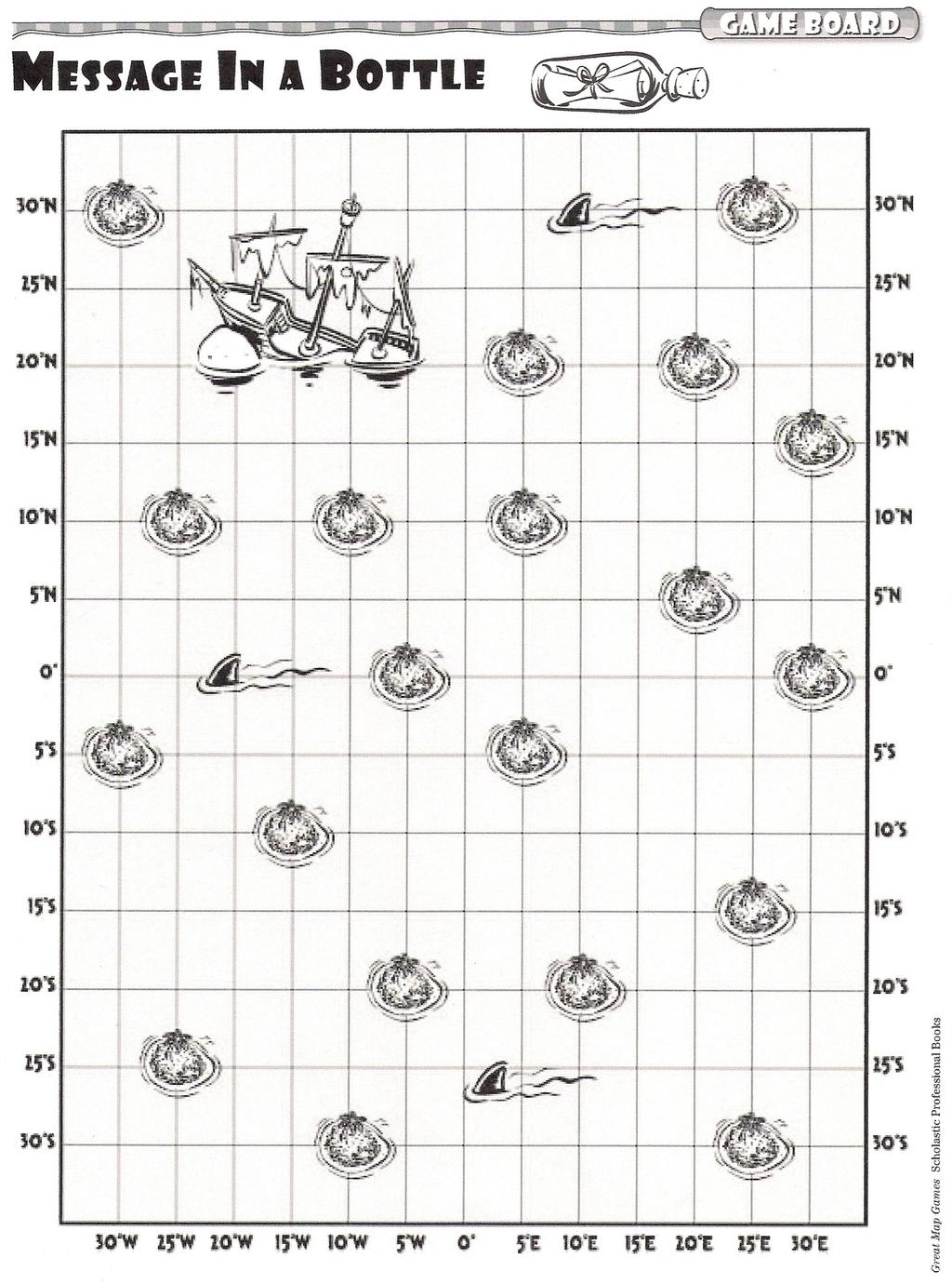
3 Glenda Sullivan, OKAGE TC Lawton, Oklahoma LATITUDE/LONGITUDE: MESSAGE IN A BOTTLE Grade Level: 6th-7th Purpose/Overview: Students will become more proficient in finding absolute locations by playing a board game which employs latitude and longitude coordinates to locate survivors of a shipwreck. National Geography Standards from Geography for Life Geographic Elements & Standards: Standard 1 The World in Spatial Terms: how to use maps and other geographic representations, tools, and technologies to acquire, process, and report information from a spatial perspective. Oklahoma Priority Academic Student Skills: Grade 6 World Studies: 1.2 Identify, evaluate, and draw conclusions from different kinds of maps, graphs, charts, diagrams, timelines, and other representations such as photographs and satellite-produced images or computer-based technologies. 2.1 Apply the concepts of scale, orientation, latitude and longitude, and physical regions. Grade 7 World Geography 1.2 Apply the concepts of scale, distance, direction, relative location, latitude and longitude. 6.1 Evaluate and draw conclusions from different kinds of maps, graphs, charts, diagrams, and other sources and representations (e.g., aerial and shuttle photographs, satellite-produced images, the geographic information system (GIS), atlases, almanacs, and computer-based technologies). Geographic Themes: Location Objectives: 1. Students will review the concept of latitude and longitude. 2. Students will understand that by using latitude/longitude coordinates, absolute locations can easily be found on a map. 3. Students will become more competent in finding absolute locations by playing a board game which employs latitude and longitude coordinates to locate survivors of a shipwreck.
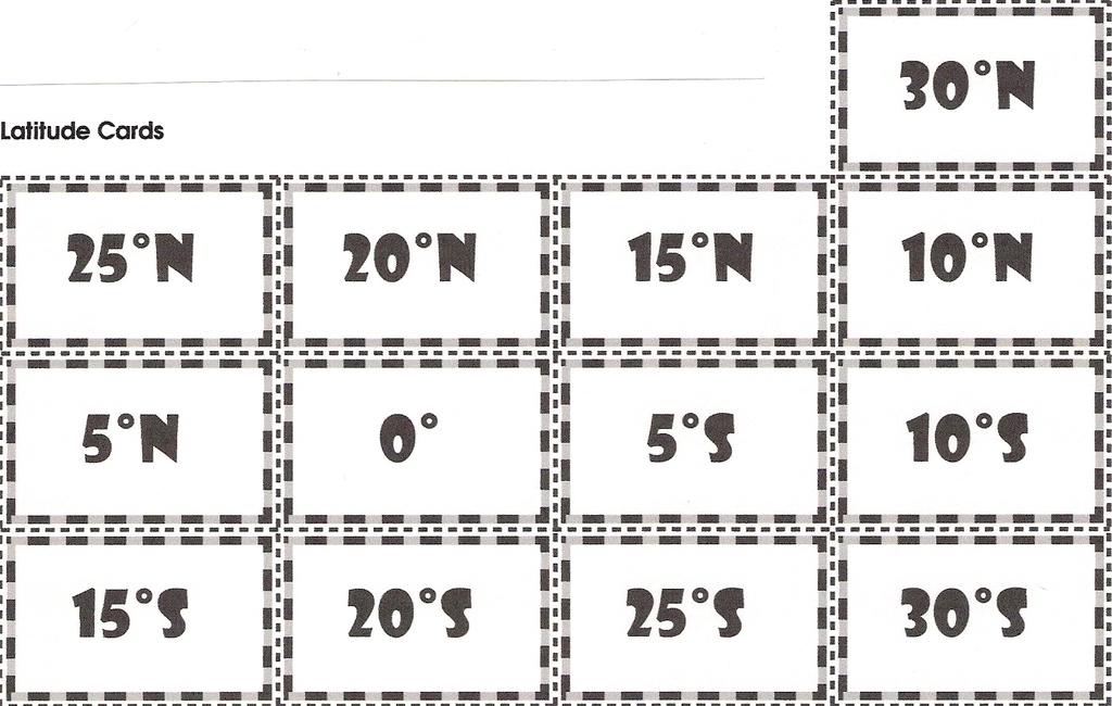
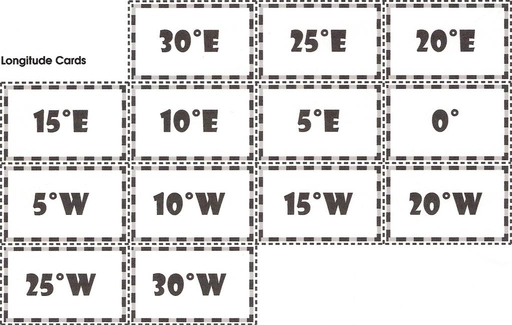
4 Materials: 1. Message in a Bottle Game Board (attached to this lesson) 2. Latitude and Longitude Cards attached to this lesson (Cut apart and put in separate envelopes labeled Latitude and Longitude) Castaway Markers (pennies) Time Frame: 1 class period Procedures: 1. Show PowerPoint Latitude/Longitude: Message in a Bottle to review the following concepts of latitude and longitude: The equator (0º) is the starting point for measuring latitude. Latitude lines are horizontal lines that run parallel to the equator; those above the equator denote north (N) latitude while those below the equator denote south (S) latitude. The prime meridian (0º) is the starting point for measuring longitude. Vertical longitude lines to the right of the prime meridian denote east (E) longitude while those to the left of the prime meridian denote west (W) longitude. Latitude is always stated first. (Example: 40ºN, 100ºW) 0º latitude and 0º longitude are never labeled with a direction. Examples: 0º, 20ºE and 40ºN, 0º (Remember, latitude is written first.) 2. The following example is a fun way to help Oklahoma students remember to locate latitude first: if the student is an OU fan, think over and up; if the student is an OSU fan, think over and straight up. 3. Divide students into groups of two. Play "Message in a Bottle board game. (Instructions, latitude/longitude cards and pattern for game board are attached.) Adapted from the following website: pdf Assessment: Participation grade for playing the game Message in a Bottle which employs latitude/longitude skills. Resources: About.com: Discover the Secrets of Parallels and Meridians World map with latitude, longitude, equator and prime meridian lines Illustrations of lines of latitude and longitude Extension and Enrichment 1. Latitude/longitude is a concept on which students continually need practice to maintain the skill. Give students several latitude/longitude locations for each unit of study throughout the school year.

5
6
7
Touring Around the Islands of Atlantic Canada
 Lesson Overview Touring Around the Islands of Atlantic Canada In this lesson, students will examine the history and heritage of the islands of Atlantic Canada and examine their similarities and differences.
Latitude and Longitude. Begin
 Latitude and Longitude Begin The Earth is divided in two halves, the top half is called the northern hemisphere, and the bottom half is called the southern hemisphere. The dividing line between the two
Nebraska s Place in the World
 Geographic Educators of Nebraska Advocating geographic education for all Nebraskans Nebraska s Place in the World Students will use lines of latitude and longitude to locate cities within the state and
Your web browser (Safari 7) is out of date. For more security, comfort and the best experience on this site: Update your browser Ignore
 is out of date. For more security, comfort and the best experience on this site: Update your browser Ignore") Your web browser (Safari 7) is out of date. For more security, comfort and the best experience on this site: Update your browser Ignore Activitydevelop Educator Version INTRO DUCTIO N TO L ATITU DE AND
Your web browser (Safari 7) is out of date. For more security, comfort and the best experience on this site: Update your browser Ignore Activitydevelop Educator Version INTRO DUCTIO N TO L ATITU DE AND
Latitude and Longitude Pre Test
 Name Date Latitude and Longitude Pre Test Multiple Choice Directions: For questions, 1 10 circle the answer that letter that best answers the question. Each question is worth 1 point each. 1. To locate
netw rks Guided Reading Activity Essential Question: How does geography influence the way people live? What Is Geography?
 Guided Reading Activity What Is Geography? Lesson 1 Thinking Like a Geographer Essential Question: How does geography influence the way people live? Directions: Read the lesson and use your textbook to
IR-4: Classroom Grid Region 4 Education Service Center Geography by Design, Volume 1
 IR-4: Classroom Grid 2013 Region 4 Education Service Center Geography by Design, Volume 1 IR-5: Latitude/Longitude Coordinates Location Latitude Longitude 35 N 139 E 11 N 104 E 1 N 103 E 18 N 72 E 59 N
The Rotating Sky Student Guide
 III. Horizon Coordinates The Rotating Sky Student Guide Don t write your answers on here! 1.) Complete the following table involving the horizon coordinate system. You should predict the answers and then
Geography 101: The Basics
 Geography 101: The Basics What is Geography? Geography is the study of the HUMAN and NON- HUMAN features of the Earth.! Geographers study where things are located why they are located in a specific place.!
LET S GO ON A ROAD TRIP
 Partner School News June 2016 In this issue: Education Children Around the World www.opportunityeducation.org Road Trip Start Writing Right Now Teaching Tip of the Month Focus on Schools LET S GO ON A
The World of Geography Pre-Test/Study Guide Chapter 1 Test
 Read each statement or question. On the lines below write the letter of the best answer. 1. Geographers look at the Earth 5. What are the two specific A. by studying cities first. measurements of Earth
Grade 6 Social Studies
 Unit Title: Africa : Movement Location Place Human Region : Subject/Course: 6 th Grade Social Studies Essential Questions: peoples, cultures and ideas of the world? How is a location identified using map
Mapping Earth. How are Earth s surface features measured and modeled?
 Name Mapping Earth How are Earth s surface features measured and modeled? Before You Read Before you read the chapter, think about what you know about maps Record your thoughts in the first column Pair
Reading a Map in Any Language. Dawn Shattuck NICC; Kathy Sundstedt School not available. Content Area (Req.): Geography Unit (Opt.
: Geography Unit (Opt.") Instructional Sequence/Procedure (Req.): 1. Distribute one copy of Chile map, written in Spanish, to each student group OR direct each group of students to access an online copy of a Chile map. 2. Together,
Instructional Sequence/Procedure (Req.): 1. Distribute one copy of Chile map, written in Spanish, to each student group OR direct each group of students to access an online copy of a Chile map. 2. Together,
Montgomery County Schools
 (Daily Learning ) SS-07-4.1.1 use a variety of geographic tools (maps, photographs, charts, graphs, databases) to interpret patterns and locations on Earth s surface in early A.D. 1 LT1: I can identify
Year 7 GEOGRAPHY Skills Booklet Assessment Task
 Year 7 GEOGRAPHY Skills Booklet Assessment Task Year/ Subject: Year 7 Geography Task - Skills Booklet Task Weighting: 20% Due Date: T2 W1 2018 Geographical Tools 10% Communication 10% TOTAL FOR TASK 20%
Your web browser (Safari 7) is out of date. For more security, comfort and the best experience on this site: Update your browser Ignore
 is out of date. For more security, comfort and the best experience on this site: Update your browser Ignore") Your web browser (Safari 7) is out of date. For more security, comfort and the best experience on this site: Update your browser Ignore Activityengage MAPPING W O RL D HERITAGE Where are sites of significant
Your web browser (Safari 7) is out of date. For more security, comfort and the best experience on this site: Update your browser Ignore Activityengage MAPPING W O RL D HERITAGE Where are sites of significant
Geographic Skill 5: Answering Geographic Questions 1. Develop and present combinations of geographic information to answer geographic questions.
 hen Prime Minister John A. Macdonald insisted in BY NI CK A L K ER Lesson overview To celebrate Canada s 150th Birthday, have students research something truly unique to Canada. This can be anything from
VOCABULARY SCAVENGER HUNT Five Themes of Geography
 SECTION: VOCABULARY SCAVENGER HUNT Five Themes of Geography Directions: Skim The Five Themes of Geography and define the following words. Geography: Absolute Location: Relative Location: Hemisphere: Equator:
World Geography. Teacher s Guide
 World Geography Teacher s Guide WALCH PUBLISHING Table of Contents To the Teacher.......................................................... vi Classroom Management.................................................
Topic(s): Moon, Topography, Metrics, Geography, Space Science, Longitude, Latitude, Map skills
: Moon, Topography, Metrics, Geography, Space Science, Longitude, Latitude, Map skills") Title: Moon Maneuvers Author: Wynne Clarke Anderson Subject(s): Science, Mathematics Topic(s): Moon, Topography, Metrics, Geography, Space Science, Longitude, Latitude, Map skills Grade/Level: 5 8 Objective:
Title: Moon Maneuvers Author: Wynne Clarke Anderson Subject(s): Science, Mathematics Topic(s): Moon, Topography, Metrics, Geography, Space Science, Longitude, Latitude, Map skills Grade/Level: 5 8 Objective:
Map Skills Lesson 1. Materials: maps, pencils, Lesson 1 Worksheet, strips of paper, grid paper
 Map Skills Lesson 1 Use cardinal directions, map grids, scales, and titles to locate places on a map. Interpret a map using information from its title, compass rose, scale, and legend. Vocabulary: map,
+ 35º 53ʹ 16ʺ 84º 09ʹ 35ʺ
 + 35º 53ʹ 16ʺ 84º 09ʹ 35ʺ 35º 53ʹ 16ʺ N 84º 09ʹ 35ʺ W (the precise location of Farragut High School!) Spherical Coordinates Mapping a Sphere The student will be able to: HW: 1 Utilize and convert SI units
settlement, economic interdependence), Interpret the relationship between physical environments and society
, Interpret the relationship between physical environments and society") Mrs. Newgard Lesson Plans World Geography Grade 9 Monday, September 19 o Objective: Compare and contrast world religions Go through religious terms animism, atheism, monotheism, polytheism, secularism,
Mrs. Newgard Lesson Plans World Geography Grade 9 Monday, September 19 o Objective: Compare and contrast world religions Go through religious terms animism, atheism, monotheism, polytheism, secularism,
Curriculum and Assessment in Geography at KS3
 Curriculum and Assessment in Geography at KS3 Curriculum Statement: Geography The world as we know it is not given and it can and it will change. - Lambert et al. Powerful Knowledge in Geography Geography
Ecoregions of Oregon: Many Pieces, One Puzzle
 Ecoregions of Oregon: Many Pieces, One Puzzle Overview: The purpose of this lesson is to improve and refine knowledge of Oregon s Ecoregions. Designed as an introductory lesson, students will be using
Direction: the reference system
 Adapted from Liebenberg and Vlok 2000, The interpretation of maps, aerial photographs and satellite images. Direction: the reference system Direction provides us with one way of answering "Where?" questions.
Name Class Date. For each pair of terms, explain how the meanings of the terms differ.
 Skills Worksheet Chapter Review USING KEY TERMS For each pair of terms, explain how the meanings of the terms differ. 1. true north and magnetic north 2. latitude and longitude 3. equator and prime meridian
The Arctic Ocean. Grade Level: This lesson is appropriate for students in Grades K-5. Time Required: Two class periods for this lesson
 The Arctic Ocean Lesson Overview: This lesson will introduce students to the Eastern Arctic Region and the benefits of the Arctic Ocean to the people who live in the Far North. This lesson can be modified
Why Do We Live Here? : A Historical Geographical Study of La Tabatiere, Quebec North Shore
 Why Do We Live Here? : A Historical Geographical Study of La Tabatiere, Quebec North Shore Lesson Overview Many communities and their occupants have historical connections to exploration routes and traditional
Preview: Making a Mental Map of the Region
 Preview: Making a Mental Map of the Region Draw an outline map of Canada and the United States on the next page or on a separate sheet of paper. Add a compass rose to your map, showing where north, south,
Geography involves the study of places: their locations, their characteristics, and how humans use and move around them.
 Physical Geography Looking at the Earth Geography involves the study of places: their locations, their characteristics, and how humans use and move around them. NEXT Physical Geography Looking at the Earth
Geography Policy 2014
 Geography Policy 2014 DEFINITION Geography education should inspire in pupils a curiosity and fascination about the world and its people that will remain with them for the rest of their lives. Teaching
St John s Catholic Primary School. Geography Policy. Mission Statement
 St John s Catholic Primary School Geography Policy Mission Statement We at St John s strive for excellence in education by providing a safe, secure and caring family environment where individuals are valued
Geography. Programmes of study for Key Stages 1-3
 Geography Programmes of study for Key Stages 1-3 February 2013 Contents Purpose of study 3 Aims 3 Attainment targets 3 Subject content 4 Key Stage 1 4 Key Stage 2 5 Key Stage 3 6 2 Purpose of study A high-quality
Prentice Hall. World Explorer: People, Places, Cultures Grade 7. Oklahoma Priority Academic Student Skills (PASS) for Grade 7 World Geography
 for Grade 7 World Geography") Prentice Hall World Explorer: People, Places, Cultures 2007 Grade 7 C O R R E L A T E D T O for Grade 7 1. Locate, gather, analyze, and apply information from primary and secondary sources. WORLD GEOGRAPHY
Prentice Hall World Explorer: People, Places, Cultures 2007 Grade 7 C O R R E L A T E D T O for Grade 7 1. Locate, gather, analyze, and apply information from primary and secondary sources. WORLD GEOGRAPHY
Clear as Night and Day:
 6 Clear as Night and Day: Calculating Sunrise and Sunset Guiding Question What is the length of a degree longitude and latitude in your geographic location, and how does it affect sunrise and sunset? Project
Many Ways to Name a Place
 Your web browser (Safari 7) is out of date. For more security, comfort and Activityapply the best experience on this site: Update your browser Ignore Many Ways to Name a Place What are the names for the
Grade 5 Lesson 3. Lesson Plan Page 2. Page 6. Student Activity Handout 1 Map Practice. Student Activity Handout 2 Marlins Park Maps.
 Grade 5 Lesson 3 Item Page Lesson Plan Page 2 Student Activity Handout 1 Map Practice Page 6 Student Activity Handout 2 Marlins Park Maps Page 10 DETERMINING METHODS VISION-SETTING Marlins Think Tank:
Activity Plotting Earthquake Epicenters an activity for seismic discovery
 Note: this is not an activity from the TOTLE workshop, but is a good prerequisite to the triangulation activity that follows. Activity Plotting Earthquake Epicenters an activity for seismic discovery x
Academic Standards for Geography
 Academic Standards for June 1, 2009 FINAL Elementary Standards Grades 3-8 Pennsylvania Department of Education These standards are offered as a voluntary resource for Pennsylvania s schools and await action
STUDY GUIDE. Exploring Geography. Chapter 1, Section 1. Terms to Know DRAWING FROM EXPERIENCE ORGANIZING YOUR THOUGHTS
 For use with textbook pages 19 22. Exploring Geography Terms to Know location A specific place on the earth (page 20) absolute location The exact spot at which a place is found on the globe (page 20) hemisphere
Rebecca Nayler Medium term planning. Curriculum area GEOGRAPHY - AUTUMN 2016
 Medium term planning Curriculum area GEOGRAPHY - AUTUMN 2016 As geographers we are getting better at: LO s EYFS Early Learning Goal Children know about similarities and differences in relation to places,
St Joseph s R.C. Primary School. Policy for Geography
 St Joseph s R.C. Primary School Policy for Geography 2016-2017 This policy is written with consideration to our school commitment to the Rights of the Child and our achievement of becoming a Rights Respecting
Northwestern Consolidated Schools of Shelby County. Curriculum. World Studies (Eastern Hemisphere) Prepared by. Rich Ballard
 Prepared by. Rich Ballard") Northwestern Consolidated Schools of Shelby County Curriculum World Studies (Eastern Hemisphere) 7th Grade Prepared by Rich Ballard 2012-2013 1 Triton Central Middle School Vision Statement We are committed
Northwestern Consolidated Schools of Shelby County Curriculum World Studies (Eastern Hemisphere) 7th Grade Prepared by Rich Ballard 2012-2013 1 Triton Central Middle School Vision Statement We are committed
Map Master Skills Handbook
 1 Map Master Skills Handbook Five Themes of Geography Understanding Globes How To Use A Map Human Migration Notebook Number Mr. Graver Old World Cultures Name Period 2 In this chapter, you ll be introduced
relationships between physical environments an society
 Lesson Plans Geography Grade 9 Mrs. Newgard Monday, December 7 o Objective: Find out what has affected the modern development of the Arabian Peninsula. Go over Arabian Peninsula map together Notes 18.4
Large-scale Human Developments and Affects on the Ocean
 Large-scale Human Developments and Affects on the Ocean Lesson Overview: The lesson investigates the impact of man-made structures such as theme parks, aquatic parks, urban areas and their resulting affects
Level 1 Geography, 2011
 91010 910100 1SUPERVISOR S Level 1 Geography, 2011 91010 Apply concepts and basic geographic skills to demonstrate understanding of a given environment 9.30 am ednesday Wednesday 2 November 2011 Credits:
DRAWING YOUR CONTINENT
 CONTINENT PROJECT PART I On the attached sheet, you will draw your own continent. Use your creativity to create a continent that is uniquely your own. Give the continent a name. When you are finished with
USING YOUR FIELD GUIDE AND STAR CHARTS PRELAB
 USING YOUR FIELD GUIDE AND STAR CHARTS PRELAB 1. Explain the main differences between using a star wheel and a star chart to find things in the night sky. 2. Explain the terms Hour Angle, Meridian and
Factors that Shape Places Stage 3 Geography
 Factors that Shape Places Stage 3 Geography Summary This unit is written for Stage 3 "Factors that shape places". It is a Geographical Inquiry, enabling students to work through the 3 stages of inquiry;
Alleghany County Schools Curriculum Guide GRADE/COURSE: World Geography
 GRADE/COURSE: World 2013-14 GRADING PERIOD: 1 st Six Weeks Time Frame Unit/SOLs SOL # Strand Resource Assessment 8 days* The student will use maps, globes, satellite images, photographs, or diagrams to
My Map Activity MINNESOTA SOCIAL STUDIES STANDARDS & BENCHMARKS
 My Map Activity OVERVIEW & OBJECTIVES Students will learn the basics of Google Maps while using geospatial data to create their neighborhood map with the places they spend time. They will also collect
Chapter 1 Test on Geography Skills
 Name Score Chapter 1 Test on Geography Skills Part 1 Matching (14 pts.) Match each term in Column B with its correct definition in Column A by clearly writing the number in the blank space provided. Two
MEADOWS PRIMARY SCHOOL and NURSERY GEOGRAPHY POLICY
 MEADOWS PRIMARY SCHOOL and NURSERY GEOGRAPHY POLICY Purpose of study The teaching of Geography at Meadows is done by following the 2014 National Curriculum. The planning and teaching of the subject aims
Latitude and Longitude:
 Latitude and Longitude: Finding Locations on Planet Earth. With thanks and credit to Step.com Typical Graph This is an example of a typical graph. It is made up of points that are connected by a line.
Plotting Earthquake Epicenters*
 Plotting Earthquake Epicenters* Seismic discovery Note: This is not an activity from the CEETEP workshop, but is a good prerequisite to the triangulation activity that follows. x In this activity, students
Chapter 3 SECTION 1 OBJECTIVES
 Chapter 3 SECTION 1 OBJECTIVES Distinguish between latitude and longitude and locate coordinates on maps. Explain how latitude and longitude can be used to locate places on Earth s surface. Explain the
Reading a Map in Any Language. Kathy Sundstedt and Dawn Brown School not available. Content Area (Req.): Geography Unit (Opt.):
: Geography Unit (Opt.):") Instructional Sequence/Procedure (Req.): 1. Distribute one copy of Bangladesh map, written in Bengali, to each student group. 2. Optional project the same map on the wall from transparency, overhead projector,
Instructional Sequence/Procedure (Req.): 1. Distribute one copy of Bangladesh map, written in Bengali, to each student group. 2. Optional project the same map on the wall from transparency, overhead projector,
Map Skills and Geographic Tools
 Name: Period: Map Skills and Geographic Tools TEKS: 8.9C interpret topographic maps and satellite views to identify land and erosional features and predict how these features may be reshaped by weathering
UNIT 1 THE BASICS OF GEOGRAPHY
 UNIT 1 THE BASICS OF GEOGRAPHY CHAPTER 1 LOOKING AT THE EARTH 1 Section 1.1: The 5 Themes of Geography.Geography comes from a Greek word meaning writing about or describing the earth. Geography is: Geographers
A Correlation of. Eastern Hemisphere. Ohio s Learning Standards Social Studies: K-12 Grade 6
 A Correlation of Eastern Hemisphere To Grade 6 to,, Grade 6 Introduction This document demonstrates how, Eastern Hemisphere, Ohio Edition, meets : K-12 Social Studies for Grade 6. Correlation page references
TEMPLATE FOR CMaP PROJECT
 TEMPLATE FOR CMaP PROJECT Project Title: Native Utah Plants Created by: Anna Davis Class: Box Elder 2008 Project Description Community Issue or Problem Selected -How project evolved? Community Partner(s)
Canadian Mapping Big Book
 Canadian Mapping Big Book Grades 4-6 Written by Lynda Golletz Illustrated by S&S Learning Materials About the Author: Lynda Golletz was an elementary school teacher for thirty-three years. She is the author
ATheme. Capital Connections. Claudia Crump, Workshop Consultant Indiana University, Southeast
 CAPITAL CONNECTIONS Capital Connections ATheme Claudia Crump, Workshop Consultant Indiana University, Southeast PURPOSE To review basic geographic understandings and skills on location and terminology;
Geography Progression
 Geography Progression This document aims to track expectations for History within George Grenville Academy. What the National Curriculum says: KS1: Locational Knowledge: Name and locate the world s 7 continents
Alliance Created State Giant Traveling Map Lesson
 Title: Comparing Arizona s Temperatures Recommended Grades: 4 th 5 th Time Needed: 30 minutes Objectives: Students will: Compare and contrast the geographic features of Arizona by researching seasonal
25. A Strategy for Integrating GIS
 25. A Strategy for Integrating GIS Richard P. Greene Introduction The teaching modules enabled middle and high school teachers in the Rockford public schools to explore the local community with geographic
Challenge 1: Learning About the Physical Geography of Canada and the United States
 60ºN S T U D E N T H A N D O U T Challenge 1: Learning About the Physical Geography of Canada and the United States 170ºE 10ºW 180º 20ºW 60ºN 30ºW 1 40ºW 160ºW 50ºW 150ºW 60ºW 140ºW N W S E 0 500 1,000
Spatial Thinking with ArcExplorer Java Edition for Education: Applications for Grades 4-6
 James Madison University From the SelectedWorks of Robert A Kolvoord 2005 Spatial Thinking with ArcExplorer Java Edition for Education: Applications for Grades 4-6 Robert A Kolvoord, James Madison University
Section. 1 Our Planet, Earth. Prepare to Read
 1 Section Step-by-Step Instruction Objectives Social Studies 1. Learn about Earth s movement in relation to the sun. 2. Explore seasons and latitude. Reading/Language Arts Use context clues from surrounding
Lesson Plans. Geography. Grade 7. Mrs. Newgard
 Lesson Plans Geography Grade 7 Mrs. Newgard Monday, February 22 o Standard: 7.5.7 Explain changes (e.g. the value placed on land water wind energy, and fossil fuels) that occur in the meaning, use, distribution,
The Magic School Bus on the Ocean Floor
 A Guide for Using The Magic School Bus on the Ocean Floor in the Classroom Based on the book written by Joanna Cole This guide written by Ruth M. Young, M.S. Ed. Teacher Created Resources, Inc. 6421 Industry
ST AMBROSE CATHOLIC PRIMARY SCHOOL Geography Policy
 ST AMBROSE CATHOLIC PRIMARY SCHOOL Geography Policy 2017-2018 Our school policy is developed in accordance with the National Curriculum for Geography and Foundation Stage Curriculum for Understanding of
GRADE 1 SUPPLEMENT. Set C3 Geometry: 2-D Shapes Around Us Calendar Pattern. Includes. Skills & Concepts. November Calendar Pattern C3.
 GRADE 1 SUPPLEMENT Set C3 Geometry: 2-D Shapes Around Us Calendar Pattern Includes November Calendar Pattern C3.1 Skills & Concepts H identify, name, and describe 2-D geometric shapes, regardless of orientation,
GRADE 1 SUPPLEMENT. Set C3 Geometry: 2-D Shapes Around Us Calendar Pattern. Includes. Skills & Concepts. November Calendar Pattern C3.
 GRADE 1 SUPPLEMENT Set C3 Geometry: 2-D Shapes Around Us Calendar Pattern Includes November Calendar Pattern C3.1 Skills & Concepts H identify, name, and describe two-dimensional geometric shapes, regardless
Subject: Geography Unit 1: The Earth
 Subject: Geography Unit 1: The Earth Learning outcomes Activities Resources Thinking Skills Language of Learning The earth s relief and its different forms such as mountains, valleys, plains. The parts
Your web browser (Safari 7) is out of date. For more security, comfort and the best experience on this site: Update your browser Ignore
 is out of date. For more security, comfort and the best experience on this site: Update your browser Ignore") Your web browser (Safari 7) is out of date. For more security, comfort and the best experience on this site: Update your browser Ignore Activitydevelop EXPLO RE CARDINAL DIRECTIO NS What do cardinal directions
Your web browser (Safari 7) is out of date. For more security, comfort and the best experience on this site: Update your browser Ignore Activitydevelop EXPLO RE CARDINAL DIRECTIO NS What do cardinal directions
What's Up, Earth? Header Insert Image 1 here, right justified to wrap. Grade Level. 3rd. Time Required: 60 minutes
 What's Up, Earth? Header Insert Image 1 here, right justified to wrap Image 1 ADA Description:? Caption:? Image file path:? Source/Rights: Copyright? Grade Level 3rd Time Required: 60 minutes Group Size:
Mapping Lab Lesson Guide
 Lessons for the Interactive Social Studies Classroom Mapping Lab Lesson Guide Student: Teacher: Room: OHIO MAPPING LAB Preview Making a Mental Map of Ohio Look at the unfinished outline map of Ohio carefully.
11/25/ /01/2018 Day View th Grade Math & Science. Page 1 of 10. Extra Resources. Intervention Math.
 Monday 11/26/2018 Extra Resources HWWeekof1126Due1130.pdf Centersweekof11-26.docx Intervention Math LEARNING TARGET: I can add and subtract decimals to hundredths, using concrete models, drawings, strategies
GEOGRAPHY POLICY STATEMENT. The study of geography helps our pupils to make sense of the world around them.
 GEOGRAPHY POLICY STATEMENT We believe that the study of geography is concerned with people, place, space and the environment and explores the relationships between the earth and its peoples. The study
TMBSS Geography Key Stage 3 Curriculum. Topics studied at Key Stage 3. TMBSS Geography Department Our Geography Curriculum Key Stage 3
 TMBSS Geography Department Our Geography Curriculum Key Stage 3 TMBSS Geography Department Key Stage 3 Curriculum for Geography Purpose of study: A high-quality geography education should inspire in pupils
Students identify the International Space Station (ISS) and different types of rockets as objects in the sky built by humans.
 and different types of rockets as objects in the sky built by humans.") Activity 2 Destination: Station Objective Students identify the International Space Station (ISS) and different types of rockets as objects in the sky built by humans. Standards Science, Mathematics, Technology,
Activity 2 Destination: Station Objective Students identify the International Space Station (ISS) and different types of rockets as objects in the sky built by humans. Standards Science, Mathematics, Technology,
Solving Systems of Linear Equations Graphing
 Solving Systems of Linear Equations Graphing Outcome (lesson objective) Students will accurately solve a system of equations by graphing. Student/Class Goal Students thinking about continuing their academic
Unit 1: Geography and Social Studies Skills
 Unit 1: Geography and Social Studies Skills Standard(s) of Learning: WHI.1 The student will improve skills in historical research and geographical analysis by a) Identifying, analyzing, and interpreting
Mapping Data 1: Constructing a Choropleth Map
 Mapping Data 1: Constructing a Choropleth Map OVERVIEW & OBJECTIVES Students will become acquainted with mapping data and understanding the importance of recognizing patterns by constructing a choropleth
What on Earth is Geography? Using the Five Themes of Geography to Study the Continent of Asia.
 What on Earth is Geography? Using the Five Themes of Geography to Study the Continent of Asia. Name Date Essential questions: 1. How can we study the geography of our Earth? a. What are the five themes
Weather Extremes in Canada: Understanding the Sources and Dangers of Weather
 Weather Extremes in Canada: Understanding the Sources and Dangers of Weather Lesson Overview This lesson will focus on the extremes of weather and how they affect Canada. Important meteorological factors
HOLY CROSS CATHOLIC PRIMARY SCHOOL
 HOLY CROSS CATHOLIC PRIMARY SCHOOL Geography Policy Date Implemented Jan 17 Review Date Jan 22 Mission Statement Holy Cross Primary School is a Catholic School. We seek to provide a broad, balanced Christian
HUMANITIES POLICY. Reviewed policy shared with staff on: Autumn Policy to be reviewed again on: Autumn 2018
 HUMANITIES POLICY Reviewed policy shared with staff on: Autumn 2016 Policy to be reviewed again on: Autumn 2018 Committee responsible for review: Learning and Achievement Castilion Primary School HUMANITIES
Grade 4 Benchmarks. Benchmark Concepts Skills Essential Question(s)
") **Be aware of the use of and & or in the benchmark language related to Canada and Mexico; sometimes students may look at the US and one of our neighboring countries and other times students need to study
**Be aware of the use of and & or in the benchmark language related to Canada and Mexico; sometimes students may look at the US and one of our neighboring countries and other times students need to study
Place Knowledge: A region of the United Kingdom. A region in a European country. A region within North or South America.
 Year 5/6 Key Skills to be covered, taken from Lancashire Key Learning Document pitching at the correct year group and differentiation within plan for different groups Be specific in the key skills, and
MODULE 16 SKIM TUISYEN FELDA (STF) MATEMATIK SPM ENRICHMENT TOPIC : EARTH AS A SPHERE TIME : 2 HOURS
 MATEMATIK SPM ENRICHMENT TOPIC : EARTH AS A SPHERE TIME : 2 HOURS") MODULE 16 SKIM TUISYEN FELDA (STF) MATEMATIK SPM ENRICHMENT TOPIC : EARTH AS A SPHERE TIME : 2 HOURS 1. (50ºS, 70ºE), G, H and K are four points on the earth s surface. F, G and H are on the same latitude
MODULE 16 SKIM TUISYEN FELDA (STF) MATEMATIK SPM ENRICHMENT TOPIC : EARTH AS A SPHERE TIME : 2 HOURS 1. (50ºS, 70ºE), G, H and K are four points on the earth s surface. F, G and H are on the same latitude
Module 2 Educator s Guide Investigation 2
 Module 2 Educator s Guide Investigation 2 How does remote sensing help us to observe human activities on Earth? Investigation Overview Landscapes that are influenced by human activities are found nearly
Where in the World? Plotting Latitude & Longitude
 Where in the World? Plotting Latitude & Longitude Background Because our planet is a sphere, we need two types of reference lines to locate positions on the Earth and to make accurate maps. These imaginary
Tuition, Medical and Behaviour Support Service
 Tuition, Medical and Behaviour Support Service Curriculum Policy - Primary Geography Reviewed: October 2018 Next Review: October 2019 Responsibility: Andrea Snow AIMS AND PRINCIPLES The national curriculum
Marianas Islands. Lesson Plan: Navigating Change Unit 1: The Voyage. 1.1 Charting the Marianas
 Lesson Plan: Navigating Change Unit 1: The Voyage 1.1 Charting the Marianas Emphasis: Math (charting), history (island facts), geology (island formation), geography (relative location of the islands.)
Geography Route Planner
 Geography Route Planner Introduction to Route Planners Route Planners outline the Key Stages 1-3 curriculum to be taught within each campus of the Bury St Edmunds Trust. Each Route Planner has been designed