UNIT 1 THE BASICS OF GEOGRAPHY
|
|
|
- Harvey Williamson
- 6 years ago
- Views:
Transcription
1 UNIT 1 THE BASICS OF GEOGRAPHY
2 CHAPTER 1 LOOKING AT THE EARTH


3 1 Section 1.1: The 5 Themes of Geography.Geography comes from a Greek word meaning writing about or describing the earth. Geography is: Geographers use a variety of tools to study the use of space on earth
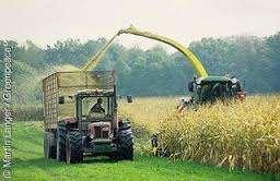
4 METHODS OF GEOGRAPHY MAPS: Maps: changing boundaries of a nation population density climate Vegetation agricultural products

5 World Population Density Map

6 Climate Map: Annual Avg. Temperature
7 World Vegetation Map
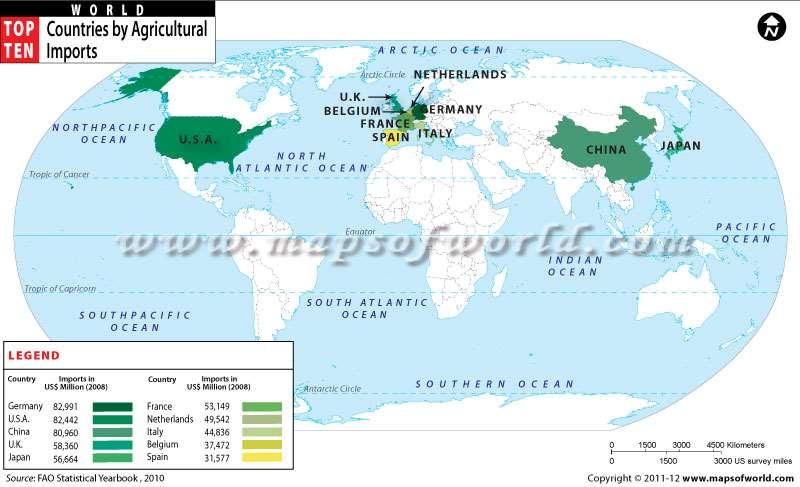
8 Agricultural Imports Map
9 METHODS OF GEOGRAPHY PHOTOGRAPHS: Gain visual evidence about a place CHARTS, GRAPHS, TABLES: Organize information, learn about patterns & understand changes 5 THEMES OF GEOGRAPHY:
10 Photographs

11 World Population Chart
12 5 THEMES OF GEOGRAPHY LOCATION Where is it? ABSOLUTE LOCATION: Lines of latitude are those that run parallel to the Equator (east to west). The Equator is a line of latitude that divides the earth into the northern and southern hemisphere. The equator is the starting point for lines of latitude with a designation of 0º latitude. Lines of latitude are called parallels.
13 5 THEMES OF GEOGRAPHY LOCATION Where is it? Lines of longitude are those that run north and south between the North and South poles. Lines of longitude are called: The Prime Meridian which runs through Greenwich, England has a:

14 THE GRID SYSTEM Rome, Italy is 41 N and its longitude is 12 E. The grid location of 41 N, 12 E will never change no matter what map you use. The grid system is made up of intersecting lines of latitude (parallels) and longitude (meridians).

15 HEMISPHERES Geographers also have divided the Earth into: Using the Equator, the Earth is divided into the: The Earth is also divided into the:

16 5 THEMES OF GEOGRAPHY LOCATION Where is it? Relative location: Compares location of one place to another in less precise terms. For example: New Orleans: 500 miles S of Memphis, 900 S of Chicago, etc.. * While a place can have only one absolute location:
17 5 THEMES OF GEOGRAPHY Place (What is it like?) The place s distinctive characteristics in both physical and human terms. Physical landforms (mountainous vs. level), ecosystems (vegetation or lack thereof), climate (weather patterns and extremes) Human:
18 5 THEMES OF GEOGRAPHY Region (How is one place different/similar to another?) A group of places w/: A region may be determined by people s:
19 5 THEMES OF GEOGRAPHY Region (How is one place different/similar to another?) Formal regions areas where a certain characteristic is found throughout. Such characteristics may be defined by man (ex: political boundaries) or by nature (ex: Corn Belt, California...). Functional regions a central place and surroundings affected by it (ex: Dallas-Fort Worth is a metropolitan area in which the two cities share an airport). Perceptual regions defined by people s attitudes and feelings about areas (what specific areas are considered part of Dixie?).

20 Perceptual Regions -"Political" Map
21 5 THEMES OF GEOGRAPHY Human-Environment Interaction (How do people relate to the physical world) Humans affect their environment: Changes can be : People living in similar environments do not respond to them in the same way People work to alter their environments to:
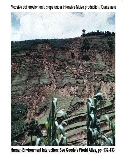
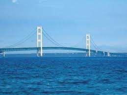
22 Human Environment Interaction
23 5 THEMES OF GEOGRAPHY Movement : - Movement can help to redefine a place. Ex: Immigration and Emigration rates for a country, imports vs. exports, media help to define movement.
24 5 THEMES OF GEOGRAPHY Movement (How do people, goods, and ideas move between places?) Linear Distance Time Distance Psychological Distance

25 Section 1.2: THE GEOGRAPHER S TOOLS GLOBE: Three dimensional representation of the earth. MAPS: Two dimensional: : CARTOGRAPHER: Mapmaker MAP PROJECTION: Way of drawing the earth s surface that:

26 TYPES OF MAPS General Reference Map Topographic Map

27 Thematic Maps TYPES OF MAPS

28 Science of Mapmaking Surveying Landsat Data used by cartographers to construct maps

29 GOES Satellites fly in orbit in synch with Earth s rotation. Always view the same area Gather images of:

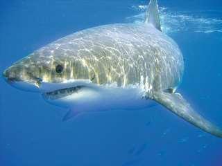
30 GPS Uses Navstars to tell: stalking-great-white-sharksinnovative-gps-taggingproject/story?id= #.uciw9tjaeta
31 CHAPTER 3 CLIMATE AND VEGETATION

32 Section 3.2: CLIMATE Wind Currents Hot air flows: Ocean Currents Warm water flows towards: Affect area s:


33 Zones of Latitude Low or : Middle or : High or : Elevation Distance: Air temp drops at : El Nino Every 2-7 years, winds push warm water and heavy rains towards : La Nina Reverse of El Nino, winds blow warmer water:


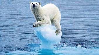
34 Climate Change Temperature : Increase in : Average rising temperatures Temps increased by: Predicted to rise : Greenhouse effect 08/starved-polar-bear-found-deadnorway-climatechange_n_ html
35

36 Global Climate Regions
37 World Vegetation Regions
Geography involves the study of places: their locations, their characteristics, and how humans use and move around them.
 Physical Geography Looking at the Earth Geography involves the study of places: their locations, their characteristics, and how humans use and move around them. NEXT Physical Geography Looking at the Earth
STUDY GUIDE. Exploring Geography. Chapter 1, Section 1. Terms to Know DRAWING FROM EXPERIENCE ORGANIZING YOUR THOUGHTS
 For use with textbook pages 19 22. Exploring Geography Terms to Know location A specific place on the earth (page 20) absolute location The exact spot at which a place is found on the globe (page 20) hemisphere
Unit 1 The Basics of Geography. Chapter 1 The Five Themes of Geography Page 5
 Unit 1 The Basics of Geography Chapter 1 The Five Themes of Geography Page 5 Geography comes from the Greek word geographia, which means to describe the earth. Geography is the study of the distribution
CHAPTER 1: EXPLORING GEOGRAPHY
 CHAPTER 1: EXPLORING GEOGRAPHY Please Do Now: In your PDN section of your binder answer the following with one or two sentences: What is Geography? What is Geography? The study of where people, places,
Map Skills and Geographic Tools
 Name: Period: Map Skills and Geographic Tools TEKS: 8.9C interpret topographic maps and satellite views to identify land and erosional features and predict how these features may be reshaped by weathering
Introduction to Geography
 Introduction to Geography What is geography? Geography comes from the Greek word Geographia. Geo means earth and graphia means to describe or chart. Geographers study the earth in relation to space and
Warmup. geography compass rose culture longitude
 Warmup geography compass rose culture longitude ecosystem latitude 1. study of the special physical and human characteristics of a place or region 2. learned system of shared beliefs, traits, and values
Exploring Geography. Chapter 1
 Exploring Geography Chapter 1 The Study of Geography Geography is the study of where people, places, and things are located and how they relate to each other. Greek meaning writing about or describing
Map Skills Unit. Note taking unit
 Map Skills Unit Note taking unit Introduction To learn about the Earth, we are going to learn about two geographic tools you can use.globes and maps. Globe A globe is a round model of the planet Earth
About places and/or important events Landmarks Maps How the land is, hills or flat or mountain range Connected to maps World Different countries
 What do you think you know about geography? About places and/or important events Landmarks Maps How the land is, hills or flat or mountain range Connected to maps World Different countries What do you
5 Themes of Geography Review Video Notes What is Geography?
 Name PG # 5 Themes of Geography Review Video Notes What is Geography? The study of, their, and their Main Idea or Topic Continents Notes about Main Idea or Topic There are 7 Continents or in the world:
VOCABULARY SCAVENGER HUNT Five Themes of Geography
 SECTION: VOCABULARY SCAVENGER HUNT Five Themes of Geography Directions: Skim The Five Themes of Geography and define the following words. Geography: Absolute Location: Relative Location: Hemisphere: Equator:
Texas Geography. Understanding the physical and human characteristics of our state
 Texas Geography Understanding the physical and human characteristics of our state To understand Texas you must first learn about its Geography. Geography- The study of the world, its people, and the interaction
1. Write down the term 2. Write down the book definition 3. Put the definition in your own words 4. Draw an image and/or put a Real Life Example
 Unit 1 Vocabulary 1. Write down the term 2. Write down the book definition 3. Put the definition in your own words 4. Draw an image and/or put a Real Life Example Absolute Location Where Is It EXACTLY?
What are Latitude and Longitude?
 What are Latitude and Longitude? By Encyclopaedia Britannica, adapted by Newsela staff on 08.29.17 Word Count 959 Level 950L A few miles from Quito, Ecuador's capital, is the equator line. It is located
The World of Geography Pre-Test/Study Guide Chapter 1 Test
 Read each statement or question. On the lines below write the letter of the best answer. 1. Geographers look at the Earth 5. What are the two specific A. by studying cities first. measurements of Earth
netw rks Guided Reading Activity Essential Question: How does geography influence the way people live? What Is Geography?
 Guided Reading Activity What Is Geography? Lesson 1 Thinking Like a Geographer Essential Question: How does geography influence the way people live? Directions: Read the lesson and use your textbook to
AP Human Geography Chapter 1: Thinking Geographically Key Issue 1: How do Geographers describe where things are?
 AP Human Geography Chapter 1: Thinking Geographically Key Issue 1: How do Geographers describe where things are? Studying Human Geography Physical Geography Physical geography deals with Earth s natural
What Is a Globe? Hemispheres. Main Idea Globes and maps provide different ways of showing features of the earth. Terms to Know
 r Main Idea Globes and maps provide different ways of showing features of the earth. Terms to Know hemisphere latitude longitude scale bar scale relief elevation contour line What Is a Globe? A globe is
MR. GOFF S WORLD HISTORY UNIT ONE: GEOGRAPHY 5 THEMES OF GEOGRAPHY
 MR. GOFF S WORLD HISTORY UNIT ONE: GEOGRAPHY 5 THEMES OF GEOGRAPHY BYOD BRING YOUR OWN DEVICE IN SMALL GROUPS (3-4), USE YOUR ELECTRONIC DEVICE(S) AND DEFINE THE FOLLOWING VOCAB. WORDS 1. GEOGRAPHY 2.
... Europe. Based on Bloom s Taxonomy. Environment Interactions Movement. Human & Location. Regions. Place
 ... Europe Location Place Human & Environment Interactions Movement Regions LEVEL 1 Knowledge Match Show or Label List Information Recall Details (5Ws + H) Find Information LEVEL 2 Comprehension Describe
Word Cards. 2 map. 1 geographic representation. a description or portrayal of the Earth or parts of the Earth. a visual representation of an area
 Name: Date: Hour: Word Cards 1 geographic representation a description or portrayal of the Earth or parts of the Earth Example: A map is a representation of an actual location or place. 2 map a visual
Key Issue #1. How do geographers describe where things are? 2014 Pearson Education, Inc.
 Key Issue #1 How do geographers describe where things are? Learning Outcomes 1.1.1: Explain differences between early maps and contemporary maps. 1.1.2: Describe the role of map scale and projections and
Mapping Earth. How are Earth s surface features measured and modeled?
 Name Mapping Earth How are Earth s surface features measured and modeled? Before You Read Before you read the chapter, think about what you know about maps Record your thoughts in the first column Pair
Mapping Earth s Surface Chapter 2 Section 3
 Mapping Earth s Surface Chapter 2 Section 3 Day 1 Objective I will understand maps can be used to find locations on Earth and to represent information about features on Earth s Surface I will understand
Introduction to Geography
 Introduction to Geography ropic of Cancer 3½ N Arctic Circle 90 N Prime Meridian 0 Arctic Ocean Mississippi R. Appalachian Mts. Europe Rocky Mountains N. America Atlantic Gulf of Ocean Mexico Caribbean
What is Geography? Lecture 1 The Earth As A Rotating Planet. What is Geography? What is geography? Subfields of Geography?
 Lecture 1 The Earth As A Rotating Planet Geog210 Physical Geography What is Geography? Much more than place names and locations The study of spatial variation How and why things differ from place to place
Using Maps. Using Maps. Using Maps. Using Maps
 A is a visual representation, or model, of part or all of the earth. lines are imaginary lines that run east to west around the globe; they are also known as parallels. They show distances in degrees north
What is a map? A Map is a two or three-dimensional model or representation of the Earth s surface. 2-Dimensional map
 What is a map? A Map is a two or three-dimensional model or representation of the Earth s surface. 2-Dimensional map What is a Map Projection? Planar Projection Projection A Projection is a mathematical
Module 2: Mapping Topic 2 Content: Determining Latitude and Longitude Notes
 Introduction In order to more easily locate points on a globe or map, cartographers designed a system of imaginary vertical lines (also called parallels) and horizontal lines (also called meridians) that
GEOGRAPHY POLICY STATEMENT. The study of geography helps our pupils to make sense of the world around them.
 GEOGRAPHY POLICY STATEMENT We believe that the study of geography is concerned with people, place, space and the environment and explores the relationships between the earth and its peoples. The study
Advanced World Geography Chapter 01 Exploring Geography
 Advanced World Geography Chapter 01 Exploring Geography Lesson 1 Study of Geography In this lesson you will learn how to: tell what geography is and what geographic tools are used. tell what the various
Chapter 1: The World of Geography
 Chapter 1: The World of Geography Chapter 1: What is Geography? *It is the study of our earth; our home. OR *Anything that can be mapped! *Geography mixes up the physical and human aspects of our world
Global Weather Trade Winds etc.notebook February 17, 2017
 Global Weather 1 north pole northern hemisphere equator southern hemisphere south pole 2 We have seasons because of the Earth's tilt The seasons are opposite in the northern and southern hemispheres winter
How Geographers View the World: Human Geography. ESSENTIAL QUESTION: How does geography influence the way people live?
 How Geographers View the World: Human Geography ESSENTIAL QUESTION: How does geography influence the way people live? Geographers Think Spatially Gefffffdgfhfjgjp Guiding Question: What does it mean to
What do we call someone who makes maps? CARTOGRAPHER
 What do we call someone who makes maps? CARTOGRAPHER 1 Maps Political Maps - show boundaries of states, countries, counties, etc... - These are man made boundaries Physical Maps - show landforms (volcanoes,
Complete the following: a. Lines of latitude are parallel to the equator. Name:
 Name: Date: Social Studies Introduction: Basic Geography Period: Latitude Latitude is defined as a measurement of distance in degrees north and south of the equator. The word latitude is derived from the
Five Themes of Geography. By PresenterMed
 Five Themes of Geography By PresenterMed Geography Geography: the study of the Earth Where are things located? Why are they there? Location Location: where a place is Cardinal Directions: North, South,
Latitude and Longitude
 Latitude and Longitude Finding Your Location on a Sphere Coordinate Systems n When you are locating a point on a flat surface you can use Cartesian coordinates of x and y. n The point 2, 3 is plotted on
4th Grade US Regional Geography First Nine Weeks
 4th Grade US Regional Geography First Nine Weeks 2014-2015 Identify the choice that best completes the statement or answers the question. 1 The line identified as 0 runs west and east on the globe and
Different types of maps and how to read them.
 Different types of maps and how to read them. A map is a picture or representation of the Earth's surface, showing how things are related to each other by distance, direction, and size. Maps have been
Map Skills Test. 1. What do we call a person who makes maps? a. mapographer b. cartographer c. geologist d. archaeologist
 Map Skills Test 1. What do we call a person who makes maps? a. mapographer b. cartographer c. geologist d. archaeologist 2. What is the name of the 0 latitude line? a. Equator b. Arctic Circle c. First
Investigation 11.3 Weather Maps
 Name: Date: Investigation 11.3 Weather Maps What can you identify weather patterns based on information read on a weather map? There have been some amazing technological advancements in the gathering and
Year 1 name and locate the four countries and capital cities of the United Kingdom and its surrounding seas
 Long Term Objective Organisation for Geography Please note that only statutory requirements should be included in this document; any supplementary guidance and information should be retained by Subject
Chapter 3 Models of the Earth. 3.1 Finding Locations on the Earth. 3.1 Objectives
 Chapter 3 Models of the Earth 3.1 Finding Locations on the Earth 3.1 Objectives Explain latitude and longitude. How can latitude and longitude be used to find locations on Earth? How can a magnetic compass
Latitude and Longitude Pre Test
 Name Date Latitude and Longitude Pre Test Multiple Choice Directions: For questions, 1 10 circle the answer that letter that best answers the question. Each question is worth 1 point each. 1. To locate
name and locate the world s seven continents and five oceans
 Subject: Geography Activities National Curriculum Objectives One Progression of Skills Name the 7 continents and 5 oceans 3D Jigsaw task to locate continents and seas name and locate the world s seven
page - 1 Laboratory Exercise #1 - Introduction to Latitude and Longitude Northern Hemisphere Southern Hemisphere
 page - 1 Laboratory Exercise #1 - Introduction to Latitude and Longitude A. Introduction There are many methods that can be used to locate ones position on the surface of the earth. A common method for
Geography Mile Post 1
 Mile Post 1 Use world maps, atlases and globes to identify the UK and its countries, as well as the countries, continents and oceans studied at this key stage Key Skills IPC learning Goals 1.11 Be able
Maps and Globes. By Kennedy s Korner
 Maps and Globes By Kennedy s Korner Map Key or Symbols Maps use symbols to show places and things on Earth. Symbols are drawings that stand for something real. A map key tells you what each symbol stands
Unit 1: Basics of Geography Test Review
 Name Date Period Unit 1: Basics of Geography Test Review Directions: Reading the following sections and complete the questions, charts, and diagrams. Types of Maps Maps that have a particular theme are
Name: Climate Date: EI Niño Conditions
 Name: Date: Base your answers to questions 1 and 2 on the maps and the passage below. The maps show differences in trade wind strength, ocean current direction, and water temperature associated with air-pressure
Geography Route Planner
 Geography Route Planner Introduction to Route Planners Route Planners outline the Key Stages 1-3 curriculum to be taught within each campus of the Bury St Edmunds Trust. Each Route Planner has been designed
Complete Geography Overview: Year 1 to Year 6
 Option 1 Complete Geography Overview: Year 1 to Year 6 Autumn Term Spring Term Summer Term Year 1 Where do I live? Around the World The Four Seasons Year 2 At the Farm Let s go on Safari My World and Me
Standard Indicator That s the Latitude! Students will use latitude and longitude to locate places in Indiana and other parts of the world.
 Standard Indicator 4.3.1 That s the Latitude! Purpose Students will use latitude and longitude to locate places in Indiana and other parts of the world. Materials For the teacher: graph paper, globe showing
Mapping Our World Chapter 2
 Mapping Our World Chapter 2 Section 2.1: Latitude and Longitude Maps are flat models of threedimensional objects. For thousands of years people have used maps to define borders and to find places. With
New National Curriculum Geography Skills Planning KS1
 New National Curriculum Geography Skills Planning KS1 Enquiry Question Objective-essential knowledge skills or understanding Locational Knowledge Standards /Success Criteria Lesson progression over half
Map Making. Chapter 2 Section 1
 Map Making Chapter 2 Section 1 Latitude and Longitude Objectives Compare and contrast latitude and longitude. Describe how time zones vary. Vocabulary cartography equator latitude longitude prime meridian
Chapter 1 Section 2. Land, Water, and Climate
 Chapter 1 Section 2 Land, Water, and Climate Vocabulary 1. Landforms- natural features of the Earth s land surface 2. Elevation- height above sea level 3. Relief- changes in height 4. Core- most inner
Geographers Tools: Location Systems Prof. Anthony Grande Hunter College Geography
 5 Geographers Tools: Location Systems Prof. Anthony Grande Hunter College Geography Lecture design, content and presentation AFG 0119 Individual images and illustrations may be subject to prior copyright.
Stamp Area. Earth Science - Note Packet #6. The shape of the Earth. The Earth is in shape.
 Name: Earth Science - Note Packet #6 Mr. LaFranca s - Period Date: Aim: What are Latitude and Longitude? Do Now: Using the map, where is this location? Stamp Area X The shape of the Earth The Earth is
Geography Long Term Plan. Autumn Spring Summer
 Geography Long Term Plan Autumn Spring Summer Year 1 Working Scientifically covered throughout the year Location Geography of UK Name, locate and identify characteristics of the four countries and capital
Cardinal and Intermediate Directions:
 Name Period Parent Signature Due Date: (TBA) Geography/Map Skills Study Guide Continents and Oceans of the World: Label the continents (7) and oceans (4) on the lines below the map. 1 11 3 5 4 8 2 9 10
Warm up: (8 min) Use the Map, On the Prom (Color) Paper (Blk/White) and answer the questions on your paper
 Use the Map, On the Prom (Color) Paper (Blk/White) and answer the questions on your paper") Warm up: (8 min) Use the Map, On the Prom (Color) Paper (Blk/White) and answer the questions on your paper TX History: Mapping and Geography of Texas: We will discuss some slides and write notes on others
Warm up: (8 min) Use the Map, On the Prom (Color) Paper (Blk/White) and answer the questions on your paper TX History: Mapping and Geography of Texas: We will discuss some slides and write notes on others
Chapter 2 - Lessons 1 & 2 Studying Geography, Economics
 Chapter 2 - Lessons 1 & 2 Studying Geography, Economics How does geography influence the way people live? Why do people trade? Why do people form governments? Lesson 1 - How Does Geography Influence the
Location/Distance Geographers Coordinate use system these to establish location Parallels and distance:
 A Little More Stuff Remote Sensing- Acquisition of data about the earth s surface using satellites and other long range methods Global Information System (GIS)-Computer system that stores, organizes, and
Geography 101: The Basics
 Geography 101: The Basics What is Geography? Geography is the study of the HUMAN and NON- HUMAN features of the Earth.! Geographers study where things are located why they are located in a specific place.!
World Geography TEKS 2nd Nine Weeks. Unit of Study Regional Studies; U.S. and Canada Regional Studies; Latin America; and Europe
 World Geography TEKS 2nd Nine Weeks Unit of Study Regional Studies; U.S. and Canada Regional Studies; Latin America; and Europe 1) History. The student understands how geography and processes of spatial
THE FIVE THEMES OF GEOGRAPHY U N I T O N E
 THE FIVE THEMES OF GEOGRAPHY U N I T O N E FIVE THEMES OF GEOGRAPHY 1. Location 2. Place 3. Human-Environment Interaction 4. Movement 5. Region LOCATION LOCATION The position that something occupies Earth
Chapter 2: Studying Geography, Economics, and Citizenship
 Chapter 2: Studying Geography, Economics, and Citizenship Lesson 2.1 Studying Geography I. Displaying the Earth s Surface A. A globe of the Earth best shows the sizes of continents and the shapes of landmasses
The Geography Curriculum at Coston Primary
 The Geography Curriculum at Coston Primary Years Year 1 Year 2 Summer We are learning about where food is farmed and in The physical features of farms. The human features of farms. The characteristics
World Geography. Teacher s Guide
 World Geography Teacher s Guide WALCH PUBLISHING Table of Contents To the Teacher.......................................................... vi Classroom Management.................................................
What is Geography? *Mixes up the physical and human aspects of our world into one field of study.
 World Geography What is Geography? *It is the study of the earth *Mixes up the physical and human aspects of our world into one field of study. *Shows the relationship between people and the environment.
Tuition, Medical and Behaviour Support Service
 Tuition, Medical and Behaviour Support Service Curriculum Policy - Primary Geography Reviewed: October 2018 Next Review: October 2019 Responsibility: Andrea Snow AIMS AND PRINCIPLES The national curriculum
Geography Test Unit 1 Study Guide. democracy profit citizenship Bill of Rights consumers federal government political process values
 Geography Test Unit 1 Study Guide Skills Identify Longitude and Latitude Identify Continents of the World Identify Time Zones Equator Prime Meridian Hemispheres Map Requirements Oceans Compare US/Mexico/Canada
Chapter 02 Maps. Multiple Choice Questions
 Chapter 02 Maps Multiple Choice Questions 1. Every projection has some degree of distortion because A. a curved surface cannot be represented on a flat surface without distortion. B. parallels and meridians
THE EARTH AND ITS REPRESENTATION
 UNIT 7 THE EARTH AND ITS REPRESENTATION TABLE OF CONTENTS 1 THE EARTH AND THE SOLAR SYSTEM... 2 2 THE EARTH S MOVEMENTS... 2 2.1 Rotation.... 2 2.2 The revolution of the Earth: seasons of the year....
Chapter 3 SECTION 1 OBJECTIVES
 Chapter 3 SECTION 1 OBJECTIVES Distinguish between latitude and longitude and locate coordinates on maps. Explain how latitude and longitude can be used to locate places on Earth s surface. Explain the
Geography. Programmes of study for Key Stages 1-3
 Geography Programmes of study for Key Stages 1-3 February 2013 Contents Purpose of study 3 Aims 3 Attainment targets 3 Subject content 4 Key Stage 1 4 Key Stage 2 5 Key Stage 3 6 2 Purpose of study A high-quality
Some of these parallels are very important. In the Northern Hemisphere, there is the Tropic of Cancer and the Arctic Circle.
 PDF 2 Geographic coordinates 1 The geographic coordinates system is network of imaginary horizontal and vertical lines that are drawn on globes or maps. These lines are called parallels (lines of latitude)
CHAPTER EXIT CHAPTER. Models of Earth. 3.1 Modeling the Planet. 3.2 Mapmaking and Technology. 3.3 Topographic Maps CHAPTER OUTLINE
 EXIT CHAPTER.1 Modeling the Planet.2 Mapmaking and Technology. Topographic Maps CHAPTER OUTLINE CHAPTER.1 Modeling the Planet A flat of Earth is a convenient tool, but it can distort the shape, distance,
Chapter 1: Basic Concepts
 Chapter 1: Basic Concepts The Cultural Landscape: An Introduction to Human Geography Defining Geography Word coined by Eratosthenes Geo = Earth Graphia = writing Geography thus means earth writing Contemporary
Dr. M.K.K. Arya Model School Class-V, Social Science Assignment Ch-1, Globe The Model of the Earth Answer the following:- Q.1.
 Class-V, Social Science Assignment Ch-1, Globe The Model of the Earth - Q.1. What are the disadvantages/demerits of a globe? Ans. Some disadvantages of globe are: a) It is difficult to carry. b) It cannot
Map Skills Lesson 1. Materials: maps, pencils, Lesson 1 Worksheet, strips of paper, grid paper
 Map Skills Lesson 1 Use cardinal directions, map grids, scales, and titles to locate places on a map. Interpret a map using information from its title, compass rose, scale, and legend. Vocabulary: map,
Chapter 1 Introduction to the Earth
 Chapter 1 Introduction to the Earth What is Geography? The study of the earth as the home of humankind. Greek - Eratosthenes Father of Geography Geo means Earth Graphy means to write Study how things are
World Geography Chapter 3
 World Geography Chapter 3 Section 1 A. Introduction a. Weather b. Climate c. Both weather and climate are influenced by i. direct sunlight. ii. iii. iv. the features of the earth s surface. B. The Greenhouse
3) What is the difference between latitude and longitude and what is their affect on local and world weather and climate?
 What is the difference between latitude and longitude and what is their affect on local and world weather and climate?") www.discoveryeducation.com 1) Describe the difference between climate and weather citing an example of each. Describe how water (ocean, lake, river) has a local effect on weather and climate and provide
www.discoveryeducation.com 1) Describe the difference between climate and weather citing an example of each. Describe how water (ocean, lake, river) has a local effect on weather and climate and provide
2. Environmental issues in the relationship of humankind to the environment
 Course Goals to Understand 1. Processes operating on the earth s surface Atmosphere Lithosphere Hydrosphere Biosphere 2. Environmental issues in the relationship of humankind to the environment 3. Science
Witchampton CofE First School Geography Curriculum Map
 2016-2017 Autumn People and : 30-50 Show interest in the lives of people who are familiar to them. Shows interest in different occupations. Remembers and talks significant events in their own experience.
Latitude and Longitude. Finding your location throughout the world!
 Latitude and Longitude Finding your location throughout the world! What is Latitude? Latitude is defined as a measurement of distance in degrees north and south of the equator The word latitude is derived
Geography Progression
 Geography Progression This document aims to track expectations for History within George Grenville Academy. What the National Curriculum says: KS1: Locational Knowledge: Name and locate the world s 7 continents
Unit 1 Part 2. Concepts Underlying The Geographic Perspective
 Unit 1 Part 2 Concepts Underlying The Geographic Perspective Unit Expectations 1.B Enduring Understanding: Students will be able to.. Know that Geography offers asset of concepts, skills, and tools that
SOCIAL STUDIES GRADE 5. I Can Checklist Office of Teaching and Learning Curriculum Division REGIONS AND PEOPLE OF THE WESTERN HEMISPHERE
 SOCIAL STUDIES REGIONS AND PEOPLE OF THE WESTERN HEMISPHERE GRADE 5 I Can Checklist 2015-2016 Aligned with Ohio s Learning Standards for Social Studies Office of Teaching and Learning Curriculum Division
Geography Skills Progression Key Stage 2
 Year 3 Year 4 Year 5 Year 6 Expectations at end of key stage Location knowledge the countries of Europe? countries in Europe, environmental regions? countries in Europe, key physical and human characteristics?
A. Spatial Sense (Working with Maps, Globes, and Other Geographic Tools)
") A. Spatial Sense (Working with Maps, Globes, and Other Geographic Tools) Measuring Distance Using Map Scale All maps are drawn to scale; that is, they are smaller than the things they represent. Scale
A. Spatial Sense (Working with Maps, Globes, and Other Geographic Tools) Measuring Distance Using Map Scale All maps are drawn to scale; that is, they are smaller than the things they represent. Scale
Five Themes of Geography. EG.5.J.a - Use and evaluate geographic research sources to interpret Earth's physical and human systems.
 Five Themes of Geography EG.5.J.a - Use and evaluate geographic research sources to interpret Earth's physical and human systems. What is Geography? Geography is the study of the earth and of the ways
Map Master Skills Handbook
 1 Map Master Skills Handbook Five Themes of Geography Understanding Globes How To Use A Map Human Migration Notebook Number Mr. Graver Old World Cultures Name Period 2 In this chapter, you ll be introduced
World Geography Mid Term Review 2016
 World Geography Mid Term Review 2016 1.Latitude and Longitude Lines of latitude run and. The zero-degree line is the. Line of longitude run and. The zero degree line is called the. 2. Map Projections What
SOCIAL STUDIES GRADE 6. I Can Checklist REGIONS AND PEOPLE OF THE EASTERN HEMISPHERE. Office of Teaching and Learning Curriculum Division
 SOCIAL STUDIES REGIONS AND PEOPLE OF THE EASTERN HEMISPHERE GRADE 6 I Can Checklist 2018-2019 Aligned with Ohio s Learning Standards for Social Studies Office of Teaching and Learning Curriculum Division
Chapter One. Thinking Geographically
 Chapter One Thinking Geographically Where are you? Tell me where you are. How do you know? Important Terms Map two dimensional or flat scale model of the Earth. Place A specific Point on the Earth s surface.