Road Safety Risk Model for Low Volume Rural Networks
|
|
|
- Dinah Clara Horn
- 6 years ago
- Views:
Transcription


1 Road Safety Risk Model for Low Volume Rural Networks Paul Durdin Dale Harris TrafiNZ Conference 2015 Transport Futures: The Changing Face of Transport


2 Safe System Signature Projects


3 Context Eastern Bay of Plenty Signature Project


4 Risk Prediction - EBoP 57.9% of rural crashes occur on curves Low volume road network (1500 km) Traditional risk assessment using crash history unreliable A new methodology is required


5 Austroads Operating Speed Model Uses road geometry to estimate 85 th percentile vehicle operating speeds by modelling: acceleration on long straights deceleration on curves Also identifies curve risk (desirable, undesirable, unacceptable)

6 A GIS Approach Input: high quality road centreline
7 A GIS Approach Divide centreline into 10m sections Calculate rolling average 30m radius Curve Identification 30m 10m Combine 10m segments where: radius <= 500m and curve direction does not change

8 A GIS Approach Curve Identification R=45m Illustration R=28m R=99m R=33m R=41m R=22m R=30m R=24m

9 A GIS approach - Identify Operating Speed Sections
 Mountainous (>=8%) Curvature Straight 110 km/h 110 km/h 95 km/h 90 km/h Curved")
 speed derived as a function of curvature and")
10 A GIS Approach Identify Maximum Speeds Terrain (and grade %) Flat (<2%) Undulating (2-4%) Hilly (5-7%) Mountainous (>=8%) Curvature Straight 110 km/h 110 km/h 95 km/h 90 km/h Curved 110 km/h 100 km/h 95 km/h 90 km/h Winding 90 km/h 90 km/h 85 km/h 80 km/h Tortuous 75 km/h 75 km/h 75 km/h 70 km/h Maximum (desired) speed derived as a function of curvature and terrain


11 A GIS approach calculate operating speeds Speeds modelled in both directions

 Desirable")


12 Austroads Curve Context Definitions Within context: No limit (no deceleration) Desirable (some deceleration) Out-of-context: Undesirable Unacceptable Exit speed Approach speed Curve radius
13 Calibration against State Highway Data

14 SignatureNET: High Risk Curve Identification
15 SignatureNET: High Risk Curve Identification
16 SignatureNET: High Risk Curve Identification

17 SignatureNET: High Risk Curve Identification
18 Safety of Out-of-Context Curves 6,985 curves identified 66.6% of loss of control crashes occurred on the 20.3% of curves classified as unacceptable or undesirable
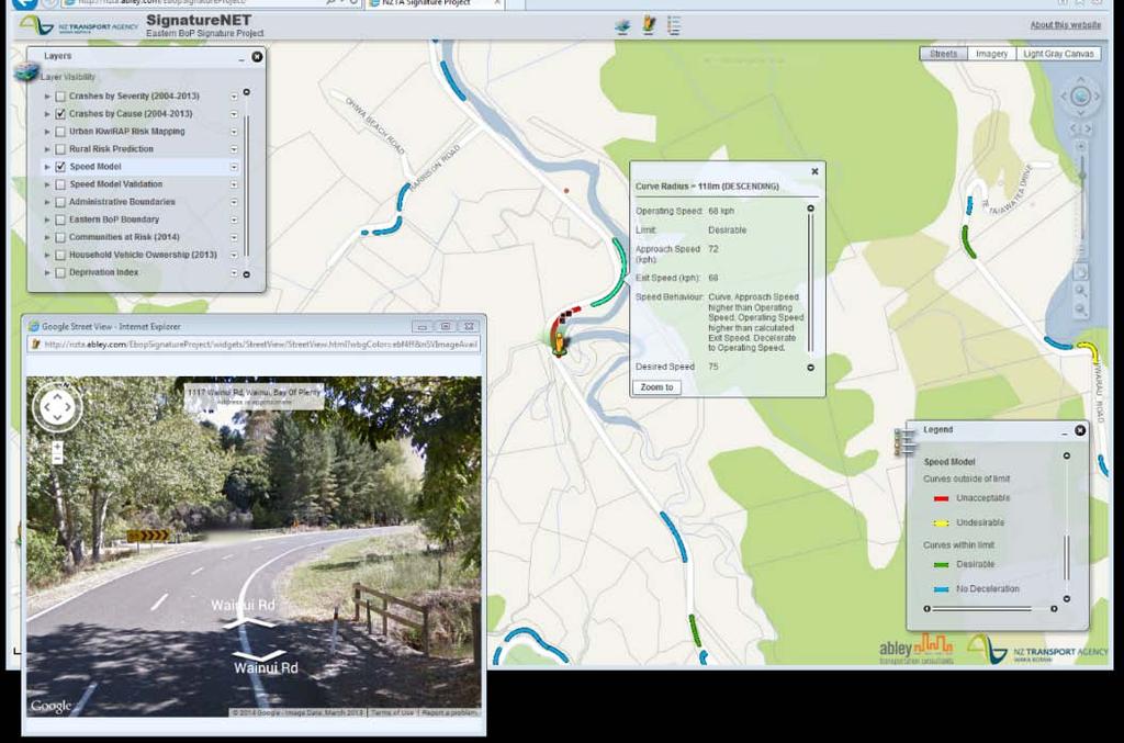
19 SignatureNET web viewer

20 Further Analysis and Validation of the Speed Model Applied to the Top of the South network (Marlborough, Nelson & Tasman) 3,382 km of rural roads compared to ~1,500 km in the Eastern Bay of Plenty 21,158 curves in the Top of the South region 18.9% of curves classified as unacceptable or undesirable 55.8% of loss of control crashes on these curves

21 Applications of the Speed Model Exploring the potential road safety benefits of speed management Intrinsic link between speed and crash outcomes Nilsson s Power Model Informs the speed management response and priority for intervention.
22 Key Points Supports prioritisation of targeted road safety interventions SignatureNET as single source of road safety information for all project partners Demonstrates innovation within a safe systems project

23 Key Points Network screening tool developed specifically for lowvolume rural networks. Identifies curves by targeting to risk = proactive Assists Road Controlling Authorities make informed decisions about road safety.
3 377 4703 +64(0)3 377 4700 W www.abley.")
24 Paul Durdin T M E Paul.durdin@abley.com Contact the office T M +64(0) (0) W Auckland Level 8, 57 Fort Street P O Box Auckland 1142 New Zealand Christchurch Level 1 and 2, 30a Carlyle Street. PO Box 25350, Christchurch 8144 New Zealand
Geospatial Big Data Analytics for Road Network Safety Management
 Proceedings of the 2018 World Transport Convention Beijing, China, June 18-21, 2018 Geospatial Big Data Analytics for Road Network Safety Management ABSTRACT Wei Liu GHD Level 1, 103 Tristram Street, Hamilton,
ENHANCING ROAD SAFETY MANAGEMENT WITH GIS MAPPING AND GEOSPATIAL DATABASE
 Abstract ENHANCING ROAD SAFETY MANAGEMENT WITH GIS MAPPING AND GEOSPATIAL DATABASE Dr Wei Liu GHD Reliable and accurate data are needed in each stage of road safety management in order to correctly identify
TECHNICAL NOTE PREDICTION OF PAVEMENT SURFACE SKID RESISTANCE AND THE EFFECT OF SMALLER CHIP SIZE
 TECHNICAL NOTE PREDICTION OF PAVEMENT SURFACE SKID RESISTANCE AND THE EFFECT OF SMALLER CHIP SIZE Authors: Birendra Kumar, MEngSt(Transportation), Bachelor(Civil), GIPENZ Senior Transportation Engineer
FHWA GIS Outreach Activities. Loveland, Colorado April 17, 2012
 FHWA GIS Outreach Activities Loveland, Colorado April 17, 2012 GIS for Improved Decision Making FHWA believes that geographic information systems and other geospatial technologies (remote sensing and GPS)
Local Calibration Factors for Implementing the Highway Safety Manual in Maine
 Local Calibration Factors for Implementing the Highway Safety Manual in Maine 2017 Northeast Transportation Safety Conference Cromwell, Connecticut October 24-25, 2017 MAINE Darryl Belz, P.E. Maine Department
Accident benefits of sealing unsealed roads February Land Transport New Zealand Research Report 314
 Accident benefits of sealing unsealed roads February 2007 Land Transport New Zealand Research Report 314 Accident benefits of sealing unsealed roads J. Minchington and P. Bradshaw Beca Infrastructure
How GIS Can Help With Tribal Safety Planning
 How GIS Can Help With Tribal Safety Planning Thomas A. Horan, PhD Brian Hilton, PhD Arman Majidi, MAIS Center for Information Systems and Technology Claremont Graduate University Goals & Objectives This
Vehicle Motion Equations:
 1 Vehicle Motion Equations: v = at + v (2.2.4) x x = v2 2 v 2a (2.2.6) v 2 = v 2 + 2a(x x ) (2.2.6) x = 1 2 at2 + v t + x (2.2.7) D b = x cos α (2.2.10) x = vt D b = v 2 v 2 2g(f G) (2.2.14) e + f s =
Lessons learnt using GIS to map geological hazards following the Christchurch earthquake
 Gerrard, L.C, Herbert J.A & Revell T.A.J (2013) Proc. 19 th NZGS Geotechnical Symposium. Ed. CY Chin, Queenstown Lessons learnt using GIS to map geological hazards following the Christchurch earthquake
Warning Timing, Driver Distraction, and Driver Response to Imminent Rear-End Collisions
 AEBS/LDWS-06-08 Warning Timing, Driver Distraction, and Driver Response to Imminent Rear-End Collisions review of some research literature referred to in the ITS guidelines for high-priority warnings 1
Revision checklist. Step Learning outcome Had a look Nearly there Nailed it!
 Motion and Forces a Resultant forces Step Learning outcome Had a look Nearly there Nailed it Explain the difference between scalar and vector quantities. Use arrows to represent the direction and magnitude
Cost-Benefit Analysis of the Pooled- Fund Maintenance Decision Support System: Case Study
 Cost-Benefit Analysis of the Pooled- Fund Maintenance Decision Support System: Case Study Zhirui Ye (WTI) Xianming Shi (WTI) Christopher K. Strong (City of Oshkosh) 12 th AASHTO-TRB TRB Maintenance Management
GIS ANALYSIS METHODOLOGY
 GIS ANALYSIS METHODOLOGY No longer the exclusive domain of cartographers, computer-assisted drawing technicians, mainframes, and workstations, geographic information system (GIS) mapping has migrated to
Comparison of spatial methods for measuring road accident hotspots : a case study of London
 Journal of Maps ISSN: (Print) 1744-5647 (Online) Journal homepage: http://www.tandfonline.com/loi/tjom20 Comparison of spatial methods for measuring road accident hotspots : a case study of London Tessa
Factors Affecting the Severity of Injuries Sustained in Collisions with Roadside Objects
 Factors Affecting the Severity of Injuries Sustained in Collisions with Roadside Objects Presenter: Ashirwad Barnwal Adviser: Dr. Peter T. Savolainen Source: clipartbest.com 1 Overview Background Research
Health GIS Tools and Applications Informing Decisions in Yemen
 Health GIS Tools and Applications Informing Decisions in Yemen Prepared by: Carleen Ghio 1, Mark Landry 1, Abdulkadir Nueman 2, and Ahmed Attieg 3 Presented at: Map Middle East Conference April 23-25,
Road Network Impedance Factor Modelling Based on Slope and Curvature of the Road
 Cloud Publications International Journal of Advanced Remote Sensing and GIS 2017, Volume 6, Issue 1, pp. 2274-2280 ISSN 2320 0243, Crossref: 10.23953/cloud.ijarsg.289 Methodology Article Road Network Impedance
Spatial Variation in Local Road Pedestrian and Bicycle Crashes
 2015 Esri International User Conference July 20 24, 2015 San Diego, California Spatial Variation in Local Road Pedestrian and Bicycle Crashes Musinguzi, Abram, Graduate Research Assistant Chimba,Deo, PhD.,
Applying Health Outcome Data to Improve Health Equity
 Applying Health Outcome Data to Improve Health Equity Devon Williford, MPH, Health GIS Specialist Lorraine Dixon-Jones, Policy Analyst CDPHE Health Equity and Environmental Justice Collaborative Mile High
Road Weather Management Program
 Road Weather Management Program AASHTO/TRB Joint Maintenance Conference: Highway Safety & Reliability (Winter Maintenance and Highway Safety and Reliability) 7/22/2015 Gabe Guevara. P.E. FHWA Office of
Coastal Hazard and Climate-Change Risk Exposure in New Zealand: Comparing Regions and Urban Areas
 Presented at the FIG Working Week 2016, May 2-6, 2016 in Christchurch, New Zealand Coastal Hazard and Climate-Change Risk Exposure in New Zealand: Comparing Regions and Urban Areas Rob Bell, Ryan Paulik
Using a K-Means Clustering Algorithm to Examine Patterns of Vehicle Crashes in Before-After Analysis
 Modern Applied Science; Vol. 7, No. 10; 2013 ISSN 1913-1844 E-ISSN 1913-1852 Published by Canadian Center of Science and Education Using a K-Means Clustering Algorithm to Examine Patterns of Vehicle Crashes
Location Suitability Analysis
 2010 Fall 406 Final Project Location Suitability Analysis New Burger stores in San Fernando Valley Presenter: Rich Lee I. Introduction In-N-Out Burger is famous in South West America. Established in 1948
an expression, in terms of t, for the distance of the particle from O at time [3]
![an expression, in terms of t, for the distance of the particle from O at time [3]](/thumbs/88/114967411.jpg "an expression, in terms of t, for the distance of the particle from O at time [3]") HORIZON EDUCATION SINGAPORE Additional Mathematics Practice Questions: Kinematics Set 1 1 A particle moves in a straight line so that t seconds after passing through O, its velocity v cm s -1, is given
HORIZON EDUCATION SINGAPORE Additional Mathematics Practice Questions: Kinematics Set 1 1 A particle moves in a straight line so that t seconds after passing through O, its velocity v cm s -1, is given
Town of Bowden Province of Alberta Policy Document ( ) SNOW REMOVAL POLICY
 SNOW REMOVAL POLICY") Town of Bowden Box 338, 2101 20 th Ave Bowden, Alberta, T0M 0K0 Town of Bowden Province of Alberta Policy Document (2019-01) SNOW REMOVAL POLICY 1 INTRODUCTION The purpose of this policy is to establish
Town of Bowden Box 338, 2101 20 th Ave Bowden, Alberta, T0M 0K0 Town of Bowden Province of Alberta Policy Document (2019-01) SNOW REMOVAL POLICY 1 INTRODUCTION The purpose of this policy is to establish
DEVELOPMENT OF CRASH PREDICTION MODEL USING MULTIPLE REGRESSION ANALYSIS Harshit Gupta 1, Dr. Siddhartha Rokade 2 1
 DEVELOPMENT OF CRASH PREDICTION MODEL USING MULTIPLE REGRESSION ANALYSIS Harshit Gupta 1, Dr. Siddhartha Rokade 2 1 PG Student, 2 Assistant Professor, Department of Civil Engineering, Maulana Azad National
UNIVERSITY OF NAIROBI
 UNIVERSITY OF NAIROBI SITE SUITABILITY ANALYSIS FOR RESIDENTIAL DEVELOPMENTS A case study of Langata Constituency, Nairobi Kenya Presented By Kevin Otiego Supervisor: Mr. Samuel Nthuni Department of Geospatial
Perth County Road Fatal Head-on Collision - A Common and Dangerous Issue
 Perth County Road Fatal Head-on Collision - A Common and Dangerous Issue Posting Date: 25-Aug-2016 Figure 1: View looking east long "Speeders Alley" - a more appropriate name for the long, straight and
Percentage of normal rainfall for August 2017 Departure from average air temperature for August 2017
 New Zealand Climate Update No 219, August 2017 Current climate August 2017 Overall, mean sea level pressure was lower than normal over and to the west of New Zealand during August while higher than normal
w = mg Use: g = 10 m/s 2 1 hour = 60 min = 3600 sec
 The exam is closed book and closed notes. Part I: There are 1 multiple choice questions, 1 point each. The answers for the multiple choice questions are to be placed on the SCANTRON form provided. Make
FHWA Road Weather Management Program Update
 FHWA Road Weather Management Program Update 2015 Winter Maintenance Peer Exchange Bloomington, MN September 21-25, 2015 Gabe Guevara FHWA Office of Operations Road Weather Management Team 2015 Winter Maintenance
Created by T. Madas CALCULUS KINEMATICS. Created by T. Madas
 CALCULUS KINEMATICS CALCULUS KINEMATICS IN SCALAR FORM Question (**) A particle P is moving on the x axis and its acceleration a ms, t seconds after a given instant, is given by a = 6t 8, t 0. The particle
INSPIRE in the context of EC Directive 2002/49/EC on Environmental Noise
 INSPIRE in the context of EC Directive 2002/49/EC on Environmental Noise Simon Shilton Acustica Ltd, United Kingdom Nigel Jones Extrium Ltd, United Kingdom About the Authors www.acustica.co.uk Acoustics
Implication of GIS Technology in Accident Research in Bangladesh
 Journal of Bangladesh Institute of Planners ISSN 2075-9363 Vol. 8, 2015 (Printed in December 2016), pp. 159-166, Bangladesh Institute of Planners Implication of GIS Technology in Accident Research in Bangladesh
SURFACING AGGREGATE SKID RESISTANCE PERFORMANCE
 SURFACING AGGREGATE SKID RESISTANCE PERFORMANCE Terry Boyle, Bay of Plenty Senior Network Manager, NZTA, New Zealand Dave Whitehead, Senior Pavements Engineer, NZTA, New Zealand ABSTRACT To obtain the
Evaluation of fog-detection and advisory-speed system
 Evaluation of fog-detection and advisory-speed system A. S. Al-Ghamdi College of Engineering, King Saud University, P. O. Box 800, Riyadh 11421, Saudi Arabia Abstract Highway safety is a major concern
Department of Transportation and Public Works Customer Satisfaction Survey Provincial Highway System. Highlights Report
 Department of Transportation and Public Works )))))))))))))))))))))))))))) Provincial Highway System Highlights Report The - Provincial Highway System was conducted by the Marketing Research Centre for
Rural Crash Prediction Models - The Next Generation
 Rural Crash Prediction Models - The Next Generation Dr Shane Turner, Technical Director (Transport), Beca Infrastructure Ltd BE (Hons), PhD, MIPENZ, CPEng, IntPE, shane.turner@beca.com Dr Alistair Smith,
Using Risk Analysis to Prioritize Intelligent Transport Systems
 Using Risk Analysis to Prioritize Intelligent Transport Systems Variable Message Sign Case Study in Gold Coast City, Australia Kath Johnston, Luis Ferreira, and Jonathan Bunker With perpetual strains on
SYSTEMATIC EVALUATION OF RUN OFF ROAD CRASH LOCATIONS IN WISCONSIN FINAL REPORT
 SYSTEMATIC EVALUATION OF RUN OFF ROAD CRASH LOCATIONS IN WISCONSIN FINAL REPORT DECEMBER 2004 DISCLAIMER This research was funded by the Wisconsin Department of Transportation. The contents of this report
Vehicle Dynamics CEE 320. Winter 2006 CEE 320 Steve Muench
 Vehicle Dynamics Steve Muench Outline 1. Resistance a. Aerodynamic b. Rolling c. Grade. Tractive Effort 3. Acceleration 4. Braking Force 5. Stopping Sight Distance (SSD) Main Concepts Resistance Tractive
MOVEMENT (II) This unit continues with the study of movement started in Movement (I).
 This unit continues with the study of movement started in Movement (I).") MOVEMENT (II) OBJECTIVES This unit continues with the study of movement started in Movement (I). The aim is for a deeper understanding of the terms: average acceleration vector, intrinsic components of
MOVEMENT (II) OBJECTIVES This unit continues with the study of movement started in Movement (I). The aim is for a deeper understanding of the terms: average acceleration vector, intrinsic components of
Modeling Simple and Combination Effects of Road Geometry and Cross Section Variables on Traffic Accidents
 Modeling Simple and Combination Effects of Road Geometry and Cross Section Variables on Traffic Accidents Terrance M. RENGARASU MS., Doctoral Degree candidate Graduate School of Engineering, Hokkaido University
Enterprise Linear Referencing at the NYS Department of Transportation
 Enterprise Linear Referencing at the NYS Department of Transportation One Highway Network to Support Many Business Processes May 9, 2018 May 9, 2018 2 Agenda An overview of Linear Referencing How NYSDOT
EFFECT OF HIGHWAY GEOMETRICS ON ACCIDENT MODELING
 Sustainable Solutions in Structural Engineering and Construction Edited by Saha, S., Lloyd, N., Yazdani, S., and Singh, A. Copyright 2015 ISEC Press ISBN: 978-0-9960437-1-7 EFFECT OF HIGHWAY GEOMETRICS
CE351 Transportation Systems: Planning and Design
 CE351 Transportation Systems: Planning and Design TOPIC: HIGHWAY USERS PERFORMANCE (Part III) 1 ANOUNCEMENT Updated d Schedule on: http://wiki.cecs.pdx.edu/bin/view/main/slidesce 351 Course Outline Introduction
New Zealand Climate Update No 226, April 2018 Current climate March 2018
 New Zealand Climate Update No 226, April 2018 Current climate March 2018 March 2018 was characterised by significantly higher pressure than normal to the east of New Zealand. This pressure pattern, in
City of Saginaw Right of Way Division Snow and Ice Removal Policy January 18, 2016
 Snow and Ice Removal Policy January 18, 2016 It is the policy of the to provide snowplowing and ice removal services in order to: Provide safe traveling conditions for motorists and pedestrians Assist
New Zealand Climate Update No 222, November 2017 Current climate November 2017
 New Zealand Climate Update No 222, November 2017 Current climate November 2017 November 2017 was characterised by higher than normal sea level pressure over New Zealand and the surrounding seas, particularly
COMPARISON OF MULTI-SCALE DIGITAL ELEVATION MODELS FOR DEFINING WATERWAYS AND CATCHMENTS OVER LARGE AREAS
 COMPARISON OF MULTI-SCALE DIGITAL ELEVATION MODELS FOR DEFINING WATERWAYS AND CATCHMENTS OVER LARGE AREAS Bruce Harris¹ ² Kevin McDougall¹, Michael Barry² ¹ University of Southern Queensland ² BMT WBM
A Cellular Automaton Model for Heterogeneous and Incosistent Driver Behavior in Urban Traffic
 Commun. Theor. Phys. 58 (202) 744 748 Vol. 58, No. 5, November 5, 202 A Cellular Automaton Model for Heterogeneous and Incosistent Driver Behavior in Urban Traffic LIU Ming-Zhe ( ), ZHAO Shi-Bo ( ô ),,
Position, Speed and Velocity Position is a variable that gives your location relative to an origin. The origin is the place where position equals 0.
 Position, Speed and Velocity Position is a variable that gives your location relative to an origin. The origin is the place where position equals 0. The position of this car at 50 cm describes where the
Driving efficiencies across in-field and centralised. Collector for ArcGIS. Georges River Council. NSW Department of Education
 This image will be updated Driving efficiencies across in-field and centralised operations Bushfire using Risk Collector for ArcGIS Georges River Council NSW Department of Education About Cardno About
ANALYSIS OF INTRINSIC FACTORS CONTRIBUTING TO URBAN ROAD CRASHES
 S. Raicu, et al., Int. J. of Safety and Security Eng., Vol. 7, No. 1 (2017) 1 9 ANALYSIS OF INTRINSIC FACTORS CONTRIBUTING TO URBAN ROAD CRASHES S. RAICU, D. COSTESCU & S. BURCIU Politehnica University
1. Replace the given system of forces acting on a body as shown in figure 1 by a single force and couple acting at the point A.
 Code No: Z0321 / R07 Set No. 1 I B.Tech - Regular Examinations, June 2009 CLASSICAL MECHANICS ( Common to Mechanical Engineering, Chemical Engineering, Mechatronics, Production Engineering and Automobile
By Abdulraheem M.Baabbad. Supervisor: Dr.Bager Al-Ramadan
 By Abdulraheem M.Baabbad Supervisor: Dr.Bager Al-Ramadan OUTLINE Health GIS Health GIS Application Emergency Vehicles Allocation: A case study Health GIS Innovative structureto access,integrate,visualize
Including Statistical Power for Determining. How Many Crashes Are Needed in Highway Safety Studies
 Including Statistical Power for Determining How Many Crashes Are Needed in Highway Safety Studies Dominique Lord Assistant Professor Texas A&M University, 336 TAMU College Station, TX 77843-336 Phone:
MEASURING ACCESSIBILITY AND PROVIDING TRANSPORT CHOICE
 MEASURING ACCESSIBILITY AND PROVIDING TRANSPORT CHOICE Steve Abley BE(Hons) NZCE MIPENZ CPEng MICE CEng(UK) IntPE(NZ) MInstD steve@abley.com, Office +64 3 3774703, Mobile +64 21 556864, www.abley.com Managing
Science Grade-Level Expectations: Grade 6 Color Coded
 Science Grade-Level Expectations: Grade 6 Color Coded 1 Science as Inquiry The Abilities Necessary to Do Scientific Inquiry 1. Generate testable questions about objects, organisms, and events that can
State the condition under which the distance covered and displacement of moving object will have the same magnitude.
 Exercise CBSE-Class IX Science Motion General Instructions: (i) (ii) (iii) (iv) Question no. 1-15 are very short answer questions. These are required to be answered in one sentence each. Questions no.
A Study on Performance Analysis of V2V Communication Based AEB System Considering Road Friction at Slopes
 , pp. 71-80 http://dx.doi.org/10.14257/ijfgcn.2016.9.11.07 A Study on Performance Analysis of V2V Communication Based AEB System Considering Road Friction at Slopes Sangduck Jeon 1, Jungeun Lee 1 and Byeongwoo
Dust Storms in Arizona: The Challenge to Ensure Motorist Safety Jennifer Toth, P.E. Deputy Director for Transportation
 Dust Storms in Arizona: The Challenge to Ensure Motorist Safety Jennifer Toth, P.E. Deputy Director for Transportation Arizona Department of Transportation AASHTO Extreme Weather Event Symposium May 21,
Hot Spot Identification using frequency of distinct crash types rather than total crashes
 Australasian Transport Research Forum 010 Proceedings 9 September 1 October 010, Canberra, Australia Publication website: http://www.patrec.org/atrf.aspx Hot Spot Identification using frequency of distinct
New Zealand Climate Update No 221, October 2017 Current climate October 2017
 New Zealand Climate Update No 221, October 2017 Current climate October 2017 October 2017 was characterised by higher than normal sea level pressure over New Zealand and the surrounding seas. This consistent
What is 511? Need for 511 Services. Development & Deployment of Regional Road and Weather Information Supporting 511 Traveler Services
 Development & Deployment of Regional Road and Weather Information Supporting 511 Traveler Services Leon F. Osborne University of North Dakota Regional Weather Information Center Grand Forks, ND David L.
NEW ZEALAND WEATHER. BRIEF REVIEW OF THE WEATHER WINTER 1989 (Fig. 1) MONTHLY HIGHLIGHTS JUNE-AUGUST Weather and Climate (1990) 10: 27-31
 MONTHLY HIGHLIGHTS JUNE-AUGUST Weather and Climate (1990) 10: 27-31") Weather and Climate (1990) 10: 27-31 27 NEW ZEALAND WEATHER BRIEF REVIEW OF THE WEATHER (Fig. 1) WARMER THAN USUAL This was the third warmer than normal winter in a row, but not as warm as those of 1987
Weather and Climate (1990) 10: 27-31 27 NEW ZEALAND WEATHER BRIEF REVIEW OF THE WEATHER (Fig. 1) WARMER THAN USUAL This was the third warmer than normal winter in a row, but not as warm as those of 1987
Multiple Changepoint Detection on speed profile in work zones using SHRP 2 Naturalistic Driving Study Data
 Multiple Changepoint Detection on speed profile in work zones using SHRP 2 Naturalistic Driving Study Data Hossein Naraghi 2017 Mid-Continent TRS Background Presence of road constructions and maintenance
CITY OF NEW LONDON WINTER ROAD & SIDEWALK MAINTENANCE POLICY
 CITY OF NEW LONDON WINTER ROAD & SIDEWALK MAINTENANCE POLICY GENERAL The purpose of this policy is to set up acceptable procedures and policies for the winter maintenance of public areas in the City of
To convert a speed to a velocity. V = Velocity in feet per seconds (ft/sec) S = Speed in miles per hour (mph) = Mathematical Constant
 S = Speed in miles per hour (mph) = Mathematical Constant") To convert a speed to a velocity V S ( 1.466) V Velocity in feet per seconds (ft/sec) S Speed in miles per hour (mph) 1.466 Mathematical Constant Example Your driver just had a rear-end accident and says
To convert a speed to a velocity V S ( 1.466) V Velocity in feet per seconds (ft/sec) S Speed in miles per hour (mph) 1.466 Mathematical Constant Example Your driver just had a rear-end accident and says
National Rural ITS Conference 2006
 National Rural ITS Conference 2006 Design of Automated Variable Speed Limits and Lane Assignments in Rural Areas Presented by: Tom Blaine P. E., POE New Mexico Department of Transportation Intelligent
Current Research Trends from an Australian Perspective. Dr Philip Collier Research Director
 Current Research Trends from an Australian Perspective Dr Philip Collier Research Director Growth in the spatial sector. 11% pa in the Global Navigation Satellite System market 2010-2020 300% growth in
The Road to Improving your GIS Data. An ebook by Geo-Comm, Inc.
 The Road to Improving your GIS Data An ebook by Geo-Comm, Inc. An individual observes another person that appears to be in need of emergency assistance and makes the decision to place a call to 9-1-1.
EXAMINATION OF THE SAFETY IMPACTS OF VARYING FOG DENSITIES: A CASE STUDY OF I-77 IN VIRGINIA
 0 0 0 EXAMINATION OF THE SAFETY IMPACTS OF VARYING FOG DENSITIES: A CASE STUDY OF I- IN VIRGINIA Katie McCann Graduate Research Assistant University of Virginia 0 Edgemont Road Charlottesville, VA 0 --
Spatial variation in local road pedestrian and bicycle crashes
 Spatial variation in local road pedestrian and bicycle crashes *Abram Musinguzi Graduate Research Assistant Department of Civil Engineering Tennessee State University 3500 John A Merritt Blvd Nashville,
DEVELOPMENT OF A VISUALIZATION SYSTEM FOR SafetyAnalyst
 1 2 3 4 5 6 7 8 9 10 11 12 13 14 15 16 17 18 19 20 21 22 23 24 25 26 27 28 29 30 31 32 33 34 35 36 37 38 39 40 41 42 43 DEVELOPMENT OF A VISUALIZATION SYSTEM FOR SafetyAnalyst Alexander Paz, Ph.D., P.E.
2011 South Western Region Travel Time Monitoring Program Congestion Management Process. Executive Summary
 2011 South Western Region Travel Monitoring Program Executive Summary Prepared by: South Western Regional Planning Agency 888 Washington Blvd, 3rd Floor Stamford, CT 06901 Telephone: 203.6.5190 Facsimile:
Chippewa County Natural Hazards Mitigation Plan
 2014 Chippewa County Natural Hazards Mitigation Plan Prepared for: Chippewa County Office of Emergency Management With the Assistance of: Eastern U.P. Regional Planning & Development Commission April,
Canada s Experience with Chemicals Assessment and Management and its Application to Nanomaterials
 Canada s Experience with Chemicals Assessment and Management and its Application to Nanomaterials European Chemicals Agency (ECHA) Topical Scientific Workshop: Regulatory Challenges in Risk Assessment
Subject: Desert Palisades Specific Plan - Tram Way Access Sight Distance
 Endo Engineering Traffic Engineering Air Quality Studies Noise Assessments July 13, 2015 Mr. Ed Freeman Pinnacle View, LLC P.O. Box 1754 Lake Oswego, OR 97035-0579 Subject: Desert Palisades Specific Plan
The characteristics of a professional heavy vehicle driver are:
 Introduction The Austroads (1997) publication provides a useful benchmark to the evaluate nominal safe cornering speed for a particular curve. The same specifically provides a safe design procedure for
Transportation and Road Weather
 Portland State University PDXScholar TREC Friday Seminar Series Transportation Research and Education Center (TREC) 4-18-2014 Transportation and Road Weather Rhonda Young University of Wyoming Let us know
Analysis of wind and radiant environment in street canyons for production of urban climate maps at district scale
 Academic Article Journal of Heat Island Institute International Vol. 12-2 (217) Analysis of wind and radiant environment in street canyons for production of urban climate maps at district scale Hideki
EVALUATION OF SAFETY PERFORMANCES ON FREEWAY DIVERGE AREA AND FREEWAY EXIT RAMPS. Transportation Seminar February 16 th, 2009
 EVALUATION OF SAFETY PERFORMANCES ON FREEWAY DIVERGE AREA AND FREEWAY EXIT RAMPS Transportation Seminar February 16 th, 2009 By: Hongyun Chen Graduate Research Assistant 1 Outline Introduction Problem
GENERAL EDUCATION AND TRAINING SOCIAL SCIENCES
 GENERAL EDUCATION AND TRAINING SOCIAL SCIENCES GEOGRAPHY PAPER 1 FINAL EXAMINATION NOVEMBER 2014 GRADE 8 MARKS: 50 DURATION : 1 HOUR SOCIAL SCIENCES GEOGRAPHY GRADE 8 NOVEMBER 2014 TIME: 90 MINUTES TOTAL:
Data Driven Approaches to Crime and Traffic Safety
 Data Driven Approaches to Crime and Traffic Safety Baltimore County Police Department Traffic Safety is Public Safety Baltimore County Police Department Population: 801,000 Square Miles: 610 Sworn Personnel:
Evaluation of Road Safety in Portugal: A Case Study Analysis. Instituto Superior Técnico
 Evaluation of Road Safety in Portugal: A Case Study Analysis Ana Fernandes José Neves Instituto Superior Técnico OUTLINE Objectives Methodology Results Road environments Expected number of road accidents
Prediction and Prevention of Tripped Rollovers
 Prediction and Prevention of Tripped Rollovers Final Report Prepared by: Gridsada Phanomchoeng Rajesh Rajamani Department of Mechanical Engineering University of Minnesota CTS 12-33 Technical Report Documentation
Modelling Accessibility to General Hospitals in Ireland
 Modelling Accessibility to General Hospitals in Ireland Stamatis Kalogirou 1,*, Ronan Foley 2 1. National Centre for Geocomputation, John Hume Building, NUI Maynooth, Maynooth, Co. Kildare, Ireland, Tel:
Assignment 4:Rail Analysis and Stopping/Passing Distances
 CEE 3604: Introduction to Transportation Engineering Fall 2012 Date Due: September 28, 2012 Assignment 4:Rail Analysis and Stopping/Passing Distances Instructor: Trani Problem 1 You are ased to evaluate
Land Navigation Table of Contents
 Land Navigation Table of Contents Preparatory Notes to Instructor... 1 Session Notes... 5 Learning Activity: Grid Reference Four Figure... 7 Learning Activity: Grid Reference Six Figure... 8 Learning Activity:
CLIMATE CHANGE ADAPTATION BY MEANS OF PUBLIC PRIVATE PARTNERSHIP TO ESTABLISH EARLY WARNING SYSTEM
 CLIMATE CHANGE ADAPTATION BY MEANS OF PUBLIC PRIVATE PARTNERSHIP TO ESTABLISH EARLY WARNING SYSTEM By: Dr Mamadou Lamine BAH, National Director Direction Nationale de la Meteorologie (DNM), Guinea President,
Research Article Study on Vehicle Track Model in Road Curved Section Based on Vehicle Dynamic Characteristics
 Mathematical Problems in Engineering Volume 212, Article ID 818136, 17 pages doi:1.1155/212/818136 Research Article Study on Vehicle Track Model in Road Curved Section Based on Vehicle Dynamic Characteristics
Page i. Copyright information
 Page i Copyright information This publication is copyright NZ Transport Agency. Material in it may be reproduced for personal or in-house use without formal permission or charge, provided suitable acknowledgement
NEWS RELEASE. Province boosts winter highway safety measures
 For Immediate Release 2018TRAN0045-000567 April 4, 2018 NEWS RELEASE Province boosts winter highway safety measures VICTORIA Following an intense winter, the is undertaking several improvements to make
10/18/2016 The Hoosier Co. Inc W. 86th Street, Indianapolis, IN
 10/18/2016 The Hoosier Co. Inc. 5421 W. 86th Street, Indianapolis, IN 46268 1 Today s Topics Weather impacts What is RWIS? How old is this tool? Key RWIS Technology/Innovation Key RWIS sensing parameters
GIS-BASED VISUALISATION OF TRAFFIC NOISE
 Proceedings of the 9 th International Conference on Environmental Science and Technology Rhodes island, Greece, 1 3 September 2005 GIS-BASED VISUALISATION OF TRAFFIC NOISE A. KONSTANTINIDIS 1, K. EVANGELIDIS
GIS. in the City of Lewiston Maine
 GIS in the City of Lewiston Maine The purpose of this slideshow is to provide an overview of the city GIS and how it is used, maintained and accessed in-house as well as by the public. Please simply hit
Mechanics 1. Motion MEI, 20/10/08 1/5. Chapter Assessment
 Chapter Assessment Motion. A snail moving across the lawn for her evening constitutional crawl is attracted to a live wire. On reaching the wire her speed increases at a constant rate and it doubles from.
Introduction to Ohio Landslide Hazard Rating System and Landslide Risk Management. By Prof. Robert Liang
 Introduction to Ohio Landslide Hazard Rating System and Landslide Risk Management By Prof. Robert Liang Background Landslides cause public risk (accident: injury/loss of life). Impact on regional economy
SENSITIVITY ANALYSIS OF THE RAMMS AVALANCHE DYNAMICS MODEL IN A CANADIAN TRANSITIONAL SNOW CLIMATE
 SENSITIVITY ANALYSIS OF THE RAMMS AVALANCHE DYNAMICS MODEL IN A CANADIAN TRANSITIONAL SNOW CLIMATE Ryan Buhler 1 *, Chris Argue 1, Bruce Jamieson 2, and Alan Jones 1 1 Dynamic Avalanche Consulting Ltd.,