Data Management Office (BCO-DMO) Cyndy Chandler 18 July 2011
|
|
|
- Lucinda Waters
- 6 years ago
- Views:
Transcription


1 Biological i l and Chemical Oceanography Data Management Office (BCO-DMO) Cyndy Chandler 18 July 2011 Ocean Carbon & Biogeochemistry Summer Workshop ~ July 2011
2 Outline BCO-DMO What is BCO-DMO? Who is BCO-DMO? Data Management at BCO-DMO BCO-DMO Data System bco-dmo.org Biological and Chemical Oceanography Data Management Office slide 2 of 17
3 What is BCO-DMO? BCO-DMO staff provide data management support, at no cost to the project, for investigators and projects funded by NSF Ocean Sciences Biological and Chemical Oceanography Sections or NSF OPP ANT Organisms & Ecosystems Program partner with individual investigators and those associated with collaborative research projects data management support throughout the project capture and record documentation (metadata) sufficient to support data reuse and re-purposing load data and metadata into a relational database and ensure their availability online ensure final archive in appropriate data center (e.g. NODC); connect with special repositories (e.g. CDIAC, OBIS, GenBank) proposal p to preservation bco-dmo.org Biological and Chemical Oceanography Data Management Office slide 3 of 17
 Robert Groman (co-pi) Dicky Allison (Data")
 U.S. GLOBEC DMO former U.S. JGOFS DMO additional data specialists, consultants and collaborators as needed d bco-dmo.")
4 Who is BCO-DMO? BCO-DMO Staff Biology Department Peter Wiebe (Lead Investigator) Robert Groman (co-pi) Dicky Allison (Data Specialist) Tobias Work (Programmer) Marine Chemistry and Geochemistry David Glover (co-pi) Cyndy y Chandler (co-pi) Stephen Gegg (Data Specialist) U.S. GLOBEC DMO former U.S. JGOFS DMO additional data specialists, consultants and collaborators as needed d bco-dmo.org Biological and Chemical Oceanography Data Management Office slide 4 of 17
5 Data Management at BCO-DMO BCO-DMO staff are funded to support NSF OCE and OPP funded researchers ensure that data are available to the research community in a timely manner sufficiently documented to facilitate reuse and re-purposing work with investigators during all phases of research: data management planning and stewardship proposal writing (NSF data management plans) cruise preparation cruise and data documentation effective organization of data in the BCO-DMO data system permanent archive of data at NODC bco-dmo.org Biological and Chemical Oceanography Data Management Office slide 5 of 17


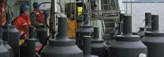
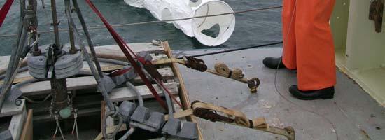
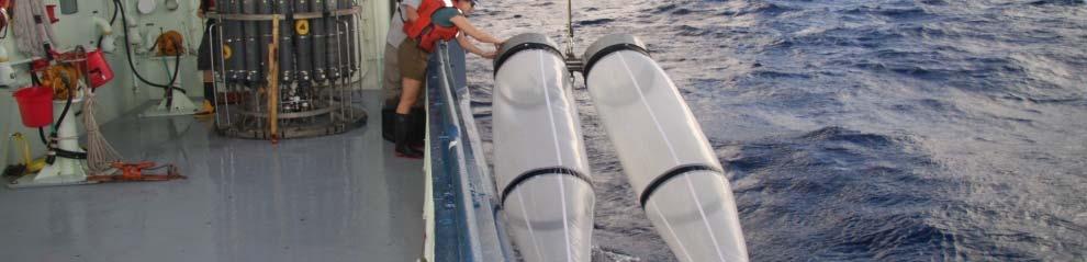
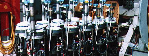
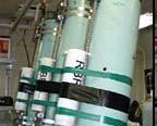
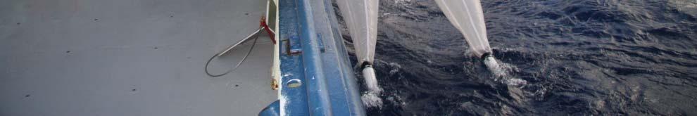
6 Data Management at BCO-DMO BCO-DMO staff work in partnership with PIs to create well-documented data sets from research programs involving a wide variety of sampling gear bco-dmo.org Biological and Chemical Oceanography Data Management Office slide 6 of 17
7 BCO-DMO Data System Data Discovery and Availability our primary task is to ensure that data from NSF OCE funded awards are freely available online the BCO-DMO data system and interfaces facilitate data discovery data access to assess fitness-for-purpose data export and download data preservation in a permanent archive (the National Oceanographic Data Center (NODC)) bco-dmo.org Biological and Chemical Oceanography Data Management Office slide 7 of 17
8 Text based browse BCO-DMO Text-based browse
9 Project: search for Atlantic
10 BCO-DMO Data System North Atlantic Bloom Experiment 2008 Principal investigators: Eric D Asaro, University of Washington, Applied Physics Laboratory Mary Jane Perry, University of Maine, Darling Marine Center Craig Lee, University of Washington, Applied Physics Laboratory Katja Fennel, Dalhousie University Data liaison: Ivona Cetinic, University of Maine Complex field sampling program four cruises, floats and glider deployments detailed supporting documentation bco-dmo.org Biological and Chemical Oceanography Data Management Office slide 10 of 17
11 Project view
12 Map-based Geospatial
13 MapServer Starting Screen BCO-DMO map-based browse bco-dmo.org Biological and Chemical Oceanography Data Management Office slide 13 of 17
14
15 Use text-based or map-based browse to access data from the BCO-DMO system
16 BCO-DMO Data System BCO-DMO Data Discovery, Access, Export data discovery using text-based or map-based browse data can be listed or graphed for quick-view assessment of fitness for purpose access and subset data sets export/download data in a variety of formats when using data in a presentation or publication, remember to properly p cite the originating g investigator bco-dmo.org Biological and Chemical Oceanography Data Management Office slide 16 of 17


17 A scholar s positive contribution is measured by the sum of the original data that he contributes. Hypotheses come and go but data remain. In: Advice to a Young Investigator (Santiago Ramón y Cajal, 1897) Thank you. Questions? bco-dmo.org Biological and Chemical Oceanography Data Management Office slide 17 of 17 photo by Chris Linder (WHOI)
GeoLink: Semantics and Linked Data for the Geosciences. The Web is the API.
 GeoLink: Semantics and Linked Data for the Geosciences The Web is the API. Goal: Bring together experts from the geo sciences, computer science, and library science; to develop Semantic Web components;
OCEANOGRAPHIC DATA MANAGEMENT
 OCEANOGRAPHIC DATA MANAGEMENT Presented to: Environmental Disaster Data Management Meeting Russ Beard Director, National Coastal Data Development Center Interim Science Coordinator, Gulf Restoration Council
Spatial Data Availability Energizes Florida s Citizens
 NASCIO 2016 Recognition Awards Nomination Spatial Data Availability Energizes Florida s Citizens State of Florida Agency for State Technology & Department of Environmental Protection Category: ICT Innovations
The Index to Marine and Lacustrine Geological Samples
 The Index to Marine and Lacustrine Geological Samples Community access to common information on sample collections Kelly J. Stroker 1, Jennifer Jencks 2 1 Cooperative Institute for Research in Environmental
Chairs: Susanne Neuer (Arizona State Univ.), Michael Lomas (Bigelow Laboratory), Angelicque White (Oregon State Univ.)
, Michael Lomas (Bigelow Laboratory), Angelicque White (Oregon State Univ.)") Plenary Session 2. Studying Spatial and Temporal Variability in the Ocean with Shipboard and Autonomous Platforms Chairs: Susanne Neuer (Arizona State Univ.), Michael Lomas (Bigelow Laboratory), Angelicque
Plenary Session 2. Studying Spatial and Temporal Variability in the Ocean with Shipboard and Autonomous Platforms Chairs: Susanne Neuer (Arizona State Univ.), Michael Lomas (Bigelow Laboratory), Angelicque
Underway Data Management via the SAMOS Initiative
 Underway Data Management via the SAMOS Initiative Shawn R. Smith 1, Jeremy Rolph 1, Kristen Briggs 1, Mark A. Bourassa 1,2, Daniel Wolfe 3, and Chris Fairall 4 1 COAPS, Florida State University, Tallahassee,
Geospatial Decision Support Tools for Planning of Marine Protected Areas in California
 Geospatial Decision Support Tools for Planning of Marine Protected Areas in California WILL MCCLINTOCK (UNIVERSITY OF CALIFORNIA SANTA BARBARA), MATT MERRIFIELD (THE NATURE CONSERVANCY), SOPHIE DE BEUKELAER
Deepwater Horizon Gulf of Mexico Oil Spill NSF Rapid Response Research
 Deepwater Horizon Gulf of Mexico Oil Spill NSF Rapid Response Research Presentation to the Ocean Leadership 2011 Public Policy Forum Consortium for Ocean Leadership Dr. David Conover National Science Foundation
A Map Through Time Virtual Historic Cities
 A Map Through Time Virtual Historic Cities NEW WAYS OF EXPLORING DIGITAL COLLECTIONS FLORIDA INTERNATIONAL UNIVERSITY JAMIE ROGERS Coral Gables Virtual Historic City & Unearthing St. Augustine s Colonial
UK Argo. AST#16, Brest, France, March Crown copyright Met Office
 UK Argo AST#16, Brest, France, March 2015 UK Argo the beginning The original commitment made by Government CSA in 1999 was that the UK would contribute to Argo to at least a GNP-level based share at full
African Coastal Atlas developments. 10 July 2008 EEA Copenhagen, Denmark
 African Coastal Atlas developments 10 July 2008 EEA Copenhagen, Denmark Africa Overview Africa has approximately 40 000 km of coast across 32 mainland countries and four island states. Africa's coastal
The Arctic Sea Ice Cover
 The Arctic Sea Ice Cover From the Living Earth Interface, Impediment, Integrator Frozen ocean 8-15 million km 2 Size of U.S. Meters thick Floating, moving ice Highly variable Large albedo Climate change!
Dynamics of Boundary Currents and Marginal Seas
 Dynamics of Boundary Currents and Marginal Seas W. E. Johns University of Miami, RSMAS/MPO 4600 Rickenbacker Causeway, Miami, Florida 33149-1098 Phone (305)361-4054; fax: (305)361-4696; email: wjohns@rsmas.miami.edu
The Canadian Ceoscience Knowledge Network. - A Collaborative Effort for Unified Access to Ceoscience Data
 The Canadian Ceoscience Knowledge Network - A Collaborative Effort for Unified Access to Ceoscience Data The Canadian Geoscience Knowledge Network A Collaborative Effort for Unified Access to Geoscience
the map Redrawing Donald Hobern takes a look at the challenges of managing biodiversity data [ Feature ]
![the map Redrawing Donald Hobern takes a look at the challenges of managing biodiversity data [ Feature ]](/thumbs/82/86628837.jpg "the map Redrawing Donald Hobern takes a look at the challenges of managing biodiversity data [ Feature ]") Redrawing the map Donald Hobern takes a look at the challenges of managing biodiversity data 46 Volume 12 > Number 9 > 2008 www.asiabiotech.com Cicadetta sp., Canberra, Australia, December 2007 Photograph
Redrawing the map Donald Hobern takes a look at the challenges of managing biodiversity data 46 Volume 12 > Number 9 > 2008 www.asiabiotech.com Cicadetta sp., Canberra, Australia, December 2007 Photograph
Northwestern Hawaiian Islands Coral Reef Research Partnership: Ocean Mapping, Ecosystem Threats, and Information Management
 Northwestern Hawaiian Islands Coral Reef Research Partnership: Ocean Mapping, Ecosystem Threats, and Information Management Malia Chow Papahanaumokuakea Marine National Monument National Oceanic and Atmospheric
Vision: The National Oceanography Centre will, by 2015, be recognised as the world-leading Centre for integrated ocean sciences and technology".
 National Oceanography Centre from coast to deep ocean Waterfront Campus, Southampton Vision: Joseph Proudman Building, Liverpool The National Oceanography Centre will, by 2015, be recognised as the world-leading
Bathymetric Attributed Grids (BAGs): Discovery of Marine Datasets and Geospatial Metadata Visualization
: Discovery of Marine Datasets and Geospatial Metadata Visualization") University of New Hampshire University of New Hampshire Scholars' Repository Center for Coastal and Ocean Mapping Center for Coastal and Ocean Mapping 2010 Bathymetric Attributed Grids (BAGs): Discovery
University of New Hampshire University of New Hampshire Scholars' Repository Center for Coastal and Ocean Mapping Center for Coastal and Ocean Mapping 2010 Bathymetric Attributed Grids (BAGs): Discovery
Appendix E: Oceanographic Databases
 Appendix E: Oceanographic Databases Many of the principal U.S. and international database depositories for worldwide ocean observations are listed below, as are a few technical reports with descriptions
2007 / 2008 GeoNOVA Secretariat Annual Report
 2007 / 2008 GeoNOVA Secretariat Annual Report Prepared for: Assistant Deputy Minister and Deputy Minister of Service Nova Scotia and Municipal Relations BACKGROUND This report reflects GeoNOVA s ongoing
Data Management for Algal Monitoring in the Gulf of Mexico
 Data Management for Algal Monitoring in the Gulf of Mexico Scott Cross NOAA National Oceanographic Data Center/ Coastal Data Development Center (NCDDC) Outline History Current & Future Directions Needs
Antarctic Marine Biodiversity Data Now Online
 Contact: Bruno Danis +32(2)6274139 bruno.danis@scarmarbin.be EMBARGOED UNTIL 9 a.m ECT, March 31 2009 Antarctic Marine Biodiversity Data Now Online An efficient network of specialists, data and tools to
GeoMAPP: Using Metadata to Help Preserve Geospatial Content
 GeoMAPP: Using Metadata to Help Preserve Geospatial Content Matt Peters, Utah s Automated Geographic Reference Center Glen McAninch, Kentucky Department for Libraries and Archives Alec Bethune, North Carolina
Enhancing Louisiana s GNIS
 Enhancing Louisiana s GNIS An Outreach Effort Between USGS and the Louisiana Geographic Information Center Louisiana Remote Sensing and GIS Workshop Lafayette, LA April 28, 2010 Louisiana Geographic Information
Proper Data Management Responsibilities to Meet the Global Ocean Observing System (GOOS) Requirements
 Requirements") Data Buoy Cooperation Panel XXVI Oban, Scotland, UK 27 September 2010 Proper Data Management Responsibilities to Meet the Global Ocean Observing System (GOOS) Requirements William Burnett Data Management
Data Buoy Cooperation Panel XXVI Oban, Scotland, UK 27 September 2010 Proper Data Management Responsibilities to Meet the Global Ocean Observing System (GOOS) Requirements William Burnett Data Management
NC Geospatial Data Archiving Project
 NC Geospatial Data Archiving Project 1. Frequency of Capture of Geospatial Data We seek your advice and experience in creating geospatial data snapshots for your archives -- versions of vector data and
An introduction to the Data Library PANGAEA. Stefanie Schumacher, Rainer Sieger & Hannes Grobe (2010)
") An introduction to the Data Library PANGAEA Stefanie Schumacher, Rainer Sieger & Hannes Grobe (2010) Data sharing and archiving Nature: Vol 461, 10 September 2009 doi:10.1038/461145a DFG Recommendations
An introduction to the Data Library PANGAEA Stefanie Schumacher, Rainer Sieger & Hannes Grobe (2010) Data sharing and archiving Nature: Vol 461, 10 September 2009 doi:10.1038/461145a DFG Recommendations
From the Venice Lagoon Atlas towards a collaborative federated system
 From the Venice Lagoon Atlas towards a collaborative federated system City of Venice Alessandro Mulazzani CORILA Consortium for Coordination of Research Activities Concerning the Venice Lagoon System ISMAR-CNR
The Global Land Cover Facility
 The Global Land Cover Facility REASoN Activities John Townshend, Principal Investigator Joseph JaJa, Co-Principal Investigator Paul Davis, Science Manager University of Maryland January 2004 The GLCF The
HAMILTON DECLARATION ON COLLABORATION FOR THE CONSERVATION OF THE SARGASSO SEA
 HAMILTON DECLARATION ON COLLABORATION FOR THE CONSERVATION OF THE SARGASSO SEA Hamilton, Bermuda 11 March, 2014 WE, THE SIGNATORIES LISTED BELOW: Recognising that the islands of Bermuda are the only land
Geofacets Seminar & Interactive Workshop
 Geofacets Seminar & Workshop University of Bergen Geofacets Seminar & Interactive Workshop UNIVERSITY OF BERGEN Sandra Merten Geofacets Product Manager University of Bergen, 22 March 2017 Geofacets Seminar
Deep-ocean observatories, biogeochemical & biophysical time-series data: NZ-Australia & international linkages
 Deep-ocean observatories, biogeochemical & biophysical time-series data: NZ-Australia & international linkages Scott Nodder (NIWA), Tom Trull (ACE-CRC, UTas, CSIRO) & Eric Schulz (BoM) IMOS NZ-Australia
Brian D. George. GIMS Specialist Ohio Coastal Atlas Project Coordinator and Cartographer. Impacts and Outcomes of Mature Coastal Web Atlases
 Ohio Coastal Atlas Project Brian D. George GIMS Specialist Ohio Coastal Atlas Project Coordinator and Cartographer Ohio Department of Natural Resources Office of Coastal Management Sandusky, OH Impacts
PROGRESS REPORT ON APPROACH PAPER THE IMPLEMENTATION OF THE GEF KNOWLEDGE MANAGEMENT. GEF/C.49/Inf.04 September 23, 2015
 49 th GEF Council Meeting October 20 22, 2015 Washington, D.C. GEF/C.49/Inf.04 September 23, 2015 PROGRESS REPORT ON THE IMPLEMENTATION OF THE GEF KNOWLEDGE MANAGEMENT APPROACH PAPER TABLE OF CONTENTS
NSF Grants Conference Denver June 23-24, 2014
 NSF Grants Conference Denver June 23-24, 2014 NSF Directorate for Geosciences Sarah Ruth, DPhil Division of Atmospheric and Geospace Sciences sruth@nsf.gov 1 Directorate for Geosciences: Our Mission Support
Modeling Low-Oxygen Regions
 Modeling Low-Oxygen Regions Andreas Schmittner College of Oceanic and Atmospheric Sciences Oregon State University 1.How well can global models simulate low- oxygen regions? 2.Long-term projections 3.Variability
OSU Ocean Observing Center
 OSU Ocean Observing Center and The Ocean Observatories Initiative OSU Retirement Association March 10,19 2016 2 Early Ocean Observations OSU Retirement Association March 10,19 2016 3 No information off
Final Report for DOEI Project: Bottom Interaction in Long Range Acoustic Propagation
 Final Report for DOEI Project: Bottom Interaction in Long Range Acoustic Propagation Ralph A. Stephen Woods Hole Oceanographic Institution 360 Woods Hole Road (MS#24) Woods Hole, MA 02543 phone: (508)
Healthy Ecosystems Grants 2 Final Report
 Healthy Ecosystems Grants 2 Final Report Project Title: The Transport of Oil to the Coast in the Top Centimeter of the Water Column Award Amount: $432,574 Awardee: Florida State University Award Start
Sistema de Informacion Geografica Peninsular de Yucatan (SIGPY): WORK PLAN for the UQROO- URI GIS Development Project
: WORK PLAN for the UQROO- URI GIS Development Project") Sistema de Informacion Geografica Peninsular de Yucatan (SIGPY): WORK PLAN for the UQROO- URI GIS Development Project Eddie Ellis, UQROO 2001 Citation: Quintana Roo, Mexico: Universidad de Quintana Roo
Sistema de Informacion Geografica Peninsular de Yucatan (SIGPY): WORK PLAN for the UQROO- URI GIS Development Project Eddie Ellis, UQROO 2001 Citation: Quintana Roo, Mexico: Universidad de Quintana Roo
Application integration: Providing coherent drug discovery solutions
 Application integration: Providing coherent drug discovery solutions Mitch Miller, Manish Sud, LION bioscience, American Chemical Society 22 August 2002 Overview 2 Introduction: exploring application integration
New EU efforts to assess the state of the marine environment: the EMODnet Chemistry pilot project
 New EU efforts to assess the state of the marine environment: the EMODnet Chemistry pilot project Matteo Vinci and Alessandra Giorgetti, OGS NODC group, OCE September 2013 - IMDIS 2013, Lucca Overview
Search for the Dubai in the remap search bar:
 This tutorial is aimed at developing maps for two time periods with in Remap (). In this tutorial we are going to develop a classification water and non-water in Dubai for the year 2000 and the year 2016.
Introduction: The Gulf of Mexico Alliance. The Gulf GAME project MERMAid and PHINS Results & Conclusions What s next? Examples
 AAG Las Vegas March 25, 2009 Introduction: Ocean governance and Ecosystem-Based Management The Gulf of Mexico Alliance Habitat Identification and Characterization The Gulf GAME project MERMAid and PHINS
The Current Status of EarthCube with an EarthScope Perspective. Tim Ahern IRIS Director of Data Services
 The Current Status of EarthCube with an EarthScope Perspective Tim Ahern IRIS Director of Data Services Key Aspects of EarthCube EarthCube Empowers cross-domain data discovery, interoperability, Current
DFO Maritimes Region Update. Gulf of Maine Council - Coastal and Marine Spatial Planning (CMSP) Committee Web-Ex May 16, 2017
 Committee Web-Ex May 16, 2017") DFO Maritimes Region Update Gulf of Maine Council - Coastal and Marine Spatial Planning (CMSP) Committee Web-Ex May 16, 2017 1 National Oceans Priorities Marine Conservation Targets Oceans Protection Plan
DFO Maritimes Region Update Gulf of Maine Council - Coastal and Marine Spatial Planning (CMSP) Committee Web-Ex May 16, 2017 1 National Oceans Priorities Marine Conservation Targets Oceans Protection Plan
Black Sea Data Access services
 Black Sea Data Access services PERSEUS Oceanographic Mediterranean and Black Sea Data Management Cast Data Base with vertical profiles of physical, chemical and biological data acquired with Bottle casts
Designing Networks of Marine Protected Areas in DFO s Three Atlantic Bioregions
 Designing Networks of Marine Protected Areas in DFO s Three Atlantic Bioregions Presentation for Indigenous Protected Areas Workshop Max Westhead, DFO and Adrian Gerhartz-Abraham, Dalhousie March 29, 2017
Seismic Oceanography and the R/V Langseth
 Seismic Oceanography and the R/V Langseth W. Steven Holbrook University of Wyoming cknowledgments: Ray Schmitt, WHOI Ilker Fer, Bjerknes Center, Bergen Pedro Páramo Papia Nandi Joel Seymour Andrew Bullock
FireFamilyPlus Version 5.0
 FireFamilyPlus Version 5.0 Working with the new 2016 NFDRS model Objectives During this presentation, we will discuss Changes to FireFamilyPlus Data requirements for NFDRS2016 Quality control for data
Kentucky Collaborates in GeoMAPP Project: The Advantages and Challenges of Archiving in a State with a Centralized GIS
 Kentucky Collaborates in GeoMAPP Project: The Advantages and Challenges of Archiving in a State with a Centralized GIS Geospatial Multistate Archive and Preservation Partnership By Glen McAninch Best Practices
Ontology Summit Framing the Conversation: Ontologies within Semantic Interoperability Ecosystems
 Ontology Summit 2016 Framing the Conversation: Ontologies within Semantic Interoperability Ecosystems GeoSciences Track: Semantic Interoperability in the GeoSciences Gary Berg-Cross and Ken Baclawski Co-Champions
The PREVIEW Global Risk Data Platform: a geoportal to serve and share global data on risk to natural hazards
 The PREVIEW Global Risk Data Platform: a geoportal to serve and share global data on risk to natural hazards Gregory Giuliani (UNEP/GRID-Geneva & University of Geneva/enviroSPACE ) http://www.grid.unep.ch
Ministry of Health and Long-Term Care Geographic Information System (GIS) Strategy An Overview of the Strategy Implementation Plan November 2009
 Strategy An Overview of the Strategy Implementation Plan November 2009") Ministry of Health and Long-Term Care Geographic Information System (GIS) Strategy An Overview of the Strategy Implementation Plan November 2009 John Hill, Health Analytics Branch Health System Information
Ministry of Health and Long-Term Care Geographic Information System (GIS) Strategy An Overview of the Strategy Implementation Plan November 2009 John Hill, Health Analytics Branch Health System Information
Archiving of OCS Invertebrate Specimens and Genomic Tissue Samples. NMNH, Department of Invertebrate Zoology April 2018 SAML Annual Meeting
 Archiving of OCS Invertebrate Specimens and Genomic Tissue Samples NMNH, Department of Invertebrate Zoology April 2018 SAML Annual Meeting Department of Invertebrate Zoology invertebrates.si.edu Dr. Ellen
The Physical Context for Thin Layers in the Coastal Ocean
 The Physical Context for Thin Layers in the Coastal Ocean David M. Fratantoni Physical Oceanography Department Woods Hole Oceanographic Institution Woods Hole, MA 02543 phone: (508) 289-2908 fax: (508)
NOAA s Big Data Project: Vision and Approach
 NOAA s Big Data Project: Vision and Approach Andy Bailey, BDP Technical Lead NOAA Office of the Chief Information Officer What is NOAA? United States Government Agency NOAA ~ National Oceanic and Atmospheric
About peer review missions related to data management
 PEER REVIEW WORKSHOP ABOUT DATA MANAGEMENT Introduction Paul HAENER International Office for Water FRANCE p.haener@oieau.fr October 2016 About peer review missions related to data management 2 1 Data management
Developing a Guide for Non-experts to Determine the Most Appropriate Use of Solar Energy Resource Information
 Developing a Guide for Non-experts to Determine the Most Appropriate Use of Solar Energy Resource Information Carsten Hoyer-Klick 1*, Jennifer McIntosh 2, Magda Moner-Girona 3, David Renné 4, Richard Perez
PROCESSING RECORD SCRIPPS INSTITUTION OF OCEANOGRAPHY ARCHIVES
 Accession No.:- PROCESSING RECORD SCRIPPS INSTITUTION OF OCEANOGRAPHY ARCHIVES Winant, Clinton D. - Clinton D. Winant Papers, - Physical Description: mss, ½ mss Arrangement of Collection: Arranged in four
Data Aggregation with InfraWorks and ArcGIS for Visualization, Analysis, and Planning
 Data Aggregation with InfraWorks and ArcGIS for Visualization, Analysis, and Planning Stephen Brockwell President, Brockwell IT Consulting, Inc. Join the conversation #AU2017 KEYWORD Class Summary Silos
Search for the Dubai in the remap search bar:
 This tutorial is aimed at developing maps for two time periods with in Remap (). In this tutorial we are going to develop a classification water and non-water in Dubai for the year 2000 and the year 2016.
ADVANCES OF INTERDISCIPLINARY CARTOGRAPHY IN THE HIMALAYAN MOUNTAINS
 Geographia Technica, Special Issue, 2010, pp. 120 to 125 ADVANCES OF INTERDISCIPLINARY CARTOGRAPHY IN THE HIMALAYAN MOUNTAINS David SCHOBESBERGER 1, Karel KRIZ 1 ABSTRACT: This paper follows up on the
Spatial Data Infrastructure Concepts and Components. Douglas Nebert U.S. Federal Geographic Data Committee Secretariat
 Spatial Data Infrastructure Concepts and Components Douglas Nebert U.S. Federal Geographic Data Committee Secretariat August 2009 What is a Spatial Data Infrastructure (SDI)? The SDI provides a basis for
Ke Chen. Department of Physical Oceanography
 Ke Chen Postdoctoral Investigator kchen@whoi.edu Department of Physical Oceanography +1 508.289.2308 Woods Hole Oceanographic Institution www.whoi.edu/people/kchen/ EDUCATION: 2011 Ph.D., Physical Oceanography,
Metadata Catalogue of Diatom Names
 Metadata Catalogue of Diatom Names Exported from the Freshwater Biodiversity Data Portal, http://data.freshwaterbiodiversity.eu Visit the Freshwater Metadatabase, http://data.freshwaterbiodiversity.eu/metadb/about_metadata
WDCS IN OBNINSK, RUSSIA: ON A WAY TO WDS RESOURCE INTEGRATION
 WDCS IN OBNINSK, RUSSIA: ON A WAY TO WDS RESOURCE INTEGRATION VALERIY KOSYKH, EVGENII VIAZILOV, ALEXANDER STERIN, OLGA BULYGINA RIHMI-WDC, OBNINSK RUSSIA ABOUT WDCS OBNINSK: SOME HISTORY IGY 1957: HISTORICALLY,
Office of Technology Partnerships GIS Collaboration
 Office of Technology Partnerships GIS Collaboration State GIS Update April 21, 2017 Mark Holmes, GISP Outline MGF Upgrade Project Census Programs Imagery Update LiDAR Update Open Discussion 2 MGF Background
an accessible interface to marine environmental data Russell Moffitt
 an accessible interface to marine environmental data Russell Moffitt The Atlas Project GOAL: To provide a single point of access to oceanographic and environmental data for use by marine resource researchers,
BOEM Marine Minerals Program
 BOEM Marine Minerals Program Restoring and Protecting Our Nation s Coasts through Stewardship of OCS Sand Resources SECOORA 2018 Annual Meeting May 22-24 Doug Piatkowski Douglas.piatkowski@boem.gov 703-787-1833
Argo data management November 2nd, 2005 Ref : cordo/dti-rap/ Version 1.1 ARGO DATA MANAGEMENT REPORT FRENCH DAC
 Argo data management November 2nd, 2005 Ref : cordo/dti-rap/05-145 Version 1.1 ARGO DATA MANAGEMENT REPORT FRENCH DAC 2 Argo National Data Management Report of France November 2005 Introduction This document
The purpose of this report is to recommend a Geographic Information System (GIS) Strategy for the Town of Richmond Hill.
 Strategy for the Town of Richmond Hill.") Staff Report for Committee of the Whole Meeting Department: Division: Subject: Office of the Chief Administrative Officer Strategic Initiatives SRCAO.18.12 GIS Strategy Purpose: The purpose of this report
Staff Report for Committee of the Whole Meeting Department: Division: Subject: Office of the Chief Administrative Officer Strategic Initiatives SRCAO.18.12 GIS Strategy Purpose: The purpose of this report
Computational Biology, University of Maryland, College Park, MD, USA
 1 Data Sharing in Ecology and Evolution: Why Not? Cynthia S. Parr 1 and Michael P. Cummings 2 1 Institute for Advanced Computer Studies, 2 Center for Bioinformatics and Computational Biology, University
SCAR AAA and its objectives
 SCAR AAA and its objectives John Storey, Chief Officer, AAA Image: Craig Kulesa Work program Our two tasks for this weekend: Write the astronomy & astrophysics submission to the Practical Guide to Enabling
USGS National Geospatial Program Understanding User Needs. Dick Vraga National Map Liaison for Federal Agencies July 2015
 + USGS National Geospatial Program Understanding User Needs Dick Vraga National Map Liaison for Federal Agencies July 2015 + Topics 2 Background Communities of Use User Surveys National Map Liaisons Partnerships
Predicting Marine Physical-Biogeochemical Variability in the Gulf of Mexico and Southeastern U.S. Shelf Seas
 Predicting Marine Physical-Biogeochemical Variability in the Gulf of Mexico and Southeastern U.S. Shelf Seas Ruoying He Joe Zambon, Xiangming Zeng, Haibo Zong, Nabi Allahdadi, Shun Mao Ocean Observing
Search for the Gulf of Carpentaria in the remap search bar:
 This tutorial is aimed at getting you started with making maps in Remap (). In this tutorial we are going to develop a simple classification of mangroves in northern Australia. Before getting started with
On-line demonstrator experiment implemented CODE: DEL-040 VERSION: 01
 GLORIA is funded by the European Union 7th Framework Programme (FP7/2007-2013) under grant agreement n 283783 CODE: DEL-040 VERSION: 01 DATE: October 22nd, 2012 Authors: Chris LINTOTT (UOXF) Robert SIMPSON
The Arctic Landscape Conservation Cooperative Conservation Goals
 The Arctic Landscape Conservation Cooperative Conservation Goals Adopted by the Arctic LCC Steering Committee, 24 August 2010 Background : Landscape Conservation Cooperatives and Climate Science Centers
Telepresence In The Ocean
 The Ocean Observatories Initiative: Establishing A Sustained And Adaptive Telepresence In The Ocean Shelby Walker (1) (1) National Oceanic and Atmospheric Administration, Office of Oceanic and Atmospheric
THE ARABIAN SEA: A NATURAL EXPERIMENT IN PHYTOPLANKTON BIOGEOGRAPHY
 THE ARABIAN SEA: A NATURAL EXPERIMENT IN PHYTOPLANKTON BIOGEOGRAPHY LONG TERM GOALS A. Michelle Wood Department of Biology University of Oregon Eugene, Oregon 97403 541-346-0454 email:miche@darkwing.,uoregon.edu
Geoscience Information Network (US GIN)
") Geoscience Information Network (US GIN) 1,000 s of databases 1,000 s of collections 80,000+ geologic maps Distributed Web-based Interoperable Open source A different business model Traditional Lobby Congress
Geoscience Information Network (US GIN) 1,000 s of databases 1,000 s of collections 80,000+ geologic maps Distributed Web-based Interoperable Open source A different business model Traditional Lobby Congress
OPEN ACCESS GEOLOGY: USING THE INSTITUTIONAL REPOSITORY TO HOST STATE GEOLOGICAL SURVEY PUBLICATIONS
 OPEN ACCESS GEOLOGY: USING THE INSTITUTIONAL REPOSITORY TO HOST STATE GEOLOGICAL SURVEY PUBLICATIONS Lisa Johnston and Harvey Thorleifson Science and Engineering Library, University of Minnesota, 108 Walter
Conference panel Session 98, Defining Data Professionals A Geospatial Industry Perspective on Becoming a Data Professional
 Conference panel Session 98, Defining Data Professionals A Geospatial Industry Perspective on Becoming a Data Professional Dawn J. Wright, Environmental Systems Research Institute (aka Esri), Redlands,
Lateral Mixing Progress Report November 8, 2012
 DISTRIBUTION STATEMENT A. Approved for public release; distribution is unlimited. Lateral Mixing Progress Report November 8, 2012 Jody Klymak School of Earth and Ocean Sciences University of Victoria P.O.
Introduction To Marine Biology Bio 228
 We have made it easy for you to find a PDF Ebooks without any digging. And by having access to our ebooks online or by storing it on your computer, you have convenient answers with introduction to marine
Proposal to establish a SCOR Working Group to plan and implement GEOTRACES
 Note from Ed Urban: Organizers of GEOTRACES are involved with the SCOR/IGBP Ocean Biogeochemistry and Ecosystems Analysis project in discussions about the role of portions of GEOTRACES as components of
Some of the underlying goals of the GIS Library are to:
 1 2001 It was born out of the recognition that several of the regions prominent resource management agencies have similar, if not shared, requirements for GIS data. Some of the underlying goals of the
Giant Pandas: Biology And Conservation READ ONLINE
 Giant Pandas: Biology And Conservation READ ONLINE If you are searching for a ebook Giant Pandas: Biology and Conservation in pdf format, then you've come to the correct site. We present complete variant
A National Outer Continental Shelf Sand / Sediment Inventory
 A National Outer Continental Shelf Sand / Sediment Inventory Sand Resource Areas Lease Areas Lora Turner December 15, 2016 Restoring and Protecting Our Nation s Coasts through Stewardship of OCS Resources
PRIORITY TWO-YEAR ACTIVITIES ( ) PRIORITY ONE: INTERNATIONAL RECOGNITION OF ECOLOGICAL IMPORTANCE
 PRIORITY ONE: INTERNATIONAL RECOGNITION OF ECOLOGICAL IMPORTANCE") PREFACE: The Work Programme goals and priority activities were developed at the Second Joint Meeting of the Signatories to the Hamilton Declaration and the Sargasso Sea Commission, held in Key West Florida,
PREFACE: The Work Programme goals and priority activities were developed at the Second Joint Meeting of the Signatories to the Hamilton Declaration and the Sargasso Sea Commission, held in Key West Florida,
Mapping on the Edge: shoreline mapping for regulation and voluntary stewardship
 Western Washington University Western CEDAR Salish Sea Ecosystem Conference 2016 Salish Sea Ecosystem Conference (Vancouver, BC) Mapping on the Edge: shoreline mapping for regulation and voluntary stewardship
OUR COASTAL FUTURES. A Strategy for the Sustainable Development of the World s Coasts.
 OUR COASTAL FUTURES A Strategy for the Sustainable Development of the World s Coasts www.futureearthcoasts.org Iqaluit, Nunavut, Canada. Photo by Don Forbes Coastal zones are the frontline in our global
Substantial energy input to the mesopelagic ecosystem from the seasonal mixed-layer pump
 SUPPLEMENTARY INFORMATION DOI: 10.1038/NGEO2818 Substantial energy input to the mesopelagic ecosystem from the seasonal mixed-layer pump Giorgio Dall Olmo, James Dingle, Luca Polimene, Robert J. W. Brewin
Collaborative Geotechnical BIM technologies. Carl Grice Software Development Director (Keynetix) Holger Kessler - Team Leader Modelling Systems (BGS)
 Holger Kessler - Team Leader Modelling Systems (BGS)") Collaborative Geotechnical BIM technologies Carl Grice Software Development Director (Keynetix) Holger Kessler - Team Leader Modelling Systems (BGS) 1 2 3 Current Challenges R&D Project Proposed Solution
Collaborative Geotechnical BIM technologies Carl Grice Software Development Director (Keynetix) Holger Kessler - Team Leader Modelling Systems (BGS) 1 2 3 Current Challenges R&D Project Proposed Solution
Introduction. Elevation Data Strategy. Status and Next Steps
 1 2 Introduction Elevation Data Strategy Status and Next Steps 3 Canada is the 2nd largest country in the world - 9.9 million sq km Surrounded by 3 oceans with 202 000 km of coastline Population over 35
J8.7 SHIPBOARD AUTOMATED METEOROLOGICAL AND OCEANOGRAPHIC SYSTEMS: A KEY COMPONENT OF AN OCEAN OBSERVING SYSTEM. Shawn R. Smith*
 J8.7 SHIPBOARD AUTOMATED METEOROLOGICAL AND OCEANOGRAPHIC SYSTEMS: A KEY COMPONENT OF AN OCEAN OBSERVING SYSTEM Shawn R. Smith* Center for Ocean-Atmospheric Prediction Studies, The Florida State University,
Data & Information Management in IIOE-2 IndOOS and sources of IO data
 Data & Information Management in IIOE-2 IndOOS and sources of IO data Louise Wicks IOC Perth Programme Office IOC/IIOE2-OTGA and IORA Joint Training Course: Research Data Management 22-26 May 2016: Kuala
Handling Human Interpreted Analytical Data. Workflows for Pharmaceutical R&D. Presented by Peter Russell
 Handling Human Interpreted Analytical Data Workflows for Pharmaceutical R&D Presented by Peter Russell 2011 Survey 88% of R&D organizations lack adequate systems to automatically collect data for reporting,
SciFinder Scholar Guide to Getting Started
 SciFinder Scholar Guide to Getting Started What is SciFinder Scholar? SciFinder Scholar is the online version of Chemical Abstracts, covering chemistry publications worldwide from 1907 to the present.