Big Data and Geospatial Cyberinfrastructure for Advancing Applications
|
|
|
- Janis Berry
- 6 years ago
- Views:
Transcription


1 Big Data and Geospatial Cyberinfrastructure for Advancing Applications Presented at GIScience 2012 Big Data and CyberGIS Panel Budhendra Bhaduri September 20, 2012 Columbus, OH


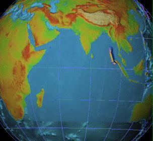
2 Geospatial Cyberinfrastructure Provides access to best in class, geographically distributed resources Data Scalable computation Visualization Platform for data integration and knowledge dissemination Enables on time and on demand information and knowledge delivery, particularly for time critical mission support
 trying to understand her You feel she s influencing your life Sometimes a challenge, but sometimes a")

3 In the Garden of Big and Evil Big Data is your mother in law! You know she exists You are (still) trying to understand her You feel she s influencing your life Sometimes a challenge, but sometimes a solution Not sure when to deal with and when to ignore But your wife knows you lover her (and she s right)! How BIG is big? What we can t handle today Its not about the needle, but about defining the haystack! A CyberGIS enabled GIScience community could Define the needle (new challenges) Do better in finding the needle (novel analytics) Make a bigger haystack (keep adding data)


 Climate data analytics and visualization")
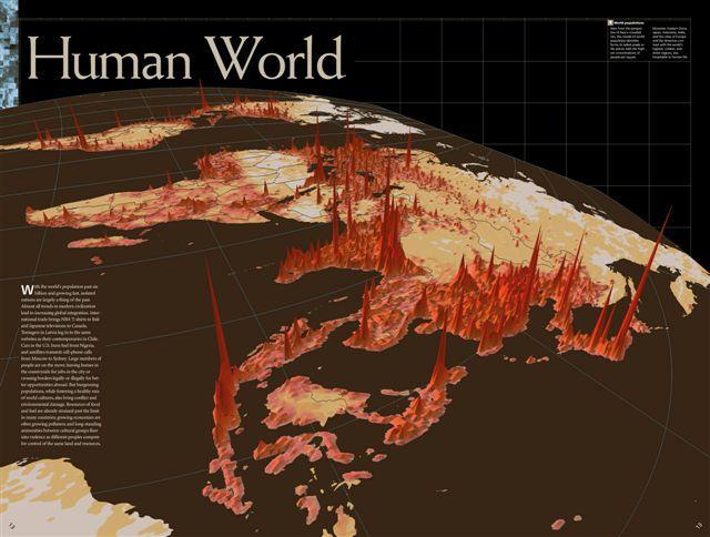
4 ORNL activities Population Assessment Web service for LandScan population data Population Density Tables portal Settlement and Damage Assessment Dynamic computation for settlement mapping and damage assessment Collaborative Knowledge Discovery Transportation Analysis Bioenergy KDF: Cyber platform for sharing data and resources Sensorpedia: Wikipedia for sensors Routing and contingency analysis Evacuation modeling Energy Security EARSS: Real time monitoring for the electric grid Large scale biomass monitoring Visualization (iglobe) Climate data analytics and visualization Spatio-temporal data mining as a service


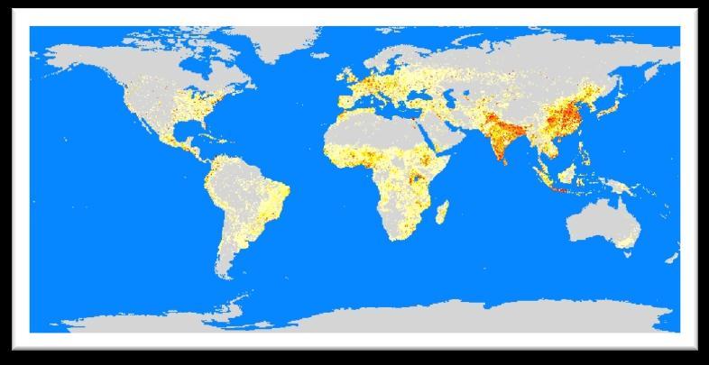


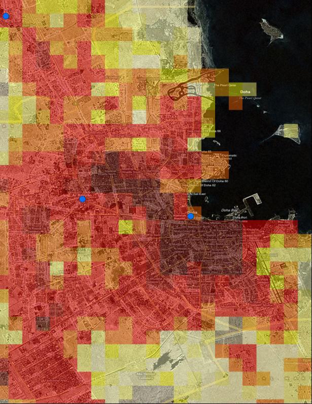

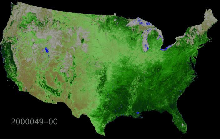
5 LandScan Population Distribution and Dynamics Model and Database Census LandScan Global Gridded Night Day LandScan USA As the finest population distribution data ever produced for the world and the US, LandScan Global and LandScan USA are the community standard for estimating population at risk


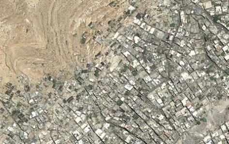
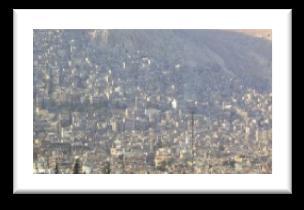
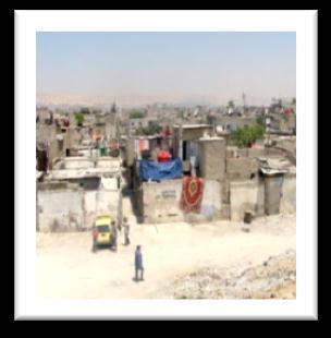
6 Neighborhood mapping: From local interactions to global realizations Unstructured Settlements Lowest to lower middle income Rural migrants Damascus, Syria Very loosely structured Historical ethnic quarters/neighborhoods Poor residents currently being displaced in some areas with urban development/tourism Formal Urban Planning Typical Urban Services Middle to Upper Income


 RGB")


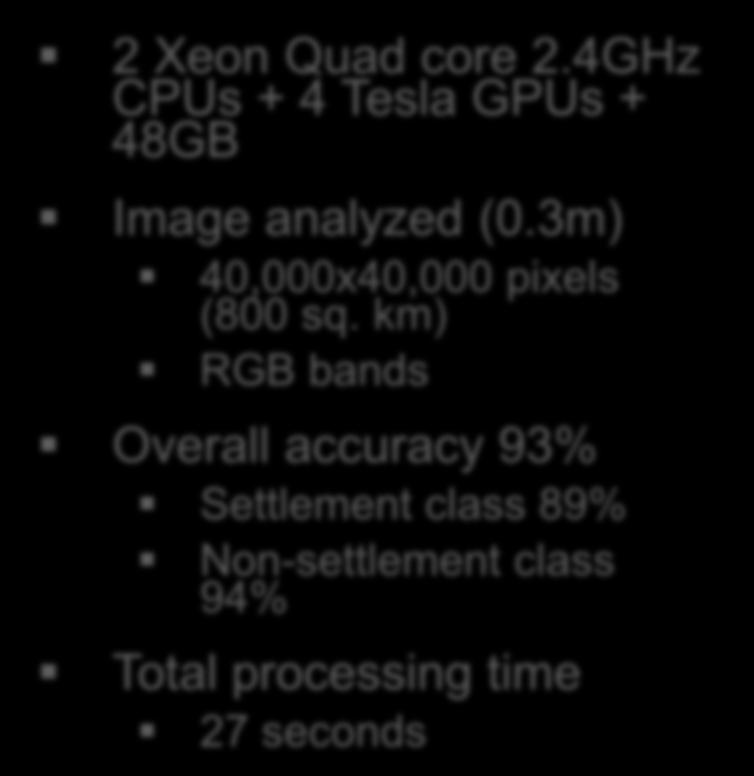
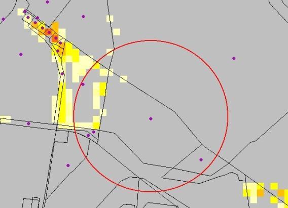
7 Addis Ababa, Ethiopia 2 Xeon Quad core 2.4GHz CPUs + 4 Tesla GPUs + 48GB Image analyzed (0.3m) 40,000x40,000 pixels (800 sq. km) RGB bands Overall accuracy 93% Settlement class 89% Non-settlement class 94% Total processing time 27 seconds

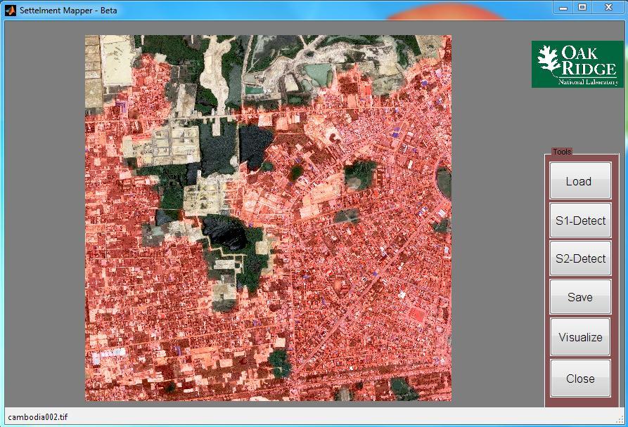
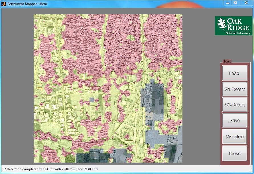
8 Settlement characterization tool
9

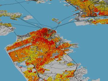
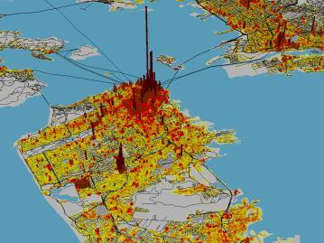
10 LandScan Data Accessed Through Google Earth Interface
11


12 June 20,2007 July 19,2007 Fargo,ND Fargo,ND Sunflower Sunflower Corn Corn Soybeans Soybeans
13
14 Successful change prediction with Gaussian Process Model MODIS NDVI Time Series from Iowa 6 years ( ) 23 observations per year Trained for first 5 years and monitored last year Accuracy was 88% on a validation set consisting of 97 labeled time series with 13 true changes No Change Variance Predicted Observed Varun Chandola, Ranga Raju Vatsavai: Scalable Time Series Change Detection for Biomass Monitoring Using Gaussian Process. NASA CIDU 2010: (One of the best papers, invited to SADM Journal). Change
 41,105 seconds (11.4 hours) 5,872 seconds (1.")
15 Wide area biomass monitoring in near real time is becoming a reality MODIS Tile (4800x4800 pixels) 42,76,383 time series FROST: An SGI Altrix ICE 8200 Cluster at ORNL 128 compute nodes each with 16 virtual cores and 24 GB of RAM Serial Threads (16) 41,105 seconds (11.4 hours) 5,872 seconds (1.6 hours) Multicore (multithreaded) and Distributed (message passing) computing strategy MPI (96 nodes) MPI + Threads (1536 cores) 604 seconds (10 minutes) 34 seconds

16 Scalable analytics and visualization iglobe: an integrated visualization and analysis environment Built using Open Source NASA World Wind Java SDK library Collaboration amongst ORNL, NASA Ames, CSIRO, NCAR, NOAA, and University of Kansas Support for different data access mechanisms via OGC compliant web services Allows interactive visualization and analysis of time series data Support for server side and client side data analysis algorithms for identifying patterns in spatiotemporal data Support for advanced time series and spatial analysis Support for advanced visualization capabilities (vector fields, animations)


17 Population Density Tables (PDT) Population/1000 ft 2 42 structural facility categories in 8 land use classes Documented data sources and methodology with traceable provenance Open source collection from reputed sources Published sources include academic journals, official government statistics, corporate and university webpages, tourism brochures. Utilizing other sources such as GeoCommunity, Wikipedia, Panoramia, and Wikimapia. Spatial Resolution/extent Region, Nation,, City, Neighborhood Temporal resolution Diurnal Workweek/weekend Episodic/holidays/special event Seasonal Political and socio-economic characteristics will be included in the future Ethnic Religious Racial Political affinity Economic strength Available as a web service on SIPR:


18 Making Big Data Bigger and Better CyberGIS can create a community platform for data What if we could assemble all the LULC data and maps produced by graduate student thesis research? Collective contributions from scientific communities Similar to Internet interest groups and social networks (Facebook, Twitter) Individual contributions through VGI and crowd sourcing May become part of our open data economy Seems like we want more not exactly knowing how much more we really need to solve specific problems Its probably all about organizing the haystack(s) and CyberGIS can help Managed by UT-Battelle
Oak Ridge Urban Dynamics Institute
 Oak Ridge Urban Dynamics Institute Presented to ORNL NEED Workshop Budhendra Bhaduri, Director Corporate Research Fellow July 30, 2014 Oak Ridge, TN Our societal challenges and solutions are often local
Space-adjusting Technologies and the Social Ecologies of Place
 Space-adjusting Technologies and the Social Ecologies of Place Donald G. Janelle University of California, Santa Barbara Reflections on Geographic Information Science Session in Honor of Michael Goodchild
Cyberinfrastructure and CyberGIS: Recent Advances and Key Themes
 Cyberinfrastructure and CyberGIS: Recent Advances and Key Themes Shaowen Wang CyberInfrastructure and Geospatial Information Laboratory (CIGI) Department of Geography Department of Computer Science National
Spatial Analysis in CyberGIS
 Spatial Analysis in CyberGIS towards a spatial econometrics workbench Luc Anselin, Sergio Rey and Myunghwa Hwang GeoDa Center School of Geographical Sciences and Urban Planning Arizona State University
Spatial Data Science. Soumya K Ghosh
 Workshop on Data Science and Machine Learning (DSML 17) ISI Kolkata, March 28-31, 2017 Spatial Data Science Soumya K Ghosh Professor Department of Computer Science and Engineering Indian Institute of Technology,
Multi agent Evacuation Simulation Data Model for Disaster Management Context
 Multi agent Evacuation Simulation Data Model for Disaster Management Context Mohamed Bakillah, Alexander Zipf, J. Andrés Domínguez, Steve H. L. Liang GI4DM 2012 1 Content Context Requirements for Enhanced
CARTOGRAPHY in a Web World
 CARTOGRAPHY in a Web World Nationale GI Minor BAREND KÖBBEN b.j.kobben@utwente.nl Agenda Short introduction to ITC and me Cartography: communicating spatial data Changing GIS & Cartography technology:
G. I. Science Education: A Computing Perspective
 A Position Statement on G. I. Science Education: A Computing Perspective (A Panel Discussion in UCGIS Summer Assembly 2008) By Shashi Shekhar McKnight Distinguished University Professor Faculty of Computer
KUNMING FORUM ON UNITED NATIONS GLOBAL GEOSPATIAL INFORMATION MANAGEMENT CITIES OF THE FUTURE: SMART, RESILIENT
 KUNMING FORUM ON UNITED NATIONS GLOBAL GEOSPATIAL INFORMATION MANAGEMENT CITIES OF THE FUTURE: SMART, RESILIENT and SUSTAINABLE Yunnan Zhenzhuang Guest House, Kunming, China 10 12 May 2017 BACKGROUND CONCEPT
Techniques for Science Teachers: Using GIS in Science Classrooms.
 Techniques for Science Teachers: Using GIS in Science Classrooms. After ESRI, 2008 GIS A Geographic Information System A collection of computer hardware, software, and geographic data used together for
An Alternate Career Choice for the Geography Major: Map, GIS, or Geographic Information Librarianship
 An Alternate Career Choice for the Geography Major: Map, GIS, or Geographic Information Librarianship Katherine H. Weimer Texas A&M University Libraries SWAAG 2007 - Bryan, Texas Overview of today s talk
SA Geospatial Analysis Platform (GAP) Methodology*, collaborators & data sources
 Methodology*, collaborators & data sources") SA Geospatial Analysis Platform (GAP) Methodology*, collaborators & data sources Mesoframe CSIR, dti, the Presidency & GTZ Demarcation of South Africa into a grid of 50 Km 2 mesozones, nested within important
SA Geospatial Analysis Platform (GAP) Methodology*, collaborators & data sources Mesoframe CSIR, dti, the Presidency & GTZ Demarcation of South Africa into a grid of 50 Km 2 mesozones, nested within important
TRAITS to put you on the map
 TRAITS to put you on the map Know what s where See the big picture Connect the dots Get it right Use where to say WOW Look around Spread the word Make it yours Finding your way Location is associated with
Smart Citizens. Maria Antonia Brovelli Politecnico di Milano, Italy
 Smart Citizens Maria Antonia Brovelli Politecnico di Milano, Italy UN-GGIM Academic Network Forum Secure Land Rights and Smart Cities: Making It Work for Sustainable Development New York, 31 July 2017
Geospatial Information and Services for Disasters (GIS4D)
") Geospatial Information and Services for Disasters (GIS4D) 31 July 2017 Tae Hyung KIM ICT and Disaster Risk Reduction Division (IDD) UNESCAP 1 About ESCAP Who is ESCAP? United Nations Economic and Social
Geospatial Information and Services for Disasters (GIS4D) 31 July 2017 Tae Hyung KIM ICT and Disaster Risk Reduction Division (IDD) UNESCAP 1 About ESCAP Who is ESCAP? United Nations Economic and Social
Instituto de Pesquisas Meteorológicas - IPMet Universidade Estadual Paulista - Unesp
 IPMET WEB GIS APPLICATION FOR SEVERE WEATHER ALERT AND DECISION SUPPORT Jaqueline Murakami Kokitsu Instituto de Pesquisas Meteorológicas - IPMet Universidade Estadual Paulista - Unesp IPMet/Unesp Meteorological
Climate Risk Visualization for Adaptation Planning and Emergency Response
 Climate Risk Visualization for Adaptation Planning and Emergency Response NCR Flood Fact Finding Workshop Ricardo Saavedra ricardo@vizonomy.com Social Media, Mobile, and Big Data St. Peter s Basilica,
ASSESSING THE ARTS COMMUNITY: Mapping with GIS and Social Media Tools
 ASSESSING THE ARTS COMMUNITY: Mapping with GIS and Social Media Tools Gary Coutu Associate Professor Department of Geography and Planning West Chester University July 15, 2014 Mapping with GIS and Social
ELF products in the ArcGIS platform
 ELF products in the ArcGIS platform Presentation to: Author: Date: NMO Summit 2016, Dublin, Ireland Clemens Portele 18 May 2016 The Building Blocks 18 May, 2016 More ELF users through affiliated platforms
UTAH S STATEWIDE GEOGRAPHIC INFORMATION DATABASE
 UTAH S STATEWIDE GEOGRAPHIC INFORMATION DATABASE Data Information and Knowledge Management NASCIO Awards 2009 STATE GEOGRAPHIC INFORMATION DATABASE B. EXECUTIVE SUMMARY Utah has developed one of the most
Key Points Sharing fosters participation and collaboration Metadata has a big role in sharing Sharing is not always easy
 Sharing Resources Geoff Mortson esri, Inc. SDI Solutions Team Key Points Sharing fosters participation and collaboration Metadata has a big role in sharing Sharing is not always easy Data Sharing is Good
ArcGIS is Advancing. Both Contributing and Integrating many new Innovations. IoT. Smart Mapping. Smart Devices Advanced Analytics
 ArcGIS is Advancing IoT Smart Devices Advanced Analytics Smart Mapping Real-Time Faster Computing Web Services Crowdsourcing Sensor Networks Both Contributing and Integrating many new Innovations ArcGIS
Looking at Communities: Comparing Urban and Rural Neighborhoods
 Looking at Communities: Comparing Urban and Rural Neighborhoods OVERVIEW & OBJECTIVES Our urban areas have become so dominant that frequently the children we teach have no connection with and very few
Exploring Digital Welfare data using GeoTools and Grids
 Exploring Digital Welfare data using GeoTools and Grids Hodkinson, S.N., Turner, A.G.D. School of Geography, University of Leeds June 20, 2014 Summary As part of the Digital Welfare project [1] a Java
Geospatial SDI Portal for effective Governance of Pune METROPOLIS region
 Geospatial SDI Portal for effective Governance of Pune METROPOLIS region Mr. Praveen Gautam Senior Manager 19 th January 2018 PMRDA Overview Provide a Spatial Framework for the entire region with various
Institute of Statistical and Geographical Information of Jalisco State Geospatial Technologies, platforms and services at a subnational level
 Institute of Statistical and Geographical Information of Jalisco State Geospatial Technologies, platforms and services at a subnational level México, November 2017 Unique organization in its type SDG 17.18:
Scalable and Power-Efficient Data Mining Kernels
 Scalable and Power-Efficient Data Mining Kernels Alok Choudhary, John G. Searle Professor Dept. of Electrical Engineering and Computer Science and Professor, Kellogg School of Management Director of the
Oman NSDI Supporting Economic Development. Saud Al-Nofli Director of Spatial Data Directorate General of NSDI, NCSI
 Oman NSDI Supporting Economic Development 2017 Saud Al-Nofli Director of Spatial Data Directorate General of NSDI, NCSI "It s critical to make correct decisions the first time to optimize the Investments
a national geological survey perspective François ROBIDA BRGM (French Geological Survey)
") a national geological survey perspective François ROBIDA BRGM (French Geological Survey) Pre-Conference Seminar on Socio-Economic Value of Geospatial for National and Regional Development 21 August 2017,
a national geological survey perspective François ROBIDA BRGM (French Geological Survey) Pre-Conference Seminar on Socio-Economic Value of Geospatial for National and Regional Development 21 August 2017,
ASIA GEOSPATIAL FORUM 2011 Eco-Friendly Walk Score Calculator Choosing a Place to Live with GIS
 ASIA GEOSPATIAL FORUM 2011 Eco-Friendly Walk Score Calculator Choosing a Place to Live with GIS Ko Ko Lwin and Yuji Murayama Division of Spatial Information Science Graduate School of Life and Environmental
Analyzing Multidimensional Scientific Data in ArcGIS. Nawajish Noman Deng Ding
 Analyzing Multidimensional Scientific Data in ArcGIS Nawajish Noman Deng Ding Outline Part I - ArcGIS Platform - Scientific Multidimensional Data - Ingest and Data Management Part II - Data Exploration
Discovery and Access of Geospatial Resources using the Geoportal Extension. Marten Hogeweg Geoportal Extension Product Manager
 Discovery and Access of Geospatial Resources using the Geoportal Extension Marten Hogeweg Geoportal Extension Product Manager DISCOVERY AND ACCESS USING THE GEOPORTAL EXTENSION Geospatial Data Is Very
Foundations of Urbanization Science: Mapping and Measuring Global Urban Metabolism
 Foundations of Urbanization Science: Mapping and Measuring Global Urban Metabolism Professor Paul C. Sutton Department of Geography & the Environment University of Denver Denver, CO 80208 Human Planet
Mapping for a Changing California
 Mapping for a Changing California Spatial Data Science: - the 21 st century mapping toolkit - case studies in remote sensing and participatory informatics -where to get more information Maggi Kelly, University
High resolution population grid for the entire United States
 High resolution population grid for the entire United States A. Dmowska, T. F. Stepinski Space Informatics Lab, Department of Geography, University of Cincinnati, Cincinnati, OH 45221-0131, USA Telephone:
Application of WebGIS and VGI for Community Based Resources Inventory. Jihn-Fa Jan Department of Land Economics National Chengchi University
 Application of WebGIS and VGI for Community Based Resources Inventory Jihn-Fa Jan Department of Land Economics National Chengchi University OUTLINE Introduction Methodology Results Conclusions 2 MOTIVATION
Combination of high resolution satellite images population census statistics to estimating population exposed to risks of disaster
 Combination of high resolution satellite images population census statistics to estimating population exposed to risks of disaster Daniel Clarke (UNESCAP) Jean-Louis Weber (Consultant-UNESCAP) Disaster
The Challenge of Geospatial Big Data Analysis
 288 POSTERS The Challenge of Geospatial Big Data Analysis Authors - Teerayut Horanont, University of Tokyo, Japan - Apichon Witayangkurn, University of Tokyo, Japan - Shibasaki Ryosuke, University of Tokyo,
Introduction to Field Data Collection
 Introduction to Field Data Collection Dr. Yuji Murayama (Professor) Dr. Ko Ko Lwin (JSPS Postdoctoral Researcher) Division of Spatial Information Science Graduate School of Life and Environmental Sciences
Visualizing Big Data on Maps: Emerging Tools and Techniques. Ilir Bejleri, Sanjay Ranka
 Visualizing Big Data on Maps: Emerging Tools and Techniques Ilir Bejleri, Sanjay Ranka Topics Web GIS Visualization Big Data GIS Performance Maps in Data Visualization Platforms Next: Web GIS Visualization
STATE GEOGRAPHIC INFORMATION DATABASE
 STATE GEOGRAPHIC INFORMATION DATABASE Data Information and Knowledge Management STATE GEOGRAPHIC INFORMATION DATABASE EXECUTIVE SUMMARY Utah has developed one of the most comprehensive statewide GIS resources
LandScan Global Population Database
 LandScan Global Population Database The World s Finest Population Distribution Data Uncommon information. Extraordinary places. LandScan Global Population Database East View Cartographic is now offering
Integration for Informed Decision Making
 Geospatial and Statistics Policy Intervention: Integration for Informed Decision Making Greg Scott Global Geospatial Information Management United Nations Statistics Division Department of Economic and
CARTOGRAPHY in a Web World
 CARTOGRAPHY in a Web World SENSE Research Cluster XIII meeting: Concepts and tools for spatial data visualization BAREND KÖBBEN kobben@itc.nl b.j.kobben@utwente.nl Agenda Short introduction to ITC and
Geo-Enabling Digital India. 15 th Esri India User Conference GIS and Smart Cities
 15 th Esri India User Conference 2014 GIS and Smart Cities 15 th Esri India User Conference 2014 GIS and Smart Cities Agendra Kumar President, Esri India Our World Is Facing Serious Challenges Our World
Arizona Educator Proficiency Assessments (AEPA ) FIELD 04: GEOGRAPHY TEST OBJECTIVES
 FIELD 04: GEOGRAPHY TEST OBJECTIVES") Arizona Educator Proficiency Assessments (AEPA ) TEST OBJECTIVES Subarea Range of Objectives Approximate Test Proportions I. Geographic Concepts and Skills 1 6 25% II. World Geography 7 14 34% III. United
Arizona Educator Proficiency Assessments (AEPA ) TEST OBJECTIVES Subarea Range of Objectives Approximate Test Proportions I. Geographic Concepts and Skills 1 6 25% II. World Geography 7 14 34% III. United
Cyber-Infrastructure for Data-Intensive Geospatial Computing
 Cyber-Infrastructure for Data-Intensive Geospatial Computing Rajasekar Karthik, Alexandre Sorokine, Dilip R. Patlolla, Cheng Liu, Shweta M. Gupte, and Budhendra L. Bhaduri With the recent advent of heterogeneous
Council Workshop on Neighbourhoods Thursday, October 4 th, :00 to 4:00 p.m. Burlington Performing Arts Centre
 Council Workshop on Neighbourhoods Thursday, October 4 th, 2012 1:00 to 4:00 p.m. Burlington Performing Arts Centre Agenda Introductions Warm-Up Exercise Presentation Exercise Neighbourhood Planning Break
Enhance Security, Safety and Efficiency With Geospatial Visualization
 Areas within 10 minutes of an exit are emphasized on this map, to give an indication of how accessible neighborhoods are by highway. The colors represent 1, 3, 5 and 10 minute increments from the exits.
Design and implementation of a new meteorology geographic information system
 Design and implementation of a new meteorology geographic information system WeiJiang Zheng, Bing. Luo, Zhengguang. Hu, Zhongliang. Lv National Meteorological Center, China Meteorological Administration,
Research Seminar on Urban Information Systems
 11.522 Research Seminar on Urban Information Systems Instructor: Joe Ferreira, jf@mit.edu Monday, 6-8 PM in Room 9-451 Opportunity for students to build on basic skills in GIS and urban analytics in order
CyberGIS: What Still Needs to Be Done? Michael F. Goodchild University of California Santa Barbara
 CyberGIS: What Still Needs to Be Done? Michael F. Goodchild University of California Santa Barbara Progress to date Interoperable location referencing coordinate transformations geocoding addresses point-of-interest
The EOC Geoservice: Standardized Access to Earth Observation Data Sets and Value Added Products
 The EOC Geoservice: Standardized Access to Earth Observation Data Sets and Value Added Products Klaus Dengler, Torsten Heinen, Albert Huber, Katrin Molch, Eberhard Mikusch DLR German Remote Sensing Data
A Prototype of a Web Mapping System Architecture for the Arctic Region
 A Prototype of a Web Mapping System Architecture for the Arctic Region Han-Fang Tsai 1, Chih-Yuan Huang 2, and Steve Liang 3 GeoSensorWeb Laboratory, Department of Geomatics Engineering, University of
POLIMI Progress Report
 Project Meeting, 18 July 2018, Turin POLIMI Progress Report Maria Antonia Brovelli, Candan Eylül Kilsedar, Monia Elisa Molinari, Daniele Oxoli PRIN PROJECT: URBAN GEOmatics for Bulk Information Generation,
Cartographic and Geospatial Futures
 Cartographic and Geospatial Futures 1. Web Cartography, WebGIS, & Virtual Globes--New Roles for Maps, GIS, and GIS professionals 2. Map Mashups, the Neo Neo-geography Movement, & Crowd-sourcing Geospatial
Smart Eco-path Finder for Mobile GIS Users
 Smart Eco-path Finder for Mobile GIS Users Dr. Ko Ko Lwin and Prof. Yuji Murayama Graduate School of Life and Environmental Sciences Objective Remote Sensing Urban Green Space Walkability Spatial WEB Technology
CONTEMPORARY ANALYTICAL ECOSYSTEM PATRICK HALL, SAS INSTITUTE
 CONTEMPORARY ANALYTICAL ECOSYSTEM PATRICK HALL, SAS INSTITUTE Copyright 2013, SAS Institute Inc. All rights reserved. Agenda (Optional) History Lesson 2015 Buzzwords Machine Learning for X Citizen Data
Processing NOAA Observation Data over Hybrid Computer Systems for Comparative Climate Change Analysis
 Processing NOAA Observation Data over Hybrid Computer Systems for Comparative Climate Change Analysis Xuan Shi 1,, Dali Wang 2 1 Department of Geosciences, University of Arkansas, Fayetteville, AR 72701,
Spotlight on Population Resources for Geography Teachers. Pat Beeson, Education Services, Australian Bureau of Statistics
 Spotlight on Population Resources for Geography Teachers Pat Beeson, Education Services, Australian Bureau of Statistics Population Population size Distribution Age Structure Ethnic composition Gender
2011 Oracle Spatial Excellence Awards Presentation
 2011 Oracle Spatial Excellence Awards Presentation May 19, 2011 Ronald Reagan Building and International Trade Center Washington, DC USA Thanks to our sponsors Media Sponsor Media Participants Media Sponsor
Pathways. Pathways through the Geography Major
 Pathways through the Major majors may structure their course selections around a sub-field of. Pathways are suggestions for classes in, in related disciplines, and skills training. Each pathway includes
Topic 4: Changing cities
 Topic 4: Changing cities Overview of urban patterns and processes 4.1 Urbanisation is a global process a. Contrasting trends in urbanisation over the last 50 years in different parts of the world (developed,
Crime Analyst Extension. Christine Charles
 Crime Analyst Extension Christine Charles ccharles@esricanada.com Agenda Why use Crime Analyst? Overview Tools Demo Interoperability With our old software it could take a police officer up to forty minutes
OGC GEOPACKAGE AND HOW OPEN SOURCE IS CHANGING THE WAY GOVERNMENTS THINK ABOUT STANDARDS. Nathan Frantz Geospatial Research Lab
 OGC GEOPACKAGE AND HOW OPEN SOURCE IS CHANGING THE WAY GOVERNMENTS THINK ABOUT STANDARDS Nathan Frantz Geospatial Research Lab Dr. Ben Tuttle National Geospatial-Intelligence Agency FOSS4G 2015 Geospatial
2013 AND 2025 THE FUTURE OF GIS
 THE FUTURE OF GIS 2013 AND 2025 What is the state of geospatial computing today? What are the issues today? Unresolved problems What will geospatial computing be like in 2025? What issues will be of concern
Social Studies Grade 2 - Building a Society
 Social Studies Grade 2 - Building a Society Description The second grade curriculum provides students with a broad view of the political units around them, specifically their town, state, and country.
Programs Aligned With: Kindergarten Social Studies
 Programs Aligned With: Kindergarten Social Studies Progressive Waste Solutions K.2.1 Compare and contrast children and families today with those in the past using various sources K.3.2 Identify maps and
XXIII CONGRESS OF ISPRS RESOLUTIONS
 XXIII CONGRESS OF ISPRS RESOLUTIONS General Resolutions Resolution 0: Thanks to the Czech Society commends: To congratulate The Czech Society, its president and the Congress Director Lena Halounová, the
GSDI: Towards a Spatially Enabled Society
 GSDI: Towards a Spatially Enabled Society Dr. David J. Coleman, President Global Spatial Data Infrastructure Association UN Regional Cartographic Conference for the Americas, United Nations, New York,
Sustainability Adaptation Transparency Accountability. $400 FBC of fuel.
 Sustainability Adaptation Transparency Accountability $400 FBC of fuel. We need a sustainability platform Tools for organization, collaboration, policy, data collection, storage, analysis, understanding,
Not All Apps Are Created Equal:
 Not All Apps Are Created Equal: Analysis of Spatiotemporal Heterogeneity in Nationwide Mobile Service Usage Cristina Marquez and Marco Gramaglia (Universidad Carlos III de Madrid); Marco Fiore (CNR-IEIIT);
GIS = Geographic Information Systems;
 What is GIS GIS = Geographic Information Systems; What Information are we talking about? Information about anything that has a place (e.g. locations of features, address of people) on Earth s surface,
Open Data meets Big Data
 Open Data meets Big Data Max Craglia, Sven Schade, Anders Friis European Commission Joint Research Centre www.jrc.ec.europa.eu Serving society Stimulating innovation Supporting legislation JRC is Technical
National GIS Platform for Digital India. Dr.(Mrs.) Vandana Sharma Deputy Director General National Informatics Centre
 Vandana Sharma Deputy Director General National Informatics Centre") National GIS Platform for Digital India Dr.(Mrs.) Vandana Sharma Deputy Director General National Informatics Centre sharma.vandana@nic.in NIC DEITY - National e-governance Infrastructure Meghraj Cloud
National GIS Platform for Digital India Dr.(Mrs.) Vandana Sharma Deputy Director General National Informatics Centre sharma.vandana@nic.in NIC DEITY - National e-governance Infrastructure Meghraj Cloud
The Geo Web: Enabling GIS on the Internet IT4GIS Keith T. Weber, GISP GIS Director ISU GIS Training and Research Center.
 The Geo Web: Enabling GIS on the Internet IT4GIS Keith T. Weber, GISP GIS Director ISU GIS Training and Research Center In the Beginning GIS was independent The GIS analyst or manager was typically a oneperson
A Preliminary Model of Community-based Integrated Information System for Urban Spatial Development
 A Preliminary Model of Community-based Integrated Information System for Urban Spatial Development Bauni HAMID 1, Devin DEFRIZA 2 1 2 CAITAD (Center of Applied Information Technology in Planning and Design),
NSF Expeditions in Computing. Understanding Climate Change: A Data Driven Approach. Vipin Kumar University of Minnesota
 NSF Expeditions in Computing Understanding Climate Change: A Data Driven Approach Vipin Kumar University of Minnesota kumar@cs.umn.edu www.cs.umn.edu/~kumar Vipin Kumar UCC Aug 15, 2011 Climate Change:
AN INTRODUCTION TO GEOSPATIAL TECHNOLOGY AS IT RELATES TO CREATING BASELINE INFORMATION FOR CLIMATE, HEALTH, DISASTER, AND DISEASE MAPPING AND CHANGE
 AN INTRODUCTION TO GEOSPATIAL TECHNOLOGY AS IT RELATES TO CREATING BASELINE INFORMATION FOR CLIMATE, HEALTH, DISASTER, AND DISEASE MAPPING AND CHANGE Carl L. Zimmerman, PhD Tufts University, UEPP and Geospatial
GIS at UCAR. The evolution of NCAR s GIS Initiative. Olga Wilhelmi ESIG-NCAR Unidata Workshop 24 June, 2003
 GIS at UCAR The evolution of NCAR s GIS Initiative Olga Wilhelmi ESIG-NCAR Unidata Workshop 24 June, 2003 Why GIS? z z z z More questions about various climatological, meteorological, hydrological and
McGill University Department of Geography Land Use and the Global Environment Lab (LUGE) 805 Sherbrooke St Montréal, QC, Canada
 805 Sherbrooke St Montréal, QC, Canada") Jordan B. Graesser PERSONAL INFORMATION McGill University Department of Geography Land Use and the Global Environment Lab (LUGE) 805 Sherbrooke St Montréal, QC, Canada E-mail: jordan.graesser@mail.mcgill.ca
Jordan B. Graesser PERSONAL INFORMATION McGill University Department of Geography Land Use and the Global Environment Lab (LUGE) 805 Sherbrooke St Montréal, QC, Canada E-mail: jordan.graesser@mail.mcgill.ca
Imagery and the Location-enabled Platform in State and Local Government
 Imagery and the Location-enabled Platform in State and Local Government Fred Limp, Director, CAST Jim Farley, Vice President, Leica Geosystems Oracle Spatial Users Group Denver, March 10, 2005 TM TM Discussion
SPATIAL INFORMATION GRID AND ITS APPLICATION IN GEOLOGICAL SURVEY
 SPATIAL INFORMATION GRID AND ITS APPLICATION IN GEOLOGICAL SURVEY K. T. He a, b, Y. Tang a, W. X. Yu a a School of Electronic Science and Engineering, National University of Defense Technology, Changsha,
Conceptual study of Web-based PPGIS for Designing Built Environment: Identifying Housing Location Preferences in Littleborough
 Conceptual study of Web-based PPGIS for Designing Built Environment: Identifying Housing Location Preferences in Littleborough Shrabanti Hira *1, S M Labib 1 1 SEED, University of Manchester March 31,
Using OGC standards to improve the common
 Using OGC standards to improve the common operational picture Abstract A "Common Operational Picture", or a, is a single identical display of relevant operational information shared by many users. The
Welcome Survey getting to know you Collect & log Supplies received Classroom Rules Curriculum overview. 1 : Aug 810. (3 days) 2nd: Aug (5 days)
 2nd: Aug (5 days)") 1st Quarter (41Days) st 1 : Aug 810 (3 days) 2nd: Aug 13-17 Reporting Categories (TEKS SEs) Skill Create and write a postcard about your favorite community activity Review 2nd Grade Vocabulary Chapter
1st Quarter (41Days) st 1 : Aug 810 (3 days) 2nd: Aug 13-17 Reporting Categories (TEKS SEs) Skill Create and write a postcard about your favorite community activity Review 2nd Grade Vocabulary Chapter
SPATIO-TEMPORAL ANALYSIS OF URBAN POPULATION GROWTH AND DISTRIBUTION IN AURANGABAD CITY
 International Journal of Research in Social Sciences Vol. 8 Issue 3, March 2018, ISSN: 2249-2496 Impact Factor: 7.081 Journal Homepage: Double-Blind Peer Reviewed Refereed Open Access International Journal
The ESPON Programme and the use of spatial data on the European level
 The ESPON Programme and the use of spatial data on the European level Plan4Business project ISOCARP Brussels Liaison Office 29 November 2013 Marjan van Herwijnen Project Expert - ESPON Coordination Unit
Introduction to Geographic Information Systems (GIS): Environmental Science Focus
: Environmental Science Focus") Introduction to Geographic Information Systems (GIS): Environmental Science Focus September 9, 2013 We will begin at 9:10 AM. Login info: Username:!cnrguest Password: gocal_bears Instructor: Domain: CAMPUS
Introduction to Geographic Information Systems (GIS): Environmental Science Focus September 9, 2013 We will begin at 9:10 AM. Login info: Username:!cnrguest Password: gocal_bears Instructor: Domain: CAMPUS
Integrated Electricity Demand and Price Forecasting
 Integrated Electricity Demand and Price Forecasting Create and Evaluate Forecasting Models The many interrelated factors which influence demand for electricity cannot be directly modeled by closed-form
It is clearly necessary to introduce some of the difficulties of defining rural and
 UNIT 2 CHANGING HUMAN ENVIRONMENTS G2 Theme 2 Investigating Settlement Change in MEDCs 2.1 What are the distinctive features of settlements? It is clearly necessary to introduce some of the difficulties
Together towards a Sustainable Urban Agenda
 Together towards a Sustainable Urban Agenda The City We (Youth) Want Preliminary findings from youth consultations Areas Issue Papers Policy Units 1.Social Cohesion and Equity - Livable Cities 2.Urban
GEOMATICS. Shaping our world. A company of
 GEOMATICS Shaping our world A company of OUR EXPERTISE Geomatics Geomatics plays a mayor role in hydropower, land and water resources, urban development, transport & mobility, renewable energy, and infrastructure
Optimization strategy for MASNUM surface wave model
 Hillsboro, September 27, 2018 Optimization strategy for MASNUM surface wave model Zhenya Song *, + * First Institute of Oceanography (FIO), State Oceanic Administrative (SOA), China + Intel Parallel Computing
Mapping the Future: Energizing Datadriven
 Mapping the Future: Energizing Datadriven Policy Making and Investment in Renewable Energy Anthony Lopez Manager Geospatial Data Science National Renewable Energy Laboratory June 6, 2016 Outline Context
Geospatial natural disaster management
 Geospatial natural disaster management disasters happen. are you ready? Natural disasters can strike almost anywhere at any time, with no regard to a municipality s financial resources. These extraordinarily
Esri and GIS Education
 Esri and GIS Education Organizations Esri Users 1,200 National Government Agencies 11,500 States & Regional Agencies 30,800 Cities & Local Governments 32,000 Businesses 8,500 Utilities 12,600 NGOs 11,000
Set-up of subnational statistical systems Statistical Development Strategy for the State of Jalisco México, 2016
 Set-up of subnational statistical systems Statistical Development Strategy for the State of Jalisco México, 2016 Statistical and Geographical Information Institute of Jalisco (IIEG) 2013. Merger of three
Content Area: Social Studies Standard: 1. History Prepared Graduates: Develop an understanding of how people view, construct, and interpret history
 Standard: 1. History Develop an understanding of how people view, construct, and interpret history 1. Organize and sequence events to understand the concepts of chronology and cause and effect in the history
Mission Geography and Missouri Show-Me Standards Connecting Mission Geography to State Standards
 Module 1: Volcanoes local hazard, global issue Mission Geography and Missouri Show-Me Standards Connecting Mission Geography to State Standards Grades 5-8 Inv Geography for Life State Standard(s) Connection