THINKING ARCHITECTURE FROM THE MALDIVES
|
|
|
- Loraine Armstrong
- 5 years ago
- Views:
Transcription
1 THINKING ARCHITECTURE FROM THE MALDIVES 36

2 Abstract Pamphlet Architecture 36 will invite critical reflection on the prevalent image of the Maldives as a place under imminent threat of disappearance under the waves of climate change induced sea level rise. It will propose that this eco-colonial gaze burdens the Maldives and its peoples with developed world anxieties about global climate change and as a remote, peripheral site where utopic architectural fantasies about saving the planet from rising sea levels can be articulated. Instead, it will challenge readers to take up the far more complex socio-ecological relations co-producing global climate change by presenting maps, simulations, essays and architectural proposals that make legible and intervene in political, economic and ecological dynamics in the Maldives.
3 Proposed Contents Essays Architectural Imaginaries of the Ocean Rethinking Archipelagos from the Maldives Wishful Sinking Afterword World Maps World map of climate change risks World map of dredging operations World map of damage to coral reef systems World map of artificial islands, World Map of illegal sand trade World map of telecommunications networks World map of mineral extraction and e-waste Projects Sand Bank Maldives E-waste Exchange Male Sea Level Rise Toolkit Maafushi Island Climate Adaption Interface Funadhoo Island Resilience Strategy

4 Simulation of bioluminescence
5 Essays Architectural Imaginaries of the Ocean In 1967, AD published an issue titled Floating Islands, followed by a 1969 issue titled Inner Space. This was a time when military oceanography and ocean exploitation had become important elements in cold war strategy. The AD s opened up oceanic space to architectural imaginaries as a technologically exploitable resource and inhabitable zone. This essay will offer a critical analysis of this and shifting oceanic imaginaries in architecture since: from its use as metaphor for architecture as the materialisation of fluid phenomena and emergent forces, to its current status as object of fear and anxiety in the face of extreme weather events and sea level rise. Rethinking Archipelagos from the Maldives This essay will provide a critique of the concept of the archipelago deployed by architecture since the 1970 s. Rethinking archipelagos from the Maldives will challenge the land-sea binary on which architecture s claims to autonomy have been based, revealing far more complex, performative relationships between land and sea, and architecture and its environments. Wishful Sinking Disappearing islands and climate refugees have become signifiers of the scale and urgency of uneven impacts of climate change. This essay will offer a critical account of how sea level rise debates reverberate with Western mythologies of island laboratories. Representations of low-lying islands such as the Maldives burden them with providing proof of the global climate change crisis and as locations where developed world anxieties about global climate change are articulated. This enforces eco-colonial gazes and creates a problematic moral geography: only after they disappear are the islands useful as truth of the urgency of climate change, and thus a prompt to save the rest of the planet. Afterword The afterword will provide a critical reflection on the contents of Pamphlet 36 by an eminent philosopher of complex urban systems and on the shifting conceptual and physical terrains of the Anthropocene.

6 Simulation of the dissipation of wave energy by a tetrapod

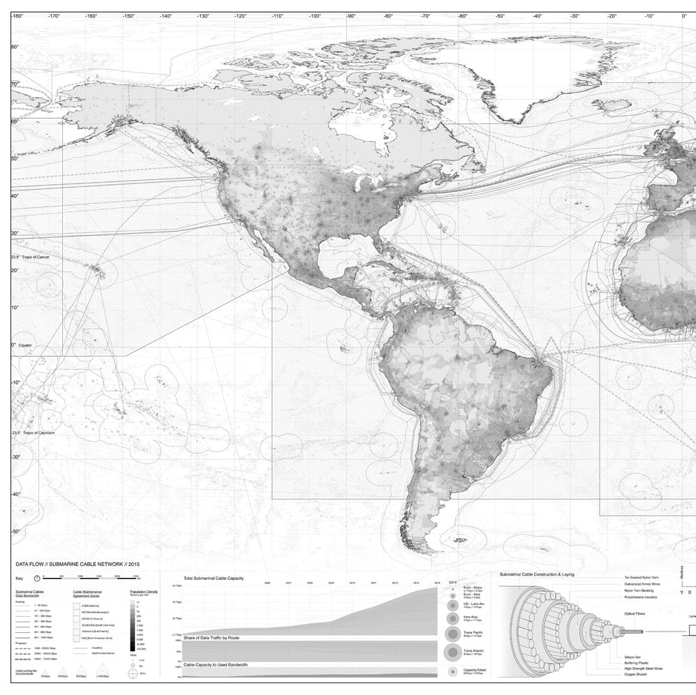
7 World Maps Pamphlet 36 will include seven world maps constructed on the basis of scientific and other sources of data to visualize political, economic and ecological ocean dynamics: World map of climate change risks World map of dredging operations World map of damage to coral reef systems World map of artificial islands World Map of illegal sand trade World map of telecommunications satellites and networks World map of mineral extraction and e-waste
8

9 Global submarine telecommunications cable networks

10 Simulation of wave motion acting on sand

11 Projects Pamphlet 36 will include five speculative, research driven design proposals for sites in the Maldives that make global material flows legible and adapt oceanic islands to their changing environment:s: Sand Bank Maldives E-waste Metal Exchange Male Sea Level Rise Toolkit Maafushi Island Climate Adaption Interface Funadhoo Island Resilience Strategy Male from Vilingili


12 Sand Bank Demand for sand, of the earth s resources now second only to fresh water, is threatening eco-systems, provoking violence, undermining good governance, and radically redistributing the earth s surface layer around the globe. The Sand Bank, taking advantage of local knowledge and the adjacency of the Maldives northern-most atoll, Ihavandihopolhu to the Indian Ocean s busiest trade route, utilizes the dynamic energies of the coral lagoon to intercept, stockpile and store sand for future use.


13 Maldives E-waste Metal Exchange This project proposes to expand Thilafushi, an island in the Maldives constructed entirely of trash, through the collection and processing of electronic waste. This looks to expose the dangers and hidden value of e-waste by producing a plastiglomerate land form and brokering its precious metals at an E-waste Metal Exchange in Male, thereby closing the global precious metal resource loop.


14 Male Sea Level Rise Toolkit At between 0.8 and 1.6m above sea level, Male, capital city of the Maldives, is extremely vulnerable to sea level rise according to IPCC predictions. This project proposes a datadriven analytical system to digitize and evaluate risk, value, adjacency and density, and infrastructural elements to enable the city to adapt to sea level rise by staying in place, but rising vertically.


15 Maafushi Island Climate Adaption Interface Senseables are devices that merge the self, the world, and data about one s place in the world. The Maldives currently ranks fourth in the world for mobile phone use per capita, with over two registered phones per person. This creates a vast pool for potential data collection. This project makes use of this high penetration of smart phones in the Maldives to create a citizen s mapping scheme that collects and maps island threats and local perceptions and knowledge. Sites at the base of telecommunications towers are repurposed to create computational data parks, to give social purpose to otherwise unused sites. The parks provide interfaces for development of adaption strategies to respond to climate change.

16 Funadhoo Island Resilience Strategy In response to predicted climate change risks, the Maldives government has developed a program of safe islands, which involves improving certain islands defenses through dredging and reclamation, while abandoning other islands to the sea. This project counters this with a proposal based on inhabitants attachment to their islands. It responds to sea level rise by careful mappings of risk, calibration of urban infrastructure with sea level rise and housing typologies that rise and fall with oceanic surges and tides.

17 Simulation of turbulence caused by dredging
Overview of proposed approach to the Desktop Study to inform discussion
 LTAS Phase 2: Climate Change Implications for the Human Settlements sector in South Africa Overview of proposed approach to the Desktop Study to inform discussion Project Team Project Lead: Crispian Olver
National Disaster Management Centre (NDMC) Republic of Maldives. Location
 Republic of Maldives. Location") National Disaster Management Centre (NDMC) Republic of Maldives Location Country Profile 1,190 islands. 198 Inhabited Islands. Total land area 300 sq km Islands range b/w 0.2 5 sq km Population approx.
National Disaster Management Centre (NDMC) Republic of Maldives Location Country Profile 1,190 islands. 198 Inhabited Islands. Total land area 300 sq km Islands range b/w 0.2 5 sq km Population approx.
3 rd Grade Social Studies Pacing Guide Arkansas Frameworks
 3 rd Grade Social Studies Pacing Guide Arkansas Frameworks 1st Nine Weeks Strand1: Geography Standard 1: Physical and Spatial Students shall develop an understanding of the physical and spatial characteristics
Perception of Earthquake Risk and Postdisaster
 Perception of Earthquake Risk and Postdisaster Reconstruction: Comparative Study of Two Residential Neighborhoods on Different Socio-economic Status in Tehran Seyed Ali Badri University of Tehran, sabadri@ut.ac.ir
Chapter 27. Bhutan, Maldives, Nepal, & Sri Lanka
 Chapter 27 Bhutan, Maldives, Nepal, & Sri Lanka Physical Geography of Bhutan, Maldives, Nepal & Sri Lanka Landforms Their locations on the fringe of South Asia means their physical and human geography
Locate places on contemporary maps using cardinal and intermediate directions, map scales, legends, and t
 Subject Grade Level 3 Social Studies G.1.3.1 G.1.3.10 G.1.3.11 G.1.3.12 G.1.3.13 G.1.3.14 G.1.3.15 G.1.3.2 G.1.3.3 G.1.3.4 G.1.3.5 G.1.3.6 G.1.3.7 G.1.3.8 G.1.3.9 Define absolute location Describe how
Pathways. Pathways through the Geography Major
 Pathways through the Major majors may structure their course selections around a sub-field of. Pathways are suggestions for classes in, in related disciplines, and skills training. Each pathway includes
2 nd Semester. Core Courses. C 2.1 City and Metropolitan Planning. Module 1: Urban Structure and Growth Implications
 2 nd Semester Core Courses C 2.1 City and Metropolitan Planning Module 1: Urban Structure and Growth Implications Growth of cities; cities as engine of growth; urban sprawl; land value, economic attributes
Commons and Climate Justice: Ecofeminist and Indigenous Paths
 Commons and Climate Justice: Ecofeminist and Indigenous Paths Patricia E. Perkins -- esperk@yorku.ca Faculty of Environmental Studies, York University, Toronto International Society for Ecological Economics
Rising Sea Levels: Time for Proactive Action in Florida and the Caribbean?
 Rising Sea Levels: Time for Proactive Action in Florida and the Caribbean? Dr. Alan Fyall and Dr. Thomas Wahl National Center for Integrated Coastal Research, University of Central Florida Dr. Roberta
Megacity Research Project TP. Ho Chi Minh Adaptation to Global Climate Change in Vietnam: Integrative Urban and Environmental Planning Framework
 1. Organization 2. Global Warming 3. Starting Phase 4. Results, Transdisciplinarity, Low-Rise High Density 5. Risk of Flooding 6. Partners 7. Action Field 1 8. Action Field 2 9. Urban Development Trends
USING 3D GIS TO ASSESS ENVIRONMENTAL FLOOD HAZARDS IN MINA
 King Fahd University of Petroleum & Minerals College of Environmental Design Geographical Information system USING 3D GIS TO ASSESS ENVIRONMENTAL FLOOD HAZARDS IN MINA Prepared by : Ali AL-Zahrani OUTLINE
Belfairs Academy GEOGRAPHY Fundamentals Map
 YEAR 12 Fundamentals Unit 1 Contemporary Urban Places Urbanisation Urbanisation and its importance in human affairs. Global patterns of urbanisation since 1945. Urbanisation, suburbanisation, counter-urbanisation,
MALDIVES. Regional Expert Workshop On Land Accounting For SDG Monitoring & Reporting (25-27 th Sept 2017) - Fathimath Shanna, Aishath Aniya -
 - Fathimath Shanna, Aishath Aniya -") MALDIVES Regional Expert Workshop On Land Accounting For SDG Monitoring & Reporting (25-27 th Sept 2017) - Fathimath Shanna, Aishath Aniya - ABOUT MALDIVES Approximately 860 km long and 120 km wide Consists
MALDIVES Regional Expert Workshop On Land Accounting For SDG Monitoring & Reporting (25-27 th Sept 2017) - Fathimath Shanna, Aishath Aniya - ABOUT MALDIVES Approximately 860 km long and 120 km wide Consists
LOUISIANA STUDENT STANDARDS FOR SOCIAL STUDIES THAT CORRELATE WITH A FIELD TRIP TO DESTREHAN PLANTATION KINDERGARTEN
 LOUISIANA STUDENT STANDARDS FOR SOCIAL STUDIES THAT CORRELATE WITH A FIELD TRIP TO DESTREHAN PLANTATION KINDERGARTEN Standard 2 Historical Thinking Skills Students distinguish between events, people, and
Social Studies Curriculum Document Grade 3 Alignment with Common Core Unit 1 Student Learning Expectation
 Social Studies Curriculum Document Grade 3 Alignment with Common Core Unit 1 Student Learning Enduring Understanding: Good citizenship should be evident by observing proper etiquette of the American flag.
Intimate Infrastructures
 Intimate Infrastructures A social and spatial strategy for high-density design at a human scale By Natasha Reid Intimate Infrastructures Intimate Infrastructures A social and spatial strategy for high-density
Indiana Academic Standards Science Grade: 3 - Adopted: 2016
 Main Criteria: Indiana Academic Standards Secondary Criteria: Subjects: Science, Social Studies Grade: 3 Correlation Options: Show Correlated Indiana Academic Standards Science Grade: 3 - Adopted: 2016
Global Atmospheric Circulation. Past climate change and natural causes. Global climate change and human activity
 GCSE Geography Edexcel B Revision Checklist Paper 1. Global Geographical Issues Topic 1. Hazardous Earth Key Idea I know/ understand The world s climate system Global Atmospheric Circulation Past climate
Rhode Island World-Class Standards Science Grade: K - Adopted: 2006
 Main Criteria: Rhode Island World-Class Standards Secondary Criteria: Subjects: Science, Social Studies Grade: K Correlation Options: Show Correlated Rhode Island World-Class Standards Science Grade: K
Geodesy. orientation. shape. gravity field
 Geodesy noun Science of measuring the shape, orientation and gravity field of the Earth and how it changes over time. shape orientation gravity field Positioning has always been important Downstream applications
Why I Am a Climate Realist. by Dr. Willem de Lange
 Why I Am a Climate Realist by Dr. Willem de Lange SPPI Commentary & Essay Series! May 27, 2009 Why I Am a Climate Realist by Dr. Willem de Lange May 23, 2009 In 1996 the United Nations Intergovernmental
Word Cards. 2 map. 1 geographic representation. a description or portrayal of the Earth or parts of the Earth. a visual representation of an area
 Name: Date: Hour: Word Cards 1 geographic representation a description or portrayal of the Earth or parts of the Earth Example: A map is a representation of an actual location or place. 2 map a visual
Of topic specific knowledge and understanding To encourage progressive development in 'thinking geographically'
 [August 2012] Content exemplars 1. Broad description of the content: Single paragraph, written with technical precision Content rigour (avoiding generic statements) Identifying the core of essential knowledge
Iceland and the Arctic: The Politics of Territoriality. Valur Ingimundaron Professor of Contemporary History, University of Iceland
 Iceland and the Arctic: The Politics of Territoriality Valur Ingimundaron Professor of Contemporary History, University of Iceland Drivers of Icelandic Arctic Policies Geostrategic Position Economic Interests
Main Criteria: Iowa Core Secondary Criteria: Virtual Field Trips Subjects: Science, Social Studies Grade: 4 Correlation Options: Show Correlated
 Main Criteria: Iowa Core Secondary Criteria: Subjects: Science, Social Studies Grade: 4 Correlation Options: Show Correlated Iowa Core Science Grade: 4 - Adopted: 2015 STRAND / COURSE IA.4-LS1. From Molecules
THE EFFECTS OF CLIMATE CHANGE ON THE TOURISM INDUSTRY IN SOUTHEAST ASIA WITH A SPECIFIC ANALYSIS OF THE CASE OF PATTAYA, THAILAND
 i THE EFFECTS OF CLIMATE CHANGE ON THE TOURISM INDUSTRY IN SOUTHEAST ASIA WITH A SPECIFIC ANALYSIS OF THE CASE OF PATTAYA, THAILAND Name School Course Date ii Abstract Climate change has already made an
Challenges of Urbanisation & Globalisation
 Challenges of Urbanisation & Globalisation Prepared by: Khairul Hisyam Kamarudin, PhD Feb 2016 Based on original lecture note by: Wan Nurul Mardiah Wan Mohd Rani, PhD URBANIZATION What is Urbanization?
Sustainable Development Goal 11 and the New Urban Agenda: can planning deliver? Vanessa Watson University of Cape Town 2016
 Sustainable Development Goal 11 and the New Urban Agenda: can planning deliver? Vanessa Watson University of Cape Town 2016 .to reinvigorate the global political commitment to the sustainable development
INTERNATIONAL INDIAN SCHOOL, RIYADH HALF YEARLY
 INTERNATIONAL INDIAN SCHOOL, RIYADH HALF YEARLY 2018-19 STD V Fill in the blanks: WORKSHEET LESSON - 1 KNOW YOUR PLANET SOCIAL STUDIES 1 A book containing maps is called an _ 2 A Flemish map maker, collection
Alleghany County Schools Curriculum Guide GRADE/COURSE: World Geography
 GRADE/COURSE: World 2013-14 GRADING PERIOD: 1 st Six Weeks Time Frame Unit/SOLs SOL # Strand Resource Assessment 8 days* The student will use maps, globes, satellite images, photographs, or diagrams to
(Emerging?) topics in resilience research perspectives from a critical urban and regional studies view
 topics in resilience research perspectives from a critical urban and regional studies view") (Emerging?) topics in resilience research perspectives from a critical urban and regional studies view Thilo Lang Head of Department Regional Geography of Europe Leibniz Institute for Regional Geography
(Emerging?) topics in resilience research perspectives from a critical urban and regional studies view Thilo Lang Head of Department Regional Geography of Europe Leibniz Institute for Regional Geography
IN Indiana Indiana Academic Standards
 IN Indiana Indiana Academic Standards Indiana Academic Standards for Grade 3 History Students describe how significant people, events and developments have shaped their own community and region; compare
Spatial Analysis of Natural Hazard and Climate Change Risks in Peri-Urban Expansion Areas of Dakar, Senegal
 1 Spatial Analysis of Natural Hazard and Climate Change Risks in Peri-Urban Expansion Areas of Dakar, Senegal URBAN WEEK 2009 BBL Preston Lounge Thursday, March 12, 2009 Christian Hoffmann GeoVille group
Climate Risk Visualization for Adaptation Planning and Emergency Response
 Climate Risk Visualization for Adaptation Planning and Emergency Response NCR Flood Fact Finding Workshop Ricardo Saavedra ricardo@vizonomy.com Social Media, Mobile, and Big Data St. Peter s Basilica,
Chapter 27. Bhutan, Maldives, Nepal, & Sri Lanka
 Chapter 27 Bhutan, Maldives, Nepal, & Sri Lanka Physical Geography of Bhutan, Maldives, Nepal & Sri Lanka Landforms Their locations on the fringe of South Asia means their physical and human geography
Geospatial natural disaster management
 Geospatial natural disaster management disasters happen. are you ready? Natural disasters can strike almost anywhere at any time, with no regard to a municipality s financial resources. These extraordinarily
Geospatial framework for monitoring SDGs/Sendai targets By Shimonti Paul Sr. Assistant Editor Geospatial Media & Communications
 Geospatial framework for monitoring SDGs/Sendai targets By Shimonti Paul Sr. Assistant Editor Geospatial Media & Communications Outline 1. Introduction to Geospatial Media and Communications 2. Geospatial
Department of Geography: Vivekananda College for Women. Barisha, Kolkata-8. Syllabus of Post graduate Course in Geography
 India: Regional Problems and Resource management Module 11 (Full Marks 50) Unit I: Region and Regionalisation 1.1 Various bases of regionalisation of India; problems of identification and delineation.
Topic 4: Changing cities
 Topic 4: Changing cities Overview of urban patterns and processes 4.1 Urbanisation is a global process a. Contrasting trends in urbanisation over the last 50 years in different parts of the world (developed,
Nursery. Reception. Year 1
 Nursery Geography Overview Autumn Spring Summer Notices detailed features of objects in their environment. Comments and asks questions about aspects of their familiar world such as the place where they
Graduate Courses Meteorology / Atmospheric Science UNC Charlotte
 Graduate Courses Meteorology / Atmospheric Science UNC Charlotte In order to inform prospective M.S. Earth Science students as to what graduate-level courses are offered across the broad disciplines of
Arizona Educator Proficiency Assessments (AEPA ) FIELD 04: GEOGRAPHY TEST OBJECTIVES
 FIELD 04: GEOGRAPHY TEST OBJECTIVES") Arizona Educator Proficiency Assessments (AEPA ) TEST OBJECTIVES Subarea Range of Objectives Approximate Test Proportions I. Geographic Concepts and Skills 1 6 25% II. World Geography 7 14 34% III. United
Arizona Educator Proficiency Assessments (AEPA ) TEST OBJECTIVES Subarea Range of Objectives Approximate Test Proportions I. Geographic Concepts and Skills 1 6 25% II. World Geography 7 14 34% III. United
A Correlation of. Pearson myworld Social Studies We Are Connected to the
 A Correlation of Pearson myworld Social Studies We Are Connected 2013 Standard 2-1: The student will demonstrate an understanding of the local community as well as the fact that geography influences not
The European Union and its Overseas Entities
 The European Union and its Overseas Entities Strategies in the face of climate change and biodiversity loss Reunion Island, 07-11 July 2008 An official event under the EU French Presidency International
Sample. Contents SECTION 1: PLACE NAMES 6 SECTION 2: CONNECTING TO PLACES 21 SECTION 3: SPACES: NEAR AND FAR 53
 Contents Teachers' Notes 4 National Curriculum Links 5 SECTION 1: PLACE NAMES 6 Teachers' Notes 7-8 Activities Names Of Places 9 Place Names Are Important 1 10 Place Names Are Important 2 11 The Meanings
COURSE OUTLINE. GEO 101 Geography 3 Course Number Course Title Credits. Reference Liberal Arts Division Book List
 MERCER COUNTY COMMUNITY COLLEGE LIBERAL ARTS DIVISION COURSE OUTLINE GEO 101 Geography 3 Course Number Course Title Credits Required Materials: Catalog Description: Reference Liberal Arts Division Book
Activity 2.2: Recognizing Change (Observation vs. Inference)
") Activity 2.2: Recognizing Change (Observation vs. Inference) Teacher Notes: Evidence for Climate Change PowerPoint Slide 1 Slide 2 Introduction Image 1 (Namib Desert, Namibia) The sun is on the horizon
Activity 2.2: Recognizing Change (Observation vs. Inference) Teacher Notes: Evidence for Climate Change PowerPoint Slide 1 Slide 2 Introduction Image 1 (Namib Desert, Namibia) The sun is on the horizon
Current and future climate of Vanuatu. Pacific-Australia Climate Change Science and Adaptation Planning Program
 Pacific-Australia Climate Change Science and Adaptation Planning Program Hiu Torres Islands Vanua Lava Gaua Banks Islands Espiritu Santo Malekula Ambae Épi Maéwo Pentecost Ambrym Shepherd Islands Éfate
DESCRIPTION ACADEMIC STANDARDS INSTRUCTIONAL GOALS VOCABULARY. Subject Area: Geography
 DESCRIPTION Middle America is a cultural crossroads. African, Native American, and European influences are seen in its religions, foods, architecture, languages, and arts. Includes discussion of terrains
Introduction to GIS. Dr. M.S. Ganesh Prasad
 Introduction to GIS Dr. M.S. Ganesh Prasad Department of Civil Engineering The National Institute of Engineering, MYSORE ganeshprasad.nie@gmail.com 9449153758 Geographic Information System (GIS) Information
4th Grade Social Studies GLEs
 4th Grade Social Studies GLEs Geography The World in Spatial Terms 1. Interpret different kinds of maps using a map key/legend, compass rose, cardinal and intermediate directions, and distance scale (G-1A-E1)
PYP of the IB: Program of Inquiry. An inquiry into: An inquiry into How we express ourselves. An inquiry into How the world works
 PYP of the IB: Program of Inquiry School: Center for Inquiry at School #2 2010-2011 : Age the nature of orientation in and time; personal the the ways in the natural the the rights K Safe and Healthy Central
How Will Melting Ice Sheets Affect Us?
 PASSAGE 4 How Will Melting Ice Sheets Affect Us? Variation is normal. During the last ice age, for example, ice sheets also covered much of North America and Scandinavia. Why is what s happening now different
Tropical Revolving Storms: Cuba 2008 By The British Geographer
 Place Context Tropical Revolving Storms: Cuba 2008 By The British Geographer The Republic of Cuba is located in the northern tropics with in island chain of the Caribbean. It is made up of one large Island,
Current and future climate of the Cook Islands. Pacific-Australia Climate Change Science and Adaptation Planning Program
 Pacific-Australia Climate Change Science and Adaptation Planning Program Penrhyn Pukapuka Nassau Suwarrow Rakahanga Manihiki N o r t h e r n C o o k I s l a nds S o u t h e Palmerston r n C o o k I s l
Beyond control: agricultural heritage and the Anthropocene
 Beyond control: agricultural heritage and the Anthropocene Daniel Niles Research Institute for Humanity and Nature Kyoto Japan RIHN/UC Berkeley International Workshop Food, Agriculture and Human Impacts
Louisiana Academic Standards Science Grade: 4 - Adopted: 2017
 Main Criteria: Louisiana Academic Standards Secondary Criteria: Subjects: Science, Social Studies Grade: 4 Correlation Options: Show Correlated Louisiana Academic Standards Science Grade: 4 - Adopted:
Dutch spatial planning: from implicit to explicit sustainable urban development
 Dutch spatial planning: from implicit to explicit sustainable urban development Jan Goedman (VROM*) Wim Heiko Houtsma (VROM) Wil Zonneveld (Delft University) *Dutch Ministry of Housing, Spatial Planning
The Local Community and Regional Communities
 GRADE 3 The Local Community and Regional Communities Subject/Course 0470 Level 3 Through active learning experiences, third grade students gain knowledge and process information about their local community
Salem Coastal Vulnerability. By: Ariabel Adames, Abby Jackson, Mariluz Ayala, Mikara Crowley, Karley Skutul
 Salem Coastal Vulnerability By: Ariabel Adames, Abby Jackson, Mariluz Ayala, Mikara Crowley, Karley Skutul Total Population: 42,544 Sea level Rise: 10,700 Worst Case Storm Surge: 22,560 Minority Income
Moreton Bay and Key Geographic Concepts Worksheet
 Moreton Bay and Key Geographic Concepts Worksheet The Australian Curriculum: Geography draws on seven key geographic concepts: place scale space environment change interconnection sustainability They are
Geography Skills Progression. Eden Park Primary School Academy
 Geography Skills Progression Eden Park Primary School Academy In order to ensure broad and balanced coverage, we follow these principles: Within each phase, geography is a driver for at least 3 Learning
Montana Content Standards Science Grade: 6 - Adopted: 2016
 Main Criteria: Montana Content Standards Secondary Criteria: Subjects: Science, Social Studies Grade: 6 Correlation Options: Show Correlated MT.6-8.PS. BENCHMARK / STANDARD 6-8.PS.3. MT.6-8.LS. BENCHMARK
Abstract of Dissertation
 Abstract of Dissertation A Study on Place Identity of Urbanized Agriculture based Settleme nt Process of Change and Transformation in Urban Village in Hanoi The world is in the midst of the phase of globalization,
C o n c e p t > C a l m T e c h n o l o g y
 U R B A N I S L A N D S v o l 1 : C U T T I N G S J A K O V I C H [ e d ] D e e p s u r f a c e - I n f r a s t r u c t u r a l / S t r u c t u r a l s k i n 32 03 jellyfish house L i s a I wa m o to +
Transition factors analysis of human settlement
 The Sustainable City VI 53 Transition factors analysis of human settlement S.-T. Kuo & Ch.-J. Chen Graduate Institute of Urban Development and Architecture, National University of Kaohsiung, Taiwan Abstract
GGY 301: Research Methods
 GGY 301: Research Methods Course No GGY 301 Course Title Research Methods Core/Optional Core for Special Degree :This course provides students with a basic knowledge and understanding of the research methodology
4th Grade US Regional Geography First Nine Weeks
 4th Grade US Regional Geography First Nine Weeks 2014-2015 Identify the choice that best completes the statement or answers the question. 1 The line identified as 0 runs west and east on the globe and
Applications on Slope Land Management through GIS Technology
 Applications on Slope Land Management through GIS Technology Hsiu-Yi Ko, Jo-Yu Liu,Tai-Chung Hsiao, Tian-Ying Chou, Ying-Hui Chang Geographic Information Systems Research Center of Feng Chia University
Future Sea Level Rise and its Implications for SIDS and LDCs
 Future Sea Level Rise and its Implications for SIDS and LDCs Bill Hare, Michiel Schaeffer, Mahé Perrette, Matthias Mengel COP17, Durban, 2 nd December Overview Part 1: Global sea level: past and future
Geography Mile Post 1
 Mile Post 1 Use world maps, atlases and globes to identify the UK and its countries, as well as the countries, continents and oceans studied at this key stage Key Skills IPC learning Goals 1.11 Be able
Academic Standards for Geography
 Academic Standards for June 1, 2009 FINAL Elementary Standards Grades 3-8 Pennsylvania Department of Education These standards are offered as a voluntary resource for Pennsylvania s schools and await action
Enquiry question: How does the world s climate system function, why does it change and how can this be hazardous for people?
 Content Topic 1: Hazardous Earth Enquiry question: How does the world s climate system function, why does it change and how can this be hazardous for people? 1.1 The atmosphere operates as a global system
Class 4J Autumn Term St. Lucia Adapted from QCA Geography Unit 10 incorporating some elements of Unit 25
 Class 4J Autumn Term 2002 Geography St. Lucia Geography Unit 10 incorporating some elements of Unit 25 ABOUT THE UNIT In this unit children develop ideas about a less economically developed country. When
Creating an Illustrated Map: New Zealand
 S T U D E N T H A N D O U T A Creating an Illustrated Map: New Zealand You will work in a group of four to create an illustrated map of one type of Pacific island: a continental island. Your illustrated
Learning Target : Describe the purposes and uses of different types of maps.
 Learning Target : Describe the purposes and uses of different types of maps. Directions: 1. Below, place a where you think you are located. 2. In which continent are you located? 3. In which country are
Mediterranean Sea and Territorial Development, Opportunities and Risks
 EESC Hearing Towards an EU Macro-Regional Strategy for the Mediterranean Mediterranean Sea and Territorial Development, Opportunities and Risks Michaela Gensheimer Structure of Intervention Part I: What
New York State Learning Standards and Core Curriculum Science Grade: 3 - Adopted: Interdependent Relationships in Ecosystems
 Main Criteria: New York State Learning Standards and Core Curriculum Secondary Criteria: Subjects: Science, Social Studies Grade: 3 Correlation Options: Show Correlated New York State Learning Standards
Level 1 Geography PROGRAMME OVERVIEW 2014
 Ruawai College Social Sciences Department Level 1 Geography PROGRAMME OVERVIEW 2014 Topic/Theme EXTREME NATURAL EVENTS: TSUNAMIS Case Study: 2004 Indian Ocean Tsunami/Boxin g Day Tsunami, Indian Ocean
The Geography Curriculum at Coston Primary
 The Geography Curriculum at Coston Primary Years Year 1 Year 2 Summer We are learning about where food is farmed and in The physical features of farms. The human features of farms. The characteristics
Peoples, Places and Cultures in Africa, Asia and the Southwest Pacific
 GRADE 7 Peoples, Places and Cultures in Africa, Asia and the Southwest Pacific Course 0470-07 Students in seventh grade explore the history, geography, government, economic systems, current issues, and
Disaster Management & Recovery Framework: The Surveyors Response
 Disaster Management & Recovery Framework: The Surveyors Response Greg Scott Inter-Regional Advisor Global Geospatial Information Management United Nations Statistics Division Department of Economic and
Simple Solutions Social Studies Level 2. Level 2. Social Studies. Help Pages
 Level 2 Social Studies 147 148 adobe houses with bricks made of clay and straw ancestor a family member who lived before us appoint choose; leaders can appoint others barter trading one thing for another
SCIENCE OF TSUNAMI HAZARDS
 SCIENCE OF TSUNAMI HAZARDS ISSN 8755-6839 Journal of Tsunami Society International Volume 29 Number 3 2010 POTENTIAL DEFICIENCIES IN EDUCATION, INSTRUMENTATION, AND WARNINGS FOR LOCALLY GENERATED TSUNAMIS
Geography. Programme of study for key stage 3 and attainment target (This is an extract from The National Curriculum 2007)
") Geography Programme of study for key stage 3 and attainment target (This is an extract from The National Curriculum 2007) Crown copyright 2007 Qualifications and Curriculum Authority 2007 Curriculum aims
Geography Programme of study for key stage 3 and attainment target (This is an extract from The National Curriculum 2007) Crown copyright 2007 Qualifications and Curriculum Authority 2007 Curriculum aims
St John s Catholic Primary School. Geography Policy. Mission Statement
 St John s Catholic Primary School Geography Policy Mission Statement We at St John s strive for excellence in education by providing a safe, secure and caring family environment where individuals are valued
THE 3D SIMULATION INFORMATION SYSTEM FOR ASSESSING THE FLOODING LOST IN KEELUNG RIVER BASIN
 THE 3D SIMULATION INFORMATION SYSTEM FOR ASSESSING THE FLOODING LOST IN KEELUNG RIVER BASIN Kuo-Chung Wen *, Tsung-Hsing Huang ** * Associate Professor, Chinese Culture University, Taipei **Master, Chinese
INDIANA ACADEMIC STANDARDS FOR SOCIAL STUDIES, WORLD GEOGRAPHY. PAGE(S) WHERE TAUGHT (If submission is not a book, cite appropriate location(s))
 WHERE TAUGHT (If submission is not a book, cite appropriate location(s))") Prentice Hall: The Cultural Landscape, An Introduction to Human Geography 2002 Indiana Academic Standards for Social Studies, World Geography (Grades 9-12) STANDARD 1: THE WORLD IN SPATIAL TERMS Students
Prentice Hall: The Cultural Landscape, An Introduction to Human Geography 2002 Indiana Academic Standards for Social Studies, World Geography (Grades 9-12) STANDARD 1: THE WORLD IN SPATIAL TERMS Students
2014 Breaks Heat Record, Challenging Global Warming Skeptics - NYT...
 1 of 4 1/20/2015 8:48 PM Last year was the hottest on earth since record-keeping began in 1880, scientists reported on Friday, underscoring warnings about the risks of runaway greenhouse gas emissions
M14/3/GEOGR/SP2/ENG/TZ0/XX/Q GEOGRAPHY STANDARD LEVEL PAPER 2. Monday 19 May 2014 (morning) 1 hour 20 minutes INSTRUCTIONS TO CANDIDATES
 1 hour 20 minutes INSTRUCTIONS TO CANDIDATES") M14/3/GEOGR/SP2/ENG/TZ0/XX/Q 22145203 GEOGRAPHY STANDARD LEVEL PAPER 2 Monday 19 May 2014 (morning) 1 hour 20 minutes INSTRUCTIONS TO CANDIDATES Do not open this examination paper until instructed to do
M14/3/GEOGR/SP2/ENG/TZ0/XX/Q 22145203 GEOGRAPHY STANDARD LEVEL PAPER 2 Monday 19 May 2014 (morning) 1 hour 20 minutes INSTRUCTIONS TO CANDIDATES Do not open this examination paper until instructed to do
Geographical knowledge and understanding scope and sequence: Foundation to Year 10
 Geographical knowledge and understanding scope and sequence: Foundation to Year 10 Foundation Year 1 Year 2 Year 3 Year 4 Year 5 Year 6 Year level focus People live in places Places have distinctive features
Tackling urban sprawl: towards a compact model of cities? David Ludlow University of the West of England (UWE) 19 June 2014
 19 June 2014") Tackling urban sprawl: towards a compact model of cities? David Ludlow University of the West of England (UWE) 19 June 2014 Impacts on Natural & Protected Areas why sprawl matters? Sprawl creates environmental,
Tackling urban sprawl: towards a compact model of cities? David Ludlow University of the West of England (UWE) 19 June 2014 Impacts on Natural & Protected Areas why sprawl matters? Sprawl creates environmental,
Chapter 21 Southwest Asia: Harsh & Arid Lands
 Name Hour Chapter 21 Southwest Asia: Harsh & Arid Lands Essential Question: How has the physical geography of Asia influenced the development of these regions (i.e. history, population distribution, &
Grade 7 Social Studies
 Standard 1: History Students will examine the major movements, events, and figures that contributed to the development of nations in modern Africa, Asia, and the Southwest Pacific from acient civilizations
The Spatial Perspective
 Department of Geography University of California at Santa Barbara GEOGRAPHY 5 MIDTERM REVIEW SHEET The Spatial Perspective - Review all of chapter 1 carefully except for Box 1.B (but do review Box 1.A
Programs Aligned With: Kindergarten Social Studies
 Programs Aligned With: Kindergarten Social Studies Progressive Waste Solutions K.2.1 Compare and contrast children and families today with those in the past using various sources K.3.2 Identify maps and
Table of Contents. Introduction 4. Chapter 1 Research and the Deep Oceans 6. Chapter 2 Physical Characteristics of the Ocean 10
 Table of Contents Introduction 4 Chapter 1 Research and the Deep Oceans 6 Chapter 2 Physical Characteristics of the Ocean 10 Chapter 3 Composition of the Oceans Waters 16 Chapter 4 Tides, Waves, and Currents
A science-policy approach towards local adaptation planning: The case of Santiago de Chile
 A science-policy approach towards local adaptation planning: The case of Santiago de Chile Kerstin Krellenberg, PhD Resilient Cities 2011 2nd World Congress on Cities and Adaptation to Climate Change Bonn,
Urbanization and Sustainable Development of Cities: A Ready Engine to Promote Economic Growth and Cooperation
 Urbanization and Sustainable Development of Cities: A Ready Engine to Promote Economic Growth and Cooperation Wan Portia Hamzah Institute of Strategic and International Studies (ISIS) Malaysia 10 September