NSW MINING Health, Safety, Environment & Community
|
|
|
- Regina Young
- 5 years ago
- Views:
Transcription


1 NSW MINING Health, Safety, Environment & Community
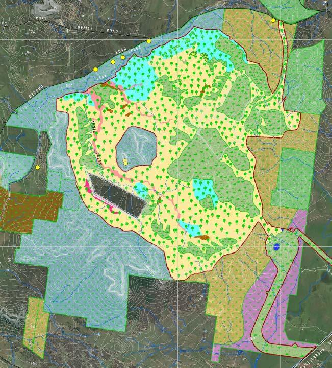
2 Developing Natural Landform in Mine Overburden Rehabilitation Tasman Willis Land Management Officer Mangoola Open Cut - Glencore
3 Developing Natural Landform in Mine Overburden Rehabilitation Background Initial Work Natural Landform Model Final Landform Mine Planning Rainfall and Erosion Revegetation and Habitat Structures


4 Background This presentation aims to discuss the process of implementing a natural landform in mine rehabilitation at Mangoola Open Cut Mangoola Open Cut coal mine operating since 2010, rehabilitation commenced in October 2011.


5 Background Greenfield site surrounded by undulating hills. Hunter River to the south-east, escarpment generally to the south and west. The approved mining area is undulating hills between the Hunter River and Wybong Creek.

6 Background Original approved landform for North Pit 2010 Opportunity was identified to develop rehabilitation that would be more suited to fit into the surrounding undulating landform
 in 2012.")

7 Initial Work The first stages of natural landform was developed by Mangoola mining engineers over 9 ha (not Geofluv) in Natural landform was not a consent condition, this was internally recognised as a positive and management committed to any additional costs and time associated with the trial.
 - Geofluv.")
8 Natural Landform Model 1300ha project area, work undertaken externally (Umwelt/Jacobs) The modelling program selected for this project was Natural Regrade (Carlson Software) - Geofluv. Approximate mining Boundary Pre-mining landscape, facing south
9 Data Collection The process of developing the natural landform design includes: 1.Testing of material to understand erosion and infiltration rates; 2.Evaluate characteristics of existing drainage lines; 3.Blend ridges and creek alignments in with the surrounds; 4.Run the model using the Natural Regrade (Geofluv) software; and 5.Generation of suitable dxf file for use with mine design software.
10 Mine Rehabilitation Landform Model Output for Mining Engineers, facing south-east

11 Mine Rehabilitation Landform Final output from Model video files

12 Mine Rehabilitation Landform The output was more detailed than expected. Detail included modelling creek bank designs for all creeks and drainage lines. Recent MOP (REMP) plans were all developed using this natural landform model. The output was provided to the Mine Engineers.
13 Mine Planning Mining engineers plan ten metre lifts, due to the size of our machines and dump lift heights. This also allows less material pushed and more detail landform shaping.

14 Mine Planning Ramp and dump strategies were established in the preliminary stages of developing the model and therefore achieving the final landscape did not interfere with the progression of the dump.

15 Mine Rehabilitation Landform


16 Mine Rehabilitation Landform Seeded March 2014, Photo August 2015


17 Mine Planning
18 Rainfall November 2013 to July 2015


19 Erosion and Remediation Main erosion issues have been the result of: Overflow from mining area as mine progresses upslope of the rehabilitation. Rip lines not occurring level across contour. Vehicle access across rip lines. July 2013 July 2015 July 2015


20 Revegetation and Habitat Structure After the landform is shaped, the areas are strategically targeted for specific vegetation types that occur in the surrounding local area, based on similar topography, slope, aspect and topsoil type. Only species that occur in the local area are used in rehabilitation. Habitat structures are established including, wood piles, rock piles, standing habitat trees, low areas of inundation and dams. Nest boxes will be installed over time as the vegetation provides appropriate habitat.

21 Determining Vegetation Communities


22 Establishing Vegetation Communities Grey Box-Ironbark Woodland Slaty Box Woodland


23 Mine Rehabilitation Vegetation Growth January 2012 May 2014 July 2015 March 2013 May 2014 July 2015


24 Contributions The project was a whole of mine effort involving mine employees, local contractors and consultants. Significant input was provided by the Mining Engineers, Production Department and Environment and Community Representatives. Thanks Everyone: Umwelt/Jacobs natural landform design Subzero final trim/topsoil application/habitat structures Future Harvest seed collection and application

25 Any Questions
26 NSW MINING Health, Safety, Environment & Community
Duralie Open Pit Modification
 Duralie Open Pit Modification Environmental Assessment SECTION 5 REHABILITATION STRATEGY TABLE OF CONTENTS 5 REHABILITATION STRATEGY 5-1 5.1 EXISTING DCM REHABILITATION 5-1 5.1.1 Rehabilitation Principles
6 MACRAES MINING PROJECT MINERAL ZONE
 6 MACRAES MINING PROJECT MINERAL ZONE 6.1 ZONE STATEMENT The Macraes Mining Zone applies to the area of land controlled by Macraes Mining Limited and included in Mining Permit 41-064 at the date of public
SLOPE PROCESSES, LANDSLIDES, AND SUBSIDENCE
 CHAPTER 9 SLOPE PROCESSES, LANDSLIDES, AND SUBSIDENCE La Conchita slide January 10, 2005 Triggered by heavy rainfall, reactivation along an older landslide surface (35,000 years ago, 6000 years ago, and
Nipigon River Landslide, Ontario, Canada
 Nipigon River Landslide, Ontario, Canada A. Abdelaziz, S. Besner, R. Boger, B. Fu, J. Deng, and A. Farina Presenter: Jian Deng, Ph.D, P.Eng Centre of Excellence for Sustainable Mining and Exploration,
Batu Hijau Mine Closure Cost Estimation 1
 APPENDIX 1 Batu Hijau Mine Closure Cost Estimation 1 1. MINE INFRASTRUCTURE 1.1 Process Plant / Mill 1.2 Main Workshop Area 1.3 Material Handling Systems Rail Line and Loop 1.4 Admin Buildings 1. 5 Ro
ENVIRONMENTAL ASSESSMENT
 ENVIRONMENTAL ASSESSMENT Duralie Extension Project SECTION 5 REHABILITATION GLOUCESTER COAL TABLE OF CONTENTS 5 REHABILITATION 5-5. REHABILITATION STRATEGY AND GOALS 5-5.. Existing Duralie Coal Mine Rehabilitation
9/13/2011 CHAPTER 9 AND SUBSIDENCE. Case History: La Conchita Landslide. Introduction
 CHAPTER 9 SLOPE PROCESSES, LANDSLIDES, AND SUBSIDENCE Case History: La Conchita Landslide La Conchita: small coastal community 80 km (50 mi) northwest of Los Angeles Landslide occurred on January 10, 2005
1.0 PURPOSE AND FORMAT OF THE FINAL EIR
 1.0 PURPOSE AND FORMAT OF THE FINAL EIR 1.1 PROJECT OVERVIEW CEMEX (RMC Pacific Materials, dba CEMEX) operates the Bonny Doon Shale and Limestone Quarries in Santa Cruz County for the production of Portland
Orica Australia Pty Ltd Ammonium Nitrate Facility Upgrade
 Orica Australia Pty Ltd Ammonium Nitrate Facility Upgrade January 2010 Revision 0 Contents 1. Introduction 1 1.1 Purpose 1 1.2 Objectives 1 1.3 Relevant Environmental Legislation, Guidelines and Policies
Science EOG Review: Landforms
 Mathematician Science EOG Review: Landforms Vocabulary Definition Term canyon deep, large, V- shaped valley formed by a river over millions of years of erosion; sometimes called gorges (example: Linville
Independent Environmental Audit Erosion and Sediment Control
 Independent Environmental Audit Erosion and Sediment Control Commencement of YOUNG TO BETHUNGRA LOOPING PIPELINE JUNE 2016 suite 1, 39 fitzmaurice st (po box 5464) wagga wagga nsw 2650 australia t (02)
Appendix Z. Groundwater Assessment Supplementary Report. Document Name i Insert Month/Year
 Appendix Z Groundwater Assessment Supplementary Report Document Name i Insert Month/Year Australasian Groundwater and Environmental Consultants Pty Ltd Level 2 / 15 Mallon Street Bowen Hills, QLD 4006
Central Queensland Coal Project Appendix 4b Geotechnical Assessment. Environmental Impact Statement
 Central Queensland Coal Project Appendix 4b Geotechnical Assessment Environmental Impact Statement GEOTECHNICAL ASSESSMENT OF OPEN CUT MINING ADJACENT TO THE BRUCE HIGHWAY, CENTRAL QUEENSLAND COAL PROJECT
1. PROJECT BACKGROUND. July 18, Alberta Infrastructure & Transportation Central Region #401, Street Red Deer, Alberta T4N 6K8
 July 18, 2005 Alberta Infrastructure & Transportation Central Region #401, 4902 51 Street Red Deer, Alberta T4N 6K8 Mr. Alain Momedi, P.Eng. Project Engineer Dear Mr. Momedi: H11:04 km 11.1 Erosion along
Tom Blackman Project Lead. Mékell Mikell Communications Representative
 Sediment Cleanup Middle River Complex, 2016-17 Season 1 Project Photo Tour Updated November 15, 2016 Tom Blackman Project Lead Mékell Mikell Communications Representative 1 Sediment Cleanup - Season 1
Operative Chapter 13 Natural Hazards 31 January 2015 NATURAL HAZARDS
 CHAPTER 13: NATURAL HAZARDS 13.0 INTRODUCTION Natural hazards have the potential to damage property, infrastructure and ecosystems, and threaten health and safety. Remedying the damage can cost individuals
Rocks, Minerals, & Mining. (I ain t sayin she a golddigga)
") Rocks, Minerals, & Mining (I ain t sayin she a golddigga) The Rock Cycle! Rocks are made up of multiple minerals. Minerals are made up of multiple elements. Rocks and minerals recycle or change due to
Rocks, Minerals, & Mining (I ain t sayin she a golddigga) The Rock Cycle! Rocks are made up of multiple minerals. Minerals are made up of multiple elements. Rocks and minerals recycle or change due to
soil assessment and management planning for CSG projects
 Use of historical soils information for soil assessment and management planning for CSG projects Cameron Traill 1, Greg Holz 2, Alex Kochnieff 3, Sarah de Man 4, Adam Christison 5 1 WorleyParsons Services,
Early Exploration Plan Activity Information
 Early Exploration Plan Activity Information Activities That Require an Early Exploration Plan: Line cutting that is a width of 1.5 metres or less; Geophysical surveys on the ground requiring the use of
Track design and management
 1 Track design and management Peter Fogarty, Certified Professional Soil Scientist NSW Soil Knowledge Network Cooma, June 18, 2018 Acknowledgements Antia Brademann, Cooma Waterwatch, Organiser Jo Powells,
Automatic Change Detection from Remote Sensing Stereo Image for Large Surface Coal Mining Area
 doi: 10.14355/fiee.2016.05.003 Automatic Change Detection from Remote Sensing Stereo Image for Large Surface Coal Mining Area Feifei Zhao 1, Nisha Bao 2, Baoying Ye 3, Sizhuo Wang 4, Xiaocui Liu 5, Jianyan
GIS data classes used within the November 2013 Environmental Statement Engineering Maps
 LWM-HS2-EN-DAT-000-000001 P01 22 January 2014 GIS data classes used within the November 2013 Environmental Statement Engineering Maps Document No.:LWM-HS2-EN-DAT-000-000001 Revision Author Checked by Approved
Use of Bioengineering Techniques for Revegetation of Riparian Areas: Colomac Mine Remediation Project, NWT
 Use of Bioengineering Techniques for Revegetation of Riparian Areas: Colomac Mine Remediation Project, NWT McPherson, M. 1, Vanderspiegel, R. 2, Breadmore, R. 2, and Hewitt, M. 3 2012 RPIC Federal Contaminated
L OWER N OOKSACK R IVER P ROJECT: A LTERNATIVES A NALYSIS A PPENDIX A: H YDRAULIC M ODELING. PREPARED BY: LandC, etc, LLC
 L OWER N OOKSACK R IVER P ROJECT: A LTERNATIVES A NALYSIS A PPENDIX A: H YDRAULIC M ODELING PREPARED BY: LandC, etc, LLC TABLE OF CONTENTS 1 Introduction... 1 2 Methods... 1 2.1 Hydraulic Model... 1 2.2
Long Valley Meadow Restoration Project
 Long Valley Meadow Restoration Project USDA Forest Service Mogollon Rim Ranger District Coconino National Forest Coconino County, Arizona T13N, R9E, Section 12 and T13N, R10E, Sections 6 and 7 Gila and
WEIR INTERNATIONAL, INC. Mining, Geology and Energy Consultants
 WEIR INTERNATIONAL, INC. Mining, Geology and Energy Consultants Introduction to Coal Mining History of Coal in the United States Coal was one of man s earliest sources of heat and light Coal was first
Trainee Manual C02 CITY OF SASKATOON. Water and Sewer Section. Severe Storm Response Trainee Manual. Version # 1-0-3
 Trainee Manual C02 CITY OF SASKATOON Water and Sewer Section Severe Storm Response Trainee Manual CITY OF SASKATOON Severe Storm Response Trainee Manual City of Saskatoon Severe Storm Response Trainees
This report was prepared by Klohn Crippen Consultants Ltd. for Alberta Transportation Central Region under Contract No. CE053/2000.
 Alberta Transportation Central Region #401, 4902 51 Street Red Deer, Alberta T4N 6K8 June 7, 2002 Mr. Melvin Mayfield, P.Eng. Project Engineer Dear Mr. Mayfield: Central Region Landslide Assessment Site
Continuing Education Associated with Maintaining CPESC and CESSWI Certification
 Continuing Education Associated with Maintaining CPESC and CESSWI Certification Module 2: Stormwater Management Principles for Earth Disturbing Activities Sponsors: ODOTs Local Technical Assistance Program
Remedial Program. GE Hudson Falls Plant Site. GE Hudson Falls Plant Site. TDCS Status
 Updates on Remedial Programs at the GE Hudson Falls Plant Site and GE Fort Edward Plant Site GE Hudson Falls USEPA Community Advisory Group Meeting September 11, 2008 GE Fort Edward Division of Environmental
Changes in Texas Ecoregions Copy the questions and answers
 Changes in Texas Ecoregions Copy the questions and answers 1. What are some kinds of damage that hurricanes cause? Roads and bridges might be washed away. Trees and power lines can be knocked down. Area
DESIGN OF WASTE DUMPS WITH FLOW-THROUGH ROCK DRAINS by Peter C. Lighthall, C. David Sellars, and W.D. Burton ABSTRACT
 ABSTRACT DESIGN OF WASTE DUMPS WITH FLOW-THROUGH ROCK DRAINS by Peter C. Lighthall, C. David Sellars, and W.D. Burton A number of mines in mountainous regions of British Columbia are being forced by topographic
Low Gradient Velocity Control Short Term Steep Gradient Channel Lining Medium-Long Term Outlet Control Soil Treatment Permanent [1]
![Low Gradient Velocity Control Short Term Steep Gradient Channel Lining Medium-Long Term Outlet Control Soil Treatment Permanent [1]](/thumbs/87/96478185.jpg "Low Gradient Velocity Control Short Term Steep Gradient Channel Lining Medium-Long Term Outlet Control Soil Treatment Permanent [1]") Rock Linings DRAINAGE CONTROL TECHNIQUE Low Gradient Velocity Control Short Term Steep Gradient Channel Lining Medium-Long Term Outlet Control Soil Treatment Permanent [1] [1] The design of permanent installations
Rock Linings DRAINAGE CONTROL TECHNIQUE Low Gradient Velocity Control Short Term Steep Gradient Channel Lining Medium-Long Term Outlet Control Soil Treatment Permanent [1] [1] The design of permanent installations
The effects of forest in controlling gully erosion
 Erosion, Debris Flows and Environment in Mountain Regions (Proceedings of the Chengdu Symposium, July 1992). IAHS Publ. no. 209, 1992. 429 The effects of forest in controlling gully erosion LI ZHUO Xifeng
REVEGETATION AND REGENERATION
 9 REVEGETATION AND REGENERATION The scale of the revegetation and regeneration management program across the Bundanon Trust properties is defined as a catchment landscape scale project. All facets of habitat
Early Exploration Permit Activity Information
 Early Exploration Permit Activity Information Activities That Require an Early Exploration Permit: Line cutting that is a width greater than 1.5 metres Mechanized stripping of a total surface area of greater
Changes in Texas Ecoregions
 Comment On Lesson Changes in Texas Ecoregions The state of Texas can be divided into 10 distinct areas based on unique combinations of vegetation, topography, landforms, wildlife, soil, rock, climate,
SOIL INFORMATION FOR PUMPED WATER STORAGE SCHEME, STEELPOORT VALLEY
 REPORT On contract research for Bohlweki Environmental SOIL INFORMATION FOR PUMPED WATER STORAGE SCHEME, STEELPOORT VALLEY February 2007 By D.G. Paterson ARC-Institute for Soil, Climate and Water, Private
Bipole III Transmission Project Construction Environmental Protection Plan Construction Section N2 Environmentally Sensitive Site Locations Map 81
 ± DOCUMENT PATH: G :\_GIS_PROJECT_FOLDER\00_HYDRO\111440054_BPIII_EPP\ARCMAP\ESS_N2\BPIII_CENVPP_N1N2N3N4C1SECTIONBASEMAP_MAPBOOK_BTB_STANTEC_20131201.MXD 196 Coordinate System: UTM Zone NAD83 Data Source:
Why study physical features? How does it help me during the course of studying Geography Elective?
 (b) Physical features Why study physical features? How does it help me during the course of studying Geography Elective? Physical factors influence the distribution of agricultural systems. Some factors
M. Sloat, AAg., CPESC R.J. Redden, R.P.Bio., A.Sc.T., CPESC. EDI Environmental Dynamics Inc Continental Way Prince George, B.C.
 OVERVIEW OF BEST PRACTICES FOR SURFACE EROSION PROTECTION AND SEDIMENT CONTROL FOR THE DEVELOPMENT PHASE OF SURFACE MINING FOR COAL IN NORTHEAST BRITISH COLUMBIA M. Sloat, AAg., CPESC R.J. Redden, R.P.Bio.,
Report on Exploratory Drilling. Prospecting Claim Nos and
 Report on Exploratory Drilling Prospecting Claim Nos. 4212342 and 4212343 Glamorgan Township, Lot 34, Concession IV: Southern Ontario Mining Division Exploratory Drilling Program Site Work: November 11-17,2008
January 17, 2008 File:
 January 17, 2008 File: 15-85-73 Alberta Infrastructure and Transportation Room 301, Provincial Building 9621-96 Avenue Peace River, Alberta T8S 1T4 Attention: Mr. Ed Szmata PEACE REGION (SWAN HILLS AREA)
6.11 Naas River Management Unit
 6.11 Naas River Management Unit 6.11.1 Site 41 Issue: Bed and bank erosion Location: E 0685848 N 6058358 Waterway: Naas River Management Unit: Naas River Facing downstream from Bobeyan Rd bridge Facing
Groundwater Investigation SOUTHGATE GRAVEL PIT Part of Lot 15, Concession 15 (formerly Township of Proton), Township of Southgate.
, Township of Southgate.") Groundwater Investigation SOUTHGATE GRAVEL PIT Part of Lot 15, Concession 15 (formerly Township of Proton), Township of Southgate County of Grey October, 2014 Prepared for: Drysdale Aggregate Consulting
Groundwater Investigation SOUTHGATE GRAVEL PIT Part of Lot 15, Concession 15 (formerly Township of Proton), Township of Southgate County of Grey October, 2014 Prepared for: Drysdale Aggregate Consulting
Fluvial Driven Alluvial Fans
 Fluvial Driven Alluvial Fans Restoration Project Evaluations - Examples from the Russian and Napa River Watersheds Mia Docto Masters Thesis UC Berkeley 1. Basic Fan Description 2. Fluvial Driven Fan Characteristics
Provincial Standards for Early Exploration
 Introduction Provincial Standards for Early Exploration Effective April 10, 2018 These Provincial Standards have been developed as part of the implementation of the graduated regulatory regime for early
THE MINISTRY OF ENERGY AND ENERGY INDUSTRIES MINERALS DIVISION MINE DESIGN TEMPLATE OPERATOR NAME: OPERATOR ADDRESS: PHONE NUMBER: FACSIMILE:
 THE MINISTRY OF ENERGY AND ENERGY INDUSTRIES MINERALS DIVISION MINE DESIGN TEMPLATE 1.0 GENERAL INFORMATION OPERATOR NAME: OPERATOR ADDRESS: PHONE NUMBER: FACSIMILE: NAME OF CONTACT: CELLULAR PHONE: EMAIL
9/23/2013. Introduction CHAPTER 7 SLOPE PROCESSES, LANDSLIDES, AND SUBSIDENCE. Case History: La Conchita Landslide
 Introduction CHAPTER 7 SLOPE PROCESSES, LANDSLIDES, AND SUBSIDENCE Landslide and other ground failures posting substantial damage and loss of life In U.S., average 25 50 deaths; damage more than $3.5 billion
RE: AFIN: ADEQ Reference #: WG-LA Well Site: Suarez-Gartner 8-12 No. 1-30H
 November 2, 2017 Rick Spicer Regulatory & Environmental Superintendent Operations BHP Billiton Petroleum, LLC Fayetteville Petroleum Unit 1686 Letona Rd Searcy, AR 72143 RE: AFIN: 23-00000 ADEQ Reference
24.0 Mineral Extraction
 Chapter 24 - Mineral Extraction 24.0 Mineral Extraction 24.1 Introduction Apart from gravel, sand, rock, limestone and salt extraction in relatively small quantities mineral extraction is not a strong
Construction Exits Rock pads
 Construction Exits Rock pads SEDIMENT CONTROL TECHNIQUE Type 1 System Sheet Flow Sandy Soils Type 2 System Concentrated Flow [1] Clayey Soils Type 3 System Supplementary Trap Dispersive Soils [1] Minor
SESSION 9: CLIMATE AND WEATHER, FLUVIAL PROCESSES AND MAPWORK
 SESSION 9: CLIMATE AND WEATHER, FLUVIAL PROCESSES AND MAPWORK KEY CONCEPTS: In this session we will: Integrate theory and mapwork. Look specifically at how climate and weather and fluvial processes can
Re: Steep Slope Assessment for 2465 Waverly Drive, Blind Bay, BC; Legal Address: Lot 39, Section 18, Township 22, Range 10, Plan 25579, W6M, KDYD.
 OEL File 1563-1 May 30, 2017 Doug Wall PO Box 774 Salmon Arm, BC V1E 4N7 Re: Steep Slope Assessment for 2465 Waverly Drive, Blind Bay, BC; Legal Address: Lot 39, Section 18, Township 22, Range 10, Plan
ISSUED FOR CONSTRUCTION
 PAGE No. DESCRIPTION 1 Cover Page 2 Overview Map 3 Western Road Plan View 4 Eastern Road Plan View West Road Profiles & Cross Sections 6-7 East Road Profiles 8- East Road Cross Sections 11-14 Campsite
CAUSES FOR CHANGE IN STREAM-CHANNEL MORPHOLOGY
 CAUSES FOR CHANGE IN STREAM-CHANNEL MORPHOLOGY Chad A. Whaley, Department of Earth Sciences, University of South Alabama, MobileAL, 36688. E-MAIL: caw408@jaguar1.usouthal.edu The ultimate goal of this
Surface Processes Focus on Mass Wasting (Chapter 10)
") Surface Processes Focus on Mass Wasting (Chapter 10) 1. What is the distinction between weathering, mass wasting, and erosion? 2. What is the controlling force in mass wasting? What force provides resistance?
Surface Processes Focus on Mass Wasting (Chapter 10) 1. What is the distinction between weathering, mass wasting, and erosion? 2. What is the controlling force in mass wasting? What force provides resistance?
Report for Area Drainage Studies for 1320 MW (2x660 MW) THERMAL POWER PROJECT AT MIRZAPUR, U.P.
 THERMAL POWER PROJECT AT MIRZAPUR, U.P.") Report for Area Drainage Studies for 1320 MW (2x660 MW) THERMAL POWER PROJECT AT MIRZAPUR, U.P. 1. Introduction M/s Welspun Energy Uttar Pradesh Ltd. (WEUPL) is putting up 1320 MW (2 x 660 MW) coal fired
Report for Area Drainage Studies for 1320 MW (2x660 MW) THERMAL POWER PROJECT AT MIRZAPUR, U.P. 1. Introduction M/s Welspun Energy Uttar Pradesh Ltd. (WEUPL) is putting up 1320 MW (2 x 660 MW) coal fired
CHRACTERISTICS OF LANDSLIDE OCCURRED IN LOPARE, BOSNIA AND HERZEGOVINA
 CHRACTERISTICS OF LANDSLIDE OCCURRED IN LOPARE, BOSNIA AND HERZEGOVINA Jun Sugawara 1 and Takao Aizawa 2 1 WorleyParsons, Australia 2 Suncoh Consultants, Japan ABSTRACT This paper presents results of detailed
SOLUT TO AUGUST 25 T SPREAD 7 AUGUST 20 TH
 MANITOBA METIS FEDER ATION MATRIX SOLUT IONS INC. PARTNERSHIP INDIGENOUS CONSTRUCTION MONITORING WEEKLY REPORT SPREAD 7 AUGUST 20 TH TO AUGUST 25 T T H 1 1. PURPOSE OF THIS REPORT The report is a weekly
Project (Project No. US-CA-62-2) Maintenance Inspection and Reports (Subtask 14.1) Inspection Report No.2
 Maintenance Inspection and Reports (Subtask 14.1) Inspection Report No.2") MEMORANDUM TO: FROM: Jim Well, Ducks Unlimited Mike Harvey, PhD, PG SUBJECT: M&T/ Llano Seco Fish Screen Project (Project No. US-CA-62-2) Maintenance Inspection and Reports (Subtask 14.1) Inspection Report
MEMORANDUM TO: FROM: Jim Well, Ducks Unlimited Mike Harvey, PhD, PG SUBJECT: M&T/ Llano Seco Fish Screen Project (Project No. US-CA-62-2) Maintenance Inspection and Reports (Subtask 14.1) Inspection Report
Biophysical Interactions
 1 River Ecology Senior Geography Biophysical Interactions Checking the Pulse of the Hawkesbury River Name 2 River Ecology Senior Geography Senior Geography Outcomes PRELIMINARY COURSE OUTCOMES P2 describes
Slope Stability Assessment Proposed Development 4401 Fallowfield Road Lands Ottawa, Ontario Rev-02
 REPORT August 2014 REPORT ON Slope Stability Assessment Proposed Development 4401 Fallowfield Road Lands Ottawa, Ontario Submitted to: DCR Phoenix Homes 18 Bentley Avenue Ottawa, Ontario K2E 6T8 Report
Bipole III Transmission Project Construction Environmental Protection Plan Construction Section N1 Environmentally Sensitive Site Locations Map 25
 ± DOCUMENT PATH: G :\_GIS_PROJECT_FOLDER\00_HYDRO\111440054_BPIII_EPP\ARCMAP\ESS_N1\BPIII_CENVPP_N1N2N3N4C1SECTIONBASEMAP_MAPBOOK_BTB_STANTEC_20131207.MXD N1-S11 Tower 10 E-723206, N-6272609 N1-Soils-154
Assessment of Concave and Linear Hillslopes for Post-Mining Landscapes 1
 Assessment of Concave and Hillslopes for Post-Mining Landscapes 1 Sumith Priyashantha 2, Brian Ayres 3, Mike O Kane 4, and Mike Fawcett 5 2 O Kane Consultants Inc., 2312 Arlington Avenue, Saskatoon, SK,
REVEGETATION TRENDS AND LESSONS MONTANA COAL
 REVEGETATION TRENDS AND LESSONS MONTANA COAL The secret of managing is to keep the guys who hate you away from the guys who are undecided. Casey Stengel Can't anybody here play this game? Casey Stengel
PHILIP MILNER LANDSCAPE CONSULTANT PTY LTD 144 Allisons Road, LOWER BARRINGTON POSTAL: P.O.Box 2065, SPREYTON, 7310 TASMANIA
 PHILIP MILNER LANDSCAPE CONSULTANT PTY LTD 144 Allisons Road, LOWER BARRINGTON POSTAL: P.O.Box 2065, SPREYTON, 7310 TASMANIA Mobile: 0417 052 605 Home Phone: (03) 6492 3201 Email: philip.milner@bigpond.com
Gully Erosion Part 1 GULLY EROSION AND ITS CAUSES. Introduction. The mechanics of gully erosion
 Gully Erosion Part 1 GULLY EROSION AND ITS CAUSES Gully erosion A complex of processes whereby the removal of soil is characterised by incised channels in the landscape. NSW Soil Conservation Service,
8 th Grade Science Plate Tectonics and Topography Review
 8 th Grade Science Plate Tectonics and Topography Review #1 Scientists believe that the land masses of Earth were once joined together as one supercontinent called. A: Australia B: Wegner C: Pangaea D:
TAKING THE MYSTERY OUT OF USACE S ER DRILLING IN EARTH EMBANKMENT DAMS AND LEVEES
 TAKING THE MYSTERY OUT OF USACE S ER 1110-1-1807 DRILLING IN EARTH EMBANKMENT DAMS AND LEVEES 237 237 237 217 217 217 200 200 200 80 119 27 252 174.59 1 255 255 255 0 0 0 163 163 163 131 132 122 239 65
SITE WORKS COMMENCE AT A1 GOLD MINE, EASTERN VICTORIA
 ASX Release 4 th November 2009 SITE WORKS COMMENCE AT A1 GOLD MINE, EASTERN VICTORIA Heron Resources Limited (ASX:HRR, Heron) is pleased to announce commencement of site works at the A1 Gold Mine in eastern
Template for Sediment and Erosion Control Plan General Instructions
 Template for Sediment and Erosion Control Plan General Instructions Introduction: Soil erosion and sediment deposition from farmlands can contribute to degraded surface water quality. Sediment delivery
December 11, 2006 File:
 December 11, 2006 File: 15-85-38 Alberta Infrastructure and Transportation Room 301, Provincial Building 9621-96 Avenue Peace River, Alberta T8S 1T4 Attention: Mr. Ed Szmata PEACE REGION (SWAN HILLS AREA)
ONTARIO REGULATION 156/06. made under the CONSERVATION AUTHORITIES ACT
 ONTARIO REGULATION 156/06 made under the CONSERVATION AUTHORITIES ACT Made: April 28, 2006 Approved: May 4, 2006 Filed: May 4, 2006 Published on e-laws: May 8, 2006 Printed in The Ontario Gazette: May
Rock & Aggregate Drop Inlet Protection
 Rock & Aggregate Drop Inlet Protection SEDIMENT CONTROL TECHNIQUE Type 1 System Sheet Flow Sandy Soils Type 2 System [1] Concentrated Flow Clayey Soils Type 3 System Supplementary Trap Dispersive Soils
Coarse Sediment Traps
 Coarse Sediment Traps SEDIMENT CONTROL TECHNIQUE Type 1 System Sheet Flow Sandy Soils Type 2 System [1] Concentrated Flow Clayey Soils [2] Type 3 System Supplementary Trap Dispersive Soils [1] Though primarily
LUCKY BEN MINE PROJECT SEPTEMBER 2018 UPDATE
 LUCKY BEN MINE PROJECT SEPTEMBER 2018 UPDATE During the first week of July 2018 work was completed by our Geologist, Richard Morris, and support personnel to stake the Lucky Ben vein structure at surface
Biodiversity Blueprint Overview
 Biodiversity Blueprint Overview Climate Variability Climate projections for the Glenelg Hopkins Regions suggest that the weather will be hotter and drier in the coming years which will impact on land use,
Rogun Hydropower Project
 Rogun Hydropower Project Dam site Geological investigations in the Downstream Right Bank Ascencio Lara Coyne et Bellier Almaty, 11-12 February 2013 Objectives of the presentation As the stability conditions
Water Inflow Issues above Longwall Panels
 University of Wollongong Research Online Coal Operators' Conference Faculty of Engineering and Information Sciences 2006 Water Inflow Issues above Longwall Panels W. Gale SCT Operations, Australia Publication
¾À 280. ESS Features Heritage. Points of Access* !( Proposed Access Point. !( Archaeological Water. Major Stream Crossing Abandoned Rail Crossing # #
 ± DOCUMENT PATH: G :\_GIS_PROJECT_FOLDER\00_HYDRO\111440054_BPIII_EPP\ARCMAP\ESS_N1\BPIII_CENVPP_N1N2N3N4C1SECTIONBASEMAP_MAPBOOK_BTB_STANTEC_20131207.MXD 386 N1-S30 385 BURNTWOOD RIVER Coordinate System:
Council Roadside Reserves Environmental Grants
 Roadside Reserves Environmental Grants The Roadside Reserves (CRR) project is a three year project funded by the NSW Environmental Trust and managed by Local Government NSW to help councils towards best
Appin Colliery - Longwall 705
 REPORT: END OF PANEL SUBSIDENCE MONITORING REPORT BHP BILLITON ILLAWARRA COAL: Appin Colliery - Longwall 705 End of Panel Subsidence Monitoring Report for Appin Longwall 705 MSEC JUNE 2014 REPORT NUMBER:
Lidar Illustrated 2012 CALENDAR OREGON DEPARTMENT OF GEOLOGY AND MINERAL INDUSTRIES
 Lidar Illustrated 2012 CALENDAR OREGON DEPARTMENT OF GEOLOGY AND MINERAL INDUSTRIES Lidar Technology & Coverage in Oregon DOGAMI APPLICATIONS FOR HIGH-RESOLUTION LIDAR IMAGE: USGS Lidar (light detection
Consists of cliff face (free-face) and talus slope or upper convex slope, a straight slope and a lower concave slope
 and talus slope or upper convex slope, a straight slope and a lower concave slope") 1 2 3 4 5 6 7 8 Introduction to Environmental Geology, 5e Chapter 10 Slope Processes, Landslides, and Subsidence Mass wasting: summary in haiku form Mass wasting: downhill quickly like an avalanche, or
1 2 3 4 5 6 7 8 Introduction to Environmental Geology, 5e Chapter 10 Slope Processes, Landslides, and Subsidence Mass wasting: summary in haiku form Mass wasting: downhill quickly like an avalanche, or
Template for Sediment and Erosion Control Plan General Instructions. Section Instructions
 Template for Sediment and Erosion Control Plan General Instructions Introduction: Soil erosion and sediment deposition from farmlands can contribute to degraded surface water quality. Sediment delivery
o a West Midlands Wednesbury Woden Road Former Sandwell College Archaeological Evaluation Report Oxford Archaeology
 Former Sandwell College Woden Road Wednesbury West Midlands o a Oxford Archaeology November 2004 Client: John Samuels Archaeological Consultants Issue N o : 1 OA Job N o : 2435 Planning Ref N o : DC/04/42731
Sediment Trap. At multiple locations within the project site where sediment control is needed.
 Sediment Trap SE-3 Objectives EC Erosion Control SE Sediment Control TR Tracking Control WE Wind Erosion Control Non-Stormwater NS Management Control Waste Management and WM Materials Pollution Control
404 Nationwide Permit: File No. SPL PKK FWS-LA-14B F0556 Streambed Alteration Agreement Notification No.
 HELIX Environmental Planning, Inc. 7578 El Cajon Boulevard La Mesa, CA 91942 619.462.1515 tel 619.462.0552 fax www.helixepi.com July 17, 2017 Ms. Colleen Draguesku Carlsbad Fish and Wildlife Office 2177
Why Geomorphology for Fish Passage
 Channel Morphology - Stream Crossing Interactions An Overview Michael Love Michael Love & Associates mlove@h2odesigns.com (707) 476-8938 Why Geomorphology for Fish Passage 1. Understand the Scale of the
patersongroup Consulting Engineers April 20, 2010 File: PG1887-LET.01R Novatech Engineering Consultants Suite 200, 240 Michael Cowpland Drive
 patersongroup April 20, 2010 File: PG1887-LET.01R Novatech Engineering Consultants Suite 200, 240 Michael Cowpland Drive Ottawa, Ontario K2M 1P6 Attention: Mr. Adam Thompson Consulting Engineers 28 Concourse
HISTORY OF CONSTRUCTION FOR EXISTING CCR SURFACE IMPOUNDMENT PLANT GASTON ASH POND 40 CFR (c)(1)(i) (xii)
(1)(i) (xii)") HISTORY OF CONSTRUCTION FOR EXISTING CCR SURFACE IMPOUNDMENT PLANT GASTON ASH POND 40 CFR 257.73(c)(1)(i) (xii) (i) Site Name and Ownership Information: Site Name: E.C. Gaston Steam Plant Site Location:
HISTORY OF CONSTRUCTION FOR EXISTING CCR SURFACE IMPOUNDMENT PLANT GASTON ASH POND 40 CFR 257.73(c)(1)(i) (xii) (i) Site Name and Ownership Information: Site Name: E.C. Gaston Steam Plant Site Location:
Archaeological Evaluation of Land off Hubbards Lane, Boughton Monchelsea, Kent
 Archaeological Evaluation of Land off Hubbards Lane, Boughton Monchelsea, Kent NGR: 576190 151300 Site Code: HUB/EV/16 (Planning Application: 16/500014/OUT/MA) SWAT Archaeology The Office, School Farm
A journey through the earth history of Australia s Coastal Wilderness Part 3 The backdrop - a 70 million year old plain
 A journey through the earth history of Australia s Coastal Wilderness Part 3 The backdrop - a 70 million year old plain Monaro Plain 3. The Cretaceous Plain The western horizon behind Moruya is dominated
Malachite Resources Limited ABN
 Malachite Resources Limited ABN 86 075 63 268 ASX Announcement ASX Code: MAR 27 October 20 NEW DRILLING RESULTS AT LORENA SUPPORT COMMENCEMENT OF MINING FEASIBILITY STUDY Malachite Resources Limited (
Selected Site BMPs: Why s the Water Muddy? John C. Hayes, Ph.D., P. E. Biosystems Engineering Clemson University
 Selected Site BMPs: Why s the Water Muddy? John C. Hayes, Ph.D., P. E. Biosystems Engineering Clemson University The BMP worked fine until last week when it rained! Turbidity Best Management Practices
Resource Consent Application Form 14A
 Resource Consent Application Form 14A To extract gravel from the bed of a river This application is made under Section 88 of the Resource Management Act 1991 (as amended) Phone: 0800 474 082 Website: www.orc.govt.nz
Portia Gold Mine Update
 1 Portia Gold Mine Update South Australian Resources & Energy Investment Conference 20 April 2016 Dr Chris Giles Managing Director Havilah Resources LimitedDr Chris Giles, MD 20 April 2016 Dr Chris Giles
Landslide Remediation Work and Treatment in Taiwan Miau-Bin Su 1, S.M. Chang 2, Y.S.Yen 3
 Landslide Remediation Work and Treatment in Taiwan Miau-Bin Su 1, S.M. Chang 2, Y.S.Yen 3 ABSTRACT Landslides are involved in many human activities. Especially in Taiwan, natural environment is not favor
INTERNATIONAL JOURNAL OF GEOMATICS AND GEOSCIENCES Volume 2, No 1, 2011
 INTERNATIONAL JOURNAL OF GEOMATICS AND GEOSCIENCES Volume 2, No 1, 2011 Copyright 2010 All rights reserved Integrated Publishing services Research article ISSN 0976 4380 Hypsometric Analysis of Varattaru