Proposed Bay of Plenty Regional Policy Statement
|
|
|
- Arleen Sutton
- 5 years ago
- Views:
Transcription
1 Bay of Plenty Regional Council November 2012 PO Box 364 Appeals Version Number 8.0c Whakatāne 3158 New Zealand Proposed Bay of Plenty Regional Policy Statement APPEALS CLEAR COPY VERSION 8.0c This version shows the Proposed RPS publicly notified on 9 November 2010 as amended by the Council s decisions as reflected in its Council Decisions on Provisions with Submissions and Further Submissions report dated August Prepared by Bay of Plenty Regional Council
2
3 Bay of Plenty Regional Council i Contents Foreword... v User guide... vii Part one... 1 Promoting sustainable management in the Bay of Plenty region Introduction Overview Statement structure Issues, objectives, policies, methods and anticipated environmental results Purpose and content of the Regional Policy Statement Resource management policy and planning framework A sustainable region Precautionary approach Integrating management of natural and physical resources Community values and shared responsibilities Bay of Plenty region overview Understanding the region Land use and industry The region s districts and islands Application of the Regional Policy Statement across boundaries Part two Resource management issues, objectives and summary of policies and methods to achieve the objectives of the Regional Policy Statement Air quality Coastal environment Energy and infrastructure Geothermal resources Integrated resource management Iwi resource management Matters of national importance Natural hazards Urban and rural growth management Water quality and land use Water quantity Part three Policies and methods Policies Methods to implement policies
4 ii Bay of Plenty Regional Council Part four Monitoring the Regional Policy Statement and the anticipated environmental results Procedures for monitoring Objectives, anticipated environmental results and monitoring indicators Part five Principal reasons for objectives, policies and methods Objectives Policies Methods Appendix A Definitions Appendix B High quality urban design principles Appendix C Indicative growth area timing and business land provision Appendix D Indicative growth area sequencing Appendix E Management and Growth areas for the western Bay of Plenty Appendix F Criteria for assessing matters of national importance in the Bay of Plenty region Appendix G Matters of National Importance: Criteria for assessing whether subdivision, use and development is inappropriate Appendix H Portions of Rotorua Lake Catchment within the Waikato region Tables Table 1 Table 2 Table 3 Table 4A Table 4 Air quality objectives and titles of policies and methods to achieve the objectives Coastal environment objectives and titles of policies and methods to achieve the objectives Energy and infrastructure objectives and titles of policies and methods to achieve the objectives Geothermal management group descriptions and management groups Geothermal resources objectives and titles of policies and methods to achieve the objectives
5 Bay of Plenty Regional Council iii Table 5 Table 6 Table 7 Table 8 Table 9 Table 10 Table 11 Integrated resource management objectives and titles of policies and methods to achieve the objectives Iwi resource management objectives and titles of policies and methods to achieve the objectives Matters of national importance objectives and titles of policies and methods to achieve the objectives Natural hazards objectives and titles of policies and methods to achieve the objectives Urban and rural growth management objectives and titles of policies and methods to achieve the objectives Water quality and land use objectives and titles of policies and methods to achieve the objectives Water quantity objectives and titles of policies and methods to achieve the objectives Table 12 Policy name and page number Table 13 Natural hazards responsibility table Table 14 Methods to implement policies Table 15 Objectives, anticipated environmental results (AER) and monitoring indicators Table 16 Geothermal features: main types and associated habitats Table 17 Geothermal feature descriptors Table 18 Indicative growth area timing and business land provision table Table 19 Appendix F Set 7 Geothermal features Statutory Acknowledgements relevant to the Bay of Plenty region are contained within the following compendium document to the operative and proposed Bay of Plenty Regional Policy Statements: Ngā Whakataaetanga-ā-Ture ki Te Taiao ā Toi Statutory Acknowledgements in the Bay of Plenty region
6
7 Bay of Plenty Regional Council v Foreword to the Bay of Plenty Regional Policy Statement 2010 It is a pleasure to present this Regional Policy Statement for the Bay of Plenty region. It seeks to address the sustainable management of the natural and physical resources of the region and is a requirement of the Resource Management Act This document will replace the existing operative Bay of Plenty Regional Policy Statement once it has been through the formal process set out in Schedule 1 to that Act. The Bay of Plenty is diverse in its geographical features and also in its communities who have different social, economic and cultural needs. The objectives, policies and methods stated in this document aim to serve this diversity. They focus on principles and the encouragement of actions flexible enough to meet varying conditions. These actions are sufficiently united to promote an environment in which we will be proud to live and hand on to future generations. The Bay of Plenty Regional Policy Statement has been prepared following considerable work in establishing the significant resource management issues for the Bay of Plenty region now and over the duration of this second-generation Regional Policy Statement. In doing so the focus has been on developing policies that will give direction to regional and district plans and other regulation under the Act. Compared with the first-generation Regional Policy Statement, this Bay of Plenty Regional Policy Statement is more focussed, directive and strategic in its approach. John Cronin, MNZM, JP Chairman Bay of Plenty Regional Council Raewyn Bennett, JP Chairperson Regional Policy Statement Subcommittee August 2012
8 vi Bay of Plenty Regional Council Te tīmatanga Ko Io te matua tūturu o ngā mea katoa. Ko ia hoki te mahara, te wānanga, te whiwhi o ngā mea katoa. Nā Io te mataho i whakaputa ngā atua, te rangi me ōna kauhanga, te tuawhenua, te moana tae atu ki ngā taonga katoa kei reira. Ko Io te tīmatanga ka puta: Te pū Te more Te weu Te aka Te rea Te waonui Te kune Te whe Te kore Te pō Ranginui = Papatuanuku Te wheiao Te ao mārama Hokowhitu atu ngā atua i puta i te wheiao ki te ao mārama; he tamariki katoa nā Ranginui rāua ko Papatuanuku. Tihei Mauri Ora The beginning Io is the permanent parent of all things, the thought, the instructor and the boundary for all things. From Io the permanent came the gods, the sky and its open spaces, the mainland, the sea and all the treasures to be found therein. Io is the beginning: The origin The taproot The rootlets The fibrous roots The growing roots The large forest The swelling The tree ferns The nothingness The night Ranginui = Papatuanuku The old world The world of light Many other gods emerged from the old world to the world of light. They are all children of Ranginui, the Sky Father and Papatuanuku, the Earth Mother. Tihei Mauri Ora This exposition highlights the basis of the traditional Māori ethic in relation to the environment as stemming from the creation of the world.
9 vii User guide
10 Setting the scene Part 1 Promoting sustainable management in the Bay of Plenty region Content An overview of the broader context within which the Proposed Bay of Plenty Regional Policy Statement fits, the region s characteristics, and the integrated management of natural and physical resources. Managing the region s environment Part 2 Issues and objectives The regionally significant resource management issues (including those identified by the region s iwi authorities) and the objectives for this policy statement Contains an outline of the significant resource management issues to be addressed. Tables 1 to 11 present the objectives and a summary of all policies and methods to achieve each of these objectives. Broad directive policies to be given effect to by district and regional plans 3.1 Policies Specific directive policies matters to be given effect by regional and district plans, and that consent authorities must have regard to when considering applications for resource consent, and requirements for designations, or heritage orders. Allocation of responsibility for the control of the use of land for indigenous biodiversity, natural hazards and hazardous substances Part 3 Guiding policies in support of objectives District plan implementation (method 1) 3.2 Methods Section Directive methods when policies in section 3.1 are to be implemented Section Guiding methods information and guidance Section Guiding methods promoting co-ordination Regional Plan implementation (method 2) Resource consent and plan considerations (method 3) Other directive methods (methods 4-22) Monitoring and review Part 4 Reasons Part 5 Monitoring and Anticipated Environmental Results Reasons for objectives, policies and methods Section Guiding methods identification and investigation Section Guiding methods providing support and advocacy
11 1 Part one Promoting sustainable management in the Bay of Plenty region Part one provides an outline of the purpose, content and planning framework of the Proposed Regional Policy Statement for the Bay of Plenty region. It also presents an overview of the characteristics of the Bay of Plenty region, its resource management issues and the integrated management of natural and physical resources.
12
13 Bay of Plenty Regional Council 3 1 Introduction 1.1 Overview The Proposed Bay of Plenty Regional Policy Statement ( the Statement ) promotes the sustainable management of the Bay of Plenty region's natural and physical resources. This is the second such statement prepared for the Bay of Plenty region under the Resource Management Act 1991 ( the Act ). Since the commencement of the Act, a lot has been learned about what is effective resource management and what is not. This experience is reflected in the significantly revised format and the more targeted and directive approach of this Statement. The outcomes the objectives and the monitoring indicators in part four are the measures against which the success of this framework will be measured. This Statement is not simply a collection of discrete policies. The policies are intended to complement each other and provide a robust, integrated approach to promoting the sustainable management of natural and physical resources. People in the region and elsewhere are dependent on the Bay of Plenty environment and what is produced from it for their well-being. Air, water, energy, food, shelter, the pleasantness of the environment, and its role in supporting our relationship with our past, are all necessary to satisfy basic human needs. These primary resources and products derived from them need to be cared for both for ourselves and for those to come. This Statement promotes the sustainable management of natural and physical resources by promoting an overview of the resource management issues of the region. It sets out policies and methods to achieve integrated management of the natural and physical resources of the whole of the Bay of Plenty region. The role of the tangata whenua, the region s indigenous people, in managing resources has been protected by the Treaty of Waitangi (Te Tiriti o Waitangi, the Treaty ). The relationship of Māori and their culture and traditions with their ancestral lands, water, sites, waahi tapu, and other taonga, is to be recognised and provided for as a matter of national importance (refer section 6 of the Act). Many people, agencies and authorities are involved in using, developing and protecting our region s resources. This Statement is also about ensuring that these parties interact with each other in a constructive and efficient way. Integrating the various management roles will be critical to achieving sustainable management. It is also important that the interrelatedness of resources is understood, and that the actions of neighbouring regions are integrated in relation to resource issues crossing boundaries. Without integration, essential actions may be overlooked or duplicated. 1.2 Statement structure The Statement is in five parts. Part one contains introductory and explanatory material about the structure and purpose of the Statement in relation to the purpose of the Act. It also addresses the philosophy behind the Statement and discussion of the concept sustainable region. An overview of the Bay of Plenty region is provided from various perspectives, alluding to resource management issues arising in those contexts. Each chapter in Part two presents background information on the chapter topic and outlines the significant issues associated with each topic. The issues are followed by a summary table of the objectives, policies for the issues and objectives, and methods to implement the policies.
14 4 Bay of Plenty Regional Council Part three is divided into two sections. The first contains the policies and the second sets out the methods of implementation. The policies section is grouped according to the topic under which the policy was originally drafted (e.g., coastal environment). Within these topic groups policies are divided into four types being those that provide broad direction to regional and district plans, those that give specific direction for consideration in plans and consents processes, policies that allocate responsibilities and those that provide guidance. A brief explanation of each policy is also presented. The methods section is divided into two main groups being directive or guiding methods. Part four sets out the procedures for monitoring the efficiency and effectiveness of the policies and methods of the Statement. It also gives the environmental results anticipated from implementation of all policies and methods. Part five presents the principal reasons for adopting the objectives, policies and methods set out in the Statement. 1.3 Issues, objectives, policies, methods and anticipated environmental results For the purpose of the Statement an issue is a matter of concern to the region's communities regarding an activity affecting some aspect of natural and physical resources and the environment of the region. An objective is a desirable and achievable condition or position towards which effort is to be directed. Policies in regard to issues and objectives define the boundaries within which decisions can be made; policies guide the development of courses of action directed towards the accomplishment of objectives. Methods of implementation are the procedures or courses of action to be followed, in accordance with the policies, to achieve the objectives, detailing what is to be done and by whom. Anticipated environmental results are the expected effects on the environment of implementing the policies and methods. Because of the complex nature of environmental systems, not all the effects of implementing policies and methods are foreseeable. The objectives, policies and methods of implementation deal only with those factors which are subject to human influence. The effects of natural perturbations, other than natural hazards, are not addressed in the Statement. 1.4 Purpose and content of the Regional Policy Statement The purpose of regional policy statements is set out in section 59 of the Act, as follows: The purpose of a regional policy statement is to achieve the purpose of the Act by providing an overview of the resource management issues of the region and policies and methods to achieve integrated management of the natural and physical resources of the whole region. The purpose of the Act is to promote the sustainable management of natural and physical resources. Natural and physical resources include land, water, air, soil, minerals and energy, all forms of plants and animals, and all structures. The Act requires every regional council to prepare a regional policy statement. Sustainable management is defined in the Act (section 5) as: Managing the use, development, and protection of natural and physical resources in a way, or at a rate, which enables people and communities to provide for their social, economic, and cultural well-being and for their health and safety while - (a) (b) (c) sustaining the potential of natural and physical resources (excluding minerals) to meet the reasonably foreseeable needs of future generations; and safeguarding the life-supporting capacity of air, water, soil, and ecosystems; and avoiding, remedying, or mitigating any adverse effects of activities on the environment. The Act defines environment as including:
15 Bay of Plenty Regional Council 5 (a) (b) (c) (d) ecosystems and their constituent parts, including people and communities; and all natural and physical resources; and amenity values; and the social, economic, aesthetic, and cultural conditions which affect the matters stated in paragraphs (a) to (c) or which are affected by those matters. Section 62(1) of the Act sets out the content of regional policy statements, as follows: (1) A regional policy statement must state - (a) the significant resource management issues for the region; and (b) the resource management issues of significance to (c) (d) (e) (f) (g) (h) (i) (j) (k) (i) (ii) iwi authorities in the region; and the board of a foreshore and seabed reserve, to the extent that those issues relate to that reserve; and the objectives sought to be achieved by the statement; and the policies for those issues and objectives and an explanation of those policies; and the methods (excluding rules) used, or to be used, to implement the policies; and the principal reasons for adopting the objectives, policies, and methods of implementation set out in the statement; and the environmental results anticipated from implementation of those policies and methods; and the processes to be used to deal with issues that cross local authority boundaries, and issues between territorial authorities or between regions; and the local authority responsible in the whole or any part of the region for specifying the objectives, policies, and methods for the control of the use of land (i) (ii) (iii) to avoid or mitigate natural hazards or any group of hazards; and to prevent or mitigate the adverse effects of the storage, use, disposal, or transportation of hazardous substances; and to maintain indigenous biological diversity; and the procedures used to monitor the efficiency and effectiveness of the policies or methods contained in the statement; and any other information required for the purpose of the regional council s functions, powers and duties under this Act. 1.5 Resource management policy and planning framework The Act provides for a framework which includes policy statements, standards and plans, each of which must achieve the purpose of the Act to promote sustainable management. Figure 1 illustrates where the Regional Policy Statement fits within this framework. The Act also requires any planning document recognised by an iwi authority such as iwi resource management plan to be taken into account when preparing a regional policy statement or plan National policy statements and national environmental standards New Zealand has four approved national policy statements: National Policy Statement on Electricity Transmission 2008, New Zealand Coastal Policy Statement 2010, National Policy Statement for Freshwater Management 2011,

16 6 Bay of Plenty Regional Council National Policy Statement for Renewable Electricity Generation Figure 1 The position of the Regional Policy Statement within the resource management planning framework. Within this Statement, policies and methods relating to the coastal environment, natural hazards, regional form, iwi management, landscape and heritage give effect to policies in the New Zealand Coastal Policy Statement. Similarly, policies and methods that relate to infrastructure and energy give effect to the National Policy Statement on Electricity Transmission. Central government may also prepare national environmental standards. These provide central government with an opportunity to promote the use of consistent standards, requirements or recommended practices. National environmental standards for air quality, sources of human drinking water, telecommunications facilities, and electricity transmission have been adopted. Other standards proposed or in development include standards on contaminants in soils, ecological flows and water levels, future sea-level rise, on-site wastewater systems and plantation forestry Environmental Protection Authority The Environmental Protection Authority functions as a statutory office, operating within the Ministry for the Environment under the Secretary for the Environment. The Environmental Protection Authority administers and makes recommendations to the Minister for the Environment regarding the processing of nationally significant consent applications, plan
17 Bay of Plenty Regional Council 7 changes, and notices of requirement. Section 142(3) of the Act lists factors that the Minister may have regard to in deciding whether a matter is of national significance Statutory Acknowledgments A statutory acknowledgement is a formal acknowledgement by the Crown of the mana of tangata whenua over a specified area. It recognises the particular cultural, spiritual, historical, and traditional association of an iwi with the site, which is identified as a statutory area. Statements of statutory acknowledgement are set out in Treaty of Waitangi settlement legislation. A compendium document Ngā Whakaaetanga-ā-Ture ki Te Taiao ā Toi Statutory Acknowledgements in the Bay of Plenty contains the region s statutory acknowledgement information. The Statutory Acknowledgements compendium document is required by Treaty Settlement legislation to be read as part of operative Bay of Plenty Regional Policy Statement and the relevant regional plans. It is also required to be read as part of any district plan that has effect in the Bay of Plenty region if the area covered by the plan includes a statutory area. Treaty of Waitangi settlement legislation has been enacted for several iwi within the Bay of Plenty region. Iwi who have settlements containing statutory acknowledgments are set out in the table below. Future statutory acknowledgements, when enacted, will be added to the compendium document. Iwi statutory acknowledgements. Iwi Settlement Date Statutory Acknowledgements Ngāti Awa Ngāti Tuwharetoa (Bay of Plenty) Te Arawa (Lakes) Affiliate Te Arawa Iwi and Hapū Ngāti Whare Ngāti Manawa Consent authorities, the Environment Court, and the Historic Places Trust are required to have regard to a statutory acknowledgment when determining whether the relevant iwi may be adversely affected by the granting of a resource consent for activities within, adjacent to, or impacting directly on the statutory area Iwi and hapū resource management plans An iwi or hapū resource management plan is a general term given to any planning document recognised by an iwi or hapū authority and lodged with a regional, district or city council. Where relevant, councils must take these into account when preparing a regional policy statement, regional plan or district plan, and in resource consent decision making. Over twenty iwi and hapū management plans have been lodged with the Bay of Plenty Regional Council Regional plans Regional plans must give effect to a regional policy statement and any national policy statement. Regional plans can contain rules that: control the use of land: for soil conservation; for quality or quantity of water, or for ecosystems in water bodies and coastal water;
18 8 Bay of Plenty Regional Council to avoid or mitigate natural hazards; and to prevent or mitigate adverse effects from the storage, use, disposal or transportation of hazardous substances. control the taking, use, damming, and diversion of water, and control the quantity, level and flow of water in any water body. control land and associated natural and physical resources in the coastal marine area. control the taking or use of geothermal energy. control the discharges of contaminants into or on to land, air, or water and discharges of water into water. control the harvesting or enhancement of aquatic organisms in the coastal marine area to avoid, remedy or mitigate effects on fishing or aquaculture. allocate a natural resource. allocate space in the coastal marine area for aquaculture. maintain indigenous biodiversity. integrate infrastructure with land use. The Act requires each region to prepare a regional coastal plan. Rules in a regional coastal plan promote integrated management of the coastal marine area. All regional plans are prepared by regional councils. The seven operative regional plans for the Bay of Plenty (and the year in which each plan became operative) are: Regional Coastal Environment Plan (2003) Regional Water and Land Plan (2008) Regional Air Plan (2003) On-Site Effluent Treatment Regional Plan (2006) Rotorua Geothermal Regional Plan (1999) Regional Plan for the Tarawera River Catchment (2004) Regional River Gravel Management Plan (2001). This Statement is focused on the significant resource management issues for the region not all issues District plans All territorial authorities must prepare district plans. Rules in these plans control the effects of the use of land and subdivision. District plans must give effect to a regional policy statement and any national policy statements Other strategies and companion statutes There are a number of national strategies drawn up by central government and its agencies prepared under other Acts. A regional council is required to have regard to such management plans and strategies when preparing or changing a regional policy statement to the extent that their content has a bearing on resource management issues of the region. They assist in the identification of natural and physical resource management issues, choices made at a national level and priorities for action if New Zealand is to reach goals for the future, and often contain objectives. Some of these choices, actions and objectives rely upon local authorities exercising their resource management functions.
19 Bay of Plenty Regional Council 9 Documents which informed this Regional Policy Statement include the New Zealand Energy Strategy to 2050 (2007), the New Zealand Energy Efficiency and Conservation Strategy (2007), the Regional Renewable Energy Assessment for the Bay of Plenty Region (2006), the New Zealand Urban Design Protocol (2006) and National Priorities for Action for Protecting Biodiversity on Private Land (2007). The Western Bay of Plenty Sub-region Growth Management Strategy provided the basis for the policies and methods on urban form and growth management, and infrastructure and energy. Similarly, the Bay of Plenty Regional Land Transport Strategy has contributed to policies and methods on infrastructure and energy and urban form. Long-term council community plans have also informed the development of policies and methods in this Statement. There are also a number of statutes that can be thought of as companions to the Act, in that their purpose can be interpreted as further supporting the sustainable management of natural and physical resources (e.g., the Conservation Act and the Reserves Act), or have some other relationship with resource management functions (e.g., the Civil Defence Emergency Management Act and the Biosecurity Act). These other statutory frameworks are relevant and may provide alternative and better means for addressing some issues The management of biosecurity and control of pest species in the region is achieved through the Regional Pest Management Plan. The plan meets specific requirements set out in the Biosecurity Act The plan sets out the primary pest management roles and responsibilities for local authorities as well as land owners and occupiers across the region. It also provides a reference point for continuing work to protect the natural assets in the region from the damage pest plants and pest animals can create. The Regional Pest Management Plan is reviewed every five years or in response to pest risks, national legislation or changes to regional policy and priorities. Waste management is an example of an area of resource management to be addressed through other strategies. The Bay of Plenty Regional Council and the region s territorial authorities, in partnership, developed the Bay of Plenty Regional Waste Strategy The strategy presents a regional position on managing waste, hazardous substances and contaminated sites. In addition the region s territorial authorities have prepared waste management plans. These plans describe measures to implement the region s waste hierarchy. Waste management plans are not required to be consistent with regional policy statement provisions. 1.6 A sustainable region The purpose of this Statement is to achieve the purpose of the Act the promotion of sustainable management in the Bay of Plenty region. Sustainable management is a vision, but the promotion of it is a long-term process. Sustainable management makes provision for the needs of future generations, ensures that fundamental resources are safeguarded and protects the environment from the adverse effects of activities. It also includes the ability to use the region s natural and physical resources, provided this is undertaken in a sustainable manner. The development of natural resources, including land use, provides for social and economic well-being. Sustainability depends on the relationship between the size of a resource, its variability in time and volume or area, and the rate at, and extent to, which it is used. The achievement of sustainable management will require integrated management of resources, a continuous monitoring and research effort, the acceptance of changing individual and community aspirations and values, and flexibility to take account of the findings of monitoring and allow for technological advancement and human ingenuity. Whatever is in the best interest of the environment as a whole should be our guide. We must be concerned with the long-term implications of how we respond to change. Management of the use, development, and protection of resources should be positive and forward looking,
20 10 Bay of Plenty Regional Council moving towards the vision of sustainable management. If we allow resources to be depleted, if sustainable management is not achieved, the number of future generations and their quality of life may be limited by our action or inaction. Our descendants may be deprived of well-being because of our lack of consideration now. The development of a regional understanding of these concepts is essential if sustainable management is to be achieved in the region. It is an ongoing process for all of us: users, developers, protectors, owners, and managers of resources alike. 1.7 Precautionary approach The ability to manage activities can be hindered by a lack of understanding about environmental processes and the effects of activities. Therefore, an approach which is precautionary but responsive to increased knowledge is required. Although those intending to undertake activities seek certainty about what will be required of them, when there is little information as to the likely effects of those activities, public authorities are obliged to consider such activities on a case-by-case basis. In regional and district plans, such activities should generally be provided for as discretionary or non-complying. Any resource consent granted in such circumstances should be subject to whatever terms and conditions are necessary to avoid significant adverse effects on the environment. The existence of genetically modified organisms in the environment has generated community concern. Of particular concern is the placement and location of trial and containment facilities. The Bay of Plenty Regional Council promotes a precautionary approach to the release, control and use of genetically modified organisms within the region. The precautionary approach is a necessary response to unresolved issues of potential liability, environmental risks, economic costs, and cultural and social effects. The Hazardous Substances and New Organisms Act 1996 contains specific legislation for managing genetically modified organisms. These legislative functions are carried out by the Environmental Protection Authority. Current legislation may be inadequate to manage potential adverse effects from the use of genetically modified organisms in the region. 1.8 Integrating management of natural and physical resources The integrated management of resources is necessary for the promotion of sustainable management. All resources are interrelated and cannot be treated as separate entities. Integration includes ensuring that the links between various resources, and the effects of activities associated with them, are fully recognised and taken into account when resource management decisions are made. Integrated management involves recognising the Māori environmental resource management system. Integration also requires that agencies involved in administering resource management co-ordinate their roles. The management of activities so that the life-supporting capacity of natural and physical resources is sustained can be achieved only if there is consideration of multiple resources and processes. A prime role of the Statement is to integrate management of the region s natural and physical resources in response to issues of regional significance, including those issues of significance to iwi authorities. Resources co-exist and interact with one another and are impacted on by the activities of people. Kaitiakitanga, the environmental guardianship practiced by tangata whenua, has its foundation in the Maori world view that all life and the elements within the natural world which support life such as land and water are connected. People are a part of the natural order, not superior to it. The land and everything within and upon it is inter-related. Land management, river management, and maintaining and developing transport or housing infrastructure all use resources and can have an effect upon natural processes. Integration must occur at a range of scales and in a variety of contexts. The effects of activities can be localised or extensive, or they can be temporary or permanent. For example, an industry may subject a community to objectionable odour, while run-off from rural land into streams can have adverse effects throughout the catchment or in the receiving environment in the coastal marine area, some distance away. Similarly, visual effects may
21 Bay of Plenty Regional Council 11 be significant for some distance, perhaps even in a neighbouring region. Water catchments are often an appropriate scale for assessing effects because many effects are generally contained within a catchment and assume relevance to a definable community of interest. In an urban context, specified distances or travel times to essential services such as transit nodes, a central business district, fire station, school or hospital often provide an equivalent to catchment in considering the inter-relationships between where people live, work and play, and how they access various places and services in going about their life. Integrated management is relevant to managing the interrelationships between infrastructure and its associated services and any natural resource associated with it. It is also relevant to productive enterprise in rural areas and the natural resources upon which these enterprises rely. Taking a whole-of-catchment approach is promoted within this Statement. It means considering the full mix of purposes, uses or activities within a catchment, in terms of how these interact and contribute to outcomes within the catchment and for receiving environments beyond such as in relation to indigenous ecosystems, soil productivity, water quality, erosion and stormwater control, or natural hazards. This approach suggests a need to work with multiple parties to establish shared objectives for a catchment and to ensure uses and activities are working towards the same goals or at least are not working against their attainment. In order to achieve integrated management, all relevant policies should be considered when giving effect to the Regional Policy Statement in a particular situation, even if some of the policies appear to provide conflicting guidance. No one set of policies has priority over another set of policies, and as such, actual or potential conflicts need to be addressed on a case-by-case basis. 1.9 Community values and shared responsibilities Just as it is essential to recognise and manage resources in an interconnected way, it is also vital to involve people in a meaningful way. Natural and physical resources are better managed when the social, economic and cultural factors that surround and drive their use or protection are taken into account. Decisions made about the management of resources are more effective and lasting if they reflect choices made by the community in terms of what it is best or most able to do. If integrated management is to be successful, it must recognise social impacts and differing community and customary values, interests, skills, capacity and aspirations. Many agencies share responsibility for providing direction to ensure resources are sustainably managed. To ensure that their objectives and policies are coherent and mutually supportive, it is essential that a common understanding of resource issues and sustainable management is shared. The processes adopted in dealing with day-to-day issues need to be closely aligned. The Bay of Plenty Regional Council and the region s city and district councils oversee the management of natural and physical resources on behalf of the community. Although legislation such as the Act directs councils to perform certain functions and to manage defined resources, there is considerable discretion in terms of how this is to be achieved. In practical terms, councils make judgements about the appropriateness of a particular activity in a particular place. All places are part of a wider context and community. It is for the region s communities to provide direction to the council on many of the effects arising from new and existing activities. In attributing value to the environment, councils need to engage with communities and organisations and provide appropriate opportunities for comment about the management of resources. The Act also charges councils with the responsibility of taking into account the principles of the Treaty of Waitangi when managing natural and physical resources. This includes the right of Māori to retain rangatiratanga and manage resources according to kaitiakitanga. This Statement has a key role in integrating the management of natural and physical resources. It identifies the resource management issues of regional significance, recognising the shared responsibility and the need for a common understanding of issues. It then sets out objectives, policies and methods that recognise the interaction and connection between different resources, the range of scales in which an issue can be addressed and the need to
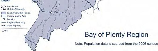
22 12 Bay of Plenty Regional Council consider the social, economic, cultural and environmental factors alongside one another. Ultimately, the Regional Policy Statement focuses on the matters that it can influence to make progress towards a sustainable region Bay of Plenty region overview The Bay of Plenty region ( the region ) is located on the east coast of the North Island of New Zealand (refer to Map 1). The region takes in the full sweep of the coastline of the Bay of Plenty from Potikirua in the east, to the southern end of Homunga Bay, north of Waihī Beach, in the west. On the landward side, the region is mostly bounded by the watersheds of the catchments which flow into the Bay of Plenty, and includes the Rotorua Te Arawa lakes. On the ocean side, it takes in some 18 offshore islands and extends to the limit of the territorial sea. The area of the region is 21,836 km 2, comprising 12,253 km 2 of land 1 and 9,583 km 2 of coastal marine area. The region extends inland generally to the top of the catchments of the surface waters that flow to the Bay of Plenty. The furthest point from the coast, the top of the Rangitaiki River catchment, is some 130 km from the sea. Activities and events on land in these catchments can and do have effects at the coast. Bay of Plenty was the name given by Captain James Cook in 1769 to the north-facing coastline on the east coast of the central North Island. In keeping with its name, the Bay of Plenty provides an impressive array of social, recreational, cultural and economic resources. The region has been continuously settled since the arrival of the great waka some 500 1,100 years ago. Those waka, Mataatua, Tainui, Takitimu and Te Arawa, are still represented in the tribal groupings distributed through the region today. There are 37 iwi authorities within the region, with numerous hapū and marae Understanding the region As conveyed in the name Bay of Plenty, the region is rich in resources available to be used by and for the benefit of people. Volcanic cones, hills and ranges, plateaux, lakes, rivers, forests, geothermal features, the coast and sea, in combination, provide an attraction to residents and visitors alike. The land, water and air have produced forest, pasture, horticulture, mineral resources, and their produce including wood products, animal products, fruit and vegetables and construction materials. The region has a usually resident population of 269,900 people (as at June 2008). The Bay of Plenty is the fifth-most populous region with 6% of New Zealand s population. Population density is highest in the western Bay of Plenty and around the margins of the Rotorua Te Arawa lakes. Approximately 74% of the region s population live in urban areas. The urban population is concentrated in Tauranga and Rotorua. A smaller percentage of the urban population reside in Whakatāne, Kawerau, Te Puke, Katikati and Ōpōtiki. Of the region s population, 28% identify themselves as Māori. This compares with 14% for New Zealand as a whole. The percentage of Māori population increases from west to east across the region, to a high of approximately 70% in some of the smaller eastern Bay of Plenty/East Cape settlements. Compared to New Zealand as a whole, the region has a higher percentage of people in the under-15 and over-60 age groups. The ageing of the region s population will lead to social impacts and changes in the demand for various public services, such as health facilities and public transport. The region s population is projected to increase by 26% by The period to 2021 will see a substantial increase in the region s elderly population and the percentage of population identifying as Māori. Most of the region s population increase is forecast to be in the western Bay of Plenty/Tauranga area. 1 Land includes all islands (inland and offshore, named or unnamed), rivers, lakes and inland waterways, but does not include Tauranga and Ohiwa Harbours and Waihī, Maketū and Whakatāne estuaries.


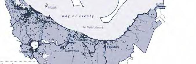
23 Bay of Plenty Regional Council 13 Map 1
24 14 Bay of Plenty Regional Council 1.12 Land use and industry The region is an area of native forest and bush, plantation forestry, pastoral agriculture, and horticulture. The more intensive land uses, e.g. horticulture and dairying, are located mainly on fertile land in the western Bay of Plenty and low-lying coastal plains, while extensive forestry uses dominate the less fertile areas in the south and south-east. Rural production is critical to the Bay of Plenty region, both in terms of food security and foreign exchange earned for the benefit of New Zealand as a whole. Predicted changes to global climate patterns are likely to result in regionally significant changes to temperature, rainfall, evaporation, storm frequency and intensity, and sea level. Plantation forestry is of major importance to the region s economy. The region contains one of the biggest concentrations of plantation forests in New Zealand. The region is home to 13% of New Zealand s exotic plantation forest resources, totalling 215,340 hectares and accounting for 22% of the country s forestry sector workforce. The processing and manufacture of wood products and the manufacture of paper, paper products, printing and publishing are the two primary forms of employment related to wood processing in the region. Dairying is predominately located on fertile, mid-coastal lowlands. The Bay of Plenty region makes up 6% of the nation s dairy industry. The region produces about 80% of national kiwifruit production, centred around the Te Puke and Tauranga Harbour area. In 2011 kiwifruit production accounted for more than 20% of the regional contribution to gross domestic product. Employment in the kiwifruit industry is crucial to the region. In addition to kiwifruit, the potential for expansion of the avocado industry provides an opportunity for significant economic benefit to the region. The region also contains approximately 30% of New Zealand s citrus area. It is one of the dominant regions with regard to nashi, avocados, feijoas, passionfruit and other sub-tropical fruits. While sheep and beef grazing are not as important to the Bay of Plenty region as it is to most other regions, due to the dominance of forestry and dairying, they are a common land use in the highland, steep-sloped areas. Mineral resources of the region (particularly rock, sand and gravel for roading and building) make a significant contribution to the Bay of Plenty economy. The Bay of Plenty is the leading pumice producing region in New Zealand. There is ongoing prospecting and exploration interest in the Bay of Plenty for high value metallic minerals (e.g. gold and silver) and the region has multiple known occurrences of several minerals associated with volcanic activity. The Port of Tauranga is the largest export port in New Zealand and the major international link for the region. The Port of Tauranga is a major component of the region s economy. Strategic road and rail corridors provide the key connections between areas of production and the Port of Tauranga as well as between the ports of Auckland and Hamilton. The major dairy processing factory in the region is situated in Edgecumbe with its milk collection catchment almost matching the region. There is a two-chain meat-processing plant at Rangiuru, east of Te Puke, as well as a number of smaller plants in the region. The Bay of Plenty, and Rotorua in particular, is the third most-important tourism destination in New Zealand. The region receives positive economic benefits from both domestic and international visitors. There are a number of significant electricity generation activities within the region, including hydro-electric power schemes and geothermal power plants. The region is an important producer of electricity from geothermal energy. Its location within the Taupo Volcanic Zone makes the Bay of Plenty one of two main regions with significant geothermal resources.
25 Bay of Plenty Regional Council The region s districts and islands This Statement encompasses seven city or district councils (in whole or in part). Those territorial authority boundaries are shown in Map 2. In addition, the Minister of Local Government is the territorial authority for the region s offshore islands which are administered by the Department of Internal Affairs on the Minister s behalf. The following city and district councils have boundaries within the Bay of Plenty region: Kawerau District Council Ōpōtiki District Council Rotorua District Council Taupō District Council Tauranga City Council Western Bay of Plenty District Council Whakatāne District Council. Parts of the Rotorua District are also contained in the Waikato region, while only a small portion of Taupō District is located within the Bay of Plenty. The region shares its regional boundaries with Waikato and Hawke s Bay regions and Gisborne District. The Bay of Plenty region includes many islands, several of which are inhabited. The main islands are Matakana, Tūhua (Mayor), Mōtītī, Moutohora (Whale) and Whakaari (White).


26 16 Bay of Plenty Regional Council Map 2
27 Bay of Plenty Regional Council 17 Other islands include: Karewa, Rangiwaea, Motuhoa, Moturiki, Motuotau, Motunau, Rurima, Tokata, Moutoki, Ohakana, Uretara Island and the Volkner Rocks (Te Paepae o Aotea). Moturiki and Motuotau Islands are within Tauranga City; Matakana, Rangiwaea and Motuhoa Islands are within the Western Bay of Plenty District; Ohakana Island is within Whakatāne District; and Uretara Island is within Ōpōtiki District. For those islands and islets which are not part of a district, the Minister of Local Government is the territorial authority Application of the Regional Policy Statement across boundaries Natural and physical resources and processes do not stop at city, district or regional boundaries. The Bay of Plenty Regional Council, the region s district and city councils, and neighbouring councils need processes to address issues that cross boundaries. These issues can be resource based, geographic or jurisdictional. The Bay of Plenty Regional Council and the region s district and city councils will promote consistent and integrated application of the objectives, policies and methods contained in this Regional Policy Statement. To this end, they will: Encourage agencies in the region to make provision, where appropriate, for the management of regionally significant issues in a manner consistent with objectives and policies stated in this document. Review city, district and regional plans to give effect to the Regional Policy Statement. Consult neighbouring regional councils over plans prepared under the Resource Management Act. Promote a collaborative approach to managing resource consent applications where the request for a consent involves decisions to be taken by a district or city council, or the Bay of Plenty Regional Council. Promote an integrated approach to managing resource consent applications where the site or effects arising from the proposed activity cross regional, city or district boundaries and have implications for adjoining local authorities. Investigate transferring and delegating powers, functions and duties to other authorities, including iwi authorities, where this will result in more effective or efficient resource management. The Bay of Plenty Regional Council and the region s district and city councils share some functions under the Act. This is for the control of the use of land for the avoidance or mitigation of natural hazards, maintaining and enhancing indigenous biodiversity, and preventing or mitigating any adverse effects of the storage, use, disposal, or transportation of hazardous substances. The policies which describe how these responsibilities have been allocated are IR 7C, IR 8C and NH 7C.
Coastal Environment. Introduction. 4.1 Coastal Environment. Extent of Coastal Environment
 4 The primary objective (set out in Chapter 2) to be implemented by this Chapter is Objective 2.4 ; the following objectives are also relevant due to the objectives integrated nature: 2.1 Tāngata whenua
Local Area Key Issues Paper No. 13: Southern Hinterland townships growth opportunities
 Draft Sunshine Coast Planning Scheme Review of Submissions Local Area Key Issues Paper No. 13: Southern Hinterland townships growth opportunities Key Issue: Growth opportunities for Southern Hinterland
Heritage contributes towards community identity. It teaches us about the past and provides variety and contrast.
 11 HERITAGE 11.1 Background This Chapter presents the Council s objectives, policies, and methods for the protection and management of heritage. These are based upon the identification of significant areas
Bay of Plenty Regional Economic Profile
 CASE STUDY Bay of Plenty Regional Economic Profile COMVITA Comvita is well on track to becoming a company with $100 million dollar annual turnover, from its roots as a pioneer cottage healthcare businesses,
5.2. Historic heritage. Photo: Vaughan Homestead, Long Bay Regional Park, Auckland. (Source: ARC). Historic heritage
. Historic heritage") Photo: Vaughan Homestead, Long Bay Regional Park, Auckland. (Source: ARC). 274 Hazards and heritage Contents 5.2 Introduction 276 monitoring programmes 276 The state of historic heritage 277 Heritage items
Photo: Vaughan Homestead, Long Bay Regional Park, Auckland. (Source: ARC). 274 Hazards and heritage Contents 5.2 Introduction 276 monitoring programmes 276 The state of historic heritage 277 Heritage items
16540/14 EE/cm 1 DG E 1A
 Council of the European Union Brussels, 5 December 2014 (OR. en) 16540/14 ENV 965 CULT 139 NOTE From: To: Subject: General Secretariat of the Council Delegations Charter of Rome on Natural and Cultural
LEVEL 3 GEOGRAPHY COURSE BOOKLET
 LEVEL 3 GEOGRAPHY COURSE BOOKLET Name: Welcome to Level 3 Geography! The Aims of School Geography Geography aims, through its integrative approach, to foster a balanced view of and respect for the environment
PACIFIC ISLANDS REGIONAL OCEAN POLICY. A healthy Ocean that sustains the livelihoods and aspirations of Pacific Island communities.
 PACIFIC ISLANDS REGIONAL OCEAN POLICY VISION A healthy Ocean that sustains the livelihoods and aspirations of Pacific Island communities. THIS IS OUR OCEAN 1. The care of the ocean is the responsibility
Auckland Council District Plan Hauraki Gulf Islands Section Operative 2013 Proposed plan modification no. 1: Plan Change
 Page 1 Auckland Council District Plan Hauraki Gulf Islands Section Operative 2013 Proposed plan modification no. 1: Plan Change Date of public notification: 31 May 2013 Closing date for submission: 1 July
The National Spatial Strategy
 Purpose of this Consultation Paper This paper seeks the views of a wide range of bodies, interests and members of the public on the issues which the National Spatial Strategy should address. These views
TOWARDS STRATEGIC SPATIAL PLANNING IN JAMAICA: THE NATIONAL SPATIAL PLAN
 TOWARDS STRATEGIC SPATIAL PLANNING IN JAMAICA: THE NATIONAL SPATIAL PLAN JIEP 5th Biennial Conference on the Environment: Balancing National Development and Environmental Protection June 6, 2011 Jamaica
Tourism. April State Planning Policy state interest guideline. Department of Infrastructure, Local Government and Planning
 Department of Infrastructure, Local Government and Planning State Planning Policy state interest guideline Tourism April 2016 Great state. Great opportunity. Preface Using this state interest guideline
This table connects the content provided by Education Perfect to the NSW Syllabus.
 Education Perfect Geography provides teachers with a wide range of quality, engaging and innovative content to drive positive student learning outcomes. Designed by teachers and written by our in-house
The Governance of Land Use
 The planning system The Governance of Land Use United Kingdom Levels of government and their responsibilities The United Kingdom is a unitary state with three devolved governments in Northern Ireland,
3l NATURAL HAZARDS AND UNSTABLE GROUND
 Page 1 of Section 3l 3l NATURAL HAZARDS AND UNSTABLE GROUND 3l.1 Introduction A natural hazard is the result of natural processes that form, shape and change the environment and interact or potentially
INTERNATIONAL CULTURAL TOURISM CHARTER Managing Tourism at Places of Heritage Significance (1999)
") INTERNATIONAL CULTURAL TOURISM CHARTER Managing Tourism at Places of Heritage Significance (1999) Adopted by ICOMOS at the 12th General Assembly in Mexico, October 1999. INTRODUCTION The Charter Ethos
INTERNATIONAL CULTURAL TOURISM CHARTER Managing Tourism at Places of Heritage Significance (1999) Adopted by ICOMOS at the 12th General Assembly in Mexico, October 1999. INTRODUCTION The Charter Ethos
CHAPTER 4 HIGH LEVEL SPATIAL DEVELOPMENT FRAMEWORK (SDF) Page 95
 Page 95") CHAPTER 4 HIGH LEVEL SPATIAL DEVELOPMENT FRAMEWORK (SDF) Page 95 CHAPTER 4 HIGH LEVEL SPATIAL DEVELOPMENT FRAMEWORK 4.1 INTRODUCTION This chapter provides a high level overview of George Municipality s
CHAPTER 4 HIGH LEVEL SPATIAL DEVELOPMENT FRAMEWORK (SDF) Page 95 CHAPTER 4 HIGH LEVEL SPATIAL DEVELOPMENT FRAMEWORK 4.1 INTRODUCTION This chapter provides a high level overview of George Municipality s
HELSINKI COMMISSION Baltic Marine Environment Protection Commission
 HELSINKI COMMISSION Baltic Marine Environment Protection Commission HELCOM RECOMMENDATION 24/10 Adopted 25 June 2003, having regard to Article 20, Paragraph 1 b) of the 1992 Helsinki Convention IMPLEMENTATION
Haida Gwaii Queen Charlotte Islands
 Haida Gwaii Queen Charlotte Islands H E R I T A G E T O U R I S M STRATE GY January 2003 Haida Gwaii/Queen Charlotte Islands Heritage Tourism Strategy Working Group The Haida Gwaii/Queen Charlotte Islands
Bay of Plenty Regional Policy Statement. Update Record
 Bay of Plenty Regional Policy Statement Update Record Date Change / Update Provisions Affected Signature 5 July 2016 Change 2 (Natural Hazards) made operative Minor corrections 3 June 2015 Change 1 (Coastal
Natural Resource Management Strategy. Southern Tasmania. Summary. Natural Resource Management Strategy for Southern Tasmania Summary
 Natural Resource Management Strategy Summary Southern Tasmania 2015 2020 Natural Resource Management Strategy for Southern Tasmania 2015 2020 - Summary i Disclaimer In developing this Strategy, every effort
Bay of Plenty Regional Policy Statement Update Record
 Bay of Plenty Regional Policy Statement Update Record Date Change / Update Provisions Affected Signature 14 December 2018 Amendment to insert minimum targets for sufficient, feasible housing development
The Governance of Land Use
 The Governance of Land Use Country fact sheet Czech Republic The planning system Levels of government and their responsibilities The Czech Republic is a unitary state with 3 levels of government: the national
7.34 Spartina (Spartina anglica)
") 7.34 Spartina (Spartina anglica) Why is it a threat? Spartina is a sward forming grass that originates from the United Kingdom. It grows from underground rhizomes. The rhizomes break off and establish
7.34 Spartina (Spartina anglica) Why is it a threat? Spartina is a sward forming grass that originates from the United Kingdom. It grows from underground rhizomes. The rhizomes break off and establish
Geologic Management. Contents
 Geologic Management Contents Introduction... GM-3 Definitions... GM-3 Legislation and Other Guidance... GM-3 Policy Management for Representation... GM-5... GM-5 Inventory of Significant Geologic Features
CLAREMONT MASTER PLAN 2017: LAND USE COMMUNITY INPUT
 Planning and Development Department 14 North Street Claremont, New Hampshire 03743 Ph: (603) 542-7008 Fax: (603) 542-7033 Email: cityplanner@claremontnh.com www.claremontnh.com CLAREMONT MASTER PLAN 2017:
Cross Boundary Issues
 6 Cross Boundary Issues 6 C R O S S B O U N D A R Y I S S U E S 6.1 Introduction The effects of an activity within the coastal marine area are often felt in adjacent areas, outside of the immediate vicinity
24.0 Mineral Extraction
 Chapter 24 - Mineral Extraction 24.0 Mineral Extraction 24.1 Introduction Apart from gravel, sand, rock, limestone and salt extraction in relatively small quantities mineral extraction is not a strong
New Zealand s Next Top Model: integrating tsunami modelling into land use planning
 New Zealand s Next Top Model: integrating tsunami modelling into land use planning Wendy Saunders (MZNZPI), Gegar Prasetya, Graham Leonard GNS Science, Lower Hutt, w.saunders@gns.cri.nz In April 2011 a
The Governance of Land Use
 The planning system Levels of government and their responsibilities The Governance of Land Use Country fact sheet Germany Germany is a federal country with four levels of government. Below the national
1 Introduction. 1 Introduction
 1 Introduction 1 Introduction 1 Introduction Ka ora te wai Ka ora te whenua Ka ora te whenua Ka ora te tangata If the water is healthy The land will be nourished If the land is nourished The people will
Tsunami Inundation Modelling for Bay of Plenty - Executive Summary March 2013
 Tsunami Inundation Modelling for Bay of Plenty - Executive Summary March 2013 1 Inundation Modelling for the Bay of Plenty Executive Summary Tsunami Inundation Modelling for Bay of Plenty - Executive
The Governance of Land Use
 The planning system Levels of government and their responsibilities The Governance of Land Use COUNTRY FACT SHEET NORWAY Norway is a unitary state with three levels of government; the national level, 19
THE SEVILLE STRATEGY ON BIOSPHERE RESERVES
 THE SEVILLE STRATEGY ON BIOSPHERE RESERVES 1 VISION FOR BIOSPHERE RESERVES IN THE 21 ST CENTURY The international Seville Conference on Biosphere Reserves, organised by UNESCO, adopted a two-pronged approach,
Chapter 32. Australia & New Zealand
 Chapter 32 Australia & New Zealand Lesson 1: Physical Geography of Australia & New Zealand Landforms Australia lies between the Pacific and Indian Oceans in the Southern Hemisphere. Although an island,
Towards an International Data Set for MST
 Towards an International Data Set for MST Carl Obst, UNWTO Consultant 15 October, 2018 Background and context The key role of the Measuring the Sustainability of Tourism (MST) project is to support more
Chapter 32. Australia & New Zealand
 Chapter 32 Australia & New Zealand Lesson 1: Physical Geography of Australia & New Zealand Landforms Australia lies between the Pacific and Indian Oceans in the Southern Hemisphere. Although an island,
Application for Geotourism Charter
 Application for Geotourism Charter Thank you for the interest in geotourism as a long-term strategy to foster wisely managed tourism and enlightened destination stewardship. National Geographic s Center
National Perspectives - Portugal. Margarida Almodovar
 National Perspectives - Portugal Margarida Almodovar margarida.almodovar@mam.gov.pt from base line to the external limit of the continental shelf behind 200 miles and according to UNCLOS definitions Economic
CORPORATION OF THE CITY OF COURTENAY COUNCIL MEETING AGENDA
 CORPORATION OF THE CITY OF COURTENAY COUNCIL MEETING AGENDA DATE: Monday, January 14, 2013 PLACE: City Hall Council Chambers TIME: 4:00 p.m. 1.00 ADOPTION OF MINUTES 1. Adopt January 7, 2013 Regular Council
Policy framework The Netherlands and the Polar Regions, Summary and priorities
 Policy framework The Netherlands and the Polar Regions, 2011-2015 Summary and priorities The policy outlined in this Policy Framework for the Polar Regions (2011-2015) is part of the government s orientation
National Land Use Policy and National Integrated Planning Framework for Land Resource Development
 Title National Land Use Policy and National Integrated Planning Framework for Land Resource Development Duration: 32 Weeks Objective: Adoption of appropriate land use planning approaches to: Maintain the
Population Trends Along the Coastal United States:
 Coastal Trends Report Series Population Trends Along the Coastal United States: 1980-2008 U.S. Department of Commerce National Oceanic and Atmospheric Administration National Ocean Service Assessing the
15 March 2010 Re: Draft Native Vegetation of the Sydney Metropolitan Catchment Management Authority Area GIS layers and explanatory reports
 SYDNEY COASTAL COUNCILS GROUP Inc. C/- City of Sydney Council Level 14, 456 Kent Street GPO Box 1591, SYDNEY NSW 2001 Phone: (02) 9246 7791 Facsimile: (02) 9265 9660 Email: info@sydneycoastalcouncils.com.au
Legal problems of environmental management. Spatial planning and space management. M. Gajewski 2014 / 2015
 Legal problems of environmental management Spatial planning and space management M. Gajewski 2014 / 2015 Course contents (in brief) Constitutional basis of the environment protection system. General principles
D14. Volcanic Viewshafts and Height Sensitive Areas Overlay
 D14. Volcanic Viewshafts and Height Sensitive Areas Overlay D14.1. Overlay description The purpose of the Volcanic Viewshafts and Height Sensitive Areas Overlay is to appropriately protect significant
What is Spatial Planning?
 Spatial Planning in the context of the Responsible Governance of Tenure What is Spatial Planning? Text-only version This course is funded by the European Union through the EU-FAO Improved Global Governance
Neighbourhood Planning in Haringey. Myddleton Road Strategic Group 7 th November 2013
 Neighbourhood Planning in Haringey Myddleton Road Strategic Group 7 th November 2013 What is Neighbourhood Planning? Neighbourhood Planning, introduced through the Localism Act 2011, offers an opportunity
Measuring Disaster Risk for Urban areas in Asia-Pacific
 Measuring Disaster Risk for Urban areas in Asia-Pacific Acknowledgement: Trevor Clifford, Intl Consultant 1 SDG 11 Make cities and human settlements inclusive, safe, resilient and sustainable 11.1: By
NORTH VANCOUVER ISLAND MARINE PLAN: OVERVIEW 2015
 NORTH VANCOUVER ISLAND MARINE PLAN: OVERVIEW 2015 North Vancouver Island Marine Plan Overview Refers to: Marine Planning Partnership Initiative. 2015. North Vancouver Island Marine Plan. Copyright 2015
Date: June 19, 2013 Meeting Date: July 5, Consideration of the City of Vancouver s Regional Context Statement
 Section E 1.5 To: From: Regional Planning and Agriculture Committee Lee-Ann Garnett, Senior Regional Planner Planning, Policy and Environment Department Date: June 19, 2013 Meeting Date: July 5, 2013 Subject:
PROPOSED UNESCO FUNDY BIOSPHERE RESERVE
 OVERVIEW PROPOSED UNESCO FUNDY BIOSPHERE RESERVE NEW BRUNSWICK, CANADA NOMINATION DOCUMENT April 10, 2007 The United Nations Educational, Scientific and Cultural Organization (UNESCO) Man and the Biosphere
CLLD Cooperation OFFER
 Title of the proposed project (English) CLLD Cooperation OFFER PARKS PROTECTION III - Management, Protection and Economic Development in Protected Areas Type of project (select as many as you want) Cooperation
CERTIFIED RESOLUTION. introduction: and dated May 29, 2017, as attached, as appropriate
 15322 Buena Vista Avenue, White Rock BC, Canada V4B 1Y6 www.whiterockcity.ca City of White Rock P: 604.541.22121 F: 604.541.9348 /2tC% City Clerk s Office IT E ROC K June 13,2017 Stephanie Lam, Deputy
Mapping Maine s Working Waterfront: for Our Heritage and Economy
 Mapping Maine s Working Waterfront: for Our Heritage and Economy Abstract Mapping Maine s Working Waterfronts is a collaborative project led by the Island Institute that inventories the state s current
Summary. Recommendations on the Fifth Policy Document on Spatial Planning September 2001
 Summary Recommendations on the Fifth Policy Document on Spatial Planning September 2001 2 Introduction In December 2000 the Dutch Cabinet issued Part 1 of the Fifth National Policy Document on Spatial
Growth Management: Analysis of Comments Received and Responses Comments received as of October 16, 2017
 Growth Management: Analysis of Comments Received and s Comments received as of October 16, Comments informing the Region of Peel s growth management work have been summarized with responses below. These
Declaration Population and culture
 Declaration Population and culture The ministers of the parties to the Alpine Convention regard the socio-economic and socio-cultural aspects mentioned in Article 2, Paragraph 2, Item a., as being central
By Lillian Ntshwarisang Department of Meteorological Services Phone:
 By Lillian Ntshwarisang Department of Meteorological Services Phone: +267 3612200 Email: lntshwarisang@gov.bw/ lntshwarisang@gmail.com Introduction Mandate of DMS Function of the Department Services to
DELIVERING ECOSYSTEM- BASED MARINE SPATIAL PLANNING IN PRACTICE
 DELIVERING ECOSYSTEM- BASED MARINE SPATIAL PLANNING IN PRACTICE A first assessment for the UK and Ireland January 08 GLOBAL WARMING IMAGES / WWF ABOUT WWF WWF is the world s leading independent conservation
Waikato District Plan. Plan Change document
 Waikato District Plan Plan Change 17 Ngaruawahia and Surrounding Villages Stage One Proposed Rezoning Plan Change document Throughout this document text OR maps referred to in the text underlined in red
The UN-GGIM: Europe core data initiative to encourage Geographic information supporting Sustainable Development Goals Dominique Laurent, France
 INSPIRE conference Strasbourg 6 September 2017 The UN-GGIM: Europe core data initiative to encourage Geographic information supporting Sustainable Development Goals Dominique Laurent, France Introduction
Resource Consent Application Form 14A
 Resource Consent Application Form 14A To extract gravel from the bed of a river This application is made under Section 88 of the Resource Management Act 1991 (as amended) Phone: 0800 474 082 Website: www.orc.govt.nz
2. Defining fisheries areas
 What does fisheries area mean in the context of the EFF? Axis 4 of the European Fisheries Fund (EFF) is different from the other three Axes in that it targets fisheries areas (it is titled Sustainable
EcoServ-GIS. EcoServ GIS Stage I. Why EcoServ GIS? 17/12/2012
 EcoServ-GIS Ecosystem Services Mapping: A Wildlife Trust GIS Toolkit to map ecosystem services at a county scale Dr Jonathan Winn Living Landscape Coordinator Durham Wildlife Trust Dr Chloe Bellamy Ecosystem
Integrated Infrastructure Planning & Spatial Mapping
 Integrated Infrastructure Planning & Spatial Mapping Presenter: Heidi Dixon, Principal Social Planner, DTPLI 23 May 2014 PART 1 PLAN MELBOURNE : Metropolitan Planning Strategy PART 2 Case Study: DTPLI
State initiative following up the 2006 national planning report
 18 ness districts and public institutions, should be integrated with the opportunities for public transport services. State initiative following up the 2006 national planning report The Ministry of the
Natural Resource Management. Northern Tasmania. Strategy. Appendix 2
 Natural Resource Management Strategy Northern Tasmania 2015 2020 Appendix 2 Appendix 2 Appendix 2. Carbon Planting Spatial Prioritisation In support of this Strategy s development and implementation, work
MARS AREA SCHOOL DISTRICT CURRICULUM GRADE: Grade 4
 MARS AREA SCHOOL DISTRICT CURRICULUM GRADE: Grade 4 Course Title: Social Studies Brief Description Overview: Students will explore the history, geography, government, and economy of the United States with
Derogation Criteria for the Requirements for Generators Network Code
 Derogation Criteria for the Requirements for Generators Network Code Decision Paper Reference: CER/17/084 Date Published: 13/04/2017 Closing Date: 0 Executive Summary Commission Regulation (EU) 2016/631
Land Use in the context of sustainable, smart and inclusive growth
 Land Use in the context of sustainable, smart and inclusive growth François Salgé Ministry of sustainable development France facilitator EUROGI vice president AFIGéO board member 1 Introduction e-content+
Topic 4: Changing cities
 Topic 4: Changing cities Overview of urban patterns and processes 4.1 Urbanisation is a global process a. Contrasting trends in urbanisation over the last 50 years in different parts of the world (developed,
Overview of Methods. Terrestrial areas that are most important for conservation Conservation
 Overview of Methods The goal of the Western Lake Erie Coastal Conservation Vision project (WLECCV) is to define where we should be working locally to optimally achieve regional conservation impact. The
 BPC Policy No , IIM7fyilK Office of the District Clerk TRANSITION ZONE POLICY")
Outline National legislative & policy context Regional history with ESSIM ESSIM Evaluation Phase Government Integration via RCCOM Regional ICOM Framew
 What MSP Implementation could change in the Maritimes Region Tim Hall, Regional Manager Oceans and Coastal Management Division Ecosystem Management Branch Fisheries and Oceans Canada Maritimes Region BIO
A Method for Mapping Settlement Area Boundaries in the Greater Golden Horseshoe
 A Method for Mapping Settlement Area Boundaries in the Greater Golden Horseshoe Purpose This paper describes a method for mapping and measuring the lands designated for growth and urban expansion in the
Dark Sky Initiative Draft Terms of Reference
 Dark Sky Initiative Draft Terms of Reference July 2008 Table of Contents 1.0 Introduction 2 2.0 Initiative intent 2-3 3.0 Initiative goals 3 4.0 Legislation 3 5.0 Municipal Development Plan 3 6.0 Land
Sustainable tourism in for Sustaibale Danang
 Sustainable tourism in for Sustaibale Danang A case study of Balearic Ecotax in Spain toward Sustainable tourism Miki Yoshizumi Associate Professor College of Gastronomy Management Ritsumeikan University
Regional stakeholders strategy of Donegal County Council
 Regional stakeholders strategy of Donegal County Council Table of contents The template comprised five steps in the creation of this communication strategy: 1 Starting point. Communication objectives...
1/20/2013. Introduction to Environmental Geology, 5e. Case History: Island of Hispaniola. Earth History. Earth s Place in Space
 Introduction to Environmental Geology, 5e Edward A. Keller Chapter 1 Philosophy and Fundamental Concepts Intro to Geology: summary haiku Here's geology. It's the study of the Earth - complete entity. Lecture
Natura 2000 and spatial planning. Executive summary
 Natura 2000 and spatial planning Executive summary DISCLAIMER The information and views set out in this study are those of the author(s) and do not necessarily reflect the official opinion of the Commission.
An Environmental Profile of the Island of Jost Van Dyke, British Virgin Islands
 An Environmental Profile of the Island of Jost Van Dyke, British Virgin Islands Executive Summary including Little Jost Van Dyke, Sandy Cay, Green Cay and Sandy Spit This publication was made possible
Economic Activity Economic A ctivity
 5 Economic Economic Activity Activity ECONOMIC ACTIVITY 5.1 EMPLOYMENT... 5-7 5.1.1 OBJECTIVE... 5-7 5.1.2 POLICIES... 5-7 5.2 PROTECTING THE AREA OF EMPLOYMENT... 5-9 5.2.1 OBJECTIVE... 5-9 5.2.2 POLICIES...
Jordan's Strategic Research Agenda in cultural heritage
 Jordan's Strategic Research Agenda in cultural heritage Analysis of main results Alessandra Gandini Amman, Jordan 3 rd November 2013 Main objectives The work performed had the main objective of giving
NATURE AND EXTENT OF PROPOSED DEVELOPMENT. Amount of Development Development Zones Distribution of Density Policies
 NATURE AND EXTENT OF PROPOSED DEVELOPMENT Amount of Development Development Zones Distribution of Density Policies DRAFT POOLBEG PLANNING SCHEME Amount of Development 78 4.1 The rationale for the overall
The inland water related tourism in South Africa by 2030 in the light of global change
 The inland water related tourism in South Africa by 2030 in the light of global change KSA 2 Water-Linked Ecosystems T4: Green economy and sustainable (green) innovations K5/2620 How can natural capital
TREASURE COAST REGIONAL PLANNING COUNCIL M E M O R A N D U M. To: Council Members AGENDA ITEM 4B10
 TREASURE COAST REGIONAL PLANNING COUNCIL M E M O R A N D U M To: Council Members AGENDA ITEM 4B10 From: Date: Subject: Staff December 14, 2018 Council Meeting Local Government Comprehensive Plan Review
Application #: TEXT
 TOWN OF FORT MYERS BEACH 2008 PROPOSED COMPREHENSIVE PLAN AMENDMENTS Application #: 2008-13-TEXT Description: Modify the Coastal Management and Future Land Use Elements to reflect the state s new definition
Proposed Scope of Work Village of Farmingdale Downtown Farmingdale BOA Step 2 BOA Nomination Study / Draft Generic Environmental Impact Statement
 Proposed Scope of Work Village of Farmingdale Downtown Farmingdale BOA Step 2 BOA Nomination Study / Draft Generic Environmental Impact Statement The scope of work that follows incorporates and covers
TOWARDS CLIMATE-RESILIENT COASTAL MANAGEMENT: OPPORTUNITIES FOR IMPROVED ICZM IN BELIZE
 TOWARDS CLIMATE-RESILIENT COASTAL MANAGEMENT: OPPORTUNITIES FOR IMPROVED ICZM IN BELIZE CHANTALLE SAMUELS Coastal Zone Management Authority and Institute The Caribbean Community Climate Change Centre VULNERABILITY
LOUISIANA STUDENT STANDARDS FOR SOCIAL STUDIES THAT CORRELATE WITH A FIELD TRIP TO DESTREHAN PLANTATION KINDERGARTEN
 LOUISIANA STUDENT STANDARDS FOR SOCIAL STUDIES THAT CORRELATE WITH A FIELD TRIP TO DESTREHAN PLANTATION KINDERGARTEN Standard 2 Historical Thinking Skills Students distinguish between events, people, and
KUNMING FORUM ON UNITED NATIONS GLOBAL GEOSPATIAL INFORMATION MANAGEMENT CITIES OF THE FUTURE: SMART, RESILIENT
 KUNMING FORUM ON UNITED NATIONS GLOBAL GEOSPATIAL INFORMATION MANAGEMENT CITIES OF THE FUTURE: SMART, RESILIENT and SUSTAINABLE Yunnan Zhenzhuang Guest House, Kunming, China 10 12 May 2017 BACKGROUND CONCEPT
Marine Spatial Planning: A Tool for Implementing Ecosystem-Based Management
 Marine Spatial Planning: A Tool for Implementing Ecosystem-Based Management Steven Murawski, Ph.D., Ecosystem Goal Team Lead National Oceanic and Atmospheric Administration NOAA November 16, 2009 1 To
D14. Volcanic Viewshafts and Height Sensitive Areas Overlay
 D14. Volcanic Viewshafts and Height Sensitive Areas Overlay D14.1. Overlay description The purpose of the Volcanic Viewshafts and Height Sensitive Areas Overlay is to appropriately protect significant
Making maps: Traditions and perceptions in Europe. European spatial planning and cartographic representations
 ESPON Create Europe! Making maps: Traditions and perceptions in Europe Dr. Stefanie Dühr University of the West of England, Bristol, UK European spatial planning and cartographic representations Scenarios.
Urbanization and Sustainable Development of Cities: A Ready Engine to Promote Economic Growth and Cooperation
 Urbanization and Sustainable Development of Cities: A Ready Engine to Promote Economic Growth and Cooperation Wan Portia Hamzah Institute of Strategic and International Studies (ISIS) Malaysia 10 September
Key Indicators for Territorial Cohesion & Spatial Planning Stakeholder Workshop - Project Update. 13 th December 2012 San Sebastián, Basque Country
 Key Indicators for Territorial Cohesion & Spatial Planning Stakeholder Workshop - Project Update 13 th December 2012 San Sebastián, Basque Country Key Aims Explore the use of territorial data in developing
T he O utlet: Almirante
 T he O utlet: Almirante For me, the sea is life. This understanding also holds true with our rivers. Each are alive, and carry life with them as they reach the sea. Our rivers, are born up high in the
Law on Spatial Planning
 UNITED NATIONS United Nations Interim Administration Mission in Kosovo UNMIK NATIONS UNIES Mission d Administration Intérimaire des Nations Unies au Kosovo PROVISIONAL INSTITUTIONS OF SELF GOVERNMENT Law
Why Do We Live Here? : A Historical Geographical Study of La Tabatiere, Quebec North Shore
 Why Do We Live Here? : A Historical Geographical Study of La Tabatiere, Quebec North Shore Lesson Overview Many communities and their occupants have historical connections to exploration routes and traditional