One of its major program is to design a value based curriculum for school to nurture and culture our future generations with excellence.
|
|
|
- Elinor Webb
- 5 years ago
- Views:
Transcription
1
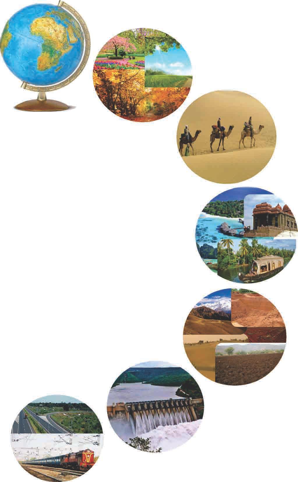
2 Introduction Millat Foundation for Educational Research and Development (MFERD) is an organization conceived with the vision of providing a common platform for the networking, coordination, collaboration and co-operation among Muslim educational institutions, thereby complementing the efforts of individuals and organizations in achieving excellence in education within the boundaries of Islamic Shariah. MFERD aims to address the various challenges faced by these institutions and find solutions through research and development. One of its major program is to design a value based curriculum for school to nurture and culture our future generations with excellence. Curriculum is the sum total of all learning experience a child undergoes including academics, activities, learning environment, assessment and interaction with teachers, students, parents all together from the moment a child walks in the school until he/she steps out. After years of research in child psychology, education from Islamic perspective, and review of various curricula, a value based curriculum has been designed in accordance with National Curriculum Framework and International standards to focus on all round development of the children so that they identify their identity, realize the need and become leaders of tomorrow. This curriculum is comprised of: Objectives - as per Islam psychology, education and stakeholders Syllabus - as per age group and government standards Methodology - child centric and appropriate to the subject and objectives Resources - including teacher training, teaching aids manuals and more Assessment - formative, summative, self, co-scholastic, behavioral and long term Activities - curricular, co-curricular and extra curricular with guidelines for events Scheduling - calendar, day-year plans, workload, period split and competitions Observation - feedback and research Central Academic Development department has been setup to plan, train and monitor the implementation of this curriculum in various schools at all the levels. I
3 Preface Social studies is the study of people in relation to each other and to the world in which they live. It comprises the disciplines of history, geography, civics and economics. As a study of human beings in their physical, social and cultural environment, social studies examines the past and present and looks towards the future. It helps students acquire the skills, attitude, knowledge and values that will enable them to become engaged, active, informed and responsible citizens and contributing members of their communities, locally, nationally and globally. It encourages to develop their sense of self and community, enthusing them to affirm their place as citizens in an inclusive and democratic society. Life and stories of the Prophets of Allah as mentioned in the Quran and Hadees are the best medium to introduce Islamic history to young Muslims. We believe in developing a historical perspective where historical materials are not merely used as a chain of events, dates and names, rather they become basic fountain of learning through which students are able to relate their own life experiences in the perspective of social studies. Students should be acquainted with the relationship between obedience to Allah's command and Allah's rewards and the consequent punishment of not doing so. Gaining insight into these processes will enable the learners to be receptive to the teaching of the Quran and Sunnah and identifies his identity. Knowledge and comprehension of geographical concepts of locations, time, space, distance and direction have also been accorded in lucid manner. It is to ingrain in the minds of young that Allah has created the heaven and the earth and he has made land and water bodies with the specific light thrown on our country India and its states with a great variety of foods eaten and the clothes worn therein. We hope that the book would prove to be a rich source for learners to enrich their knowledge of the world in Islamic perspective and social studies. II
4 III
5 Contents Geography I. Explore Our World 1. Globes and Maps 1 2. Indian Weather and Climate 9 II. Explore Our Country 3. The Northern Mountains and the Northern Plains The Great Indian Desert and the Southern Plateau The Coastal Plains and the Islands 30 III. Explore Our Resources 6. Indian Soil and Water Resources Forest and Wild Life of India Agriculture and Industries of India Our Mineral Resources Transport and Communication 65


6 Unit - 1 Explore Our World 1 Globes and Maps Indian Weather and Climate 2


7 Globes and Maps 1 Earth is our home planet. Many years ago people believed that the Earth was flat. Abu Rehan Muhammad Bin Ahmed Al-Beruni researched and found in th the 11 century C.E. that the Earth is round like a ball by calculating its circumference. th Later in the 15 century C.E., a Portuguese explorer Ferdinand Magellan sailed only towards the West and returned to the same place after three years, thus proving that the Earth is round. With the photos of the earth taken from the space, it is proved beyond doubt that the earth is round. Globe We cannot study Earth at one time as it is very big. Study becomes easy with the help of a spherical model of the earth called globe. A globe helps us to identify the shape, location of different continents, countries, oceans and seas. The globe spins on a rod. This rod represents the Earth's axis. The Earth's axis is an imaginary line passing through the centre of the Earth. The top-most part of the rod represents the north Globe pole and the lower most part of the rod represents the south pole. The equator is an imaginary line passing through the centre of the Earth dividing the Earth into two equal halves called hemispheres. The upper part is the Northern Hemisphere and the lower part is the Southern Hemisphere. Tap your knowledge 1 Let us learn: Globe and its use Latitudes and Longitudes, Maps Types of maps Language of a map Direction, scale, Legend or key Colours and symbols 1. The Earth's axis is an line passing through the centre of the Earth. 2. The shape of the Earth is. The Earth


8 Latitudes Latitudes are imaginary lines that run from East to West. These lines are parallel to each other. The distance between latitudes is equal. They are also called the parallels of latitude. These lines keep on decreasing and at the poles 0 0 they are 90 N or 90 S of the equator. The other important 0 lines are Tropic of Cancer at 23 ½ N, Tropic of Capricorn at Latitudes ½ S and the Antarctic Circle at 66 ½ S and Arctic Circle at 66 ½ N. Longitudes Longitudes are imaginary lines that run from the north pole to the south pole. These lines are not parallel to each other. These lines are also called the Meridians of 0 longitude. These imaginary lines are numbered from to 180. Meridian o runs through Greenwich near London. The longitudes to the East of Greenwich are East longitudes and to the West of Greenwich are West Longitudes longitudes. As longitudes and latitudes run from north to south and east to west, they form a network called grid. Grid helps us to accurately locate places on maps and globes. Tap your knowledge runs through Greenwich near London. 2. Meridian is the other name of. Maps The word map comes from a Latin word 'mappa' which means a napkin. Like a napkin, a map can also be folded easily. Maps show shapes of land and sea, the position of places on them and give us detailed information. The first cartographer and geographer was Al-Idreesi who made the accurate map of the world. Muhammed Al-Idreesi was a geographer (expert of geography), cartographer (a map maker) and a traveller. He was born in 1099 in Ceuta, Spain and died in 1168 in Sicily. Al-Idreesi was a descendant of Hasan Bin Ali ( ), the son of Ali ( ) and the grandson of Prophet Muhammed ( r). 2


9 There are three types of maps. They are physical, political and thematic. Physical map : A m a p w h i c h shows the different land forms such as mountains, seas, rivers, lakes, forests, plains and plateaus. Physical map Political map : A map which shows countries, states, their capitals and major cities. Political map Thematic map : A map which shows how much rainfall a place gets. Some thematic maps also show whether the place is a desert, forest, hill or a plain. How do you use this book? 3 Thematic map
10 Maps which show small areas such as streets, house or a room are called plans. When different types of maps are put together in the form of a book, it is called an atlas. Tap your knowledge 1. The word map comes from a Latin word which means napkin. ( ) Language of a map We can understand a map better if we use direction, scale, colours and symbols, legend or a key. These things are called as the language of a map. Directions Directions help us to locate a place on a map easily. This is the most important part of a map. There are four main directions, North, WEST (LEFT) South, East and West. Generally on a map the top shows the North, the bottom shows SOUTH (BOTTOM) the South, the right side shows the East and the left side shows the West. Once we know Different directions these directions it becomes easier for us to locate places on a map. Between the North and the East lies the North-East, between the South and the East lies the South-East. Similarly between the South and West lies the South-West and between the North and the West lies the North-West. Scale a. mappa b. mippo 2. There are types of maps. ( ) a. two b. three The distance between two places on a map is shown with the help of a scale. A scale is the ratio between the distance of two places on the map with the actual distance of the two places on land. 4 NORTH (TOP) EAST (RIGHT)
11 FactFile About 4000 years ago the first map was made on clay tablets in Egypt. Suppose the distance between Hyderabad and Zaheerabad is 100 kilometres. As per the scale on the map, 1 cm represents 100 km. Hence the actual distance of 200 kms on land will be shown as 2 cm on the map. Maps are usually drawn to scale. The scale is usually mentioned in the corner of the map. Colours and symbols Colours and symbols help us to show the different features such as oceans, seas, mountains, plains, deserts, cities, roads, railways, etc. All the maps follow a common colour scheme. Colour scheme followed in maps Ø Blue represents water bodies Ø Brown represents mountains Ø Yellow represents plateaus Ø White represents snow covered areas Ø Green represents plains and low lands Symbols on the map show cities, capitals, ports, railways, bridges, roads, airports, hospitals, post offices, rivers, boundaries and many such things. Legend or key Scale km 200 km 300 km 400 km The legend or key on a map shows what the colours and symbols used on it mean. Usually colours and symbols are given at the corner of a map. 1 cm A scale where 1 cm on the map is equal to 100 km on the actual surface. Legend on a map River Tank Airport House Bridge Road Forest Post office Temple Lake Railway line Hospital Masjid Church 5
12 Keywords explorer equator Summary a person who travels in order to discover and learn about new places an imaginary line passing through the centre of the Earth dividing it into two equal halves latitudes imaginary lines that run from east to west longitudes imaginary lines that run from north pole to the south pole The Earth is spherical in shape. A globe is a model of the Earth. Maps can be easily folded and carried than globes. There are three types of maps physical, political and thematic. 1. Answer the following questions. a. In what ways do globes and maps help us? b. What is an atlas? c. Name the four sub-directions. d. Name the different types of maps. e. What are latitudes and longitudes? 2. Fill in the blanks. A book of various types of maps is called an atlas. The language of a map including, directions, scale, colour and symbols, and legend or key is used to understand a map. a. The explorer, Ferdinand Magellan proved that th the Earth is round in the 15 century. b. On a map water bodies are shown in colour. c. The passes through the centre of the Earth. d. Maps showing small areas in detail such as streets, houses, etc. are called. e. Maps are usually drawn to. 6
13 3. Match the columns. o a. Earth ( ) i. 23 ½ N b. Globe ( ) ii. sub-direction c. Tropic of Cancer ( ) iii. shows different land forms d. North-West ( ) iv. home planet e. Physical map ( ) v. model of the Earth 4. Write T for true sentences and F for false sentences. a. Abu Rehan Muhammad Bin Ahmed Al-Beruni researched in 11th century and proved that the Earth is round. ( ) b. An equator is an imaginary line passing through the centre of the Earth. ( ) c. A political map shows the different land forms. ( ) d. On a map brown colour represents mountains. ( ) 5. What do these keys mean on a map? 7 2

 travelled.")

14 Give it a thought You are given a choice to visit five places of the world. How will you reach there and which place will you choose? Finding Information 1. Find out how many times the word 'Earth' (Arabic word 'Ardh') is mentioned in the Quran. 2. Draw the map of the places where Prophet Muhammed (r) travelled. Reading a map Use the symbols and mark these on the grid as per the instructions. 1. Draw a school in Cliff Town. 2. Draw fishes in Broad Bay. 3. Draw a light house in Hilton Town. 4. Draw a railway track connecting Hilton Town to Cliff Town. th st nd 5. Draw mountains in 20, 21, 22 squares. th 6. Draw a town in 17 square. 7. Place a ship in River Ray. 8. Draw a masjid in Newton. 2 8
GEOGRAPHY POLICY STATEMENT. The study of geography helps our pupils to make sense of the world around them.
 GEOGRAPHY POLICY STATEMENT We believe that the study of geography is concerned with people, place, space and the environment and explores the relationships between the earth and its peoples. The study
About places and/or important events Landmarks Maps How the land is, hills or flat or mountain range Connected to maps World Different countries
 What do you think you know about geography? About places and/or important events Landmarks Maps How the land is, hills or flat or mountain range Connected to maps World Different countries What do you
INTERNATIONAL INDIAN SCHOOL, RIYADH HALF YEARLY
 INTERNATIONAL INDIAN SCHOOL, RIYADH HALF YEARLY 2018-19 STD V Fill in the blanks: WORKSHEET LESSON - 1 KNOW YOUR PLANET SOCIAL STUDIES 1 A book containing maps is called an _ 2 A Flemish map maker, collection
New National Curriculum Geography Skills Planning KS1
 New National Curriculum Geography Skills Planning KS1 Enquiry Question Objective-essential knowledge skills or understanding Locational Knowledge Standards /Success Criteria Lesson progression over half
Year 1 name and locate the four countries and capital cities of the United Kingdom and its surrounding seas
 Long Term Objective Organisation for Geography Please note that only statutory requirements should be included in this document; any supplementary guidance and information should be retained by Subject
name and locate the world s seven continents and five oceans
 Subject: Geography Activities National Curriculum Objectives One Progression of Skills Name the 7 continents and 5 oceans 3D Jigsaw task to locate continents and seas name and locate the world s seven
Map Skills Unit. Note taking unit
 Map Skills Unit Note taking unit Introduction To learn about the Earth, we are going to learn about two geographic tools you can use.globes and maps. Globe A globe is a round model of the planet Earth
Complete Geography Overview: Year 1 to Year 6
 Option 1 Complete Geography Overview: Year 1 to Year 6 Autumn Term Spring Term Summer Term Year 1 Where do I live? Around the World The Four Seasons Year 2 At the Farm Let s go on Safari My World and Me
MEADOWS PRIMARY SCHOOL and NURSERY GEOGRAPHY POLICY
 MEADOWS PRIMARY SCHOOL and NURSERY GEOGRAPHY POLICY Purpose of study The teaching of Geography at Meadows is done by following the 2014 National Curriculum. The planning and teaching of the subject aims
Tuition, Medical and Behaviour Support Service
 Tuition, Medical and Behaviour Support Service Curriculum Policy - Primary Geography Reviewed: October 2018 Next Review: October 2019 Responsibility: Andrea Snow AIMS AND PRINCIPLES The national curriculum
GEOGRAPHY POLICY. Date: March Signed: Review: March 2019
 GEOGRAPHY POLICY Date: March 2018 Signed: Review: March 2019 Aims At Hayton C of E Primary School we believe that Geography is an essential part of the curriculum and teachers ensure that the children
GRADE 6 GEOGRAPHY TERM 1 LATITUDE AND LONGITUDE (degrees)
") 1 GRADE 6 GEOGRAPHY TERM 1 LATITUDE AND LONGITUDE (degrees) Contents Lines of Latitude... 2 Lines of Longitude... 3 The hemispheres of The Earth... 4 Finding countries and cities on a map using latitude
1 GRADE 6 GEOGRAPHY TERM 1 LATITUDE AND LONGITUDE (degrees) Contents Lines of Latitude... 2 Lines of Longitude... 3 The hemispheres of The Earth... 4 Finding countries and cities on a map using latitude
St John s Catholic Primary School. Geography Policy. Mission Statement
 St John s Catholic Primary School Geography Policy Mission Statement We at St John s strive for excellence in education by providing a safe, secure and caring family environment where individuals are valued
St Joseph s R.C. Primary School. Policy for Geography
 St Joseph s R.C. Primary School Policy for Geography 2016-2017 This policy is written with consideration to our school commitment to the Rights of the Child and our achievement of becoming a Rights Respecting
Pikes Lane Primary School. Geography Statement of Practice
 Pikes Lane Primary School Geography Statement of Practice Subject Leader: Mrs Cawley Subject Link Governor: Mr Scholar & Mrs Azad Last Updated: September 2016 Review Date: September 2017 Aims and objectives
Geography Mile Post 1
 Mile Post 1 Use world maps, atlases and globes to identify the UK and its countries, as well as the countries, continents and oceans studied at this key stage Key Skills IPC learning Goals 1.11 Be able
Geography Progression
 Geography Progression This document aims to track expectations for History within George Grenville Academy. What the National Curriculum says: KS1: Locational Knowledge: Name and locate the world s 7 continents
Geography Long Term Plan 2018
 Geography Long Term Plan 2018 Geography Co-ordinator: Megan Frost A high-quality geography education should inspire in pupils a curiosity and fascination about the world and its people that will remain
ST AMBROSE CATHOLIC PRIMARY SCHOOL Geography Policy
 ST AMBROSE CATHOLIC PRIMARY SCHOOL Geography Policy 2017-2018 Our school policy is developed in accordance with the National Curriculum for Geography and Foundation Stage Curriculum for Understanding of
Dr. M.K.K. Arya Model School Class-V, Social Science Assignment Ch-1, Globe The Model of the Earth Answer the following:- Q.1.
 Class-V, Social Science Assignment Ch-1, Globe The Model of the Earth - Q.1. What are the disadvantages/demerits of a globe? Ans. Some disadvantages of globe are: a) It is difficult to carry. b) It cannot
Some of these parallels are very important. In the Northern Hemisphere, there is the Tropic of Cancer and the Arctic Circle.
 PDF 2 Geographic coordinates 1 The geographic coordinates system is network of imaginary horizontal and vertical lines that are drawn on globes or maps. These lines are called parallels (lines of latitude)
Nursery. Reception. Year 1
 Nursery Geography Overview Autumn Spring Summer Notices detailed features of objects in their environment. Comments and asks questions about aspects of their familiar world such as the place where they
Geography Skills Progression. Eden Park Primary School Academy
 Geography Skills Progression Eden Park Primary School Academy In order to ensure broad and balanced coverage, we follow these principles: Within each phase, geography is a driver for at least 3 Learning
Geography Policy 2014
 Geography Policy 2014 DEFINITION Geography education should inspire in pupils a curiosity and fascination about the world and its people that will remain with them for the rest of their lives. Teaching
The Geography Curriculum at Coston Primary
 The Geography Curriculum at Coston Primary Years Year 1 Year 2 Summer We are learning about where food is farmed and in The physical features of farms. The human features of farms. The characteristics
NEWHAM BRIDGE PRIMARY SCHOOL FOUNDATION SUBJECTS CURRICULUM AND ASSESSMENT DOCUMENT GEOGRAPHY
 NEWHAM BRIDGE PRIMARY SCHOOL FOUNDATION SUBJECTS CURRICULUM AND ASSESSMENT DOCUMENT GEOGRAPHY Y1 Geography Curriculum Y1 Geography A.R.E Locational language: hills, beach, forest, town, country, address,
Geography Route Planner
 Geography Route Planner Introduction to Route Planners Route Planners outline the Key Stages 1-3 curriculum to be taught within each campus of the Bury St Edmunds Trust. Each Route Planner has been designed
Geography. Programmes of study for Key Stages 1-3
 Geography Programmes of study for Key Stages 1-3 February 2013 Contents Purpose of study 3 Aims 3 Attainment targets 3 Subject content 4 Key Stage 1 4 Key Stage 2 5 Key Stage 3 6 2 Purpose of study A high-quality
Geography Long Term Plan
 Geography Long Term Plan Year Group Children should be taught about: The topic this will be based on: Essential Learning Objectives: (Taken from Chris Quigley) Year 1 Name and locate the world s seven
Map Skills and Geographic Tools
 Name: Period: Map Skills and Geographic Tools TEKS: 8.9C interpret topographic maps and satellite views to identify land and erosional features and predict how these features may be reshaped by weathering
What Is a Globe? Hemispheres. Main Idea Globes and maps provide different ways of showing features of the earth. Terms to Know
 r Main Idea Globes and maps provide different ways of showing features of the earth. Terms to Know hemisphere latitude longitude scale bar scale relief elevation contour line What Is a Globe? A globe is
Range of Opportunities
 Geograhy Curriculum Cropwell Bishop Primary School Range of Opportunities Year 1 Year 2 Year 3 Year 4 Year 5 Year 6 All Key Stage 1 Key Stage 2 Investigate the countries and capitals of the United Kingdom.
THE EARTH AND ITS REPRESENTATION
 UNIT 7 THE EARTH AND ITS REPRESENTATION TABLE OF CONTENTS 1 THE EARTH AND THE SOLAR SYSTEM... 2 2 THE EARTH S MOVEMENTS... 2 2.1 Rotation.... 2 2.2 The revolution of the Earth: seasons of the year....
NATIONAL CURRICULUM GEOGRAPHY PLANNING OVERVIEW
 GEOGRAPHY AUTUMN TERM SPRING TERM SUMMER TERM Year 1 Hunting and Hiding Me and My Wonderful World Beside The Sea identify seasonal and daily weather patterns in the United Kingdom and the location of hot
Geography Class 6 Chapters 3 and
 CHAPTER 3 MOTIONS OF THE EARTH The Earth is always travelling in Space. That makes each person on Earth, a Space Traveller. No one feels the movement of the Earth because humans are too tiny when compared
Our Lady Immaculate Catholic Primary School History and Geography Curriculum Map Would the Bog Baby survive in Liverpool?
 Year 1 and 2 - *Year 1 and 2 work on a two year cycle due to mixed classes Autumn 1 National Curriculum link: Human and physical geography - identify seasonal and daily weather patterns in the United Kingdom
Geography Policy. Introduction
 Geography Policy Introduction Geography at St. Aloysius Federation School teaches an understanding of places and environments and aims to inspire a curiosity and fascination about the world and its people.
HOLY CROSS CATHOLIC PRIMARY SCHOOL
 HOLY CROSS CATHOLIC PRIMARY SCHOOL Geography Policy Date Implemented Jan 17 Review Date Jan 22 Mission Statement Holy Cross Primary School is a Catholic School. We seek to provide a broad, balanced Christian
Geography Long Term Plan. Autumn Spring Summer
 Geography Long Term Plan Autumn Spring Summer Year 1 Working Scientifically covered throughout the year Location Geography of UK Name, locate and identify characteristics of the four countries and capital
Downloaded from
 SOCIAL STUDIESCLASS - V LESSON-1 GLOBE ANSWER THE FOLLOWING: 1. Name the continents and oceans on the earth. Ans. The seven continents are: a) Australia b) Europe c) Antarctica d) South America e) North
St. James C of E Primary School
 St. James C of E Primary School Geography Policy St. James C of E Primary School Geography Policy Written by: Lisa Harford Written: April 2016 Reviewed: April 2018 1. Introduction Geography is concerned
locate the world s countries, using maps to focus on Europe (including the location of
 Year 3 and 4 Geography study- Autumn 2 2017 National curriculum: Locational knowledge locate the world s countries, using maps to focus on Europe (including the location of Russia) and North and South
Geography Policy. for Hertsmere Jewish Primary School
 Geography Policy for Hertsmere Jewish Primary School Reviewed by: L Rubin Reviewed on: September 2017 Date of Next Review: September 2018 Policy Review This policy will be reviewed in full by the Governing
Holy Trinity 3-16 School. Geography Overview (Primary)
") Holy Trinity 3-16 School Key Stage 1 Geography Overview (Primary) Year Autumn 1 Autumn 2 Spring1 Spring 2 Summer 1 Summer 2 Y1 Dear Zoo Castles Gadgets and Gizmos (UK) Name, locate and identify characteristics
Holy Trinity 3-16 School Key Stage 1 Geography Overview (Primary) Year Autumn 1 Autumn 2 Spring1 Spring 2 Summer 1 Summer 2 Y1 Dear Zoo Castles Gadgets and Gizmos (UK) Name, locate and identify characteristics
STAG LANE JUNIOR SCHOOL GEOGRAPHY POLICY
 Status-Recommended Prepared by: Megha Visavadia Date written January 2017 Shared with staff: Spring 2017 STAG LANE JUNIOR SCHOOL GEOGRAPHY POLICY Shared with governors: Spring 2018 Date for review: July
Subject Progression Map
 Subject Progression Map On website Subject Name: Geography Vision-Taken from the National Curriculum A high-quality geography education should inspire in pupils a curiosity and fascination about the world
Cranford Park CE Primary School. Subject Overview for Geography. Autumn 1 Autumn 2 Spring 1 Spring 2 Summer 1 Summer 2 Title of unit.
 Autumn 1 Autumn 2 Spring 1 Spring 2 Summer 1 Summer 2 Main Objectives /Skills Main Objectives /Skills Main Objectives /Skills Main Objectives /Skills Main Objectives /Skills Main Objectives /Skills Foundation
KS1. Geography Progression of Knowledge, Understanding and Skills WIJPS
 Geography Progression of Knowledge, Understanding and Skills WIJPS Geography inspires pupils to delve deeper and with more curiosity and fascination into the world around them and its people. The knowledge
2 Mapping Earth Reading Essentials. 2. Contrast What is the difference between a map view and a profile view?
 Mapping Earth Maps What do you think? Read the three statements below and decide whether you agree or disagree with them. Place an A in the Before column if you agree with the statement or a D if you disagree.
Gedney Church End and Lutton St Nicholas Federated Primary Schools. Geography Policy
 Gedney Church End and Lutton St Nicholas Federated Primary Schools Geography Policy Contents: Introduction Expectations in Key Stage 1 Expectations in Key Stage 2 Aims Teaching and Learning Key Skills
GEOGRAPHY CURRICULUM OVERVIEW
 GEOGRAPHY CURRICULUM OVERVIEW Geographical knowledge Progression Statement Autumn Spring Summer Year 1 UK and Local Area: Physical Themes: Name, locate and identify characteristics of the 4 countries and
Pool Canvas. Add. Creation Settings. Chapter 1--Objectives and Tools of World Regional Geography. Description Instructions.
 1 of 6 TEST BANK > CONTROL PANEL > POOL MANAGER > POOL CANVAS Pool Canvas Add, modify, and remove questions. Select a question type from the Add Question drop-down list and click Go to add questions. Use
Map Skills Test. 1. What do we call a person who makes maps? a. mapographer b. cartographer c. geologist d. archaeologist
 Map Skills Test 1. What do we call a person who makes maps? a. mapographer b. cartographer c. geologist d. archaeologist 2. What is the name of the 0 latitude line? a. Equator b. Arctic Circle c. First
Globes, Maps, and Atlases. Plus, A Whole Bunch of Other Way Cool Geographic Information!!!
 Globes, Maps, and Atlases Plus, A Whole Bunch of Other Way Cool Geographic Information!!! Globes Are the Most Accurate Portrayal of the Earth The earth is about 24,900 miles in circumference, and about
Understanding Projections
 GEOGRAPHY SKILLS 1 Understanding Projections The earth is a sphere and is best shown as a globe. For books and posters, though, the earth has to be represented as a flat object. To do this, mapmakers create
HOLIDAY HOMEWORK CLASS 5
 HOLIDAY HOMEWORK CLASS 5 SCIENCE Take three earthen pots and put some soil in each of them. Take a small onion, a small potato with an eye and a piece of rose stem. Cover the onion and the potato with
Geography Skills Progression Key Stage 2
 Year 3 Year 4 Year 5 Year 6 Expectations at end of key stage Location knowledge the countries of Europe? countries in Europe, environmental regions? countries in Europe, key physical and human characteristics?
Map Skills Lesson 1. Materials: maps, pencils, Lesson 1 Worksheet, strips of paper, grid paper
 Map Skills Lesson 1 Use cardinal directions, map grids, scales, and titles to locate places on a map. Interpret a map using information from its title, compass rose, scale, and legend. Vocabulary: map,
Introduction to Geography
 Introduction to Geography ropic of Cancer 3½ N Arctic Circle 90 N Prime Meridian 0 Arctic Ocean Mississippi R. Appalachian Mts. Europe Rocky Mountains N. America Atlantic Gulf of Ocean Mexico Caribbean
MR. GOFF S WORLD HISTORY UNIT ONE: GEOGRAPHY 5 THEMES OF GEOGRAPHY
 MR. GOFF S WORLD HISTORY UNIT ONE: GEOGRAPHY 5 THEMES OF GEOGRAPHY BYOD BRING YOUR OWN DEVICE IN SMALL GROUPS (3-4), USE YOUR ELECTRONIC DEVICE(S) AND DEFINE THE FOLLOWING VOCAB. WORDS 1. GEOGRAPHY 2.
Witchampton CofE First School Geography Curriculum Map
 2016-2017 Autumn People and : 30-50 Show interest in the lives of people who are familiar to them. Shows interest in different occupations. Remembers and talks significant events in their own experience.
DR. M. K. K. Arya Model School Ch- 3 Motions of the Earth (Geography) Class-VI Assignment
 Class-VI Assignment") DR. M. K. K. Arya Model School Ch- 3 Motions of the Earth (Geography) Class-VI Assignment 1 What are axis and orbit? A Axis- The axis of the Earth is an imaginary line joining the North pole with the South
DR. M. K. K. Arya Model School Ch- 3 Motions of the Earth (Geography) Class-VI Assignment 1 What are axis and orbit? A Axis- The axis of the Earth is an imaginary line joining the North pole with the South
Display/Resources ideas:
 Year 3/4 Key Skills to be covered, taken from National Curriculum pitching at the correct year group and differentiation within plan for different groups Be specific in the key skills, and make them more
Grade Level, Course Third Grade Social Studies PLSD Balanced Assessment Practices. Type* DOK
 Unit Guides Assessment Items Indic ator s Concept Standard Curricular Indicator DOK Type* SR CR PB Assessment Questions # DOK Level 1E 1M 1H 2E 2M 2H 3E 3M 3H Civics Students will develop and apply the
Sample. Contents SECTION 1: PLACE NAMES 6 SECTION 2: CONNECTING TO PLACES 21 SECTION 3: SPACES: NEAR AND FAR 53
 Contents Teachers' Notes 4 National Curriculum Links 5 SECTION 1: PLACE NAMES 6 Teachers' Notes 7-8 Activities Names Of Places 9 Place Names Are Important 1 10 Place Names Are Important 2 11 The Meanings
1. Match the words in the first column to the meaning in the second column. [5]
![1. Match the words in the first column to the meaning in the second column. [5]](/thumbs/96/126839765.jpg "1. Match the words in the first column to the meaning in the second column. [5]") Exercise 1: [40 POINTS] 1. Match the words in the first column to the meaning in the second column. [5] Equator Around earth between the Equator and the Poles. Greenwich meridian Half of earth. Longitude
Exercise 1: [40 POINTS] 1. Match the words in the first column to the meaning in the second column. [5] Equator Around earth between the Equator and the Poles. Greenwich meridian Half of earth. Longitude
Unit 1: Basics of Geography Test Review
 Name Date Period Unit 1: Basics of Geography Test Review Directions: Reading the following sections and complete the questions, charts, and diagrams. Types of Maps Maps that have a particular theme are
4th Grade US Regional Geography First Nine Weeks
 4th Grade US Regional Geography First Nine Weeks 2014-2015 Identify the choice that best completes the statement or answers the question. 1 The line identified as 0 runs west and east on the globe and
Simple Solutions Social Studies Level 2. Level 2. Social Studies. Help Pages
 Level 2 Social Studies 147 148 adobe houses with bricks made of clay and straw ancestor a family member who lived before us appoint choose; leaders can appoint others barter trading one thing for another
Cardinal and Intermediate Directions:
 Name Period Parent Signature Due Date: (TBA) Geography/Map Skills Study Guide Continents and Oceans of the World: Label the continents (7) and oceans (4) on the lines below the map. 1 11 3 5 4 8 2 9 10
5 Themes of Geography Review Video Notes What is Geography?
 Name PG # 5 Themes of Geography Review Video Notes What is Geography? The study of, their, and their Main Idea or Topic Continents Notes about Main Idea or Topic There are 7 Continents or in the world:
Introduction to Geography
 Introduction to Geography What is geography? Geography comes from the Greek word Geographia. Geo means earth and graphia means to describe or chart. Geographers study the earth in relation to space and
Science4. Student s book. Natural
 Science4 Student s book Natural Contents LESSON Page VALUES COMMUNICATION AND CRITICAL SPIRIT COMPETENCES AND MULTIPLE INTELLIGENCES 1. The Earth 4 to 17 Taking care of our planet. Explaining the Solar
Progression of skills in Geography
 New Curriculum Holy Trinity CE Primary Academy 2013-14 Subject: Geography Skills: Progression of skills in Geography Geographical enquiry Teacher led enquiries, to ask and respond to simple closed questions.
Downloaded from
 I II III IV V VI Define the following terms:- a) Orbitb) Meteoroids c) Celestial bodies GEOGRAPHY ASSIGNMENTS The Earth In The Solar System d) Satellite e) Comets Give one word answers:- a) Blue planet
Why Geography Matters
 Why Geography Matters Vocabulary words geography relative location absolute location physical feature human feature region modify adapt cause effect geography: The study of the Earth s physical and human
Essential Questions What are the major physical components of the world, and how are they represented on a map? 3.4
 Third Grade Social Studies Unit One Six Weeks GEOGRAPHY Originally compiled by Russellville In order for students to understand that geography influences the development of a region as well as the interactions
Geography Can Be Cool. Seriously
 Geography Can Be Cool Seriously Why does geography matter? Geography: the study of looking at every aspect of the Earth s systems, such as human economies, societies, cultures, plants, animals, & climate.
Canadian Mapping Big Book
 Canadian Mapping Big Book Grades 4-6 Written by Lynda Golletz Illustrated by S&S Learning Materials About the Author: Lynda Golletz was an elementary school teacher for thirty-three years. She is the author
Unit 1: Geography and Social Studies Skills
 Unit 1: Geography and Social Studies Skills Standard(s) of Learning: WHI.1 The student will improve skills in historical research and geographical analysis by a) Identifying, analyzing, and interpreting
Different types of maps and how to read them.
 Different types of maps and how to read them. A map is a picture or representation of the Earth's surface, showing how things are related to each other by distance, direction, and size. Maps have been
Geographer s Toolkit. Geography of Canada
 Geographer s Toolkit Geography of Canada www.craigmarlatt.com/school Geographer s Toolkit 1. Parts of a Map Map Symbols Mapping Your Location 2. Types of Maps 3. Political Map of Canada 4. Drainage Map
FIND PLACES ON GLOBES USING LATITUDE
 GLOBES, MAPS & GRAPHS FIND PLACES ON GLOBES USING LATITUDE AND LONGITUDE LINES FIND PLACES ON MAPS USING A GRID SYSTEM NAME SEVERAL TYPES OF MAP PROJECTIONS AND EXPLAIN THEIR BENEFITS AND SHORTCOMINGS
Word Cards. 2 map. 1 geographic representation. a description or portrayal of the Earth or parts of the Earth. a visual representation of an area
 Name: Date: Hour: Word Cards 1 geographic representation a description or portrayal of the Earth or parts of the Earth Example: A map is a representation of an actual location or place. 2 map a visual
Chapter 1 Test on Geography Skills
 Name Score Chapter 1 Test on Geography Skills Part 1 Matching (14 pts.) Match each term in Column B with its correct definition in Column A by clearly writing the number in the blank space provided. Two
Module 2: Mapping Topic 2 Content: Determining Latitude and Longitude Notes
 Introduction In order to more easily locate points on a globe or map, cartographers designed a system of imaginary vertical lines (also called parallels) and horizontal lines (also called meridians) that
Climate Zones FACT-FILE. What s the difference between weather and climate? Is latitude important?
 FACT-FILE What s the difference between weather and climate? Climate is average weather. Meteorologists (scientists who study weather) work out what the average is by using information about temperature
Chapter 3 Models of the Earth. 3.1 Finding Locations on the Earth. 3.1 Objectives
 Chapter 3 Models of the Earth 3.1 Finding Locations on the Earth 3.1 Objectives Explain latitude and longitude. How can latitude and longitude be used to find locations on Earth? How can a magnetic compass
Class 4J Autumn Term St. Lucia Adapted from QCA Geography Unit 10 incorporating some elements of Unit 25
 Class 4J Autumn Term 2002 Geography St. Lucia Geography Unit 10 incorporating some elements of Unit 25 ABOUT THE UNIT In this unit children develop ideas about a less economically developed country. When
K- 5 Academic Standards in. Social Studies. June 2013
 K- 5 Academic s in Social Studies June 203 Word Tables of s ONLY This Word version of the 2.7.2 social studies standards (DRAFT for Rulemaking 2.7.2) document contains the standards ONLY; no explanatory
Barlows Primary School Geography Curriculum Content Key Stage 1 and
 Geography Curriculum Content Key Stage 1 and 2 2017-2018 Curriculum Content Year 1 The content for Year 1 is detailed below: WHAT ARE SEASONS? WHAT SIT LIKE WHERE WE LIVE? WHERE DO DIFFERENT ANIMALS LIVE?
Chapter 1 Section 2. Land, Water, and Climate
 Chapter 1 Section 2 Land, Water, and Climate Vocabulary 1. Landforms- natural features of the Earth s land surface 2. Elevation- height above sea level 3. Relief- changes in height 4. Core- most inner
HAREWOOD JUNIOR SCHOOL KEY SKILLS
 HAREWOOD JUNIOR SCHOOL KEY SKILLS Geography Purpose of study A high-quality geography education should inspire in pupils a curiosity and fascination about the world and its people that will remain with
North Carolina Essential Standards Kindergarten Social Studies
 North Carolina s Kindergarten Social Studies Kindergarten through second grade students are introduced to an integrative approach of Social Studies by exploring aspects of self, others, families and communities
Name Date Class. a. High elevation and high relief b. High elevation and level surface c. Flat land and low relief
 Exploring Earth s Surface (pp. 21 27) This section describes factors that determine the shape of Earth s land surface. The section also describes how scientists divide Earth into four spheres. Use Target
Downloaded from
 Geo Globe : Latitudes and Longitudes 1.Suppose the time at 30 east is 2 p.m. then what is the time at Greenwich? (A) 2 p.m. (B) 12 p.m. (C) 1 p.m. (D) Cannot find 2.What does the term 'Grid' mean
BLACK PEAR TRUST SUBJECT PLAN - GEOGRAPHY
 Purpose of Study A high-quality geography education should inspire in pupils a curiosity and fascination about the world and its people that will remain with them for the rest of their lives. Teaching
Autumn term Spring term Summer term Science History Geography Science History Geography Science History Geography
 Year 1 Autumn term Spring term Summer term Science History Geography Science History Geography Science History Geography Seasons Plants Senses Events within living memory Seasonal and daily weather in
GEOGRAPHY. Map Skills. Mrs. Pere ~ 2013
 GEOGRAPHY Map Skills Mrs. Pere ~ 2013 WHAT IS A GLOBE? A globe is a model of the Earth. North Pole Equator South Pole WHAT IS A MAP? A map is a flat drawing of a place. THE IMPORTANT PARTS OF A MAP 1.
Your web browser (Safari 7) is out of date. For more security, comfort and. the best experience on this site: Update your browser Ignore
 is out of date. For more security, comfort and. the best experience on this site: Update your browser Ignore") Your web browser (Safari 7) is out of date. For more security, comfort and Activitydevelop the best experience on this site: Update your browser Ignore Places in the Park Why do we use symbols? Overview
Your web browser (Safari 7) is out of date. For more security, comfort and Activitydevelop the best experience on this site: Update your browser Ignore Places in the Park Why do we use symbols? Overview