PCGIAP Metadata Profile Survey & Resulting Draft ISO Metadata Profile for Asia and the Pacific
|
|
|
- Annice Stewart
- 5 years ago
- Views:
Transcription
1 PCGIAP Metadata Profile Survey & Resulting Draft ISO Metadata Profile for Asia and the Pacific ISO Metadata Profile for Asia and the Pacific Workshop Kuala Lumpur, Malaysia Sang-Ki Hong Vice Chair, WG 2, PCGIAP Convenor,, WG10, ISO/TC211 1
2 About Metadata 2
3 What is Metadata? Metadata Data about Data (official definition) Information that describes an information resource (data) so it can be understood Insures we find and use the right data for the right purpose - And used correctly 3

4 Geographic Metadata Data about data Geographic area covered Currency Rules of use Positional accuracy Data dictionary Means of encoding Datum Map A Key interoperability technology Producer explain their product Users learn about products 4

5 Like this... actors title abstract Running time Regional code author Disc format rating language 5

6 Metadata in maps identification title scale Reference system producer date location symbols warning 6
7 Metadata Supporting Geographic Data and Services Life Cycle 7


8 Metadata Applications Locate Find Discover Structured searches vs. unstructured Evaluate Resolutions Quality Reputation Extract Order Download Employ Define Apply Use Understand geographic knowledge 8
9 Metadata UML Packages 9
10 Metadata Standard - ISO 19115:2003 Scope...the schema required for describing geographic information and services....information about the identification, the extent, the quality, the spatial and temporal schema, spatial reference, and distribution of digital geographic data....applicable to the cataloguing of datasets, clearinghouse activities, and the full description of datasets for a wide range of geographic applications....applicable to geographic datasets, dataset series, and individual geographic features and attributes...may be used for other forms of geographic data such as map, charts, textual documents 10
11 Metadata Standard - ISO 19115:2003 Contents Defines metadata elements; Provides a schema (UML); Establishes a common set of metadata terminology, definitions (data dictionary); Provides extension procedures 11
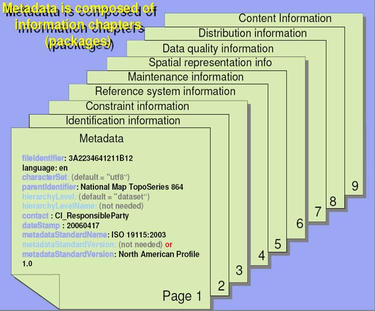
12 Metadata Standard - ISO 19115:2003 Recommended Core Metadata This list contains metadata elements answering the following questions: Does a dataset on a specific topic exist(what)? For a specific place(where)? For a specific date or period(when)? A point of contact to learn more about or order the dataset(who)? (M) Mandatory (M) Dataset title (M) Dataset reference date ( - ) Dataset responsible party (M) Geographic location of the dataset (by four coordinates or by geographic identifiers) (M) Dataset language (M) Dataset character set (M) Dataset topic category ( - ) Spatial Resolution ( - ) Abstract describing the dataset ( - ) Distribution format ( - ) Additional extent information (vertical and temporal) ( - ) Spatial representation type ( - ) Reference system ( - ) Lineage statement ( - ) On-line resource ( - ) Metadata file identifier ( - ) Metadata standard name ( - ) Metadata standard version (M) Metadata language (M) Metadata character set (M) Metadata point of contact (M) Metadata date stamp 12

13 Metadata packages - ISO 19115:

14 Metadata data dictionary 14
15 15
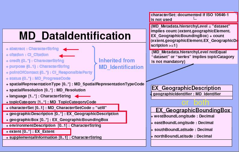
16 DataIdentification details 16
17 About Profile 17

18 What is a Profile? Profile A standard tailored for a Community 18
 (Conformance Level 1, Strict Conformance) Register Profiles Internationally Registered (ISP) Nationally Registered Published Profiles")
19 Standardized Profiles - ISO set of one or more base standards or sub-sets of base standards...that are necessary for accomplishing a particular function. Conformance to profile = conformance with base standard(s) (Conformance Level 1, Strict Conformance) Register Profiles Internationally Registered (ISP) Nationally Registered Published Profiles Formally within Community Informally within Organization 19


20 Profiles Regional, national & organizational Profiles Enable Interoperability Between Communities 20
 meeting decided to implement the")

21 Need for Asia Pacific Profile 8th PCGIAP(Permanent Committee on GIS Infrastructure for Asia and the pacific) meeting decided to implement the prototype of APSDI(Asia Pacific Spatial Data Infrastructure) clearinghouse. APSDI Clearinghouse is an environment that can facilitate access to geo-spatial data, products and services 21
22 History During 7 th PCGIAP Meeting, ,Tsukuba,Japana A task force for APSDI data node was formed Task: promoting the planning and implementation of APSDI spatial data clearinghouse. Started a pilot project Before 8 th PCGIAP Meeting, ,Brunei Darussalam Workshop on APSDI Clearinghouse (Hainan Islands, China, Nov. 2001); PCGIAP Metadata profile drafted; Guidelines for APSDI Clearinghouse Node Development drafted. 22
23 History (continued) Before 9 th PCGIAP meeting, ,Okinawa, Japan PCGIAP Metadata profile And a metadata entry tool named Mediator complying to this profile is developed and freely available. Guidelines for APSDI Clearinghouse Node Development finished and a reference prototype Implementation of APSDI Clearinghouse provided at Before 11 th PCGIAP Meeting, ,Bali, Indonesia Joint Workshop of WG1 and WG2,7-9 September 2004, Chengdu, China (Closed the pilot project and reinstituted the taskforce) ESRI GIS Portal Toolkit Workshop for PCGIAP, 6-8 April, 2005, Hong Kong, China (13 participants from 6 members; China, Indonesia, Japan, Korea, Nepal, Malaysia attended) 23

24 History (continued) 12 th PCGIAP & 17 th UNRCCAP, Tailand, 2006 Recommends PCGIAP encourage close collaboration between PCGIAP Working Group 2 with ISO/TC211 in the development of an ISO Metadata standard profile for Asia Pacific. 13th PCGIAP Meeting, June 2007 Seoul, Korea Metadata profile for AP Taskforce Coordinator: Prof. Sang-Ki Hong, Vice Chair of WG2 24
25 Recent Actions to make Asia Pacific Profile 13th PCGIAP Meeting, June 2007 Seoul, Korea Metadata profile for AP Taskforce (Coordinator: Prof. Sang-Ki Hong, Vice Chair of WG2) Use what has already been done by PCGIAP in the past Select latest ISO standards as the basis for this exercise Look at the profile already developed by the UN (UNGIWG) Connect the PCGIAP process with the one started by CODI and eventually PCIDEA Create a draft profile to be discussed among the members of PCGIAP Look at tools that could support the use of this profile Provide information and material to the members through the WG 2 web site Increase awareness through the organization of at least one workshop on metadata in the region Address the language issue (e.g.: glossary of terms, ISO) 25
26 Development of Asia Pacific Profile Selection of items from ISO19115:2003 Promotion of optional fields to mandatory Result of survey Other regional profile (NAP, LAMP, ANZLIC, INSPIRE & AFRICAN) Extension of code lists need to be worked Addition of values to existing code lists Addition of code lists 26

27 Development of Asia Pacific Profile Introduction of multilingual register need to be discussed Compliant to ISO19135:2005 on registers English and other languages Metadata items Code lists Register will be accessible on the Web - need to be worked XML document Web Services Web Browser 27
28 Survey Results 28
29 id name Obligation Ch+Vie+Mal+Hk VI I O 1 Metadata File Identifier O Language C Character Set C Parent Identifier Hierarchy Level Hierarchy Level Name contact M Date Stamp M Metadata Standard Name O Metadata Standard Version O Data Set URL Name Identification citation M 2-2 abstract M purpose credit 1-2 status Point Of Contact O
30 3 Data Identification Spatial Representation Type O Spatial Resolution O language M Character Set C Topic Category M Environment Description Extent Supplemental Information Browse Graphic File Name File Description File Type Keywords keyword O 3-1 Type Thesaurus Name
31 Analysis of Existing Profiles 31
32 19115 African ANZLIC/ Core UNGIWG INSPIRE AP 1 Metadata point of contact M M M M M M 2 Metadata date stamp M M M M M M 3 Metadata language C C C C M C 4 Metadata character set C C C C C 5 Metadata file identifier O O M C M 6 Metadata standard name O C O C O 7 Metadata standard version O C O C O 8 Dataset title M M M M M M Abstract describing the 9 dataset M M M M M M 10 Dataset reference date M M M M M M 11 Dataset language M M M M C M 12 Dataset topic category M M M M M M 13 Dataset character set C C C M C 14 Geographic location of the dataset (by four coordinates or by geographic identifier) C M C M M M 15 Dataset responsible party O M O M M M 16 Spatial resolution of the dataset O O O O C O 32
33 17 Additional extent information for the dataset (vertical O O O N M O and temporal) 18 Spatial representation O M O O O type 19 Distribution format O M O N O 20 On-line resource O C O O M O 21 Lineage O O O O M O 22 Reference system O O O C O Additional Elements purpose (M) Metadata file parent identifier (C) Dataset Edition (O) Presentation Format (C) Purpose (O) Status (C) Keywords (O) Place Keyword (M) Browse Graphic FileName (O) Browse Graphic FileDescription (O) Browse Graphic FileType (C) Start Date (O) End Date (O) SupplementalInformation (O) Maintenance Frequency (C) Restrictions (C) Data quality scope code (O) Processing step description (O) Processing step date/time stamp (O) Data quality report result (O) Geometric ObjectType (C) Cell Geometry (O) Keyword (M) Conformity (M) Conditions applying to access and use (M) Limitations on public access (M) purpose (O) keywords (O) restrictions (O) contraints(o) Positional Accuracy (O) fees (O) 33
34 Draft AP Metadata Profile 34
35 Name Path Obligation 1 Metadata point of contact MD_Metadata.contact > CI_ResponsibleParty M 2 Metadata date stamp MD_Metadata.dateStamp M 3 Metadata language MD_Metadata.language C 4 Metadata character set MD_Metadata.characterSet C 5 Metadata file identifier MD_Metadata.fileIdentifier M 6 Metadata standard name MD_Metadata.metadataStandardName O 7 Metadata standard version MD_Metadata.metadataStandardVersion O 8 Dataset title MD_Metadata.identificationInfo > MD_DataIdentification.citation > CI_Citation.title M 9 Abstract describing the dataset MD_Metadata.identificationInfo > MD_DataIdentification.abstract M 10 Purpose MD_Metadata.identificationInfo > MD_DataIdentification.purpose O 35
36 11 Keywords 12 Dataset reference date MD_Metadata.identificationInfo > MD_DataIdentification > MD_Keywords MD_Metadata.identificationInfo > MD_DataIdentification.citation > CI_Citation.date O M 13 Dataset language MD_Metadata.identificationInfo > MD_DataIdentification.language M 14 Dataset topic category MD_Metadata.identificationInfo > MD_DataIdentification.topicCategory M 15 Dataset character set MD_Metadata.identificationInfo > MD_DataIdentification.characterSet C Geographic location of MD_Metadata.identificationInfo > MD_DataIdentification.extent > the dataset (by four 16 EX_Extent > EX_GeographicBoundingBox or coordinates or by EX_GeographicDescription.geographicIdentifier geographic identifier) M Dataset responsible 17 party MD_Metadata.identificationInfo > MD_DataIdentification.pointOfContact > CI_ResponsibleParty M Spatial resolution of 18 the dataset Additional extent 19 information for the dataset MD_Metadata.identificationInfo > MD_DataIdentification.spatialResolution > MD_Resolution.distance or MD_Resolution.equivalentScale MD_Metadata.identificationInfo > MD_DataIdentification.extent > EX_Extent.temporalElement > EX_TemporalExtent.extent O O Spatial representation 20 type MD_Metadata.identificationInfo > MD_DataIdentification.spatialRepresentationType O 36
37 21 Distribution format MD_Metadata.distributionInfo > MD_Distribution > MD_Format O 22 Fees MD_Metadata.distributionInfo > MD_Distribution > MD_StandardOrderProcess.fees O 23 On-line resource MD_Metadata.distributionInfo > MD_Distribution > MD_DigitalTransferOption.onLine > CI_OnlineResource O 24 Lineage MD_Metadata.dataQualityInfo > DQ_DataQuality.lineage > LI_Lineage O 25 Source MD_Metadata.dataQualityInfo > DQ_DataQuality.lineage > LI_Lineage.source > LI_Source or LI_Lineage.processStep > LI_prossStep O 26 Positional Accuracy MD_Metadata.dataQualityInfo > DQ_DataQuality.report > DQ_Element > DQ_Positional_Accuracy O 27 Reference system MD_Metadata.referenceSystemInfo > MD_ReferenceSystem.referenceSystemIdentifier > RS_Identifier O 28 Contraints MD_Metadata.metadataConstrants > MD_Constraints > MD_LegalConstraints O 37
38 Issues 38

39 What kind of metadata? Minimum metadata is minimally useful 39
40 User requirement analysis Locate, evaluate, extract, employ Identification information Keywords may help refine search criteria in many situations Data quality information Is positional, temporal, or attribute accuracy; completeness, or consistency important in your user community? Content information Number of bands, features and attributes? Maintenance information Is update information important to your user community; for instance Navigation community Distribution information Will your community be using different distributors, formats, pricing fee? 40
41 Level of Constrain Elements Mandatory vs. Optional Should all data be at least optional? Don t eliminate any element from base standard. Does it against the idea of profile? ISO mandatory elements are constrained by the profiling rules. How many mandatory elements should we have? Absolutely minimum? or All elements that we think suitable? 41


?")
42 Scope of AP profile Which type do we need? Wide range profile : minimum/core set + full regional profile? Narrow range profile just one profile (with or without minimum set)? Base Standard 42
43 Further works things to do Code lists Expansion Implementation issues Services metadata Multiple language Issues AP Profile Documentation We need a dedicated Project Team! 43
44 Thank you for your attention! Contact info: 44
REPORT OF THE WORKING GROUP 2: FUNDAMENTAL DATA
 UNITED NATINS E/CNF.100/5 ECNMIC AND SCIAL CUNCIL Eighteenth United Nations Regional Cartographic Conference for Asia and the Pacific Bangkok, 26-29 ctober 2009 Item 5 of the provisional agenda Report
!"!!# GROUP SUBGROU. Entity and. Go-Geo! Metadata ISO ID FGDC ID. FGDC Name. ISO Name. Go-Geo! Definition. Elem ent ID.
 !"!!# GROUP SUBGROU P Entity and Elem ent ID Go-Geo! Metadata Entity and Element Names Go-Geo! Definition FGDC ID FGDC Name ISO Name ISO ID G1 CITATION Dataset reference information CITATION 1 Title 2
Croatian National Spatial Data Infrastructure Metadata Specification
 National Spatial Data Infrastructure Croatian National Spatial Data Infrastructure Metadata Specification Title: Version: 2.0 Creator: Croatian National Spatial Data Infrastructure Metadata Specification
What is the PCGIAP? Overview on PCGIAP Activities and the Asia/Pacific Region. Membership. Background. Aims. Asia-Pacific SDI
 3rd FIG Regional Conference for Asia and the Pacific Jakarta, Indonesia, 3-7th October 2004 Overview on PCGIAP Activities and the Asia/Pacific Region What is the PCGIAP? Haji Matusin Matasan Surveyor General,
Recent Topics regarding ISO/TC 211 in Japan
 Recent Topics regarding ISO/TC 211 in Japan KAWASE, Kazushige Geographical Survey Institute Ministry of Land, Infrastructure and Transport, Japan ISO/TC 211 Workshop on standards in action, Riyadh, Saudi
From PCGIAP to UN GGIM AP: A Regional Perspective on GGIM
 Regional Committee of United Nations Global Geospatial Information Management for Asia and the Pacific (UN-GGIM-AP) Established by a United Nations Resolution From PCGIAP to UN GGIM AP: A Regional Perspective
AS/NZS ISO :2015
 (ISO 19115-1:2014, IDT) Australian/New Zealand Standard Geographic information Metadata Part 1: Fundamentals Superseding AS/NZS ISO 19115:2005 AS/NZS ISO 19115.1:2015 This joint Australian/New Zealand
Report of PCGIAP to the 18 th United Nations Regional Cartographic Conference for Asia and the Pacific (UNRCC-AP) for the period
 for the period") Permanent Committee on GIS Infrastructure for Asia and the Pacific (PCGIAP) Established in 1995 by a United Nations Resolution Report of PCGIAP to the 18 th United Nations Regional Cartographic Conference
Permanent Committee on GIS Infrastructure for Asia and the Pacific (PCGIAP) Established in 1995 by a United Nations Resolution Report of PCGIAP to the 18 th United Nations Regional Cartographic Conference
Report of the Working Group 2 Data Sharing and Integration for Disaster Management *
 UNITED NATIONS E/CONF.104/6 ECONOMIC AND SOCIAL COUNCIL Twentieth United Nations Regional Cartographic Conference for Asia and the Pacific Jeju, 6-9 October 2015 Item 5 of the provisional agenda Report
Geografisk information Referensmodell. Geographic information Reference model
 SVENSK STANDARD SS-ISO 19101 Fastställd 2002-08-09 Utgåva 1 Geografisk information Referensmodell Geographic information Reference model ICS 35.240.70 Språk: engelska Tryckt i september 2002 Copyright
Spatially Enabled Society
 International Seminar on Land Administration Trends and Issues in Asia and the Pacific Region Spatially Enabled Society Abbas Rajabifard Vice Chair PCGIAP-WG3 Vice-President (President Elect), GSDI Association
Part 1: Fundamentals
 Provläsningsexemplar / Preview INTERNATIONAL STANDARD ISO 19101-1 First edition 2014-11-15 Geographic information Reference model Part 1: Fundamentals Information géographique Modèle de référence Partie
Analysis of Regional Fundamental Datasets Questionnaire
 Permanent Committee on GIS Infrastructure for Asia and the Pacific Working Group 2 Regional Fundamental Data Summary Report on Analysis of Regional Fundamental Datasets Questionnaire ABBAS RAJABIFARD and
DGIWG 200. Defence Geospatial Information Framework (DGIF) Overview
 Overview") DGIWG 200 Defence Geospatial Information Framework (DGIF) Overview Document type: Standard Document date: 28 November 2017 Edition: 2.0.0 Responsible Party: Audience: Abstract: Copyright: Defence Geospatial
DGIWG 200 Defence Geospatial Information Framework (DGIF) Overview Document type: Standard Document date: 28 November 2017 Edition: 2.0.0 Responsible Party: Audience: Abstract: Copyright: Defence Geospatial
ISO Plant Hardiness Zones Data Product Specification
 ISO 19131 Plant Hardiness Zones Data Product Specification Revision: A Page 1 of 12 Data specification: Plant Hardiness Zones - Table of Contents - 1. OVERVIEW...3 1.1. Informal description...3 1.2. Data
Reducing Consumer Uncertainty
 Spatial Analytics Reducing Consumer Uncertainty Eliciting User and Producer Views on Geospatial Data Quality Introduction Cooperative Research Centre for Spatial Information (CRCSI) in Australia Communicate
Background Document: Report of the Regional Committee of United Nations Global Geospatial Information Management for Asia and the Pacific
 Background Document: Report of the Regional Committee of United Nations Global Geospatial Information Management for Asia and the Pacific 1. Summary 1. This report highlights the activities carried out
The Time is Right to Commit to Use International Standards. Empowering Australia with Spatial Information
 The Time is Right to Commit to Use International Standards Empowering Australia with Spatial Information OUTLINE Energy Industry Metadata Standards Initiative ISO 19115 Revision Australian initiatives
Subwatersheds File Geodatabase Feature Class
 Subwatersheds File Geodatabase Feature Class Tags subwatersheds, watersheds Summary shows the subwatersheds of the 9 watersheds in TRCA's jurisdiction Description sub watershed boundaries in TRCA jurisdiction.
ISO INTERNATIONAL STANDARD. Geographic information Metadata Part 2: Extensions for imagery and gridded data
 INTERNATIONAL STANDARD ISO 19115-2 First edition 2009-02-15 Geographic information Metadata Part 2: Extensions for imagery and gridded data Information géographique Métadonnées Partie 2: Extensions pour
ISO INTERNATIONAL STANDARD. Geographic information Spatial referencing by coordinates
 INTERNATIONAL STANDARD ISO 19111 Second edition 2007-07-01 Geographic information Spatial referencing by coordinates Information géographique Système de références spatiales par coordonnées Reference number
Water Information System for Europe - WISE metadata profile
 Water Information System for Europe - WISE metadata profile EMWIS workshop Nice 08/09-06-2009 Jon Maidens, Atkins Danmark a/s * I think a brief introduction on WISE would be useful as most of the participants
Report of the Regional Committee of UN-GGIM for Asia and the Pacific (UN-GGIM-AP)
") Report of the Regional Committee of UN-GGIM for Asia and the Pacific (UN-GGIM-AP) At the Eighth Session of UN-GGIM UN Headquarters, New York, 1 3 August 2018 About UN-GGIM-AP One of the five regional committees
Report of the Regional Committee of UN-GGIM for Asia and the Pacific (UN-GGIM-AP) At the Eighth Session of UN-GGIM UN Headquarters, New York, 1 3 August 2018 About UN-GGIM-AP One of the five regional committees
INSPIRE - A Legal framework for environmental and land administration data in Europe
 INSPIRE - A Legal framework for environmental and land administration data in Europe Dr. Markus Seifert Bavarian Administration for Surveying and Cadastre Head of the SDI Office Bavaria Delegate of Germany
Roadmap to interoperability of geoinformation
 Roadmap to interoperability of geoinformation and services in Europe Paul Smits, Alessandro Annoni European Commission Joint Research Centre Institute for Environment and Sustainability paul.smits@jrc.it
Spatial Data Infrastructure Concepts and Components. Douglas Nebert U.S. Federal Geographic Data Committee Secretariat
 Spatial Data Infrastructure Concepts and Components Douglas Nebert U.S. Federal Geographic Data Committee Secretariat August 2009 What is a Spatial Data Infrastructure (SDI)? The SDI provides a basis for
TRCA_Jurisdiction. File Geodatabase Feature Class. Tags watersheds, boundary, trca
 Page 1 of 7 TRCA_Jurisdiction File Geodatabase Feature Class Tags watersheds, boundary, trca Summary Delineate TRCAs' administrative boundary as well as boundaries of watersheds within the jurisdiction
Some of the underlying goals of the GIS Library are to:
 1 2001 It was born out of the recognition that several of the regions prominent resource management agencies have similar, if not shared, requirements for GIS data. Some of the underlying goals of the
REPORT OF THE PERMANENT COMMITTEE ON GEOGRAPHICAL INFORMATION SYSTEM INFRASTRUCTURE FOR ASIA AND THE PACIFIC
 UNITED NATIONS E/CONF.97/3 ECONOMIC AND SOCIAL COUNCIL Seventeenth United Nations Regional Cartographic Conference for Asia and the Pacific Bangkok, 18-22 September 2006 Item 5 of the provisional agenda*
INSPIRE Monitoring and Reporting Implementing Rule Draft v2.1
 INSPIRE Infrastructure for Spatial Information in Europe INSPIRE Monitoring and Reporting Implementing Rule Draft v2.1 Title INSPIRE Monitoring and Reporting Implementing Rule v2.1 Creator DT Monitoring
NAG-City Expert Workshop Oslo 8-9. October 2012 SOSI standards and mapping for Europe (INSPIRE)
") NAG-City Expert Workshop Oslo 8-9. October 2012 SOSI standards and mapping for Europe (INSPIRE) Per Ryghaug, Geomatics The Norwegian national standard on geographic information - SOSI Started in 1984 NGU
NAG-City Expert Workshop Oslo 8-9. October 2012 SOSI standards and mapping for Europe (INSPIRE) Per Ryghaug, Geomatics The Norwegian national standard on geographic information - SOSI Started in 1984 NGU
Working Group 3 on Regional SDI. Activity Report. for. The 5th UN-GGIM-AP Plenary Meeting
 Regional Committee of United Nations Global Geospatial Information Management for Asia and the Pacific (UN-GGIM-AP) Working Group 3 on Regional SDI Activity Report for The 5th UN-GGIM-AP Plenary Meeting
UNITED NATIONS E/CONF.97/6/IP. 8
 UNITED NATIONS E/CONF.97/6/IP. 8 ECONOMIC AND SOCIAL COUNCIL Seventeenth United Nations Regional Cartographic Conference for Asia and the Pacific Bangkok, 18-22 September 2006 Item 7 of the provisional
ISO Daily 10 km Gridded Climate Dataset for Canada ( ) Data Product Specifications. Revision: A
 Data Product Specifications. Revision: A") ISO 19131 Daily 10 km Gridded Climate Dataset for Canada (1950-2012) Data Product Specifications Revision: A Data product specifications: Daily 10 km Gridded Climate Dataset for Canada (1950-2012) - Table
ISO 19131 Daily 10 km Gridded Climate Dataset for Canada (1950-2012) Data Product Specifications Revision: A Data product specifications: Daily 10 km Gridded Climate Dataset for Canada (1950-2012) - Table
ISO INTERNATIONAL STANDARD. Geographic information Metadata Part 2: Extensions for imagery and gridded data
 INTERNATIONAL STANDARD ISO 19115-2 First edition 2009-02-15 Geographic information Metadata Part 2: Extensions for imagery and gridded data Information géographique Métadonnées Partie 2: Extensions pour
Working Group 1. Geodetic Reference Frame. Activity Report. for. The UN-GGIM-AP Plenary Meeting
 Regional Committee of United Nations Global Geospatial Information Management for Asia and the Pacific (UN-GGIM-AP) Established by a United Nations Resolution Working Group 1 Geodetic Reference Frame Activity
Express Bus Stops, New York NY, Nov 2018
 Metadata format: ISO 19139 Express Bus Stops, New York NY, Nov 2018 ISO 19139 metadata content Resource Identification Information Spatial Representation Information Reference System Information Data Quality
Report for 15th PCGIAP Meeting at 18th UNRCC-AP Working Group 1 Regional Geodesy
 Report for 15th PCGIAP Meeting at 18th UNRCC-AP Working Group 1 Regional Geodesy Chairman Shigeru Matsuzaka, Japan - shigeru@gsi.go.jp Vice Chairman Prof. Pengfei Cheng, China - chengpf@casm.ac.cn John
Status of interoperability issues in the Chilean SDI. Álvaro Monett Pablo Morales Executive Secretariat NSDI-Chile
 Status of interoperability issues in the Chilean SDI Álvaro Monett Pablo Morales Executive Secretariat NSDI-Chile Outline Background - Chilean SDI working areas Background Interoperability, standards and
The Integration of Land and Marine Spatial Data Set As Part of Indonesian Spatial Data Infrastructure Development
 UNITED NATIONS E/CONF.97/6/IP. 46 ECONOMIC AND SOCIAL COUNCIL Seventeenth United Nations Regional Cartographic Conference for Asia and the Pacific Bangkok, 18-22 September 2006 Item 7 of the provisional
Portals: Standards in Action
 Portals: Standards in Action David Danko ISO TC 211 Metadata Project Leader GIS Standards Consultant-ESRI. Metadata Portals Portal gateway, place of entry Producers Advertise, expose products Share information
Activities relating to the Working Group on Toponymic Data Files and Gazetteers*
 UNITED NATIONS WORKING PAPER GROUP OF EXPERTS NO. 10 ON GEOGRAPHICAL NAMES Twenty-seventh session 30 July and 10 August 2012, New York Item 3 of the Provisional Agenda Reports of the working groups Activities
2nd Joint SIG 3D and OGC Workshop - CityGML EnergyADE for building energy calculation. Working group metadata
 2nd Joint SIG 3D and OGC Workshop - CityGML EnergyADE for building energy calculation Working group metadata TOC Metadata standards for spatial data CityGML Metadata discussion at SIG3D and OGC Closer
Staten Island Bus Stops, New York NY, May 2016
 Page 1 of 6 Metadata format: ISO 19139 Staten Island Bus Stops, New York NY, May 2016 ISO 19139 metadata content Resource Identification Information Spatial Representation Information Reference System
CUNY Tax Lots, New York NY, Sept 2016
 Page 1 of 6 Metadata format: ISO 19139 CUNY Tax Lots, New York NY, Sept 2016 ISO 19139 metadata content Resource Identification Information Spatial Representation Information Reference System Information
Think Local - Act Global a Nordic Perspective
 Think Local - Act Global a Nordic Perspective OGC Nordic Forum Jari Reini 20-21.5.2014 OGC Nordic Forum? OGC Nordic Forum addresses OGC outreach and education needs of government, academic, research and
ICSM delivering benefits through collaboration
 ICSM delivering benefits through collaboration Russell Priebbenow Chair and Queensland Member Australia and New Zealand s Intergovernmental Committee on Surveying and Mapping Overview Who is ICSM & why
Upgrade the Datasets in NSDI for Smarter Services with the Cases of China
 Upgrade the Datasets in NSDI for Smarter Services with the Cases of China By Dr. JIANG Jie Dept of GeoInformaiton Service Platform National Geomatics Center of China October 7, 2015 Jeju, Republic of Korea
SA/SNZ TS ISO :2015
 (ISO/TS 19130-2:2014, IDT) Australian/New Zealand Technical Specification Geographic information Imagery sensor models for geopositioning Part 2: SAR, InSAR, lidar and sonar SA/SNZ TS ISO 19130.2:2015
Presentation of the Cooperation Project goals. Nicola Ferrè
 Presentation of the Cooperation Project goals Nicola Ferrè Project goals Capacity development for implementing a Geographic Information System (GIS) applied to surveillance, control and zoning of avian
Finding geodata that otherwise would have been forgotten GeoXchange a portal for free geodata
 Finding geodata that otherwise would have been forgotten GeoXchange a portal for free geodata Sven Tschirner and Alexander Zipf University of Applied Sciences FH Mainz Department of Geoinformatics and
DVRPC's 2010 and 2040 Transit Score
 Page 1 of 12 DVRPC's 2010 and 2040 Transit Score Shapefile Tags Transit Score, TAZ Summary To be used for planning purposes. Description This two-phase project defines a method to assess the appropriateness
ISO Canadian Drought Monitor Data Product Specifications
 ISO 19131 Canadian Drought Monitor Data Product Specifications Revision: A Page 1 of 14 Data product specifications: Canadian Drought Monitor - Table of Contents- 1. Overview... 3 1.1. Informal description...
COMMISSION 3 SPATIAL INFORMATION MANAGEMENT WORK PLAN
 Appendix to item 34.3 FIG Congress in Washington, 19-26 April 2002 COMMISSION 3 SPATIAL INFORMATION MANAGEMENT WORK PLAN 2002 2006 1. Title Spatial Information Management. 2. Terms of Reference - Management
Previous discussion. ECSA Data Tools & Technology WG ENVIP 2015
 Previous discussion ECSA Data Tools & Technology WG ENVIP 2015 Introduction Where we are and were do we want to go? Comparison: Computer Networks and Citizen Science Networks Topics to develop Conceptual
INSPIRE implementation in Portugal: the operational approach
 INSPIRE implementation in Portugal: the operational approach REIS, Rui; SANTOS, Ana Sofia; FONSECA, Alexandra; SILVA, Henrique; GOMES, Ana Luisa; FURTADO, Danilo; GEIRINHAS, João rui.reis@igeo.pt AGENDA
INSPIRE Directive. Status June 2007
 INSPIRE Directive INfrastructure for SPatial InfoRmation in Europe Status June 2007 European Commission Directorate-General Environment Research, Science and Innovation Unit Rue de la Loi, 200 1049 Brussels
Technical Specifications. Form of the standard
 Used by popular acceptance Voluntary Implementation Mandatory Legally enforced Technical Specifications Conventions Guidelines Form of the standard Restrictive Information System Structures Contents Values
Subway Station Entrances, New York NY, May 2016
 Page 1 of 6 Metadata format: ISO 19139 Subway Station Entrances, New York NY, May 2016 ISO 19139 metadata content Resource Identification Information Spatial Representation Information Reference System
Use of the ISO Quality standards at the NMCAs Results from questionnaires taken in 2004 and 2011
 Use of the ISO 19100 Quality standards at the NMCAs Results from questionnaires taken in 2004 and 2011 Eurogeographics Quality Knowledge Exchange Network Reference: History Version Author Date Comments
New York City Public Use Microdata Areas (PUMAs) for 2010 Census
 for 2010 Census") New York City Public Use Microdata Areas (PUMAs) for 2010 Census ESRI Shapefile Tags PUMA, Public Use Microdata Area, Census, New York, Manhattan, Queens, Brooklyn, Richmond, Bronx, Kings, Staten Island,
New York City Public Use Microdata Areas (PUMAs) for 2010 Census ESRI Shapefile Tags PUMA, Public Use Microdata Area, Census, New York, Manhattan, Queens, Brooklyn, Richmond, Bronx, Kings, Staten Island,
UBGI and Address Standards
 Workshop on address standards UBGI and Address Standards 2008. 5.25 Copenhagen, Denmark Sang-Ki Hong Convenor, WG 10 1 Evolution of Geographic Information Visualization Feature (Contents) Context Accessibility
Global Geospatial Information Management Country Report Finland. Submitted by Director General Jarmo Ratia, National Land Survey
 Global Geospatial Information Management Country Report Finland Submitted by Director General Jarmo Ratia, National Land Survey Global Geospatial Information Management Country Report Finland Background
New York City Council Districts Water Included
 City Council Districts Water Included ESRI Shapefile Tags Queens, City, City Council, Richmond, boundaries, Kings, Brooklyn, Bronx,, Political Boundaries, Staten Island, Manhattan Summary These districts
THE WASHINGTON COASTAL ATLAS
 THE ICAN COASTAL ATLAS MEDIATOR PROTOTYPE AND CONNECTING THE WASHINGTON COASTAL ATLAS Liz O Dea 1, Yassine Lassoued 2, Tanya Haddad 3, Declan Dunne 2 1 GIS Services Unit, WA State Dept. of Ecology 2 Coastal
A Data Repository for Named Places and Their Standardised Names Integrated With the Production of National Map Series
 A Data Repository for Named Places and Their Standardised Names Integrated With the Production of National Map Series Teemu Leskinen National Land Survey of Finland Abstract. The Geographic Names Register
Data Origin. Ron van Lammeren CGI-GIRS 0910
 Data Origin Ron van Lammeren CGI-GIRS 0910 How to obtain geodata? Geo data initiative Executive Order 12906, "Coordinating Geographic Data Acquisition and Access: The National Spatial Data Infrastructure,"
Joint RA II/V Workshop on WIGOS for DRR - The Jakarta Declaration - (12-14 October, Jakarta, Indonesia) NMSC/KMA
 NMSC/KMA") Joint RA II/V Workshop on WIGOS for DRR - The Jakarta Declaration - (12-14 October, Jakarta, Indonesia) /KMA dolong@korea.kr Background Enhancement of Member s capabilities for weather forecasts and warnings
Joint RA II/V Workshop on WIGOS for DRR - The Jakarta Declaration - (12-14 October, Jakarta, Indonesia) /KMA dolong@korea.kr Background Enhancement of Member s capabilities for weather forecasts and warnings
19.2 Geographic Names Register General The Geographic Names Register of the National Land Survey is the authoritative geographic names data
 Section 7 Technical issues web services Chapter 19 A Data Repository for Named Places and their Standardised Names Integrated with the Production of National Map Series Teemu Leskinen (National Land Survey
Bus Routes, New York NY, August 2017
 Page 1 of 6 Metadata format: ISO 19139 Bus Routes, New York NY, August 2017 ISO 19139 metadata content Resource Identification Information Spatial Representation Information Reference System Information
ISO and CEN Standardization work Trond Hovland NPRA. Norwegian Public Roads Administration
 ISO and CEN Standardization work Trond Hovland NPRA Agenda Short general information on NRDB ISO TC211 and TC204 CEN and domestic standards Status and Summing-Up Agenda Short general information on NRDB
Data Origin. How to obtain geodata? Ron van Lammeren CGI-GIRS 0910
 Data Origin How to obtain geodata? Ron van Lammeren CGI-GIRS 0910 Spatial Data interest Improvement of policy making. ± 90% of all information used by government has spatial characteristics SPATIAL INFORMATION
File Geodatabase Feature Class. Tags platts, price assessement, crude oil, crude, petroleum
 Major Price Assessment Points (Global) File Geodatabase Feature Class Tags platts, price assessement, crude oil, crude, petroleum Summary Visualize the price of oil around the world with these generalized
2007 / 2008 GeoNOVA Secretariat Annual Report
 2007 / 2008 GeoNOVA Secretariat Annual Report Prepared for: Assistant Deputy Minister and Deputy Minister of Service Nova Scotia and Municipal Relations BACKGROUND This report reflects GeoNOVA s ongoing
Creating A-16 Compliant National Data Theme for Cultural Resources
 Creating A-16 Compliant National Data Theme for Cultural Resources Cultural Resource GIS Facility National Park Service John J. Knoerl Deidre McCarthy Paper 169 Abstract OMB Circular A-16 defines a set
8 th Arctic Regional Hydrographic Commission Meeting September 2018, Longyearbyen, Svalbard Norway
 8 th Arctic Regional Hydrographic Commission Meeting 11-13 September 2018, Longyearbyen, Svalbard Norway Status Report of the Arctic Regional Marine Spatial Data Infrastructures Working Group (ARMSDIWG)
LIRR Routes, New York NY, May 2016
 Page 1 of 6 Metadata format: ISO 19139 LIRR Routes, New York NY, May 2016 ISO 19139 metadata content Resource Identification Information Spatial Representation Information Reference System Information
A GIS helps you answer questions and solve problems by looking at your data in a way that is quickly understood and easily shared.
 WHAT IS GIS? A geographic information system (GIS) integrates hardware, software, and data for capturing, managing, analyzing, and displaying all forms of geographically referenced information. GIS allows
Spatial data interoperability and INSPIRE compliance the platform approach BAGIS
 Spatial data interoperability and INSPIRE compliance the platform approach BAGIS BAGIS Voluntary, independent, public, non-profit organization; Organization with main mission to promote the growth of the
Recommendations for INSPIRE Spatial Data Services
 INSPIRE Infrastructure for Spatial Information in Europe Recommendations for INSPIRE Spatial Data Services Title Creator Recommendations for INSPIRE Spatial Data Services Spatial Data Services Working
LIRR Routes, New York NY, January 2017
 Page 1 of 6 Metadata format: ISO 19139 LIRR Routes, New York NY, January 2017 ISO 19139 metadata content Resource Identification Information Spatial Representation Information Reference System Information
Geographic Information Standards CWP Harmonization outlooks
 Geographic Information Standards CWP Harmonization outlooks Emmanuel Blondel (FAO) emmanuel.blondel@fao.org 1 Outline CWP GIS working group Objectives & activities GIS data survey summary & outputs Activity
NOKIS - Information Infrastructure for the North and Baltic Sea
 NOKIS - Information Infrastructure for the North and Baltic Sea Carsten Heidmann 1 and Jörn Kohlus 2 Abstract 1. General The initial motivation for the project NOKIS (German title: Nord- und Ostsee-Küsteninformationssystem)
Ready for INSPIRE.... connecting worlds. European SDI Service Center
 Ready for INSPIRE Consultancy SOFTWARE T r a i n i n g Solutions... connecting worlds European SDI Service Center Increasing Added Value with INSPIRE and SDI Components INSPIRE In 2007, the European Commission
Recommendations for INSPIRE Spatial Data Services
 INSPIRE Infrastructure for Spatial Information in Europe Recommendations for INSPIRE Spatial Data Services Title Creator Recommendations for INSPIRE Spatial Data Services Spatial Data Services Working
TECHNICAL REPORT ISO/TR Geographic information Functional standards. Information géographique Normes fonctionnelles. First edition
 TECHNICAL REPORT ISO/TR 19120 First edition 2001-07-01 Geographic information Functional standards Information géographique Normes fonctionnelles Reference number ISO 2001 Provläsningsexemplar / Preview
Utilization of Global Map for Societal Benefit Areas
 Utilization of Global Map for Societal Benefit Areas The Fourth GEOSS AP Symposium Bali Indonesia, 11th March 2010 Shuhei Kojima Geographical Survey Institute Ministry of Land, Infrastructure, Transport
INSPIREd solutions for Air Quality problems Alexander Kotsev
 INSPIREd solutions for Air Quality problems Alexander Kotsev www.jrc.ec.europa.eu Serving society Stimulating innovation Supporting legislation The European data puzzle The European data puzzle 24 official
The INSPIRE Community Geoportal
 Infrastructure for Spatial Information in the European Community The INSPIRE Community Geoportal Gianluca Luraschi EC INSPIRE GEOPORTAL TEAM European Commission Joint Research Centre Institute for Environment
EXPECTATIONS OF TURKISH ENVIRONMENTAL SECTOR FROM INSPIRE
 EXPECTATIONS OF TURKISH ENVIRONMENTAL SECTOR FROM INSPIRE June, 2010 Ahmet ÇİVİ Tuncay DEMİR INSPIRE in the Eyes of MoEF Handling of Geodata by MoEF Benefits Expected TEIEN First Steps for INSPIRE Final
SDI Standards at work
 SDI Standards at work Jan Juul Jensen Senior Technology Strategist Informi GIS Denmark Informi GIS Private held Limited Company Specialized in GIS 100+ employees HQ in Charlottenlund, Copenhagen Regional
ISO INTERNATIONAL STANDARD. Geographic information Spatial referencing by coordinates Part 2: Extension for parametric values
 INTERNATIONAL STANDARD ISO 19111-2 First edition 2009-08-15 Geographic information Spatial referencing by coordinates Part 2: Extension for parametric values Information géographique Système de références
SWEDISH SDI DEVELOPMENT & IMPLEMENTATION OF INSPIRE
 SWEDISH SDI DEVELOPMENT & IMPLEMENTATION OF INSPIRE Christina Wasström, Lantmäteriet, 801 82 Gävle, Sweden, christina.wasstrom@lm.se ABSTRACT The Swedish Government and Parliament has given Lantmäteriet
Lower Density Growth Management Metadata
 Products > BYTES of the BIG APPLE TM Lower Density Growth Management Metadata nyldgma Data Format: Shapefile File or table name: nyldgma Data Projection: NAD_1983_StatePlane_New_York_Long_Island_FIPS_3104_Feet
econtentplus GS Soil
 econtentplus GS Soil General aims Assessment and strategic development of INSPIRE compliant Geodata-Services for European Soil Data BPN on basis of the EU 2007/2/EC (INSPIRE) Directive for Annex III theme
Economic and Social Council
 United Nations Economic and Social Council Distr.: General 23 May 2012 Original: English E/CONF.101/100 Tenth United Nations Conference on the Standardization of Geographical Names New York, 31 July 9
The future of SDIs. Ian Masser
 The future of SDIs Ian Masser Presentation Considers two questions relating to the future development of SDIs throughout the world Where have we got to now? Where should we go from here? Identifies four
ESBN. Working Group on INSPIRE
 ESBN Working Group on INSPIRE by Marc Van Liedekerke, Endre Dobos and Paul Smits behalf of the WG members WG participants Marc Van Liedekerke Panos Panagos Borut Vrščaj Ivana Kovacikova Erik Obersteiner
Hosted by Esri Official Distributor
 Hosted by Esri Official Distributor Esri European User Conference October 15-17, 2012 Oslo, Norway Hosted by Esri Official Distributor Interoperability and Standards Support in ArcGIS 10.1 Roberto Lucchi
Minnesota Geographic Metadata Guidelines. Metadata Entry Template. Version July 1, 1997
 Minnesota Geographic Metadata Guidelines Metadata Entry Template Version 1.0.4 - July 1, 1997 A State Version of the FGDC Content Standards for Geospatial Metadata *** Description of data that was created