Water Information System for Europe - WISE metadata profile
|
|
|
- John Carter
- 5 years ago
- Views:
Transcription

1 Water Information System for Europe - WISE metadata profile EMWIS workshop Nice 08/ Jon Maidens, Atkins Danmark a/s
2 * I think a brief introduction on WISE would be useful as most of the participants might not be familiar with it (coming from non EU countries). You can show some outputs such as indicators or maps, if possible with examples of data provided by country on voluntary basis rather than mandatory due to the WFD or other directives (there is no obligation for non EU Med countries) * Introducing QA / QC processes might also be relevant, if you have enough time, showing that it is necessary for WISE but also an added value for countries * the geographical reference data sets proposed in the guidance document * The role of metadata into WISE * the WISE metadata profile: it would be good if you could present briefly all the elements. Is that ok for you? * Next steps on metadata management within WISE
3 Overview
4 Atkins Large international consultancy EEA GIS framework contract Commission contract from October 2008 to provide technical support to WFD implementation River Basin Management Plans
5 Overview of the session WISE overview Reference data in WISE Metadata in WISE How the metadata is structured Next steps with WISE and metadata
6 Water Information System for Europe (WISE)

7 Key WISE principles Common approach to how water related data and geogrpahic information is gathered, reported and shared Agreed and implemented in cooperation with DG Environment, JRC, Eurostat and EEA Developing a distributed system by 2010 linking to the member states Implementation plan until 2010 Bringing together SoE and compliance reporting Merging water related directives and the needed data work (Water Framework Directive (WFD), UWWT, Bathing, Nitrates, water statistics...) Provide data and information to the public
8 WISE evolution DG Environment and Member States stakeholders Working/Technical/Steering groups WISE GIS Guidance CIS Guidance document no. 22

9 WISE integration circle Euro-Mediterranean

10 Role of EEA European water data center Provider of thematic content
11 WISE Inputs Water Framework Directive UWWTD Directive Bathing Water Directive WISE SoE Other water related information in Europe Electronic reporting - defined information to report through schemas/data dictionaries
12 WISE Outputs WISE mapviewer released in 2007 Services planned Data viewer/download functionality Distributed network (metadata component critical)

13 WISE viewer

14 WISE viewer
15 WISE MS service layer
16 WISE adding value Streamlining Interoperability European picture - harmonization Link to local picture Quality control/assurance - validation
17 WISE SoE voluntary reporting The EEA bases its water quality data on a representative sub-sample of national monitoring results, which EEA member countries report voluntarily each year to the EEA. The EEA has mainly collected annual values (e.g. average, median, minimum and maximum). Transition from Eionet-Water to WISE-SoE reporting has already been done for water quality related determinands for rivers, lakes and groundwater. The aim is a delivery of one dataset that might be useful for both WFD compliance by the European Commission services and EEA SoE assessments.


18 Nitrate by river basin districts Mean annual concentrations of nitrate measured at Eionet- Water River monitoring stations, by river basin districts Good agreement between nitrate map and regions of intensive agricultural land
 high pollution levels are Belgium and")
19 Total ammonia reduction and increase Policy relevant trends: low pollution levels sparsely populated northern countries and in the Alps (Austria) high pollution levels are Belgium and Poland
20 Geographical reference data sets
21 Purpose Integral part of WISE Created using detailed digital spatial data provided by Member States and other sources, generalised for the purposes of visualisation and assessment of geo-referenced data across Europe. Thematic data can be attached or linked to WISE Reference GIS datasets; Relatively stable over time Currently five WISE Reference GIS datasets
22 Principles The process of preparing the datasets using data provided by MS will be transparent for MS; MS will be contacted to ensure the correct interpretation and use of submitted data. The WISE Reference GIS dataset will be released for further use by EC through the WISE portal; WISE Reference GIS datasets will be provided for download. They will be published with a version number and time stamp. Furthermore, detailed documentation of data sources of the respective WISE Reference GIS dataset will be available; WISE Reference GIS datasets will be published in the WISE viewer.
23 Types of reference layers Hydrological infrastructure layers describe the features of the physical hydrological system, e.g. rivers, lakes and river basins. Water management layers describe the hydrological features from a management perspective that allow the aggregation of features across river basin boundaries, e.g. River Basin Districts and water bodies.
24 Current WISE Reference GIS datasets Large Rivers and Large Lakes; Main Rivers and Main Lakes; Water Bodies; River Basin Districts; Sub-units.

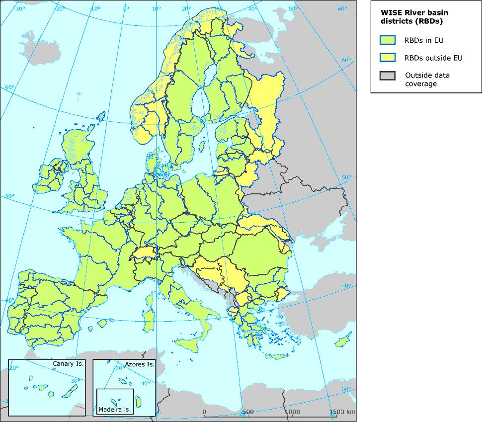
25 River Basin Districts
26 Purpose of Reference datasets (I) Visualisation: through the WISE Viewer it is possible to display features reported by Member States, the results of any analysis of the data, or a combination of any information available. Analysis: the data reported by Member States and contained in WISE can be used for analysis and assessment (compliance checking, policy effectiveness, modelling of scenarios for policy development, etc). Indicators can be determined at various levels. They should be produced using methodologies that are robust and transparent in agreement with the Member States
27 Purpose of Reference datasets (II) Reporting: future reporting exercises should be linked with the WISE Reference GIS datasets. Integrity and consistency of codes should be maintained. For example, whenever a Member State reports a river monitoring station, it should be located on and linked by code with its associated river water body.
28 Metadata in WISE
29 Scope Implementation of Water Framework Directive Wise Implementation Defined set of metadata primarily for data exchange Metadata publication (catalogue services) Purpose Data discovery Data usage Application Spatial datasets, Dataset series, Services Compliance with INSPIRE proposal on metadata implementing rules
30 Which WISE components require metadata? Metadata should be created with all geographical information being reported to, developed in the context of, or disseminated through WISE. A sub-set of the metadata elements found in the WISE profile for spatial data would also be applicable for nonspatial data submitted by Member States.
31 Metadata principles (I) The WISE metadata profile should support the functions of discovery and usage. Since the majority of WISE datasets and services fall under the scope of INSPIRE, the profile extends the INSPIRE metadata to include all those additional elements already agreed by the WISE community. Use of INSPIRE terminology for element names wherever possible, thus ensuring compatibility with metadata created in other environmental policy areas.
32 Metadata principles (II) The INSPIRE metadata elements have been selected to support the primary function of discovery. For 10 categories, there are a total of 27 metadata elements. It is important to note that whilst in general INSPIRE advocates the use of recognised standards it is not a requirement to fulfil the obligations of the INSPIRE metadata regulation to adopt ISO19115 or related standards for implementation.
33 WISE metadata profile
34 1. Identification WISE WISE Element Name Resource title INSPIRE INSPIRE MD cross reference 1.1 Obligation / condition Mandatory Multiplicity [1] ISO ISO19115/19119 cross reference Title Data type Domain Example CharacterString Free text WISE River basin districts Implementing instructions Should be kept short. Short guidance should specify the title to be used in reporting
35 1. Identification WISE WISE Element Name Resource abstract INSPIRE INSPIRE MD cross reference 1.2 Obligation / condition Mandatory Multiplicity [1] ISO ISO19115/19119 cross reference abstract Data type Domain Example CharacterString Free text Water Framework Directive (WFD) Article 3 river basin districts (RBDs) v1.3. Definition in WFD: River basin district means the area of land and sea, made up of one or more neighbouring river basins together with their associated groundwaters and coastal waters, which is identified under Article 3(1) as the main unit for management of river basins. Implementing instructions Short guidance should specify the text to be used in reporting. Include references to directives, conventions, etc.
36 1. Identification WISE WISE Element Name Resource type INSPIRE INSPIRE MD cross reference 1.3 Obligation / condition Mandatory Multiplicity [1] ISO ISO19115/19119 cross reference hierarchylevel Data type Domain Example MD_ScopeCode CodeList Dataset Implementing instructions For INSPIRE, three of the 17 ScopeCode values are used : Dataset for spatial datasets Series for spatial dataset series Services for spatial data services Short guidance should specify the code to be used in reporting
37 1. Identification WISE WISE Element Name Resource locator INSPIRE INSPIRE MD cross reference 1.4 Obligation / condition Conditional for spatial datasets and spatial dataset series: Mandatory if a URL is available to obtain more information on the resources and/or access related services. Conditional for services: Mandatory if linkage to the service is available. Multiplicity [0..*] ISO ISO19115/19119 cross reference linkage Data type URL Domain URL Example Implementing instructions Specify a valid URL to the resource. If no direct link to a resource is available, provide link to a contact point where more information about the resource is available. [contd in Appendix 11]
38 1. Identification WISE WISE Element Name Unique resource identifier INSPIRE INSPIRE MD cross reference 1.5 Obligation / condition Mandatory Multiplicity [1..*] ISO ISO19115/19119 cross reference Identifier Data type MD_Identifier Implementing instructions Domain See B of ISO The code property is required at a minimum, and a codespace property may be provided. Example Code: codespace: None
39 1. Identification WISE WISE Element Name Coupled resource INSPIRE INSPIRE MD cross reference 1.5 Obligation / condition Mandatory Multiplicity [1..*] ISO ISO19115/19119 cross reference Identifier Data type MD_Identifier Implementing instructions Domain See B of ISO The code property is required at a minimum, and a codespace property may be provided. Example Code: codespace: None
40 1. Identification WISE WISE Element Name Couple d resource INSPIRE INSPIRE MD cross reference 1.6 Obligation / condition o Not applicable to dataset and dataset series o Conditional to services: Mandatory if linkage to datasets on which the service operates are available. Multiplicity [0..*] ISO ISO19115/19119 cross reference identificationinfo[1]/*/operateson Data type MD_DataIdentification Domain A unique resource identifier or locator of the MD_DataIdentification object. Example Implementing instructions The property shall be implemented by reference and the MD_DataIdentification object reference value is the code of the Coupled resource metadata element. For consistency, the code of the Coupled resource metadata element should also be the code of one of the Unique resource identifiers of the corresponding coupled resource.
41 1. Identification WISE WISE Element Name Resource language INSPIRE INSPIRE MD cross reference 1.7 Obligation / condition Conditional for spatial dataset and spatial dataset series: Mandatory if the resource includes textual information. Not applicable to services. Multiplicity [0..*] ISO ISO19115/19119 cross reference Language Data type LanguageCode (ISO/TS 19139) Domain Example CodeList (See ISO/TS 19139) based on alpha-3 codes of ISO dan Implementing instructions An instance of the language property is mandated by ISO19115; it can be defaulted to the value of the Metadata Language when the dataset or the dataset series does not contain textual information.
42 2. Classification of spatial datasets and services WISE WISE Element Name Topic category INSPIRE INSPIRE MD cross reference 2.1 Obligation / condition Mandatory for dataset and dataset series. Not applicable to services. Multiplicity [1..*] ISO ISO19115/19119 cross reference topiccategory Data type MD_TopicCategory Domain Enumeration (See B.5.27 of ISO 19115) Example inlandwaters Implementing instructions The topic categories defined in Part D2 of the INSPIRE Implementing Rules for metadata are derived directly from the topic categories defined in B.5.27 of ISO INSPIRE Implementing Rules for metadata define the INSPIRE data themes to which each topic category is applicable, i.e. Administrative units (I.4) and Statistical units (III.1) are INSPIRE themes for which the boundaries topic category is applicable.
43 2. Classification of spatial datasets and services WISE WISE Element Name Spatial data service type INSPIRE INSPIRE MD cross reference 2.2 Obligation / condition Not applicable to dataset and dataset series. Mandatory for services. Multiplicity [1] ISO ISO19115/19119 cross reference identificationinfo[1]/*/servicetype Data type GenericName Domain The list below defines an initial set of possible values of the servicetype property. OGC:CSW for Discovery Service OGC:WMS for View Service OGC:WFS or OGC:WCS for Download Service OGC:WCTS for Transformation Service OGC:WPS for Invoke Spatial Data Service Any non registered value for Other Services Example OGC:CSW (the corresponding INSPIRE value is Discovery Service) Implementing instructions None
44 3. Keyword value WISE WISE Element Name Keyword value INSPIRE INSPIRE MD cross reference 3.1 Obligation / condition Mandatory Multiplicity ISO ISO19115/19119 cross reference Keyword [1] relative to a single keyword, but there may be many keywords, with each a different keyword value, originating from one or many different controlled vocabularies. Data type Domain Example CharacterString Free text Water Framework Directive, Article 3, River Basin Districts Implementing instructions Each instance of ISO keyword may originate from a controlled vocabulary described through the thesaurusname property of the instance of descriptivekeywords to which the keyword pertains. Short guidance should specify the keywords to be used in reporting
45 3. Keyword value WISE WISE Element Name Originating controlled vocabulary INSPIRE INSPIRE MD cross reference 3.2 Obligation / condition Conditional: Mandatory if the keyword value originates from a controlled vocabulary. Multiplicity [0..1] relative to a single Keyword, but there may be many keywords originating from different controlled vocabularies. ISO ISO19115/19119 cross reference ThesaurusName Data type CI_Citation Implementing instructions Domain The following properties are expected: Title of type CharacterString (Free text) Reference date defined as: o A date type: creation, revision or publication o An effective date Example Title: GEMET Thesaurus version 1.0 Date: o datetype: publication o date: GEMET should be prescribed for WISE reporting
46 4. Geographic location WISE WISE Element Name Geographic bounding box INSPIRE INSPIRE MD cross reference 4.1 Obligation / condition Mandatory for spatial dataset and dataset series. Conditional for spatial services: Mandatory for services with an explicit geographic extent. Multiplicity [1..*] for spatial dataset and spatial dataset series [0..*] for spatial data services ISO ISO19115/19119 cross reference westboundlongitude eastboundlongitude southboundlatitude northboundlatitude Data type Decimal Domain westboundlongitude eastboundlongitude southboundlatitude northboundlatitude southboundlatitude northboundlatitude Example [contd in Appendix 11] Implementing instructions
47 5. Temporal reference WISE WISE Element Name Temporal extent INSPIRE INSPIRE MD cross reference 5.1 Obligation / condition Multiplicity Conditional: At least one temporal reference is required. [0..*] but at least one temporal reference is required. ISO ISO19115/19119 cross reference Extent Data type TM_Primitive Domain As described in ISO Example From T11:45:30 to T09:10:00 Implementing instructions Each instance of the temporal extent may be an interval of dates or an individual date. The overall time period covered by the content of the resource may be composed of one or many instances. Short guidance should specify e.g. the reporting date to be used in reporting
48 5. Temporal reference WISE WISE Element Name Date of publication INSPIRE INSPIRE MD cross reference 5.2 Obligation / condition Multiplicity Conditional: At least one temporal reference is required. [0..*] but at least one temporal reference is required. ISO ISO19115/19119 cross reference Date Data type CI_Date Domain As described in ISO and ISO 8601 Example or T11:15:00 Implementing instructions Short guidance should specify e.g. the reporting date to be used in reporting
49 5. Temporal reference WISE WISE Element Name Date of last revision INSPIRE INSPIRE MD cross reference 5.3 Obligation / condition Multiplicity Conditional: At least one temporal reference is required. [0..1] but at least one temporal reference is required. ISO ISO19115/19119 cross reference Date Data type Date Domain As described in ISO and ISO 8601 Example or T11:15:00 Implementing instructions There may be more than one revision date provided in an ISO metadata set, but the INSPIRE date of last revision is the more recent. Should be mandatory for resubmission / update
50 5. Temporal reference WISE WISE Element Name Date of creation INSPIRE INSPIRE MD cross reference 5.4 Obligation / condition Multiplicity Conditional: At least one temporal reference is required. [0..1] but at least one temporal reference is required. ISO ISO19115/19119 cross reference Date Data type Date Domain As described in ISO and ISO 8601 Example or T11:15:00 Implementing instructions If in practice an ISO metadata set may define more than one creation date, this has no sense. There shall be a single creation date for the resource.
51 6. Quality and validity WISE WISE Element Name Lineage INSPIRE INSPIRE MD cross reference 6.1 Obligation / condition Mandatory for spatial dataset and spatial dataset series. Not applicable to services. Multiplicity [1] ISO ISO19115/19119 cross reference Statement Data type CharacterString Domain Example Implementing instructions [contd in Appendix 11] Free text Dataset was originally created from country submissions under WFD, Art. 3, by JRC. Member States were asked to deliver data preferable at scale 1: but scale 1: were accepted. The European feature layer was further processed by WRc: Districts.shp was downloaded from the JRC WISE website on June 2007 using the Synchronise Shape Files function. The European dataset were border harmonised using EuroGlobalMap 1:
52 6. Quality and validity WISE WISE Element Name Spatial resolution INSPIRE INSPIRE MD cross reference 6.2 Obligation / condition Conditional: Mandatory if an equivalent scale or a resolution distance can be specified. Conditional: Mandatory when there is a restriction on the spatial resolution for service. Multiplicity [0..*] ISO ISO19115/19119 cross reference equivalentscale Data type Domain Example Integer Positive integer (e.g. 1: scale map) Implementing instructions Each spatial resolution is either an equivalent scale OR a ground sample distance. When two equivalent scales or two ground sample distances are expressed, the spatial resolution is an interval bounded by these two values.
53 7. Conformity WISE WISE Element Name Specification INSPIRE INSPIRE MD cross reference 7.1 Obligation / condition Mandatory Multiplicity [1] understood in the context of a conformity statement when reported in the metadata there may be more than one conformity statement ISO ISO19115/19119 cross reference Specification Data type CI_Citation Domain The following properties are expected: Title of type CharacterString (Free text) Reference date defined as: o A date type: creation, revision or publication o An effective date Example Title: INSPIRE Implementing rules laying down technical arrangements for the interoperability and harmonisation of administrative boundaries Date: o Date type: publication o Date: Implementing instructions Short guidance should specify the citation to be used in reporting
54 7. Conformity WISE WISE Element Name Degree INSPIRE INSPIRE MD cross reference 7.2 Obligation / condition Mandatory Multiplicity [1] understood in the context of a conformity statement when reported in the metadata there may be more than one conformity statement ISO ISO19115/19119 cross reference Pass Data type Boolean Domain True if conformant False if not conformant Example True Implementing instructions The first two degrees of conformity defined in Part D5 of the INSPIRE Implementing rules for metadata map to two values of the Boolean domain of ISO The last value corresponds to the case where no conformance statement is expressed in the metadata for the related specification.
55 8. Constraint related to access and use WISE WISE Element Name Conditions applying to access and use INSPIRE INSPIRE MD cross reference 8.1 Obligation / condition Mandatory Multiplicity [1..*] for the resource but there is zero or one condition applying to access and use per instance of MD_Constraints. ISO ISO19115/19119 cross reference uselimitation Data type Domain Example CharacterString Free text Not to be used for navigation Implementing instructions Where applicable, the corresponding fees shall be provided. WISE should have standard classes of text
56 9. Organisations responsible for the establishment, management, maintenance and distribution of spatial datasets and services WISE WISE Element Name Responsible party INSPIRE INSPIRE MD cross reference 9.1 Obligation / condition Mandatory Multiplicity [1] Relative to a responsible organisation, but there may be many responsible organisation for a single resource. ISO ISO19115/19119 cross reference pointofcontact Data type CI_ResponsibleParty Implementing instructions Domain The following properties are expected: organisationname: CharacterString contactinfo: o address: electronicmailaddress [1..*]: CharacterString Example organisationname: Institut Géographique National contactinfo: o address: electronicmailaddress: support@ign.fr None
57 9. Organisations responsible for the establishment, management, maintenance and distribution of spatial datasets and services WISE WISE Element Name Responsible party role INSPIRE INSPIRE MD cross reference 9.2 Obligation / condition Mandatory Multiplicity [1] Relative to a responsible organisation, but there may be many responsible organisations for a single resource. ISO ISO19115/19119 cross reference Role Data type CI_RoleCode Domain CodeList (see B.5.5 of ISO 10115) Example resourceprovider (Resource Provider) Implementing instructions There is a direct mapping between the responsible party roles defined in Part D 6 of the INSPIRE Implementing rules for metadata and the values of the CI_RoleCode codelist of ISO Would this in WISE reflect the responsible organisations roles from e.g. RBD layer. It would be helpful to provide the list.
58 10. Metadata on metadata WISE WISE Element Name Metadata point of contact INSPIRE INSPIRE MD cross reference 10.1 Obligation / condition Mandatory Multiplicity [1..*] ISO ISO19115/19119 cross reference Contact Data type CI_ResponsibleParty Domain The following properties are expected: organisationname: CharacterString contactinfo: o address: electronicmailaddress [1..*]: CharacterString role: CI_RoleCode Example organisationname: European Environment Agency contactinfo: o address: electronicmailaddress: xxx@eea.europa.eu Implementing instructions role: pointofcontact The role of the responsible party serving as a metadata point of contact is out of scope of the INSPIRE Implementing rules, but this property is mandated by ISO Its value can be defaulted to pointofcontact. It is very valuable information who filled the metadata sheet.
59 10. Metadata on metadata WISE WISE Element Name Metadata date INSPIRE INSPIRE MD cross reference 10.2 Obligation / condition Mandatory Multiplicity [1] ISO ISO19115/19119 cross reference datestamp Data type Date Domain ISO 8601 Example Implementing instructions None
60 10. Metadata on metadata WISE WISE Element Name Metadata language INSPIRE INSPIRE MD cross reference 10.3 Obligation / condition Mandatory Multiplicity [1] ISO ISO19115/19119 cross reference Language Data type LanguageCode (ISO/TS 19139) Domain Example CodeList (See ISO/TS 19139) based on alpha-3 codes of ISO dan Implementing instructions The language property is not mandated by ISO 19115, but is mandated for conformance to the INSPIRE Metadata Implementing rules.
61 11. Additional WISE metadata WISE WISE Element Name Distribution format INSPIRE INSPIRE MD cross reference - Obligation / condition Mandatory Multiplicity [1..*] ISO ISO19115/19119 cross reference distributionformat Data type Domain Example Association MD_Format (B ) MD_Distributor (B ) MD_DigitalTransferOptions (B ) cd Implementing instructions WISE should provide the domains in schema
62 11. Additional WISE metadata WISE WISE Element Name Metadata standard name INSPIRE INSPIRE MD cross reference - Obligation / condition Mandatory Multiplicity [1] ISO ISO19115/19119 cross reference Metadata standard name Data type Domain Example CharacterString Free text ISO Geographic information Metadata Implementing instructions WISE should have a standard text reflecting the WISE profile
63 11. Additional WISE metadata WISE WISE Element Name Metadata standard version INSPIRE INSPIRE MD cross reference - Obligation / condition Mandatory Multiplicity [1] ISO ISO19115/19119 cross reference Metadata standard version Data type Domain CharacterString Free text Example ISO 19115:2003 Implementing instructions WISE should have a standard text.
64 11. Additional WISE metadata WISE WISE Element Name Metadata file identifier INSPIRE INSPIRE MD cross reference - Obligation / condition Optional Multiplicity [0..1] ISO ISO19115/19119 cross reference Metadata file identifier Data type Domain Example CharacterString Free text abc Implementing instructions Guidelines needs to be developed
65 11. Additional WISE metadata WISE WISE Element Name Metadata character set INSPIRE INSPIRE MD cross reference - Obligation / condition Optional Multiplicity [0..1] ISO ISO19115/19119 cross reference Metadata character set Data type Domain Class MD_CharacterSetCode <<CodeList>> (B.5.10) Example ISO/IEC Implementing instructions None however uft8 full code list in schema
66 11. Additional WISE metadata WISE WISE Element Name Reference system INSPIRE INSPIRE MD cross reference - Obligation / condition Optional Multiplicity [0..*] ISO ISO19115/19119 cross reference Reference System Data type Domain Example Association MD_ReferenceSystem (B.2.7) ETRS89 Implementing instructions None WISE should have standard name
67 11. Additional WISE metadata WISE WISE Element Name Spatial representation type INSPIRE INSPIRE MD cross reference - Obligation / condition Conditional: if the resource is a dataset or dataset series Multiplicity [0..*] ISO ISO19115/19119 cross reference Spatial representation type Data type Domain Example Class MD_SpatialRepresentationTypeCode Vector Implementing instructions None Short guidance should specify text to be used in reporting (most often Vector Can it be more specific [Points, Lines; Polygons]?
68 11. Additional WISE metadata WISE WISE Element Name Credit INSPIRE INSPIRE MD cross reference - Obligation / condition Optional Multiplicity [0..*] ISO ISO19115/19119 cross reference Credit Data type Domain Example CharacterString Free text Organisation X Implementing instructions None
69 11. Additional WISE metadata WISE WISE Element Name Presentation form INSPIRE INSPIRE MD cross reference - Obligation / condition Optional Multiplicity [0..*] ISO ISO19115/19119 cross reference presentationform Data type Domain Example Class CI_PresentationFormCode 001 documentdigital Implementing instructions None Domain to be included in schema
70 11. Additional WISE metadata WISE WISE Element Name Purpose INSPIRE INSPIRE MD cross reference - Obligation / condition Optional Multiplicity [0..*] ISO ISO19115/19119 cross reference Purpose Data type Domain CharacterString Free text Example Reporting WFD Art 3 Implementing instructions None Short guidance should specify text to be used in reporting
71 11. Additional WISE metadata WISE WISE Element Name Specific usage INSPIRE INSPIRE MD cross reference - Obligation / condition Optional Multiplicity [0..*] ISO ISO19115/19119 cross reference SpecificUsage Data type Domain Example CharacterString Free text Mapping Implementing instructions A specific recommendation should be developed to e.g. provide a structured form to document the relationship to other data set e.g. the version of other referenced data set: Life cycle rules for identifiers used:
72 11. Additional WISE metadata WISE WISE Element Name Vertical extent INSPIRE INSPIRE MD cross reference - Obligation / condition Optional Multiplicity [0..*] ISO ISO19115/19119 cross reference Additional extent information for the dataset (vertical) Data type Domain Class EX_VerticalExtent Example Implementing instructions None Should be mandatory if data are 3-D! What about the relative vertical extent used in GW?
73 11. Additional WISE metadata WISE WISE Element Name Vertical extent INSPIRE INSPIRE MD cross reference - Obligation / condition Optional Multiplicity [0..*] ISO ISO19115/19119 cross reference Additional extent information for the dataset (vertical) Data type Domain Class EX_VerticalExtent Example Implementing instructions None Should be mandatory if data are 3-D! What about the relative vertical extent used in GW?
74 Next steps on metadata
75 Metadata future activities Resolve questions/issues Define the XML Schema Encourage the production of metadata (2010 reporting) Tools and support metadata editor Publish the metadata Portal to allow metadata to be searched

76 Thank you!
Support for reporting of Floods Directive. Guidance on reporting of spatial data
 Support for reporting of Floods Directive Guidance on reporting of spatial data Tools and services for reporting under WISE Guidance on reporting of spatial data for the Floods Directive Version 3.0 June
INSPIRE Monitoring and Reporting Implementing Rule Draft v2.1
 INSPIRE Infrastructure for Spatial Information in Europe INSPIRE Monitoring and Reporting Implementing Rule Draft v2.1 Title INSPIRE Monitoring and Reporting Implementing Rule v2.1 Creator DT Monitoring
Proposal for a DIRECTIVE OF THE EUROPEAN PARLIAMENT AND OF THE COUNCIL. establishing an infrastructure for spatial information in the Community
 Proposal for a DIRECTIVE OF THE EUROPEAN PARLIAMENT AND OF THE COUNCIL establishing an infrastructure for spatial information in the Community INSPIRE http://inspire.jrc.it/ Alessandro Annoni 1 EU Commission
INSPIRE Directive. Status June 2007
 INSPIRE Directive INfrastructure for SPatial InfoRmation in Europe Status June 2007 European Commission Directorate-General Environment Research, Science and Innovation Unit Rue de la Loi, 200 1049 Brussels
Infrastructure for Spatial Information in Europe (INSPIRE)
") Infrastructure for Spatial Information in Europe (INSPIRE) 2011 GISCO Working Party 8-9.3.2012 INSPIRE is about improving access to spatial information: the environment doesn t stop at borders EU Geoportal
Infrastructure for Spatial Information in Europe (INSPIRE) 2011 GISCO Working Party 8-9.3.2012 INSPIRE is about improving access to spatial information: the environment doesn t stop at borders EU Geoportal
ESBN. Working Group on INSPIRE
 ESBN Working Group on INSPIRE by Marc Van Liedekerke, Endre Dobos and Paul Smits behalf of the WG members WG participants Marc Van Liedekerke Panos Panagos Borut Vrščaj Ivana Kovacikova Erik Obersteiner
Roadmap to interoperability of geoinformation
 Roadmap to interoperability of geoinformation and services in Europe Paul Smits, Alessandro Annoni European Commission Joint Research Centre Institute for Environment and Sustainability paul.smits@jrc.it
Status of implementation of the INSPIRE Directive 2016 Country Fiches. COUNTRY FICHE Malta
 Status of implementation of the INSPIRE Directive 2016 Country Fiches COUNTRY FICHE Malta Introduction... 1 1. State of Play... 2 1.1 Coordination... 2 1.2 Functioning and coordination of the infrastructure...
Update on INSPIRE; interoperable framework for natural hazards
 Update on INSPIRE; interoperable framework for natural hazards Robert Tomas EC-DG Joint Research Centre 16 th Meeting of Working Group F on Floods 2014, Rome www.jrc.ec.europa.eu Serving society Stimulating
Geological information for Europe : Towards a pan-european Geological Data Infrastructure
 Geological information for Europe : Towards a pan-european Geological Data Infrastructure Integrating geoscientific information for EU competitiveness Co-funded by the European Union European societal
European Directive (2007/2/EC) INSPIRE sharing data in an interoperable way
 INSPIRE sharing data in an interoperable way") European Directive (2007/2/EC) INSPIRE sharing data in an interoperable way Robert Tomas 7 th European Conference on Regional Geoscientific Cartography and Information Systems Bologna, 12 th -15 th June
European Directive (2007/2/EC) INSPIRE sharing data in an interoperable way Robert Tomas 7 th European Conference on Regional Geoscientific Cartography and Information Systems Bologna, 12 th -15 th June
INSPIREd solutions for Air Quality problems Alexander Kotsev
 INSPIREd solutions for Air Quality problems Alexander Kotsev www.jrc.ec.europa.eu Serving society Stimulating innovation Supporting legislation The European data puzzle The European data puzzle 24 official
Status of implementation of the INSPIRE Directive 2016 Country Fiches. COUNTRY FICHE Ireland
 Status of implementation of the INSPIRE Directive 2016 Country Fiches COUNTRY FICHE Ireland Introduction... 1 1. State of Play... 2 1.1 Coordination... 2 1.2 Functioning and coordination of the infrastructure...
Status of implementation of the INSPIRE Directive 2016 Country Fiches. COUNTRY FICHE Czech Republic
 Status of implementation of the INSPIRE Directive 2016 Country Fiches COUNTRY FICHE Czech Republic Introduction... 1 1. State of Play... 2 1.1 Coordination... 2 1.2 Functioning and coordination of the
Compact guides GISCO. Geographic information system of the Commission
 Compact guides GISCO Geographic information system of the Commission What is GISCO? GISCO, the Geographic Information System of the COmmission, is a permanent service of Eurostat that fulfils the requirements
SDI-Challenges European perspective
 THE HIGH LEVEL FORUM ON GLOBAL GEOSPATIAL INFORMATION MANAGEMENT Seoul, Republic of Korea, 24-26 October 2011 Session 1: Challenges in geospatial policy formation and institutional arrangements SDI-Challenges
Use of the ISO Quality standards at the NMCAs Results from questionnaires taken in 2004 and 2011
 Use of the ISO 19100 Quality standards at the NMCAs Results from questionnaires taken in 2004 and 2011 Eurogeographics Quality Knowledge Exchange Network Reference: History Version Author Date Comments
INSPIRE - A Legal framework for environmental and land administration data in Europe
 INSPIRE - A Legal framework for environmental and land administration data in Europe Dr. Markus Seifert Bavarian Administration for Surveying and Cadastre Head of the SDI Office Bavaria Delegate of Germany
What does EUREF considers as a realisation of EVRS?
 1 (1) DRAFT PM 2010-05-24 previous versions: 2010-03-08 2010-02-15 What does EUREF considers as a realisation of EVRS? Contents Contents...1 Purpose of document...1 Short review on activities towards a
Recommendations for INSPIRE Spatial Data Services
 INSPIRE Infrastructure for Spatial Information in Europe Recommendations for INSPIRE Spatial Data Services Title Creator Recommendations for INSPIRE Spatial Data Services Spatial Data Services Working
MIWP-8: Metadata - Task #2304 MIWP-8 (J) Metadata for SDS Category
 Metadata for SDS Category") MIWP-8: Metadata - Task #2304 MIWP-8 (J) Metadata for SDS Category 08 Jan 2015 11:21 am - Ine de Visser Status: Submitted Start date: 17 Sep 2014 Priority: Normal Due date: Assignee: % Done: 0% Category:
MIWP-8: Metadata - Task #2304 MIWP-8 (J) Metadata for SDS Category 08 Jan 2015 11:21 am - Ine de Visser Status: Submitted Start date: 17 Sep 2014 Priority: Normal Due date: Assignee: % Done: 0% Category:
UNOFFICIAL TRANSLATION
 UNOFFICIAL TRANSLATION THE CROATIAN PARLIAMENT 1135 Pursuant to Article 89 of the Constitution of the Republic of Croatia, I hereby issue the DECISION PROMULGATING THE NATIONAL SPATIAL DATA INFRASTRUCTURE
Status of implementation of the INSPIRE Directive 2016 Country Fiches. COUNTRY FICHE Portugal
 Status of implementation of the INSPIRE Directive 2016 Country Fiches COUNTRY FICHE Portugal Introduction... 1 1. State of Play... 2 1.1 Coordination... 2 1.2 Functioning and coordination of the infrastructure...
Recommendations for INSPIRE Spatial Data Services
 INSPIRE Infrastructure for Spatial Information in Europe Recommendations for INSPIRE Spatial Data Services Title Creator Recommendations for INSPIRE Spatial Data Services Spatial Data Services Working
Sharing soil information with the help of INSPIRE, key challenges with soil data management
 Sharing soil information with the help of INSPIRE, key challenges with soil data management Katharina Feiden e-mail: gssoil@portalu.de GS Soil: project outline GS Soil: Assessment and strategic development
SWEDISH SDI DEVELOPMENT & IMPLEMENTATION OF INSPIRE
 SWEDISH SDI DEVELOPMENT & IMPLEMENTATION OF INSPIRE Christina Wasström, Lantmäteriet, 801 82 Gävle, Sweden, christina.wasstrom@lm.se ABSTRACT The Swedish Government and Parliament has given Lantmäteriet
Status of implementation of the INSPIRE Directive 2016 Country Fiches. COUNTRY FICHE Croatia
 Status of implementation of the INSPIRE Directive 2016 Country Fiches COUNTRY FICHE Croatia Introduction... 1 1. State of Play... 2 1.1 Coordination... 2 1.2 Functioning and coordination of the infrastructure...
Subwatersheds File Geodatabase Feature Class
 Subwatersheds File Geodatabase Feature Class Tags subwatersheds, watersheds Summary shows the subwatersheds of the 9 watersheds in TRCA's jurisdiction Description sub watershed boundaries in TRCA jurisdiction.
Status of implementation of the INSPIRE Directive 2016 Country Fiches. COUNTRY FICHE Netherlands
 Status of implementation of the INSPIRE Directive 2016 Country Fiches COUNTRY FICHE Netherlands Introduction... 1 1. State of Play... 2 1.1 Coordination... 2 1.2 Functioning and coordination of the infrastructure...
ISO/TC211 Geographic information/geomatics Metadata Berlin Plenary Tutorial 31 October 2003
 ISO/TC211 Geographic information/geomatics Metadata Berlin Plenary Tutorial 31 October 2003 David Danko Work Item 15 - Project Leader ddanko@esri.com Metadata Data about Data Geospatial data has a long
Implementing strategy for the Infrastructure for Spatial Information in Europe - INSPIRE Paul Smits
 Implementing strategy for the Infrastructure for Spatial Information in Europe - INSPIRE Paul Smits European Commission DG Joint Research Centre Institute for Environment and Sustainability Ispra, Italy
INSPIRE implementation in Portugal: the operational approach
 INSPIRE implementation in Portugal: the operational approach REIS, Rui; SANTOS, Ana Sofia; FONSECA, Alexandra; SILVA, Henrique; GOMES, Ana Luisa; FURTADO, Danilo; GEIRINHAS, João rui.reis@igeo.pt AGENDA
Infrastructure for Spatial Information in Europe (INSPIRE) Steve Peedell
 Steve Peedell") Infrastructure for Spatial Information in Europe (INSPIRE) Steve Peedell European Commission DG Joint Research Centre Institute for Environment and Sustainability ESDI Action Overview JRC, European Commission
Infrastructure for Spatial Information in Europe (INSPIRE) Steve Peedell European Commission DG Joint Research Centre Institute for Environment and Sustainability ESDI Action Overview JRC, European Commission
European Commission STUDY ON INTERIM EVALUATION OF EUROPEAN MARINE OBSERVATION AND DATA NETWORK. Executive Summary
 European Commission STUDY ON INTERIM EVALUATION OF EUROPEAN MARINE OBSERVATION AND DATA NETWORK Executive Summary by NILOS Netherlands Institute for the Law of the Sea June 2011 Page ii Study on Interim
PCGIAP Metadata Profile Survey & Resulting Draft ISO Metadata Profile for Asia and the Pacific
 PCGIAP Metadata Profile Survey & Resulting Draft ISO Metadata Profile for Asia and the Pacific ISO Metadata Profile for Asia and the Pacific Workshop 2008. 8.20 Kuala Lumpur, Malaysia Sang-Ki Hong Vice
The European Surveying Plot A surveying map of land property: A proposal and it s perspectives
 The European Surveying Plot A surveying map of land property: A proposal and it s perspectives Nikolaos KALAMAKIS, Greece Key words: INSPIRE, Interoperability, National Geographic Organizations, technical
EuroGeographics & INSPIRE. Nick Land, Executive Director of EuroGeographics
 EuroGeographics & INSPIRE Nick Land, Executive Director of EuroGeographics EuroGeographics A growing association 49 Members, 42 countries Topographic mapping, cadastre, land registry + Networked organisation
New York City Public Use Microdata Areas (PUMAs) for 2010 Census
 for 2010 Census") New York City Public Use Microdata Areas (PUMAs) for 2010 Census ESRI Shapefile Tags PUMA, Public Use Microdata Area, Census, New York, Manhattan, Queens, Brooklyn, Richmond, Bronx, Kings, Staten Island,
New York City Public Use Microdata Areas (PUMAs) for 2010 Census ESRI Shapefile Tags PUMA, Public Use Microdata Area, Census, New York, Manhattan, Queens, Brooklyn, Richmond, Bronx, Kings, Staten Island,
The Swedish National Geodata Strategy and the Geodata Project
 The Swedish National Geodata Strategy and the Geodata Project Ewa Rannestig, Head of NSDI Co-ordination Unit, Lantmäteriet, ewa.rannstig@lm.se Ulf Sandgren, Project Manager Geodata Project, Lantmäteriet,
ISO Plant Hardiness Zones Data Product Specification
 ISO 19131 Plant Hardiness Zones Data Product Specification Revision: A Page 1 of 12 Data specification: Plant Hardiness Zones - Table of Contents - 1. OVERVIEW...3 1.1. Informal description...3 1.2. Data
Status of implementation of the INSPIRE Directive 2016 Country Fiches. COUNTRY FICHE Italy
 Status of implementation of the INSPIRE Directive 2016 Country Fiches COUNTRY FICHE Italy Introduction... 1 1. State of Play... 2 1.1 Coordination... 2 1.2 Functioning and coordination of the infrastructure...
Status of implementation of the INSPIRE Directive 2016 Country Fiches. COUNTRY FICHE Estonia
 Status of implementation of the INSPIRE Directive 2016 Country Fiches COUNTRY FICHE Estonia Introduction... 1 1. State of Play... 2 1.1 Coordination... 2 1.2 Functioning and coordination of the infrastructure...
TERMS OF REFERENCE FOR PROVIDING THE CONSULTANCY SERVICES OF
 1 Cartographic Database and TM100 Product Specifications TERMS OF REFERENCE FOR PROVIDING THE CONSULTANCY SERVICES OF Production and establishment of cartographic database for scale 1:100,000 and production
Status of implementation of the INSPIRE Directive 2016 Country Fiches. COUNTRY FICHE France
 Status of implementation of the INSPIRE Directive 2016 Country Fiches COUNTRY FICHE France Introduction... 1 1. State of Play... 2 1.1 Coordination... 2 1.2 Functioning and coordination of the infrastructure...
Technical Specifications. Form of the standard
 Used by popular acceptance Voluntary Implementation Mandatory Legally enforced Technical Specifications Conventions Guidelines Form of the standard Restrictive Information System Structures Contents Values
Principle 3: Common geographies for dissemination of statistics Poland & Canada. Janusz Dygaszewicz Statistics Poland
 Principle 3: Common geographies for dissemination of statistics Poland & Canada Janusz Dygaszewicz Statistics Poland Reference materials Primary: Ortophotomap, Cadastral Data, Administrative division borders,
Global Geospatial Information Management Country Report Finland. Submitted by Director General Jarmo Ratia, National Land Survey
 Global Geospatial Information Management Country Report Finland Submitted by Director General Jarmo Ratia, National Land Survey Global Geospatial Information Management Country Report Finland Background
INSPIRE Basics. Vlado Cetl European Commission Joint Research Centre. https://ec.europa.eu/jrc/
 INSPIRE Basics Vlado Cetl European Commission Joint Research Centre https://ec.europa.eu/jrc/ Serving society Stimulating innovation Supporting legislation Outline SDI? Why European SDI? INSPIRE Policy
Plenary Session 2, part 2 A European shared information system
 3 rd GMES Forum 5 6 June 2003 Athens Plenary Session 2, part 2 A European shared information system Gordon McInnes Deputy Director European Environment Agency 1 I keep six honest serving men. They taught
Status of implementation of the INSPIRE Directive 2016 Country Fiches. COUNTRY FICHE Finland
 Status of implementation of the INSPIRE Directive 2016 Country Fiches COUNTRY FICHE Finland Introduction... 1 1. State of Play... 2 1.1 Coordination... 2 1.2 Functioning and coordination of the infrastructure...
Plan4all (econtentplus project)
") Plan4all (econtentplus project) Karel CHARVAT 1, Tomáš MILDORF 2 1 Help service remote sensing, Ltd., Černoleská 1600, 256 01 Benešov u Prahy, Czech Republic charvat@bnhelp.cz 2 Department of Mathematics
Plan4all (econtentplus project) Karel CHARVAT 1, Tomáš MILDORF 2 1 Help service remote sensing, Ltd., Černoleská 1600, 256 01 Benešov u Prahy, Czech Republic charvat@bnhelp.cz 2 Department of Mathematics
Spatial data interoperability and INSPIRE compliance the platform approach BAGIS
 Spatial data interoperability and INSPIRE compliance the platform approach BAGIS BAGIS Voluntary, independent, public, non-profit organization; Organization with main mission to promote the growth of the
INSPIRE General Introduction & Service Architecture
 INSPIRATION Spatial Data Infrastructure in the Western Balkans INSPIRE General Introduction & Service Architecture 1st National INSPIRATION Workshop Croatia November 21-22, 2012 A multi-countryprojectfunded
EXPECTATIONS OF TURKISH ENVIRONMENTAL SECTOR FROM INSPIRE
 EXPECTATIONS OF TURKISH ENVIRONMENTAL SECTOR FROM INSPIRE June, 2010 Ahmet ÇİVİ Tuncay DEMİR INSPIRE in the Eyes of MoEF Handling of Geodata by MoEF Benefits Expected TEIEN First Steps for INSPIRE Final
Status of implementation of the INSPIRE Directive 2016 Country Fiches. COUNTRY FICHE Denmark
 Status of implementation of the INSPIRE Directive 2016 Country Fiches COUNTRY FICHE Denmark Introduction... 1 1. State of Play... 2 1.1 Coordination... 2 1.2 Functioning and coordination of the infrastructure...
GIS Reference Layers on UWWT Directive Sensitive Areas Description of dataset and processing
 EEA/NSV/10/002 ETC/ICM GIS Reference Layers on UWWT Directive Sensitive Areas Description of dataset and processing Version: 5.0 Date: 21/08/2013 EEA activity: 1.4.1.b ETC/ICM task, milestone:3 Prepared
Open Data meets Big Data
 Open Data meets Big Data Max Craglia, Sven Schade, Anders Friis European Commission Joint Research Centre www.jrc.ec.europa.eu Serving society Stimulating innovation Supporting legislation JRC is Technical
Ready for INSPIRE.... connecting worlds. European SDI Service Center
 Ready for INSPIRE Consultancy SOFTWARE T r a i n i n g Solutions... connecting worlds European SDI Service Center Increasing Added Value with INSPIRE and SDI Components INSPIRE In 2007, the European Commission
Data harmonisation aspects in INSPIRE and beyond : use cases at pan-european level
 Data harmonisation aspects in INSPIRE and beyond : use cases at pan-european level Nathalie Delattre, IGN Email: nathalie.delattre@ngi.be INSPIRE data interoperability setting up common data specifications
New York City Council Districts Water Included
 City Council Districts Water Included ESRI Shapefile Tags Queens, City, City Council, Richmond, boundaries, Kings, Brooklyn, Bronx,, Political Boundaries, Staten Island, Manhattan Summary These districts
EUREF2009 SYMPOSIUM. J. Torres, V. Bitenc, A. Caporali, P. Cruddace, L. Engberg, B. Garayt and H. Habrich
 EUREF2009 SYMPOSIUM The European Reference Systems in Inspire J. Torres, V. Bitenc, A. Caporali, P. Cruddace, L. Engberg, B. Garayt and H. Habrich (members of TWG-RS) May 27-29, 2009 Florence 1 SUMMARY
BalticBOOST Appendix 1, WP 3.3 Deliverable 1 Final report 14 February 2017
 Theme 1: Biodiversity This is a deliverable from the BalticBOOST project that was coordinated by HELCOM and co-financed by the European Union in 2015-2016 as part of the programme DG ENV/MSFD Action Plans/2016.
INSPIRE Infrastructure for Spatial Information in Europe. D2.8.II.1 Data Specification on Elevation Technical Guidelines
 Infrastructure for Spatial Information in Europe D2.8.II.1 Data Specification on Elevation Technical Guidelines Title Creator Date 10-12-2013 Subject Publisher Type Description Contributor Format Source
The contribution of EUREF to Inspire
 EUREF2010 SYMPOSIUM The contribution of EUREF to Inspire J. Torres, V. Bitenc, A. Caporali, P. Cruddace, L. Engberg, B. Garayt and H. Habrich (members of TWG-RS) June 2-4, 2010 Gävle 1 EUREF2010 SYMPOSIUM
A Case Study for Semantic Translation of the Water Framework Directive and a Topographic Database
 A Case Study for Semantic Translation of the Water Framework Directive and a Topographic Database Angela Schwering * + Glen Hart + + Ordnance Survey of Great Britain Southampton, U.K. * Institute for Geoinformatics,
AS/NZS ISO :2015
 (ISO 19115-1:2014, IDT) Australian/New Zealand Standard Geographic information Metadata Part 1: Fundamentals Superseding AS/NZS ISO 19115:2005 AS/NZS ISO 19115.1:2015 This joint Australian/New Zealand
Progress of UN-GGIM: Europe Working Group A on Core Data
 INSPIRE KEN 13 December 2016 Progress of UN-GGIM: Europe Working Group A on Core Data François Chirié, Dominique Laurent, IGN France Plan Introduction Objectives of the working group with respect to INSPIRE
Status of implementation of the INSPIRE Directive 2016 Country Fiches. COUNTRY FICHE Spain
 Status of implementation of the INSPIRE Directive 2016 Country Fiches COUNTRY FICHE Spain Introduction... 1 1. State of Play... 2 1.1 Coordination... 2 1.2 Functioning and coordination of the infrastructure...
Web Portal to European Soil Database
 Web Portal to European Soil Database A step towards harmonization of Soil Information in Europe Marc Van Liedekerke, Panos Panagos, Jean Dusart Soils Portal: http://eusoils.jrc.it Data The European Soil
ESDIN Results from a Crossborder INSPIRE Preparatory Project. Jörgen Hartnor, Lantmäteriet.
 ESDIN Results from a Crossborder INSPIRE Preparatory Project Jörgen Hartnor, Lantmäteriet www.esdin.eu Ett econtentplus Best Practice Network projekt September 2008 February 2011 Coordinated by EuroGeographics
1 Introduction / Background
 HSSC3-03C rev1 3 rd IHO-HSSC Meeting IHB, Monaco, 8-10 November 2011 Report to HSSC-3 by the Correspondence Group on Definition and Length of Coastline Submitted by: France Executive Summary: This paper
Think Local - Act Global a Nordic Perspective
 Think Local - Act Global a Nordic Perspective OGC Nordic Forum Jari Reini 20-21.5.2014 OGC Nordic Forum? OGC Nordic Forum addresses OGC outreach and education needs of government, academic, research and
COR Safety Management Data system
 CER Position Paper Brussels, 21 December 2016 COR Safety Management Data system 1 CER aisbl - COMMUNITY OF EUROPEAN RAILWAY AND INFRASTRUCTURE COMPANIES Avenue des Arts, 53-1000 Bruxelles T: +32 (0)2 213
UK Academic Geospatial Metadata Application Profile (Version 1.0)
") UK Academic Geospatial Metadata Application Profile (Version 1.0) The Go-Geo! UK Academic Geospatial Metadata Application Profile (UK AGMAP), (Appendix A) is a template designed to support the documentation
UK Academic Geospatial Metadata Application Profile (Version 1.0) The Go-Geo! UK Academic Geospatial Metadata Application Profile (UK AGMAP), (Appendix A) is a template designed to support the documentation
TRCA_Jurisdiction. File Geodatabase Feature Class. Tags watersheds, boundary, trca
 Page 1 of 7 TRCA_Jurisdiction File Geodatabase Feature Class Tags watersheds, boundary, trca Summary Delineate TRCAs' administrative boundary as well as boundaries of watersheds within the jurisdiction
The Added Value of Geospatial Data in a Statistical Office. Pedro Diaz Munoz Director Sectoral and Regional Statistics EUROSTAT European Commission
 The Added Value of Geospatial Data in a Statistical Office Pedro Diaz Munoz Director Sectoral and Regional Statistics EUROSTAT European Commission Why integrate Responsibility of all the information we
ISO Canadian Drought Monitor Data Product Specifications
 ISO 19131 Canadian Drought Monitor Data Product Specifications Revision: A Page 1 of 14 Data product specifications: Canadian Drought Monitor - Table of Contents- 1. Overview... 3 1.1. Informal description...
econtentplus GS Soil
 econtentplus GS Soil General aims Assessment and strategic development of INSPIRE compliant Geodata-Services for European Soil Data BPN on basis of the EU 2007/2/EC (INSPIRE) Directive for Annex III theme
Part 1: Fundamentals
 Provläsningsexemplar / Preview INTERNATIONAL STANDARD ISO 19101-1 First edition 2014-11-15 Geographic information Reference model Part 1: Fundamentals Information géographique Modèle de référence Partie
INSPIRE in Sweden.
 INSPIRE in Sweden Swedish National Data Service Established 2008. SND is a service organisation for Swedish research within the Humanities, Social Sciences and Medicine. SND is the Swedish node in an international
Data Specification Elevation v2.0
 INSPIRE DS Stream Data Specification Elevation v2.0 Jordi Escriu Paradell - TWG EL Editor Institut Cartogràfic de Catalunya (ICC) INSPIRE Conference 2011 Edinburgh, 29 th June -1 st July 2011 1 This presentation
INSPIRE in Sweden - an Important Part of the National Geodata Strategy
 INSPIRE in Sweden - an Important Part of the National Geodata Strategy Ewa RANNESTIG and Monica LAGERQVIST NILSSON, Sweden Key words: National Geodata Strategy, National Infrastructure for Spatial Information,
CUNY Tax Lots, New York NY, Sept 2016
 Page 1 of 6 Metadata format: ISO 19139 CUNY Tax Lots, New York NY, Sept 2016 ISO 19139 metadata content Resource Identification Information Spatial Representation Information Reference System Information
The Baltic Sea Region Maritime Spatial Planning Data Expert Sub-group. First Report 2015/2016/
 The Baltic Sea Region Maritime Spatial Planning Data Expert Sub-group First Report 2015/2016/2017 21.04.2017. Contents 1. Glossary 2 2. Introduction. 3 3. MSP Data. 5 3.1. Input Data. 5 3.2 Output Data.
Technical Framework Methodology as a core of building up the NSDI NSDI Implementation Specifics in Serbia
 Technical Framework Methodology as a core of building up the NSDI NSDI Implementation Specifics in Serbia Luka Jovičić SDI Consultant@ Gramont Ltd. Aleksandar Dedić RGA NSDI department Dragica Pajić RGA
4 th IHO-HSSC Meeting IHB, Taunton, September Report to HSSC-4 by the Correspondence Group on Definition and Length of Coastline
 HSSC4-03C rev1 4 th IHO-HSSC Meeting IHB, Taunton, 25-28 September 2012 Report to HSSC-4 by the Correspondence Group on Definition and Length of Coastline Submitted by: France Executive Summary: This paper
Draft Structure and Content of the Implementing Rules on Interoperability of Spatial Data Sets and Services
 INSPIRE Infrastructure for Spatial Information in Europe Draft Structure and Content of the Implementing Rules on Interoperability of Spatial Data Sets and Services Data Specifications Drafting Team and
Ministry of ICT of I.R.IRAN
 The ECO 8/6 mill km 2 10 Slamic countries ~330 mill people Oil, Gas, Industries,Tourism 2 Issue transformation in last decade Problem solving needs more integrated approach More interaction &complexity
RESULTS OF DEVELOPMENT AND APPLICATION GEOGRAPHIC INFORMATION STANDARDS IN VIETNAM. Dr. Tran Bach Giang Vietnam
 RESULTS OF DEVELOPMENT AND APPLICATION GEOGRAPHIC INFORMATION STANDARDS IN VIETNAM Dr. Tran Bach Giang Vietnam Shibu lijack Contents 1. BACKGROUND 2. BASIC GEOGRAPHIC INFORMATION STANDARDS (BGIS) Background
Implementing INSPIRE Geoportal in Turkey
 Implementing INSPIRE Geoportal in Turkey Gencay SERTER City and Regional Planner 1 Presentation Plan Introduction INSPIRE and Turkey Importance of al Spatial Planning Portal Logical&Legal Hierarchy GeoPortal
EuroGEOSS for Drought - Linking the European Drought Observatory to global and local scales
 EuroGEOSS for Drought - Linking the European Drought Observatory to global and local scales Barbara Hofer, Stefan Niemeyer, EC-JRC INSPIRE Conference 2010 Cracow June 24, 2010 Drought Relevance Droughts
ISO INTERNATIONAL STANDARD. Geographic information Metadata Part 2: Extensions for imagery and gridded data
 INTERNATIONAL STANDARD ISO 19115-2 First edition 2009-02-15 Geographic information Metadata Part 2: Extensions for imagery and gridded data Information géographique Métadonnées Partie 2: Extensions pour
Recent Topics regarding ISO/TC 211 in Japan
 Recent Topics regarding ISO/TC 211 in Japan KAWASE, Kazushige Geographical Survey Institute Ministry of Land, Infrastructure and Transport, Japan ISO/TC 211 Workshop on standards in action, Riyadh, Saudi
Marine Spatial Planning, a Norwegian user case NSHC33
 Marine Spatial Planning, a Norwegian user case NSHC33 Marine Spatial Management Tool Support the marine spatial planning process with updated and reliable geospatial information Marine management is important
IAEG SDGs WG GI, , Mexico City
 IAEG SDGs WG GI, 12-14.12.2016, Mexico City UN-GGIM:Europe s perspective and activities to support better integration of geospatial information and statistics and the UN SDG monitoring Pier-Giorgio Zaccheddu,
The Danish Maritime Spatial Data Infrastructure (MSDI) Geodata of the Sea
 Geodata of the Sea") MSDI/MSP The Danish Maritime Spatial Data Infrastructure (MSDI) Geodata of the Sea Components of an infrastructure: DATA - metadata, datasets FUNCTIONALITY - spatial data services, web services and other
MSDI/MSP The Danish Maritime Spatial Data Infrastructure (MSDI) Geodata of the Sea Components of an infrastructure: DATA - metadata, datasets FUNCTIONALITY - spatial data services, web services and other
Establishing the National Spatial Data Infrastructure (NSDI) for Norway a joint effort by many stakeholders SPATIAL DATA FOR BENEFIT OF THE SOCIETY
 for Norway a joint effort by many stakeholders SPATIAL DATA FOR BENEFIT OF THE SOCIETY") Establishing the National Spatial Data Infrastructure (NSDI) for Norway a joint effort by many stakeholders SPATIAL DATA FOR THE BENEFIT OF SOCIETY OUTLINE Political background Norway digital - The Norwegian
Establishing the National Spatial Data Infrastructure (NSDI) for Norway a joint effort by many stakeholders SPATIAL DATA FOR THE BENEFIT OF SOCIETY OUTLINE Political background Norway digital - The Norwegian
PART A Project summary
 PART A Project summary A.1 Project identification Project title Project acronym Name of the lead partner organisation in English Specific objective Demonstrattion AF DAF Partner 1.1. Improving innovation
Progress of UN-GGIM: Europe Working Group A on Core Data
 PolicyKEN Budapest 29 November 2016 Progress of UN-GGIM: Europe Working Group A on Core Data François Chirié, Dominique Laurent, IGNF Core data context Background and purpose Aim of Work Group A to propose
HELCOM-VASAB Maritime Spatial Planning Working Group Twelfth Meeting Gdansk, Poland, February 2016
 HELCOM-VASAB Maritime Spatial Planning Working Group Twelfth Meeting Gdansk, Poland, 24-25 February 2016 Document title HELCOM database for the coastal and marine Baltic Sea protected areas (HELCOM MPAs).