ISO/TC 211 International seminar Kurt Löwnertz, Smart Built Environment
|
|
|
- Marion Richardson
- 5 years ago
- Views:
Transcription
1 ISO/TC 211 International seminar Kurt Löwnertz, Smart Built Environment
2 What is Smart Built Environment? A 12 year strategic R&I programme One of 17 such programmes aiming at strengthening industrial competitiveness MSEK (~ MUSD) for the starting period About 40 companies and organisations are partners
3 Strategic innovation programmes Cross-border cooperation to renew Swedish areas of strength The actors set the agenda Joining resources and competence Long term effort Open for all


4
5

6


7
8 What can digitalisation create? Optimize solutions analyze 100s of alternatives better buildings, roads, railroads Geographic location, demographics, climate impact, structural strength, accessibility, energy efficiency, cost, time Reduce errors in planning, design and construction lower cost, reduced time Visualization for decision support, collision control, logistics management, cost control Experience and learning make use of platforms for efficiency and flexible solutions Technical platforms, process platforms, IT platforms New methods of working, roles and business models More actors to collaborate from early stages, incentives for focusing the final product and the end users
9 Programme goals % less environmental impact in construction and renovation 33 % less time from planning to finished project The industry sector: Annual investments > 300 billion SEK More than employed More than companies, many SME, 290 municipalities From initial planning to finished project > 8 years Housing and service 40 % of the total energy demand in Sweden 33 % less construction costs A renewed business logic New value chains and business models
10 Open calls and strategic projects Open calls Strategic projects Broad approach New constellations Many proposals Targeted efforts, strategic Long-term Benefits to many actors Building infrastructure MSEK until % co-funding
11 Time schedule for the first programme period SP: Standardization SP/OC: Innovation lab SP: Research platform SP/OC: Lifecycle perspective OC: Legal & organization OC: New applications SP: Knowledge boost OC: Business models
12 Focus area: Standardization
13 Standards: facets and layers Three facets of information standards: Concepts make up the common language that makes information sustainable and understandable to various parties and IT systems. Process is the common way of managing information to share and exchange it in efficient and quality assured ways. Teechnology makes it possible for IT systems to communicate and function together. Three layers that complement each other to make standards useful in practice: Framework standards, often international Application standards, national or international. Implementation support consisting of guidelines and tools for practical use. Testing and verification. Implementation support Technology Application standards Framework standards
14 Four projects Started 2016 National Guidelines for BIM and GIS Smart Planning for Construction Starting 2017 Product and environmental data for production Product and environmental data for use and maintenance
15 17 ongoing Strategic Innovation Programmes 1. Innovair (air&space technology) 2. Graphene 3. Smarter elektronics systems 4. Internet of things 5. BioInnovation 6. SWElife (life science) 7. Mining and metal processing 8. Lightweight 9. Process industry IT and automation 10. Produktion Metallic materials 12. INFRASweden Automated Transport Systems 14. RE:Source resource and waste management 15. Smart Built Environment 16. SIO Medtech4Health 17. Smart and sustainable cities


16 Project: Smart Planning for Construction

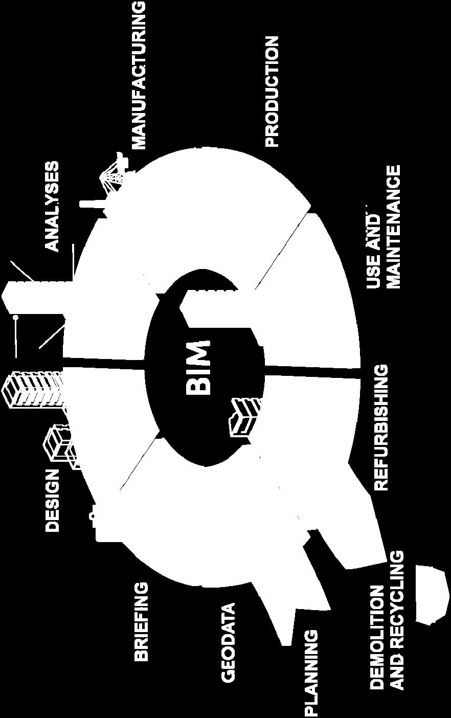
17 Integrated information flow - requires knowledge and mutual understanding of the respective roles in the lifecycle BIM Geodata 17
18 Our challenges! We work with 3D city models for planning, presentation and visualization We have developed routines specific to different municipalities and system vendors for surveying archiving and delivery (even if we partly use existing standards like City-GML and others We spend a lot of time transforming and adjusting data that we receive from and deliver to external parties Data are often not used by other parties due to lacking standards compliance BIM- models can not be used and reused by the municipalities in their processes
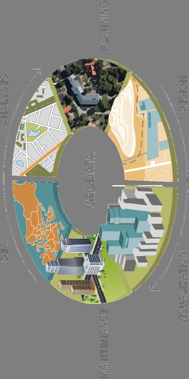
19 We must explore at the interfaces Geodata BIM
20 We miss! Recommendations and standards for 3D geodata Gathering and surveying Storing and archiving Access and delivery Knowledge about the integrated use of BIM models A common process for all actors involved for the entire workflow from conceptual idea to maintenance and use


21 21

22


23 External models Optimizing to a building shell manual labour Högdetaljering, original Polys: D-team Stadsmätning 3dvisualisering@stockholm.se Lågdetaljering, manuell modellering Polys: Arbetstid 4h 23


24 Current process Regional plan 2D Concept planning 3D Town planning 2D Property registration 2D/3D Design 3D Building permit 2D Construction 3D Maintenance 2D 24
25 What will the project do? formulate guidelines for coordinated information models with GIS and BIM geometry and attributes, based on Svensk Geoprocess and CoClass. describe desired content and exchange format for prioritized interfaces illustrate judicial/regulatory obstacles and propose solutions chart the demands on storage and sustainable access verify the applicability of the proposed measures by testing in realistic cases disseminate the results of the activities and promote their further application Elisabeth Argus BonaCordi AB 25

26 An uninterrupted flow of geodata - requires that the threshold are overcome, using standards and specifiations, plus dialogue 26


27 How is the project organized? Five working groups based regionally. 3-4 months is scheduled for each group Before handover to the next working group tests and verfication is performed, to be taken into account for the next phase Working group leaders and the project support team are responsible for communication and coordination between the working groups Umeå and environs 5. Storage and sustainable access Falun and environs 4. BIM and building permits Stockholm and environs 3. BIM and property registration Gothenburg and environs 1. Product package Malmö and environs 2. 3D town planning Elisabeth Argus BonaCordi AB 27


28 Smart Built Environment Intern organisation Approx. 40 Partners, and growing Annual meeting Board Office Programme director, programme manager, communications Advisory group External assessment group(s) Strategic project pkg 1 Process manager Strategic project pkg 2 Process manager Open call 1 Process manager


29 Our activities Project portfolio Allocation RDI 25% 25% 50% 50% 50% Strategic projects Open calls Research Development Innovation
30 Strategic base for the programme Business driven applications Integration of processes Information infrastructure Innovation and new applications Business models Knowledge boost Innovation lab Research platform Legal and organisation Lifecycle perspective Standardization
31 Bli part i programmet Påverka programmets inriktning, strategiska projekt och utlysningar Medverka i styrelse eller välj in representanter Ta plats i partsnätverket och medverka i programmets aktiviteter Stöd programmet genom eget arbete eller kontant finansiering Nyttja programmets resultat och skapa förändring Det är avgiftsfritt att bli part!


32 Parter i programmet

33 Smart Built Environment
The Swedish National Geodata Strategy and the Geodata Project
 The Swedish National Geodata Strategy and the Geodata Project Ewa Rannestig, Head of NSDI Co-ordination Unit, Lantmäteriet, ewa.rannstig@lm.se Ulf Sandgren, Project Manager Geodata Project, Lantmäteriet,
SWEDISH SDI DEVELOPMENT & IMPLEMENTATION OF INSPIRE
 SWEDISH SDI DEVELOPMENT & IMPLEMENTATION OF INSPIRE Christina Wasström, Lantmäteriet, 801 82 Gävle, Sweden, christina.wasstrom@lm.se ABSTRACT The Swedish Government and Parliament has given Lantmäteriet
INSPIRE in Sweden - an Important Part of the National Geodata Strategy
 INSPIRE in Sweden - an Important Part of the National Geodata Strategy Ewa RANNESTIG and Monica LAGERQVIST NILSSON, Sweden Key words: National Geodata Strategy, National Infrastructure for Spatial Information,
Land Use in the context of sustainable, smart and inclusive growth
 Land Use in the context of sustainable, smart and inclusive growth François Salgé Ministry of sustainable development France facilitator EUROGI vice president AFIGéO board member 1 Introduction e-content+
Swedish Spatial Data Infrastructure and the National Geodata Strategy
 Submitted to the United Nations Committee of Experts on Global Geospatial Information Management Seventh Session New York, August 2018 Registration number 519-2018/4327 Country Report, Sweden Swedish Spatial
Maanmittauspäivät 2018 Helsinki Maanmittauspäivät 2018 The Danish initiatives regarding open and free basic data including effect studies
 Maanmittauspäivät 2018 The Danish initiatives regarding open and free basic data including effect studies 22.03.2018 Agenda 1. Intro overall frame / selfie 2. Data Infrastructure 3. The Danish Digital
Oman NSDI Business Values and Future Directions. Hassan Alawi Alghazali Acting Director General National Spatial Data Infrastructure
 Oman NSDI Business Values and Future Directions Hassan Alawi Alghazali Acting Director General National Spatial Data Infrastructure Presentation Outline Geospatial Maturity Current Challenges NCSI s Role
GIS Geographical Information Systems. GIS Management
 GIS Geographical Information Systems GIS Management Difficulties on establishing a GIS Funding GIS Determining Project Standards Data Gathering Map Development Recruiting GIS Professionals Educating Staff
National Geodata Strategy for Sweden Developed co-operation for Open and Usable Geodata Via Services
 National Geodata Strategy for Sweden 2016-2020 - Developed co-operation for Open and Usable Geodata Via Services Peter NYHLÉN, Sweden Key words: SDI, Geodata, Strategy, Open, Cooperation SUMMARY In consultation
A proposal for building an infrastructure for European geospatial statistics. Marie Haldorson, Statistics Sweden Ekkehard Petri, Eurostat
 A proposal for building an infrastructure for European geospatial statistics Marie Haldorson, Statistics Sweden Ekkehard Petri, Eurostat What is geospatial statistics? The location, extent or spatial relations
A proposal for building an infrastructure for European geospatial statistics
 A proposal for building an infrastructure for European geospatial statistics Marie Haldorson, Statistics Sweden Ekkehard Petri, Eurostat What is geospatial statistics? The location, extent or spatial relations
Exploit your geodata to enable smart cities and countries
 Exploit your geodata to enable smart cities and countries Carsten Rönsdorf, Head of Advisory Services Middle East Practice Manager Future Cities, standards and 3D 24 November 2014 Importance of Standards
GEOVEKST A Norwegian Program for Cost Sharing in Production, Updating and Administration of Geographic Data
 GEOVEKST A Norwegian Program for Cost Sharing in Production, Updating and Administration of Dr. Anne Kirsten S. HØSTMARK, Norway Key words: Mapping in large scale, formal co-operation, cost sharing, standarised
Swedish Spatial Data Infrastructure and the National Geodata Strategy
 Submitted to United Nations Committee of Experts on Global Geospatial Information Management Seventh Session New York, August 2017 Country Report of Sweden Swedish Spatial Data Infrastructure and the National
The National Policy Strategy for Infrastructure and Spatial Planning CODE24 CONFERENCE. Emiel Reiding
 The National Policy Strategy for Infrastructure and Spatial Planning Emiel Reiding Structure of presentation 1. Spatial planning in the Netherlands 2. National Policy Strategy Aims National interests 3.
GIS Building Communities beyond National Borders (Building Successful Spatial Data Infrastructures) Nick Land, ESRI Europe
 Nick Land, ESRI Europe") GIS Building Communities beyond National Borders (Building Successful Spatial Data Infrastructures) Nick Land, ESRI Europe UK worst flooding in the last 60 years 350,000 households without drinking water
GIS Building Communities beyond National Borders (Building Successful Spatial Data Infrastructures) Nick Land, ESRI Europe UK worst flooding in the last 60 years 350,000 households without drinking water
Appropriation Directions for 2007
 INSPIRE in Sweden An Important Part of the National Geodata Strategy Monica Lagerqvist Nilsson Appropriation Directions for 2007 A commission to investigate the necessity to adjust the Swedish legislation
The purpose of this report is to recommend a Geographic Information System (GIS) Strategy for the Town of Richmond Hill.
 Strategy for the Town of Richmond Hill.") Staff Report for Committee of the Whole Meeting Department: Division: Subject: Office of the Chief Administrative Officer Strategic Initiatives SRCAO.18.12 GIS Strategy Purpose: The purpose of this report
Staff Report for Committee of the Whole Meeting Department: Division: Subject: Office of the Chief Administrative Officer Strategic Initiatives SRCAO.18.12 GIS Strategy Purpose: The purpose of this report
Geodata flow TUKES GTK mineral exploration data - future prospecting capital!
 Geodata flow TUKES GTK mineral exploration data - future prospecting capital! Head of Unit, Regional Geodata and Interpretation Jouni Vuollo, GTK, 2016 Final report Six months Mineral exploration data
FIRE DEPARMENT SANTA CLARA COUNTY
 DEFINITION FIRE DEPARMENT SANTA CLARA COUNTY GEOGRAPHIC INFORMATION SYSTEM (GIS) ANALYST Under the direction of the Information Technology Officer, the GIS Analyst provides geo-spatial strategic planning,
RURAL-URBAN PARTNERSHIPS: AN INTEGRATED APPROACH TO ECONOMIC DEVELOPMENT
 RURAL-URBAN PARTNERSHIPS: AN INTEGRATED APPROACH TO ECONOMIC DEVELOPMENT William Tompson Head of the Urban Development Programme OECD Public Governance and Territorial Development Directorate JAHRESTAGUNG
Status of implementation of the INSPIRE Directive 2016 Country Fiches. COUNTRY FICHE Finland
 Status of implementation of the INSPIRE Directive 2016 Country Fiches COUNTRY FICHE Finland Introduction... 1 1. State of Play... 2 1.1 Coordination... 2 1.2 Functioning and coordination of the infrastructure...
The view of Europaforum Northern Sweden concerning the future of EU cohesion policy
 Northern Sweden 2008-01-31 The view of Europaforum Northern Sweden concerning the future of EU cohesion policy Europaforum Northern Sweden Europaforum Northern Sweden is a partnership and network for councillors
Economic Benefit Study on Value of Spatial Information Australian Experience
 Economic Benefit Study on Value of Spatial Information Australian Experience Dr Zaffar Sadiq Mohamed-Ghouse Director, International Relations Cooperative Research Centre for Spatial Information zsadiq@crcsi.com.au
Earth Observation and GEOSS in Horizon Copernicus for Raw Material Workshop 5 th September 2016
 Earth Observation and GEOSS in Horizon 2020 Copernicus for Raw Material Workshop 5 th September 2016 Gilles OLLIER Head of Sector -Earth observation Directorate Environment Unit I.4 Climate Actions and
EXPECTATIONS OF TURKISH ENVIRONMENTAL SECTOR FROM INSPIRE
 EXPECTATIONS OF TURKISH ENVIRONMENTAL SECTOR FROM INSPIRE June, 2010 Ahmet ÇİVİ Tuncay DEMİR INSPIRE in the Eyes of MoEF Handling of Geodata by MoEF Benefits Expected TEIEN First Steps for INSPIRE Final
Open spatial data infrastructure
 Open spatial data infrastructure a backbone for digital government Thorben Hansen Geomatikkdagene 2018 Stavanger 13.-15. mars Spatial Data Infrastructure definition the technology, policies, standards,
PART A Project summary
 PART A Project summary A.1 Project identification Project title Project acronym Name of the lead partner organisation in English Specific objective Demonstrattion AF DAF Partner 1.1. Improving innovation
Testing of Geoportals: INSPIRE demands and challenges
 Testing of Geoportals: INSPIRE demands and challenges Imad Abugessaisa & Solgerd Tanzilli Lantmäteriet - Swedish Mapping, Cadastre and Land Registration Authority / Future Position X, Gävle INSPIRE 2010
About peer review missions related to data management
 PEER REVIEW WORKSHOP ABOUT DATA MANAGEMENT Introduction Paul HAENER International Office for Water FRANCE p.haener@oieau.fr October 2016 About peer review missions related to data management 2 1 Data management
Arctic Spatial Data Infrastructure Enabling Access to Arctic Location-Based Information
 Arctic Spatial Data Infrastructure Enabling Access to Arctic Location-Based Information Arctic SDI Side Event Co-Chairs: Arvo Kokkonen Arctic SDI Board Chair & Director General, National Land Survey of
Jordan's Strategic Research Agenda in cultural heritage
 Jordan's Strategic Research Agenda in cultural heritage Analysis of main results Alessandra Gandini Amman, Jordan 3 rd November 2013 Main objectives The work performed had the main objective of giving
Landreport Sweden
 L A N T M Ä T E R I E T 1 (7) 2016-05-25 v 1.0 Landreport Sweden 2015-2016 1. The Address register current situation The number of addresses is about 3.7 million. The updating runs for good, but there
THE ROLE OF REGIONAL SPATIAL PLANNING IN SUPPORTING LONG-TERM ECONOMIC GROWTH IN NORTHERN IRELAND
 THE ROLE OF REGIONAL SPATIAL PLANNING IN SUPPORTING LONG-TERM ECONOMIC GROWTH IN NORTHERN IRELAND Jenny Pyper Director 6 th Annual ICLRD Conference 20 January 2011 PURPOSE OF REGIONAL PLANNING Framework
Functional territories in a eastern Norway and western Sweden perspective Armagh 16. November
 Functional territories in a eastern Norway and western Sweden perspective Armagh 16. November Dr. Bjørnar Sæther Professor in Human Geography Eastern Norway Research Institute (ENRI) University of Oslo
EuroSDR (European Spatial Data Research)
") EuroSDR (European Spatial Data Research) ROLLING RESEARCH PLAN 2015-2018 EuroSDR Secretariat Public Governance Institute KU Leuven Parkstraat 45 bus 3609 3000 Leuven Belgium Tel.: +32 16 32 31 80 Fax:
EuroSDR (European Spatial Data Research) ROLLING RESEARCH PLAN 2015-2018 EuroSDR Secretariat Public Governance Institute KU Leuven Parkstraat 45 bus 3609 3000 Leuven Belgium Tel.: +32 16 32 31 80 Fax:
St. Pölten University of Applied Sciences. Strategy St. Pölten University of Applied Sciences. fhstp.ac.at
 St. Pölten University of Applied Sciences Strategy 2021 St. Pölten University of Applied Sciences fhstp.ac.at St. Pölten UAS: My best place Our vision St. Pölten University of Applied Sciences (St. Pölten
Status of implementation of the INSPIRE Directive 2016 Country Fiches. COUNTRY FICHE Netherlands
 Status of implementation of the INSPIRE Directive 2016 Country Fiches COUNTRY FICHE Netherlands Introduction... 1 1. State of Play... 2 1.1 Coordination... 2 1.2 Functioning and coordination of the infrastructure...
Ministry of Health and Long-Term Care Geographic Information System (GIS) Strategy An Overview of the Strategy Implementation Plan November 2009
 Strategy An Overview of the Strategy Implementation Plan November 2009") Ministry of Health and Long-Term Care Geographic Information System (GIS) Strategy An Overview of the Strategy Implementation Plan November 2009 John Hill, Health Analytics Branch Health System Information
Ministry of Health and Long-Term Care Geographic Information System (GIS) Strategy An Overview of the Strategy Implementation Plan November 2009 John Hill, Health Analytics Branch Health System Information
Multinational Spatial Planning Experience
 POLAND Multinational Spatial Planning Experience of the Baltic Sea Region Competitiveness and territorial cohesion in Eastern and South-Eastern Europe Magdalena Zagrzejewska-Fiedorowicz VASAB 2010 Visions
CHARTING SPATIAL BUSINESS TRANSFORMATION
 CHARTING SPATIAL BUSINESS TRANSFORMATION An in-depth look at the business patterns of GIS and location intelligence adoption in the private sector EXECUTIVE SUMMARY The global use of geographic information
Spatial Data Availability Energizes Florida s Citizens
 NASCIO 2016 Recognition Awards Nomination Spatial Data Availability Energizes Florida s Citizens State of Florida Agency for State Technology & Department of Environmental Protection Category: ICT Innovations
Implementation of the ESPON 2020 cooperation program. 16 January 2017 Anneloes van Noordt
 Implementation of the ESPON 2020 cooperation program 16 January 2017 Anneloes van Noordt Outline! ESPON Cooperation Program! Specific Objectives! Applied Research! Targeted Analysis! Database & Tools!
Challenges and Successes in Sharing Geospatial Data in Africa
 Challenges and Successes in Sharing Geospatial Data in Africa 2018 GeoNode Summit Torino, Italy March 26-28, 2018 Bernard Justus Muhwezi Manager, Geo-Information Services Uganda Bureau of Statistics, Kampala,
2 nd Semester. Core Courses. C 2.1 City and Metropolitan Planning. Module 1: Urban Structure and Growth Implications
 2 nd Semester Core Courses C 2.1 City and Metropolitan Planning Module 1: Urban Structure and Growth Implications Growth of cities; cities as engine of growth; urban sprawl; land value, economic attributes
Section 2. Indiana Geographic Information Council: Strategic Plan
 Section 2. Indiana Geographic Information Council: Strategic Plan Introduction A geographic information system (GIS) is an automated tool that allows the collection, modification, storage, analysis, and
E-Government and SDI in Bavaria, Germany
 135 E-Government and SDI in Bavaria, Germany Wolfgang STOESSEL, Germany Key words: GDI-BY, Bavaria, Spatial Data Infrastructure SUMMARY Spatial Data Infrastructure (SDI) is an important part of the e-government
Collaboration, Automation & Foundation Data: three steps towards spatially enabled government **
 ADVANCE UNEDITED VERSION UNITED NATIONS E/CONF.103/25 ECONOMIC AND SOCIAL COUNCIL Tenth United Nations Regional Cartographic Conference for the Americas New York, 19-23, August 2013 Item 6 (a) of the provisional
TRAITS to put you on the map
 TRAITS to put you on the map Know what s where See the big picture Connect the dots Get it right Use where to say WOW Look around Spread the word Make it yours Finding your way Location is associated with
Observation (EO) & Geomatics in Canada
 & Geomatics in Canada") Innovating to Increase the Impact of Earth Observation (EO) & Geomatics in Canada Natural Resources Canada February 25, 2014 Prashant Shukle, Director General Canada Centre for Mapping and Earth Observation
Innovating to Increase the Impact of Earth Observation (EO) & Geomatics in Canada Natural Resources Canada February 25, 2014 Prashant Shukle, Director General Canada Centre for Mapping and Earth Observation
Urban Climate Resilience
 Urban Climate Resilience in Southeast Asia Partnership Project Introduction Planning for climate change is a daunting challenge for governments in the Mekong Region. Limited capacity at the municipal level,
Entrepreneurship on islands and other peripheral regions. Specific Contract No 6511 implementing Framework contract No CDR/DE/16/2015/
 Entrepreneurship on islands and other peripheral regions Specific Contract No 6511 implementing Framework contract No CDR/DE/16/2015/ Aims of this study: To analyse the particular challenges and obstacles
CHAPTER 22 GEOGRAPHIC INFORMATION SYSTEMS
 CHAPTER 22 GEOGRAPHIC INFORMATION SYSTEMS PURPOSE: This chapter establishes the administration and use of to improve the quality and accessibility of Department s spatial information and support graphical
1. Omit Human and Physical Geography electives (6 credits) 2. Add GEOG 677:Internet GIS (3 credits) 3. Add 3 credits to GEOG 797: Final Project
 2. Add GEOG 677:Internet GIS (3 credits) 3. Add 3 credits to GEOG 797: Final Project") The Department of Geography and the Office of Professional Studies propose to modify the Master of Professional Studies in Geospatial Information Sciences (GIS) as follows: 1. Omit Human and Physical Geography
The Department of Geography and the Office of Professional Studies propose to modify the Master of Professional Studies in Geospatial Information Sciences (GIS) as follows: 1. Omit Human and Physical Geography
Governance and performance of open spatial data policies in the context of INSPIRE
 Governance and performance of open spatial data policies in the context of INSPIRE Dr. Glenn Vancauwenberghe Delft University of Technology Dr. ir. Bastiaan van Loenen Delft University of Technology 1
Geological information for Europe : Towards a pan-european Geological Data Infrastructure
 Geological information for Europe : Towards a pan-european Geological Data Infrastructure Integrating geoscientific information for EU competitiveness Co-funded by the European Union European societal
KUNMING FORUM ON UNITED NATIONS GLOBAL GEOSPATIAL INFORMATION MANAGEMENT CITIES OF THE FUTURE: SMART, RESILIENT
 KUNMING FORUM ON UNITED NATIONS GLOBAL GEOSPATIAL INFORMATION MANAGEMENT CITIES OF THE FUTURE: SMART, RESILIENT and SUSTAINABLE Yunnan Zhenzhuang Guest House, Kunming, China 10 12 May 2017 BACKGROUND CONCEPT
Vienna urban development - seestadt aspern as urban future lab
 Vienna urban development - seestadt aspern as urban future lab PERMACULTURE DESIGN COURSE * 2012 * ASPERN SEESTADT 1 Christof Schremmer, ÖIR Austrian Institute for Regional Studies and Spatial Planning
Status of implementation of the INSPIRE Directive 2016 Country Fiches. COUNTRY FICHE Malta
 Status of implementation of the INSPIRE Directive 2016 Country Fiches COUNTRY FICHE Malta Introduction... 1 1. State of Play... 2 1.1 Coordination... 2 1.2 Functioning and coordination of the infrastructure...
BIM and INSPIRE, for a better integration of built infrastructures in their environment : the MINnD project
 BIM and INSPIRE, for a better integration of built infrastructures in their environment : the MINnD project François ROBIDA Christophe CASTAING Strasbourg, > 1 8 septembre 2017 ABOUT BIM Building Information
SPURRING NATION S ECONOMY THROUGH SmartKADASTER
 SPURRING NATION S ECONOMY THROUGH SmartKADASTER SR MOHAMAD KAMALI BIN ADIMIN DIVISION DIRECTOR (CADASTRE) DEPARTMENT OF SURVEY AND MAPPING MALAYSIA THE NEED TO TRANSFORM TRANSFORMATION AGENDA EMPOWERING
Development of a Dainish infrastructure for spatial information (DAISI) Brande-Lavridsen, Hanne; Jensen, Bent Hulegaard
 Brande-Lavridsen, Hanne; Jensen, Bent Hulegaard") Aalborg Universitet Development of a Dainish infrastructure for spatial information (DAISI) Brande-Lavridsen, Hanne; Jensen, Bent Hulegaard Published in: NORDGI : Nordic Geographic Information Publication
Aalborg Universitet Development of a Dainish infrastructure for spatial information (DAISI) Brande-Lavridsen, Hanne; Jensen, Bent Hulegaard Published in: NORDGI : Nordic Geographic Information Publication
Discovering The World Of Chemistry
 Discovering The World Of Chemistry Dr. Dimitrios Tzalis IMI Open Info Day: Horizon 2020 - Health, demographic change and wellbeing 18th September 2015 Brussel Taros Chemicals GmbH & Co. KG Taros: Stability,
Briefing. H.E. Mr. Gyan Chandra Acharya
 Briefing by H.E. Mr. Gyan Chandra Acharya Under-Secretary-General and High Representative for the Least Developed Countries, Landlocked Developing Countries and Small Island Developing States Briefing
DRAFT PROGRAM Registration of participants, welcome coffee, exhibition tour
 DRAFT PROGRAM 20 Feb 2018 09.00-10.00 Registration of participants, welcome coffee, exhibition tour 10.00 12.00 ROUND TABLE: INTERNATIONAL COOPERATION IN THE ARCTIC PROJECTS: CHALLENGES AND OPPORTUNITIES
a national geological survey perspective François ROBIDA BRGM (French Geological Survey)
") a national geological survey perspective François ROBIDA BRGM (French Geological Survey) Pre-Conference Seminar on Socio-Economic Value of Geospatial for National and Regional Development 21 August 2017,
a national geological survey perspective François ROBIDA BRGM (French Geological Survey) Pre-Conference Seminar on Socio-Economic Value of Geospatial for National and Regional Development 21 August 2017,
GOVERNMENT MAPPING WORKSHOP RECOVER Edmonton s Urban Wellness Plan Mapping Workshop December 4, 2017
 GOVERNMENT MAPPING WORKSHOP 12.4.17 RECOVER Edmonton s Urban Wellness Plan Mapping Workshop December 4, 2017 In July of 2017, City Council directed administration to develop RECOVER, Edmonton s Urban Wellness
Declaration Population and culture
 Declaration Population and culture The ministers of the parties to the Alpine Convention regard the socio-economic and socio-cultural aspects mentioned in Article 2, Paragraph 2, Item a., as being central
COUNCIL OF THE EUROPEAN UNION. Brussels, 2 May /14 CULT 68
 COUNCIL OF THE EUROPEAN UNION Brussels, 2 May 2014 9129/14 CULT 68 NOTE from: General Secretariat of the Council to: Permanent Representatives Committee (Part 1) / Council No. prev. doc.: 8892/14 CULT
Using OGC standards to improve the common
 Using OGC standards to improve the common operational picture Abstract A "Common Operational Picture", or a, is a single identical display of relevant operational information shared by many users. The
Transportation and Logistics Planning and Development Mapping Tool
 Transportation and Logistics Planning and Development Mapping Tool Doreen Gonzales-Gaboyan Business Development and Outreach Center for Innovation through Visualization and Simulation (CIVS) Purdue University
The Importance of Geospatial in the Construction Industry. 10 December, 2015
 The Importance of Geospatial in the Construction Industry 10 December, 2015 Transformation will drive Build Operate Reduce Total Cost of Use Increased design freedom to deliver better infrastructure Reduce
MEMORANDUM OF UNDERSTANDING FOR THE ESTABLISHMENT OF A CARPATHIAN INTEGRATED BIODIVERSITY INFORMATION SYSTEM
 MEMORUM OF UNDERSTING FOR THE ESTABLISHMENT OF A CARPATHIAN INTEGRATED BIODIVERSITY INFORMATION SYSTEM BETWEEN DAPHNE - INSTITUTE OF APPLIED ECOLOGY (hereinafter referred to DAPHNE) EUROPEAN ACADEMY BOLZANO
SMART CITIES NEED LOCATION DATA
 SMART CITIES NEED LOCATION DATA Carsten Rönsdorf 27 May 2015 Lisbon Future Cities need Location Data Geospatial World Forum 27 May 2015 Carsten Rönsdorf, Head of Advisory Services, OS International OFFICIAL
Technical Specifications. Form of the standard
 Used by popular acceptance Voluntary Implementation Mandatory Legally enforced Technical Specifications Conventions Guidelines Form of the standard Restrictive Information System Structures Contents Values
AMS E-GOS Local governance and performance of open data policies at municipal level
 AMS E-GOS Local governance and performance of open data policies at municipal level Frederika Welle Donker Knowledge Centre Open Data TU Delft f.m.welledonker@tudelft.nl 1 Knowledge Centre Open Data Research
Sistema de Informacion Geografica Peninsular de Yucatan (SIGPY): WORK PLAN for the UQROO- URI GIS Development Project
: WORK PLAN for the UQROO- URI GIS Development Project") Sistema de Informacion Geografica Peninsular de Yucatan (SIGPY): WORK PLAN for the UQROO- URI GIS Development Project Eddie Ellis, UQROO 2001 Citation: Quintana Roo, Mexico: Universidad de Quintana Roo
Sistema de Informacion Geografica Peninsular de Yucatan (SIGPY): WORK PLAN for the UQROO- URI GIS Development Project Eddie Ellis, UQROO 2001 Citation: Quintana Roo, Mexico: Universidad de Quintana Roo
ESPON support for Targeted Analyses Ilona Raugze Director
 ESPON support for Targeted Analyses Ilona Raugze Director ESPON EGTC 14 November 2017 ESPON EGTC workshop Targeted Analysis in support of better policy making in cities and regions Inspire policy making
SPATIAL STRATEGIES ON THE ISLAND OF IRELAND: FRAMEWORK FOR COLLABORATION
 SPATIAL STRATEGIES ON THE ISLAND OF IRELAND: FRAMEWORK FOR COLLABORATION THE PRACTICAL OPPORTUNITIES Mr. John Driscoll, Director, International Centre for Local and Regional Development Mr. Jim Hetherington,
INSPIRE in Sweden.
 INSPIRE in Sweden Swedish National Data Service Established 2008. SND is a service organisation for Swedish research within the Humanities, Social Sciences and Medicine. SND is the Swedish node in an international
ISO Series Standards in a Model Driven Architecture for Landmanagement. Jürgen Ebbinghaus, AED-SICAD
 ISO 19100 Series Standards in a Model Driven Architecture for Landmanagement Jürgen Ebbinghaus, AED-SICAD 29.10.2003 The Company 100% SIEMENS PTD SIEMENS Business Services Shareholder & Strategic Business
The Canadian Ceoscience Knowledge Network. - A Collaborative Effort for Unified Access to Ceoscience Data
 The Canadian Ceoscience Knowledge Network - A Collaborative Effort for Unified Access to Ceoscience Data The Canadian Geoscience Knowledge Network A Collaborative Effort for Unified Access to Geoscience
The greatest GIS-fusion in the history of Denmark
 The greatest GIS-fusion in the history of Denmark The structural reform of the Danish public sector Anita Enevoldsen, Municipality of Vejen Per M. Jørgensen, J Municipality of Vejle Merete Hansen, Municipality
Population. Date established: 29 October EGTC: Established on 25 August 2009 The Euroregion s legal and administrative arm
 KEY DATES AND FIGURES Date established: 29 October 2004 Surface area: 109 830 km 2 Member territories: Catalonia, Balearic Islands, Languedoc-Roussillon and Midi-Pyrénées EGTC: Established on 25 August
Low Density Areas : Places of Opportunity. Enrique Garcilazo, OECD Directorate for Public Governance and Territorial Development
 Low Density Areas : Places of Opportunity Enrique Garcilazo, OECD Directorate for Public Governance and Territorial Development Open Days, Brussels, 11 th October, 2016 Outline 1. Performance low density
Study Visit University of Applied Sciences Utrecht Netherlands
 Study Visit University of Applied Sciences Utrecht Netherlands Directorate-General for Territorial Development Lisbon 1 April 2014 1 Agenda Presentation Cadastre Department Surveying / Geodesy Department
Esri and GIS Education
 Esri and GIS Education Organizations Esri Users 1,200 National Government Agencies 11,500 States & Regional Agencies 30,800 Cities & Local Governments 32,000 Businesses 8,500 Utilities 12,600 NGOs 11,000
Spatial Planning and Territorial Development at the Regional Level
 Spatial Planning and Territorial Development at the Regional Level Vincent Nadin University of the West of England, UK Spatial Planning and Territorial Development at the Regional Level Vincent Nadin University
INSPIRing effort. Peter Parslow Ordnance Survey December Various European approaches to managing an SDI
 INSPIRing effort Peter Parslow Ordnance Survey December 2015 Various European approaches to managing an SDI WHAT IS INSPIRE? A European Union Directive A community effort: http://inspire.ec.europa.eu/
Economic and Social Council
 United Nations Economic and Social Council Distr.: General 2 July 2012 E/C.20/2012/10/Add.1 Original: English Committee of Experts on Global Geospatial Information Management Second session New York, 13-15
Global Geospatial Information Management Country Report Finland. Submitted by Director General Jarmo Ratia, National Land Survey
 Global Geospatial Information Management Country Report Finland Submitted by Director General Jarmo Ratia, National Land Survey Global Geospatial Information Management Country Report Finland Background
Status of implementation of the INSPIRE Directive 2016 Country Fiches. COUNTRY FICHE Denmark
 Status of implementation of the INSPIRE Directive 2016 Country Fiches COUNTRY FICHE Denmark Introduction... 1 1. State of Play... 2 1.1 Coordination... 2 1.2 Functioning and coordination of the infrastructure...
Investigating the practical relationship between GIS and BIM; then relating that to a 3D cadastre. J. Gabriel van Wyk, Johan Nel
 Investigating the practical relationship between GIS and BIM; then relating that to a 3D cadastre. J. Gabriel van Wyk, Johan Nel Overview So exactly what is BIM? Available BIM offerings in the market Traditional
Collaborative Geotechnical BIM technologies. Carl Grice Software Development Director (Keynetix) Holger Kessler - Team Leader Modelling Systems (BGS)
 Holger Kessler - Team Leader Modelling Systems (BGS)") Collaborative Geotechnical BIM technologies Carl Grice Software Development Director (Keynetix) Holger Kessler - Team Leader Modelling Systems (BGS) 1 2 3 Current Challenges R&D Project Proposed Solution
Collaborative Geotechnical BIM technologies Carl Grice Software Development Director (Keynetix) Holger Kessler - Team Leader Modelling Systems (BGS) 1 2 3 Current Challenges R&D Project Proposed Solution
Impact Policies Enabling Value Enhancement of Geospatial Information in Canadian Economy and Society
 1 Impact Policies Enabling Value Enhancement of Geospatial Information in Canadian Economy and Society May 26, 2015 Prashant Shukle, Director General Canada Centre for Mapping and Earth Observation Increased
Country Report On Sdi Activities In Singapore ( )
") UNITED NATIONS E/CONF.102/IP.4 ECONOMIC AND SOCIAL COUNCIL Nineteenth United Nations Regional Cartographic Conference for Asia and the Pacific Bangkok, 29 October 1 November 2012 Item 6(b) of the provisional
UNITED NATIONS E/CONF.102/IP.4 ECONOMIC AND SOCIAL COUNCIL Nineteenth United Nations Regional Cartographic Conference for Asia and the Pacific Bangkok, 29 October 1 November 2012 Item 6(b) of the provisional
CONFERENCE STATEMENT
 CONFERENCE STATEMENT We, the elected representatives from Canada, Denmark/Greenland, Finland, Iceland, Norway, Russia, Sweden and the United States of America; In collaboration with the indigenous peoples
ASSESSMENT. Industry Solutions Harness the Power of GIS for Property Assessment
 ASSESSMENT Industry Solutions Harness the Power of GIS for Property Assessment Esri Canada has thousands of customers worldwide who are using the transforming power of GIS technology to collect, maintain,
Oregon Department of Transportation. Geographic Information Systems Strategic Plan
 Oregon Department of Transportation Geographic Information Systems Strategic Plan Adopted May, 2000 By the GIS Steering Committee Last printed 10/2/2012 4:20:00 PM Page Geographic Information Systems Strategic
Green Chemistry Member Survey April 2014
 Green Chemistry Member Survey April 2014 www.greenchemistryandcommerce.org Summary In 2014, the Green Chemistry & Commerce Council surveyed its business members to gain a better understanding of their