Harvesting in the Arab Region (
|
|
|
- Katrina Miller
- 5 years ago
- Views:
Transcription


1 Title Shallow Water Flow Based Simulation Small Catchments Author(s) Tügel, Franziska; Özgen, Özgen; Had Uwe; Hinkelmann, Reinhard Proceedings of the Second Internati Citation Floods in Wadi Systems: Disaster Ri Harvesting in the Arab Region (216 Issue Date URL Right Type Presentation Textversion author Kyoto University
2 Shallow Water Flow Based Simulation of Flash Floods in Small Catchments Franziska Tügel 1,*, Ilhan Özgen 1, Ahmed Hadidi 2, Uwe Tröger 3, Reinhard Hinkelmann 1 1, 2 Chair for Hydrogeology,, 3 TU-Berlin, Zentralinstitut El Gouna, Fraunhoferstr , 1587 Berlin * Corresponding author franziska.tuegel@wahyd.tu-berlin.de Keywords: Shallow Water Equations, Urban Flooding, Natural Catchments, Infiltration Flash floods as a result of heavy rainfalls often cause severe damages to settlements and the environment. In future, the occurrence and intensity of heavy rainfalls might increase due to climate change. The simulation of flash floods is an important tool to analyze flow processes during and after rainfall events and to develop methods to protect settlements and the environment against damages caused by flooding. Generally, rainfall-runoff simulation in catchments is carried out with hydrological models which only roughly can take into account the topography, flooding areas and local details of flow processes. To overcome these drawbacks, shallow water based models have been further developed and applied in recent years. The Hydroinformatics Modelling System (HMS) can be used for different applications, as for example rainfall-runoff and flood modelling. HMS is a Java-based framework which is developed at the,. The two dimensional depth averaged shallow water equations are discretized with a cell centered finite volume method and solved with an explicit MUSCL scheme. Precipitation and infiltration are considered as source/sink terms in the mass balance equation. Different applications of HMS will be presented: (1) the simulation of a dam-break through an idealized city (flooding), (2) rainfall-runoff simulation in a natural catchment and (3) rainfall-runoff simulation considering infiltration with the Green-Ampt model. One future objective is to set up a model of the El Gouna region in HMS. Preliminary studies contain the analysis of different scenarios concerning bottom friction, slope, rainfall, infiltration and additional inflow from upstream for an idealized catchment. By implementing a digital elevation model (DEM) the topography of the natural catchment will be taken into account to simulate the runoff in the region of El Gouna. During the flash flood event on 9 March 214 data of rainfall and runoff were measured and are published in the doctoral thesis of Hadidi (216). This event will be simulated with HMS and the numerical results will be compared with the measured data. Later on the model will be applied to investigate different scenarios of structural measures to protect the city of El Gouna against flooding. 34


3 Shallow water flow based simulation of flash floods in small catchments F. Tügel, I. Özgen, A. Hadidi, U. Tröger, R. Hinkelmann,, TU-Berlin, Zentralinstitut El Gouna Shallow water flow based simulation of flash floods in small catchments Slide 1 Shallow water flow based simulation of flash floods in small catchments Slide 2 Hydrological, hydraulic and environmental problems flooded urban and rural areas interactions feedback effects sediment transport / morphology contaminant transport infiltration urban runoff Shallow water flow based simulation of flash floods in small catchments Slide 3 Shallow water flow based simulation of flash floods in small catchments Slide 4 Numerical modeling of hydro- and environmental systems Flash floods processes Simulation of flash floods to: analyze structural protection measures develop early warning systems classical & new application fields high performance computing standard & robust numerical methods high resolution data 2D shallow water models: consider complex topographies, flooding areas and local flow processes support high-resolution grids (~1m) to better resolve urban structures include robust numerical methods which enable the modelling of propagating wet-dry fronts deliver results of flow evolution in the whole simulated domain including water depths and flow velocities Shallow water flow based simulation of flash floods in small catchments Slide 5 Shallow water flow based simulation of flash floods in small catchments Slide 6


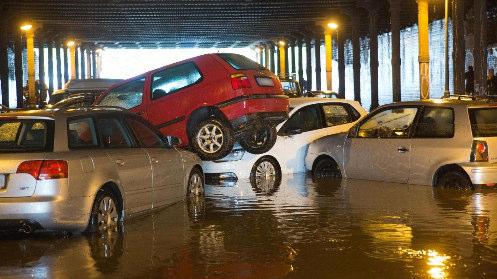

4 Flash floods El Gouna, 9 th March 214 product of extreme weather conditions cause severe damages flooded city of El Gouna storage and usage of fresh water need of mitigation measures Shallow water flow based simulation of flash floods in small catchments Slide 7 Shallow water flow based simulation of flash floods in small catchments Slide 8 Hurghada 9 th March 214 Berlin, 27 th July 216 parking cars transported by flood Hurghada airport flooded city of Berlin Shallow water flow based simulation of flash floods in small catchments Slide 9 Shallow water flow based simulation of flash floods in small catchments Slide 1 Berlin, 27 th July 216 Highly random occurrence in arid/semi-arid regions as well as in regions with moderate climate Shallow water flow based simulation of flash floods in small catchments Slide 11 Shallow water flow based simulation of flash floods in small catchments Slide 12


, Simons et al.")


5 Hydroinformatics Modeling System Software design hms applications layer shallow water flow transport runoff generation geo-information hms is a Java-based object-oriented modeling framework which solves shallow water flow and associated processes using a cell-centered Finite-Volume Method (Simons et al. 214). Easy implementation of extensions, e.g. new conceptual approaches, coupling of processes Easy handling of spatial data Developed at the Chair of Water Resources Management and Modeling of Hydrosystems core geometry spatial data mesh numerics mapping manager visualization parallelization Busse et al. (212), Simons et al. (214) Shallow water flow based simulation of flash floods in small catchments Slide 13 Shallow water flow based simulation of flash floods in small catchments Slide 14 Software design hms layer concept hms applications Layers contain geometrical information, data, meta-data, methods, G GIS database layer shallow water flow transport runoff generation geo-information core Accessible through generalized interfaces geometry spatial data mesh numerics mapping Transport simulation manager visualization parallelization Independent of represented information Physically-based model Geospatial database External data sources G Raster map Shallow water flow based simulation of flash floods in small catchments Slide 15 Shallow water flow based simulation of flash floods in small catchments Slide 16 Software design hms core hms applications layer shallow water flow transport runoff generation geo-information Different mesh types core Geometry library geometry spatial data mesh numerics mapping manager visualization parallelization Visualization Shared-memory parallelization Shallow water flow based simulation of flash floods in small catchments Slide 17 Shallow water flow based simulation of flash floods in small catchments Slide 18
6 Shallow water equations Two-dimensional shallow water equations: General Finite-Volume solver General form of 2D conservation law: storage flux source term storage flux source term r mass sink/source term (e.g. rainfall, infiltration) ν t turbulent viscosity τ B bottom shear stress f external forces (e.g. wind, coriolis) ρ density z B = h + z B z B General cell-centered Finite-Volume method: Constant turbulent viscosity or algebraic turbulence model Hydrostatic reconstruction for well-balanced results Point-implicit solution of friction term independent of mesh type explicit time discretization Simons et al. (213) Shallow water flow based simulation of flash floods in small catchments Slide 19 Shallow water flow based simulation of flash floods in small catchments Slide 2 General Godunov-type solver Runoff generation / infiltration Using a Riemann solver for flux computation: exact solver, HLL, HLLC, Roe s Efficient solution of SWE and any number of other processes which are not influencing the Riemann solution directly Effective rainfall runoff generation model Infiltration Evapotranspiration (planned) Second order accuracy in space; avoiding spurious oscillations through TVD methods Conservation law for the soil water content: storage flux source term Infiltration in the unsaturated zone HLLC solution Green-Ampt or Phillip s model Coupling with Richard s or two-phase flow model Shallow water flow based simulation of flash floods in small catchments Slide 21 Shallow water flow based simulation of flash floods in small catchments Slide 22 Previous studies Shallow water flow based simulation of flash floods in small catchments Slide 23 Shallow water flow based simulation of flash floods in small catchments Slide 24

 Shallow water flow based simulation of flash floods in small catchments Slide")


 i=2 mm/h i=1 mm/h 27 48 612 816 121 1226 1435 1644")
.33.1.1 4 inflow (l/s) 1 5 5 infiltration noinfiltration loamy sand, Θi=.")
 slope -3-2.5-2 slope=.5 (Reference Case) -1.5 slope=.1-1 slope=.1 -.")

7 Flash flood in an simplified urban district Heumöser slope Research Unit: Coupling of Flow and Deformation Processes for Modelling the Movement of Natural Slopes m² raster Simons et al. (213) Shallow water flow based simulation of flash floods in small catchments Slide 25 Shallow water flow based simulation of flash floods in small catchments Slide 26 Numerical results of rainfall runoff simulation Present study: Flash flood in region of El Gouna Lindenmaier (28) 1m² DTM 147,4 cells measuring weir at creek 3 comparison of simulations and measurements runoff simulation Technische Simons Universität et al. Berlin (213) Shallow water flow based simulation of flash floods in small catchments Slide 27 Shallow water flow based simulation of flash floods in small catchments Slide 28 Parameter studies on idealized catchment sloped plane grid resolution: 1m 5 cells constant rainfall over the domain rain duration = 6 s Parameter studies Runoff at catchment outlet ) rain intensity i=5 mm/h (Reference Case) i=2 mm/h i=1 mm/h Variation Parameter Reference Case a b 1 rain intensity (mm/h) slope (%) friction ( m -1/3 s) inflow (l/s) infiltration noinfiltration loamy sand, Θi=.4 sandy loam, Θi=.4 6 infiltration & inflow - loamy sand, Θi=.4, loamy sand, Θi= ) slope slope=.5 (Reference Case) -1.5 slope=.1-1 slope= buildings 3x3 - Shallow water flow based simulation of flash floods in small catchments Slide 29 Shallow water flow based simulation of flash floods in small catchments Slide 3
 n=.1 m-1/3 s n=.1 m-1/3 s.5 infiltration sandy loam teta=.")
 1 Infiltration loamy sand teta=.")
 27 48 612 816 121 1226 1435 1644 Shallow water flow based simulation of flash floods in small catchments Slide 31 Shallow water flow based")
 Wadi Bili City bottom elevation (m ASL) 2 m³/s Y-Axis (km) X-Axis (km) Shallow water flow based simulation of flash floods")
8 Parameter studies Runoff at catchment outlet ) friction Parameter studies Runoff at catchment outlet 1.5 5) infiltration 1 no infiltration (Reference Case) infiltration loamy sand teta= n=.33 m-1/3 s (Reference Case) n=.1 m-1/3 s n=.1 m-1/3 s.5 infiltration sandy loam teta= ) additional inflow -2 inflow= l/s (Reference Case) -15 inflow=1 l/s -1 inflow=5 l/s ) infiltration and additional inflow 2 15 inflow=5 l/s (over 1 m in the middle of right boundary) 1 Infiltration loamy sand teta=.4, inflow=5l/s (over 1 m in the middle of right boundary) 5 Infiltration loamy sand teta=., inflow=5l/s (over 1 m in the middle of right boundary) Shallow water flow based simulation of flash floods in small catchments Slide 31 Shallow water flow based simulation of flash floods in small catchments Slide 32 Preliminary studies Model of El Gouna 7) 3x3 idealized buldings, inflow 5 L/s, rain intensity 5 mm/h (m) Model area: 11 km x 6 km 74 cells Resolution: 3 m x 3 m 2 m³/s inflow at outlet of wadi based on Hadidi (216) Wadi Bili City bottom elevation (m ASL) 2 m³/s Y-Axis (km) X-Axis (km) Shallow water flow based simulation of flash floods in small catchments Slide 33 Shallow water flow based simulation of flash floods in small catchments Slide 34 First results of the model of El Gouna First results of the model of El Gouna Flow velocity magnitude (m/s) Y-Axis (km) ~ 6 hours water depth (m) Water depth at N-E edge of Campus El Gouna (not exact) (m).2 Water depth (m) Y-Axis (km) time (h) water depth (m) ~ 6 hours X-Axis (km) Shallow water flow based simulation of flash floods in small catchments Slide 35 Shallow water flow based simulation of flash floods in small catchments Slide 36
9 Conclusions and Outlook Idealized Catchment: Most important parameter: Inflow Model of El Gouna: Water reaches the location of TUB Campus after ~ 4,4 hours Infiltration was not considered Constant inflow not natural Shallow water flow based simulation of flash floods in small catchments Slide 37 Next steps: Implementation of measured hydrograph as boundary condition Considering infiltration and comparing results Grid refinement in the city area, resolving buildings and infrastructures Implementation of structural protection measures: Dams, canals, basins, local measures for buildings Shallow water flow based simulation of flash floods in small catchments Slide 38 Shallow water flow based simulation of flash floods in small catchments Thank you for your attention F. Tügel, I. Özgen, A. Hadidi, U. Tröger, R. Hinkelmann,, TU-Berlin, Zentralinstitut El Gouna References Busse, T., Simons, F., Mieth, S., Hinkelmann, R. & Molkenthin, F. (212): HMS: A generalised software design to enhance the modelling of geospatial referenced flow and transport phenomena. In Proceedings of the 1th International Conference on Hydroinformatics. Hamburg, Germany. Cao, Z., Pender, G., Wallis, S. & Carling, P. (24): Computational dam-break hydraulics over erodible sediment bed. Journal of hydraulic engineering, 13(7), Hadidi, A. (216): Wadi Bili Catchment in the Eastern Desert - Flash Floods, Geological Model and Hydrogeology. PhD thesis, TU Berlin, Fak. VI Planen Bauen Umwelt. Hou, J., Liang, Q., Simons, F. & Hinkelmann, R. (213): A 2D well-balanced shallow flow model for unstructured grids with novel slope source term treatment. Advances in Water Resources, 52, doi:1.116/j.advwatres Notay, K. V., Stadler, L., Simons, F., Molkenthin, F., & Hinkelmann, R. (212): Model Coupling in Hydroinformatics Systems through the use of Autonomous Tensor Objects. In Proceedings of the 1th International Conference on Hydroinformatics. Hamburg, Germany. Özgen, I., Seemann, S., Candeias, A. L., Koch, H., Simons, F. & Hinkelmann, R. (213): Simulation of hydraulic interaction between Icó-Mandantes bay and São Francisco river, Brazil. In G. Gunkel, J. A. A. Silva, & M. C. Sobral (Eds.), Sustainable Management of Water and Land in Semiarid Areas (pp ). Recife: UFPE. Simons, F., Busse, T., Hou, J. & Hinkelmann, R. (213): A model for overland flow and associated processes within the Hydroinformatics Modelling System. Journal of Hydroinformatics. doi:1.2166/hydro Simons, F., Busse, T., Hou, J., Notay, K. V. & Hinkelmann, R. (211): A Robust and Efficient Solver for the Shallow Water Equations and its Application to a Complex Natural Hydrosystem. In Proceedings of the 34th IAHR Congress (pp ). Brisbane, Australia: Engineers Australia. Simons, F., Busse, T., Hou, J., Özgen, I. & Hinkelmann, R. (212): HMS: Model Concepts and Numerical Methods around Shallow Water Flow within an Extendable Modeling Framework. In Proceedings of the 1th International Conference on Hydroinformatics. Hamburg, Germany. Shallow water flow based simulation of flash floods in small catchments Slide 39 Shallow water flow based simulation of flash floods in small catchments Slide 4
Some Benchmark Simulations for Flash Flood Modelling
 Some Benchmark Simulations for Flash Flood Modelling Ekkehard Holzbecher, Ahmed Hadidi German Univ. of Technology in Oman (GUtech) E-mail: ekkehard.holzbecher@gutech.edu.om Flash Floods Rapid flooding
High Resolution Integrated Weather- Flood Modelling Framework
 High Resolution Integrated Weather- Flood Modelling Framework IBM Research Team : Ulisses Mello, Lucas Villa Real, Vaibhav Saxena, Thomas George, Rashmi Mittal, Yogish Sabharwal Intern @ IBM Research :
Hydrologic Modelling of the Upper Malaprabha Catchment using ArcView SWAT
 Hydrologic Modelling of the Upper Malaprabha Catchment using ArcView SWAT Technical briefs are short summaries of the models used in the project aimed at nontechnical readers. The aim of the PES India
Floodplain modeling. Ovidius University of Constanta (P4) Romania & Technological Educational Institute of Serres, Greece
 Romania & Technological Educational Institute of Serres, Greece") Floodplain modeling Ovidius University of Constanta (P4) Romania & Technological Educational Institute of Serres, Greece Scientific Staff: Dr Carmen Maftei, Professor, Civil Engineering Dept. Dr Konstantinos
Floodplain modeling Ovidius University of Constanta (P4) Romania & Technological Educational Institute of Serres, Greece Scientific Staff: Dr Carmen Maftei, Professor, Civil Engineering Dept. Dr Konstantinos
Introduction to BASEMENT Basic Simulation Environment for Computation of Environmental Flow and Natural Hazard Simulation
 Introduction to BASEMENT Basic Simulation Environment for Computation of Environmental Flow and Natural Hazard Simulation Numerical Hydraulics Autumn semester 2016 Prof. Dr. Markus Holzner Author: Pascal
HYDRAULIC MODELLING OF NENJIANG RIVER FLOODPLAIN IN NORTHEAST CHINA
 HYDRAULIC MODELLING OF NENJIANG RIVER FLOODPLAIN IN NORTHEAST CHINA Xiao Fei MEE08181 Supervisor: A.W. Jayawardena ABSTRACT In 1998, the worst flood recorded for over 200 years hit the Songhua River Basin
A distributed runoff model for flood prediction in ungauged basins
 Predictions in Ungauged Basins: PUB Kick-off (Proceedings of the PUB Kick-off meeting held in Brasilia, 2 22 November 22). IAHS Publ. 39, 27. 267 A distributed runoff model for flood prediction in ungauged
Conservation Planning evaluate land management alternatives to reduce soil erosion to acceptable levels. Resource Inventories estimate current and
 Conservation Planning evaluate land management alternatives to reduce soil erosion to acceptable levels. Resource Inventories estimate current and projected erosion levels and their impact on natural resource
Prediction of landslide-induced debris flow hydrograph: the Atsumari debris flow disaster in Japan
 Monitoring, Simulation, Prevention and Remediation of Dense and Debris Flows 27 Prediction of landslide-induced debris flow hydrograph: the Atsumari debris flow disaster in Japan H. Takaoka 1, H. Hashimoto
Chapter 7 Mudflow Analysis
 Chapter 7 Mudflow Analysis 7.0 Introduction This chapter provides information on the potential and magnitude of mud floods and mudflows that may develop in Aspen due to rainfall events, snowmelt, or rain
URBAS Prediction and management of flash floods in urban areas
 URBAS Prediction and management of flash floods in urban areas 1 Thomas Einfalt, Klaus Friedeheim, Andreas Wagner Project funded by the Federal Ministry of Education and Research BMBF (Germany) as a part
How to integrate wetland processes in river basin modeling? A West African case study
 How to integrate wetland processes in river basin modeling? A West African case study stefan.liersch@pik-potsdam.de fred.hattermann@pik-potsdam.de June 2011 Outline Why is an inundation module required?
INTRODUCTION TO HEC-HMS
 INTRODUCTION TO HEC-HMS Hydrologic Engineering Center- Hydrologic Modeling System US Army Corps of Engineers Hydrologic Engineering Center HEC-HMS Uses Schematics Enter properties: watershed, rivers (reaches),
DEM-based Ecological Rainfall-Runoff Modelling in. Mountainous Area of Hong Kong
 DEM-based Ecological Rainfall-Runoff Modelling in Mountainous Area of Hong Kong Qiming Zhou 1,2, Junyi Huang 1* 1 Department of Geography and Centre for Geo-computation Studies, Hong Kong Baptist University,
CAUSES FOR CHANGE IN STREAM-CHANNEL MORPHOLOGY
 CAUSES FOR CHANGE IN STREAM-CHANNEL MORPHOLOGY Chad A. Whaley, Department of Earth Sciences, University of South Alabama, MobileAL, 36688. E-MAIL: caw408@jaguar1.usouthal.edu The ultimate goal of this
Grant 0299-NEP: Water Resources Project Preparatory Facility
 Document Produced under Grant Project Number: 45206 May 2016 Grant 0299-NEP: Water Resources Project Preparatory Facility Final Report Volume 3 East Rapti (1 of 9) Prepared by Pvt. Ltd. For Ministry of
Application of high-resolution (10 m) DEM on Flood Disaster in 3D-GIS
 DEM on Flood Disaster in 3D-GIS") Risk Analysis V: Simulation and Hazard Mitigation 263 Application of high-resolution (10 m) DEM on Flood Disaster in 3D-GIS M. Mori Department of Information and Computer Science, Kinki University, Japan
Risk Analysis V: Simulation and Hazard Mitigation 263 Application of high-resolution (10 m) DEM on Flood Disaster in 3D-GIS M. Mori Department of Information and Computer Science, Kinki University, Japan
Climate effects on landslides
 GEORAMP ONE DAY SYMPOSIUM Climate effects on landslides E. E. Alonso, M. Sondón, N. M. Pinyol Universitat Politècnica de Catalunya October 14th, 2016. UPC, Barcelona Infiltration (evaporation) and slope
HYDRAULIC SIMULATION OF FLASH FLOOD AS TRIGGERED BY NATURAL DAM BREAK
 Civil Engineering Forum Volume XXII/1 - January 2013 HYDRAULIC SIMULATION OF FLASH FLOOD AS TRIGGERED BY NATURAL DAM BREAK Yanuar Tri Kurniawan Directorate General of Water Resources, Ministry of Public
How Wrong is Your Flood Model? Bill Syme, Senior Principal, BMT Water & Environment
 How Wrong is Your Flood Model? Bill Syme, Senior Principal, BMT Water & Environment Always! Really Accurate How Accurate is my Model? Sufficiently Accurate Young Modeller (or Salesperson!) Old Modeller
Existing NWS Flash Flood Guidance
 Introduction The Flash Flood Potential Index (FFPI) incorporates physiographic characteristics of an individual drainage basin to determine its hydrologic response. In flash flood situations, the hydrologic
Basin characteristics
 Basin characteristics From hydrological processes at the point scale to hydrological processes throughout the space continuum: point scale à river basin The watershed characteristics (shape, length, topography,
Watershed concepts for community environmental planning
 Purpose and Objectives Watershed concepts for community environmental planning Dale Bruns, Wilkes University USDA Rural GIS Consortium May 2007 Provide background on basic concepts in watershed, stream,
ISSN Vol.03,Issue.10 May-2014, Pages:
 www.semargroup.org, www.ijsetr.com ISSN 2319-8885 Vol.03,Issue.10 May-2014, Pages:2187-2191 YIN YIN HTWE 1, AYE AYE THANT 2 1 Dept of Civil Engineering, Mandalay Technological University, Mandalay, Myanmar,
Remote Sensing and GIS Applications for Hilly Watersheds SUBASHISA DUTTA DEPARTMENT OF CIVIL ENGINEERING IIT GUWAHATI
 Remote Sensing and GIS Applications for Hilly Watersheds SUBASHISA DUTTA DEPARTMENT OF CIVIL ENGINEERING IIT GUWAHATI Deciding Alternative Land Use Options in a Watershed Using GIS Source: Anita Prakash
A combination of neural networks and hydrodynamic models for river flow prediction
 A combination of neural networks and hydrodynamic models for river flow prediction Nigel G. Wright 1, Mohammad T. Dastorani 1, Peter Goodwin 2 & Charles W. Slaughter 2 1 School of Civil Engineering, University
Flood modelling and impact of debris flow in the Madarsoo River, Iran
 Monitoring, Simulation, Prevention and Remediation of Dense and Debris Flows 69 Flood modelling and impact of debris flow in the Madarsoo River, Iran S. Tjerry 1, O. Z. Jessen 2, K. Morishita 3 & H. G.
URBAN WATERSHED RUNOFF MODELING USING GEOSPATIAL TECHNIQUES
 URBAN WATERSHED RUNOFF MODELING USING GEOSPATIAL TECHNIQUES DST Sponsored Research Project (NRDMS Division) By Prof. M. GOPAL NAIK Professor & Chairman, Board of Studies Email: mgnaikc@gmail.com Department
A Cloud-Based Flood Warning System For Forecasting Impacts to Transportation Infrastructure Systems
 A Cloud-Based Flood Warning System For Forecasting Impacts to Transportation Infrastructure Systems Jon Goodall Associate Professor, Civil and Environmental Engineering Associate Director, Link Lab April
Floodplain Modeling and Mapping Using The Geographical Information Systems (GIS) and Hec-RAS/Hec-GeoRAS Applications. Case of Edirne, Turkey.
 and Hec-RAS/Hec-GeoRAS Applications. Case of Edirne, Turkey.") Floodplain Modeling and Mapping Using The Geographical Information Systems (GIS) and Hec-RAS/Hec-GeoRAS Applications. Case of Edirne, Turkey. Fuad Hajibayov *1, Basak Demires Ozkul 1, Fatih Terzi 1 1 Istanbul
Floodplain Modeling and Mapping Using The Geographical Information Systems (GIS) and Hec-RAS/Hec-GeoRAS Applications. Case of Edirne, Turkey. Fuad Hajibayov *1, Basak Demires Ozkul 1, Fatih Terzi 1 1 Istanbul
Volume estimation and assessment of debris flow hazard in Mt Umyeon, Seoul
 Volume estimation and assessment of debris flow hazard in Mt Umyeon, Seoul *Ananta Man Singh Pradhan 1) Hyo-Sub Kang 1) Barsha Pradhan 1) Yun-Tae Kim 2) and 1), 2) Department of Ocean Engineering, Pukyong
ENGINEERING HYDROLOGY
 ENGINEERING HYDROLOGY Prof. Rajesh Bhagat Asst. Professor Civil Engineering Department Yeshwantrao Chavan College Of Engineering Nagpur B. E. (Civil Engg.) M. Tech. (Enviro. Engg.) GCOE, Amravati VNIT,
Chapter 7 Mudflow Analysis
 Chapter 7 Mudflow Analysis 7.0 Introduction This chapter provides information on the potential and magnitude of mud floods and mudflows that may develop in Aspen due to rainfall events, snowmelt, or rain
Regional Flash Flood Guidance and Early Warning System
 WMO Training for Trainers Workshop on Integrated approach to flash flood and flood risk management 24-28 October 2010 Kathmandu, Nepal Regional Flash Flood Guidance and Early Warning System Dr. W. E. Grabs
8 Current Issues and Research on Sediment Movement in the River Catchments of Japan
 8 Current Issues and Research on Sediment Movement in the River Catchments of Japan YUTAKA ICHIKAWA INTRODUCTION Prediction of sediment movement is one of the challenging tasks in water-related research.
Haiti and Dominican Republic Flash Flood Initial Planning Meeting
 Dr Rochelle Graham Climate Scientist Haiti and Dominican Republic Flash Flood Initial Planning Meeting September 7 th to 9 th, 2016 Hydrologic Research Center http://www.hrcwater.org Haiti and Dominican
12 SWAT USER S MANUAL, VERSION 98.1
 12 SWAT USER S MANUAL, VERSION 98.1 CANOPY STORAGE. Canopy storage is the water intercepted by vegetative surfaces (the canopy) where it is held and made available for evaporation. When using the curve
FLORA: FLood estimation and forecast in complex Orographic areas for Risk mitigation in the Alpine space
 Natural Risk Management in a changing climate: Experiences in Adaptation Strategies from some European Projekts Milano - December 14 th, 2011 FLORA: FLood estimation and forecast in complex Orographic
Which map shows the stream drainage pattern that most likely formed on the surface of this volcano? A) B)
 B)") 1. When snow cover on the land melts, the water will most likely become surface runoff if the land surface is A) frozen B) porous C) grass covered D) unconsolidated gravel Base your answers to questions
1. When snow cover on the land melts, the water will most likely become surface runoff if the land surface is A) frozen B) porous C) grass covered D) unconsolidated gravel Base your answers to questions
3/3/2013. The hydro cycle water returns from the sea. All "toilet to tap." Introduction to Environmental Geology, 5e
 Introduction to Environmental Geology, 5e Running Water: summary in haiku form Edward A. Keller Chapter 9 Rivers and Flooding Lecture Presentation prepared by X. Mara Chen, Salisbury University The hydro
Numerical simulation of runoff from extreme rainfall events in a mountain water catchment
 atural Hazards and Earth System Sciences : 9 7 c European Geophysical Society atural Hazards and Earth System Sciences umerical simulation of runoff from extreme rainfall events in a mountain water catchment
IJESRT INTERNATIONAL JOURNAL OF ENGINEERING SCIENCES & RESEARCH TECHNOLOGY
 IJESRT INTERNATIONAL JOURNAL OF ENGINEERING SCIENCES & RESEARCH TECHNOLOGY Use of Digital Elevation Model to compute Storm Water Drainage Network Manisha Desai *1, Dr. J. N. Patel 2 *1 Ph. D. Student of
Flash Flood Guidance System On-going Enhancements
 Flash Flood Guidance System On-going Enhancements Hydrologic Research Center, USA Technical Developer SAOFFG Steering Committee Meeting 1 10-12 July 2017 Jakarta, INDONESIA Theresa M. Modrick Hansen, PhD
Catchment modelling using PIHMgis By Harish Sangireddy The University of Texas at Austin
 Catchment modelling using PIHMgis By Harish Sangireddy The University of Texas at Austin Contents Goals:... 2 Introduction:... 2 PIHM and contribution to the NFIE hydro... 2 Study Site: Onion Creek...
Dr. S.SURIYA. Assistant professor. Department of Civil Engineering. B. S. Abdur Rahman University. Chennai
 Hydrograph simulation for a rural watershed using SCS curve number and Geographic Information System Dr. S.SURIYA Assistant professor Department of Civil Engineering B. S. Abdur Rahman University Chennai
Investigation of the 2013 Hadari Debris Flow in Korea Through Field Survey and Numerical Analysis
 Investigation of the 2013 Hadari Debris Flow in Korea Through Field Survey and Numerical Analysis Junghae Choi * Department of Earth Science Education, Kyungpook National University, Korea, Assistant Professor
DETECTION AND FORECASTING - THE CZECH EXPERIENCE
 1 STORM RAINFALL DETECTION AND FORECASTING - THE CZECH EXPERIENCE J. Danhelka * Czech Hydrometeorological Institute, Prague, Czech Republic Abstract Contribution presents the state of the art of operational
The Geometric and Hydraulic Simulation of Detention Dams by Integrating HEC-HMS and GIS (Case Study: Neka River Drainage Basin)
") Current World Environment Vol. 10(Special Issue 1), 842-851 (2015) The Geometric and Hydraulic Simulation of Detention Dams by Integrating HEC-HMS and GIS (Case Study: Neka River Drainage Basin) Arman
Current World Environment Vol. 10(Special Issue 1), 842-851 (2015) The Geometric and Hydraulic Simulation of Detention Dams by Integrating HEC-HMS and GIS (Case Study: Neka River Drainage Basin) Arman
12/07/2017. Flash Flood Warning Service, an advanced approach towards flood resilient cities Floodplain Management Association Conference, Newcastle
 12/07/2017 Worldwide problem: Flash Floods Flash Floods are a Global Problem Flash Flood Warning Service, an advanced approach towards flood resilient cities Floodplain Management Association Conference,
KINEROS2/AGWA. Fig. 1. Schematic view (Woolhiser et al., 1990).
.") KINEROS2/AGWA Introduction Kineros2 (KINematic runoff and EROSion) (K2) model was originated at the USDA-ARS in late 1960s and released until 1990 (Smith et al., 1995; Woolhiser et al., 1990). The spatial
KINEROS2/AGWA Introduction Kineros2 (KINematic runoff and EROSion) (K2) model was originated at the USDA-ARS in late 1960s and released until 1990 (Smith et al., 1995; Woolhiser et al., 1990). The spatial
D. MATHEMATICAL MODEL AND SIMULATION
 D. MATHEMATICAL MODEL AND SIMULATION D - i TABLE OF CONTENTS D.1 Objective of Model Development... D - 1 D.2 Selection of Software... D - 1 D.3 General Steps of Simulation by MOUSE... D - 1 D.4 Cases of
Flood Hazard Inundation Mapping. Presentation. Flood Hazard Mapping
 Flood Hazard Inundation Mapping Verne Schneider, James Verdin, and JeradBales U.S. Geological Survey Reston, VA Presentation Flood Hazard Mapping Requirements Practice in the United States Real Time Inundation
Predictions on arrival times of water of the St. Francis dam break flood using ANUGA
 20th International Congress on Modelling and Simulation, Adelaide, Australia, 1 6 December 2013 www.mssanz.org.au/modsim2013 Predictions on arrival times of water of the St. Francis dam break flood using
THE HYDROLOGICAL MODELING OF THE USTUROI VALLEY - USING TWO MODELING PROGRAMS - WetSpa and HecRas
 Carpth. J. of Earth and Environmental Sciences, 2006 Vol. 1, No. 1, p. 53-62 THE HYDROLOGICAL MODELING OF THE USTUROI VALLEY - USING TWO MODELING PROGRAMS - WetSpa and HecRas Ioana NAPRADEAN & Razvan CHIRA
Eagle Creek Post Fire Erosion Hazard Analysis Using the WEPP Model. John Rogers & Lauren McKinney
 Eagle Creek Post Fire Erosion Hazard Analysis Using the WEPP Model John Rogers & Lauren McKinney Columbia River Gorge at Risk: Using LiDAR and GIS-based predictive modeling for regional-scale erosion susceptibility
Comparing HEC-RAS v5.0 2-D Results with Verification Datasets
 Comparing HEC-RAS v5.0 2-D Results with Verification Datasets Tom Molls 1, Gary Brunner 2, & Alejandro Sanchez 2 1. David Ford Consulting Engineers, Inc., Sacramento, CA 2. USACE Hydrologic Engineering
Integrating Geographical Information Systems (GIS) with Hydrological Modelling Applicability and Limitations
 with Hydrological Modelling Applicability and Limitations") Integrating Geographical Information Systems (GIS) with Hydrological Modelling Applicability and Limitations Rajesh VijayKumar Kherde *1, Dr. Priyadarshi. H. Sawant #2 * Department of Civil Engineering,
Integrating Geographical Information Systems (GIS) with Hydrological Modelling Applicability and Limitations Rajesh VijayKumar Kherde *1, Dr. Priyadarshi. H. Sawant #2 * Department of Civil Engineering,
Rivers T. Perron
 1 Rivers T. Perron 12.001 After our discussions of large-scale topography, how we represent topography in maps, and how topography interacts with geologic structures, you should be frothing at the mouth
Sediment yield estimation from a hydrographic survey: A case study for the Kremasta reservoir, Western Greece
 Sediment yield estimation from a hydrographic survey: A case study for the Kremasta reservoir, Western Greece 5 th International Conference Water Resources Management in the Era of Transition,, Athens,
Each basin is surrounded & defined by a drainage divide (high point from which water flows away) Channel initiation
 Channel initiation") DRAINAGE BASINS A drainage basin or watershed is defined from a downstream point, working upstream, to include all of the hillslope & channel areas which drain to that point Each basin is surrounded &
DRAINAGE BASINS A drainage basin or watershed is defined from a downstream point, working upstream, to include all of the hillslope & channel areas which drain to that point Each basin is surrounded &
USGS Flood Inundation Mapping of the Suncook River in Chichester, Epsom, Pembroke and Allenstown, New Hampshire
 USGS Flood Inundation Mapping of the Suncook River in Chichester, Epsom, Pembroke and Allenstown, New Hampshire NH Water & Watershed Conference Robert Flynn, USGS NH-VT Water Science Center March 23, 2012
Section 4: Model Development and Application
 Section 4: Model Development and Application The hydrologic model for the Wissahickon Act 167 study was built using GIS layers of land use, hydrologic soil groups, terrain and orthophotography. Within
Susanna Glaze, Bobby Creel, and Christopher Brown New Mexico State University AWRA Spring Specialty Conference 4-6 May 2009 Anchorage, Alaska
 Susanna Glaze, Bobby Creel, and Christopher Brown New Mexico State University 2009 AWRA Spring Specialty Conference 4-6 May 2009 Anchorage, Alaska Outline Introduction to general water resources issues
Unit 7.2 W.E.D. & Topography Test
 Name: Score: Unit 7.2 W.E.D. & Topography Test 1. 2. 3. 4. 5. 6. 7. 8. 9. 10. 11. 12. 13. 14. 15. 16. 17. 18. 19. 20. 21. 22. 23. 24. 25. 1. The formation of mountains is due mainly to while the destruction
Haiti-Dominican Republic Flash Flood Guidance (HDRFFG) System: Development of System Products
 System: Development of System Products") Haiti-Dominican Republic Flash Flood Guidance (HDRFFG) System: Development of System Products Theresa M. Modrick, PhD Hydrologic Research Center HDRFFG Initial Planning Meeting 07-09 Sep 2015 Santo Domingo,
Haiti-Dominican Republic Flash Flood Guidance (HDRFFG) System: Development of System Products Theresa M. Modrick, PhD Hydrologic Research Center HDRFFG Initial Planning Meeting 07-09 Sep 2015 Santo Domingo,
FLOOD RISK MAPPING AND ANALYSIS OF THE M ZAB VALLEY, ALGERIA
 River Basin Management IX 69 FLOOD RISK MAPPING AND ANALYSIS OF THE M ZAB VALLEY, ALGERIA AMEL OUCHERIF & SAADIA BENMAMAR National Polytechnic School of Algiers, Algeria ABSTRACT To contribute to flood
Designing a Dam for Blockhouse Ranch. Haley Born
 Designing a Dam for Blockhouse Ranch Haley Born CE 394K GIS in Water Resources Term Paper Fall 2011 Table of Contents Introduction... 1 Data Sources... 2 Precipitation Data... 2 Elevation Data... 3 Geographic
Analyzing spatial and temporal variation of water balance components in La Vi catchment, Binh Dinh province, Vietnam
 Analyzing spatial and temporal variation of water balance components in La Vi catchment, Binh Dinh province, Vietnam Nguyen Duy Liem, Vo Ngoc Quynh Tram, Nguyen Le Tan Dat, Nguyen Kim Loi Nong Lam University-
A STUDY ON DEBRIS FLOW OUTFLOW DISCHARGE AT A SERIES OF SABO DAMS
 A STUDY ON DEBRIS FLOW OUTFLOW DISCHARGE AT A SERIES OF SABO DAMS Namgyun KIM *, Hajime NAKAGAWA **, Kenji KAWAIKE *** and Hao ZHANG **** Abstract Debris flows are very dangerous phenomena in mountainous
Advanced Hydrology Prof. Dr. Ashu Jain Department of Civil Engineering Indian Institute of Technology, Kanpur. Lecture 6
 Advanced Hydrology Prof. Dr. Ashu Jain Department of Civil Engineering Indian Institute of Technology, Kanpur Lecture 6 Good morning and welcome to the next lecture of this video course on Advanced Hydrology.
4. GIS Implementation of the TxDOT Hydrology Extensions
 4. GIS Implementation of the TxDOT Hydrology Extensions A Geographic Information System (GIS) is a computer-assisted system for the capture, storage, retrieval, analysis and display of spatial data. It
Flash Flood Flash Flood Forecasting and Early Warning System (FFEWS)
") Stakeholder Workshop of Haor Area Livelihoods Improvement Project (HALIP) 15 January 2016, Sunamganj, Bangladesh Flash Flood Flash Flood Forecasting and Early Warning System (FFEWS) BUET Study Team Prof
Stakeholder Workshop of Haor Area Livelihoods Improvement Project (HALIP) 15 January 2016, Sunamganj, Bangladesh Flash Flood Flash Flood Forecasting and Early Warning System (FFEWS) BUET Study Team Prof
A GIS-based Approach to Watershed Analysis in Texas Author: Allison Guettner
 Texas A&M University Zachry Department of Civil Engineering CVEN 658 Civil Engineering Applications of GIS Instructor: Dr. Francisco Olivera A GIS-based Approach to Watershed Analysis in Texas Author:
Soil Erosion Calculation using Remote Sensing and GIS in Río Grande de Arecibo Watershed, Puerto Rico
 Soil Erosion Calculation using Remote Sensing and GIS in Río Grande de Arecibo Watershed, Puerto Rico Alejandra M. Rojas González Department of Civil Engineering University of Puerto Rico at Mayaguez.
Numerical investigations of hillslopes with variably saturated subsurface and overland flows
 Numerical investigations of hillslopes with variably saturated subsurface and overland flows ARC DYNAS H. Beaugendre, T. Esclaffer, A. Ern and E. Gaume DYNAS Workshop 06-08/12/04 DYNAS Workshop 06-08/12/04
CARIWIG Case Study Report Scenarios of discharge for the Hope River Watershed in response to variable tropical cyclone characteristics
 CARIWIG Case Study Report Scenarios of discharge for the Hope River Watershed in response to variable tropical cyclone characteristics Arpita Mandal1, Michael Taylor2, Tannecia Stephenson2, Jayaka Campbell2,
A STUDY ON DEBRIS FLOW DEPOSITION BY THE ARRANGEMENT OF SABO DAM
 Annual Journal of Hydraulic Engineering, JSCE, Vol.57, 2013, February A STUDY ON DEBRIS FLOW DEPOSITION BY THE ARRANGEMENT OF SABO DAM Namgyun Kim 1, Hajime NAKAGAWA 2, Kenji KAWAIKE 3, and Hao ZHANG 4
ANALYSIS OF FLOODS AND DROUGHTS IN THE BAGO RIVER BASIN, MYANMAR, UNDER CLIMATE CHANGE
 ANALYSIS OF FLOODS AND DROUGHTS IN THE BAGO RIVER BASIN, MYANMAR, UNDER CLIMATE CHANGE Myo Myat Thu* MEE15631 ABSTRACT 1 Supervisor: Dr. Maskym Gusyev** Dr. Akira Hasegawa** This study investigates floods
Deposition and Resuspension of Sediments in Near Bank Water Zones of the River Elbe
 9th International Congress on Environmental Modelling and Software Brigham Young University BYU ScholarsArchive 4th International Congress on Environmental Modelling and Software - Barcelona, Catalonia,
HYDRAULIC MODELING OF SOIL ERORION
 18-21 August 28, Daejeon, Korea HYDRAULIC MODELING OF SOIL ERORION Liu Qing-quan Institute of Mechanics, Chinese Academy of Sciences, Beijing 18, China. Email: qqliu@imech.ac.cn ABSTRACT: The prediction
EXAMPLES (SEDIMENT TRANSPORT) AUTUMN 2018
 AUTUMN 2018") EXAMPLES (SEDIMENT TRANSPORT) AUTUMN 2018 Q1. Using Cheng s formula estimate the settling velocity of a sand particle of diameter 1 mm in: (a) air; (b) water. Q2. Find the critical Shields parameter diameter
EXAMPLES (SEDIMENT TRANSPORT) AUTUMN 2018 Q1. Using Cheng s formula estimate the settling velocity of a sand particle of diameter 1 mm in: (a) air; (b) water. Q2. Find the critical Shields parameter diameter
Determination of Urban Runoff Using ILLUDAS and GIS
 Texas A&M University Department of Civil Engineering Instructor: Dr. Francisco Olivera CVEN689 Applications of GIS to Civil Engineering Determination of Urban Runoff Using ILLUDAS and GIS Tae Jin Kim 03.
SPATIAL AND TEMPORAL ANALYSIS OF THE DEGRADATION OF NATURAL RESOURCES IN RIVER LIKODRA WATERSHED
 Soil Erosion Modelling JRC Ispra 20-21-22 March 2017 University of Belgrade, Faculty of Forestry Department for Ecological Engineering in Protection of Soil and Water Resources SPATIAL AND TEMPORAL ANALYSIS
Floods Lecture #21 20
 Floods 20 Lecture #21 What Is a Flood? Def: high discharge event along a river! Due to heavy rain or snow-melt During a flood, a river:! Erodes channel o Deeper & wider! Overflows channel o Deposits sediment
The New Cairo Capital Mega Development Project from Geodetic and Environmental Perspectives. Gomaa M. Dawod
 Abstract The New Cairo Capital Mega Development Project from Geodetic and Environmental Perspectives Survey Research Institute National Water Research Center, Egypt dawod_gomaa@yahoo.com The Egyptian government
Background. Points of Discussion. Hydrographic Models
 Airborne Laser Remote Sensing Technology: Providing Essential Hydrologic Information in the 21 st Century Warwick Hadley, Optech Incorporated Presented by: Warwick Hadley Sales Manager, Middle East and
Effect of land cover / use change on soil erosion assessment in Dubračina catchment (Croatia)
") European Water 57: 171-177, 2017. 2017 E.W. Publications Effect of land cover / use change on soil erosion assessment in Dubračina catchment (Croatia) N. Dragičević *, B. Karleuša and N. Ožanić Faculty
European Water 57: 171-177, 2017. 2017 E.W. Publications Effect of land cover / use change on soil erosion assessment in Dubračina catchment (Croatia) N. Dragičević *, B. Karleuša and N. Ožanić Faculty
Development of Kanako, a wide use 1-D and 2-D debris flow simulator equipped with GUI
 Monitoring, Simulation, Prevention and Remediation of Dense Debris Flows II 49 Development of Kanako, a wide use 1-D and 2-D debris flow simulator equipped with GUI K. Nakatani, T. Wada, Y. Satofuka &
Flood management in Namibia: Hydrological linkage between the Kunene River and the Cuvelai Drainage System: Cuvelai-Etosha Basin
 Flood management in Namibia: Hydrological linkage between the Kunene River and the Cuvelai Drainage System: Cuvelai-Etosha Basin By: Leonard Hango Department of Water Affairs and Forestry Ministry of Agriculture
USGS scientists with Venezuelan military liaisons.
 USGS scientists with Venezuelan military liaisons. In December, 1999, heavy rainfall triggered thousands of debris flows and caused numerous flash floods in a 300- kilometer long area of the north coast
Advanced /Surface Hydrology Dr. Jagadish Torlapati Fall 2017 MODULE 2 - ROUTING METHODS
 Routing MODULE - ROUTING METHODS Routing is the process of find the distribution of flow rate and depth in space and time along a river or storm sewer. Routing is also called Flow routing or flood routing.
Ground Water Protection Council 2017 Annual Forum Boston, Massachusetts. Ben Binder (303)
") Ground Water Protection Council 2017 Annual Forum Boston, Massachusetts Protecting Groundwater Sources from Flood Borne Contamination Ben Binder (303) 860-0600 Digital Design Group, Inc. The Problem Houston
Ground Water Protection Council 2017 Annual Forum Boston, Massachusetts Protecting Groundwater Sources from Flood Borne Contamination Ben Binder (303) 860-0600 Digital Design Group, Inc. The Problem Houston
One-dimensional finite volume simulation of real debris flow events
 Monitoring, Simulation, Prevention and Remediation of Dense and Debris Flows III 17 One-dimensional finite volume simulation of real debris flow events L. Schippa & S. Pavan Department of Engineering,
Great Lakes Update. Volume 194: 2015 Annual Summary
 Great Lakes Update Volume 194: 2015 Annual Summary Background The U.S. Army Corps of Engineers (USACE) tracks and forecasts the water levels of each of the Great Lakes. This report summarizes the hydrologic
Drought Monitoring with Hydrological Modelling
 st Joint EARS/JRC International Drought Workshop, Ljubljana,.-5. September 009 Drought Monitoring with Hydrological Modelling Stefan Niemeyer IES - Institute for Environment and Sustainability Ispra -
Rainfall Analysis. Prof. M.M.M. Najim
 Rainfall Analysis Prof. M.M.M. Najim Learning Outcome At the end of this section students will be able to Estimate long term mean rainfall for a new station Describe the usage of a hyetograph Define recurrence
GIS Application in Landslide Hazard Analysis An Example from the Shihmen Reservoir Catchment Area in Northern Taiwan
 GIS Application in Landslide Hazard Analysis An Example from the Shihmen Reservoir Catchment Area in Northern Taiwan Chyi-Tyi Lee Institute of Applied Geology, National Central University, No.300, Jungda
EFFICIENCY OF THE INTEGRATED RESERVOIR OPERATION FOR FLOOD CONTROL IN THE UPPER TONE RIVER OF JAPAN CONSIDERING SPATIAL DISTRIBUTION OF RAINFALL
 EFFICIENCY OF THE INTEGRATED RESERVOIR OPERATION FOR FLOOD CONTROL IN THE UPPER TONE RIVER OF JAPAN CONSIDERING SPATIAL DISTRIBUTION OF RAINFALL Dawen YANG, Eik Chay LOW and Toshio KOIKE Department of
Susceptibility assessment of climate changeinduced geo-disasters in Korea
 World Conference on climate Change October 24-26, 2016 Valencia, Spain Susceptibility assessment of climate changeinduced geo-disasters in Korea 2016. 10. 25 Moonhyeon Hong Yonsei University Sangseom Jeong
Overview of Data for CREST Model
 Overview of Data for CREST Model Xianwu Xue April 2 nd 2012 CREST V2.0 CREST V2.0 Real-Time Mode Forcasting Mode Data Assimilation Precipitation PET DEM, FDR, FAC, Slope Observed Discharge a-priori parameter