Ras Kisimani Ltd Mafia Island Tanzania
|
|
|
- Randolph Cobb
- 5 years ago
- Views:
Transcription


1 Mafia Island Tanzania Project Questionnaire General Lay-Out Correspondence: Ras Kisimani Ltd - P.O.Box Mwanza - Tanzania Phone info@raskisimani.tz

2 What is your current knowledge and understanding of Permaculture? In the last 4 months we have come to understand that implementing a food forest in our plans, that is an ecolodge and parmaculture food forest, could benefit us, the community of Mafia Island, the Tanzanian Government and the Tanzanian community in whole. Furthermore we mean to create awareness with our tourist clients. What sort of service or relationship are you looking for from PRI? We need help in establishing this food forest and surrounding area, by means of: Using the underwater wells at our site to for irrigation. Creating a swale lay-out, using excisting salt water lagunes that will be dammed into sweet water basins. Understanding of the soil, and which fruits, vegetables, herbs and other plants can be implemented in the forest. Calculating the area of the forest, for now we have reserved approx. 17 acres but large extension could be made possible. Start an intercropping project with Jatropha Curcas. Start a teaching facility and dormitory for Tanzanian students to teach permaculture. Helping us in fund finding to establish the above. Do you have land? Yes, it is in our possession Where is it? Mafia Island, Tanzania Give exact latitude and longitude if possible, or give its location in Google Earth.


3 Climate details. Ras Kisimani Ltd


4 Temperature highs/lows. Growing season, etc. As the island lies in the tropics, we suggest that we have an all year growing season. How large The whole area of our plot is approx. 100 acres, this includes a beach front zone with some restrictions in developing of approx. 28 acres. What is it like?

5 There are no previous uses or development. The landscape is fairly untouched as there are no roads that lead to the plot at this moment. As the government of Tanzania has the duty of making every plot accessible by road we are planning to start negotiations with them as soon as we have a site lay out. The soil of Mafia is mostly sandy and the terrain very flat. There are no structures on our plot, other then two ancient ruin-mosks. For as far as we know there is sweet water, as on Ras Kisimani there was an ancient town located called Kisimani Mafia ( the place of the well! ), situated there because of the excistence of sweet water. There are two ancient wells ( 1300 AC ) on our site: We have no facilities there, we plan to be completely self-sufficient.


6 Can you send any maps of the property? Ras Kisimani Ltd
7 Contour map Not available at this time Geological Not available at this time Survey At this moment the surveyor is busy with boundary recovery, we can send you this information. For now we have this survey at hand:


8 Can you send photos of the property? Ras Kisimani Ltd
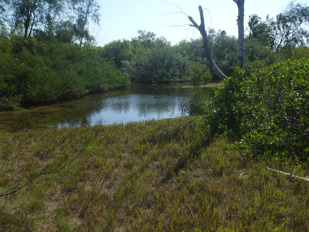
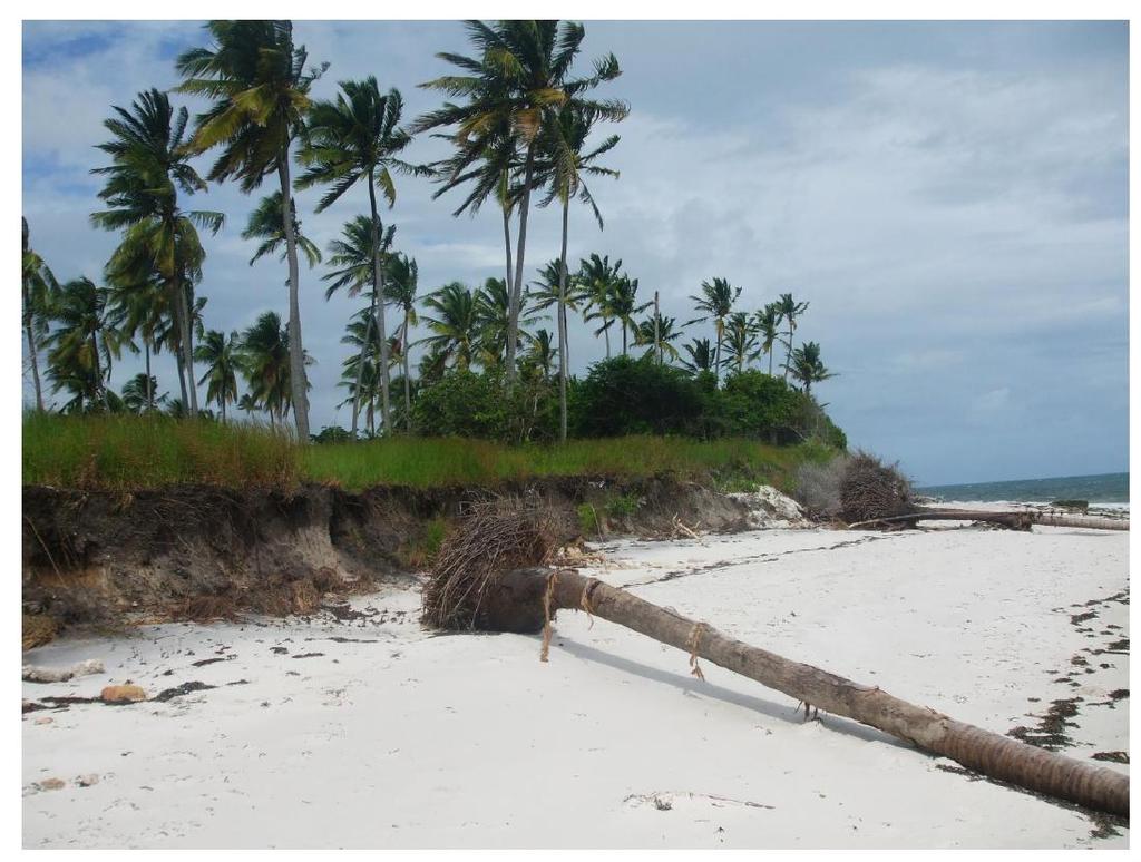
9
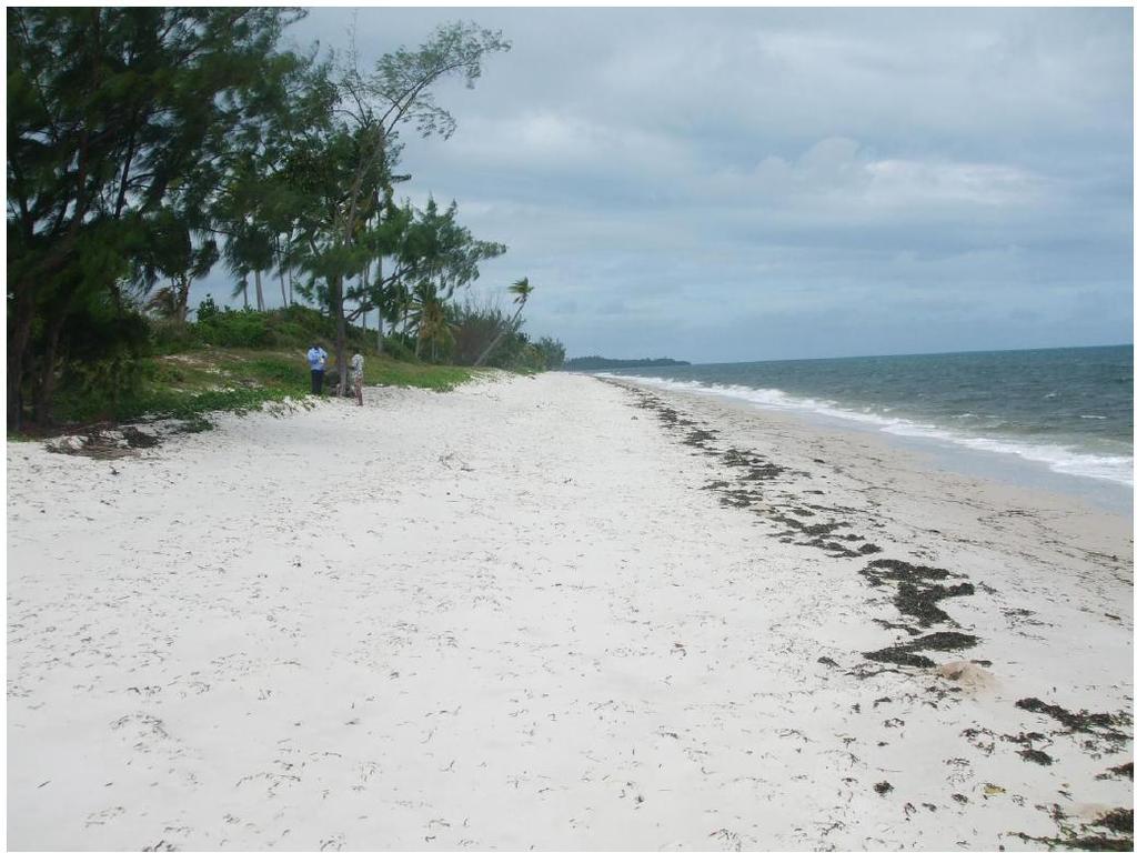
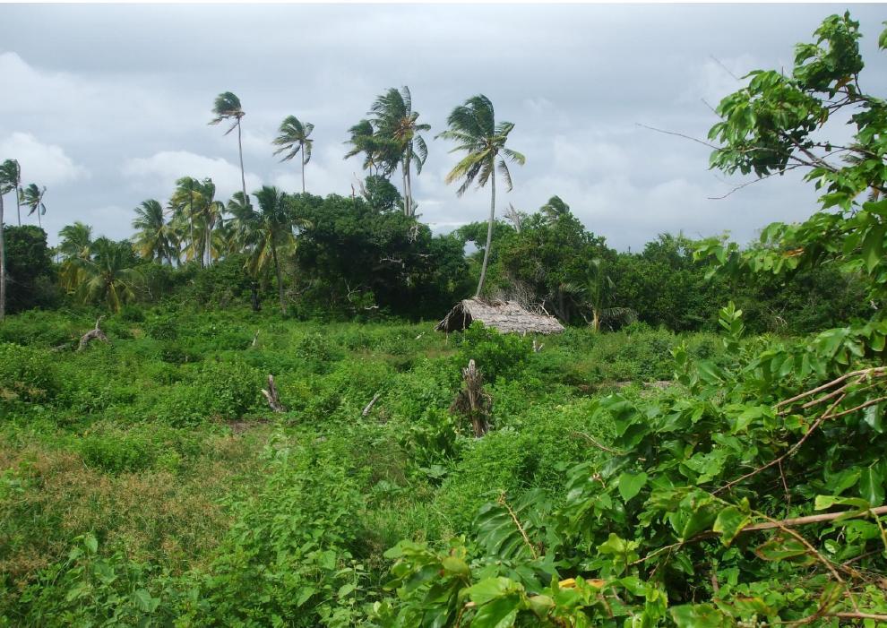
10


11 Do you have a structure that can function as a teaching facility, or other structures on site? We plan to build our structures using local materials such as mangrove, palmwood and leaves. Structures for our eco-resort will be like this: The structures for our dormitory and teaching facilities will be alike but with palmwood walls and interiour finishings. All buildings will be placed off ground. For now we have made a very premature lay- out for the food forest, school buildings and dormitories: Do you have a development fund, if so what is your budget, or proposed method of funding? At this moment we are in a very early stage, so we are open to any suggestions. We plan to get consultation for this matter.
12 What organizational or legal structures do you control, if any, that are relevant to this project? Real Estate development and building skills in whole. Businesses Building contracting Dar es Salaam Tanzania Fish processing Mwanza Tanzania Project developing in the Netherlands Real Estate in the Netherlands How many people are involved? At this time 4 people, when operational we figure about 120 locals and 15 staff, depending on how the forest needs to be maintained. What are their skills/experience level regarding permaculture? At this moment none, but willing to learn. What other relevant skill sets does your group have? Accounting, administration, computer skills like Autocad, Powerpoint etc. How much time do they have to work on this project? This will depend on demand.
Geography Policy 2014
 Geography Policy 2014 DEFINITION Geography education should inspire in pupils a curiosity and fascination about the world and its people that will remain with them for the rest of their lives. Teaching
FY SUMMARY BUDGET
 SCHOOL Cole Middle School Budgeted Pupil Count 461.0 BEGINNING FUND BALANCE (Includes ALL Reserves) Object/ Source 736,466.00 736,466.00 REVENUES Local Sources 1000-1999 584,080 584,079.95 Intermediate
Land use study of Mellieha Valley
 Land use study of Mellieha Valley Fieldwork Report 1 Land use study of Mellieha Valley Location: Date: Time: Apparatus: Weather Conditions: Objectives / Aims: Geography Option Fieldwork E Gilson 2 2 Geological
Level 1 Geography, 2013
 91010 910100 1SUPERVISOR S Level 1 Geography, 2013 91010 Apply concepts and basic geographic skills to demonstrate understanding of a given environment 9.30 am Friday 22 November 2013 Credits: Four Achievement
Utah Core Standards Science Grade: 4 - Adopted: 2002
 Main Criteria: Utah Core Standards Secondary Criteria: Subjects: Science, Social Studies Grade: 4 Correlation Options: Show Correlated UT.1. Utah Core Standards Science Grade: 4 - Adopted: 2002 Intended
Five Themes of Geography
 There are five themes of geography: location, place, region, movement, and humanenvironment interaction. These themes are important to geographers. The themes help them describe places. They help geographers
Tuition, Medical and Behaviour Support Service
 Tuition, Medical and Behaviour Support Service Curriculum Policy - Primary Geography Reviewed: October 2018 Next Review: October 2019 Responsibility: Andrea Snow AIMS AND PRINCIPLES The national curriculum
Rainforests and Deserts: Distribution, Uses, and Human Influences. Teacher s Masters California Education and the Environment Initiative
 E Teacher s Masters California Education and the Environment Initiative Earth Science Standard E.5.e. Rainforests and Deserts: Distribution, Uses, and Human Influences California Education and the Environment
How to Develop Master Sampling Frames using Dot Sampling Method and Google Earth
 How to Develop Master Sampling Frames using Dot Sampling Method and Google Earth Issei Jinguji. Agricultural statistics. JICA expert. Project for Capacity Development for the ASDP Monitoring and Evaluation
Coimisiún na Scrúduithe Stáit State Examinations Commission
 S28 Coimisiún na Scrúduithe Stáit State Examinations Commission JUNIOR CERTIFICATE EXAMINATION, 2003 GEOGRAPHY - HIGHER LEVEL MONDAY, 9 th JUNE - AFTERNOON, 1.30 TO 3.30 SECTION 2 (90 MARKS) Answer THREE
Five Themes of Geography of Ecuador
 LESSON 1 Five Themes of Geography of Ecuador Lesson Objective The students will be able to: find the five themes of geography (location, movement, human/environment interaction, place, and region) of Ecuador
Level 1 Geography, 2011
 91010 910100 1SUPERVISOR S Level 1 Geography, 2011 91010 Apply concepts and basic geographic skills to demonstrate understanding of a given environment 9.30 am ednesday Wednesday 2 November 2011 Credits:
name and locate the world s seven continents and five oceans
 Subject: Geography Activities National Curriculum Objectives One Progression of Skills Name the 7 continents and 5 oceans 3D Jigsaw task to locate continents and seas name and locate the world s seven
Ecological Site Description Overview
 Ecological Site Description Overview 2018 Coastal Zone Soil Survey (CZSS) Work Planning Conference Savannah, GA January 9th, 2018 Greg Taylor Senior Regional Soil Scientist USDA-NRCS Raleigh, NC j.greg.taylor@nc.usda.gov
About places and/or important events Landmarks Maps How the land is, hills or flat or mountain range Connected to maps World Different countries
 What do you think you know about geography? About places and/or important events Landmarks Maps How the land is, hills or flat or mountain range Connected to maps World Different countries What do you
Augmented Reality Sandbox
 NARARA VALLEY HIGH SCHOOL Augmented Reality Sandbox Diane.Twomey@det.nsw.edu.au Ph: 0428247478 29/03/2017 Narara Valley High School 1 The Development Process 29/03/2017 Narara Valley High School 2 It just
5 Themes of Geography Review Video Notes What is Geography?
 Name PG # 5 Themes of Geography Review Video Notes What is Geography? The study of, their, and their Main Idea or Topic Continents Notes about Main Idea or Topic There are 7 Continents or in the world:
St. James C of E Primary School
 St. James C of E Primary School Geography Policy St. James C of E Primary School Geography Policy Written by: Lisa Harford Written: April 2016 Reviewed: April 2018 1. Introduction Geography is concerned
THE UNITED REPUBLIC OF TANZANIA NATIONAL EXAMINATIONS COUNCIL CERTIFICATE OF SECONDARY EDUCATION EXAMINATION
 THE UNITED REPUBLIC OF TANZANIA NATIONAL EXAMINATIONS COUNCIL CERTIFICATE OF SECONDARY EDUCATION EXAMINATION 013 GEOGRAPHY (For School Candidates Only) Time: 3 Hours Tuesday, 8 th October 2009 p.m. Instructions
Barlows Primary School Geography Curriculum Content Key Stage 1 and
 Geography Curriculum Content Key Stage 1 and 2 2017-2018 Curriculum Content Year 1 The content for Year 1 is detailed below: WHAT ARE SEASONS? WHAT SIT LIKE WHERE WE LIVE? WHERE DO DIFFERENT ANIMALS LIVE?
Abbotswood Junior School National Curriculum 2014
 Geography Purpose A high-quality geography education should inspire in pupils a curiosity and fascination about the world and its people that will remain with them for the rest of their lives. Teaching
Nursery. Reception. Year 1
 Nursery Geography Overview Autumn Spring Summer Notices detailed features of objects in their environment. Comments and asks questions about aspects of their familiar world such as the place where they
Introducing GIS analysis
 1 Introducing GIS analysis GIS analysis lets you see patterns and relationships in your geographic data. The results of your analysis will give you insight into a place, help you focus your actions, or
St Joseph s R.C. Primary School. Policy for Geography
 St Joseph s R.C. Primary School Policy for Geography 2016-2017 This policy is written with consideration to our school commitment to the Rights of the Child and our achievement of becoming a Rights Respecting
Level 1 Geography, 2016
 91010 910100 1SUPERVISOR S Level 1 Geography, 2016 91010 Apply concepts and basic geographic skills to demonstrate understanding of a given environment 9.30 a.m. Wednesday 16 November 2016 Credits: Four
Geography Mile Post 1
 Mile Post 1 Use world maps, atlases and globes to identify the UK and its countries, as well as the countries, continents and oceans studied at this key stage Key Skills IPC learning Goals 1.11 Be able
Assessing state-wide biodiversity in the Florida Gap analysis project
 University of Nebraska - Lincoln DigitalCommons@University of Nebraska - Lincoln Nebraska Cooperative Fish & Wildlife Research Unit -- Staff Publications Nebraska Cooperative Fish & Wildlife Research Unit
STM Development: A Systematic Approach Focused on Quality Control
 STM Development: A Systematic Approach Focused on Quality Control A Lofty Aspiration Tamzen K. Stringham University of Nevada, Reno Multiple Approaches Dig lots of holes - I will figure this out! Hang
Geography Long Term Plan 2018
 Geography Long Term Plan 2018 Geography Co-ordinator: Megan Frost A high-quality geography education should inspire in pupils a curiosity and fascination about the world and its people that will remain
Geography. Programmes of study for Key Stages 1-3
 Geography Programmes of study for Key Stages 1-3 February 2013 Contents Purpose of study 3 Aims 3 Attainment targets 3 Subject content 4 Key Stage 1 4 Key Stage 2 5 Key Stage 3 6 2 Purpose of study A high-quality
Elementary Social Studies Content Area Assessment Task. Winter 2010 EDUC 203
 1 Elementary Social Studies Content Area Assessment Task Winter 2010 EDUC 203 Students: Fourth grade class in Watsonville, CA. Approximately 90% Latino, primarily of Mexicandescent. About 80% participate
Range of Opportunities
 Geograhy Curriculum Cropwell Bishop Primary School Range of Opportunities Year 1 Year 2 Year 3 Year 4 Year 5 Year 6 All Key Stage 1 Key Stage 2 Investigate the countries and capitals of the United Kingdom.
MEADOWS PRIMARY SCHOOL and NURSERY GEOGRAPHY POLICY
 MEADOWS PRIMARY SCHOOL and NURSERY GEOGRAPHY POLICY Purpose of study The teaching of Geography at Meadows is done by following the 2014 National Curriculum. The planning and teaching of the subject aims
Year 3 Geography Expectations
 Year 3 Geography Expectations Year 3 Geography Knowledge, Skills and Understanding Geographical Enquiry Physical Geography Human Geography Geographical Knowledge Do they use correct geographical words
Implementing Risk-adapted Land-use Planning and Urban Solutions for Dar es Salaam Synergies and Integration of Energy-Water-Food Security
 Dar es Salaam - Reality Check Workshop hosted by GIZ and Dar es Salaam City Council Implementing Risk-adapted Land-use Planning and Urban Solutions for Dar es Salaam Synergies and Integration of Energy-Water-Food
HOMEWORK CURRICULUM Geography
 HOMEWORK CURRICULUM Geography 2013-2014 Year 7 Term 1 Weather and Climate (will run 2-3 weeks into term 2) Make a mini weather station. Record the weather daily for 3 weeks Write a report on what the data
Brief report on Belize carbonate environments field trip Feb. 2012
 Brief report on Belize carbonate environments field trip Feb. 2012 In february 2012 I travelled to San Pedro (Ambergris Caye) Belize (Figure 1) to examine and study depositional environments of carbonate
Downloaded from
 SOCIAL STUDIESCLASS - V LESSON-1 GLOBE ANSWER THE FOLLOWING: 1. Name the continents and oceans on the earth. Ans. The seven continents are: a) Australia b) Europe c) Antarctica d) South America e) North
METEOROLOGICAL SERVICE DELIVERY Mozambique Model
 METEOROLOGICAL SERVICE DELIVERY Mozambique Model MOZAMBIQUE INSTITUTE OF METEOROLOGY (INAM) João Atanasio Manhique National Deputy Director atanasio_m@inam.gov.mz http://www.inam.gov.mz Workshop: Achieving
Storm and Runoff Calculation Standard Review Snowmelt and Climate Change
 Storm and Runoff Calculation Standard Review Snowmelt and Climate Change Presented by Don Moss, M.Eng., P.Eng. and Jim Hartman, P.Eng. Greenland International Consulting Ltd. Map from Google Maps TOBM
Portfolio of karteco Cadastral Survey Department
 Portfolio of karteco Cadastral Survey Department 01-2016 Who we are? karteco Environmental & Energy Engineering Consultancy Founding members: Apostolos Karteris Dr. Environmental Engineer Marinos Karteris
Polar Climate Zone. Temperate Climate Zone. Tropical Climate Zone. Temperate Climate Zone. Polar Climate Zone. 1st. 3 hottest cities 3 coldest cities
 Exploring the Influences on Climate Part 1: Predictions and Background 1.) Based on the map below, record what you predict to be the 3 hottest and coldest cities in the month of July. Polar Climate Zone
Use maps, atlases, globes and computer mapping to locate countries and describe features studied
 Roseberry Primary School Curriculum planning Lead Question: What s so amazing about America? National Curriculum driver: Geography Rationale statement: In this study about the amazing Americas, children
Geography Skills Progression. Eden Park Primary School Academy
 Geography Skills Progression Eden Park Primary School Academy In order to ensure broad and balanced coverage, we follow these principles: Within each phase, geography is a driver for at least 3 Learning
NEW. Junior Certificate Geography. LiamAshe Kieran McCarthy
 NEW Junior Certificate Geography LiamAshe Kieran McCarthy THE EDUCATIONAL COMPANY OF IRELAND Contents Section 1 Physical Geography Chapter 1 The Earth 1.1 The Solar System 1.2 The Structure of Earth 1.3
Mutah university faculty of Social Sciences The Study plan of the department of Geography 2006/2007
 Mutah university faculty of Social Sciences The Study plan of the department of Geography 2006/2007 Requirements university compulsory 22 Credit hours Course No Credit hours Prerequisite Requirements Faculty
Moreton Bay and Key Geographic Concepts Worksheet
 Moreton Bay and Key Geographic Concepts Worksheet The Australian Curriculum: Geography draws on seven key geographic concepts: place scale space environment change interconnection sustainability They are
1/28/16. EGM101 Skills Toolbox. Map types. Political Physical Topographic Climate Resource Road. Thematic maps (use one of the above as backdrop)
") EGM101 Skills Toolbox Map types Political Physical Topographic Climate Resource Road Thematic maps (use one of the above as backdrop) Map Types Deriving information from maps Hydrographic Geological Soils
EGM101 Skills Toolbox Map types Political Physical Topographic Climate Resource Road Thematic maps (use one of the above as backdrop) Map Types Deriving information from maps Hydrographic Geological Soils
The Geography Curriculum at Coston Primary
 The Geography Curriculum at Coston Primary Years Year 1 Year 2 Summer We are learning about where food is farmed and in The physical features of farms. The human features of farms. The characteristics
Federal Emergency Management Agency, Public Domain.
 Federal Emergency Management Agency, Public Domain. LIMITED LICENSE TO MODIFY. These PowerPoint slides may be modified only by teachers currently teaching the Science and Global Issues SEPUP course to
ST AMBROSE CATHOLIC PRIMARY SCHOOL Geography Policy
 ST AMBROSE CATHOLIC PRIMARY SCHOOL Geography Policy 2017-2018 Our school policy is developed in accordance with the National Curriculum for Geography and Foundation Stage Curriculum for Understanding of
Looking at Communities: Comparing Urban and Rural Neighborhoods
 Looking at Communities: Comparing Urban and Rural Neighborhoods OVERVIEW & OBJECTIVES Our urban areas have become so dominant that frequently the children we teach have no connection with and very few
One Hilltop, Three Major Watersheds!
 One Hilltop, Three Major Watersheds! Adapted from: An original Creek Connections activity. Creek Connections, Box E, Allegheny College, Meadville, Pennsylvania, 16335 Watersheds of PA/ Topo Map Review
SECTION DESCRIPTION PAGE I. BUDGET INTRODUCTION... 1 II. FISCAL YEAR 2017 BUDGET ANALYSIS... 2 III. FINAL OPERATING BUDGET... 3
 2018 SECTION DESCRIPTION PAGE I. BUDGET INTRODUCTION... 1 II. FISCAL YEAR 2017 BUDGET ANALYSIS... 2 III. FINAL OPERATING BUDGET... 3 IV. GENERAL FUND 001 DESCRIPTIONS... 4 Background Information The Four
5 THEMES OF GEOGRAPHY ACTIVITIES/BOOKLET
 5 THEMES OF GEOGRAPHY ACTIVITIES/BOOKLET Choose two activites from each theme to complete LOCATION: 1) Using latitude and longitude lines on a world map, locate and note the following: the highest mountain
Quantifying effects of oil on coastal dune vegetation. Thomas Miller and Elise Gornish Biological Science, Florida State University
 Quantifying effects of oil on coastal dune vegetation Thomas Miller and Elise Gornish Biological Science, Florida State University Natural History of Barrier Islands in the Northern Gulf Make up ~70% of
World Geography and Cultures Michigan Social Studies Grade Six Content Expectations - Geography
 World Geography and Cultures 2008 Correlated to Michigan Social Studies Grade Six Content Expectations - Geography 5910 Rice Creek Pkwy, Suite 1000 Shoreview, MN 55126 Copyright 2007 Pearson Education,
WELCOME TO THE 2018 RA-IV WORKSHOP ON HURRICANE FORECASTING AND WARNING
 WELCOME TO THE 2018 RA-IV WORKSHOP ON HURRICANE FORECASTING AND WARNING Richard J. Pasch and Daniel P. Brown Senior Hurricane Specialists National Hurricane Center ORIENTATION Use of PCs NHC Facility Workshop
Improvement of the National Hydrography Dataset for Parts of the Lower Colorado Region and Additional Areas of Importance to the DLCC
 Improvement of the National Hydrography Dataset for Parts of the Lower Colorado Region and Additional Areas of Importance to the DLCC Carlos Reyes-Andrade California State University, Northridge September
THE UNITED REPUBLIC OF TANZANIA NATIONAL EXAMINATIONS COUNCIL CERTIFICATE OF SECONDARY EDUCATION EXAMINATION
 THE UNITED REPUBLIC OF TANZANIA NATIONAL EXAMINATIONS COUNCIL CERTIFICATE OF SECONDARY EDUCATION EXAMINATION 013 GEOGRAPHY (For Both School and Private Candidates) TIME: 3 Hours Thursday, 9 th October
Geography Progression
 Geography Progression This document aims to track expectations for History within George Grenville Academy. What the National Curriculum says: KS1: Locational Knowledge: Name and locate the world s 7 continents
Year 9 plan Victorian Curriculum: Humanities Semester Two (Geography/Economics and Business)
") Year 9 plan Victorian Curriculum: Humanities Semester Two (Geography/Economics and Business) Implementation year: School name: Kyabram P-12 College Prepared By: Rowena Morris Identify Curriculum Curriculum
Year 9 plan Victorian Curriculum: Humanities Semester Two (Geography/Economics and Business) Implementation year: School name: Kyabram P-12 College Prepared By: Rowena Morris Identify Curriculum Curriculum
Geography Policy. Introduction
 Geography Policy Introduction Geography at St. Aloysius Federation School teaches an understanding of places and environments and aims to inspire a curiosity and fascination about the world and its people.
Stage 2 Geography. Assessment Type 1: Fieldwork. Student Response
 Stage 2 Geography Assessment Type 1: Fieldwork Student Response Page 1 of 21 Page 2 of 21 Page 3 of 21 Image removed due to copyright. Page 4 of 21 Image removed due to copyright. Figure 5: A cause of
Texas Geography. Understanding the physical and human characteristics of our state
 Texas Geography Understanding the physical and human characteristics of our state To understand Texas you must first learn about its Geography. Geography- The study of the world, its people, and the interaction
Minnesota K-12 Academic Standards in Social Studies. Grade 4: Geography of North America
 Minnesota K-12 Academic s in Social Studies Grade 4: Geography of North America 4 Describe how people take 1. Democratic government action to influence a depends on informed and decision on a specific
Factors that Shape Places (Blacktown) Stage 3 Geography
 Stage 3 Geography") Factors that Shape Places (Blacktown) Stage 3 Geography Summary This unit is written for Stage 3 "Factors that shape places". It is a Geographical Inquiry, enabling students to work through the 3 stages
Factors that Shape Places (Blacktown) Stage 3 Geography Summary This unit is written for Stage 3 "Factors that shape places". It is a Geographical Inquiry, enabling students to work through the 3 stages
RAINFORESTS. What are rainforests? Tall trees. What s the weather like? What else grows there?
 RAINFORESTS What are rainforests? Rainforests are very busy places. Half of the world s animals and plants live in rainforests. You will find birds, monkeys, apes, spiders and snakes here. A sleepy boa
GEOGRAPHY POLICY STATEMENT. The study of geography helps our pupils to make sense of the world around them.
 GEOGRAPHY POLICY STATEMENT We believe that the study of geography is concerned with people, place, space and the environment and explores the relationships between the earth and its peoples. The study
BLACK PEAR TRUST SUBJECT PLAN - GEOGRAPHY
 Purpose of Study A high-quality geography education should inspire in pupils a curiosity and fascination about the world and its people that will remain with them for the rest of their lives. Teaching
This table connects the content provided by Education Perfect to the NSW Syllabus.
 Education Perfect Geography provides teachers with a wide range of quality, engaging and innovative content to drive positive student learning outcomes. Designed by teachers and written by our in-house
Developing a Campus-wide Base Map for Planning, Design and Construction. June 21, 2007
 Developing a Campus-wide Base Map for Planning, Design and Construction June 21, 2007 Presenters Berent Pippert UCR Project Manager Capital and Physical Planning Academic Planning and Budget 951-827-2431
What can I do with a major in Earth Information Science?
 Lewis-Clark State College offers a Bachelor of Arts or Science Degree in Earth Information Science through the Natural Sciences and Mathematics Division. You can learn more about the Natural Sciences and
Digital Tax Maps Westport Island Project Summary
 Digital Tax Maps Westport Island Project Summary Presented to the: Mid-Coast Regional Planning Commission Creating GIS-Based Digital Tax Maps And Linked Assessment Records For Small Towns on a Budget Dennis
TANZANIA PETROLEUM DEVELOPMENT CORPORATION CAREER OPPORTUNITIES
 TANZANIA PETROLEUM DEVELOPMENT CORPORATION CAREER OPPORTUNITIES Tanzania Petroleum Development Corporation (TPDC) is a National oil company dealing with Oil and Gas exploration, development and production.
Trade Sustainability Impact Assessment in support of negotiations of a DCFTA between the EU and Egypt
 Trade Sustainability Impact Assessment in support of negotiations of a DCFTA between the EU and Egypt Annexes to the final Interim Technical Report Client: European Commission - DG TRADE Rotterdam, 30
THE UNITED REPUBLIC OF TANZANIA MINISTRY OF WORKS, TRANSPORT AND COMMUNICATION TANZANIA METEOROLOGICAL AGENCY
 THE UNITED REPUBLIC OF TANZANIA MINISTRY OF WORKS, TRANSPORT AND COMMUNICATION TANZANIA METEOROLOGICAL AGENCY CLIMATE OUTLOOK FOR TANZANIA MARCH MAY, 2018 MASIKA RAINFALL SEASON Highlights for March May,
Regional Centre for Mapping of Resources for Development (RCMRD), Nairobi, Kenya
, Nairobi, Kenya") Regional Centre for Mapping of Resources for Development (RCMRD), Nairobi, Kenya Introduction to GIS (2 weeks: 10 days) Intakes: 8 th January, 6 th February, 5th March, 3 rd. April 9 th, May 7 th, June
Regional Centre for Mapping of Resources for Development (RCMRD), Nairobi, Kenya Introduction to GIS (2 weeks: 10 days) Intakes: 8 th January, 6 th February, 5th March, 3 rd. April 9 th, May 7 th, June
Most people used to live like this
 Urbanization Most people used to live like this Increasingly people live like this. For the first time in history, there are now more urban residents than rural residents. Land Cover & Land Use Land cover
CURRICULUM VITAE Mthobeli Vaaltyn
 CURRICULUM VITAE Mthobeli Vaaltyn 2880 Dwarhane Street Browns Farm Philippi 7785 Cell: 071 3720 456 E-Mail: mvaaltyn4@gmail.com PERSONAL DETAILS Surname First Name(s) : Vaaltyn : Mthobeli Date of Birth
Directed Reading. Section: Types of Maps
 Skills Worksheet Directed Reading Section: Types of Maps 1. What are some of the characteristics of an area shown on maps used by Earth scientists? a. types of animals, types of plants, types of minerals
GIS Geographical Information Systems. GIS Management
 GIS Geographical Information Systems GIS Management Difficulties on establishing a GIS Funding GIS Determining Project Standards Data Gathering Map Development Recruiting GIS Professionals Educating Staff
Louisiana Academic Standards Science Grade: 4 - Adopted: 2017
 Main Criteria: Louisiana Academic Standards Secondary Criteria: Subjects: Science, Social Studies Grade: 4 Correlation Options: Show Correlated Louisiana Academic Standards Science Grade: 4 - Adopted:
The City School. Pakistan Studies 2059/02 Paper 2 The Environment of Pakistan Class 9
 The City School Prep + Senior -1Section Pakistan Studies 2059/02 Paper 2 The Environment of Pakistan Class 9 Name: Class: The City School /PAF Chapter / Prep + Senior I Section / Worksheet for Intervention
GEOGRAPHY POLICY. Date: March Signed: Review: March 2019
 GEOGRAPHY POLICY Date: March 2018 Signed: Review: March 2019 Aims At Hayton C of E Primary School we believe that Geography is an essential part of the curriculum and teachers ensure that the children
Author Jamey Acosta The articles in this book are collected from the TIME For Kids archives.
 Author Jamey Acosta The articles in this book are collected from the TIME For Kids archives. Table of Contents Introduction... 4 Teaching Nonfiction Comprehension Skills... 9 Teaching Vocabulary... 14
Ecological Succession
 Ecological Succession Most natural ecosystems are in a state of equilibrium. This means that their biotic and abiotic features remain relatively constant over time. The major biomes, for example, usually
Burnaby Online Program School District #41 Burnaby. Course: Geography 12 Course Length: 10 months (approx 100 hours) Teacher: Phone: IM:
 Teacher: Phone: IM:") Course Plan Burnaby Online Program School District #41 Burnaby Course: Geography 12 Course Length: 10 months (approx 100 hours) Teacher: Email: Phone: IM: Course Description: Lesson 1-1: Major Themes of
Course Plan Burnaby Online Program School District #41 Burnaby Course: Geography 12 Course Length: 10 months (approx 100 hours) Teacher: Email: Phone: IM: Course Description: Lesson 1-1: Major Themes of
HOLY CROSS CATHOLIC PRIMARY SCHOOL
 HOLY CROSS CATHOLIC PRIMARY SCHOOL Geography Policy Date Implemented Jan 17 Review Date Jan 22 Mission Statement Holy Cross Primary School is a Catholic School. We seek to provide a broad, balanced Christian
New National Curriculum Geography Skills Planning KS1
 New National Curriculum Geography Skills Planning KS1 Enquiry Question Objective-essential knowledge skills or understanding Locational Knowledge Standards /Success Criteria Lesson progression over half
Google Adwords. 8WEB Google Adwords. Capture leads & make sales. Y o u r P a r t n e r s I n O n l i n e S a l e s
 8WEB Google Adwords Capture leads & make sales 8WEB Google Adwords Y o u r P a r t n e r s I n O n l i n e S a l e s 0407 924 368 8web.com.au PO BOX 8, Callala Beach, NSW 2540 W H A T I S G O O G L E A
Lab Topographic Maps. Name: Partner: Purpose. Background Information
 Lab Topographic Maps Name: Partner: Purpose The purpose of this lab is to familiarize you with graphic representations of the Earth s surface primarily maps. Simple line maps show the spatial relationship
Frank Hegyi President, Ferihill Technologies Ltd Victoria, B.C.
 REMOTE SENSING TECHNIQUES IN ENVIRONMENTAL MONITORING By Frank Hegyi President, Ferihill Technologies Ltd Victoria, B.C. ABSTRACT Increasing public awareness about environmental concerns is creating pressures
Factors that Shape Places Stage 3 Geography
 Factors that Shape Places Stage 3 Geography Summary This unit is written for Stage 3 "Factors that shape places". It is a Geographical Inquiry, enabling students to work through the 3 stages of inquiry;
Procurement Plan. II. Thresholds for Prior Review, Procurement Approaches and Methods
 I. General Plan 1. Project Information Country: Tanzania Project Name: Second Water Sector Support Project (WSSP II) Project ID: P150361 2. Project Agency: Ministry of Water and Irrigation Dar es Salaam
alter collapse destruction severe substantial unpredictable hazard crisis Finish each sentence using the vocabulary word provided.
 Vocabulary alter collapse destruction severe substantial unpredictable hazard crisis Finish each sentence using the vocabulary word provided. 1. (alter) When she saw that it was going to rain, 2. (collapse)
UNIVERSITY OF CAMBRIDGE INTERNATIONAL EXAMINATIONS General Certificate of Education Ordinary Level
 UNIVERSITY OF CAMBRIDGE INTERNATIONAL EXAMINATIONS General Certificate of Education Ordinary Level *1795060869* GEOGRAPHY 2217/22 Paper 2 May/June 2013 Candidates answer on the Question Paper. Additional
Changes in Texas Ecoregions Copy the questions and answers
 Changes in Texas Ecoregions Copy the questions and answers 1. What are some kinds of damage that hurricanes cause? Roads and bridges might be washed away. Trees and power lines can be knocked down. Area
Geography Teach Yourself Series Topic 4: Global Distribution of Land Cover
 Geography Teach Yourself Series Topic 4: Global Distribution of Land Cover A: Level 14, 474 Flinders Street Melbourne VIC 3000 T: 1300 134 518 W: tssm.com.au E: info@tssm.com.au TSSM 2016 Page 1 of 7 Contents
Year 7 GEOGRAPHY Skills Booklet Assessment Task
 Year 7 GEOGRAPHY Skills Booklet Assessment Task Year/ Subject: Year 7 Geography Task - Skills Booklet Task Weighting: 20% Due Date: T2 W1 2018 Geographical Tools 10% Communication 10% TOTAL FOR TASK 20%