Thanksgiving Snow and Arctic Front 25 November 2005 By Richard H. Grumm National Weather Service State College, PA 16801
|
|
|
- Jacob Hancock
- 5 years ago
- Views:
Transcription
1 Thanksgiving Snow and Arctic Front 25 November 2005 By Richard H. Grumm National Weather Service State College, PA INTRODUCTION An approaching arctic front brought light snow to most of western and central Pennsylvania on Thanksgiving eve and early on Thanksgiving data. Snowfall with the approaching system was generally on the order of 25 to 75 mm (1-3 inches). The arctic front, with strong gusty winds, on the order of 35-45KTS came through State College around 1900 UTC. Temperatures fell rapidly behind the front and the melting snow quickly froze. This led to numerous traffic accidents throughout central Pennsylvania during the afternoon hours. Behind the front, temperatures fell well below normal with many locations approaching near record low values on the morning of the 25 th. Lake effect snow (LES) impacted Ohio, New York, and northwestern Pennsylvania. A few locations in the State College County warning area (WFOCTP), in Warren County received 6-12 inches of snow. The higher snow fall amounts were near and along the New York border. This paper will document the thanksgiving snow and arctic front. It will also document some short-term ensemble forecast tools which were useful in forecasting this event. 2. METHOD Observational data was retrieved off the WFOCTP Advanced Weather Interactive and Processing System (AWIPS). Using case playback mode, a mix of radar, satellite, and surface observations were used to document the event. From a forecast perspective, data will be limited to forecasts from the National Centers for Environmental Predictions (NCEP) short-term ensemble forecast (SREF) system (SREF). These data are displayed using GrADS. A mix of ensemble output is produced and some of these data include the departure of the ensemble mean fields from the 30-year climatological values in standard deviations (SDs) from normal. 3. OVERVIEW Based on surface and radar observations, light snow moved across southwestern Pennsylvania during the late afternoon and evening hours of 23 November The snow spread to the northeast as a quasi northwest to southeast oriented series of snow bands. The snow shield, with embedded stronger bands is shown at 24/0000 and 24/0200 UTC in Figure 1. Steady light snow reached to State College around 24/0200 and the snow continued to move northeastward. A more organized are of snow moved over the region between 24/0400 and 24/0600 UTC with a large area of 30dBZ returns. The stronger bands can be seen in the radar imagery displayed in Figure 2. A sharp back edge to the precipitation shied was visible on radar


2 feature moved rapidly to the east. Observations showed very light snow or flurries west of this feature. This feature passed through KJST around 0615 and State College around After 24/0700 UTC the area to the west began to fill in with weak returns. Observations showed areas of drizzle, freezing drizzle, and light snow in the warmer moist air. Most of the accumulating snow was observed with this feature. By 0800 UTC this steady and accumulating snow had moved off to the east leaving a good 1-3 inch snowfall over the region. Temperatures slowly rose to near or a few degrees above freezing during the morning and early afternoon hours ahead of the approaching artic front. Figure 3 shows the visual satellite image from 25/1600 UTC. Most of the region was cloud free allowing the snowfall across Ohio, West Virginia, and Pennsylvania. Some LES bands were present over northwestern Pennsylvania as well some distinct LES bands over Lakes Superior, Huron, Erie and Ontario. Figure 1 KCCX composite reflectivity and surface observations valid at a) 0000 and b) 0200 UTC 24 November to the west (Fig. 2 lower panel) and this Figure 4 shows the surface observations at 1700 and 2000 UTC. The 1700 data is underplayed with GOES visual imagery. These data show the strong gusty northwest winds along and behind the arctic front. The rapidly falling


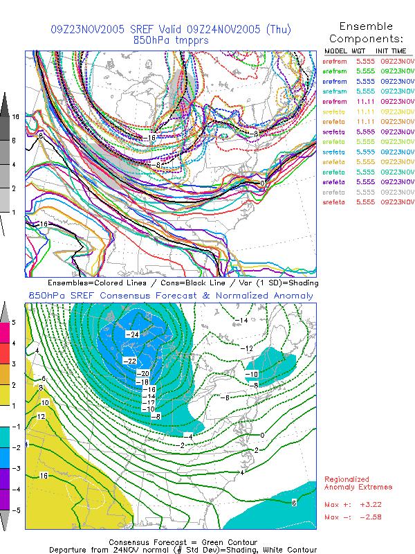
3 leading to numerous traffic accidents. At University Park airport, the temperature fell from 36 to 25F between 1700 and 2000 UTC. 4. SREF FORECASTS Figure 5 shows the 23/0900 UTC SREF forecasts of MSLP and 850 hpa temperatures valid at 24/1500 UTC. These data show the deep surface cyclone (-3.5 to -4 SDs below normal) passing over Lake Ontario, and the cold air at 850 hpa over the Great Lakes. The leading edge of this arctic air mass was crossing Pennsylvania at this time. Figure 2 As in Figure 1 except composite reflectivity valid at 0500 and 0.5 degree data valid at 0636 UTC. temperatures produced icy conditions Figure 6 shows plume diagrams of accumulated precipitation, colored by type and 2m temperature forecasts for State College, PA also from the SREF at 23/0900 UTC. The precipitation forecasts shows light precipitation beginning around 24/00000 UTC with most members showing the time of maximum precipitation between 0300 and 1200 UTC. All SREF members forecast snow. The mean was around 0.27 inches with a first guess of 2.7 inches of snow and the range was (10:1 ratio) about 1.0 to 4 inches of snow.

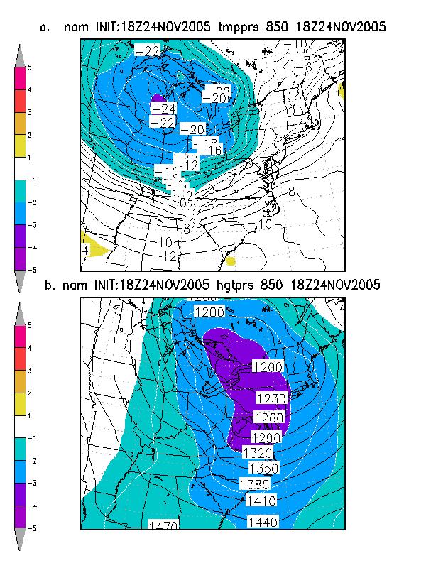
4 Figure 3 GOES visual imagery valid at 1615 UTC 25 November Except for some cirrus and narrow lake effect snow bands, most of the snow coverage from Ohio and West Virginia is visible in this image. The lower panel of Figure 6 shows little temperature change overnight with rising temperatures, due to the warm advection associated with the snow. The normal time for the overnight low is close to the time of the high for the day. The SREFs quite consistently forecast the precipitous fall of temperatures associated with the passage of the arctic front around 24/1500 UTC. Figure 7 shows the SREF wind forecasts valid at 24/1500 UTC. North of the cyclone, anomalous U-winds were forecast. Southwest of the surface cyclone anomalous west-northwest winds were forecast. These strong winds translated to near the surface along and behind the front as indicated in Figure 4. Figure 8 shows the SREF 850 hpa forecasts valid on Friday 25 November These data show the unseasonably cold air mass the settled over the region


5 for the day. This led to overnight lows Thursday into Friday that were close to record low values and high temperatures 25 November This provided a White Thanksgiving for many locations of the state. An arctic air mass swept Figure 5 SREF forecasts of MSLP (hpa) and 850 hpa temperatures (C) from forecasts initialized at 0900 UTC 23 November Upper panels show spaghetti and spread and lower panels show ensemble mean and the departures from normal in standard deviations from normal. that were about 20F below normal for the date. This cold air mass, with 850 hpa temperatures near -14C produced the instability over the Great Lake contributing to the LES bands shown in Figure CONCLUSIONS A fast moving clipper storm brought 1 to 3 inches of snow across much of western and central Pennsylvania during the evening and early overnight hours of 24- across the State during the afternoon and early evening hours of the 25 th. Strong gusty winds buffeted the region along and several hours behind the cold front. The NCEP SREF, using the forecasts initialized at November 2005, did an excellent job on forecasting the potential snow, the strong cold front, the strong winds associated with the cold front, the unseasonably cold temperatures behind the front, and the potential for Lake Effect snows.
6 Figure 6. SREF plumes from forecasts initialized at 0900 UTC 23 November Upper plume shows accumulated precipitation color coded by precipitation type and instantaneous 3-hour precipitation (gray) from each member. Lower panel shows 2m temperatures by member. The thick black line is the ensemble mean value. Return to text. Furthermore, the SREF plumes, as demonstrated by the plume for State College (other locations were examined but not shown) demonstrated the shortterm forecast utility of point data forecasts from the SREFs. The potential value of plumes in short-term weather forecasts for timing and high probability time of precipitation along with frontal passages appears to hold great promise.


7 Figure 4. Surface observations centered over Pennsylvania at 1700 and 2000 UTC 24 November GOES visual picture is underplayed with the 1700 UTC data. Return to text.
 and V (lower) winds from")

8 Figure 7 SREF forecasts initialized at 23/0900 valid at 24/1500 UTC showing ensemble mean winds and departures of the U (upper) and V (lower) winds from normal in standard deviations from normal. Return to text. Figure 8 As in Figure 7 except SREF 850 hpa temperature forecasts initialized at 23/0900 valid at 25/1200 UTC. Return
9
Severe Weather with a strong cold front: 2-3 April 2006 By Richard H. Grumm National Weather Service Office State College, PA 16803
 Severe Weather with a strong cold front: 2-3 April 2006 By Richard H. Grumm National Weather Service Office State College, PA 16803 1. INTRODUCTION A strong cold front brought severe weather to much of
Winter Storm of 15 December 2005 By Richard H. Grumm National Weather Service Office State College, PA 16803
 Winter Storm of 15 December 2005 By Richard H. Grumm National Weather Service Office State College, PA 16803 1. INTRODUCTION A complex winter storm brought snow, sleet, and freezing rain to central Pennsylvania.
Isolated severe weather and cold air damming 9 November 2005 By Richard H. Grumm National Weather Service Office State College, PA 16801
 Isolated severe weather and cold air damming 9 November 2005 By Richard H. Grumm National Weather Service Office State College, PA 16801 1. INTRODUCTION Two lines of convection moved over the State of
09 December 2005 snow event by Richard H. Grumm National Weather Service Office State College, PA 16803
 09 December 2005 snow event by Richard H. Grumm National Weather Service Office State College, PA 16803 1. INTRODUCTION A winter storm produced heavy snow over a large portion of Pennsylvania on 8-9 December
1. INTRODUCTION * Figure 1. National Weather Service Storm Prediction Center (SPC) storm reports for December 1, 2006.
 storm reports for December 1, 2006.") P1.14 FORECAST ISSUES RELATED TO THE UNPRECEDENTED SEVERE AND HIGH WIND EVENT OF DECEMBER 2006 by Greg A. DeVoir* and Richard H. Grumm National Weather Service Office State College, PA 16803 1. INTRODUCTION
P1.14 FORECAST ISSUES RELATED TO THE UNPRECEDENTED SEVERE AND HIGH WIND EVENT OF DECEMBER 2006 by Greg A. DeVoir* and Richard H. Grumm National Weather Service Office State College, PA 16803 1. INTRODUCTION
Northeastern United States Snowstorm of 9 February 2017
 Northeastern United States Snowstorm of 9 February 2017 By Richard H. Grumm and Charles Ross National Weather Service State College, PA 1. Overview A strong shortwave produced a stripe of precipitation
Cold frontal Rainband and Mid-Atlantic Severe Weather Event 28 September 2006 by Richard H. Grumm And Ron Holmes
 Cold frontal Rainband and Mid-Atlantic Severe Weather Event 28 September 2006 by Richard H. Grumm And Ron Holmes 1. INTRODUCTION A strong cold front moved across central Pennsylvania and the Mid-Atlantic
Minor Winter Flooding Event in northwestern Pennsylvania January 2017
 1. Overview Minor Winter Flooding Event in northwestern Pennsylvania 12-13 January 2017 By Richard H. Grumm National Weather Service State College, PA A combination of snow melt, frozen ground, and areas
Heavy rains and precipitable water anomalies August 2010 By Richard H. Grumm And Jason Krekeler National Weather Service State College, PA 16803
 Heavy rains and precipitable water anomalies 17-19 August 2010 By Richard H. Grumm And Jason Krekeler National Weather Service State College, PA 16803 1. INTRODUCTION Heavy rain fell over the Gulf States,
Low-end derecho of 19 August 2017
 Low-end derecho of 19 August 2017 By Richard H. Grumm and Charles Ross National Weather Service State College, PA 1. Overview A cluster of thunderstorms developed in eastern Ohio around 1800 UTC on 19
Mesoscale Convective System and heat episode July 2005 by Richard H. Grumm and Mathew Steinbugl
 Mesoscale Convective System and heat episode 25-27 July 2005 by Richard H. Grumm and Mathew Steinbugl 1. INTRODUCTION A strong upper-level ridge brought unseasonably high temperatures to the Midwest and
Summary of November Central U.S. Winter Storm By Christopher Hedge
 Summary of November 12-13 2010 Central U.S. Winter Storm By Christopher Hedge Event Overview The first significant snowfall of the 2010-2011 season affected portions of the plains and upper Mississippi
Heavy Rainfall Event of June 2013
 Heavy Rainfall Event of 10-11 June 2013 By Richard H. Grumm National Weather Service State College, PA 1. Overview A 500 hpa short-wave moved over the eastern United States (Fig. 1) brought a surge of
1. INTRODUCTION. For brevity times are referred to in the format of 20/1800 for 20 August UTC. 3. RESULTS
 Heavy rains and precipitable water anomalies 20-23 August 2010-Draft By Jason Krekeler And Richard Grumm National Weather Service State College, PA 16803 1. INTRODUCTION Heavy rain fell across the central
Mid Atlantic Severe Event of 1 May 2017 Central Pennsylvania QLCS event By Richard H. Grumm National Weather Service, State College, PA 16803
 1. Overview Mid Atlantic Severe Event of 1 May 2017 Central Pennsylvania QLCS event By Richard H. Grumm National Weather Service, State College, PA 16803 A strong upper-level wave (Fig.1) moving into a
Southern United States Winter Storm of 28 January 2014-v1. High Impact Snow on Edge of Forecast Precipitation Shield
 Southern United States Winter Storm of 28 January 2014-v1 High Impact Snow on Edge of Forecast Precipitation Shield by Richard H. Grumm National Weather Service State College, PA 16803 and 1. Introduction
Early May Cut-off low and Mid-Atlantic rains
 Abstract: Early May Cut-off low and Mid-Atlantic rains By Richard H. Grumm National Weather Service State College, PA A deep 500 hpa cutoff developed in the southern Plains on 3 May 2013. It produced a
Mid-Atlantic Ice Storm 4 March 2015
 1. Overview Mid-Atlantic Ice Storm 4 March 2015 By Richard H. Grumm National Weather Service State College, PA A large 500 hpa ridge over the southern United States (Fig. 1a-e)) built into the Mid-Atlantic
16 September 2005 Northern Pennsylvania Supercell Thunderstorm by Richard H. Grumm National Weather Service Office State College, PA 16803
 16 September 2005 Northern Pennsylvania Supercell Thunderstorm by Richard H. Grumm National Weather Service Office State College, PA 16803 1. INTRODUCTION During the afternoon hours of 16 September 2005,
Deep Cyclone and rapid moving severe weather event of 5-6 June 2010 By Richard H. Grumm National Weather Service Office State College, PA 16803
 Deep Cyclone and rapid moving severe weather event of 5-6 June 2010 By Richard H. Grumm National Weather Service Office State College, PA 16803 1. INTRODUCTION A rapidly deepening surface cyclone raced
The Long-lived eastern US tornadic supercell of 20 July 2017
 1. Overview The Long-lived eastern US tornadic supercell of 20 July 2017 By Richard H. Grumm and Elissa A Smith National Weather Service State College, PA A long lived supercell developed near the eastern
Winter Storm of February 2008 By Richard H. Grumm National Weather Service Office State College PA 16803
 1. INTRODUCTION Winter Storm of 11-13 February 2008 By Richard H. Grumm National Weather Service Office State College PA 16803 A potent winter storm brought snow, sleet, freezing rain, and rain to the
Impacts of the April 2013 Mean trough over central North America
 Impacts of the April 2013 Mean trough over central North America By Richard H. Grumm National Weather Service State College, PA Abstract: The mean 500 hpa flow over North America featured a trough over
Warm Episode of December 2015:
 Warm Episode of 11-16 December 2015: Record Warmth over Mid-Atlantic Region By Richard H. Grumm National Weather Service State College, PA 1. Overview A strong 500 hpa ridge over the eastern United States
Mid Atlantic Heavy rainfall event 1. Overview 2. Methods and Data 3. Pattern
 1. Overview Mid Atlantic Heavy rainfall event With an inertial gravity wave? By Richard H. Grumm National Weather Service, State College, PA 16803 Contributions from the Albany MAP An unseasonably strong
Eastern United States Winter Storm of 1-2 February 2015-DRAFT Northeast Ground Hog Storm
 Eastern United States Winter Storm of 1-2 February 2015-DRAFT Northeast Ground Hog Storm By Richard H. Grumm National Weather Service State College, PA 1. Overview A major Winter Storm brought precipitation
Snow, freezing rain, and shallow arctic Air 8-10 February 2015: NCEP HRRR success story
 Snow, freezing rain, and shallow arctic Air 8-10 February 2015: NCEP HRRR success story By Richard H. Grumm National Weather Service State College, PA 1. Overview A short-wave (Fig. 1) moved over the strong
Memorial Day Weekend 2013: Snow and Cold
 Abstract: Memorial Day Weekend 2013: Snow and Cold By Richard H. Grumm National Weather Service State College, PA A slow moving 500 hpa low and associated unseasonably cold air in the lower troposphere
Pre-Christmas Warm-up December 2013-Draft
 Pre-Christmas Warm-up 21-23 December 2013-Draft By Richard H. Grumm National Weather Service State College, PA 1. Overview A large ridge over the west-central Atlantic (Fig.1) and trough moving into eastern
National Weather Service-Pennsylvania State University Weather Events
 National Weather Service-Pennsylvania State University Weather Events Historic Ohio Valley January Severe weather and Tornado Event by Richard H. Grumm National Weather Service State College PA 16803 and
Severe Weather Event of 13 July 2014
 Severe Weather Event of 13 July 2014 By Richard H. Grumm and Elyse M. Colbert National Weather Service State College, PA 1. Overview Severe weather affected the eastern United States (Fig. 1) from northwestern
National Weather Service-Pennsylvania State University Weather Events
 National Weather Service-Pennsylvania State University Weather Events Heavy rainfall of 23 November 2011 by Richard H. Grumm National Weather Service State College PA 16803 Abstract:. A fast moving mid-tropospheric
A summary of the heat episodes of June 2017
 A summary of the heat episodes of June 2017 By Richard H. Grumm and Elissa A. Smith National Weather Service State College, PA 1. Overview Over 1800 record high temperatures were set or tied during the
Forecast for 6/28-7/31. Forecaster: Matthew Brewer Forecast made at: 12z 6/27/2017
 Forecast for 6/28-7/31 Forecaster: Matthew Brewer Forecast made at: 12z 6/27/2017 Whiteface lodge Mesonet Meteogram for the past 24 hours http://www.nysmesonet.org/data/meteogram#?stid=wfmb Whiteface Summit
Mid-West Heavy rains 18 April 2013
 Abstract: Mid-West Heavy rains 18 April 2013 By Richard H. Grumm and Charles Ross National Weather Service State College, PA The relatively wet conditions during the first 16 days of April 2013 set the
The Severe Weather Event of 7 August 2013 By Richard H. Grumm and Bruce Budd National Weather Service State College, PA 1. INTRODUCTION and Overview
 The Severe Weather Event of 7 August 2013 By Richard H. Grumm and Bruce Budd National Weather Service State College, PA 1. INTRODUCTION and Overview A fast moving short-wave (Fig. 1) with -1σ 500 hpa height
The Spring Storm of April 2007 By Richard H. Grumm National Weather Service Office State College PA 16803
 The Spring Storm of 13-16 April 2007 By Richard H. Grumm National Weather Service Office State College PA 16803 1. INTRODUCTION A major spring storm struck the eastern United States from 13 through 16
National Weather Service-Pennsylvania State University Weather Events
 National Weather Service-Pennsylvania State University Weather Events The February Thaw 17-19 February 2011 by Richard H. Grumm National Weather Service State College PA 16803 Abstract: After a cold January
Indiana County Flash Flood of 22 June 2017
 Indiana County Flash Flood of 22 June 2017 By Richard H. Grumm National Weather Service State College, PA 1. Overview Slow moving thunderstorms brought 3 to 4 inches of rainfall to Indiana County, PA during
National Weather Service-Pennsylvania State University Weather Events
 National Weather Service-Pennsylvania State University Weather Events Heavy Rain 7-8 December 2011 by Richard H. Grumm National Weather Service State College PA 16803 Abstract:. A mid-level short-wave
Mid-Atlantic Severe Weather Event of 23 June 2015
 Mid-Atlantic Severe Weather Event of 23 June 2015 By Richard H. Grumm National Weather Service State College, PA 1. Overview A widespread severe weather event occurred in the eastern United States on 23
The Pennsylvania Observer
 The Pennsylvania Observer April 2, 2009 March 2009 Pennsylvania Weather Recap Prepared by Curt Harpster For the month of March the saying, In like a lion and out like a lamb really fit the pattern quite
Weather Briefing for Pennsylvania January 5-8, 2014 Prepared 01/05/14 (1:30 PM EST)
") Weather Briefing for Pennsylvania January 5-8, 2014 Prepared 01/05/14 (1:30 PM EST) Prepared by: National Weather Service State College, PA (john.lacorte@noaa.gov) Latest Radar Latest Surface Weather Plots
Weather Briefing for Pennsylvania January 5-8, 2014 Prepared 01/05/14 (1:30 PM EST) Prepared by: National Weather Service State College, PA (john.lacorte@noaa.gov) Latest Radar Latest Surface Weather Plots
1. INTRODUCTION. In addition to the severe weather, the
 Anomalous Low and its weather impacts 10-12 May 2008 By Richard Grumm National Weather Service Office State College, PA And Al Cope National Weather Service Office Mount Holly, NJ 1. INTRODUCTION An unusually
Heavy Rainfall and Flooding of 23 July 2009 By Richard H. Grumm And Ron Holmes National Weather Service Office State College, PA 16803
 Heavy Rainfall and Flooding of 23 July 2009 By Richard H. Grumm And Ron Holmes National Weather Service Office State College, PA 16803 1. INTRODUCTION Heavy rains fall over Pennsylvania and eastern New
Eastern United States Ice Storm of December 2008 By Richard H. Grumm National Weather Service State College, PA 16803
 Eastern United States Ice Storm of 11-12 December 2008 By Richard H. Grumm National Weather Service State College, PA 16803 1. INTRODUCTION A significant ice storm affected the eastern United States on
Hurricane Harvey the Name says it all. by Richard H. Grumm and Charles Ross National Weather Service office State College, PA
 Hurricane Harvey the Name says it all by Richard H. Grumm and Charles Ross National Weather Service office State College, PA 16803. 1. Overview Hurricane Harvey crossed the Texas coast (Fig. 1) as a category
Orographically enhanced heavy rainfall of 23 May 2010 By Richard H. Grumm National Weather Service Office State College, PA 16803
 Orographically enhanced heavy rainfall of 23 May 2010 By Richard H. Grumm National Weather Service Office State College, PA 16803 1. INTRODUCTION During the overnight hours and into the early morning of
2 July 2013 Flash Flood Event
 2 July 2013 Flash Flood Event By Richard H. Grumm and Charles Ross National Weather Service State College, PA 1. Overview A retrograding 500 hpa cyclone and anticyclone (Fig. 1) set up deep southerly flow
Ensemble Forecasts of the Blizzard of January 2005 By Richard H. Grumm National Weather Service State College Pennsylvania
 Ensemble Forecasts of the Blizzard of 22-23 January 2005 By Richard H. Grumm National Weather Service State College Pennsylvania 1. Introduction A fast moving upper-level disturbance produced a wide area
Eastern United States Wild Weather April 2014-Draft
 1. Overview Eastern United States Wild Weather 27-30 April 2014-Draft Significant quantitative precipitation bust By Richard H. Grumm National Weather Service State College, PA and Joel Maruschak Over
Eastern United States Anafrontal Snow 4-5 March 2015-Draft
 Eastern United States Anafrontal Snow 4-5 March 2015-Draft By Richard H. Grumm National Weather Service State College, PA 1. Overview A 500 hpa ridge over the western Atlantic (Fig. 1) and an approaching
January 2006 Climate Summary
 Ashley Brooks (765) 494-6574 Feb 9, 2006 http://www.iclimate.org January 1-3 January 2006 Climate Summary Unseasonably warm conditions welcomed in the New Year with highs in the 40s across the northern
National Weather Service-Pennsylvania State University Weather Events
 National Weather Service-Pennsylvania State University Weather Events Eastern United States Winter Storm and Severe Event of 28-29 February 2012 by Richard H. Grumm National Weather Service State College
January 2008 Climate Summary
 Joseph Mays (765) 494-6574 Feb 5, 2008 http://www.iclimate.org Summary January 2008 Climate Summary January was a mix bag of conditions, with an oscillatory pattern developing. We experienced phases of
The enduring fog and low cloud episode of 5-10 December 2015: Big Bubble Fog Trouble
 1. Overview The enduring fog and low cloud episode of 5-10 December 2015: Big Bubble Fog Trouble By Richard H. Grumm National Weather Service State College, PA An enduring low cloud and fog episode affected
NCEP Short-Range Ensemble forecasts of an historic rainfall event: The June 2006 East Coast Floods 1. INTRODUCTION
 NCEP Short-Range Ensemble forecasts of an historic rainfall event: The 23-27 June 2006 East Coast Floods By Richard H. Grumm National Weather Service Office, State College PA 16803 And Norman W. Junker
Historic Eastern United States Winter Storm of January 2016: Record snow along the megalopolitan corridor 1. Introduction
 Historic Eastern United States Winter Storm of 22-24 January 2016: Record snow along the megalopolitan corridor by Richard H. Grumm National Weather Service State College, PA 16803 1. Introduction An historic
Winter Storm Briefing #3 Monday Evening Wednesday Evening
 Winter Storm Briefing #3 Monday Evening Wednesday Evening Tuesday March 14, 2017 Disclaimer: The information contained within this briefing is time-sensitive. Do not use after 4AM Wednesday. Applies to
Utilizing Ensemble-based Anomalies to Anticipate Significant Events A New Display Tool
 Utilizing Ensemble-based Anomalies to Anticipate Significant Events A New Display Tool Randy Graham 1, Rich Grumm 2, Nanette Hosenfeld 1, Trevor Alcott 3 1 NOAA/NWS Salt Lake City UT 2 NOAA/NWS State College
New Zealand Heavy Rainfall and Floods
 New Zealand Heavy Rainfall and Floods 1. Introduction Three days of heavy rainfall associated with a deep upper-level low (Fig. 1) brought flooding to portions of New Zealand (Fig. 2). The flooding was
Thanksgiving Eve snow of November 2014
 1. Overview Thanksgiving Eve snow of 26-27 November 2014 By Richard H. Grumm National Weather Service State College, PA An early season east coast winter storm (ECWS: DeGaetano et al. 2002) brought snow
1. INTRODUCTION. The super storm of March 1993 produced severe weather and tornadoes as it s trailing cold front pushed through Florida (Kocin eta 1l
 1. INTRODUCTION Super Tuesday and awful Wednesday: the 5-6 February 2008 Severe Weather Outbreak By Richard H. Grumm National Weather Service State College, PA And Seth Binau National Weather Service,
Tropical Storm Hermine: Heavy rainfall in western Gulf By Richard H. Grumm National Weather Service Office State College, PA 16803
 Tropical Storm Hermine: Heavy rainfall in western Gulf By Richard H. Grumm National Weather Service Office State College, PA 16803 1. INTRODUCTION Tropical storm Hermine, the eighth named tropical system
Heat wave ending severe events of July 2010 By Richard H. Grumm National Weather Service Office State College, PA 16803
 Heat wave ending severe events of 23-25 July 2010 By Richard H. Grumm National Weather Service Office State College, PA 16803 1. INTRODUCTION A strong subtropical ridge (Fig. 1a) dominated the eastern
The Pennsylvania Observer
 The Pennsylvania Observer August 3, 2015 July 2015 - Pennsylvania Weather Recap By: Arthur Person Although this seventh month of 2015 was fairly normal across Pennsylvania as a whole, the details reveal
NWS-PSU Case Study Site 2010 Severe Weather Case
 NWS-PSU Case Study Site 2010 Severe Weather Case New Years Eve Severe Weather Event of 31 December 2010 by Richard H. Grumm National Weather Service State College PA 16083 Abstract: A surge of warm humid
The Pennsylvania Observer
 The Pennsylvania Observer January 5, 2009 December 2008 Pennsylvania Weather Recap The final month of 2008 was much wetter than average and a bit colder than normal. In spite of this combination, most
Mid-Latitude Cyclones and Fronts. Lecture 12 AOS 101
 Mid-Latitude Cyclones and Fronts Lecture 12 AOS 101 Homework 4 COLDEST TEMPS GEOSTROPHIC BALANCE Homework 4 FASTEST WINDS L Consider an air parcel rising through the atmosphere The parcel expands as it
Weather Briefing for Pennsylvania Feb Outlook Prepared 02/11/14 2 pm EST
 Weather Briefing for Pennsylvania Feb. 12-13 Outlook Prepared 02/11/14 2 pm EST Prepared by: National Weather Service State College, PA (Peter.Jung@noaa.gov) Pennsylvania Weather Overview A significant
The Pennsylvania Observer
 The Pennsylvania Observer December 2, 2015 November 2015 - Pennsylvania Weather Recap By: Anthny Chiavaroli This November was dry with above average temperatures across the state. Western PA saw some very
National Weather Service-Pennsylvania State University Weather Events
 National Weather Service-Pennsylvania State University Weather Events Abstract: West Coast Heavy Precipitation Event of January 2012 by Richard H. Grumm National Weather Service State College PA 16803
Southern United States Heavy rain and flood event 6-8 April 2014
 Southern United States Heavy rain and flood event 6-8 April 2014 By Richard H. Grumm National Weather Service State College, PA 1. Overview Heavy rainfall (Fig. 1) affected the southern United States from
Flooding and Severe weather of 27 June 2013
 Flooding and Severe weather of 27 June 2013 By Richard H. Grumm National Weather Service State College, PA 1. Overview Flooding and severe weather affected Pennsylvania on 27 June 2013 (Fig 1). The severe
5A.3 THE USE OF ENSEMBLE AND ANOMALY DATA TO ANTICIPATE EXTREME FLOOD EVENTS IN THE NORTHEASTERN U.S.
 5A.3 THE USE OF ENSEMBLE AND ANOMALY DATA TO ANTICIPATE EXTREME FLOOD EVENTS IN THE NORTHEASTERN U.S. Neil A. Stuart(1), Richard H. Grumm(2), John Cannon(3), and Walt Drag(4) (1)NOAA/National Weather Service,
February 2011: A Month of Below Average Temperatures, A Record Cold Snap, and a Sharp Frontal Passage with Snow
 1 Steven Mullen February 2011: A Month of Below Average Temperatures, A Record Cold Snap, and a Sharp Frontal Passage with Snow Overview of the Weather and Detail Diagnosis for Feb 25 th -27 th Daily surface
End of heat-event severe event of 7 July 2012
 End of heat-event severe event of 7 July 2012 Richard H. Grumm And Elyse Colbert National Weather Service Office State College, PA 16803 1. Overview A widespread severe weather event affected Pennsylvania
The Pennsylvania Observer
 The Pennsylvania Observer September 3, 2008 Summer 2008 Weather Summary Written by: Brian Thompson The opening days of June started dry, but a warm front brought a widespread rain a couple of days into
1995 and 1980 (exact dates would be useful). 1. INTRODUCTION
. 1. INTRODUCTION") Alaskan Autumn Storm of 22-24 November 2010 By Richard Grumm National Weather Service State College, PA 16803 and Rick Thoman and James A. Nelson National Weather Service Alaska Region 1. INTRODUCTION
Alaskan Autumn Storm of 22-24 November 2010 By Richard Grumm National Weather Service State College, PA 16803 and Rick Thoman and James A. Nelson National Weather Service Alaska Region 1. INTRODUCTION
Pennsylvania Severe Weather of September 2016
 Pennsylvania Severe Weather of September 2016 By Richard H. Grumm National Weather Service State College, PA 1. Overview September 2016 was a relatively quiet month for severe weather across most of the
Justin Arnott and Michael Evans NOAA National Weather Service, Binghamton, NY. Richard Grumm NOAA National Weather Service, State College, PA
 3A.5 REGIONAL SCALE ENSEMBLE FORECAST OF THE LAKE EFFECT SNOW EVENT OF 7 FEBRUARY 2007 Justin Arnott and Michael Evans NOAA National Weather Service, Binghamton, NY Richard Grumm NOAA National Weather
TFS WEATHER BRIEF. Monday, March 25
 TFS WEATHER BRIEF Monday, March 25 Review: The leading edge of cooler and drier air was pushing through Central and East TX this morning. A few lingering thunderstorms were in progress south of I-20 in
The Pennsylvania Observer
 The Pennsylvania Observer March 4, 2009 February 2009 Pennsylvania Weather Recap Prepared by Chris Slocum In Punxsutawney, Pa, the world's most famous groundhog, Punxsutawney Phil, spotted his shadow on
Southern Heavy rain and floods of 8-10 March 2016 by Richard H. Grumm National Weather Service State College, PA 16803
 Southern Heavy rain and floods of 8-10 March 2016 by Richard H. Grumm National Weather Service State College, PA 16803 1. Introduction Heavy rains (Fig. 1) produced record flooding in northeastern Texas
Custom Weather Forecast
 1 of 23 Custom Weather Forecast 2018 Chicago Yacht Club s Race To Mackinac- Cruising Division Disclaimer: The user assumes all risk related to the use of this Custom Weather Forecast. The crew of the participating
Talking Points for VISIT Lake-effect Snow II session
 Talking Points for VISIT Lake-effect Snow II session 1. Title 2. Objectives 3. Mesoscale model limitations 4. Horizontal Resolution - The delta X rule refers to the width of the feature divided by the
Clouds. What they tell us about the weather
 Clouds What they tell us about the weather Spring funnel cloud over Willard, Utah 2003 Cloud coverage 581-586 How to show Cloud Coverage On a weather map meteorologists use circles shaded differently to
INSURANCE CLAIMS PAST WEATHER INVESTIGATION
 INSURANCE CLAIMS PAST WEATHER INVESTIGATION Prepared For: John Smith ABC Insurance Company RE: Claim No.: 123456 Bryn Mawr, PA Prepared By: Your Weather Experts (800) 427-3456 PO Box 7100 Hackettstown,
MONTHLY REPORT OF RIVER AND FLOOD CONDITIONS
 NWS FORM E-5 U.S. DEPARTMENT OF COMMERCE HSA OFFICE: NOAA, NATIONAL WEATHER SERVICE NWS Northern Indiana (IWX) REPORT FOR (MONTH&YEAR): January 2005 MONTHLY REPORT OF RIVER AND FLOOD CONDITIONS DATE: February
Seasonal Summary. Great Lakes Winter By the North American Ice Service
 Seasonal Summary Great Lakes Winter 2014-2015 By the North American Ice Service Summary for the Great Lakes The 2014-2015 winter in the Great Lakes region was a season that was punctuated by three distinct
Activity: A Satellite Puzzle
 Activity: A Satellite Puzzle Introduction Satellites provide unique views of Earth. The imagery acquired by these space platforms reveal weather systems and broad-scale circulation patterns that can be
Page 1. Name:
 Name: 1) As the difference between the dewpoint temperature and the air temperature decreases, the probability of precipitation increases remains the same decreases 2) Which statement best explains why
September 2005 Climate Summary
 Ashley Brooks (765) 494-6574 Oct 5, 2005 http://iclimate.org September 2005 Climate Summary September 1-7 A cold front came through on the 1 st of the month, however little moisture was associated with
Multiscale Analyses of Inland Tropical Cyclone Midlatitude Jet Interactions: Camille (1969) and Danny (1997)
 and Danny (1997)") Multiscale Analyses of Inland Tropical Cyclone Midlatitude Jet Interactions: Camille (1969) and Danny (1997) Matthew Potter, Lance Bosart, and Daniel Keyser Department of Atmospheric and Environmental
Multiscale Analyses of Inland Tropical Cyclone Midlatitude Jet Interactions: Camille (1969) and Danny (1997) Matthew Potter, Lance Bosart, and Daniel Keyser Department of Atmospheric and Environmental
Understanding Michigan snowfall. Jim Keysor - NWS Gaylord
 Understanding Michigan snowfall Jim Keysor - NWS Gaylord Presentation Outline Topics Background information on lake effect Radar and lake effect snow Wind direction and lake effect Lake Enhanced snow Elevation
Multi-day severe event of May 2013
 Abstract: Multi-day severe event of 18-22 May 2013 By Richard H. Grumm and Charles Ross National Weather Service State College, PA A relatively slow moving Trough over the western United States and a ridge
Weather report 28 November 2017 Campinas/SP
 Weather report 28 November 2017 Campinas/SP Summary: 1) Synoptic analysis and pre-convective environment 2) Verification 1) Synoptic analysis and pre-convective environment: At 1200 UTC 28 November 2017
Lab 19.2 Synoptic Weather Maps
 Lab 19.2 Synoptic Weather Maps Name: Partner: Purpose The purpose of this lab is to have you read and interpret the information displayed on synoptic weather maps. You will also learn the techniques used
Tuesday, January 16, AM
 Tuesday, January 16, 2018 10 AM Weather Forecast Office Peachtree City, GA Disclaimer: The Information Contained within this Briefing is Time Sensitive, and Could Affect its Validity as the Date/Time Moves
The Big Chill of November 2013
 The Big Chill of November 2013 Value of anomalies for situational awareness By Richard H. Grumm National Weather Service State College, PA Trevor Alcott National Weather Service, Salt Lake City UT 1. Overview