SURVEYORS WALK GUIDE. A walk through history or something catchy perhaps
|
|
|
- Jasper Williams
- 5 years ago
- Views:
Transcription

1 SURVEYORS WALK GUIDE A walk through history or something catchy perhaps
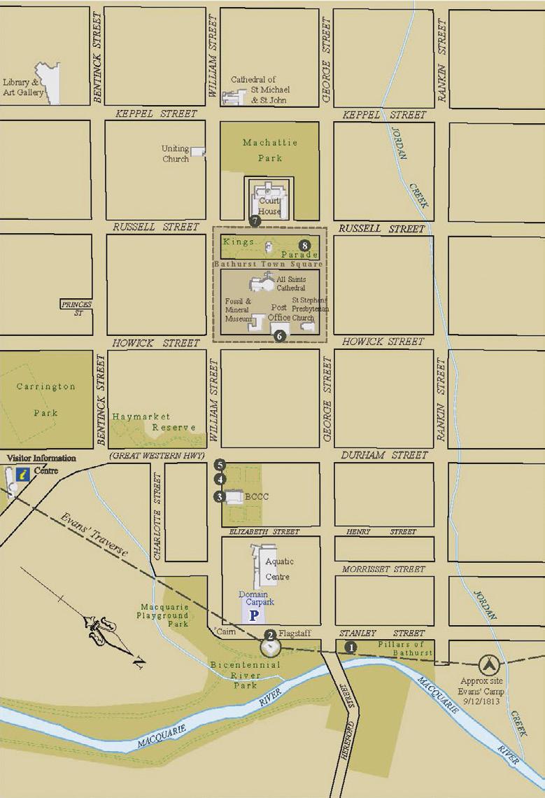
2 The Surveyors Walk will take you along the Wambool/Macquarie River to historic William Street and then on to King s Parade. Along the way, you will be told the story of government surveyors, who in the early 19th century explored and surveyed the inland, opening the way for today s roads, farms and towns. You will be retracing the footsteps of these pioneering surveyors on this walk. You will also be in the footsteps of the Wiradjuri people, who for countless generations have known the same country through a traditional familiarity.
3
4 Our walk begins at the Commemorative Pillar for George Evans campsite, which will be found on the riverbank between George Street and The Pillars of Bathurst (a cultural heritage garden commemorating the lives of past Bathurstians). From there follow the route shown on the map to find the numbered stops on the walk. "Footsteps in Time Commemorative Pillar The Flag Staff A Delightful Spot Display 1815 Town Corner Post Explorers Memorial Macquarie s Meridian Two Trees - Two Understandings Evans Memorial


5 FOOTSTEPS IN TIME COMMEMORATIVE PILLAR In November 1813, Surveyor George Evans was sent by Governor Macquarie to report on the country beyond the Blue Mountains. His journey brought him to a grassy plain of excellent land, which he named the Bathurst Plains. Following the river running through the plains, on 9 December Evans and his party camped on Jordan Creek, about 200 metres from the Commemorative Pillar. The Pillar is in the form of a Trig. Survey Pillar, but larger. On 22 December, on the return leg of his journey, Evans again camped in this area.


6 As you walk to the next stop, the Flag Staff, and then through the park to lower William Street, you will be following closely the traverse of Surveyor Evans in Nearby, you will find the introductory panel for A Delightful Spot, an interpretation trail through the settlement established in Look for more of these distinctive panels on your walk. The Pillars of Bathurst has a plaque for James Byrn Richards, the government surveyor who in the late 1820s undertook the first land surveys on the western side of the Macquarie River and went on in 1833 to survey the proposed town of Bathurst. Free brochures are available from the Bathurst Visitor Information Centre for A Delightful Spot settlement walk and The Pillars of Bathurst.


7 Circumferentor THE FLAG STAFF The Bicentennial Flag Staff is located on the site of the one erected by Governor Macquarie in It was there, on 7 May 1815, he announced the establishment of a town to be called Bathurst. Macquarie s Flag Staff became the inland s first gazetted location and proved essential in the work of surveyors exploring, surveying and mapping the inland. The sign panel Placing Bathurst on the map, nearby on the Stanley Street side, will tell you more about the importance of the 1815 Flag Staff in surveying history. Also look for the Permanent NSW Survey Mark, which is on the concourse near the Flag Staff. When you leave the park at the Proclamation Cairn and enter lower William Street, you will be walking along Bathurst s first street, originally a short rough track between the early settlement s first buildings. The end Gunter s chain Surveying in the early 19th century r mathematician. The principal instru post with two moveable sighting arm bearings of natural landmarks and s chain, a metal chain of 100 short wi measurement known as a chain. kit, perhaps along with some convic and versatile replacement for the c and longitude could be calculated recording compass bearings and d travelled. In 1813, George Evans m


8 of Cox s Road, the first road into the inland, ran along this track before terminating at Macquarie s Flag Staff. The road followed a line marked out by George Evans in 1813 for much of its route of 101½ miles from the Nepean River. equired the practical skills of a bushman combined with the talents of a ment used was the circumferentor, basically a compass mounted on a straight s. With its aid, the surveyor could record from the one place the relative compass urvey markers, such as the Flag Staff. Measuring distances was done with a Gunter s re links connected together by loops. Its full length of 66 feet (20.1m) was an official (An acre is ten square chains.) These were the two basic tools in the early surveyor s t helpers. The better-equipped surveyor might employ a theodolite, a more accurate ircumferentor, and, more rarely, a sextant and chronometer, with which latitude. The first surveys began with a traverse, literally a succession of walks in straight lines, istance measurements in a field book, along with observations on the country being ade the first surveying traverses in inland Australia.


9 A DELIGHTFUL SPOT DISPLAY If the Bathurst City Community Club is open, drop in to see their extensive display of maps, plans and drawings, many of which were produced by government surveyors. (Free Admission)

10 1815 TOWN CORNER POST The post is located near a corner of the town site chosen for Bathurst by Governor Macquarie in 1815, as shown on the town plan prepared by Deputy Surveyor-General James Meehan. EXPLORERS MEMORIAL Located at the corner of the bowling green, the Memorial lists explorers who between 1815 and 1836 used the Bathurst settlement as their base for their journeys into the inland. The list includes three government surveyors: Surveyor George Evans (1815), Surveyor-General John Oxley (1817), and Surveyor-General Thomas Mitchell (1836). Durham Street, which you will now cross, follows the boundary line of the Government Domain, surveyed in the first days of the settlement s establishment.

11 MACQUARIE S MERIDIAN The Meridian Flag Staff on Howick Street is exactly midway between William and George streets. As the sign alongside explains, it is located on a meridian that runs from Macquarie s Flag Staff exactly through the centre of Bathurst. King s Parade is part of the Bathurst Town Square. The Square is a key feature on the Bathurst Town Plan approved in 1833 by Surveyor- General Thomas Mitchell. The streets you have walked date from this plan, laid out by Surveyor Richards. TWO TREES TWO UNDERSTANDINGS In May-June 1815, George Evans undertook the first expedition beyond Bathurst. On this journey, Evans explored as far as where Mandagery

.")


12 Creek enters the Lachlan River. A section of the tree on which he marked his reaching this point is now in the Bathurst District Historical Museum (East Wing, Bathurst Court House, Russell Street). If you look carefully, you may be able to make out some details of what he carved into the tree. Alongside Evans tree is a traditional Wiradjuri carved tree, once used to mark a place of cultural importance. The two trees, standing side by side, offer different understandings of the landscape. (Admission Fee)


13 EVANS MEMORIAL This impressive memorial, the work of Gilbert Doble, was commissioned in 1913 to commemorate the centenary of the crossing of the Blue Mountains and the subsequent explorations by George Evans. War delayed its completion until The prominent presence of an Aboriginal man is a feature rarely found on public memorials of that time. Crouching with eyes shaded in the way of a hunter, he shares the topmost plinth with Surveyor Evans, who is standing behind him in a more conventional statue pose. Both men are gazing westward, sharing the view of the land beyond. As Evans had no Aborigines in his exploration party, the figure is not present as a guide, but as a Wiradjuri inhabitant of these lands. The Wiradjuri and the Evans party were aware of each other, but direct contact only happened once, accidentally


14 and peacefully. Occupying lower positions, two allegorical figures representing agriculture and geographical knowledge tell of the benefits brought by the explorations of Surveyor George Evans. An information panel nearby provides a detailed account of the life and accomplishments of George Evans.
15 Acknowledgements The Institution of Surveyors, NSW Inc. Office of the Surveyor General of NSW Land and Property Information Photos of circumferentor and Gunters Chain courtesy of DFSI Spatial Services (2016), Damien Bennett Portrait of Governor Macquarie courtesy of Mitchell Library, State Library of NSW Lewins Image Courtesy of State Library of NSW Special thanks to John Reed Copyright Surveyors Walk Guide Copyright 2017 Bathurst Regional Council All rights reserved. No part of this publication may be reproduced, stored, or transmitted in any form or by any means without the prior permission of Council. Disclaimer Bathurst Regional Council expressly disclaims all liability for errors or omissions of any kind whatsoever, or any loss, damage or other consequence which may arise from any person relying on information comprised in this document.
Estabrook Woods at the time of the Revolution
 Estabrook Woods at the time of the Revolution The Revolution and Estabrook Woods The North Bridge is located just a short distance south of Estabrook Woods. While there were no battles fought in the Estabrook
A UNIQUE POINT ON EARTH
 A UNIQUE POINT ON EARTH John D. HOHOL, USA Curtis SUMNER, USA Key Words: GNSS/GPS, History, Positioning SUMMARY Most people are aware of the Greenwich Meridian. Set as 0 degrees longitude, it separates
Where, on Earth, are you?
 Where, on Earth, are you? We all live on a big planet called Earth, of course. But where on Earth? And if you want to go to a different spot on Earth other than the spot you are in, how do you know which
Level 1 Geography, 2011
 91010 910100 1SUPERVISOR S Level 1 Geography, 2011 91010 Apply concepts and basic geographic skills to demonstrate understanding of a given environment 9.30 am ednesday Wednesday 2 November 2011 Credits:
What is a map? Understanding your map needs
 What is a map? A map is simply a drawing or picture of a landscape or location. Maps usually show the landscape as it would be seen from above, looking directly down. As well as showing the landscape of
About places and/or important events Landmarks Maps How the land is, hills or flat or mountain range Connected to maps World Different countries
 What do you think you know about geography? About places and/or important events Landmarks Maps How the land is, hills or flat or mountain range Connected to maps World Different countries What do you
LECTURE NOTE ENGINEERING SURVEYING
 LECTURE NOTE ENGINEERING SURVEYING LECTURE 1 Introduction: Surveying is defined as taking a general view of, by observation and measurement determining the boundaries, size, position, quantity, condition,
3 rd Grade Social Studies Pacing Guide Arkansas Frameworks
 3 rd Grade Social Studies Pacing Guide Arkansas Frameworks 1st Nine Weeks Strand1: Geography Standard 1: Physical and Spatial Students shall develop an understanding of the physical and spatial characteristics
Social Studies Curriculum Document Grade 3 Alignment with Common Core Unit 1 Student Learning Expectation
 Social Studies Curriculum Document Grade 3 Alignment with Common Core Unit 1 Student Learning Enduring Understanding: Good citizenship should be evident by observing proper etiquette of the American flag.
Navigating for Scouts A Self-teaching Guide to Navigation with Map and Compass
 Don Burgess, November 2003 Materials topographic maps Navigating for Scouts A Self-teaching Guide to Navigation with Map and Compass metric ruler orienteering compass 30 M/5 Hamilton-Burlington 41 I/13
Early College High School PreAP World Geography Summer Reading Assignment
 Early College High School PreAP World Geography Summer Reading Assignment In preparation for your studies in World Geography you will be familiarizing yourself with the 5 Themes of Geography. This assignment
name and locate the world s seven continents and five oceans
 Subject: Geography Activities National Curriculum Objectives One Progression of Skills Name the 7 continents and 5 oceans 3D Jigsaw task to locate continents and seas name and locate the world s seven
The Five Themes of Geography
 The Five Themes of Geography The Five Themes of Geography Main Idea: Geographers use the Five Themes of Geography to help them study the Earth. The Five Themes of Geography Geography and You: Suppose a
Butte County Fire Department
 Butte County Fire Department Basic Land Navigation Verification Sheet I verify that Print Supervisor s name has completed the Print Employee s name Basic Land Navigation self study guide on. Date Attached
ORIENTEERING. The challenge is to use the map to decide the best route to complete the course in the quickest time. Orienteering Map. Compass.
 ORIENTEERING Orienteering is similar to a cross-country race but you navigate using a map instead of following a set course. It is an outdoor sport where competitors navigate their own way, you can run,
Unit 1 Part 2. Concepts Underlying The Geographic Perspective
 Unit 1 Part 2 Concepts Underlying The Geographic Perspective Unit Expectations 1.B Enduring Understanding: Students will be able to.. Know that Geography offers asset of concepts, skills, and tools that
In order to be adequately prepared for a test on this topic you should be able to:-
 Topic 2: MAPPING In order to be adequately prepared for a test on this topic you should be able to:- 1. Find and also provide both FOUR and SIX figure Area and Grid References 2. Calculate distances both
Using Map and Compass Together
 Using Map and Compass Together In situations where you foresee a potential evacuation on foot, where there are no roads, and no indication as to the direction of travel (i.e., road signs), it is recommended
Cranford Park CE Primary School. Subject Overview for Geography. Autumn 1 Autumn 2 Spring 1 Spring 2 Summer 1 Summer 2 Title of unit.
 Autumn 1 Autumn 2 Spring 1 Spring 2 Summer 1 Summer 2 Main Objectives /Skills Main Objectives /Skills Main Objectives /Skills Main Objectives /Skills Main Objectives /Skills Main Objectives /Skills Foundation
Your web browser (Safari 7) is out of date. For more security, comfort and the best experience on this site: Update your browser Ignore
 is out of date. For more security, comfort and the best experience on this site: Update your browser Ignore") Your web browser (Safari 7) is out of date. For more security, comfort and the best experience on this site: Update your browser Ignore GIS ( GEO GRAPHIC INFO RMATIO N SYSTEM) geospatial information system
Your web browser (Safari 7) is out of date. For more security, comfort and the best experience on this site: Update your browser Ignore GIS ( GEO GRAPHIC INFO RMATIO N SYSTEM) geospatial information system
St John s Catholic Primary School. Geography Policy. Mission Statement
 St John s Catholic Primary School Geography Policy Mission Statement We at St John s strive for excellence in education by providing a safe, secure and caring family environment where individuals are valued
ST AMBROSE CATHOLIC PRIMARY SCHOOL Geography Policy
 ST AMBROSE CATHOLIC PRIMARY SCHOOL Geography Policy 2017-2018 Our school policy is developed in accordance with the National Curriculum for Geography and Foundation Stage Curriculum for Understanding of
Nursery. Reception. Year 1
 Nursery Geography Overview Autumn Spring Summer Notices detailed features of objects in their environment. Comments and asks questions about aspects of their familiar world such as the place where they
Map reading made easy
 Map reading made easy 1 1. What is a map? A map is simply a drawing or picture (in 2-D) of a landscape or area of a country (in 3-D). It could be anything from a sketch map for a visitor to find your school
Social Studies Grade 2 - Building a Society
 Social Studies Grade 2 - Building a Society Description The second grade curriculum provides students with a broad view of the political units around them, specifically their town, state, and country.
Scout Skills Mapping QUALITY TRAINING FOR QUALITY SCOUTING INFORMATION SHEET
 Scout Skills Mapping INFORMATION SHEET A map is a picture of a given area of what the ground looks like from directly above. When undertaking a journey, we need to be able to find our way around competently,
Simple Solutions Social Studies Level 2. Level 2. Social Studies. Help Pages
 Level 2 Social Studies 147 148 adobe houses with bricks made of clay and straw ancestor a family member who lived before us appoint choose; leaders can appoint others barter trading one thing for another
Surveying I. Unit - I. Different methods and instruments are being used to facilitate the work of
 Surveying I Unit - I Definition of Survey Surveying is the art of determining the relative positions of different objects on the surface of the earth by measuring the horizontal distances between them,
Map reading made easy
 Map reading made easy 1. What is a map? A map is simply a drawing or picture (in 2-D) of a landscape or area of a country (in 3-D). It could be anything from a sketch map for a visitor to find your school
Guide to the Hales Bar Dam Collection
 Guide to the Cara Whiting 2011 Archives Center, National Museum of American History P.O. Box 37012 Suite 1100, MRC 601 Washington, D.C. 20013-7012 archivescenter@si.edu http://americanhistory.si.edu/archives
56H. This system allows definition of points on the Earth s surface to within 100 meters. Page 20. Navigation Systems Basics of Maps
 Grid References Many maps are provided with the standard grid overlaying them. This provides a simple and accurate method for finding features on the map. It is a network of intersecting parallel lines
Surveying Prof. Bharat Lohani Department of Civil Engineering Indian Institute of Technology, Kanpur. Module - 4 Lecture - 1 Compass Surveying
 Surveying Prof. Bharat Lohani Department of Civil Engineering Indian Institute of Technology, Kanpur Module - 4 Lecture - 1 Compass Surveying Welcome to this video lecture series on basic surveying and
Map reading made easy
 Map reading made easy Maps can be great fun and they can lead you to all sorts of discoveries. They can help you get to know an area really well, because they pinpoint interesting places that are often
APPENDIX A GLOSSARY. Appendix A.1
 APPENDIX A GLOSSARY Appendix A.1 Appendix A.2 Back Bearing A back bearing is measured from the object to your position. It is the exact opposite of a direct bearing. Base Line An imaginary line on the
Factors that Shape Places (Blacktown) Stage 3 Geography
 Stage 3 Geography") Factors that Shape Places (Blacktown) Stage 3 Geography Summary This unit is written for Stage 3 "Factors that shape places". It is a Geographical Inquiry, enabling students to work through the 3 stages
Factors that Shape Places (Blacktown) Stage 3 Geography Summary This unit is written for Stage 3 "Factors that shape places". It is a Geographical Inquiry, enabling students to work through the 3 stages
Why Geography Matters
 Why Geography Matters Vocabulary words geography relative location absolute location physical feature human feature region modify adapt cause effect geography: The study of the Earth s physical and human
The Old Curiosity Shop
 MACMILLAN READERS INTERMEDIATE LEVEL CHARLES DICKENS The Old Curiosity Shop Retold by Helen Holwill MACMILLAN Contents A Note About The Author 4 A Note About The Story 5 The People In The Story 7 1 The
GRID REFERENCES. Grid references are always given as a 6-digit number, the first three digits represent the easting and the second three the northing.
 ESSENTIAL MATHEMATICS 4 WEEK 14 NOTES TERM 4 GRID REFERENCES The latitude/longitude system can become unwieldy when we are working in a small area particularly on land. A system was developed to cope with
GPS Measurement Protocol
 GPS Measurement Protocol Purpose To determine the latitude, longitude, and elevation of your school and of all your GLOBE sites Overview The GPS receiver will be used to determine the latitude, longitude
Public Land Survey System Knowledge Remains an Important Skill
 By Douglas S. Helmke, P.G., Water Rights / Source Water Specialist Public Land Survey System Knowledge Remains an Important Skill In our new world of global positioning system (GPS) navigation, with digital
Map and Compass Skills
 Map and Compass Skills Grade levels: 5-12 In a Nutshell Given a map and compass, students will be able to find a location on the map, chart a course to that location with the compass, and find that location
Traveling the Past into the Present The Regon's Highways & Byways
 Periodic Atlas of the Traveling the Past into the Present The Regon's Highways & Byways David Peterson del Mar, Historian Heather Kaplinger, Cartographer Meg Merrick, Atlas Concept Few of the overland
Topographic Map Series:
 DEFINITION OF A MAP A MAP IS A GEOGRAPHIC PREPRESENTATION OF A PORTION OF THE EARTH S SURFACE DRAWN TO SCALE, AS SEEN FROM ABOVE. IT S USES COLORS, SYMBOLS AND LABELS TO REPRESENT FEATURES FOUND ON THE
Earth Science Regents Reading Topographic Maps
 Earth Science Regents Reading Topographic Maps Name Period Quick Tutorial on Degrees, Minutes, and Seconds of Latitude and Longitude A degree of latitude on the surface of the earth is about 70 miles long.
Level 1 Geography, 2013
 91010 910100 1SUPERVISOR S Level 1 Geography, 2013 91010 Apply concepts and basic geographic skills to demonstrate understanding of a given environment 9.30 am Friday 22 November 2013 Credits: Four Achievement
Test Booklet. Subject: LA, Grade: NECAP Grade 6 Reading. Student name:
 Test Booklet Subject: LA, Grade: 06 2007 NECAP Grade 6 Reading Student name: Author: Rhode Island District: Rhode Island Released Tests Printed: Tuesday September 11, 2012 1 We knew the fish was fresh
MEADOWS PRIMARY SCHOOL and NURSERY GEOGRAPHY POLICY
 MEADOWS PRIMARY SCHOOL and NURSERY GEOGRAPHY POLICY Purpose of study The teaching of Geography at Meadows is done by following the 2014 National Curriculum. The planning and teaching of the subject aims
Ganado Unified School District (Social Studies/1 st Grade)
") Ganado Unified School District (/1 st Grade) PACING Guide SY 2016-17 1 st Quarter (11 Performance Objectives) Strand 1: American History, Strand 2: World History, Strand 3: Civics/Government, Strand 4:
Ganado Unified School District (/1 st Grade) PACING Guide SY 2016-17 1 st Quarter (11 Performance Objectives) Strand 1: American History, Strand 2: World History, Strand 3: Civics/Government, Strand 4:
Warren County Schools Primary Social Studies Curriculum
 P2 Government and Civics SS-P-GC-U-1 Students will understand that local governments are formed to establish order, provide security and accomplish common goals. SS-P-GC-U-2 Students will understand that
GRADE 6 GEOGRAPHY TERM 1 LATITUDE AND LONGITUDE (degrees)
") 1 GRADE 6 GEOGRAPHY TERM 1 LATITUDE AND LONGITUDE (degrees) Contents Lines of Latitude... 2 Lines of Longitude... 3 The hemispheres of The Earth... 4 Finding countries and cities on a map using latitude
1 GRADE 6 GEOGRAPHY TERM 1 LATITUDE AND LONGITUDE (degrees) Contents Lines of Latitude... 2 Lines of Longitude... 3 The hemispheres of The Earth... 4 Finding countries and cities on a map using latitude
Unit 1: Geography. For additional information, refer to this website: 1 G e o g r a p h y
 Unit 1: Geography For additional information, refer to this website: http://mryoungtms.weebly.com/ 1 G e o g r a p h y Continents and Oceans SOL USI. 2a Essential Understanding: Continents are large land
Grade 2 Benchmarks ( )
") 2.1.1.1.1 Demonstrate voting skills, identify rules that keep a voting process fair, and explain why voting is important. Democracy Rules Fairness Values Voting -Weighing options -Making a choice How does
2.1.1.1.1 Demonstrate voting skills, identify rules that keep a voting process fair, and explain why voting is important. Democracy Rules Fairness Values Voting -Weighing options -Making a choice How does
What Is a Globe? Hemispheres. Main Idea Globes and maps provide different ways of showing features of the earth. Terms to Know
 r Main Idea Globes and maps provide different ways of showing features of the earth. Terms to Know hemisphere latitude longitude scale bar scale relief elevation contour line What Is a Globe? A globe is
of places Key stage 1 Key stage 2 describe places
 Unit 25 Geography and numbers ABOUT THE UNIT This continuous unit aims to show how geographical enquiry can provide a meaningful context for the teaching and reinforcement of many aspects of the framework
2002 HSC Notes from the Marking Centre Geography
 2002 HSC Notes from the Marking Centre Geography 2003 Copyright Board of Studies NSW for and on behalf of the Crown in right of the State of New South Wales. This document contains Material prepared by
Many Ways to Name a Place
 Your web browser (Safari 7) is out of date. For more security, comfort and Activityapply the best experience on this site: Update your browser Ignore Many Ways to Name a Place What are the names for the
Stage 2 Geography. Assessment Type 1: Fieldwork. Student Response
 Stage 2 Geography Assessment Type 1: Fieldwork Student Response Page 1 of 21 Page 2 of 21 Page 3 of 21 Image removed due to copyright. Page 4 of 21 Image removed due to copyright. Figure 5: A cause of
Grade 4 Benchmarks. Benchmark Concepts Skills Essential Question(s)
") **Be aware of the use of and & or in the benchmark language related to Canada and Mexico; sometimes students may look at the US and one of our neighboring countries and other times students need to study
**Be aware of the use of and & or in the benchmark language related to Canada and Mexico; sometimes students may look at the US and one of our neighboring countries and other times students need to study
Phase 1 Cards. Phase 1. Phase 1. How many picnic areas does the park have? Write the answer near the legend.
 S T U D E N T H A N D O U T F Cards Write the map s title in the northwest corner above the map. How many picnic areas does the park have? Write the answer near the legend. 1 2 Draw a compass rose near
Aerial Photograhy. Brief history of aerial photography
 MAPWORK TOPIC ONE Why do we use maps? Maps are very important tools for geographers because they enable them to record, display and analyse information about people and the environment around them. Maps
Geography. Programmes of study for Key Stages 1-3
 Geography Programmes of study for Key Stages 1-3 February 2013 Contents Purpose of study 3 Aims 3 Attainment targets 3 Subject content 4 Key Stage 1 4 Key Stage 2 5 Key Stage 3 6 2 Purpose of study A high-quality
Chapter 2 - Lessons 1 & 2 Studying Geography, Economics
 Chapter 2 - Lessons 1 & 2 Studying Geography, Economics How does geography influence the way people live? Why do people trade? Why do people form governments? Lesson 1 - How Does Geography Influence the
INTRODUCTION. As you look out the window, you. What Is Geography?
 fm.qxd 10/18/01 1:09 PM Page 1 INTRODUCTION What Is Geography? As you look out the window, you may see rolling hills, broad plains, mountains, a river valley, or perhaps the ocean. You also may notice
Canadian Mapping Big Book
 Canadian Mapping Big Book Grades 4-6 Written by Lynda Golletz Illustrated by S&S Learning Materials About the Author: Lynda Golletz was an elementary school teacher for thirty-three years. She is the author
Geography Mile Post 1
 Mile Post 1 Use world maps, atlases and globes to identify the UK and its countries, as well as the countries, continents and oceans studied at this key stage Key Skills IPC learning Goals 1.11 Be able
1. Define map: 2. Name and define the five concepts that guide geographers a) 3. Define cartography: MAPS 4. A map serves two purposes a)
 3. Define cartography: MAPS 4. A map serves two purposes a)") 1. Define map: 2. Name and define the five concepts that guide geographers c) d) e) 3. Define cartography: MAPS 4. A map serves two purposes 5. Give two examples of early mapmaking and its (unusual?) materials
1. Define map: 2. Name and define the five concepts that guide geographers c) d) e) 3. Define cartography: MAPS 4. A map serves two purposes 5. Give two examples of early mapmaking and its (unusual?) materials
Orienteering Maps & Map Reading Latitude and Longitude Scale
 Orienteering Maps & Map Reading A map is a two-dimensional representation of the three-dimensional world you'll be hiking in. All maps will have some basic features in common and map reading is all about
Five Themes of Geography. By PresenterMed
 Five Themes of Geography By PresenterMed Geography Geography: the study of the Earth Where are things located? Why are they there? Location Location: where a place is Cardinal Directions: North, South,
Too Close for Comfort
 Too Close for Comfort Overview South Carolina consists of urban, suburban, and rural communities. Students will utilize maps to label and describe the different land use classifications. Connection to
5 THEMES OF GEOGRAPHY ACTIVITIES/BOOKLET
 5 THEMES OF GEOGRAPHY ACTIVITIES/BOOKLET Choose two activites from each theme to complete LOCATION: 1) Using latitude and longitude lines on a world map, locate and note the following: the highest mountain
2015 Copyright Board of Studies, Teaching and Educational Standards NSW for and on behalf of the Crown in right of the State of New South Wales.
 2015 Copyright Board of Studies, Teaching and Educational Standards NSW for and on behalf of the Crown in right of the State of New South Wales. This document contains Material prepared by the Board of
OA Guide to Map & Compass - Part 1
 OA Guide to Map and Compass - Part 1 OA Guide to Map & Compass - Part 1 part of The Backpacker's Field Manual by Rick Curtis published by Random House 1998 Buy it now at Amazon.com This material is taken
Topographic Maps Lab
 Geoscience 190 Environmental Geoscience Topographic Maps Lab To represent mountain belts and landforms, geologists work extensively with maps. A very important type of map used for scientific, engineering,
Appendix I-1: Archaeological Records Search
 Appendix I-1: Archaeological Records Search South Central Coastal Information Center California State University, Fullerton Department of Anthropology MH-426 800 North State College Boulevard Fullerton,
Geography and Earth Science. Unit 5
 Geography and Earth Science Unit 5 Chapter 1 Map Skills Lesson 2 Introduction to Maps Key Terms What You Will Learn to Do Use map reading skills bar scale contrast elevation intermittent landforms legend
California: Land and People Lesson 1: Locating California
 California: Land and People Lesson 1: Locating California Hemisphere One half of the earth or another sphere Video on Hemispheres click here Relative location Where a place is compared to one or more other
The Hemet Unified School District HISTORY/SOCIAL SCIENCE Content Standards In the Classroom
 The Hemet Unified School District HISTORY/SOCIAL SCIENCE Content Standards In the Classroom By the end of fourth grade students will: Demonstrate an understanding of the physical and human geographic features
OCN 201 LAB FALL 2003 POLYNESIAN AND WESTERN NAVIGATION
 Name: OCN 201 LAB FALL 2003 POLYNESIAN AND WESTERN NAVIGATION INTRODUCTION People have been sailing the seas for thousands of years, during most of which time they relied on the sun and the stars to navigate
River Realty Services Commercial
 1 4 6 N O R T H U S 9 W, C O N G E R S, N Y 1 0 9 2 0 TA B L E O F C O N T E N T S E X E C U T I V E S U M M A RY 03 Z O N I N G 09 R EG I S T R AT I O N S 04 S U B J EC T P H OTO S 10 M A P V I E W 05
2017/03/31. Figure 9. British military graveyard at Fort Cox. Figure 10. Memorial stone. HIA: Fort Cox College Water and Sanitation Services
 2017/03/31 Figure 9. British military graveyard at Fort Cox Figure 10. Memorial stone 22 2017/03/31 Figure 11. Memorial stone Previous Studies An extensive research into the SAHRIS database resulted in
Long Term Plan What is planned for Murchison?
 Long Term Plan 2018-2028 What is planned for Murchison? 1.0 Introduction The following information provides an overview of significant projects Council has planned for the Murchison settlement in the Long
WEST FROM WASHINGTON
 SEPTEMBER 2018 WEST FROM WASHINGTON Hemisphere GNSS A visit to headquarters Thought Leader Bloomberg out of touch Flood Info Ensure it s correct West from Washington Establishing the 25th and 27th Meridians
Student Handout. Write the map s title in the northwest corner of the map. How many picnic areas does the park have? Write the answer near the legend.
 Student Handout 1F Cards Write the map s title in the northwest corner of the map. How many picnic areas does the park have? Write the answer near the legend. 1 2 Draw a compass rose near the west edge
Locate places on contemporary maps using cardinal and intermediate directions, map scales, legends, and t
 Subject Grade Level 3 Social Studies G.1.3.1 G.1.3.10 G.1.3.11 G.1.3.12 G.1.3.13 G.1.3.14 G.1.3.15 G.1.3.2 G.1.3.3 G.1.3.4 G.1.3.5 G.1.3.6 G.1.3.7 G.1.3.8 G.1.3.9 Define absolute location Describe how
Factors that Shape Places Stage 3 Geography
 Factors that Shape Places Stage 3 Geography Summary This unit is written for Stage 3 "Factors that shape places". It is a Geographical Inquiry, enabling students to work through the 3 stages of inquiry;
REVISION: MAPWORK 18 SEPTEMBER 2014
 REVISION: MAPWORK 18 SEPTEMBER 2014 Lesson Description In this lesson we revise: Various mapwork calculations Summary Relative Position Bearing is the angular (angle) distance between two points True Bearing
That gives shades all day for you and me.
 The Jungles My own little jungles I know so well Beside the old road with a story to tell; For in its borders are so many things That remind me of my travels and flings. All built with trellis painted
The Blacktown Fishing Bat
 Factors That Shape Places The Blacktown Fishing Bat As urban Sydney sprawls in all directions, the Blacktown Local Government Area is changing dramatically. This Geographical Inquiry will focus on the
NAME: DATE: Leaving Certificate GEOGRAPHY: Maps and aerial photographs. Maps and Aerial Photographs
 NAME: DATE: Leaving Certificate Geography Maps and Aerial Photographs Please see Teachers Notes for explanations, additional activities, and tips and suggestions. Learning Support Vocabulary, key terms
Texas Geography Theme (Grades 4 7)
") Texas Geography Theme (Grades 4 7) Introduction The Texas Rangers were founded more than twenty years before Texas joined the United States. While the physical geography of the state has remained largely
Texas Geography Theme (Grades 4 7) Introduction The Texas Rangers were founded more than twenty years before Texas joined the United States. While the physical geography of the state has remained largely
Map Skills Made Fun: Neighborhoods and Communities
 Map Skills Made Fun: Neighborhoods and Communities 60 Fun and Engaging Reproducibles That Teach Key Map Skills and Invite Kids to Learn About Urban, Suburban, and Rural Communities by Catherine M. Tamblyn
The Geography Curriculum at Coston Primary
 The Geography Curriculum at Coston Primary Years Year 1 Year 2 Summer We are learning about where food is farmed and in The physical features of farms. The human features of farms. The characteristics
Grade Level, Course Third Grade Social Studies PLSD Balanced Assessment Practices. Type* DOK
 Unit Guides Assessment Items Indic ator s Concept Standard Curricular Indicator DOK Type* SR CR PB Assessment Questions # DOK Level 1E 1M 1H 2E 2M 2H 3E 3M 3H Civics Students will develop and apply the
Geography Policy 2014
 Geography Policy 2014 DEFINITION Geography education should inspire in pupils a curiosity and fascination about the world and its people that will remain with them for the rest of their lives. Teaching
VCE PHYSICS. Brian Shadwick. Unit 2 What Do Experiments Reveal. About the Physical World?
 2 Unit 2 What Do Experiments Reveal About the Physical World? VCE PHYSICS Brian Shadwick 2016 Bag 7023 Marrickville SW 1475 Australia Tel: (02) 9516 1122 Fax: (02) 9550 1915 sales@sciencepress.com.au www.sciencepress.com.au
Mapping the Badlands. Surveying and GIS Just Got Easier. >> By Deral Paulk, LS
 $4.95 Mapping the Badlands Surveying and GIS Just Got Easier Surveying and mapping here in southwestern Oklahoma can be a challenge. It s a rough-hewn landscape with rugged terrain features and plenty
Chapter 2: Studying Geography, Economics, and Citizenship
 Chapter 2: Studying Geography, Economics, and Citizenship Lesson 2.1 Studying Geography I. Displaying the Earth s Surface A. A globe of the Earth best shows the sizes of continents and the shapes of landmasses
Observing Subtleties: Traditional Knowledge and Optimal Water Management of Lake St. Martin
 Observing Subtleties: Traditional Knowledge and Optimal Water Management of Lake St. Martin Myrle Traverse and Richard Baydack Abstract Lake St. Martin First Nation is an Anishinaabe community situated
Relative and Absolute Directions
 Relative and Absolute Directions Purpose Learning about latitude and longitude Developing math skills Overview Students begin by asking the simple question: Where Am I? Then they learn about the magnetic
Class 4J Spring Term Irian Jaya/Papua New Guinea Adapted from QCA Geography Unit 10 incorporating some elements of Unit 25
 Class 4J Spring Term 2003 Geography Irian Jaya/Papua New Guinea Geography Unit 10 incorporating some elements of Unit 25 ABOUT THE UNIT In this unit children develop ideas about a less economically developed