Traveling the Past into the Present The Regon's Highways & Byways
|
|
|
- Adam Johns
- 5 years ago
- Views:
Transcription


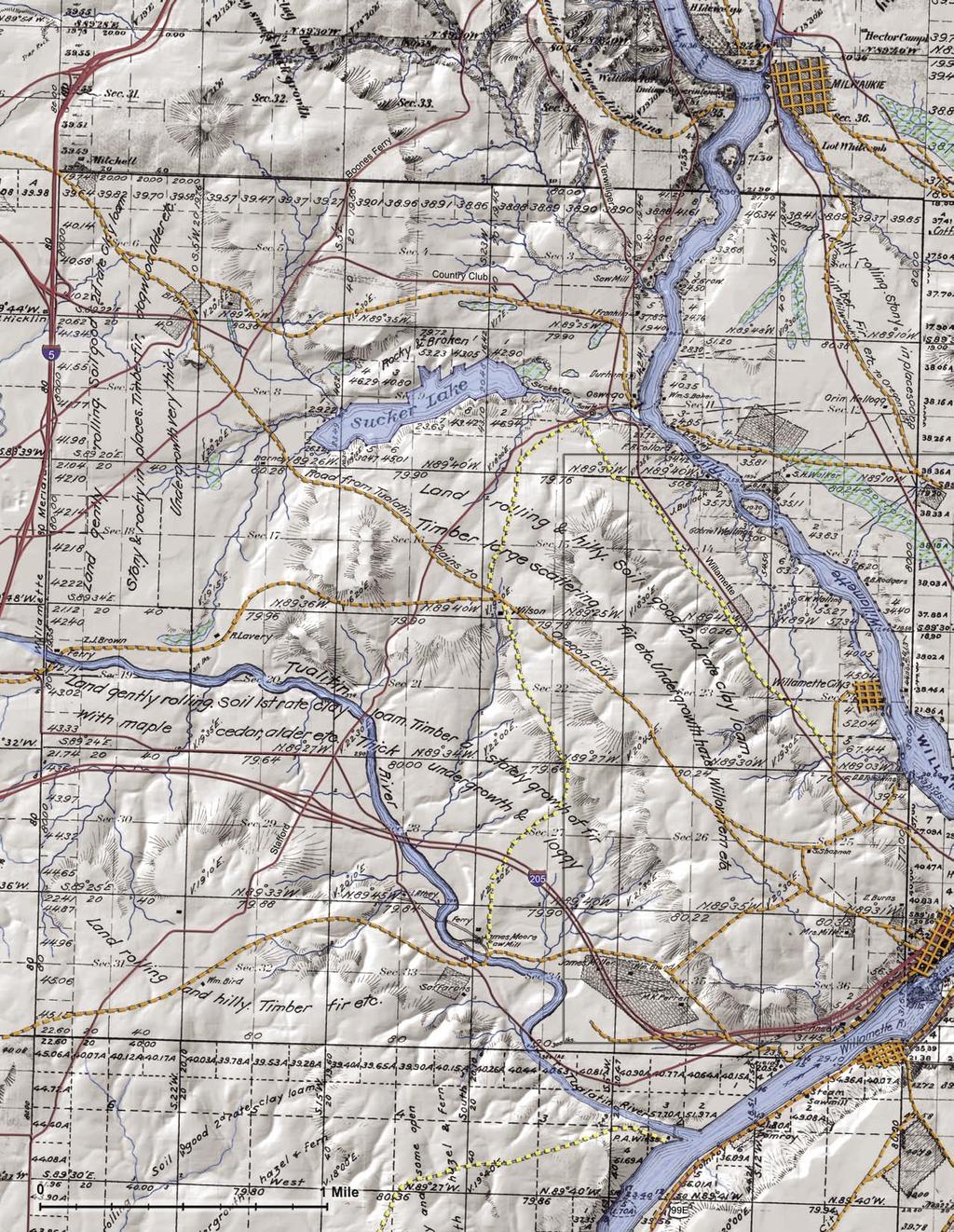
1 Periodic Atlas of the Traveling the Past into the Present The Regon's Highways & Byways David Peterson del Mar, Historian Heather Kaplinger, Cartographer Meg Merrick, Atlas Concept Few of the overland emigrants who poured into the Willamette Valley in the early 1840s were seeking gold or fame. They wanted fertile farming land as much as they could grab. That the Oregon Country was occupied by indigenous peoples and the Hudson s Bay Company and claimed by Great Britain as well as the United States did not deter them. Great Britain and the United States set the boundary well north of the Willamette Valley in But the critical question of land ownership remained until the Donation Land Law of 1850 which confirmed claims made under earlier, very generous, acts; granted 320 acres to Wilsonville, circa 1852 LEGEND* white male Oregonians over the age of eighteen and another 320 acres to their wives and allowed those settling after December 1, 1850 to claim half as much. Historians have argued that the 1850 act contributed to Oregon s conservatism. Wives could get land through the measure, but men s thirst for another 320 acres proved to be so great that Oregon women were married long before they were old enough to exercise much independence. The law made a point of excluding men of Hawaiian and African descent, a provision designed to deter dark-skinned peoples from settling here. The ample size of the grants, given the rudimentary state of Oregon farming, meant that much of the land would lie idle for another generation. In Empire of the Columbia: A History of the Pacific Northwest, Dorothy Johansen and Charles Gates argue that the outsized grants isolated the settlers, impeding the growth of towns and the diversification of occupations, industry and crops, and increasing a characteristic tendency of pioneers toward provincialism and localism. The generous Donation Land Law drew an unprecedented wave of settlers, some 20,000 from , and made imperative a quick, accurate survey of the territory s arable land. The work began late in 1850, when surveyors established a base line that ran east and west from Portland and a meridian running south from the Willamette River s mouth. The survey took many years to complete, but soon established a precise grid across most of the Willamette Valley, which then, as now, held the great majority of Oregon s residents. The survey s principal goals had to do with land tenure: it was to both record the precise nature of existing claims and to map accurately the lines upon which new ones would be made. Indeed, new claimants had to make rectangular claims. Hence one can often distinguish earlier claims by their diagonal and irregular borders. But the surveyors did more than impose an imaginary grid on Oregon s bountiful soils. They also recorded features of the actual, seen landscape rivers, lakes, hills, and mountains, of course, but also soil types, timber, and marshland. They marked the ways in which settlers and Indians had marked the land with trails, roads, buildings, fields, and other features. Historical geographers professional and amateur have barely begun to mine this remarkably detailed source. Superimposed on recent maps of the Portland area, as presented here, one can see, literally, the ways in which modern arteries like Foster Road and Sandy Boulevard follow much earlier and rudimentary transportation routes, or how some streams and marshes have disappeared as others, such as Sucker Lake, both grew and assumed new names (Lake Oswego). The pioneering surveyors who tramped their way across fields, swamps, and hills did much more than help to settle Oregon. They left us a remarkably precise visual record of the land before a series of economic and social transformations would rework it, even as it intimates how that pre-modern landscape would shape the changes to come. *This legend applies to all of the maps in this atlas. Map Sources: Map and Aerial Photography Collection Digital Copies of the Cadastral Survey Maps for Oregon, produced by the General Land Office in the 19th and 20th centuries. These are large JPEG images in.zip files (1-2.5MB). Page 13

2 Portland Area, 2001 Page 14

3 Portland Area, circa 1852 Page 15
4 Page 16

5 Milwaukie, Lake Oswego, and Oregon City, circa 1852 Page 17


6 Portland Area Topo Property, circa 1852 Page 18


7 Oregon City, 2001 Oregon City Property, circa 1852 M Page 19
Learning Target : Describe the purposes and uses of different types of maps.
 Learning Target : Describe the purposes and uses of different types of maps. Directions: 1. Below, place a where you think you are located. 2. In which continent are you located? 3. In which country are
Unit 1: Geography. For additional information, refer to this website: 1 G e o g r a p h y
 Unit 1: Geography For additional information, refer to this website: http://mryoungtms.weebly.com/ 1 G e o g r a p h y Continents and Oceans SOL USI. 2a Essential Understanding: Continents are large land
5th social studies geography (5thsocstud_geography)
") Name: Date: 1. Many of the Native Americans who lived on the Great Plains were nomadic people. Why did they move from place to place? A. They were finding new areas to mine. B. They were looking for fertile
Name: Date: 1. Many of the Native Americans who lived on the Great Plains were nomadic people. Why did they move from place to place? A. They were finding new areas to mine. B. They were looking for fertile
Canadian Mapping Big Book
 Canadian Mapping Big Book Grades 4-6 Written by Lynda Golletz Illustrated by S&S Learning Materials About the Author: Lynda Golletz was an elementary school teacher for thirty-three years. She is the author
4 th Grade Virginia Studies SOL Review Packet Geography of Virginia. 1. The Algonquian language group of Indians lived in what region of Virginia?
 4 th Grade Virginia Studies SOL Review Packet Geography of Virginia 1. The Algonquian language group of Indians lived in what region of Virginia? A. Allegheny B. Piedmont C. Ridge and Valley D. Tidewater
Critical Thinking. about. GeoGRAPHY. United States, Canada, and Greenland. Jayne Freeman
 Critical Thinking about GeoGRAPHY United States, Canada, and Greenland Jayne Freeman WALCH EDUCATION Contents Introduction............................................................... v National Geography
Geography involves the study of places: their locations, their characteristics, and how humans use and move around them.
 Physical Geography Looking at the Earth Geography involves the study of places: their locations, their characteristics, and how humans use and move around them. NEXT Physical Geography Looking at the Earth
About places and/or important events Landmarks Maps How the land is, hills or flat or mountain range Connected to maps World Different countries
 What do you think you know about geography? About places and/or important events Landmarks Maps How the land is, hills or flat or mountain range Connected to maps World Different countries What do you
Different types of maps and how to read them.
 Different types of maps and how to read them. A map is a picture or representation of the Earth's surface, showing how things are related to each other by distance, direction, and size. Maps have been
Ancient China UNIT 4 GEOGRAPHY CHALLENGE. 1 Unit 4 Geography Challenge. Teachers Curriculum Institute
 UNIT 4 GEOGRAPHY CHALLENGE Ancient China N W E S 0 250 500 miles 0 250 500 kilometers Albers Conic Equal-Area Projection AW_ISN_U04_01 Ancient China Second Proof TCI18 108 1 Unit 4 Geography Challenge
Complete Geography Overview: Year 1 to Year 6
 Option 1 Complete Geography Overview: Year 1 to Year 6 Autumn Term Spring Term Summer Term Year 1 Where do I live? Around the World The Four Seasons Year 2 At the Farm Let s go on Safari My World and Me
Simple Solutions Social Studies Level 2. Level 2. Social Studies. Help Pages
 Level 2 Social Studies 147 148 adobe houses with bricks made of clay and straw ancestor a family member who lived before us appoint choose; leaders can appoint others barter trading one thing for another
Content Area: Social Studies Standard: 1. History Prepared Graduates: Develop an understanding of how people view, construct, and interpret history
 Standard: 1. History Develop an understanding of how people view, construct, and interpret history 1. Organize and sequence events to understand the concepts of chronology and cause and effect in the history
data becomes available to us. We already have crude maps of the Mars and the Moon. A map gives a picture of one or several of the elements of the
 FUNDAMENTALS OF MAPS THE SPHERICAL earth is best represented bya three-dimensional model of the earth, called a globe. All parts of the earth can be shown on it in their true shape, area and location along
MAPS AND THEIR CLASSIFICATION
 MAPPING MAPS AND THEIR CLASSIFICATION WHAT IS A MAP? A map is representation of the Earth's surface, showing how things are related to each other by distance, direction, and size. Maps are a way of showing
Geography Long Term Plan 2018
 Geography Long Term Plan 2018 Geography Co-ordinator: Megan Frost A high-quality geography education should inspire in pupils a curiosity and fascination about the world and its people that will remain
Chapter 6, Part Colonizers arriving in North America found extremely landscapes. It looked different to region showing great.
 Social Studies 9 Unit 1 Worksheet Chapter 6, Part 1. 1. Colonizers arriving in North America found extremely landscapes. It looked different to region showing great. 2. The Earth is years old and is composed
Factors Affecting Human Settlement
 Factors Affecting Human Settlement Physical Factors One of the most basic factors affecting settlement patterns is the physical geography of the land. Climate is key, because if a place is too dry, too
How Geographers View the World: Human Geography. ESSENTIAL QUESTION: How does geography influence the way people live?
 How Geographers View the World: Human Geography ESSENTIAL QUESTION: How does geography influence the way people live? Geographers Think Spatially Gefffffdgfhfjgjp Guiding Question: What does it mean to
Class 4J Spring Term Irian Jaya/Papua New Guinea Adapted from QCA Geography Unit 10 incorporating some elements of Unit 25
 Class 4J Spring Term 2003 Geography Irian Jaya/Papua New Guinea Geography Unit 10 incorporating some elements of Unit 25 ABOUT THE UNIT In this unit children develop ideas about a less economically developed
Your web browser (Safari 7) is out of date. For more security, comfort and. the best experience on this site: Update your browser Ignore
 is out of date. For more security, comfort and. the best experience on this site: Update your browser Ignore") Your web browser (Safari 7) is out of date. For more security, comfort and Activityengage the best experience on this site: Update your browser Ignore Comparing Historical Maps How can historical maps
Your web browser (Safari 7) is out of date. For more security, comfort and Activityengage the best experience on this site: Update your browser Ignore Comparing Historical Maps How can historical maps
Ancient China. Teachers Curriculum Institute Geography and the Early Settlement of China 1. AW_ISN_U04_01 Ancient China Second Proof TCI18 108
 G e o g r a p h y C h a l l e n g e Ancient China N W E S 0 250 500 miles 0 250 500 kilometers Albers Conic Equal-Area Projection AW_ISN_U04_01 Ancient China Second Proof TCI18 108 Teachers Curriculum
Class 4J Autumn Term St. Lucia Adapted from QCA Geography Unit 10 incorporating some elements of Unit 25
 Class 4J Autumn Term 2002 Geography St. Lucia Geography Unit 10 incorporating some elements of Unit 25 ABOUT THE UNIT In this unit children develop ideas about a less economically developed country. When
Geography and the Early Settlement of China
 Geography and the Early Settlement of I N T E R A C T I V E S T U D E N T N O T E B O O K How did geography affect life in ancient? P R E V I E W Physical Features 1. Circle the physical features that
Wednesday, May 23, 2018
 Wednesday, May 23, 2018 Physical Geography of West Africa Objective: Summarize the main geographic aspects of each country in West Africa. Understand each country s development pattern and their current
CHAPTER 1: EXPLORING GEOGRAPHY
 CHAPTER 1: EXPLORING GEOGRAPHY Please Do Now: In your PDN section of your binder answer the following with one or two sentences: What is Geography? What is Geography? The study of where people, places,
New National Curriculum Geography Skills Planning KS1
 New National Curriculum Geography Skills Planning KS1 Enquiry Question Objective-essential knowledge skills or understanding Locational Knowledge Standards /Success Criteria Lesson progression over half
Map Skills Test. 1. What do we call a person who makes maps? a. mapographer b. cartographer c. geologist d. archaeologist
 Map Skills Test 1. What do we call a person who makes maps? a. mapographer b. cartographer c. geologist d. archaeologist 2. What is the name of the 0 latitude line? a. Equator b. Arctic Circle c. First
HIST1301 Dr. Butler MAP EXERCISE THREE
 HIST1301 Dr. Butler MAP EXERCISE THREE Instructions: For this exercise, students will examine a variety of maps relating to the Early National Period. Links to these maps are provided on the professor
STUDY GUIDE. Exploring Geography. Chapter 1, Section 1. Terms to Know DRAWING FROM EXPERIENCE ORGANIZING YOUR THOUGHTS
 For use with textbook pages 19 22. Exploring Geography Terms to Know location A specific place on the earth (page 20) absolute location The exact spot at which a place is found on the globe (page 20) hemisphere
LATITUDE. Latitude lines run to, but are measured & The 0 of latitude that circles the earth is called the?
 LATITUDE Latitude lines run to, but are measured & The 0 of latitude that circles the earth is called the? LATITUDE 0 0 Latitude lines run east to west, but are measured north & south The 0 of latitude
Word Cards. 2 map. 1 geographic representation. a description or portrayal of the Earth or parts of the Earth. a visual representation of an area
 Name: Date: Hour: Word Cards 1 geographic representation a description or portrayal of the Earth or parts of the Earth Example: A map is a representation of an actual location or place. 2 map a visual
Norwich City Schools Social Studies 6
 Social Studies 6 Topic: Maps and Globes and Graphs and Time Transferable Concepts: change 3: Geography Geography Geographers use maps, globes, and graphs to study the Earth and everything on it. Types
Geography Mile Post 1
 Mile Post 1 Use world maps, atlases and globes to identify the UK and its countries, as well as the countries, continents and oceans studied at this key stage Key Skills IPC learning Goals 1.11 Be able
NATIONAL CURRICULUM GEOGRAPHY PLANNING OVERVIEW
 GEOGRAPHY AUTUMN TERM SPRING TERM SUMMER TERM Year 1 Hunting and Hiding Me and My Wonderful World Beside The Sea identify seasonal and daily weather patterns in the United Kingdom and the location of hot
Unit 9.2 Introduction to Geography
 Unit 9.2 Introduction to Geography Name: Period: This activity has been modified from the Stanford History Education Group from the original found here. 1 What does it mean to think like a geographer?
APPENDIX 1 LITTLE EGYPT FROM THE AIR
 APPENDIX 1 LITTLE EGYPT FROM THE AIR FIGURE 1. In this 1930 City of Dallas aerial photo, the land surrounding Little Egypt is seen as cultivated fields and agricultural structures. The Hill property is
Too Close for Comfort
 Too Close for Comfort Overview South Carolina consists of urban, suburban, and rural communities. Students will utilize maps to label and describe the different land use classifications. Connection to
PROSPECTING REPORT TENURES # / / CLAIM NAMES OLD SETTLER; OLD SETTLER1; OLD SETTLER2
 2011 PROSPECTING REPORT EVENT - 5160426 TENURES # 688183 / 691903 / 691905 CLAIM NAMES OLD SETTLER; OLD SETTLER1; OLD SETTLER2 COAST CRYSTALINE BELT REGION NEW WESTMINSTER MINING DISTRICT MAP - 092H GPS
Map Skills Unit. Note taking unit
 Map Skills Unit Note taking unit Introduction To learn about the Earth, we are going to learn about two geographic tools you can use.globes and maps. Globe A globe is a round model of the planet Earth
Unit 1: Geography CLASS WEBSITE: QUIZLET GAMES: ONLINE RESOURCES
 Unit 1: Geography ONLINE RESOURCES CLASS WEBSITE: HTTPS://MRYOUNGTMS.WEEBLY.COM/GEOGRAPHY.HTML QUIZLET GAMES: HTTPS://QUIZLET.COM/JOIN/MSFYY94T5 1 G e o g r a p h y Continents and Oceans The Seven Continents
The map document opens, and you see a physical map of the world with the Saudi Arabian Peninsula outlined in red.
 Module 5, Lesson 2 A line in the sand The ever-changing map of the world reflects the forces of conflict and cooperation among nations and peoples of the world. In this activity, you will explore one of
Parts of a Map. Map Skills. The Title. There are 4 main parts of a map: The Title The Compass Rose The Map Key The Scale
 Map Skills Parts of a Map There are 4 main parts of a map: The Title The Compass Rose The Map Key The Scale The Title The title of the map is usually at the top and describes the topic of the map Example:
Use of Government Land Office Surveys in Tribal GIS Land Management. Dustin Holt GIS Technician Choctaw Nation of Oklahoma
 Use of Government Land Office Surveys in Tribal GIS Land Management Dustin Holt GIS Technician Choctaw Nation of Oklahoma Ardmore Quadrangle - 1949 Different versions of the same map were printed in 1901,
Globes, Maps, and Atlases. Plus, A Whole Bunch of Other Way Cool Geographic Information!!!
 Globes, Maps, and Atlases Plus, A Whole Bunch of Other Way Cool Geographic Information!!! Globes Are the Most Accurate Portrayal of the Earth The earth is about 24,900 miles in circumference, and about
AS 410 Land Navigation. Chpt 4-1
 AS 410 Land Navigation Chpt 4-1 Overview Types of Maps Map Legends / Scales Latitude and Longitude Orienteering Why? Why important to learn how to read a compass and map? No cell phone coverage Mountain
Why Do We Live Here? : A Historical Geographical Study of La Tabatiere, Quebec North Shore
 Why Do We Live Here? : A Historical Geographical Study of La Tabatiere, Quebec North Shore Lesson Overview Many communities and their occupants have historical connections to exploration routes and traditional
Geography Progression
 Geography Progression This document aims to track expectations for History within George Grenville Academy. What the National Curriculum says: KS1: Locational Knowledge: Name and locate the world s 7 continents
Chapter 27. Bhutan, Maldives, Nepal, & Sri Lanka
 Chapter 27 Bhutan, Maldives, Nepal, & Sri Lanka Physical Geography of Bhutan, Maldives, Nepal & Sri Lanka Landforms Their locations on the fringe of South Asia means their physical and human geography
MEADOWS PRIMARY SCHOOL and NURSERY GEOGRAPHY POLICY
 MEADOWS PRIMARY SCHOOL and NURSERY GEOGRAPHY POLICY Purpose of study The teaching of Geography at Meadows is done by following the 2014 National Curriculum. The planning and teaching of the subject aims
Milford Public Schools Curriculum
 Milford Public Schools Curriculum Department: Social Studies Grade 3 Course Name: Communities Course Description In third grade, students will engage in a yearlong study of communities and specifically
MAP STUDY: INTERPRETATION OF SURVEY MAPS
 MAP STUDY: INTERPRETATION OF SURVEY MAPS Types and Elements of Maps Maps are drawn to represent the Earth on a piece of paper. Maps are used widely to represent the Earth. Maps use signs and symbols in
GEOGRAPHY POLICY STATEMENT. The study of geography helps our pupils to make sense of the world around them.
 GEOGRAPHY POLICY STATEMENT We believe that the study of geography is concerned with people, place, space and the environment and explores the relationships between the earth and its peoples. The study
Children needing support to achieve key skills. Children surpassing key skills. Geography Progression in Skills Key Stage One. Locational Knowledge
 Skills Locational Knowledge Geography Progression in Skills Key Stage One Children needing support to achieve key skills Children surpassing key skills To understand that the world extends outside their
B. Topographic maps are also called. contour maps
 Topographic Maps Introduction A. Topographic maps are essential tools in geologic and engineering studies because they show the configuration of Earth's surface in remarkable detail and permit one to measure
Techniques for Science Teachers: Using GIS in Science Classrooms.
 Techniques for Science Teachers: Using GIS in Science Classrooms. After ESRI, 2008 GIS A Geographic Information System A collection of computer hardware, software, and geographic data used together for
Geography Policy. Introduction
 Geography Policy Introduction Geography at St. Aloysius Federation School teaches an understanding of places and environments and aims to inspire a curiosity and fascination about the world and its people.
Texas Geography. Understanding the physical and human characteristics of our state
 Texas Geography Understanding the physical and human characteristics of our state To understand Texas you must first learn about its Geography. Geography- The study of the world, its people, and the interaction
Chapter 27. Bhutan, Maldives, Nepal, & Sri Lanka
 Chapter 27 Bhutan, Maldives, Nepal, & Sri Lanka Physical Geography of Bhutan, Maldives, Nepal & Sri Lanka Landforms Their locations on the fringe of South Asia means their physical and human geography
Tuition, Medical and Behaviour Support Service
 Tuition, Medical and Behaviour Support Service Curriculum Policy - Primary Geography Reviewed: October 2018 Next Review: October 2019 Responsibility: Andrea Snow AIMS AND PRINCIPLES The national curriculum
Unit 1 Part 2. Concepts Underlying The Geographic Perspective
 Unit 1 Part 2 Concepts Underlying The Geographic Perspective Unit Expectations 1.B Enduring Understanding: Students will be able to.. Know that Geography offers asset of concepts, skills, and tools that
Social Studies: Grade 4. Table of Contents
 Social Studies: Grade 4 Table of Contents Heritage and Citizenship Medieval Times Overview --------------------------- Page 1 Overall Expectations --------------------------- Page 1 Specific Expectations
 estrandh@uoregon.edu Introduction The general topic of this paper describes a unique cartographic project depicting a mountain landscape for the Friends of Opal Creek (F.O.C.), a non-profit organization.
Lab Topographic Maps. Name: Partner: Purpose. Background Information
 Lab Topographic Maps Name: Partner: Purpose The purpose of this lab is to familiarize you with graphic representations of the Earth s surface primarily maps. Simple line maps show the spatial relationship
Developing Spatial Awareness :-
 Developing Spatial Awareness :- We begin to exercise our geographic skill by examining he types of objects and features we encounter. Four different spatial objects in the real world: Point, Line, Areas
Saskatchewan s Early Trade Routes: The Impact of Geography on Trade
 Saskatchewan s Early Trade Routes: The Impact of Geography on Trade Lesson Overview In this lesson, students will compare and contrast prehistoric First Nations trade routes and trade goods with the routes
Unit 1: Basics of Geography Test Review
 Name Date Period Unit 1: Basics of Geography Test Review Directions: Reading the following sections and complete the questions, charts, and diagrams. Types of Maps Maps that have a particular theme are
Year 1 name and locate the four countries and capital cities of the United Kingdom and its surrounding seas
 Long Term Objective Organisation for Geography Please note that only statutory requirements should be included in this document; any supplementary guidance and information should be retained by Subject
What is the name of the continent that is labeled #1 on the map?
 What is the name of the continent that is labeled #1 on the map? North America What is the name of the continent that is labeled #2 on the map? South America What is the name of the continent that is labeled
How Irrigation Affected the Geography of Northeast Oregon
 Delia Wallis How Irrigation Affected the Geography of Northeast Oregon Grade Levels: 4 (with ability to move up or down) Time: two x 45-minute sessions Overview: Students are going to study topographical
Introduction to Mapping
 Introduction to Mapping The Purpose of Maps A representation of a region of earth or heavens Informs the reader utilizing pictures Simple to read and interpret Aids in navigation 1 Earthquake Map Provides
Unit 1 The Basics of Geography. Chapter 1 The Five Themes of Geography Page 5
 Unit 1 The Basics of Geography Chapter 1 The Five Themes of Geography Page 5 Geography comes from the Greek word geographia, which means to describe the earth. Geography is the study of the distribution
CADASTRAL DELIMITATION OF ADMINISTRATIVE TERRITORY IN ROMANIA IN ORDER TO ACHIEVE GENERAL URBAN PLANS
 CADASTRAL DELIMITATION OF ADMINISTRATIVE TERRITORY IN ROMANIA IN ORDER TO ACHIEVE GENERAL URBAN PLANS Lecturer PhD. eng. MAGDOLNA EVA KONCSAG, 1 Decembrie 1918 University of Alba Iulia, Romania ABSTRACT.
Geography Skills Progression. Eden Park Primary School Academy
 Geography Skills Progression Eden Park Primary School Academy In order to ensure broad and balanced coverage, we follow these principles: Within each phase, geography is a driver for at least 3 Learning
Mapping Diversity in Old and New Netherland
 Your web browser (Safari 7) is out of date. For more security, comfort and Activityengage the best experience on this site: Update your browser Ignore Mapping Diversity in Old and New Netherland How did
What Do You See? FOR 274: Forest Measurements and Inventory. Area Determination: Frequency and Cover
 What Do You See? Message of the Day: Many options exist to determine the size, area, or extent of a feature on a landscape FOR 274: Forest Measurements and Inventory Lecture 7: Measures of Land Area Frequency
Give 4 advantages of using ICT in the collection of data. Give. Give 4 disadvantages in the use of ICT in the collection of data
 Give 4 advantages of using ICT in the collection of data can use a handheld GPS to get accurate location information which can be used to show data linked to specific locations within a GIS can collect
UNITED NATIONS E/CONF.96/CRP. 5
 UNITED NATIONS E/CONF.96/CRP. 5 ECONOMIC AND SOCIAL COUNCIL Eighth United Nations Regional Cartographic Conference for the Americas New York, 27 June -1 July 2005 Item 5 of the provisional agenda* COUNTRY
St Joseph s R.C. Primary School. Policy for Geography
 St Joseph s R.C. Primary School Policy for Geography 2016-2017 This policy is written with consideration to our school commitment to the Rights of the Child and our achievement of becoming a Rights Respecting
Sec$on 1: Geography and Early China. How does China s geography affect the culture?
 Sec$on 1: Geography and Early China How does China s geography affect the culture? Con$nents of the World Label the continents. Where is China located? Where is China located? In your groups, begin filling
PROSPECTING REPORT TENURES # / / CLAIM NAMES OLD SETTLER; OLD SETTLER1; OLD SETTLER2
 2010 PROSPECTING REPORT EVENT # 4820658 TENURES # 688183 / 691903 / 691905 CLAIM NAMES OLD SETTLER; OLD SETTLER1; OLD SETTLER2 COAST CRYSTALINE BELT REGION NEW WESTMINSTER MINING DISTRICT MAP - 092H GPS
Unit 1 Test - Version A
 Unit 1 Test - Version A 1. Approximately, how many degrees of longitude equal one time zone change? a. 5 b. 10 c. 15 d. 20 e. 25 2. The city of Lewisville has a population of 1,000 people living in 100
1. Origins of Geography
 II. ORIGINS AND BRANCHES OF GEOGRAPHY My Notes A. Origins of Geography Unit One 6 Before carefully examining the tools of the geographer, it would be useful to examine the origins and roots of this ancient
Terrain Units PALEOGEOGRAPHY: LANDFORM CREATION. Present Geology of NYS. Detailed Geologic Map of NYS
 NYS TOPOGRAPHY Why so? PALEOGEOGRAPHY: LANDFORM CREATION Prof. Anthony Grande AFG 014 Present Geology of NYS Detailed Geologic Map of NYS Generalized Geology Detailed Geology Hot links to the fold out
Chapter 02 Maps. Multiple Choice Questions
 Chapter 02 Maps Multiple Choice Questions 1. Every projection has some degree of distortion because A. a curved surface cannot be represented on a flat surface without distortion. B. parallels and meridians
Virginia Regions Study Guide
 Name/Number: Date: Virginia Regions Study Guide Standard VS.2a: SWBAT demonstrate knowledge of the physical geography and native peoples, past and present, of Virginia by locating Virginia and its bordering
Lesson Title: Then and Now: How Society Alters Topography and Vegetation
 Lesson Title: Then and Now: How Society Alters Topography and Vegetation Lesson Author: Rodney Collins (rwcollins@lf.k12.de.us) Lesson Description: This lesson is a comparative study in which students
APPENDIX A GLOSSARY. Appendix A.1
 APPENDIX A GLOSSARY Appendix A.1 Appendix A.2 Back Bearing A back bearing is measured from the object to your position. It is the exact opposite of a direct bearing. Base Line An imaginary line on the
The Wedding of the Rails
 The Wedding of the Rails Anne Burkhalter Gilbert Elementary School aburkhalter@lexington1.net Overview Students will learn about the Transcontinental Railroad its importance in settling the west, as well
Geography. Programmes of study for Key Stages 1-3
 Geography Programmes of study for Key Stages 1-3 February 2013 Contents Purpose of study 3 Aims 3 Attainment targets 3 Subject content 4 Key Stage 1 4 Key Stage 2 5 Key Stage 3 6 2 Purpose of study A high-quality
Global South / Global North: Africa, Asia & Latin America versus US Midwest: Retracing 1500 to the present as Environmental History
 Global South / Global North: Africa, Asia & Latin America versus US Midwest: Retracing 1500 to the present as Environmental History The habitual weakness of the American people is to assume that they have
CHAPTER 1. Geo Challenges 1A to 1D. & World Map Activity
 CHAPTER 1 Geo Challenges 1A to 1D & World Map Activity SELECT YOUR CHALLENGE World Map Activity Challenge 1A Challenge 1B Challenge 1C Challenge 1D Challenge 1A WS PG. 2 STEP #1 Label the largest continent
CHANGES IN THE STRUCTURE OF POPULATION AND HOUSING FUND BETWEEN TWO CENSUSES 1 - South Muntenia Development Region
 TERITORIAL STATISTICS CHANGES IN THE STRUCTURE OF POPULATION AND HOUSING FUND BETWEEN TWO CENSUSES 1 - South Muntenia Development Region PhD Senior Lecturer Nicu MARCU In the last decade, a series of structural
Understanding Projections
 GEOGRAPHY SKILLS 1 Understanding Projections The earth is a sphere and is best shown as a globe. For books and posters, though, the earth has to be represented as a flat object. To do this, mapmakers create
The United States & Canada. A Regional Study of Anglo America
 A Regional Study of Anglo America Landform Regions of the United States & Canada world leaders in agricultural and industrial production because of... VAST LANDS stretch from the Atlantic Ocean on the
The Hemet Unified School District HISTORY/SOCIAL SCIENCE Content Standards In the Classroom
 The Hemet Unified School District HISTORY/SOCIAL SCIENCE Content Standards In the Classroom By the end of fourth grade students will: Demonstrate an understanding of the physical and human geographic features
Mapping Earth. How are Earth s surface features measured and modeled?
 Name Mapping Earth How are Earth s surface features measured and modeled? Before You Read Before you read the chapter, think about what you know about maps Record your thoughts in the first column Pair
How we made the maps. By Chris Walker. Map US Coast Survey
 How we made the maps By Chris Walker Map 1-1856 US Coast Survey Map 2-1856 US Coast Survey registered to Open Street Map, with landmark and historical resource boundaries. We started with a map that was
PROSPECTING REPORT PLACER CLAIM - FOX 4 SIMILKAMEEN MINING DIVISION MAP - 092H GPS COORDINATE REFERENCE CENTER OF CLAIM ' 6"N, 120.
 2011 PROSPECTING REPORT PLACER CLAIM - FOX 4 TENURE #793322 EVENT #5160421 SIMILKAMEEN MINING DIVISION MAP - 092H GPS COORDINATE REFERENCE CENTER OF CLAIM 49. 24' 6"N, 120. 36* 30" W REPORT PREPARED BY
CALIFORNIA AGRICULTURAL PR OPERTIES, IN C. GALE RANCH
 CALIFORNIA AGRICULTURAL PR OPERTIES, IN C. GALE RANCH LOCATION: The Ranch is located 6 Yi miles west of the City of Davis on the northwest corner of County Roads 29A and 92E in Yolo County. SIZE: 368.64