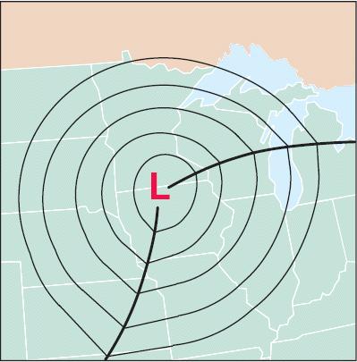
Refer to Figure 1 and what you have learned so far in this course when responding to the following:
|
|
|
- Sharyl Hubbard
- 5 years ago
- Views:
Transcription
1 Refer to Figure 1 and what you have learned so far in this course when responding to the following: 1.Looking down on a Northern Hemisphere extratropical cyclone, surface winds blow [(clockwise and outward)(counterclockwise and inward)] about the center. [ ]clockwise and outward [ ]counterclockwise and inward 2.The specific track of an extratropical cyclone s low-pressure center across Earth s surface is largely determined by large-scale horizontal winds blowing [(near Earth s surface)(in the middle and upper troposphere)]. [ ]near Earth s surface [ ]in the middle and upper troposphere 3.As a cyclone advances, the system typically progresses through a life cycle. As a cyclone develops, the central pressure of the system [(rises)(falls)] and surface winds strengthen. At maturity, clouds cover a broad area about the low center and associated precipitation is widespread. [ ]rises [ ]falls 4.In the extratropical cyclone s warm sector (the area between the warm front and the advancing cold front), surface winds are likely to be producing [(cold)(warm)] air advection. [ ]warm 5.To the north and west of the center of an extratropical cyclone, surface winds are likely to be producing [(cold)(warm)] air advection. [ ]warm 6.Dewpoints are likely to be relatively high to the [(southeast)(northwest)] of the cyclone s center. [ ]southeast west 7.As the cyclone progresses across Earth s surface, the cold and warm fronts rotate about the center of low pressure. The motion of the storm system has similarities to that of a flying Frisbee, that is, a Frisbee spins as it sails through the air (simultaneously exhibiting rotational and translational motions). Typically, the cold front rotates about the center of the low faster than the warm front. Consequently, the extent of the warm sector occupied by relatively warm and humid air at the surface [(shrinks)(increases)]. [ ]shrinks [ ]increases
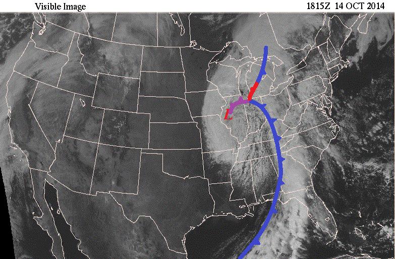
2 8.Eventually the cold front catches up with and merges with the warm front forming an occluded front. At this stage in the life cycle of an extratropical cyclone (known as occlusion), the storm often begins to weaken as the central air pressure begins to [(fall)(rise)]. [ ]fall [ ]rise 9.With the passage of a warm front, the air temperature usually rises and the dewpoint usually [(rises)(falls)]. [ ]rises [ ]falls 10.With the passage of a cold front, the air temperature usually falls and the dewpoint usually [(rises)(falls)]. [ ]rises [ ]falls 11.A shift in wind direction usually accompanies the passage of a front. With passage of the cold front, surface winds shift direction from the south to the [(southeast or east)(west or northwest)]. [ ]southeast or east [ ]west or northwest 12.With passage of the warm front, surface winds shift direction from the east to the [(southeast or south)(west or northwest)]. [ ]southeast or south [ ]west or northwest 13.Ahead of a surface warm front, warm and humid air rides up and over a wedge of cooler air (a process known as overrunning.) As the ascending warm air expands and cools, its relative humidity [(increases)(decreases)], and clouds typically form. [ ]increases [ ]decreases 14.Most cloudiness associated with a warm front develops over a broad area, often hundreds of kilometers wide, [(ahead of)(behind)] the front. From these clouds, light to moderate precipitation may fall for 12 to 24 hours or longer. [ ]ahead of [ ]behind 15.As a cold air mass advances and a warm air mass retreats, the colder, denser air forces the warmer, lighter air to ascend either along or just ahead of the cold front. Uplift of warm air triggers cloud development and perhaps showery precipitation. In some instances, uplift is so vigorous that thunderstorms develop. Typically, the band of clouds and precipitation associated with a cold front is [(narrower)(wider)] than that associated with a warm front.
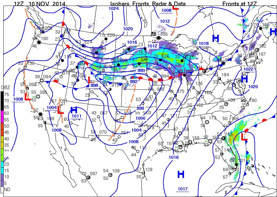
3 [ ]narrower [ ]wider 16.Around the low-pressure system, the visible image shows a broad white, comma shaped swirl of clouds. Consistent with the hand-twist model of a Low, an animation would show this swirl to be rotating [(clockwise)(counterclockwise)]. It is the circulation and rising motions of low-pressure systems that leads to the comma shape of cloudiness frequently seen in satellite images. [ ]clockwise [ ]counterclockwise 17.A broad, bright, white arc curling between Indiana and Florida is composed of clouds producing widespread precipitation at image time. The arc of clouds across this portion of the country forms the band spread ahead of the wave cyclone s [(cold)(stationary)] front. [ ]stationary 19. Figure 3 is the surface weather map for 12Z 10 NOV At map time, a wintry storm system was crossing the country with a low-pressure center in central Nebraska. The L was shown within the small closed 992-mb isobar with the lowest pressure of 990 mb (underlined just to the right above the L). From that Low center, a [(cold)(warm)(stationary)] front extended generally eastward to Lake Michigan, where the frontal boundary essentially took on stationary and then cold front identities as it extended into eastern Canada. [ ]warm [ ]stationary 20.Also from the Nebraska Low, a [(cold)(warm)(stationary)] front stretched generally westward across Wyoming before becoming stationary along the Rockies to the northwest. An extension of the isobar curves to the south of the Low center is marked by an orange dashed line or trough mainly showing a change of wind directions. [ ]warm [ ]stationary 21.The wind pattern in the several state area around the Low center exhibited a generally [(clockwise and outward)(counterclockwise and inward)] flow as expected. [ ]clockwise and outward [ ]counterclockwise and inward 22.The wind directions at Rapid City, SD, and Glasgow, in northeastern Montana, were generally from the [(south)(west)(north)(east)] as would be expected following the cold front in a wave
4 [ ]south [ ]west 23.The wind directions at Kansas City, and St. Louis, MO, were generally from the [(south)(west)(north)(east)] as could be expected in the warm sector, between the warm and cold fronts in a wave cyclone. [ ]south [ ]west 24.Compare the temperature at Denver with that at Casper, WY. The air was [(warmer)(colder)] to the north of (behind) the cold front. This region had a marked contrast in temperature, and the dewpoints differed as well. [ ]warmer er 25.Compare the temperatures and dewpoints at Kansas City, MO, and Minneapolis, MN. The air was [(warmer and had greater)(cooler and had lower)] water vapor content to the south of (behind) the warm front. [ ]warmer and had greater [ ]cooler and had lower 26.Precipitation, as represented by the radar echo shadings on the map, had widespread green hues. These precipitation areas were located generally [(north of the Low and warm front) (in the warm sector between the warm and cold fronts)(ahead the cold front)]. of the Low and warm front [ ]in the warm sector between the warm and cold fronts [ ]ahead of the cold front 27.Based on the temperatures and visible station weather symbols in this precipitation region, the form of the precipitation with the more intense radar echoes was probably [(rain)(snow)(drizzle)]. [ ]rain [ ]snow [ ]drizzle 28.Behind the cold front accompanying this storm system, there were [(0)(1)(3)(5)] isobars between the southern and northern borders of eastern Wyoming. This pressure pattern indicated a strong horizontal pressure gradient and probable strong winds over that area. [ ]0 [ ]1
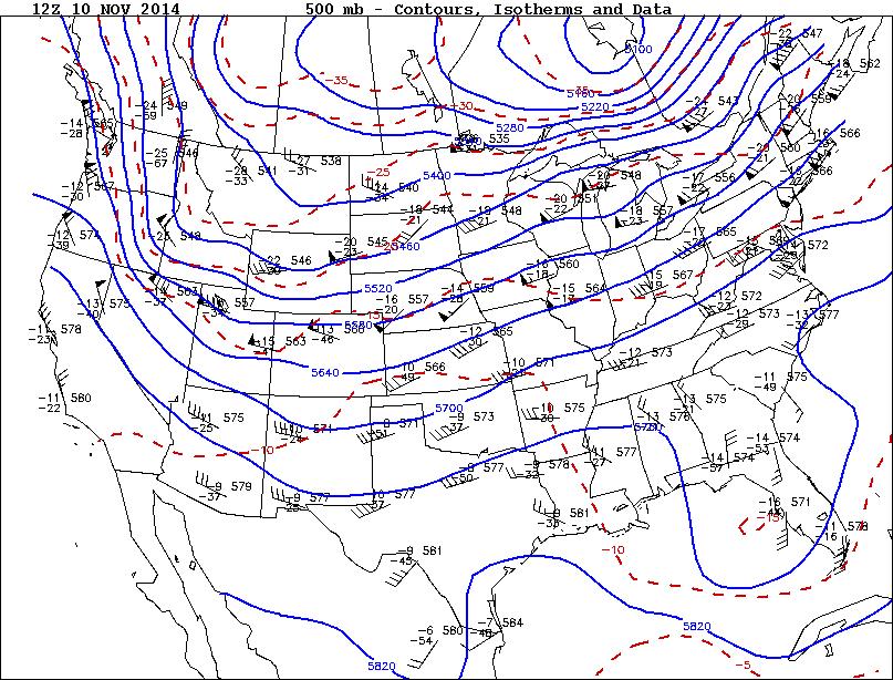
5 [ ]3 [ ]5 29.Figure 4 is the 500-mb upper-air map for 12Z 10 NOV 2014, the same time as the Figure 3 surface map. Mentally place a bold L on the Figure 4, 500-mb map where the surface 990-mb Low center of Figure 3 was shown. Wind directions at 500 mb over surface weather features are often a good indicator of the movements of those systems over the next day or so. Based on the wind directions at 500 mb as inferred by the station plots and contour lines over the area of the surface storm center, the system would be expected to move generally toward the [(east)(north)(west)(south)] over the next day. [ ]west [ ]south 30.Now look back to the Figure 3 surface map. Based on the frontal symbols, the cold front stretching from Nebraska to Wyoming would be expected to move generally toward the [(south)(east)(north)]. [ ]south 31.The warm front, as expected from the symbols, would likely move a little toward the [(east)(north)(west)(south)] over the same period. [ ]west [ ]south 32.The expected continuing advancement of the cold front and the Low would likely cause residents of the center portion of the country to see [(rapidly rising)(small changes in)(rapidly falling)] temperatures over the next day or so. [ ]rapidly rising [ ]small changes in [ ]rapidly falling
6 Figure 1:
7 Figure 2:
8 Figure 3:
9 Figure 4:
1. Which weather map symbol is associated with extremely low air pressure? A) B) C) D) 2. The diagram below represents a weather instrument.
 B) C) D) 2. The diagram below represents a weather instrument.") 1. Which weather map symbol is associated with extremely low air pressure? 2. The diagram below represents a weather instrument. Which weather variable was this instrument designed to measure? A) air pressure
1. Which weather map symbol is associated with extremely low air pressure? 2. The diagram below represents a weather instrument. Which weather variable was this instrument designed to measure? A) air pressure
Fronts. Direction of Front
 Fronts Direction of Front Direction of Front Warm Front A cold air mass meets and displaces a warm air mass. Because the moving cold air is more dense, it moves under the less-dense warm air, pushing it
Mid-Latitude Cyclones and Fronts. Lecture 12 AOS 101
 Mid-Latitude Cyclones and Fronts Lecture 12 AOS 101 Homework 4 COLDEST TEMPS GEOSTROPHIC BALANCE Homework 4 FASTEST WINDS L Consider an air parcel rising through the atmosphere The parcel expands as it
True or false: The atmosphere is always in hydrostatic balance. A. True B. False
 Clicker Questions and Clicker Quizzes Clicker Questions Chapter 7 Of the four forces that affect the motion of air in our atmosphere, which is to thank for opposing the vertical pressure gradient force
SEVERE WEATHER AND FRONTS TAKE HOME QUIZ
 1. Most of the hurricanes that affect the east coast of the United States originally form over the A) warm waters of the Atlantic Ocean in summer B) warm land of the southeastern United States in summer
4/29/2011. Mid-latitude cyclones form along a
 Chapter 10: Cyclones: East of the Rocky Mountain Extratropical Cyclones Environment prior to the development of the Cyclone Initial Development of the Extratropical Cyclone Early Weather Along the Fronts
Activity: Air Motion - The High and Low of It
 Activity: Air Motion - The High and Low of It Introduction Weather can be fair or stormy. Generally, fair weather is associated with high surface air pressure while stormy weather is associated with low
How Can You Predict Weather Changes?
 How Can You Predict Weather Changes? How to Predict Weather Meteorologists make weather predictions daily. They use the same processes that you will. They collect weather data. They plot the data on maps.
3. As warm, moist air moves into a region, barometric pressure readings in the region will generally 1. decrease 2. increase 3.
 Teacher: Mr. Prizzi Castle Learning Review 1 1. Which process most directly results in cloud formation? 1. condensation 3. precipitation 2. transpiration 4. radiation 2. An air mass originating over north
AIR MASSES. Large bodies of air. SOURCE REGIONS areas where air masses originate
 Large bodies of air AIR MASSES SOURCE REGIONS areas where air masses originate Uniform in composition Light surface winds Dominated by high surface pressure The longer the air mass remains over a region,
Page 1. Name:
 Name: 1) As the difference between the dewpoint temperature and the air temperature decreases, the probability of precipitation increases remains the same decreases 2) Which statement best explains why
Air Masses, Fronts, Storm Systems, and the Jet Stream
 Air Masses, Fronts, Storm Systems, and the Jet Stream Air Masses When a large bubble of air remains over a specific area of Earth long enough to take on the temperature and humidity characteristics of
Current Weather Studies 4 TEMPERATURE AND AIR MASS ADVECTION
 CWS 4-1 SP19 Current Weather Studies 4 TEMPERATURE AND AIR MASS ADVECTION Reference: Chapter 4 in the Weather Studies textbook. Complete the introductory and other appropriate sections of Investigations
Air Masses of North America cp and ca air masses Air mass characterized by very cold and dry conditions
 Chapter 8: Air Masses, Fronts, and Middle-Latitude Cyclones Air masses Fronts Middle-latitude cyclones Air Masses Air mass an extremely large body of air whose properties of temperature and humidity are
Lecture #14 March 29, 2010, Monday. Air Masses & Fronts
 Lecture #14 March 29, 2010, Monday Air Masses & Fronts General definitions air masses source regions fronts Air masses formation types Fronts formation types Air Masses General Definitions a large body
Fronts in November 1998 Storm
 Fronts in November 1998 Storm Much of the significant weather observed in association with extratropical storms tends to be concentrated within narrow bands called frontal zones. Fronts in November 1998
Forecasting Weather: Air Masses and Fronts
 Forecasting Weather: Air Masses and Fronts Weather is a combination of local conditions at any one time. It's what's happening outside right now, right here. Weather includes: Temperature Humidity Air
Lecture 14. Extratropical Cyclones extratropical cyclone
 Lecture 14. Extratropical Cyclones In mid-latitudes, much of our weather is associated with a particular kind of storm, the extratropical cyclone Cyclone: circulation around low pressure center Some midwesterners
Observation Homework Due 11/24. Previous Lecture. Midlatitude Cyclones
 Lecture 21 Midlatitude Cyclones Observation Homework Due 11/24 1 2 Midlatitude Cyclones Midlatitude Cyclone or Winter Storm Cyclogenesis Energy Source Life Cycle Air Streams Vertical Structure Storm Hazards
** warm air mass
 Frontal cyclones -otherwise known as mid-latitude or wave cyclones. A cyclone is a cyclonically rotating system which, in mid- and high-latitudes is normally associated with the boundary between air masses
What a Hurricane Needs to Develop
 Weather Weather is the current atmospheric conditions, such as air temperature, wind speed, wind direction, cloud cover, precipitation, relative humidity, air pressure, etc. 8.10B: global patterns of atmospheric
Air Masses and Fronts II
 Air Masses and Fronts II Brief review An air mass is a large body of air whose properties of temperature and humidity are fairly similar in any horizontal direction Source regions for air masses tend to
Go With the Flow From High to Low Investigating Isobars
 Go With the Flow From High to Low Investigating Isobars Science 10 Mrs. Purba Air Masses The air over a warm surface can be heated, causing it to rise above more dense air. The result is the formation
Chapter 12 Fronts & Air Masses
 Chapter overview: Anticyclones or highs Air Masses o Classification o Source regions o Air masses of North America Fronts o Stationary fronts o Cold fronts o Warm fronts o Fronts and the jet stream o Frontogenesis
Mid-latitude Cyclones & Air Masses
 Lab 9 Mid-latitude Cyclones & Air Masses This lab will introduce students to the patterns of surface winds around the center of a midlatitude cyclone of low pressure. The types of weather associated with
b. The boundary between two different air masses is called a.
 NAME Earth Science Weather WebQuest Part 1. Air Masses 1. Find out what an air mass is. http://okfirst.mesonet.org/train/meteorology/airmasses.html a. What is an air mass? An air mass is b. The boundary
Weather Systems. Section
 Section 1 12.2 Objectives Compare and contrast the three major wind systems. Identify four types of fronts. Distinguish between highand low-pressure systems. Review Vocabulary convection: the transfer
AIR MASSES SOURCE REGION CHARACTERISTICS Continental Arctic (ca) Greenland, Antarctica, Highest latitudes of Asia and North America
 Greenland, Antarctica, Highest latitudes of Asia and North America") GEOGRAPHY CLIMATOLOGY AIRMASS, FRONT AND TEMPERATE CYCLONE AIRMASS A large body of air having little horizontal variation in temperature and moisture is called an airmass. Airmass acquires its properties
GEOGRAPHY CLIMATOLOGY AIRMASS, FRONT AND TEMPERATE CYCLONE AIRMASS A large body of air having little horizontal variation in temperature and moisture is called an airmass. Airmass acquires its properties
Chapter 1 Anatomy of a Cyclone
 Chapter 1 Anatomy of a Cyclone The Beast in the East 15-17 February 2003 Extra-tropical cyclone an area of low pressure outside of the tropics Other names for extra-tropical cyclones: Cyclone Mid-latitude
Summary of November Central U.S. Winter Storm By Christopher Hedge
 Summary of November 12-13 2010 Central U.S. Winter Storm By Christopher Hedge Event Overview The first significant snowfall of the 2010-2011 season affected portions of the plains and upper Mississippi
Chapter 9: Weather Patterns
 Chapter 9: Weather Patterns Mid Latitude Cyclones: extratropical cyclones, Nor easters Region southern FL to Alaska Lifecycle and associated weather Regional Influence Polar Front Theory: -Norwegian Cyclone
Divergence, Spin, and Tilt. Convergence and Divergence. Midlatitude Cyclones. Large-Scale Setting
 Midlatitude Cyclones Equator-to-pole temperature gradient tilts pressure surfaces and produces westerly jets in midlatitudes Waves in the jet induce divergence and convergence aloft, leading to surface
Guided Notes Weather. Part 1: Weather Factors Temperature Humidity Air Pressure Winds Station Models
 Guided Notes Weather Part 1: Weather Factors Temperature Humidity Air Pressure Winds Station Models. 1. What is weather? Weather: short-term atmospheric conditions in a specific area at a specific time
5. Which type of front is represented by letter X?
 Name Weather Regents Review ased your answers to questions 1 through 4 on the four weather station models,,,, and D, below. D 82 012 56 999 78 978 32 002 62 75 24 1. List the letters of the four station
RR#4 - Multiple Choice
 1. The map below shows the amount of snowfall, in inches, produced by a lake-effect snowstorm in central New York State. The wind that produced this snowfall pattern most likely came from the 1) northeast
Chapter 10: Mid-latitude Cyclones Mid-Latitude Cyclones
 Chapter 10: Mid-latitude Cyclones Mid-Latitude Cyclones Mid-latitude cyclones form along a boundary separating polar air from warmer air to the south. Life Cycle of Cyclone Cyclone Structures Steering
Chapter 10: Mid-latitude Cyclones
 Chapter 10: Mid-latitude Cyclones Life Cycle of Cyclone Cyclone Structures Steering of Cyclone Mid-Latitude Cyclones Mid-latitude cyclones form along a boundary separating polar air from warmer air to
Chapter 9. Weather Patterns & Midlatitude Cyclones
 Chapter 9 Weather Patterns & Midlatitude Cyclones Frontal Weather Fronts are boundary surfaces between different air masses. Warm front Cold front Stationary front Occluded front Drylines Frontal Weather
Weather Unit Part 2: Meteorology
 Name: Earth Science Date: Period: Weather Unit Part 2: Meteorology 1 The map below shows North America and its surrounding bodies of water. Country borders are shown. On the map, label the following locations:
Section Fronts 1 FOCUS Section Objectives Key Concepts Vocabulary Reading Strategy 20.5 Describe Outlining 20.
 Section 20.2 20.2 Fronts 1 FOCUS Section Objectives 20.5 Describe the formation of a front. 20.6 Differentiate among the formation of a warm front, cold front, stationary front, and occluded front. 20.7
Pressure System Circulation
 NAME 1. Base your answer to the following question on the surface weather map shown below. The map shows weather systems over the United States and weather station data for cities A, B, C, and D. Note
4. Which map best represents the type of fronts and direction of movement of these fronts in relation to the low-pressure center?
 1. Adjacent water and landmasses are heated by the morning Sun on a clear, calm day. After a few hours, a surface wind develops. Which map best represents this wind's direction? 2. An air pressure of 29.47
MET 3502 Synoptic Meteorology. Lecture 8: September 16, AIRMASSES, FRONTS and FRONTAL ANALYSIS (2)
") MET 3502 Synoptic Meteorology Lecture 8: September 16, 2010 AIRMASSES, FRONTS and FRONTAL ANALYSIS (2) Identifying a cold front on a surface weather map: 1. Surface front is located at the leading edge
MET 3502 Synoptic Meteorology Lecture 8: September 16, 2010 AIRMASSES, FRONTS and FRONTAL ANALYSIS (2) Identifying a cold front on a surface weather map: 1. Surface front is located at the leading edge
Pilots watch the clouds, because clouds can indicate the kind of weather in store for a flight.
 Low stratus Cumulonimbus Pilots watch the clouds, because clouds can indicate the kind of weather in store for a flight. FILL IN THE BLANKS OR CIRCLE ONE: A. Stratus means flat or on one level. Low stratus
WEATHER. Review Note Cards
 WEATHER Review Note Cards Thermometer Weather instrument that measures air temperature Units include F, C, and K ESRT 13 Sling Psychrometer Weather instrument that measures relative humidity and dewpoint
Unit Three Worksheet Meteorology/Oceanography 2 WS GE U3 2
 Unit Three Worksheet Meteorology/Oceanography 2 WS GE U3 2 Name Period Section 17.3 1. 2. 3. 4. 5. 6. 7. 8. Of the following, which is NOT a factor that controls temperature? (C) latitude (D) longitude
Transient and Eddy. Transient/Eddy Flux. Flux Components. Lecture 3: Weather/Disturbance. Transient: deviations from time mean Time Mean
 Lecture 3: Weather/Disturbance Transients and Eddies Climate Roles Mid-Latitude Cyclones Tropical Hurricanes Mid-Ocean Eddies Transient and Eddy Transient: deviations from time mean Time Mean Eddy: deviations
Name SOLUTIONS T.A./Section Atmospheric Science 101 Homework #6 Due Thursday, May 30 th (in class)
") Name SOLUTIONS T.A./Section Atmospheric Science 101 Homework #6 Due Thursday, May 30 th (in class) 1. General Circulation Briefly describe where each of the following features is found in the earth s general
Name SOLUTIONS T.A./Section Atmospheric Science 101 Homework #6 Due Thursday, May 30 th (in class) 1. General Circulation Briefly describe where each of the following features is found in the earth s general
Weather, Air Masses, Fronts and Global Wind Patterns. Meteorology
 Weather, Air Masses, Fronts and Global Wind Patterns Meteorology Weather is what conditions of the atmosphere are over a short period of time. Climate is how the atmosphere "behaves" over long periods
Middle Latitude Cyclones a storm that forms at middle and high latitudes, outside of the tropics.
 Middle Latitude Cyclones a storm that forms at middle and high latitudes, outside of the tropics. Polar Front Theory a theory that explains the life cycle of mid latitude cyclones and their associated
Weather and Energy Review
 Weather and Energy Review Name 1. Base your answer to the following question on the diagram below, which represents the greenhouse effect in which heat energy is trapped in Earth's atmosphere Which type
air masses and Fronts 2013.notebook January 29, 2013
 1/4/12 Notes 1 Weather Data Log.docx 2 Air Masses Uniform bodies of air An air mass is a large body of air that has similar temperature and moisture throughout. How to name an air mass: first write the
Clouds. What they tell us about the weather
 Clouds What they tell us about the weather Spring funnel cloud over Willard, Utah 2003 Cloud coverage 581-586 How to show Cloud Coverage On a weather map meteorologists use circles shaded differently to
CHAPTER THREE Mechanics of Frontal Systems
 Mechanics of Frontal Systems 300. INTRODUCTION The purpose of this chapter is to introduce the student to various frontal systems, including their formation, flight conditions, and associated weather patterns,
10/21/2012. Chapter 10 Thunderstorms. Part II. Growth and Development of ordinary Cell Thunderstorms Thunderstorm Electrification.
 Chapter 10 Thunderstorms Part I Growth and Development of ordinary Cell Thunderstorms Thunderstorm Electrification Tornadoes Part II Simplified model depicting the life cycle of an ordinary thunderstorm
Foundations of Earth Science, 6e Lutgens, Tarbuck, & Tasa
 Foundations of Earth Science, 6e Lutgens, Tarbuck, & Tasa Weather Patterns and Severe Weather Foundations, 6e - Chapter 14 Stan Hatfield Southwestern Illinois College Air masses Characteristics Large body
Key. Name: OBJECTIVES
 Name: Key OBJECTIVES Correctly define: air mass, air pressure, anemometer, barometer, cyclone, dew point, front, isobar, isotherm, meteorology, precipitation, psychrometer, relative humidity, saturated,
PLOTTING WEATHER DATA to perform a SURFACE ANALYSIS
 PLOTTING WEATHER DATA to perform a SURFACE ANALYSIS The surface analysis permits one to identify and locate the large scale features of the sea level pressure field and the surface fronts. Isobars with
A) B) C) D) 2) The diagrams below show the phases of the Moon as viewed by an observer in New York State at different times in August.
 B) C) D) 2) The diagrams below show the phases of the Moon as viewed by an observer in New York State at different times in August.") Name: 1) Which weather station model indicates the highest relative humidity? 8605-1 - Page 1 A) B) C) D) 2) The diagrams below show the phases of the Moon as viewed by an observer in New York State at
Name: 1) Which weather station model indicates the highest relative humidity? 8605-1 - Page 1 A) B) C) D) 2) The diagrams below show the phases of the Moon as viewed by an observer in New York State at
Middle-Latitude Cyclone
 Middle-Latitude Cyclone What is a mid-latitude cyclone? - The mid-latitude cyclone is a synoptic scale low pressure system that has cyclonic (counter-clockwise in northern hemisphere) flow that is found
MASTERY ASSIGNMENT 2015
 Climate & Meteorology MASTERY ASSIGNMENT 2015 Directions: You must submit this document via Google Docs to lzimmerman@wcpss.net. The document must include the questions and pictures must be hand drawn
Activity: A Satellite Puzzle
 Activity: A Satellite Puzzle Introduction Satellites provide unique views of Earth. The imagery acquired by these space platforms reveal weather systems and broad-scale circulation patterns that can be
Chapter22 Weather Maps
 Name Teacher Period Date hapter22 Weather Maps hapter 22 Skill Sheet 1: Fronts Air masses are bodies of air that are relatively uniform in temperature and humidity. These bodies of air take on the characteristic
Climate vs. Weather. Weather: Short term state of the atmosphere. Climate: The average weather conditions in an area over a long period of time
 Weather and Climate Climate vs. Weather Weather: Short term state of the atmosphere. Temperature, humidity, cloud cover, precipitation, winds, visibility, air pressure, air pollution, etc Climate: The
Weather Systems III: Thunderstorms and Twisters
 Weather Systems III: Thunderstorms and Twisters Review 1. Definition of airmasses? Bergeron classification of air masses 2. Surface weather analysis: Station model, wind speed code, present weather 3.
Chapter 12 Section 12.1 The causes of weather
 Chapter 12 Section 12.1 The causes of weather Main Idea: Air masses have different temperatures and amounts of moisture because of the uneven heating of earth's surface. What is Meteorology The study of
Name: Section/TA Name: Atmospheric Science 101, Spring 2003 Midterm 2 Thursday 22 May 2003 Version A
 Name: Section/TA Name: Atmospheric Science 101, Spring 2003 Midterm 2 Thursday 22 May 2003 Version A Multiple Choice (2 points each) Choose the best answer and mark it on a Scantron sheet. 1. Choose the
Air Masses, Weather Systems and Hurricanes
 The Earth System - Atmosphere IV Air Masses, Weather Systems and Hurricanes Air mass a body of air which takes on physical characteristics which distinguish it from other air. Classified on the basis of
Investigation 11.3 Weather Maps
 Name: Date: Investigation 11.3 Weather Maps What can you identify weather patterns based on information read on a weather map? There have been some amazing technological advancements in the gathering and
Weather Studies Introduction to Atmospheric Science
 Weather Studies Introduction to Atmospheric Science American Meteorological Society Chapter 1 Monitoring The Weather Credit: This presentation was prepared for AMS by Michael Leach, Professor of Geography
Synoptic Meteorology II: Self-Development in the IPV Framework. 5-7 May 2015
 Synoptic Meteorology II: Self-Development in the IPV Framework 5-7 May 2015 Readings: Section 5.3.6 of Midlatitude Synoptic Meteorology. Introduction In this and other recent lectures, we have developed
YOU MUST USE WHAT YOU KNOW ABOUT THE MOVEMENT OF AIR MASSES DUE TO THE CORIOLIS EFFECT TO FORECAST!
 For this project you will apply past and present data to predict and future weather patterns and events and justify the predictions in terms of energy transfer between various systems. You will use this
Weather Related Factors of the Adelaide floods ; 7 th to 8 th November 2005
 Weather Related Factors of the Adelaide floods ; th to th November 2005 Extended Abstract Andrew Watson Regional Director Bureau of Meteorology, South Australian Region 1. Antecedent Weather 1.1 Rainfall
Figure 1. Idealized global atmospheric circulation (C = surface convergence, D = surface divergence).
.") page - Laboratory Exercise #8 - Introduction to Atmospheric Science: Global Circulation and Weather Makers Section A - Global Atmospheric Circulation: To understand weather you need to understand how the
page - Laboratory Exercise #8 - Introduction to Atmospheric Science: Global Circulation and Weather Makers Section A - Global Atmospheric Circulation: To understand weather you need to understand how the
Weather Practice Test
 Name: Weather Practice Test 1. The diagram below shows weather instruments A and B. Which table correctly indicates the name of the weather instrument and the weather variable that it measures? A) B) C)
DOWNLOAD PDF READING CLIMATE MAPS
 Chapter 1 : Template:Climate chart/how to read a climate chart - Wikipedia Maps don't just tell you which way to go they can tell you practically everything about an area of land, even the weather. Learn
Weather FActors. May 8 4:15 PM. Analyzing AIR MASSES & THEIR MOVEMENT
 ` Weather FActors P: Analyze weather Q: What are the factors that cause weather? May 8 4:15 PM Analyzing AIR MASSES & THEIR MOVEMENT Read and take notes... Using pages 72-79: (IN YOUR JOURNAL!) - Identify
Science 1206 Chapter 1 - Inquiring about Weather
 Science 1206 Chapter 1 - Inquiring about Weather 1.1 - The Atmosphere: Energy Transfer and Properties (pp. 10-25) Weather and the Atmosphere weather the physical conditions of the atmosphere at a specific
The Transfer of Heat
 The Transfer of Heat Outcomes: S2-4-03 Explain effects of heat transfer within the atmosphere and hydrosphere on the development and movement of wind and ocean currents. Coriolis Effect In our ecology
Answers to Clicker Questions
 Answers to Clicker Questions Chapter 1 What component of the atmosphere is most important to weather? A. Nitrogen B. Oxygen C. Carbon dioxide D. Ozone E. Water What location would have the lowest surface
Guided Reading Chapter 18: Weather Patterns
 Name Number Date Guided Reading Chapter 18: Weather Patterns 18-1: Air Masses and Fronts 1. What is an air mass? 2. Scientists classify air masses according to and 3. Is the following sentence true or
Space Atmospheric Gases. the two most common gases; found throughout all the layers a form of oxygen found in the stratosphere
 Earth s atmospheric layers Earth s atmosphere is the layer of gases that surrounds the planet and makes conditions on Earth suitable for living things. Layers Earth s atmosphere is divided into several
Anticipation Guide #2
 Weather Systems Anticipation Guide #2 Density differences in the atmosphere are responsible for redistributing earth s heat When air is heated it rises, cools and expands releasing energy mt air masses
25.1 Air Masses. Section 25.1 Objectives
 Section 25.1 Objectives Explain how an air mass forms. List the four main types of air masses. Describe how air masses affect the weather of North America. Air Masses 25.1 Air Masses Differences in air
Science Olympiad Meteorology Quiz #2 Page 1 of 8
 1) The prevailing general direction of the jet stream is from west to east in the northern hemisphere: 2) Advection is the vertical movement of an air mass from one location to another: 3) Thunderstorms
Chapter 3 Convective Dynamics 3.4. Bright Bands, Bow Echoes and Mesoscale Convective Complexes
 Chapter 3 Convective Dynamics 3.4. Bright Bands, Bow Echoes and Mesoscale Convective Complexes Photographs Todd Lindley Bright band associated with stratiform precipitation in a squall line system 1 Bright
Lecture Outlines PowerPoint. Chapter 19 Earth Science 11e Tarbuck/Lutgens
 Lecture Outlines PowerPoint Chapter 19 Earth Science 11e Tarbuck/Lutgens 2006 Pearson Prentice Hall This work is protected by United States copyright laws and is provided solely for the use of instructors
Earth Science, 11e. Weather Patterns and Severe Storms Chapter 19. Air masses. A cold Canadian air mass Figure Air masses. Air masses 9/5/2012
 2006 Pearson Prentice Hall Lecture Outlines PowerPoint Chapter 19 Earth Science 11e Tarbuck/Lutgens This work is protected by United States copyright laws and is provided solely for the use of instructors
Tuesday, September 13, 16
 Weather Weather State Objectives 4.c, 4.d, 4.h. Discussion What are some ways in which weather affects your everyday life? Discussion What are some ways in which weather affects your everyday life? What
Name Block. My Junior Meteorologist Packet
 Name Block My Junior Meteorologist Packet 1 1 WEATHER INSTRUMENTS TUESDAY WARM UP- WEATHER TOOLS MATCH UP Write the letter of the weather instrument in the blank to show the correction function. 2 WEDNESDAY
Weather - is the state of the atmosphere at a specific time & place
 Weather Section 1 Weather - is the state of the atmosphere at a specific time & place Includes such conditions as air pressure, wind, temperature, and moisture in the air The Sun s heat evaporates water
Science 1206 SAMPLE Test ( Weather Dynamics)
") Science 1206 SAMPLE Test ( Weather Dynamics) Name:. Part A: Multiple Choice (60%) Shade the letter of the best answer on the Scantron sheet provided. 1. Which term refers to the current atmospheric conditions?
Science 1206 SAMPLE Test ( Weather Dynamics) Name:. Part A: Multiple Choice (60%) Shade the letter of the best answer on the Scantron sheet provided. 1. Which term refers to the current atmospheric conditions?
 http://www.ssec.wisc.edu/data/composites.html Red curve: Incoming solar radiation Blue curve: Outgoing infrared radiation. Three-cell model of general circulation Mid-latitudes: 30 to 60 latitude MID-LATITUDES
Guided Notes Weather. Part 2: Meteorology Air Masses Fronts Weather Maps Storms Storm Preparation
 Guided Notes Weather Part 2: Meteorology Air Masses Fronts Weather Maps Storms Storm Preparation The map below shows North America and its surrounding bodies of water. Country borders are shown. On the
ATSC 2000 Final Fall 2005
 ATSC 2000 Final Fall 2005 true/false /25 multiple choice /25 short answer /23 essay /10 total /83 or % True/False Indicate whether the sentence or statement is true or false. (25 questions 1% each) 1.
ATS 351, Spring 2010 Lab #11 Severe Weather 54 points
 ATS 351, Spring 2010 Lab #11 Severe Weather 54 points Question 1 (10 points): Thunderstorm development a) Sketch and describe the stages of development of a single cell thunderstorm. About how long does
ALL PRESSURE VARIABLES AND STATION MODELS MEGA PACKET
 NAME: MEGA PACKET 1. A change in the type and location of large high-pressure systems (H) and large low-pressure systems ( L) over Asia creates shifts in prevailing winds that cause a rainy summer season
The Planetary Circulation System
 12 The Planetary Circulation System Learning Goals After studying this chapter, students should be able to: 1. describe and account for the global patterns of pressure, wind patterns and ocean currents
Meteorology Lecture 18
 Meteorology Lecture 18 Robert Fovell rfovell@albany.edu 1 Important notes These slides show some figures and videos prepared by Robert G. Fovell (RGF) for his Meteorology course, published by The Great
Global Weather Trade Winds etc.notebook February 17, 2017
 Global Weather 1 north pole northern hemisphere equator southern hemisphere south pole 2 We have seasons because of the Earth's tilt The seasons are opposite in the northern and southern hemispheres winter