|
|
|
- Jodie Walton
- 6 years ago
- Views:
Transcription
1
2
3
4

5

6 Red curve: Incoming solar radiation Blue curve: Outgoing infrared radiation.


")
7 Three-cell model of general circulation Mid-latitudes: 30 to 60 latitude MID-LATITUDES Mid-latitude cyclones do the job of transporting heat poleward. TROPICS Tropics: 0 to about 30 latitude A thermally direct circulation (Hadley cell) transports heat poleward.
 develop along the polar front.")
8 General circulation in mid-latitudes Air flows away from the subtropical high toward the polar front, or boundary between warm subtropical air and cold polar air. Because of the Coriolis force, the winds are westerly. 2. Air converges and rises at the polar front. Mid-latitude cyclones (or areas of low pressure) develop along the polar front. The mid-latitude cyclones transport warm air toward the pole and cool air toward the equator. 3. Some of the air returns toward the subtropics, completing an indirect thermal circulation (Ferrel cell).


9 Mid-latitude cyclone example (Major Midwest storm) WARM AIR TOWARD POLE COLD AIR TOWARD EQUATOR

10 Polar Jet Stream Result of the polar front boundary The rapid change between warm and cold air along the polar front results in a strong pressure gradient, and winds, there. This upper-level wind is called the polar jet stream.
 Heat applied to outer ring")
 http://paoc.mit.")
11 Dishpan experiment View looking down on the rotating dishpan (in rotating frame) Heat applied to outer ring Cooling applied to inner ring Add a particle tracer to the fluid (Holton)
12 Polar jet stream in Midwest storm example COLD AIR Note the very strong winds around the trough of low pressure. WARM AIR

13 Integrated picture of Jet Streams and the three-cell general circulation model. Jet streams occur near the tropopause. Subtropical jet defines the limit of the Hadley Cell. Polar jet is equatorward of the polar front.


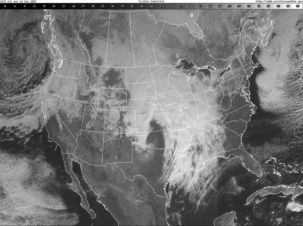
14 The Pineapple Express An example of an atmospheric river mt If the jet stream picks up this moisture from the tropics, this can result in very heavy rains along the west coast in winter.
15

16 Four types of fronts COLD FRONT: Cold air overtakes warm air. B to C WARM FRONT: Warm air overtakes cold air. C to D OCCLUDED FRONT: Cold air catches up to the warm front. C to Low pressure center STATIONARY FRONT: No movement of air masses. A to B

17 Type of weather and air masses in relation to fronts: Feb. 24, 2007 case mp cp mt
18 Characteristics of a front 1. Sharp temperature changes over a short distance 2. Changes in moisture content 3. Wind shifts 4. A lowering of surface pressure, or pressure trough 5. Clouds and precipitation


19 COLD FRONT Horizontal extent: About 50 km AHEAD OF FRONT: Warm and southerly winds. Cirrus or cirrostratus clouds. Called the warm sector. AT FRONT: Pressure trough and wind shift. Area of rain showers, which can be thunderstorms if the air ahead of the front is warm and moist enough. Unstable, vertically developed clouds. BEHIND FRONT: Rapid clearing and drying in the cold air. Pressure rises. Winds typically northerly or westerly.
20

21 Fronts follow the pressure trough


22 Note rapid change in dew point temperature and temperature in the vicinity of the cold front.

23 Typically a line or lines of showers or thunderstorms on a cold front. These are called squall lines.

24 ENHANCED IR SATELLITE IMAGE Very cold, highly vertically developed clouds along the cold front in Arkansas where the squall lines are. APPROXIMATE COVERAGE OF LITTLE ROCK RADAR
25

26 FREEZING RAIN STEADY RAIN

27 Rain on a warm front is typically widespread and steady. It is also not typically very heavy, as with the thunderstorms on the cold front. Note the lack of the really strong radar echoes here (i.e. not a lot of orange and red colors).

28 Freezing rain is occurring in Iowa where the radar reflectivity is highest (yellows)


29 Far enough north and west of the warm front is typically where the snow happens because the cold air is deep enough. Radar color key RAIN L FREEZING RAIN or SLEET SNOW
30 SNOW


31 OCCLUDED FRONT Cold front catches up to the warm front, forming a wedge of warm air above the ground. At the occlusion, precipitation may range from widespread and steady to localized and heavy. Near the center of the low pressure.

32 L
33 Tucson cold front passage Things to Note: Wind shifts (trees and smoke stack) Precipitation (squall lines) Temperature drop and lowering of cloud bases Clearing at the end

34 AHEAD OF WARM FRONT Temp: Slow Warming Press: Falling Wind: E-SE Dew Pt: Rising Sky: Lowering Ceiling Wx: Steady Precip., Low Vis. BEHIND COLD FRONT Temp: Rapid Cooling Press: Rapid Rising Wind: W-NW Dew Pt: Lowering Sky: Clearing Wx: Improving AHEAD OF COLD FRONT Temp: Warm Press: Steady Wind: S-SW Dew Pt: High Sky: Variable Wx: Showers and T-storms WARM SECTOR
35 Mid-latitude cyclone example Late February 2007 Weather fronts are typically associated with mid-latitude cyclones (or extratropical cyclones). These have a very organized structure. Purpose of the mid-latitude cyclones in the general circulation is to transport energy from equator to pole: Transport warm air toward pole and upward. Transport cold air toward equator and downward. This process is called baroclinic instability a type of instability in the atmosphere which arises due to temperature gradients.

36 Vilhelm Bjerknes

37 Bjerknes Polar Front Model This sequence of events typically lasts on a timescale of days to a week.

38 Bjerknes Polar Front Model Step 1: Stationary Front A stationary frontal boundary forms between cold and warm air. This sets up a wind shear zone along the front.

39 Bjerknes Polar Front Model Step 2: Frontal wave A trigger (usually an upper level trough) causes the formation of low pressure along the front. Warm and colds fronts begin to form.

40 Bjerknes Polar Front Model Step 3: Open wave Low pressure begins to deepen. Warm and cold fronts become more defined. A warm sector forms ahead of the cold front and this is typically where the most severe weather occurs.

41 Bjerknes Polar Front Model Step 4: Mature cyclone Low pressure deepens more. Cold front begins to catch up to the warm front near the center of low pressure, forming an occluded front.

42 Bjerknes Polar Front Model Step 5: Occluded stage Mid-latitude cyclone most intense here. Low deepens to its lowest pressure. TRIPLE POINT Occluded front near the center of the low pressure. Recall the types of weather associated with the fronts at this stage. A new area of low pressure may form where all three fronts meet, called the triple point.

43 Bjerknes Polar Front Model Step 6: Cut off stage Center of storm gradually dissipates as cold air removes the occluded front, depriving the storm of warm and moist air.
44 Idealized dynamical perspective of baroclinic instability: Eady Problem Conceptual setup Frictionless, hydrostatic, f-plane in vertical Consider 2-D plane in x-z with rigid lid on top and bottom Linear vertical wind shear profile (implies baroclinicity, why???) Basic state potential vorticity (q) of zero in the interior of domain Initial sources of PV on upper and lower boundaries. PV Source (upper) q > 0 Vertical wind profile q > 0 PV Source (lower) q = 0 Z = TOA Z = 0
45 Physical implication of solution Assuming a wave solution, a dispersion relation can be constructed for phase speed Because there are real and imaginary parts to the phase speed solution, possibility for exponential growth PV Source (upper) q > 0 Z = TOA Amplification = PV sources are within a preferred range of distance that they begin to interact with each other. Growing solutions only occur for wavelengths greater than ~2500 km Short-wave cutoff Fastest growing waves about ~4000 km Most unstable Eady mode. Vertical wind speed profile q > 0 PV Source (lower) q = 0 Z = 0
46 Characteristics of most unstable Eady mode Tilted structure to highs and lows (as seen by streamfunction solution) Isobars cross isotherms Maximum southerly winds and rising motion ahead of upper-level low Maximum northerly winds and sinking motion ahead of upper-level high Just about what you get for a real mid-latitude cyclone in the mature to occluded stage!

47 Question to all of you DO WE NEED TO GO OVER THE COMPLETE DERIVATION AS PART OF A MORE COMPREHENSIVE DISCUSSION OF BAROTROPIC AND BAROCLINIC INSTABILITY IN THIS COURSE?? I m willing to do so later in the course if interest and time allows. Maybe necessary because we have students that are only taking 1 semester of dynamics?? Would be best to do this in the context of isotropic analysis and potential vorticity (about ¾ way into course)
48 Vorticity Equation Synoptic and Mesoscale contributions y F x F p p u y p v x p V t x y a a a a A C D E F B A = local time rate of change term B = Horizontal vorticity advection (PVA or NVA) C = Vertical vorticity advection D = Tilting of vorticity in the horizontal to the vertical E = Vortex stretching (Diabatic heating or terrain changes) F = Friction

49 Favored Mid-Latitude Cyclone Genesis Areas Typical mid-latitude cyclone tracks in North America. Origin points typically are pre-existing climatologically favored areas for vorticity generation Lee of mountain ranges: Vortex stretching Air going downslope tends to induce formation of surface lows. Examples: Colorado Lows, Alberta clippers. Over warm water: Q dot source Provides a source of energy due to latent heat release in clouds Examples: Gulf of Mexico Lows, Nor esters.


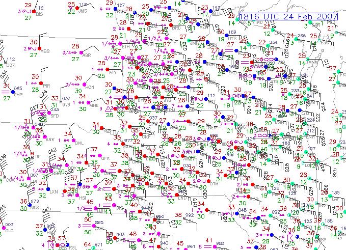
50 Open Wave Stage 0300 UTC, Saturday, Feb. 24, 2007 Note formation of low pressure in eastern CO. IR Imagery
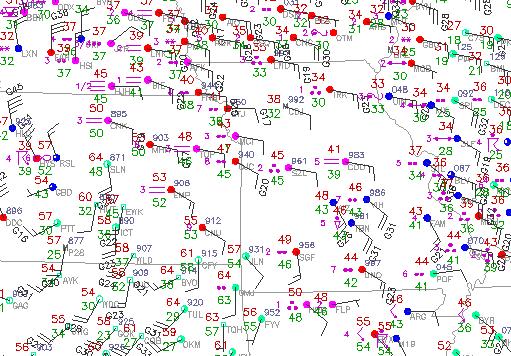
51 Mature Cyclone, Occluded Stage 1700 UTC, Saturday, Feb. 24, 2007 IR Imagery

52 Bjerknes cyclone development model with upper levels included NACENT AMPLIFYING DECAYING Stationary front Stationary front in longwave trough Maturing cyclone Shortwave initiates deepening of trough and vertical motion to develop a mature midlatitude cyclone. Cut off stage System becomes vertically stacked and upper level divergence over surface low ceases.
53 Upper level vs. surface features February 2007 example case Vorticity maximum X JET STREAK Surface low will form to the north and east of the jet streak because the upper level divergence is most favorable there (see discussion in text).
. Analogous to dishpan experiment discussed in the general circulation lecture.")
54 Longwaves and Shortwaves Longwaves or planetary waves arise because of the equator to pole temperature gradient These have modest levels of upper-level divergence (shaded red areas). Analogous to dishpan experiment discussed in the general circulation lecture.
55 Troughs, Ridges and Vorticity Dashed lines indicate lines of constant vorticity, or spin. NEGATIVE VORTICITY: ANTICYCLONIC ROTATION Height 1 Height 2 N X POSITIVE VORTICITY: CYCLONIC ROTATION RISING MOTION AHEAD OF POSITIVE VORTICITY SINKING MOTION AHEAD OF NEGATIVE VORTICITY The vorticity maximum (X or N) defines the axis of rotation.

56 Longwaves and Shortwaves X X X X X X Shortwaves are smaller scale disturbances imbedded in the flow, or local maximums of positive vorticity (X). These provide an additional source of upper-level divergence. Initiates cyclone development and deepens the longwave troughs and ridges. What a meteorologist looks for to forecast storm development this is what your TV weather forecaster sometimes calls a piece of energy

57 Note Absolute vorticity includes the effects of Earth s rotation, so it is always positive. X = relative vorticity maximum N = relative vorticity minimum
Chapter 12 Fronts & Air Masses
 Chapter overview: Anticyclones or highs Air Masses o Classification o Source regions o Air masses of North America Fronts o Stationary fronts o Cold fronts o Warm fronts o Fronts and the jet stream o Frontogenesis
Air Masses of North America cp and ca air masses Air mass characterized by very cold and dry conditions
 Chapter 8: Air Masses, Fronts, and Middle-Latitude Cyclones Air masses Fronts Middle-latitude cyclones Air Masses Air mass an extremely large body of air whose properties of temperature and humidity are
Middle-Latitude Cyclone
 Middle-Latitude Cyclone What is a mid-latitude cyclone? - The mid-latitude cyclone is a synoptic scale low pressure system that has cyclonic (counter-clockwise in northern hemisphere) flow that is found
Mid-Latitude Cyclones and Fronts. Lecture 12 AOS 101
 Mid-Latitude Cyclones and Fronts Lecture 12 AOS 101 Homework 4 COLDEST TEMPS GEOSTROPHIC BALANCE Homework 4 FASTEST WINDS L Consider an air parcel rising through the atmosphere The parcel expands as it
Observation Homework Due 11/24. Previous Lecture. Midlatitude Cyclones
 Lecture 21 Midlatitude Cyclones Observation Homework Due 11/24 1 2 Midlatitude Cyclones Midlatitude Cyclone or Winter Storm Cyclogenesis Energy Source Life Cycle Air Streams Vertical Structure Storm Hazards
Divergence, Spin, and Tilt. Convergence and Divergence. Midlatitude Cyclones. Large-Scale Setting
 Midlatitude Cyclones Equator-to-pole temperature gradient tilts pressure surfaces and produces westerly jets in midlatitudes Waves in the jet induce divergence and convergence aloft, leading to surface
ATMO 436a. The General Circulation. Redacted version from my NATS lectures because Wallace and Hobbs virtually ignores it
 ATMO 436a The General Circulation Redacted version from my NATS lectures because Wallace and Hobbs virtually ignores it Scales of Atmospheric Motion vs. Lifespan The general circulation Atmospheric oscillations
Lec 10: Interpreting Weather Maps
 Lec 10: Interpreting Weather Maps Case Study: October 2011 Nor easter FIU MET 3502 Synoptic Hurricane Forecasts Genesis: on large scale weather maps or satellite images, look for tropical waves (Africa
4/29/2011. Mid-latitude cyclones form along a
 Chapter 10: Cyclones: East of the Rocky Mountain Extratropical Cyclones Environment prior to the development of the Cyclone Initial Development of the Extratropical Cyclone Early Weather Along the Fronts
Middle Latitude Cyclones a storm that forms at middle and high latitudes, outside of the tropics.
 Middle Latitude Cyclones a storm that forms at middle and high latitudes, outside of the tropics. Polar Front Theory a theory that explains the life cycle of mid latitude cyclones and their associated
Chapter 9: Weather Patterns
 Chapter 9: Weather Patterns Mid Latitude Cyclones: extratropical cyclones, Nor easters Region southern FL to Alaska Lifecycle and associated weather Regional Influence Polar Front Theory: -Norwegian Cyclone
Lecture 14. Extratropical Cyclones extratropical cyclone
 Lecture 14. Extratropical Cyclones In mid-latitudes, much of our weather is associated with a particular kind of storm, the extratropical cyclone Cyclone: circulation around low pressure center Some midwesterners
Chapter 10: Mid-latitude Cyclones Mid-Latitude Cyclones
 Chapter 10: Mid-latitude Cyclones Mid-Latitude Cyclones Mid-latitude cyclones form along a boundary separating polar air from warmer air to the south. Life Cycle of Cyclone Cyclone Structures Steering
Chapter 10: Mid-latitude Cyclones
 Chapter 10: Mid-latitude Cyclones Life Cycle of Cyclone Cyclone Structures Steering of Cyclone Mid-Latitude Cyclones Mid-latitude cyclones form along a boundary separating polar air from warmer air to
Synoptic Meteorology II: Self-Development in the IPV Framework. 5-7 May 2015
 Synoptic Meteorology II: Self-Development in the IPV Framework 5-7 May 2015 Readings: Section 5.3.6 of Midlatitude Synoptic Meteorology. Introduction In this and other recent lectures, we have developed
The Planetary Circulation System
 12 The Planetary Circulation System Learning Goals After studying this chapter, students should be able to: 1. describe and account for the global patterns of pressure, wind patterns and ocean currents
Global Winds AOSC 200 Tim Canty
 Global Winds AOSC 200 Tim Canty Class Web Site: http://www.atmos.umd.edu/~tcanty/aosc200 Topics for today: Air Masses Fronts Lecture 18 Oct 31 2017 1 Air Masses What is an air mass? Large body of air whose
AIR MASSES. Large bodies of air. SOURCE REGIONS areas where air masses originate
 Large bodies of air AIR MASSES SOURCE REGIONS areas where air masses originate Uniform in composition Light surface winds Dominated by high surface pressure The longer the air mass remains over a region,
Meteorology 311. General Circulation/Fronts Fall 2017
 Meteorology 311 General Circulation/Fronts Fall 2017 Precipitation Types Rain Snow growth of ice crystals through deposition, accretion, and aggregation. Freezing Rain Rain freezes when it hits the surface.
Chapter 1 Anatomy of a Cyclone
 Chapter 1 Anatomy of a Cyclone The Beast in the East 15-17 February 2003 Extra-tropical cyclone an area of low pressure outside of the tropics Other names for extra-tropical cyclones: Cyclone Mid-latitude
Transient and Eddy. Transient/Eddy Flux. Flux Components. Lecture 3: Weather/Disturbance. Transient: deviations from time mean Time Mean
 Lecture 3: Weather/Disturbance Transients and Eddies Climate Roles Mid-Latitude Cyclones Tropical Hurricanes Mid-Ocean Eddies Transient and Eddy Transient: deviations from time mean Time Mean Eddy: deviations
True or false: The atmosphere is always in hydrostatic balance. A. True B. False
 Clicker Questions and Clicker Quizzes Clicker Questions Chapter 7 Of the four forces that affect the motion of air in our atmosphere, which is to thank for opposing the vertical pressure gradient force
Air Masses, Fronts, Storm Systems, and the Jet Stream
 Air Masses, Fronts, Storm Systems, and the Jet Stream Air Masses When a large bubble of air remains over a specific area of Earth long enough to take on the temperature and humidity characteristics of
AOSC 200 Tim Canty. Class Web Site: Topics for today: Air Masses. Fronts. Lecture 19 Apr
 Air Masses AOSC 200 Tim Canty Class Web Site: http://www.atmos.umd.edu/~tcanty/aosc200 Topics for today: Air Masses Fronts Lecture 19 Apr 11 2019 1 Today s Weather Map http://www.wpc.ncep.noaa.gov/#page=sfc
Air Masses and Fronts II
 Air Masses and Fronts II Brief review An air mass is a large body of air whose properties of temperature and humidity are fairly similar in any horizontal direction Source regions for air masses tend to
A more detailed and quantitative consideration of organized convection: Part I Cold pool dynamics and the formation of squall lines
 A more detailed and quantitative consideration of organized convection: Part I Cold pool dynamics and the formation of squall lines Note: Lecture notes presented here based on course Daily Weather Laboratory
Satellites, Weather and Climate Module 9: Air/sea interactions winter cyclogenesis
 Satellites, Weather and Climate Module 9: Air/sea interactions winter cyclogenesis Winter storms things to consider Deep moisture Thermal discontinuity Favorable surface and upper level features Geographical
Multiscale Analyses of Inland Tropical Cyclone Midlatitude Jet Interactions: Camille (1969) and Danny (1997)
 and Danny (1997)") Multiscale Analyses of Inland Tropical Cyclone Midlatitude Jet Interactions: Camille (1969) and Danny (1997) Matthew Potter, Lance Bosart, and Daniel Keyser Department of Atmospheric and Environmental
Multiscale Analyses of Inland Tropical Cyclone Midlatitude Jet Interactions: Camille (1969) and Danny (1997) Matthew Potter, Lance Bosart, and Daniel Keyser Department of Atmospheric and Environmental
3. Midlatitude Storm Tracks and the North Atlantic Oscillation
 3. Midlatitude Storm Tracks and the North Atlantic Oscillation Copyright 2006 Emily Shuckburgh, University of Cambridge. Not to be quoted or reproduced without permission. EFS 3/1 Review of key results
ATSC 2000 Final Fall 2005
 ATSC 2000 Final Fall 2005 true/false /25 multiple choice /25 short answer /23 essay /10 total /83 or % True/False Indicate whether the sentence or statement is true or false. (25 questions 1% each) 1.
Chapter 9. Weather Patterns & Midlatitude Cyclones
 Chapter 9 Weather Patterns & Midlatitude Cyclones Frontal Weather Fronts are boundary surfaces between different air masses. Warm front Cold front Stationary front Occluded front Drylines Frontal Weather
General Circulation. Nili Harnik DEES, Lamont-Doherty Earth Observatory
 General Circulation Nili Harnik DEES, Lamont-Doherty Earth Observatory nili@ldeo.columbia.edu Latitudinal Radiation Imbalance The annual mean, averaged around latitude circles, of the balance between the
Weather, Air Masses, Fronts and Global Wind Patterns. Meteorology
 Weather, Air Masses, Fronts and Global Wind Patterns Meteorology Weather is what conditions of the atmosphere are over a short period of time. Climate is how the atmosphere "behaves" over long periods
Quasi-Geostrophic Implications
 Chapter 10 Quasi-Geostrophic Implications When you look at a weather chart with all its isolines and plotted data, you need a framework upon which to interpret what you see. Quasi-geostrophic theory provides
AIR MASSES SOURCE REGION CHARACTERISTICS Continental Arctic (ca) Greenland, Antarctica, Highest latitudes of Asia and North America
 Greenland, Antarctica, Highest latitudes of Asia and North America") GEOGRAPHY CLIMATOLOGY AIRMASS, FRONT AND TEMPERATE CYCLONE AIRMASS A large body of air having little horizontal variation in temperature and moisture is called an airmass. Airmass acquires its properties
GEOGRAPHY CLIMATOLOGY AIRMASS, FRONT AND TEMPERATE CYCLONE AIRMASS A large body of air having little horizontal variation in temperature and moisture is called an airmass. Airmass acquires its properties
Lecture #14 March 29, 2010, Monday. Air Masses & Fronts
 Lecture #14 March 29, 2010, Monday Air Masses & Fronts General definitions air masses source regions fronts Air masses formation types Fronts formation types Air Masses General Definitions a large body
Meteorology Lecture 15
 Meteorology Lecture 15 Robert Fovell rfovell@albany.edu 1 Important notes These slides show some figures and videos prepared by Robert G. Fovell (RGF) for his Meteorology course, published by The Great
Lecture 5: Atmospheric General Circulation and Climate
 Lecture 5: Atmospheric General Circulation and Climate Geostrophic balance Zonal-mean circulation Transients and eddies Meridional energy transport Moist static energy Angular momentum balance Atmosphere
Wind: Global Systems Chapter 10
 Wind: Global Systems Chapter 10 General Circulation of the Atmosphere General circulation of the atmosphere describes average wind patterns and is useful for understanding climate Over the earth, incoming
The general circulation: midlatitude storms
 The general circulation: midlatitude storms Motivation for this class Provide understanding basic motions of the atmosphere: Ability to diagnose individual weather systems, and predict how they will change
Meteorology Lecture 18
 Meteorology Lecture 18 Robert Fovell rfovell@albany.edu 1 Important notes These slides show some figures and videos prepared by Robert G. Fovell (RGF) for his Meteorology course, published by The Great
Fronts in November 1998 Storm
 Fronts in November 1998 Storm Much of the significant weather observed in association with extratropical storms tends to be concentrated within narrow bands called frontal zones. Fronts in November 1998
MET 3502 Synoptic Meteorology. Lecture 8: September 16, AIRMASSES, FRONTS and FRONTAL ANALYSIS (2)
") MET 3502 Synoptic Meteorology Lecture 8: September 16, 2010 AIRMASSES, FRONTS and FRONTAL ANALYSIS (2) Identifying a cold front on a surface weather map: 1. Surface front is located at the leading edge
MET 3502 Synoptic Meteorology Lecture 8: September 16, 2010 AIRMASSES, FRONTS and FRONTAL ANALYSIS (2) Identifying a cold front on a surface weather map: 1. Surface front is located at the leading edge
Synoptic-Dynamic Meteorology in Midlatitudes
 Synoptic-Dynamic Meteorology in Midlatitudes VOLUME II Observations and Theory of Weather Systems HOWARD B. BLUESTEIN New York Oxford OXFORD UNIVERSITY PRESS 1993 Contents 1. THE BEHAVIOR OF SYNOPTIC-SCALE,
and 24 mm, hPa lapse rates between 3 and 4 K km 1, lifted index values
 3.2 Composite analysis 3.2.1 Pure gradient composites The composite initial NE report in the pure gradient northwest composite (N = 32) occurs where the mean sea level pressure (MSLP) gradient is strongest
Foundations of Earth Science, 6e Lutgens, Tarbuck, & Tasa
 Foundations of Earth Science, 6e Lutgens, Tarbuck, & Tasa Weather Patterns and Severe Weather Foundations, 6e - Chapter 14 Stan Hatfield Southwestern Illinois College Air masses Characteristics Large body
Science 1206 Chapter 1 - Inquiring about Weather
 Science 1206 Chapter 1 - Inquiring about Weather 1.1 - The Atmosphere: Energy Transfer and Properties (pp. 10-25) Weather and the Atmosphere weather the physical conditions of the atmosphere at a specific
1. COLD FRONT - CLOUD STRUCTURE IN SATELLITE IMAGES
 1. COLD FRONT - CLOUD STRUCTURE IN SATELLITE IMAGES The satellite image shows a cyclonically curved synoptic scale cloud band usually a few hundred kilometres wide; in the VIS image the cloud band mostly
Mid-latitude Cyclones & Air Masses
 Lab 9 Mid-latitude Cyclones & Air Masses This lab will introduce students to the patterns of surface winds around the center of a midlatitude cyclone of low pressure. The types of weather associated with
25.1 Air Masses. Section 25.1 Objectives
 Section 25.1 Objectives Explain how an air mass forms. List the four main types of air masses. Describe how air masses affect the weather of North America. Air Masses 25.1 Air Masses Differences in air
Name SOLUTIONS T.A./Section Atmospheric Science 101 Homework #6 Due Thursday, May 30 th (in class)
") Name SOLUTIONS T.A./Section Atmospheric Science 101 Homework #6 Due Thursday, May 30 th (in class) 1. General Circulation Briefly describe where each of the following features is found in the earth s general
Name SOLUTIONS T.A./Section Atmospheric Science 101 Homework #6 Due Thursday, May 30 th (in class) 1. General Circulation Briefly describe where each of the following features is found in the earth s general
Forecasting Weather: Air Masses and Fronts
 Forecasting Weather: Air Masses and Fronts Weather is a combination of local conditions at any one time. It's what's happening outside right now, right here. Weather includes: Temperature Humidity Air
Final Examination, MEA 443 Fall 2008, Lackmann
 Place an X here to count it double! Name: Final Examination, MEA 443 Fall 2008, Lackmann If you wish to have the final exam count double and replace your midterm score, place an X in the box above. As
F = ma. ATS 150 Global Climate Change Winds and Weather. Scott Denning CSU CMMAP 1. Please read Chapter 6 from Archer Textbook
 Winds and Weather Please read Chapter 6 from Archer Textbook Circulation of the atmosphere and oceans are driven by energy imbalances Energy Imbalances What Makes the Wind Blow? Three real forces (gravity,
Use the terms from the following list to complete the sentences below. Each term may be used only once.
 Skills Worksheet Directed Reading Section: Air Masses Use the terms from the following list to complete the sentences below. Each term may be used only once. high pressure poles low pressure equator wind
Chapter 12: Meteorology
 Chapter 12: Meteorology Section 1: The Causes of Weather 1. Compare and contrast weather and climate. 2. Analyze how imbalances in the heating of Earth s surface create weather. 3. Describe how and where
Section Fronts 1 FOCUS Section Objectives Key Concepts Vocabulary Reading Strategy 20.5 Describe Outlining 20.
 Section 20.2 20.2 Fronts 1 FOCUS Section Objectives 20.5 Describe the formation of a front. 20.6 Differentiate among the formation of a warm front, cold front, stationary front, and occluded front. 20.7
- air masses. Further Reading: Chapter 08 of the text book. Outline. - air masses of the world and of N. America. - fronts: warm, cold and occluded
 (1 of 10) Further Reading: Chapter 08 of the text book Outline - air masses - air masses of the world and of N. America - fronts: warm, cold and occluded (2 of 10) Previously, Introduction We discussed
FORMATION OF AIR MASSES
 Chapter 24: Weather (air mass, fronts, Weather instruments, and forecasting the weather) Name: Period: Due Date: Air Mass Use the terms from the following list to complete the sentences below. Each term
Lecture Outlines PowerPoint. Chapter 19 Earth Science 11e Tarbuck/Lutgens
 Lecture Outlines PowerPoint Chapter 19 Earth Science 11e Tarbuck/Lutgens 2006 Pearson Prentice Hall This work is protected by United States copyright laws and is provided solely for the use of instructors
Earth Science, 11e. Weather Patterns and Severe Storms Chapter 19. Air masses. A cold Canadian air mass Figure Air masses. Air masses 9/5/2012
 2006 Pearson Prentice Hall Lecture Outlines PowerPoint Chapter 19 Earth Science 11e Tarbuck/Lutgens This work is protected by United States copyright laws and is provided solely for the use of instructors
Atmospheric Circulation
 Atmospheric Circulation Introductory Oceanography Instructor: Ray Rector Atmospheric Circulation Key Topics Composition and Structure Solar Heating and Convection The Coriolis Effect Global Wind Patterns
Science Olympiad Meteorology Quiz #2 Page 1 of 8
 1) The prevailing general direction of the jet stream is from west to east in the northern hemisphere: 2) Advection is the vertical movement of an air mass from one location to another: 3) Thunderstorms
Weather Notes. Chapter 16, 17, & 18
 Weather Notes Chapter 16, 17, & 18 Weather Weather is the condition of the Earth s atmosphere at a particular place and time Weather It is the movement of energy through the atmosphere Energy comes from
Transient/Eddy Flux. Transient and Eddy. Flux Components. Lecture 7: Disturbance (Outline) Why transients/eddies matter to zonal and time means?
 Why transients/eddies matter to zonal and time means?") Lecture 7: Disturbance (Outline) Transients and Eddies Climate Roles Mid-Latitude Cyclones Tropical Hurricanes Mid-Ocean Eddies (From Weather & Climate) Flux Components (1) (2) (3) Three components contribute
Lecture 7: Disturbance (Outline) Transients and Eddies Climate Roles Mid-Latitude Cyclones Tropical Hurricanes Mid-Ocean Eddies (From Weather & Climate) Flux Components (1) (2) (3) Three components contribute
Air Masses and Fronts. Ahrens Chapter 12
 Air Masses and Fronts Ahrens Chapter 12 Air Mass Properties Air masses take on the properties of the underlying surface Air masses are classified according to their location of origin Geographical Characteristics
Boundary layer controls on extratropical cyclone development
 Boundary layer controls on extratropical cyclone development R. S. Plant (With thanks to: I. A. Boutle and S. E. Belcher) 28th May 2010 University of East Anglia Outline Introduction and background Baroclinic
10B.2 THE ROLE OF THE OCCLUSION PROCESS IN THE EXTRATROPICAL-TO-TROPICAL TRANSITION OF ATLANTIC HURRICANE KAREN
 10B.2 THE ROLE OF THE OCCLUSION PROCESS IN THE EXTRATROPICAL-TO-TROPICAL TRANSITION OF ATLANTIC HURRICANE KAREN Andrew L. Hulme* and Jonathan E. Martin University of Wisconsin-Madison, Madison, Wisconsin
Fronts. Direction of Front
 Fronts Direction of Front Direction of Front Warm Front A cold air mass meets and displaces a warm air mass. Because the moving cold air is more dense, it moves under the less-dense warm air, pushing it
Tornadoes forecasting, dynamics and genesis. Mteor 417 Iowa State University Week 12 Bill Gallus
 Tornadoes forecasting, dynamics and genesis Mteor 417 Iowa State University Week 12 Bill Gallus Tools to diagnose severe weather risks Definition of tornado: A vortex (rapidly rotating column of air) associated
Clouds. What they tell us about the weather
 Clouds What they tell us about the weather Spring funnel cloud over Willard, Utah 2003 Cloud coverage 581-586 How to show Cloud Coverage On a weather map meteorologists use circles shaded differently to
1. Which weather map symbol is associated with extremely low air pressure? A) B) C) D) 2. The diagram below represents a weather instrument.
 B) C) D) 2. The diagram below represents a weather instrument.") 1. Which weather map symbol is associated with extremely low air pressure? 2. The diagram below represents a weather instrument. Which weather variable was this instrument designed to measure? A) air pressure
1. Which weather map symbol is associated with extremely low air pressure? 2. The diagram below represents a weather instrument. Which weather variable was this instrument designed to measure? A) air pressure
ESCI 344 Tropical Meteorology Lesson 8 Tropical Weather Systems
 ESCI 344 Tropical Meteorology Lesson 8 Tropical Weather Systems References: Tropical Climatology (2 nd Ed.), McGregor and Nieuwolt Climate and Weather in the Tropics, Riehl Climate Dynamics of the Tropics,
What a Hurricane Needs to Develop
 Weather Weather is the current atmospheric conditions, such as air temperature, wind speed, wind direction, cloud cover, precipitation, relative humidity, air pressure, etc. 8.10B: global patterns of atmospheric
YOU MUST USE WHAT YOU KNOW ABOUT THE MOVEMENT OF AIR MASSES DUE TO THE CORIOLIS EFFECT TO FORECAST!
 For this project you will apply past and present data to predict and future weather patterns and events and justify the predictions in terms of energy transfer between various systems. You will use this
** warm air mass
 Frontal cyclones -otherwise known as mid-latitude or wave cyclones. A cyclone is a cyclonically rotating system which, in mid- and high-latitudes is normally associated with the boundary between air masses
Air Mass Thunderstorms. Air Mass Thunderstorms. Air Mass Thunderstorms. Lecture 26 Air Mass Thunderstorms and Lightning
 Lecture 26 and Lightning Life Cycle Environment Climatology Lightning 1 2 Short-lived, isolated thunderstorms that are not severe are often called air-mass thunderstorms. There are three stages describing
Satellites, Weather and Climate Module??: Polar Vortex
 Satellites, Weather and Climate Module??: Polar Vortex SWAC Jan 2014 AKA Circumpolar Vortex Science or Hype? Will there be one this year? Today s objectives Pre and Post exams What is the Polar Vortex
Winds and Global Circulation
 Winds and Global Circulation Atmospheric Pressure Winds Global Wind and Pressure Patterns Oceans and Ocean Currents El Nino How is Energy Transported to its escape zones? Both atmospheric and ocean transport
- tornadoes. Further Reading: Chapter 08 of the text book. Outline. - cyclones and anti-cyclones. -tropical storms. -Storm surge
 (1 of 16) Further Reading: Chapter 08 of the text book Outline - cyclones and anti-cyclones - tornadoes -tropical storms -Storm surge (2 of 16) Introduction Previously, We talked about fronts and their
Weather is the of the Earth s atmosphere at a place and time. It is the movement of through the atmosphere o Energy comes from the
 Weather Notes Weather Weather is the of the Earth s atmosphere at a place and time It is the movement of through the atmosphere o Energy comes from the The sun is the force that weather The sun s energy
Solutions to Comprehensive Final Examination Given on Thursday, 13 December 2001
 Name & Signature Dr. Droegemeier Student ID Meteorology 1004 Introduction to Meteorology Fall, 2001 Solutions to Comprehensive Final Examination Given on Thursday, 13 December 2001 BEFORE YOU BEGIN!! Please
Hurricanes. April 14, 2009
 Tropical Weather & Hurricanes Chapter 15 April 14, 2009 Tropical meteorology Tropics characterized by seasonal wet and drier periods- wet when sun is nearly overhead at noon and inter-tropical convergence
Feel free to ask me if you are confused about the meaning of any question. Good luck, and have a great spring break!
 Name: _ MEA 214 Midterm Exam, Spring 2011 Feel free to ask me if you are confused about the meaning of any question. Good luck, and have a great spring break! 1.) For each of the characteristics listed
SEVERE AND UNUSUAL WEATHER
 SEVERE AND UNUSUAL WEATHER Basic Meteorological Terminology Adiabatic - Referring to a process without the addition or removal of heat. A temperature change may come about as a result of a change in the
Examples of Pressure Gradient. Pressure Gradient Force. Chapter 7: Forces and Force Balances. Forces that Affect Atmospheric Motion 2/2/2015
 Chapter 7: Forces and Force Balances Forces that Affect Atmospheric Motion Fundamental force - Apparent force - Pressure gradient force Gravitational force Frictional force Centrifugal force Forces that
ESCI 344 Tropical Meteorology Lesson 11 Tropical Cyclones: Formation, Maintenance, and Intensification
 ESCI 344 Tropical Meteorology Lesson 11 Tropical Cyclones: Formation, Maintenance, and Intensification References: A Global View of Tropical Cyclones, Elsberry (ed.) Global Perspectives on Tropical Cylones:
Science Olympiad Meteorology Quiz #1 Page 1 of 7
 1) What is generally true about the stratosphere: a) Has turbulent updrafts and downdrafts. b) Has either a stable or increasing temperature profile with altitude. c) Where the auroras occur. d) Both a)
Fig Major air masses of the world
 Fig. 9.3 Major air masses of the world CLASSIFICATION FOUR BASIC CATEGORIES OF AIR MASSES: POLAR - P ARCTIC - A TROPICAL - T EQUATORIAL - E TWO DESIGNATIONS OF SURFACE IN SOURCE REGION MARITIME - m. CONTINENTAL
Meteorology Unit Study Guide
 Name: Key Pd. Date: 1. Define meteorology Meteorology Unit Study Guide Study of the atmosphere including weather and weather patterns 2. The most abundant gas in the atmosphere by volume is. This gas comprises
777 GROUNDSCHOOL Temperature, Stability, Fronts, & Thunderstorms
 777 GROUNDSCHOOL 2018 Temperature, Stability, Fronts, & Thunderstorms The Atmosphere Heating Transfer of heat occurs thru Radiation Advection Convection Matter changes states due to the amount of heat
Chapter 18/19. Ch 18
 Chapter 18/19 Ch 18 Pressure Force of the weight of the air above At sea level: 14.7 lbs/in2 Decreases with altitude Inches of mercury (29.92 @ sea level) Barometer - instrument used to measure air pressure
Chapter 21. Weather Patterns and Severe Storms
 Chapter 21 Weather Patterns and Severe Storms 20.1 Air Masses Air Masses and Weather Air Masses An air mass is an immense body of air that is characterized by similar temperatures and amounts of moisture
May 17, earthsciencechapter24.notebook. Apr 8 10:54 AM Review. Grade:9th. Subject:Earth Science. Date:4/8.
 Apr 8 10:54 AM 24.1 Review Grade:9th Subject:Earth Science Date:4/8 Apr 8 9:29 AM 1 1 As lower layers of air are warmed... A the air rises B winds form C the air dries D the air sinks Apr 8 9:49 AM 2 What
Chapter 8 cont. Clouds and Storms
 Chapter 8 cont. Clouds and Storms Spring 2007 Clouds and Storms Clouds cover ~ 50% of earth at any time. Clouds are linked to a number of condensation processes. Cloud morphology, cloud types, associated
Examination #3 Wednesday, 28 November 2001
 Name & Signature Dr. Droegemeier Student ID Meteorology 1004 Introduction to Meteorology Fall, 2001 Examination #3 Wednesday, 28 November 2001 BEFORE YOU BEGIN!! Please be sure to read each question CAREFULLY
Thunderstorms and Severe Weather. (Chapt 15)
") Thunderstorms and Severe Weather (Chapt 15) The Big Picture We ve emphasized horizontal transport of energy to balance the planetary energy budget: Hadley Cell Subtropical divergence Midlatitude cyclones
Thunderstorms and Severe Weather (Chapt 15) The Big Picture We ve emphasized horizontal transport of energy to balance the planetary energy budget: Hadley Cell Subtropical divergence Midlatitude cyclones
Weather Unit Part 2: Meteorology
 Name: Earth Science Date: Period: Weather Unit Part 2: Meteorology 1 The map below shows North America and its surrounding bodies of water. Country borders are shown. On the map, label the following locations:
Air Masses and Fronts
 Air Masses and Fronts AT 350: Ahrens Chapter 12 Air Mass Properties Air masses take on the properties of the underlying surface Air masses are classified according to their location of origin Geographical
Guided Notes Weather. Part 2: Meteorology Air Masses Fronts Weather Maps Storms Storm Preparation
 Guided Notes Weather Part 2: Meteorology Air Masses Fronts Weather Maps Storms Storm Preparation The map below shows North America and its surrounding bodies of water. Country borders are shown. On the