Satellite-based Red-Tide Detection/Monitoring
|
|
|
- Cathleen Lindsey
- 5 years ago
- Views:
Transcription

 2000 2001 2002 (After Suh, 2003) - Its ccurrence in the wide Asian waters Needs of broad coverage - : a short-term variations of phytoplankton Needs of high-temporal/spatial resolutions -Its")
1 Satellite-based Detection/Monitoring Contents 1. Introduction - and Its Monitoring System 2. Detection Using Ocean Color Remote Sensing 3. Satellite-Based Monitoring in the Asian Coastal Seas Hiroshi KAWAMURA Graduate School of Science Tohoku University Increasing Red Tide Phenomena in Asian Waters Chinese Water Korean Water (After J.Z. Zou) (After Suh, 2003) - Its ccurrence in the wide Asian waters Needs of broad coverage - : a short-term variations of phytoplankton Needs of high-temporal/spatial resolutions -Its influences crossing country borders Needs of international collaboration for monitoring Functions of New Asian Red-Tice Monitoring System The Monitoring of Marine Environment and HABs KORE A Oceanographic observation 300 points (since 1921) Environmental observation 400 points (since 1972) HABs observation ( ) 160 points (since 1967) Courtesy of Professor KIM HakGyoon 1


2 Eutrophic level by COD (2002) Courtesy of Professor KIM HakGyoon Summary 1. Ocean color remote sensing technique has proven to be useful tool detecting algal bloom. Summary 5. Cooperation between biologists, satellite experts, oceanographers, and meteorologists is essential. Mutual communication and understanding among the disciplines is necessary. Organizer Participants of this Workshop 2. Detection Using Ocean Color Remote Sensing Red Tide in Ariake Bay in Winter Nori (red algae) Culture 40% ($200M!) Loss Courtesy of Professor Ishizaka 2


 Ishizaka Red-tide")
 SeaWiFS Chl-a")
3 Red Tide of Ariake Bay Reclamation Area Courtesy of Professor Ishizaka SeaWiFS ( ) Courtesy of Professor Ishizaka Red-tide off Vietnam Tang et. al. (2004) SeaWiFS Chl-a images 3
 Equation [ Lw (510) / Lw(555) Lw(443)] RI = [ L (510) / L (555) + L (443)] w RI =")
 ) ) = 0.316e Red tide Index Reference: Ahn, Y.H., and Shanmugam, P, 2006. 1 Detecting red tides from satellite ocean color 0.")

4 GLI 250m Observations 250mRGB Composite 250m Chl-a 1km Chl-a GLI Detection of the Phenomena SeaWiFS Detection GLI Chl-a GLI captures the phenomena!! GLI 250m RGB Red tide detection Algorithms Basic Red tide Index (RI) Equation [ Lw (510) / Lw(555) Lw(443)] RI = [ L (510) / L (555) + L (443)] w RI = 10 w Derived Red tide Index (RI) Equation < Chl > ( mgm w 3 2 ( X X X ) Red tide Chlorophyll Algorithm 3 (0.61 RI( Derived ) ) ) = 0.316e Red tide Index Reference: Ahn, Y.H., and Shanmugam, P, Detecting red tides from satellite ocean color 0.8 observations in optically complex Northeast-Asia 0.6 coastal waters. Remote 0.4 Sensing of Environment, 103, Lw (443) (Ahn and Shanmugam, 2006), Applications: Red tide detection/forecasting Discrimination of red tide from other turbid materials Coastal monitoring program Coastal management 4
 Red-tide detection Ocean Color Remote Sensing Research - Marine biology - Environmental research - Bio-Physical interaction - Bio-Geochemical interaction")
5 Red tide Index (RI) in Chinese Coastal waters Traditional In Situ Obs.+ Aircraft (Case of the Seto Inland Sea) Red-tide detection Ocean Color Remote Sensing Research - Marine biology - Environmental research - Bio-Physical interaction - Bio-Geochemical interaction Operation - Continuous monitoring - Warning - Spices identification (Water sampling and lab. Process) - Mitigation Red-tide related marine environmental information Contributions from Remote Sensing High-resolution satellite images Chl-a, SS, CDOM, nlw, SST, Solar Radiation, Surface winds, Surface currents etc. Red-tide Data Seto Island Sea Study Area Osaka Bay Harima Nada In situ Red-tide data: / occurrence information ( ) (Fisheries Observatory of Osaka Prefecture) - criteria (Joe, 1971) 1) Water Color GY-Y (Munsell Color Coding) 2) Phytoplankton cell number >3-5x10 3 cells 3) Chl-a concentration > 10mg/m 3 4) Water transparency < 3.0m 5
6 Regular Airplane observation for Monitor by Japanese Fisheries Agency ( ) Example of Airplane Observation (2001/6/26) Discolored Area Airplane View of Osaka Bay, 27 July is Discoloration of surface water associated with biological phenomena - Eye detection from ship and airplane is a proven method of monitoring Rational of nlw usage for the detection Considerations(1) 1) changes water color in a short time 2) The discolored area () has color different from its surrounding areas and forms water-color front 3) Background water color (BWC) of the discolored area is color before/after the and color of its surrounding areas Background Water Color Discolored Area 6
7 Considerations(2) 4) BWC has a time scale longer than that of the phenomena and BWC is a function of time and location > BWC can be defined as a long-term mean of nlws for the location 5) The discolored area () can be detected as nlws anomalies from the mean nlws (BWC) Working hypothesis Ocean biology Water Color Change of WC WC Valiability Satellite Observation Background Water Color Discolored area Background Water Color (BWC) BWC depends on sea region and season. But, its temporal scale is longer than that of. We define BWC as monthly means of ocean color spectra for each pixel (0.01 degree grided) SeaWiFS nlw(λ)(λ= ) for were used for BWC estimation WC spectra of and non (1) Match-up data using SeaWiFS nlws and Red- Tide information in Osaka bay (Sample N. = 109 including 16 points) non RT non RT BWC BWC BWC 1. Spectral peak of is at 555nm 2. nlw of nm is lower than that of BWC 7
8 WC spectra of and non (2) non RT nm gradient non RT nm gradient 3. spectral gradient for nm is larger than that of nm Criteria of detection 1.Spectral peak of is at 555nm 2. nlw of nm is lower than that of BWC 3. spectral gradient for nm is larger than that of nm Validation in Osaka Bay Right Wrong (16) 13 (81%) 3 Non (93) 88 (95%) 5 Total(109) 101 (92%) 8 Example of detection in Harima Nada Air-plane observation (2002/7/23) and satellitebased detection Chattonella antiqua, Chattonella marina (2002/7/17-29) 8


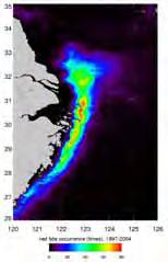


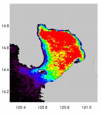
9 3. Satellite-Based Monitoring in the Asian Coastal Seas Detection of phenomena in Asian Waters Application of the developed methodology to the Eastern Asian Waters - Using SeaWiFS Lac data received at the Hong Kong U. Science&Technology - For the period of , 0.01-degree grided images of nlw are processed - Monthly mean nlws are calculated - s are detected through the detection criteria and SS mask (>10mg/l) by Ahn(2002) Red-tides 23 July 2 August, 2001) Occurrence Frequency ( ) 9
 waters: Water color changes are well detected Coastal Case II waters: Not well detected, SS makes significant noise against the present method Background Water Color (Type I) Background")
10 Summary Case-I, A part of Case II (e.g., Osaka bay) waters: Water color changes are well detected Coastal Case II waters: Not well detected, SS makes significant noise against the present method Background Water Color (Type I) Background Water Color (Type-II) Remote sensing strategy Discolored Area - Intensive research for Background water color Type-II - Interdisciplinary and international regional collaboration Traditional In Situ Obs. - Eye Obs.(Ship, Aircraft etc.) - Buoy/ship time series Obs. - Water sampling by ship Red-tide detection Research - Marine biology - Environmental research - Bio-Physical interaction - Bio-Geochemical interaction Operation - Continuous monitoring Ocean Color Remote Sensing - Warning Benefits - Spices identification - Wide-ranging High-resolution (Water sampling and lab. Simultaneous Obs. Process) - Regular High-resolution - Mitigation Temporal Obs. Red-tide related Defects marine environmental - No Obs. Under clouds information Possible contributions from Remote Sensing High-resolution satellite images Chl-a, SS, CDOM, SST, nlw, Solar Radiation etc., Surface winds, Surface currents TSM(mg/L) Tang s SS algorithm 10
 Geostationary Met.")
 Spatial resolution: 1-km Temporal resolution: 6-hour (Resolve")
11 Summer SS distribution and tidal residual current In order to detect the redtide in the type-ii water, we need to understand the SS behavior in the regional seas New Generation SST Ver ) Geostationary Met. Satellite Hourly Infrared AVHRR VIRS Merging by objective analyses TMI SST Microwave SST Cloud free Cloud-free, High Resolution, Quality-Controlled 5 Km Spatial Resolution, Daily SST Product NGSST-C R&D Achievements New Generation SST for Coastal Sea (NGSST-C) Spatial resolution: 1-km Temporal resolution: 6-hour (Resolve Diurnal signal) Coverage: First NEAR-GOOS, extend to the Northern WESTPAC region and the Southern WESTPAC region 11


12 Geostationary Meteorological Satellite : Hourly Solar Radiation Snapshot: 15 September 2006 Mean DSSR in Nov.,
Ocean Remote Sensing (ORS) Programme
 Programme") Ocean Remote Sensing (ORS) Programme Teruhisa KOMATSU Atmosphere and Ocean Research Institute The University of Tokyo W-III 1996 ICAM-P (Huang) Ocean Remote Sensing Programme A history Workshop for ORSP
Ocean Remote Sensing (ORS) Programme Teruhisa KOMATSU Atmosphere and Ocean Research Institute The University of Tokyo W-III 1996 ICAM-P (Huang) Ocean Remote Sensing Programme A history Workshop for ORSP
Long-term Change of Ocean Productivity: A case study in the Bay of Bengal
 Long-term Change of Ocean Productivity: A case study in the Bay of Bengal The 3 rd Asian /12 th Korean-Japan Workshop on Ocean Color Dr.Md.Latifur Rahman Sarker, UTM, Malaysia & RU, Bangladesh & Noor Saadah
Satellite-derived environmental drivers for top predator hotspots
 Satellite-derived environmental drivers for top predator hotspots Peter Miller @PeterM654 South West Marine Ecosystems 2017 21 Apr. 2017, Plymouth University Satellite environmental drivers for hotspots
INFLUENCE OF SEA SURFACE TEMPERATURE ON COASTAL URBAN AREA - CASE STUDY IN OSAKA BAY, JAPAN -
 Proceedings of the Sixth International Conference on Asian and Pacific Coasts (APAC 2011) December 14 16, 2011, Hong Kong, China INFLUENCE OF SEA SURFACE TEMPERATURE ON COASTAL URBAN AREA - CASE STUDY
C M E M S O c e a n C o l o u r S a t e l l i t e P r o d u c t s
 Implemented by C M E M S O c e a n C o l o u r S a t e l l i t e P r o d u c t s This slideshow gives an overview of the CMEMS Ocean Colour Satellite Products Marine LEVEL1 For Beginners- Slides have been
Comparison of chlorophyll concentration in the Bay of Bengal and the Arabian Sea using IRS-P4 OCM and MODIS Aqua
 Indian Journal of Marine Sciences Vol. 39(3), September 2010, pp. 334-340 Comparison of chlorophyll concentration in the Bay of Bengal and the Arabian Sea using IRS-P4 OCM and MODIS Aqua Ramesh P. Singh
Observing System Requirements for the Harmful Algal Bloom Forecast System in the Gulf of Mexico
 Observing System Requirements for the Harmful Algal Bloom Forecast System in the Gulf of Mexico July 2007 Background The Harmful Algal Bloom (HAB) Forecast System provides nowcasts and forecasts of Karenia
Kohei Arai 1 1Graduate School of Science and Engineering Saga University, Saga City, Japan
 (IJARAI) International Journal of Advanced Research in Artificial Intelligence, Vol. 4, No.7, 21 Trend Analysis of Relatively Large Diatoms Which Appear in the Intensive Study Area of the Ariake Sea, Japan
A Time Series of Photo-synthetically Available Radiation at the Ocean Surface from SeaWiFS and MODIS Data
 A Time Series of Photo-synthetically Available Radiation at the Ocean Surface from SeaWiFS and MODIS Data Robert Frouin* a, John McPherson a, Kyozo Ueyoshi a, Bryan A. Franz b a Scripps Institution of
Preparation and dissemination of the averaged maps and fields of selected satellite parameters for the Black Sea within the SeaDataNet project
 Journal of Environmental Protection and Ecology 11, No 4, 1568 1578 (2010) Environmental informatics Preparation and dissemination of the averaged maps and fields of selected satellite parameters for the
Locality of Chlorophyll-A Distribution in the Intensive Study Area of the Ariake Sea, Japan in Winter Seasons based on Remote Sensing Satellite Data
 Vol. 4, No.8, 1 Locality of Chlorophyll-A Distribution in the Intensive Study Area of the Sea, Japan in Winter Seasons based on Remote Sensing Satellite Data Kohei Arai 1 1Graduate School of Science and
Report Benefits and Challenges of Geostationary Ocean Colour Remote Sensing - Science and Applications. Antonio Mannino & Maria Tzortziou
 Report Benefits and Challenges of Geostationary Ocean Colour Remote Sensing - Science and Applications Antonio Mannino & Maria Tzortziou Time & Space Scales of OC Relevant Missions GOCI I & II Geo from
Impacts of Atmospheric Corrections on Algal Bloom Detection Techniques
 1 Impacts of Atmospheric Corrections on Algal Bloom Detection Techniques Ruhul Amin, Alex Gilerson, Jing Zhou, Barry Gross, Fred Moshary and Sam Ahmed Optical Remote Sensing Laboratory, the City College
The Relation between the Red Tide Occurrence and the Sea Water Temperature in South Sea of Korea
 , pp.132-136 http://dx.doi.org/10.14257/astl.2017.145.26 The Relation between the Red Tide Occurrence and the Sea Water Temperature in South Sea of Korea Do-Hyun Hwang 1, Su-Ho Bak 1, Heung-Min Kim 1,
SAWS: Met-Ocean Data & Infrastructure in Support of Industry, Research & Public Good. South Africa-Norway Science Week, 2016
 SAWS: Met-Ocean Data & Infrastructure in Support of Industry, Research & Public Good South Africa-Norway Science Week, 2016 Marc de Vos, November 2016 South Africa: Context http://learn.mindset.co.za/sites/default/files/resourcelib/e
RESEARCH REPORT SERIES
 GREAT AUSTRALIAN BIGHT RESEARCH PROGRAM RESEARCH REPORT SERIES Regional Availability of MODIS Imagery in the Great Australian Bight Ana Redondo Rodriguez1 Edward King2 and Mark Doubell1 SARDI Aquatic Sciences
Forecasting inshore red tide blooms using recent past offshore conditions on the West Florida Shelf
 Forecasting inshore red tide blooms using recent past offshore conditions on the West Florida Shelf Harford 1, Bill, Rykowski 2, MB, Babcock 2 EA, Karnauskas 3, M, Sagarese 3, SR, Walter 3, JF. (1) Cooperative
NOAA Great Lakes CoastWatch Program
 Great Lakes Workshop Series on Remote Sensing of Water Quality May 7-8, 2014 NOAA GLERL, 4840 South State Rd, Ann Arbor, MI NOAA Great Lakes CoastWatch Program CoastWatch is a nationwide National Oceanic
Automated ocean color product validation for the Southern California Bight
 Automated ocean color product validation for the Southern California Bight Curtiss O. Davis a, Nicholas Tufillaro a, Burt Jones b, and Robert Arnone c a College of Earth, Ocean and Atmospheric Sciences,
Quality control methods for KOOS operational sea surface temperature products
 Acta Oceanol. Sin., 2016, Vol. 35, No. 2, P. 11 18 DOI: 10.1007/s13131-016-0807-z http://www.hyxb.org.cn E-mail: hyxbe@263.net Quality control methods for KOOS operational sea surface temperature products
5.5. Coastal and inland waters
 5.5. Coastal and inland waters 5. Atmospheric Correction SeaWiFS and MODIS Experiences Show: High quality ocean color products for the global open oceans (Case-1 waters). Significant efforts are needed
Harmful Algal Blooms (HABs) 5 Applications
 5 Applications") Harmful Algal Blooms (HABs) 5 Applications Richard P. Stumpf NOAA, National Ocean Service HAB occurrences worldwide Image from whoi.edu/redtide HAB applications: short term Management: Monitoring and Response
Harmful Algal Blooms (HABs) 5 Applications Richard P. Stumpf NOAA, National Ocean Service HAB occurrences worldwide Image from whoi.edu/redtide HAB applications: short term Management: Monitoring and Response
Astrid Bracher PHYTOOPTICS group, Climate Sciences, AWI & IUP, University Bremen
 Breakout session "Hyperspectral science and applications for shelf and open ocean processes" Hyperspectral ocean color imagery and applications to studies of phytoplankton ecology Astrid Bracher PHYTOOPTICS
Sentinel 2 Pre-processing Requirements for coastal and inland waters
 Sentinel 2 Pre-processing Requirements for coastal and inland waters K A I S Ø R E NSEN NIVA CARSTEN B R O CKMANN Ecological and chemical classification of water bodies in Norway Water quality - products
OCEAN COLOR REMOTE SENSING
 The 6th Japan-Korea Workshop on OCEAN COLOR REMOTE SENSING 10~11 December 2009 Sapphaire Hall, Guest House, Hanyang University ERICA campus, Ansan, Korea Nagoya University Program 10 December, 2009 09:00~09:20
Currents and Mixing in the Southern Ocean. Sarah Gille
 Currents and Mixing in the Southern Ocean Sarah Gille Scripps Institution of Oceanography and Department of Mechanical and Aerospace Engineering UCSD, La Jolla, CA Where might AVISO gridded fields fall
The pattern determination of sea surface temperature distribution and chlorophyll a in the Southern Caspian Sea using SOM Model
 Iranian Journal of Fisheries Sciences 2()05-4 203 The pattern determination of sea surface temperature distribution and chlorophyll a in the Southern Caspian Sea using SOM Model Downloaded from jifro.ir
LESSON THREE Time, Temperature, Chlorophyll a Does sea surface temperature affect chlorophyll a concentrations?
 STUDENT PAGES LESSON THREE A partnership between California Current Ecosystem Long Term Ecological Research (CCE LTER) and Ocean Institute (OI) Beth Simmons, Education and Outreach Coordinator, CCE LTER,
Estimating the radiation environment in the Great Barrier Reef
 Estimating the radiation environment in the Great Barrier Reef by Itsara Masiri M.Sc. (Physics) Submitted in fulfilment of the requirements for the Degree of Doctor of Philosophy University of Tasmania
Ocean Color Algorithms for the Southern Ocean Constraining the Carbon cycle
 Ocean Color Algorithms for the Southern Ocean Constraining the Carbon cycle Report Breakout Session No. 5 IOCS 2017 Lisbon, Portugal Maria Vernet Scripps Institution of Oceanography, USA Antarctic Fronts:
Inversion of Satellite Ocean-Color Data
 Inversion of Satellite Ocean-Color Data Robert Frouin Scripps Institution of Oceanography La Jolla, California, USA ADEOS-2 AMSR/GLI Workshop,Tsukuba, Japan, 30 January 2007 Collaborators Pierre-Yves Deschamps,
Detecting the Red Edge of absorption in Puget Sound from Satellite measured water-leaving radiance
 Detecting the Red Edge of absorption in Puget Sound from Satellite measured water-leaving radiance Rachel Halfhill University of Washington School of Oceanography The Pacific Northwest Center for Human
Relationship between the mixed layer depth and surface chlorophyll in the Japan/East Sea
 Relationship between the mixed layer depth and surface chlorophyll in the Japan/East Sea Hyun-cheol Kim 1,2, Sinjae Yoo 1 Im Sang Oh 2 1. Korea Ocean Research & Development Institute 2.. Seoul National
Atmospheric correction in presence of sun glint: the POLYMER Algorithm
 Atmospheric correction in presence of sun glint: the POLYMER Algorithm Dominique Jolivet François Steinmetz Pierre-Yves Deschamps Jan 17, 2011 Atelier National Couleur de l'eau - GIS COOC c 2011 Atmospheric
Operation and Calibration Status of GOCI
 2016 GSICS Data & Research Working Groups Meeting @ JAXA, Tsukuba, 29. Feb. 2016 Operation and Calibration Status of GOCI Seongick CHO Korea Ocean Satellite Center, Korea Institute of Ocean Science and
an accessible interface to marine environmental data Russell Moffitt
 an accessible interface to marine environmental data Russell Moffitt The Atlas Project GOAL: To provide a single point of access to oceanographic and environmental data for use by marine resource researchers,
Exploring the Temporal and Spatial Dynamics of UV Attenuation and CDOM in the Surface Ocean using New Algorithms
 Exploring the Temporal and Spatial Dynamics of UV Attenuation and CDOM in the Surface Ocean using New Algorithms William L. Miller Department of Marine Sciences University of Georgia Athens, Georgia 30602
Ocean front maps for integrating dynamic thermal, colour and salinity features Peter Miller and Weidong Xu
 Ocean front maps for integrating dynamic thermal, colour and salinity features Peter Miller and Weidong Xu 44 th International Liège Colloquium on Ocean Dynamics: Remote sensing of colour, temperature
SEAWIFS VALIDATION AT THE CARIBBEAN TIME SERIES STATION (CATS)
") SEAWIFS VALIDATION AT THE CARIBBEAN TIME SERIES STATION (CATS) Jesús Lee-Borges* and Roy Armstrong Department of Marine Science, University of Puerto Rico at Mayagüez, Mayagüez, Puerto Rico 00708 Fernando
SEAWIFS VALIDATION AT THE CARIBBEAN TIME SERIES STATION (CATS) Jesús Lee-Borges* and Roy Armstrong Department of Marine Science, University of Puerto Rico at Mayagüez, Mayagüez, Puerto Rico 00708 Fernando
The Climatology of Clouds using surface observations. S.G. Warren and C.J. Hahn Encyclopedia of Atmospheric Sciences.
 The Climatology of Clouds using surface observations S.G. Warren and C.J. Hahn Encyclopedia of Atmospheric Sciences Gill-Ran Jeong Cloud Climatology The time-averaged geographical distribution of cloud
Tidal front around the Hainan Island, northwest of the South China Sea
 JOURNAL OF GEOPHYSICAL RESEARCH, VOL. 108, NO. C11, 3342, doi:10.1029/2003jc001883, 2003 Tidal front around the Hainan Island, northwest of the South China Sea Jianyu Y. Hu, 1 Hiroshi Kawamura, and Danling
Surface Anomalies Prior to Earthquakes
 Surface Anomalies Prior to Earthquakes Habibeh Valizadeh, Shattri B. Mansor Husaini Omar and Farid Azad Department of Civil Engineering Universiti Putra Malaysia Serdang, Selangor Malaysia shattri@eng.upm.edu.my
Remote sensing of coral reef and Coral Reef bleaching in the South China Sea
 Remote sensing of coral reef and Coral Reef bleaching in the South China Sea (Lingzis) 唐丹玲 (Tang Dynasty of China) Research Center of Remote Sensing of Marine Ecology/Environment (REMEE) South China Sea
Update on SCOPE-Nowcasting Pilot Project Real Time Ocean Products Suman Goyal Scientist-E
 Update on SCOPE-Nowcasting Pilot Project Real Time Ocean Products Suman Goyal Scientist-E 19-22 Nov 2013 SCOPE-Nowcasting-1 Agenda Item 5 Pilot Projects Overview Users /Clients User requirements Product
Objective Determination of Feature Resolution in an SST Analysis. Richard W. Reynolds (NOAA, CICS) Dudley B. Chelton (Oregon State University)
 Dudley B. Chelton (Oregon State University)") Objective Determination of Feature Resolution in an SST Analysis Richard W. Reynolds (NOAA, CICS) Dudley B. Chelton (Oregon State University) 1 What is an Analysis? An analysis is a field produced on a
Objective Determination of Feature Resolution in an SST Analysis Richard W. Reynolds (NOAA, CICS) Dudley B. Chelton (Oregon State University) 1 What is an Analysis? An analysis is a field produced on a
Egypt-NOAA Cooperation: Advancing our Environmental Science, Technology, and Education
 Egypt-NOAA Cooperation: Advancing our Environmental Science, Technology, and Education T. G. Onsager NOAA Space Weather Prediction Center and NWS International Activities Office (one-year detail) Terry.Onsager@noaa.gov
Air sea satellite flux datasets and what they do (and don't) tell us about the air sea interface in the Southern Ocean
 tell us about the air sea interface in the Southern Ocean") Air sea satellite flux datasets and what they do (and don't) tell us about the air sea interface in the Southern Ocean Carol Anne Clayson Woods Hole Oceanographic Institution Southern Ocean Workshop Seattle,
Air sea satellite flux datasets and what they do (and don't) tell us about the air sea interface in the Southern Ocean Carol Anne Clayson Woods Hole Oceanographic Institution Southern Ocean Workshop Seattle,
Current Variation in the Sea near the Mouth of Suruga Bay*
 fl Journal of the Oceanographical Vol.40, pp.193 to 198, 1984 Society of Japan Current Variation in the Sea near the Mouth of Suruga Bay* Hideo Inabat Abstract: In order to investigate the circulation
Coastal Characterization Using EO-1 Hyperion Data
 Coastal Characterization Using EO-1 Hyperion Data Dr. Hsiao-hua K. Burke EO-1 SVT Meeting 18-21 November 2002 Sponsor: NOAA NESDIS GOES 2002-1 Channel Positions of Various Ocean- Color Sensors, 1978-2000*
Seasonal and spatial distribution of chlorophyll-a concentrations and water conditions in the Gulf of Tonkin, South China Sea
 Remote Sensing of Environment 85 (2003) 475 483 www.elsevier.com/locate/rse Seasonal and spatial distribution of chlorophyll-a concentrations and water conditions in the Gulf of Tonkin, South China Sea
DBCP 2012 SCIENTIFIC AND TECHNICAL WORKSHOP Fremantle, Australia, 2 October 2012 SALIENT FEATURES OF INDIAN DEEP SEA INSTRUMENTED BUOY NETWORK IN THE
 DBCP 2012 SCIENTIFIC AND TECHNICAL WORKSHOP Fremantle, Australia, 2 October 2012 SALIENT FEATURES OF INDIAN DEEP SEA INSTRUMENTED BUOY NETWORK IN THE BAY OF BENGAL R. Venkatesan, Arul Muthiah, Simi Mathew
Authors of abstract. Pat Fitzpatrick Jessie Kastler Frank Hernandez Carla Culpepper Candace Bright. But whole CONCORDE team contributed to results
 Authors of abstract Pat Fitzpatrick Jessie Kastler Frank Hernandez Carla Culpepper Candace Bright MSU USM USM USM USM But whole CONCORDE team contributed to results Outline of talk Field program information
GODAE Ocean View Activities in JMA (and Japan)
") GOVST VIII, Nov. 6 th, 2017, Bergen, Norway GODAE Ocean View Activities in JMA (and Japan) Yosuke Fujii 1, Norihisa Usui 1, Takahiro Toyoda 1, Nariaki Hirose 1, Hiromichi Igarashi 2, and Japan GODAE group
GOVST VIII, Nov. 6 th, 2017, Bergen, Norway GODAE Ocean View Activities in JMA (and Japan) Yosuke Fujii 1, Norihisa Usui 1, Takahiro Toyoda 1, Nariaki Hirose 1, Hiromichi Igarashi 2, and Japan GODAE group
The Coastal Ocean Applications and Science Team (COAST): Science Support for a Geostationary Ocean Color Imager for Coastal Waters
: Science Support for a Geostationary Ocean Color Imager for Coastal Waters") The Coastal Ocean Applications and Science Team (COAST): Science Support for a Geostationary Ocean Color Imager for Coastal Waters PIs: Curt Davis and Mark Abbott NOAA Technical Contact: Paul Menzel, NOAA/STAR.
The Coastal Ocean Applications and Science Team (COAST): Science Support for a Geostationary Ocean Color Imager for Coastal Waters PIs: Curt Davis and Mark Abbott NOAA Technical Contact: Paul Menzel, NOAA/STAR.
JGOFS Open Science Conference. JGOFS Open Science Conference 5-88 May 2003 Washington, D.C.
 5-88 May 23 Washington, D.C. Constraining Fluxes at the Top: Advances in Quantifying Air-Sea Carbon Dioxide Fluxes during the JGOFS Decade Speaker: Rik Wanninkhof NOAA/AOML Commentator: Richard A. Feely
SPATIAL CHARACTERISTICS OF THE SURFACE CIRCULATION AND WAVE CLIMATE USING HIGH-FREQUENCY RADAR
 SPATIAL CHARACTERISTICS OF THE SURFACE CIRCULATION AND WAVE CLIMATE USING HIGH-FREQUENCY RADAR Apisit Kongprom,Siriluk Prukpitikul, Varatip Buakaew, Watchara Kesdech, and Teerawat Suwanlertcharoen Geo-Informatics
COVERAGE-Sargasso Sea
 COVERAGE-Sargasso Sea A Collaborative Project between NASA and the Sargasso Sea Commission Dr. Vardis Tsontos Dr. Jorge Vazquez NASA Jet Propulsion Laboratory, California Institute of Technology UN-HQ
Coastal Water Quality Monitoring in Cyprus using Satellite Remote Sensing
 Coastal Water Quality Monitoring in Cyprus using Satellite Remote Sensing D. G. Hadjimitsis 1*, M.G. Hadjimitsis 1, 2, A. Agapiou 1, G. Papadavid 1 and K. Themistocleous 1 1 Department of Civil Engineering
Understanding Near-Surface and In-cloud Turbulent Fluxes in the Coastal Stratocumulus-topped Boundary Layers
 Understanding Near-Surface and In-cloud Turbulent Fluxes in the Coastal Stratocumulus-topped Boundary Layers Qing Wang Meteorology Department, Naval Postgraduate School Monterey, CA 93943 Phone: (831)
Bugs in JRA-55 snow depth analysis
 14 December 2015 Climate Prediction Division, Japan Meteorological Agency Bugs in JRA-55 snow depth analysis Bugs were recently found in the snow depth analysis (i.e., the snow depth data generation process)
Recent Data Assimilation Activities at Environment Canada
 Recent Data Assimilation Activities at Environment Canada Major upgrade to global and regional deterministic prediction systems (now in parallel run) Sea ice data assimilation Mark Buehner Data Assimilation
Chlorophyll-a, Phycocyanin and Phytoplankton type products
 Chlorophyll-a, Phycocyanin and Phytoplankton type products Mariano Bresciani, Monica Pinardi, Claudia Giardino CNR IREA bresciani.m@irea.cnr.it Aims Implementation of algorithms dedicated to phytoplankton's
Seasonal and mesoscale variability of phytoplankton in the Arabian Sea. from satellite observations to models
 Seasonal and mesoscale variability of phytoplankton in the Arabian Sea from satellite observations to models Marina Lévy NIO Winter school, Feb 2015 LOCEAN-IPSL, France 1 Introduction Arabian Sea Chlorophyll
Monitoring Sea Surface temperature change at the Caribbean Sea, using AVHRR images. Y. Santiago Pérez, and R. Mendez Yulfo
 Monitoring Sea Surface temperature change at the Caribbean Sea, using AVHRR images. Y. Santiago Pérez, and R. Mendez Yulfo Department of Geology, University of Puerto Rico Mayagüez Campus, P.O. Box 9017,
SATELLITE DATA COLLECTION BY THE UPRM-TCESS SPACE INFORMATION LABORATORY
 SATELLITE DATA COLLECTION BY THE UPRM-TCESS SPACE INFORMATION LABORATORY Visita a la Estación De Satélites De UPRM En el CID 16 sep. 4:30 pm Nos reuniremos al frente del CID. CID L-BAND ANTENNA Orbview
Non-meteorological Applications for Next Generation Geostationary Meteorological Satellites
 Non-meteorological Applications for Next Generation Geostationary Meteorological Satellites Toshiyuki KURINO Satellite Program Division Japan Meteorological Agency Topics Advanced GEO for Earth Observation
Detection of ship NO 2 emissions over Europe from satellite observations
 Detection of ship NO 2 emissions over Europe from satellite observations Huan Yu DOAS seminar 24 April 2015 Ship Emissions to Atmosphere Reporting Service (SEARS project) Outline Introduction Shipping
Vicarious calibration of GLI by global datasets. Calibration 5th Group Hiroshi Murakami (JAXA EORC)
") Vicarious calibration of GLI by global datasets Calibration 5th Group Hiroshi Murakami (JAXA EORC) ADEOS-2 PI workshop March 2004 1 0. Contents 1. Background 2. Operation flow 3. Results 4. Temporal change
Vicarious calibration of GLI by global datasets Calibration 5th Group Hiroshi Murakami (JAXA EORC) ADEOS-2 PI workshop March 2004 1 0. Contents 1. Background 2. Operation flow 3. Results 4. Temporal change
Annex VI-1. Draft National Report on Ocean Remote Sensing in China. (Reviewed by the Second Meeting of NOWPAP WG4)
") UNEP/NOWPAP/CEARAC/WG4 2/9 Page1 Draft National Report on Ocean Remote Sensing in China (Reviewed by the Second Meeting of NOWPAP WG4) UNEP/NOWPAP/CEARAC/WG4 2/9 Page1 1. Status of RS utilization in marine
UNEP/NOWPAP/CEARAC/WG4 2/9 Page1 Draft National Report on Ocean Remote Sensing in China (Reviewed by the Second Meeting of NOWPAP WG4) UNEP/NOWPAP/CEARAC/WG4 2/9 Page1 1. Status of RS utilization in marine
EXTRACTION OF THE DISTRIBUTION OF YELLOW SAND DUST AND ITS OPTICAL PROPERTIES FROM ADEOS/POLDER DATA
 EXTRACTION OF THE DISTRIBUTION OF YELLOW SAND DUST AND ITS OPTICAL PROPERTIES FROM ADEOS/POLDER DATA Takashi KUSAKA, Michihiro KODAMA and Hideki SHIBATA Kanazawa Institute of Technology Nonoichi-machi
Ocean Colour Remote Sensing in Turbid Waters. Lecture 2: Introduction to computer exercise #1 The Colour of Water.
 Ocean Colour Remote Sensing in Turbid Waters Lecture 2: Introduction to computer exercise #1 The Colour of Water by Kevin Ruddick Overview of this lecture Objective: introduce the HYPERTEACH ocean colour
Life cycle strategies and occurrences of red tides of Heterosigma akashiwo and Chattonella spp. in temperate coastal sea
 Life cycle strategies and occurrences of red tides of Heterosigma akashiwo and Chattonella spp. in temperate coastal sea Ichiro Imai (Kyoto University), Shigeru Itakura, Mineo Yamaguchi Global distribution
CHAPTER 2 DATA AND METHODS. Errors using inadequate data are much less than those using no data at all. Charles Babbage, circa 1850
 CHAPTER 2 DATA AND METHODS Errors using inadequate data are much less than those using no data at all. Charles Babbage, circa 185 2.1 Datasets 2.1.1 OLR The primary data used in this study are the outgoing
Minutes of the First Meeting. of the IOCCG Working Group. L1 Requirements for Ocean-Colour Remote Sensing. April 20-21, 2010
 Minutes of the First Meeting of the IOCCG Working Group L1 Requirements for Ocean-Colour Remote Sensing April 20-21, 2010 Bethesda, Maryland (Washington, D.C.), USA Participants: - Charles R. McClain (chair,
Applications of an ensemble Kalman Filter to regional ocean modeling associated with the western boundary currents variations
 Applications of an ensemble Kalman Filter to regional ocean modeling associated with the western boundary currents variations Miyazawa, Yasumasa (JAMSTEC) Collaboration with Princeton University AICS Data
Satellite Oceanography and Applications 1: Introduction, SST, Ocean color
 Satellite Oceanography and Applications 1: Introduction, SST, Ocean color Ebenezer Nyadjro US Naval Research Lab RMU Summer Program (AUGUST 24-28, 2015) Objectives/Goals To know the basic methods of ocean
The low water-leaving radiances phenomena around the Yangtze River Estuary
 The low water-leaving radiances phenomena around the Yangtze River Estuary He Xianqiang* a, Bai Yan a, Mao Zhihua a, Chen Jianyu a a State Key Laboratory of Satellite Ocean Environment Dynamics, Second
Comparison between MERIS and GOCI in regional seas around Korea
 Comparison between MERIS and GOCI in regional seas around Korea Young-Je Park, Yu-Hwan Ahn, Jung-Mi Yoo KOSC staff Korea Ocean Satellite Center (KOSC), Korea Ocean Research and Development Institute (KODI)
Seasonal Simulaions of a coupled ice-ocean model in the Bohai Sea and North Yellow Sea
 Seasonal Simulaions of a coupled ice-ocean model in the Bohai Sea and North Yellow Sea Yu LIU,Qinzheng LIU,Jie Su*, Shan BAI,Maoning Tang National Marine Environmental Forecasting Center * Ocean University
A proposal for a new IOCCG working group. Theme: ocean colour observations from the geostationary orbit. Proposed by David Antoine
 A proposal for a new IOCCG working group Theme: ocean colour observations from the geostationary orbit Proposed by David Antoine IOCCG working group Ocean colour from the geostationary orbit Plan - Motivations
MERSEA Marine Environment and Security for the European Area
 MERSEA Marine Environment and Security for the European Area Development of a European system for operational monitoring and forecasting of the ocean physics, biogeochemistry, and ecosystems, on global
Potential of profiling floats to enhance NASA s mission
 Potential of profiling floats to enhance NASA s mission Emmanuel Boss University of Maine Outline: What are profiling floats? Studies to date involving optics and profiling floats. Apex float 5. Collaborators:
Detecting Chlorophyll a Concentration and Bloom Patterns at Upwelling Area in South Central Vietnam by High Resolution Multi-satellite Data
 Journal of Environmental Science and Engineering A 4 (2015) 215-224 doi:10.17265/2162-5298/2015.05.001 D DAVID PUBLISHING Detecting Chlorophyll a Concentration and Bloom Patterns at Upwelling Area in South
SATELLITE-BASED OBSERVATION OF CHLOROPHYLL-A CONCENTRATION IN THE UPPER GULF OF THAILAND
 SATELLITE-BASED OBSERVATION OF CHLOROPHYLL-A CONCENTRATION IN THE UPPER GULF OF THAILAND Prasarn Intacharoen 1,2, Songkot Dasananda 1, Anukul Buranapratheprat 2 1 School of Remote Sensing, Institute of
RESEARCH EDGE SPECTRAL REMOTE SENSING OF THE COAST. Karl Heinz Szekielda
 Research Edge Working Paper Series, no. 8 p. 1 RESEARCH EDGE SPECTRAL REMOTE SENSING OF THE COAST Karl Heinz Szekielda City University of New York Fulbright Scholar at, Nassau, The Bahamas Email: karl.szekielda@gmail.com
Carsten Brockmann, Ana Ruescas, Simon Pinnock CoastColour Team: BC D, HZG D, PML UK, RBINS B, LISE F, FCUL P COASTCOLOUR SPOT 4 TAKE 5
 Carsten Brockmann, Ana Ruescas, Simon Pinnock CoastColour Team: BC D, HZG D, PML UK, RBINS B, LISE F, FCUL P COASTCOLOUR SPOT 4 TAKE 5 CoastColour CoastColour is providing ocean colour products for coastal
Estimation of Insolation over the Pacific Ocean off the Sanriku Coast
 Journal of Oceanography, Vol. 54, pp. 457 to 464. 1998 Estimation of Insolation over the Pacific Ocean off the Sanriku Coast HIROSHI KAWAMURA 1,4, SHUICHI TANAHASHI 2,4 and TOMOYUKI TAKAHASHI 3,4 1 Center
GEOSC/METEO 597K Kevin Bowley Kaitlin Walsh
 GEOSC/METEO 597K Kevin Bowley Kaitlin Walsh Timeline of Satellites ERS-1 (1991-2000) NSCAT (1996) Envisat (2002) RADARSAT (2007) Seasat (1978) TOPEX/Poseidon (1992-2005) QuikSCAT (1999) Jason-2 (2008)
Satellite Characterization of Bio-Optical and Thermal Variability in the Japan/East Sea
 Satellite Characterization of Bio-Optical and Thermal Variability in the Japan/East Sea Robert Arnone Ocean Optics Section Code 7333 Naval Research Laboratory Stennis Space Center, MS 39529 phone: (228)
Remote Sensing for Sea Surface Monitoring. Cristina Bentz PETROBRAS R&D Center Environment Assessment and Monitoring
 Remote Sensing for Sea Surface Monitoring Cristina Bentz PETROBRAS R&D Center Environment Assessment and Monitoring cris@petrobras.com.br Overview Introduction Orbital sea surface monitoring: Scope and
Ocean Observation from Haiyang Satellites:
 SPACE SCIENCE ACTIVITIES IN CHINA Ocean Observation from Haiyang Satellites: 2012 2014 AUTHORS JIANG Xingwei LIN Mingsen National Satellite Ocean Application Service, Beijing 100081 ABSTRACT During 2012
A state of the art and user driven Copernicus service Physics and Biogeochemistry
 C M E M S P r e s e n t a n d F u t u r e R e q u i r e m e n t s f o r I n - S i t u a n d S a t e l l i t e O b s e r v a t i o n s Antonio REPPUCCI; Pierre Yves LE TRAON Mercator Ocean International
Seasonal Climate Outlook for South Asia (June to September) Issued in May 2014
 Issued in May 2014") Ministry of Earth Sciences Earth System Science Organization India Meteorological Department WMO Regional Climate Centre (Demonstration Phase) Pune, India Seasonal Climate Outlook for South Asia (June
Ministry of Earth Sciences Earth System Science Organization India Meteorological Department WMO Regional Climate Centre (Demonstration Phase) Pune, India Seasonal Climate Outlook for South Asia (June
7 December 2016 Tokyo Climate Center, Japan Meteorological Agency
 Summary of the 2016 Asian Summer Monsoon 7 December 2016 Tokyo Climate Center, Japan Meteorological Agency This report summarizes the characteristics of the surface climate and atmospheric/oceanographic
Multivariate time-series forecasting of the NE Arabian Sea Oil Sardine fishery using satellite covariates
 Multivariate time-series forecasting of the NE Arabian Sea Oil Sardine fishery using satellite covariates Eli Holmes 1, Nimit Kumar 2, Sourav Maity 2, B.R Smitha 3, Sherine Cubelio 3, Cara Wilson 4, Narayanane
P1.34 MULTISEASONALVALIDATION OF GOES-BASED INSOLATION ESTIMATES. Jason A. Otkin*, Martha C. Anderson*, and John R. Mecikalski #
 P1.34 MULTISEASONALVALIDATION OF GOES-BASED INSOLATION ESTIMATES Jason A. Otkin*, Martha C. Anderson*, and John R. Mecikalski # *Cooperative Institute for Meteorological Satellite Studies, University of
APPLICATIONS WITH METEOROLOGICAL SATELLITES. W. Paul Menzel. Office of Research and Applications NOAA/NESDIS University of Wisconsin Madison, WI
 APPLICATIONS WITH METEOROLOGICAL SATELLITES by W. Paul Menzel Office of Research and Applications NOAA/NESDIS University of Wisconsin Madison, WI July 2004 Unpublished Work Copyright Pending TABLE OF CONTENTS
GEO New Mission and Synergy Joo-Hyung Ryu
 GEO New Mission and Synergy Joo-Hyung Ryu Korea Ocean Satellite Center Korea Institute Ocean Sciences & Technology GEMS GOCI-II GOCI Development : KARI & KIOST Cooperation Development Payload system -
Evaluation of Satellite and Reanalysis Products of Downward Surface Solar Radiation over East Asia
 International Workshop on Land Use/Cover Changes and Air Pollution in Asia August 4-7th, 2015, Bogor, Indonesia Evaluation of Satellite and Reanalysis Products of Downward Surface Solar Radiation over
Japanese Programs on Space and Water Applications
 Japanese Programs on Space and Water Applications Tamotsu IGARASHI Remote Sensing Technology Center of Japan June 2006 COPUOS 2006 Vienna International Centre Water-related hazards/disasters may occur