Coastal Characterization Using EO-1 Hyperion Data
|
|
|
- Angel Fleming
- 5 years ago
- Views:
Transcription

1 Coastal Characterization Using EO-1 Hyperion Data Dr. Hsiao-hua K. Burke EO-1 SVT Meeting November 2002 Sponsor: NOAA NESDIS GOES

2 Channel Positions of Various Ocean- Color Sensors, * For a multi spectral sensor Many spectral bands are identified for various applications Selection of band location and width are also important HSI provides contiguous spectral coverage and thus comprehensive information content GOES * IOCCG Report #1
3 Why HSI for Coastal Characterization? Most ocean feature algorithms are semi-empirical retrievals, HSI has all bands to: Provide legacy with previous sensors Explore new information Coastal features are more complex than those of deep (open) ocean Coupled effects best resolved with HSI With contiguous spectral coverage, atmospheric compensation can be done with more accuracy and confidence Most ocean characterization algorithms utilize water-leaving radiance Aerosol effect most pronounced in shortwave visible where ocean color measurements are made GOES
 Information contents are different HSI allows adaptive band selection: no more competing requirements 0.52-0.70 µm 0.52-0.80 µm 2. MSI vs.")
4 Illustration of Enhanced Information Content from MSI to HSI Two examples shown 1. Two similar broad bands ( and um) Information contents are different HSI allows adaptive band selection: no more competing requirements µm µm 2. MSI vs. HSI (EO-1 ALI and Hyperion) More feature information available despite lower SNR of Hyperion GOES ALI Hyperion
5 Principal Components Analysis (PCA) - Reduction of HSI Dimensionality - Principal Components Transform A linear transform that projects data onto an orthogonal set of basis functions that are eigenvectors of the spectral covariance matrix: Covariance Matrix: Σ = E{(X - M)(X - M) Τ } Eigenvectors and Eigenvalues: Σ e = Λ e Apply to Image Cube: PC (x,y) = e Τ X (x,y) Standard multivariate analysis technique Dimensionality reduction Contrast enhancement Anomaly detection Separates significant scene information from noise dominated components large eigenvalues -> components that greatly contribute to overall variance small eigenvalues -> noise dominated components GOES

6 Principal Components Analysis (PCA) - Reduction of HSI Dimensionality - Cont. Eigenstructure Computed from example imagery Eigenvalues Eigenvectors PC: Indicative of the amount of spectral variability represented by corresponding eigenvector large values! scene components that greatly contribute to overall variance small values! noise dominated components intermediate values "? anomalous features GOES Groups spectral channels that have similar contributions to overall spectral variability Ordered by decreasing eigenvalue Can help to identify important spectral regions Full Full spectral information can can be be recovered
7 An Illustration: Similar Bands, Different Information Content Broad Images µm µm GOES Images simulated by integrating (18 & 28) AVIRIS HSI bands Animation to follow


8 An Illustration: Similar Bands, Different Information Content Broad PC Images µm µm GOES
9 Cascaded Principal Component Analysis Minimum Noise Fraction (MNF) Transform Principal Components Transformation (PCT) Covariance Matrix: Σ = Ε {(Χ Χ m )(Χ Χ m ) Τ } Eigenvectors and Eigenvalues: Σ = Φ Λ Φ Τ MNF: Two cascaded PCTs The first based on estimated noise covariance Band-to-band de-correlated noise in transformed data The second PCT on noise-whitened data Unit noise variance Result: Image information aggregated in leading components Noise segregated in trailing components Inherent dimensionality of HSI data determined GOES
 Band Pan MS-1 MS-1 MS-2 MS-3 MS-4 MS-4 MS-5 MS-5 MS-7 Wavelength GSD (m) (nm) 480-690 10 433-453 30 450-515 30 525-605 30 630-690")
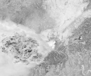
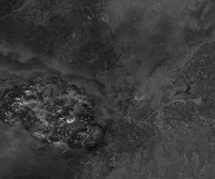
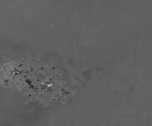
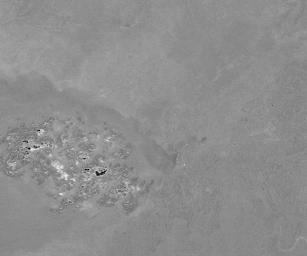
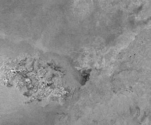
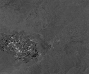
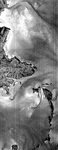
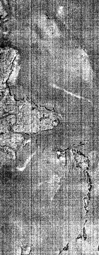
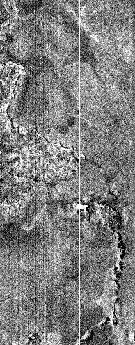
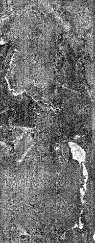
10 EO-1 Data from Chesapeake Bay Selected area (~6 x 15 km 2 ), 0.43 to 0.93 µm only ALI 200 samples/line 512 lines 6 bands (MS-1,1,2,3,4,4 ) Band Pan MS-1 MS-1 MS-2 MS-3 MS-4 MS-4 MS-5 MS-5 MS-7 Wavelength GSD (m) (nm) GOES Hyperion 194 samples/line 496 lines 50 bands ( µm)
11 MNF Bands 1 & 2 ALI MNF Band 1 Hyperion MNF Band 1 ALI MNF Band 2 Hyperion MNF Band 2 GOES Animation to follow


12 MNF Components for ALI and Hyperion ALI MNF GOES Hyperion MNF More feature information available despite lower SNR of Hyperion

13 Additional Advantages: Full Spectral and Color Exploitation Abundant spectral information in HSI offers potential for Comprehensive feature extraction Anomaly detection Often new phenomena occur, full color coverage allows for new investigation and data exploitation Red Tide observed recently along NSW coast of Australia Suspected algae outbreak The effect turns to eerie green at night GOES


14 Location of EO-1 Data from Chesapeake Bay GOES
15 Hyperion and ALI Radiance Point Spectra Radiance W/m 2 -sr-µm) GOES Wavelength (µm)
16 Hyperion and ALI TOA Reflectance Point Spectra Reflectance GOES Wavelength (µm)
17 Atmospheric Compensation: ATREM Highlights Physical radiative transfer model (Gao, et al., 1993) Originally designed for AVIRIS Mature algorithm, used extensively by remote sensing community Simple interface and fast execution Required input: Model atmosphere Haze/aerosol conditions Solar and viewing geometry Sensor platform and characteristics Conducts column water vapor retrieval based on ratioing the absorption and wing regions of two weak water vapor absorption bands (0.94 and 1.14 µm) Constructs pixel-by-pixel reflectance spectra based on derived total spectral transmittance GOES
18 Schematic Flow of ATREM (Atmospheric REMoval Program) Input: Sensor info SZA, Aerosol 6S RT Code w/ Std Atm Constituents LUT w/ H 2 O (0-10 cm) ρ a, S, T(θ s ), T(θ u ) Image Radiance Cube TOA Solar Irr Apparent Reflectance 3-Ch H 2 O 0.94 & 1.14µm Average Col. H 2 O Pixel-by-Pixel Tg TOA: TOA: Top Top of of Atmosphere Atmosphere T(θ T(θ s ): s ): Downward Downward scattering scattering transmittance transmittance LUT: LUT: Look-up Look-up Table Table T(θ T(θ u ): u ): Upward Upward scattering scattering transmittance transmittance ρ a : a : Atm Atm Reflectance Reflectance Tg: Tg: Total Total transmittance transmittance S: S: Atm Atm Spherical Spherical Albedo Albedo 6S: 6S: Second Second Simulation Simulation of of the the Satellite Satellite Signal Signal in in the the Solar Solar Spectrum Spectrum Surface Reflectance Cube GOES


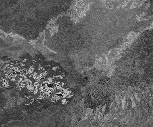
19 Sea Surface Reflectance (ATREM) 478nm 600nm 763nm 478nm 600nm 763nm GOES


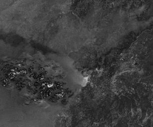
20 Chlorophyll-a Calculations (HYPERION) 478nm 447nm 478nm 600nm 488nm 600nm Line Line nm 763nm 550nm Line Line nm7 Line nm Line 400 Line 475 Line 400 Line Range: 2.1 to 3.6 mg/m3 Calculated using SeaWIFS OC4 GOES

 Initial chlorophyll retrieval from Hyperion")
21 Supporting Data Chesapeake Bay Remote Sensing Program CBRSP 2/19/02 SeaWIFS Data averaged for the week 2/18/02-2/25/02 Chlorophyll-a immediately inside the Bay is between 2 to 4 mg/m3. EO-1 data area is shown in red box GOES to 4.0 mg/m3 (Level 3 calculations use OC4 algorithm) Initial chlorophyll retrieval from Hyperion data demonstrated: good agreement with published data
22 Recommendations for Future EO-1 Data Collection Select coastal regions of interest Conduct multiple collections to observe temporal changes Assemble (or collect) ground truth (ancillary/auxiliary) data for validation Comprehensive utility assessment of HSI to coastal characterization GOES
HICO Calibration and Atmospheric Correction
 HICO Calibration and Atmospheric Correction Curtiss O. Davis College of Earth Ocean and Atmospheric Sciences Oregon State University, Corvallis, OR, USA 97331 cdavis@coas.oregonstate.edu Oregon State Introduction
Hyperspectral Atmospheric Correction
 Hyperspectral Atmospheric Correction Bo-Cai Gao June 2015 Remote Sensing Division Naval Research Laboratory, Washington, DC USA BACKGROUND The concept of imaging spectroscopy, or hyperspectral imaging,
HICO OSU Website and Data Products
 HICO OSU Website and Data Products Curtiss O. Davis College of Earth Ocean and Atmospheric Sciences Oregon State University, Corvallis, OR, USA 97331 cdavis@coas.oregonstate.edu Oregon State Introduction
5.5. Coastal and inland waters
 5.5. Coastal and inland waters 5. Atmospheric Correction SeaWiFS and MODIS Experiences Show: High quality ocean color products for the global open oceans (Case-1 waters). Significant efforts are needed
BAYESIAN METHODOLOGY FOR ATMOSPHERIC CORRECTION OF PACE OCEAN-COLOR IMAGERY
 BAYESIAN METHODOLOGY FOR ATMOSPHERIC CORRECTION OF PACE OCEAN-COLOR IMAGERY Robert Frouin, SIO/UCSD Topics 1. Estimating phytoplankton fluorescence and ocean Raman scattering from OCI super sampling in
Bayesian Methodology for Atmospheric Correction of PACE Ocean-Color Imagery
 Bayesian Methodology for Atmospheric Correction of PACE Ocean-Color Imagery Robert Frouin, PI Scripps Institution of Oceanography, University of California San Diego, La Jolla, USA Bruno Pelletier, Co-I
Estimation of ocean contribution at the MODIS near-infrared wavelengths along the east coast of the U.S.: Two case studies
 GEOPHYSICAL RESEARCH LETTERS, VOL. 32, L13606, doi:10.1029/2005gl022917, 2005 Estimation of ocean contribution at the MODIS near-infrared wavelengths along the east coast of the U.S.: Two case studies
MERIS, A-MODIS, SeaWiFS, AATSR and PARASOL over the Salar de Uyuni March 2006 MAVT 2006 Marc Bouvet, ESA/ESTEC
 MERIS, A-MODIS, SeaWiFS, AATSR and PARASOL over the Salar de Uyuni Plan of the presentation 1. Introduction : from absolute vicarious calibration to radiometric intercomparison 2. Intercomparison at TOA
GEOG 4110/5100 Advanced Remote Sensing Lecture 15
 GEOG 4110/5100 Advanced Remote Sensing Lecture 15 Principal Component Analysis Relevant reading: Richards. Chapters 6.3* http://www.ce.yildiz.edu.tr/personal/songul/file/1097/principal_components.pdf *For
Inversion of Satellite Ocean-Color Data
 Inversion of Satellite Ocean-Color Data Robert Frouin Scripps Institution of Oceanography La Jolla, California, USA ADEOS-2 AMSR/GLI Workshop,Tsukuba, Japan, 30 January 2007 Collaborators Pierre-Yves Deschamps,
HYPERSPECTRAL IMAGING
 1 HYPERSPECTRAL IMAGING Lecture 9 Multispectral Vs. Hyperspectral 2 The term hyperspectral usually refers to an instrument whose spectral bands are constrained to the region of solar illumination, i.e.,
Astrid Bracher PHYTOOPTICS group, Climate Sciences, AWI & IUP, University Bremen
 Breakout session "Hyperspectral science and applications for shelf and open ocean processes" Hyperspectral ocean color imagery and applications to studies of phytoplankton ecology Astrid Bracher PHYTOOPTICS
Impacts of Atmospheric Corrections on Algal Bloom Detection Techniques
 1 Impacts of Atmospheric Corrections on Algal Bloom Detection Techniques Ruhul Amin, Alex Gilerson, Jing Zhou, Barry Gross, Fred Moshary and Sam Ahmed Optical Remote Sensing Laboratory, the City College
Radiation in the atmosphere
 Radiation in the atmosphere Flux and intensity Blackbody radiation in a nutshell Solar constant Interaction of radiation with matter Absorption of solar radiation Scattering Radiative transfer Irradiance
APPLICATIONS WITH METEOROLOGICAL SATELLITES. W. Paul Menzel. Office of Research and Applications NOAA/NESDIS University of Wisconsin Madison, WI
 APPLICATIONS WITH METEOROLOGICAL SATELLITES by W. Paul Menzel Office of Research and Applications NOAA/NESDIS University of Wisconsin Madison, WI July 2004 Unpublished Work Copyright Pending TABLE OF CONTENTS
Comparison of aerosol radiative forcing over the Arabian Sea and the Bay of Bengal
 Advances in Space Research 33 (2004) 1104 1108 www.elsevier.com/locate/asr Comparison of aerosol radiative forcing over the Arabian Sea and the Bay of Bengal S. Dey a, S. Sarkar b, R.P. Singh a, * a Department
The Spectral Radiative Effects of Inhomogeneous Clouds and Aerosols
 The Spectral Radiative Effects of Inhomogeneous Clouds and Aerosols S. Schmidt, B. Kindel, & P. Pilewskie Laboratory for Atmospheric and Space Physics University of Colorado SORCE Science Meeting, 13-16
MSI aerosol retrieval algorithm for the Multi- Spectral Imager (MSI) on EarthCare
 on EarthCare") MSI aerosol retrieval algorithm for the Multi- Spectral Imager (MSI) on EarthCare Wolfgang von Hoyningen-Huene Huene,, Alexander Kokhanovsky, Vladimir Rozanov,, John P. Burrows,, Gerard Hesselmans 2),
MSI aerosol retrieval algorithm for the Multi- Spectral Imager (MSI) on EarthCare Wolfgang von Hoyningen-Huene Huene,, Alexander Kokhanovsky, Vladimir Rozanov,, John P. Burrows,, Gerard Hesselmans 2),
Chapter 4 Nadir looking UV measurement. Part-I: Theory and algorithm
 Chapter 4 Nadir looking UV measurement. Part-I: Theory and algorithm -Aerosol and tropospheric ozone retrieval method using continuous UV spectra- Atmospheric composition measurements from satellites are
HICO Science Mission Overview
 HICO Science Mission Overview Michael R. Corson* and Curtiss O. Davis** * Naval Research Laboratory Washington, DC corson@nrl.navy.mil ** College of Oceanic and Atmospheric Sciences Oregon State University
Land Surface Temperature Measurements From the Split Window Channels of the NOAA 7 Advanced Very High Resolution Radiometer John C.
 Land Surface Temperature Measurements From the Split Window Channels of the NOAA 7 Advanced Very High Resolution Radiometer John C. Price Published in the Journal of Geophysical Research, 1984 Presented
Cross-calibration of Geostationary Satellite Visible-channel Imagers Using the Moon as a Common Reference
 Cross-calibration of Geostationary Satellite Visible-channel Imagers Using the Moon as a Common Reference Thomas C. Stone U.S. Geological Survey, Flagstaff AZ, USA 27 30 August, 2012 Motivation The archives
12.2 Dimensionality Reduction
 510 Chapter 12 of this dimensionality problem, regularization techniques such as SVD are almost always needed to perform the covariance matrix inversion. Because it appears to be a fundamental property
GNR401 Principles of Satellite Image Processing
 Principles of Satellite Image Processing Instructor: Prof. CSRE, IIT Bombay bkmohan@csre.iitb.ac.in Slot 5 Guest Lecture PCT and Band Arithmetic November 07, 2012 9.30 AM 10.55 AM IIT Bombay Slide 1 November
Atmospheric Lidar The Atmospheric Lidar (ATLID) is a high-spectral resolution lidar and will be the first of its type to be flown in space.
 is a high-spectral resolution lidar and will be the first of its type to be flown in space.") www.esa.int EarthCARE mission instruments ESA s EarthCARE satellite payload comprises four instruments: the Atmospheric Lidar, the Cloud Profiling Radar, the Multi-Spectral Imager and the Broad-Band Radiometer.
www.esa.int EarthCARE mission instruments ESA s EarthCARE satellite payload comprises four instruments: the Atmospheric Lidar, the Cloud Profiling Radar, the Multi-Spectral Imager and the Broad-Band Radiometer.
THE GLI 380-NM CHANNEL APPLICATION FOR SATELLITE REMOTE SENSING OF TROPOSPHERIC AEROSOL
 THE GLI 380-NM CHANNEL APPLICATION FOR SATELLITE REMOTE SENSING OF TROPOSPHERIC AEROSOL Robert Höller, 1 Akiko Higurashi 2 and Teruyuki Nakajima 3 1 JAXA, Earth Observation Research and Application Center
Vicarious calibration of GLI by global datasets. Calibration 5th Group Hiroshi Murakami (JAXA EORC)
") Vicarious calibration of GLI by global datasets Calibration 5th Group Hiroshi Murakami (JAXA EORC) ADEOS-2 PI workshop March 2004 1 0. Contents 1. Background 2. Operation flow 3. Results 4. Temporal change
Vicarious calibration of GLI by global datasets Calibration 5th Group Hiroshi Murakami (JAXA EORC) ADEOS-2 PI workshop March 2004 1 0. Contents 1. Background 2. Operation flow 3. Results 4. Temporal change
An Overview of the Radiation Budget in the Lower Atmosphere
 An Overview of the Radiation Budget in the Lower Atmosphere atmospheric extinction irradiance at surface P. Pilewskie 300 University of Colorado Laboratory for Atmospheric and Space Physics Department
Minutes of the First Meeting. of the IOCCG Working Group. L1 Requirements for Ocean-Colour Remote Sensing. April 20-21, 2010
 Minutes of the First Meeting of the IOCCG Working Group L1 Requirements for Ocean-Colour Remote Sensing April 20-21, 2010 Bethesda, Maryland (Washington, D.C.), USA Participants: - Charles R. McClain (chair,
Atmospheric Correction of Ocean Color RS Observations
 Atmospheric Correction of Ocean Color RS Observations Menghua Wang NOAA/NESDIS/STAR E/RA3, Room 3228, 5830 University Research Ct. College Park, MD 20740, USA IOCCG Summer Lecture Series, Villefranche-sur-Mer,
Report Benefits and Challenges of Geostationary Ocean Colour Remote Sensing - Science and Applications. Antonio Mannino & Maria Tzortziou
 Report Benefits and Challenges of Geostationary Ocean Colour Remote Sensing - Science and Applications Antonio Mannino & Maria Tzortziou Time & Space Scales of OC Relevant Missions GOCI I & II Geo from
A new perspective on aerosol direct radiative effects in South Atlantic and Southern Africa
 A new perspective on aerosol direct radiative effects in South Atlantic and Southern Africa Ian Chang and Sundar A. Christopher Department of Atmospheric Science University of Alabama in Huntsville, U.S.A.
McIDAS support of Suomi-NPP /JPSS and GOES-R L2
 McIDAS support of Suomi-NPP /JPSS and GOES-R L2 William Straka III 1 Tommy Jasmin 1, Bob Carp 1 1 Cooperative Institute for Meteorological Satellite Studies, Space Science and Engineering Center, University
The Earth Climate Hyperspectral Observatory: Advances in Climate Change Detection, Attribution, and Remote Sensing
 The Earth Climate Hyperspectral Observatory: Advances in Climate Change Detection, Attribution, and Remote Sensing Peter Pilewskie, Greg Kopp, Odele Coddington, Sebastian Schmidt, Tom Sparn University
Principal Component Analysis (PCA) of AIRS Data
 of AIRS Data") Principal Component Analysis (PCA) of AIRS Data Mitchell D. Goldberg 1, Lihang Zhou 2, Walter Wolf 2 and Chris Barnet 1 NOAA/NESDIS/Office of Research and Applications, Camp Springs, MD 1 QSS Group Inc.
Principal Component Analysis (PCA) of AIRS Data Mitchell D. Goldberg 1, Lihang Zhou 2, Walter Wolf 2 and Chris Barnet 1 NOAA/NESDIS/Office of Research and Applications, Camp Springs, MD 1 QSS Group Inc.
Simulation of UV-VIS observations
 Simulation of UV-VIS observations Hitoshi Irie (JAMSTEC) Here we perform radiative transfer calculations for the UV-VIS region. In addition to radiance spectra at a geostationary (GEO) orbit, air mass
GMES: calibration of remote sensing datasets
 GMES: calibration of remote sensing datasets Jeremy Morley Dept. Geomatic Engineering jmorley@ge.ucl.ac.uk December 2006 Outline Role of calibration & validation in remote sensing Types of calibration
Atmospheric Correction Using Hyperion
 Atmospheric Correction Using Hyperion Progress and Issues Investigation: Correlative Analysis of EO-1, Landsat, and Terra Data of the DOE ARM CART Sites: An Investigation of Instrument Performance and
Lecture 19: Operational Remote Sensing in Visible, IR, and Microwave Channels
 MET 4994 Remote Sensing: Radar and Satellite Meteorology MET 5994 Remote Sensing in Meteorology Lecture 19: Operational Remote Sensing in Visible, IR, and Microwave Channels Before you use data from any
MTG imaging channels in the solar domain and 3.7 microns for retrieval of cloud and aerosol microphysical properties
 MTG imaging channels in the solar domain and 3.7 microns for retrieval of cloud and aerosol microphysical properties Bizzarro BIZZARRI, Elisa CARBONI, Francesco DI PAOLA and Gian Luigi LIBERTI Consiglio
Menzel/Matarrese/Puca/Cimini/De Pasquale/Antonelli Lab 2 Ocean Properties inferred from MODIS data June 2006
 Menzel/Matarrese/Puca/Cimini/De Pasquale/Antonelli Lab 2 Ocean Properties inferred from MODIS data June 2006 Table: MODIS Channel Number, Wavelength (µm), and Primary Application Reflective Bands Emissive
Mapping water constituents in Lake Constance using CHRIS/Proba
 S. Miksa, T. Heege, V. Kisselev and P. Gege Mapping water constituents in Lake Constance using CHRIS/Proba 3rd ESA CHRIS/Proba Workshop Frascati,, 21-23 23 March 2005 Overview - Test site and in-situ data
NASA s Airborne Visible/Infrared Imaging Spectrometer (AVIRIS) AVIRIS: PEARL HARBOR, HAWAII
 AVIRIS: PEARL HARBOR, HAWAII") AVIRIS: PEARL HARBOR, HAWAII 000412 NASA s Airborne Visible/Infrared Imaging Spectrometer (AVIRIS) LCLUC Update Robert O. Green (Tom Chrien, presenting) Jet Propulsion Laboratory Overview Objective & Approach
AVIRIS: PEARL HARBOR, HAWAII 000412 NASA s Airborne Visible/Infrared Imaging Spectrometer (AVIRIS) LCLUC Update Robert O. Green (Tom Chrien, presenting) Jet Propulsion Laboratory Overview Objective & Approach
2nd Annual CICS-MD Science Meeting November 6-7, 2013 Earth System Science Interdisciplinary Center University of Maryland, College Park, MD
 Development of Algorithms for Shortwave Radiation Budget from GOES-R R. T. Pinker, M. M. Wonsick GOES-R Algorithm Working Group Radiation Budget Application Team John A. Augustine (NOAA); Hye-Yun Kim (IMSG);
Principles of Radiative Transfer Principles of Remote Sensing. Marianne König EUMETSAT
 - Principles of Radiative Transfer Principles of Remote Sensing Marianne König EUMETSAT marianne.koenig@eumetsat.int Remote Sensing All measurement processes which perform observations/measurements of
Current Application of Vicarious Calibration for Geostationary Ocean Color Imager (GOCI) DATA
 DATA") Current Application of Vicarious Calibration for Geostationary Ocean Color Imager (GOCI) DATA On behalf of Jae-Hyun Ahn & Young-je Park, Seongick CHO(Secondment at Astrium SAS, France) Korea Ocean Satellite
Current Application of Vicarious Calibration for Geostationary Ocean Color Imager (GOCI) DATA On behalf of Jae-Hyun Ahn & Young-je Park, Seongick CHO(Secondment at Astrium SAS, France) Korea Ocean Satellite
Solar Insolation and Earth Radiation Budget Measurements
 Week 13: November 19-23 Solar Insolation and Earth Radiation Budget Measurements Topics: 1. Daily solar insolation calculations 2. Orbital variations effect on insolation 3. Total solar irradiance measurements
Overview of Hyperion On-Orbit Instrument Performance, Stability, and Artifacts
 Overview of Hyperion On-Orbit Instrument Performance, Stability, and Artifacts EO-1 Science Validation Team Meeting November 21, 2002 Debbie Beiso TRW Space and Electronics Redondo Beach, CA San Francisco
The Use of Lagrangian Drifters to Measure Biogeochemical Processes and to Analyze Satellite Data Sets
 The Use of Lagrangian Drifters to Measure Biogeochemical Processes and to Analyze Satellite Data Sets John R. Moisan Laboratory for Hydrospheric Processes NASA Goddard Space Flight Center Pearn P. Niiler
WATER VAPOUR RETRIEVAL FROM GOME DATA INCLUDING CLOUDY SCENES
 WATER VAPOUR RETRIEVAL FROM GOME DATA INCLUDING CLOUDY SCENES S. Noël, H. Bovensmann, J. P. Burrows Institute of Environmental Physics, University of Bremen, FB 1, P. O. Box 33 4 4, D 28334 Bremen, Germany
VIIRS Radiometric Calibration for Reflective Solar Bands: Antarctic Dome C Site and Simultaneous Nadir Overpass Observations
 VIIRS Radiometric Calibration for Reflective Solar Bands: Antarctic Dome C Site and Simultaneous Nadir Overpass Observations Slawomir Blonski, * Changyong Cao, Sirish Uprety, ** and Xi Shao * NOAA NESDIS
Variability in Global Top-of-Atmosphere Shortwave Radiation Between 2000 And 2005
 Variability in Global Top-of-Atmosphere Shortwave Radiation Between 2000 And 2005 Norman G. Loeb NASA Langley Research Center Hampton, VA Collaborators: B.A. Wielicki, F.G. Rose, D.R. Doelling February
A Method for MERIS Aerosol Correction : Principles and validation. David Béal, Frédéric Baret, Cédric Bacour, Kathy Pavageau
 A Method for MERIS Aerosol Correction : Principles and validation David Béal, Frédéric Baret, Cédric Bacour, Kathy Pavageau Outlook Objectives Principles Training neural networks Validation Comparison
Operation and Calibration Status of GOCI
 2016 GSICS Data & Research Working Groups Meeting @ JAXA, Tsukuba, 29. Feb. 2016 Operation and Calibration Status of GOCI Seongick CHO Korea Ocean Satellite Center, Korea Institute of Ocean Science and
VIIRS SDR Cal/Val: S-NPP Update and JPSS-1 Preparations
 VIIRS SDR Cal/Val: S-NPP Update and JPSS-1 Preparations VIIRS SDR Cal/Val Posters: Xi Shao Zhuo Wang Slawomir Blonski ESSIC/CICS, University of Maryland, College Park NOAA/NESDIS/STAR Affiliate Spectral
Physical Basics of Remote-Sensing with Satellites
 - Physical Basics of Remote-Sensing with Satellites Dr. K. Dieter Klaes EUMETSAT Meteorological Division Am Kavalleriesand 31 D-64295 Darmstadt dieter.klaes@eumetsat.int Slide: 1 EUM/MET/VWG/09/0162 MET/DK
A high spectral resolution global land surface infrared emissivity database
 A high spectral resolution global land surface infrared emissivity database Eva E. Borbas, Robert O. Knuteson, Suzanne W. Seemann, Elisabeth Weisz, Leslie Moy, and Hung-Lung Huang Space Science and Engineering
Atmospheric correction in presence of sun glint: the POLYMER Algorithm
 Atmospheric correction in presence of sun glint: the POLYMER Algorithm Dominique Jolivet François Steinmetz Pierre-Yves Deschamps Jan 17, 2011 Atelier National Couleur de l'eau - GIS COOC c 2011 Atmospheric
Introduction of the Hyperspectral Environmental Suite (HES) on GOES-R and beyond
 on GOES-R and beyond") Introduction of the Hyperspectral Environmental Suite (HES) on GOES-R and beyond Timothy J. Schmit SaTellite Applications and Research (STAR) Advanced Satellite Products Team (ASPT) Presented by Jun Li
Introduction of the Hyperspectral Environmental Suite (HES) on GOES-R and beyond Timothy J. Schmit SaTellite Applications and Research (STAR) Advanced Satellite Products Team (ASPT) Presented by Jun Li
Status of Libya-4 Activities - RAL
 Status of Libya-4 Activities - RAL Dr David L Smith Preparation for reprocessing AATSR Long term drift correction LUT version 2.09 implemented in reprocessing V3.00 available based on revised BRF modelling
Improving S5P NO 2 retrievals
 Institute of Environmental Physics and Remote Sensing IUP/IFE-UB Department 1 Physics/Electrical Engineering Improving S5P NO 2 retrievals ESA ATMOS 2015 Heraklion June 11, 2015 Andreas Richter, A. Hilboll,
Radiative Transfer in the Atmosphere
 Radiative Transfer in the Atmosphere Lectures in Brienza 19 Sep 2011 Paul Menzel UW/CIMSS/AOS Outline Radiation Definitions Planck Function Emission, Absorption, Scattering Radiative Transfer Equation
Retrieval Algorithm Using Super channels
 Retrieval Algorithm Using Super channels Xu Liu NASA Langley Research Center, Hampton VA 23662 D. K. Zhou, A. M. Larar (NASA LaRC) W. L. Smith (HU and UW) P. Schluessel (EUMETSAT) Hank Revercomb (UW) Jonathan
Recent Update on MODIS C6 and VIIRS Deep Blue Aerosol Products
 Recent Update on MODIS C6 and VIIRS Deep Blue Aerosol Products N. Christina Hsu, Photo taken from Space Shuttle: Fierce dust front over Libya Corey Bettenhausen, Andrew M. Sayer, and Rick Hansell Laboratory
Calibration of Ocean Colour Sensors
 Dr. A. Neumann German Aerospace Centre DLR Remote Sensing Technology Institute Marine Remote Sensing What is Calibration, why do we need it? Sensor Components Definition of Terms Calibration Standards
Accuracy and Precision Requirements for Climate-Level Data Sets
 Accuracy and Precision Requirements for Climate-Level Data Sets K. Thome NASA/GSFC Libya-4 Workshop Paris, France October 4-5, 2012 Accuracy requirements Commercial imagers Precision and SNR drive calibration
EXTRACTION OF THE DISTRIBUTION OF YELLOW SAND DUST AND ITS OPTICAL PROPERTIES FROM ADEOS/POLDER DATA
 EXTRACTION OF THE DISTRIBUTION OF YELLOW SAND DUST AND ITS OPTICAL PROPERTIES FROM ADEOS/POLDER DATA Takashi KUSAKA, Michihiro KODAMA and Hideki SHIBATA Kanazawa Institute of Technology Nonoichi-machi
SUNY Satellite-to-Solar Irradiance Model Improvements
 SUNY Satellite-to-Solar Irradiance Model Improvements Higher-accuracy in snow and high-albedo conditions with SolarAnywhere Data v3 SolarAnywhere Juan L Bosch, Adam Kankiewicz and John Dise Clean Power
Observability Meeting NRL Monterey, CA April 2010
 Hal Maring, Program Scientist Michael Mishchenko, Project Scientist Brian Cairns, APS Scientist Greg Kopp, TIM Scientist Bryan Fafaul, Project Manager Observability Meeting NRL Monterey, CA 27-29 April
A Comparative Study and Intercalibration Between OSMI and SeaWiFS
 A Comparative Study and Intercalibration Between OSMI and SeaWiFS KOMPSAT-1 Bryan A. Franz NASA SIMBIOS Project Yongseung Kim Korea Aerospace Research Institute ORBVIEW-2 Abstract Since 1996, following
Spectral surface albedo derived from GOME-2/Metop measurements
 Spectral surface albedo derived from GOME-2/Metop measurements Bringfried Pflug* a, Diego Loyola b a DLR, Remote Sensing Technology Institute, Rutherfordstr. 2, 12489 Berlin, Germany; b DLR, Remote Sensing
Atmospheric Correction of Satellite Ocean-Color Imagery In the Presence of Semi-Transparent Clouds
 Atmospheric Correction of Satellite Ocean-Color Imagery In the Presence of Semi-Transparent Clouds Robert Frouin 1 *, Lucile Duforêt 2, François Steinmetz 3 1 Scripps Institution of Oceanography, La Jolla,
Lecture 2: principles of electromagnetic radiation
 Remote sensing for agricultural applications: principles and methods Lecture 2: principles of electromagnetic radiation Instructed by Prof. Tao Cheng Nanjing Agricultural University March Crop 11, Circles
Hyperspectral Data as a Tool for Mineral Exploration
 1 Hyperspectral Data as a Tool for Mineral Exploration Nahid Kavoosi, PhD candidate of remote sensing kavoosyn@yahoo.com Nahid Kavoosi Abstract In Geology a lot of minerals and rocks have characteristic
Radiation in climate models.
 Lecture. Radiation in climate models. Objectives:. A hierarchy of the climate models.. Radiative and radiative-convective equilibrium.. Examples of simple energy balance models.. Radiation in the atmospheric
Satellite remote sensing of aerosols & clouds: An introduction
 Satellite remote sensing of aerosols & clouds: An introduction Jun Wang & Kelly Chance April 27, 2006 junwang@fas.harvard.edu Outline Principals in retrieval of aerosols Principals in retrieval of water
Title Slide: AWIPS screengrab of AVHRR data fog product, cloud products, and POES sounding locations.
 Title Slide: AWIPS screengrab of AVHRR data fog product, cloud products, and POES sounding locations. Slide 2: 3 frames: Global tracks for NOAA19 (frame 1); NOAA-19 tracks over CONUS (frame 2); NOAA-19
2. Illustration of Atmospheric Greenhouse Effect with Simple Models
 2. Illustration of Atmospheric Greenhouse Effect with Simple Models In the first lecture, I introduced the concept of global energy balance and talked about the greenhouse effect. Today we will address
Authors response to the reviewers comments
 Manuscript No.: amtd-3-c1225-2010 Authors response to the reviewers comments Title: Satellite remote sensing of Asian aerosols: A case study of clean, polluted, and Asian dust storm days General comments:
9/5/16. Section 3-4: Radiation, Energy, Climate. Common Forms of Energy Transfer in Climate. Electromagnetic radiation.
 Section 3-4: Radiation, Energy, Climate Learning outcomes types of energy important to the climate system Earth energy balance (top of atm., surface) greenhouse effect natural and anthropogenic forcings
Estimation of Wavelet Based Spatially Enhanced Evapotranspiration Using Energy Balance Approach
 Estimation of Wavelet Based Spatially Enhanced Evapotranspiration Using Energy Balance Approach Dr.Gowri 1 Dr.Thirumalaivasan 2 1 Associate Professor, Jerusalem College of Engineering, Department of Civil
Impact of Aerosol Model Selection on Water-Leaving Radiance Retrievals from Satellite Ocean Color Imagery
 Remote Sens. 2012, 4, 3638-3665; doi:10.3390/rs4123638 Article OPEN ACCESS Remote Sensing ISSN 2072-4292 www.mdpi.com/journal/remotesensing Impact of Aerosol Model Selection on Water-Leaving Radiance Retrievals
Optical Theory Basics - 1 Radiative transfer
 Optical Theory Basics - 1 Radiative transfer Jose Moreno 3 September 2007, Lecture D1Lb1 OPTICAL THEORY-FUNDAMENTALS (1) Radiation laws: definitions and nomenclature Sources of radiation in natural environment
OSI SAF SST Products and Services
 OSI SAF SST Products and Services Pierre Le Borgne Météo-France/DP/CMS (With G. Legendre, A. Marsouin, S. Péré, S. Philippe, H. Roquet) 2 Outline Satellite IR radiometric measurements From Brightness Temperatures
Aerosol Radiative Forcing DEPARTMENT OF PHYSICS The AeroCom Prescribed Experiment: Towards the Quantification of Host Model Errors
 Aerosol Radiative Forcing DEPARTMENT OF PHYSICS The AeroCom Prescribed Experiment: Towards the Quantification of Host Model Errors AeroCom Meeting, Reykjavik, Island 10/10/2008 Philip Stier Atmospheric,
In-flight Calibration Techniques Using Natural Targets. CNES Activities on Calibration of Space Sensors
 In-flight Calibration Techniques Using Natural Targets CNES Activities on Calibration of Space Sensors Bertrand Fougnie, Patrice Henry (DCT/SI, CNES, Toulouse, France) In-flight Calibration using Natural
Satellite-Based Detection of Fog and Very Low Stratus
 Satellite-Based Detection of Fog and Very Low Stratus A High-Latitude Case Study Centred on the Helsinki Testbed Experiment J. Cermak 1, J. Kotro 2, O. Hyvärinen 2, V. Nietosvaara 2, J. Bendix 1 1: Laboratory
Remote Sensing of Precipitation
 Lecture Notes Prepared by Prof. J. Francis Spring 2003 Remote Sensing of Precipitation Primary reference: Chapter 9 of KVH I. Motivation -- why do we need to measure precipitation with remote sensing instruments?
Application of PCA to IASI: An NWP Perspective. Andrew Collard, ECMWF. Acknowledgements to Tony McNally, Jean-Noel Thépaut
 Application of PCA to IASI: An NWP Perspective Andrew Collard, ECMWF Acknowledgements to Tony McNally, Jean-Noel Thépaut Overview Introduction Why use PCA/RR? Expected performance of PCA/RR for IASI Assimilation
PACE: Radiative Transfer studies for Atmosphere-Ocean Systems
 Summary Project What did we propose What did we accomplish relevant for PACE instrument design Ø PACE ST polarimeter document ACROSS Ø Perform sensitivity analyses for proposed PACE instrument options
Atmospheric Measurements from Space
 Atmospheric Measurements from Space MPI Mainz Germany Thomas Wagner Satellite Group MPI Mainz Part 1: Basics Break Part 2: Applications Part 1: Basics of satellite remote sensing Why atmospheric satellite
Thursday, November 1st.
 Thursday, November 1st. Announcements. Homework 7 - due Tuesday, Nov. 6 Homework 8 - paper 2 topics, questions and sources due Tuesday, Nov. 13 Midterm Paper 2 - due Tuesday, Nov. 20 I will hand out a
F O U N D A T I O N A L C O U R S E
 F O U N D A T I O N A L C O U R S E December 6, 2018 Satellite Foundational Course for JPSS (SatFC-J) F O U N D A T I O N A L C O U R S E Introduction to Microwave Remote Sensing (with a focus on passive
What is it good for? RT is a key part of remote sensing and climate modeling.
 Read Bohren and Clothiaux Ch.; Ch 4.-4. Thomas and Stamnes, Ch..-.6; 4.3.-4.3. Radiative Transfer Applications What is it good for? RT is a key part of remote sensing and climate modeling. Remote sensing:
Radiative Climatology of the North Slope of Alaska and the Adjacent Arctic Ocean
 Radiative Climatology of the North Slope of Alaska and the Adjacent Arctic Ocean C. Marty, R. Storvold, and X. Xiong Geophysical Institute University of Alaska Fairbanks, Alaska K. H. Stamnes Stevens Institute
Data assimilation of IASI radiances over land.
 Data assimilation of IASI radiances over land. PhD supervised by Nadia Fourrié, Florence Rabier and Vincent Guidard. 18th International TOVS Study Conference 21-27 March 2012, Toulouse Contents 1. IASI
SATELLITE RETRIEVAL OF AEROSOL PROPERTIES OVER BRIGHT REFLECTING DESERT REGIONS
 SATELLITE RETRIEVAL OF AEROSOL PROPERTIES OVER BRIGHT REFLECTING DESERT REGIONS Tilman Dinter 1, W. von Hoyningen-Huene 1, A. Kokhanovsky 1, J.P. Burrows 1, and Mohammed Diouri 2 1 Institute of Environmental
How good are our models?
 direct Estimates of regional and global forcing: ^ How good are our models? Bill Collins with Andrew Conley, David Fillmore, and Phil Rasch National Center for Atmospheric Research Boulder, Colorado Models
Use of AVHRR-Derived Spectral Reflectances to Estimate Surface Albedo across the Southern Great Plains Cloud and Radiation Testbed (CART) Site
 Site") i Use of AVHRR-Derived Spectral Reflectances to Estimate Surface Albedo across the Southern Great Plains Cloud and Radiation Testbed (CART) Site J. Qiu and W. Gao Environmental Research Division Argonne
i Use of AVHRR-Derived Spectral Reflectances to Estimate Surface Albedo across the Southern Great Plains Cloud and Radiation Testbed (CART) Site J. Qiu and W. Gao Environmental Research Division Argonne
Annex VI-1. Draft National Report on Ocean Remote Sensing in China. (Reviewed by the Second Meeting of NOWPAP WG4)
") UNEP/NOWPAP/CEARAC/WG4 2/9 Page1 Draft National Report on Ocean Remote Sensing in China (Reviewed by the Second Meeting of NOWPAP WG4) UNEP/NOWPAP/CEARAC/WG4 2/9 Page1 1. Status of RS utilization in marine
UNEP/NOWPAP/CEARAC/WG4 2/9 Page1 Draft National Report on Ocean Remote Sensing in China (Reviewed by the Second Meeting of NOWPAP WG4) UNEP/NOWPAP/CEARAC/WG4 2/9 Page1 1. Status of RS utilization in marine