Double (Concentric) Eyewalls in Hurricane Katrina at Landfall:
|
|
|
- Adam Nelson
- 5 years ago
- Views:
Transcription
1 Double (Concentric) Eyewalls in Hurricane Katrina at Landfall: A Key to the Storm s Huge Size and Devastating Impact over a Three-State Coastal Region Keith Blackwell Coastal Weather Research Center University of South Alabama Pat Fitzpatrick Stennis Space Center/Mississippi State University Chris Velden and Tony Wimmers NOAA/Cooperative Institute for Meteorological Satellite Studies (CIMSS) SFMR Assistance from Eric Uhlhorn NOAA/AOML/Hurricane Research Division

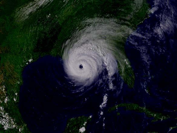
2 Katrina made landfall with the third-lowest central pressure (920 hpa) of any U.S. hurricane, but was only labeled a category 3. Why were the winds not stronger? Hurricane Katrina making landfall along the Louisiana and Mississippi coasts, as captured in visible imagery from the NOAA-15 satellite at 6:48 am CDT, 29 August 2005 (Image courtesy of NOAA).

3 The color microwave imagery displays Katrina with an intense single eyewall. The storm was rapidly strengthening over the Gulf Loop Current at this time. (Image courtesy of CIMSS.)

4 The color microwave imagery indicates that Katrina has begun an eyewall replacement cycle as spiral bands begin to coalesce into an outer eyewall. (Image courtesy of CIMSS.)

5 Microwave imagery continues to indicate the development of an outer eyewall in Katrina which almost completely encircles the inner eyewall. This ongoing eyewall replacement was one factor aiding the reduction of Katrina s maximum winds from earlier. However, the development of this outer eyewall greatly increased the size of the storm. (Image courtesy of CIMSS.)
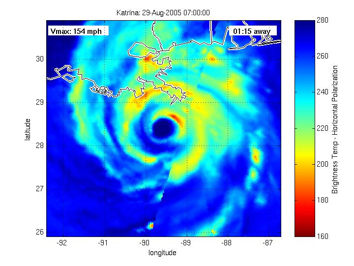
6 Color morphed microwave imagery of Hurricane Katrina at 7:00 am CDT, 29 August 2005 from the MIMIC (Morphed Integrated Microwave Imagery at CIMSS) system showing the double eyewall structure of Katrina as it makes landfall along the northern Gulf Coast.

7 Color morphed microwave imagery of Hurricane Katrina at 10:00 am CDT, 29 August 2005 from MIMIC showing continued evidence of an open double eyewall structure of Katrina as the inner eyewall crosses the Mississippi coast. Image courtesy of CIMSS.

8 MIMIC Microwave Loop Concentric Eyewall Structure
![NOAA Aircraft Reflectivity Cross Section [Single Eyewall] (Courtesy Hurricane](/docs-images/82/85082058/images/9-1.jpg "Research Division) NOAA Aircraft: N49RF, 1725-1818 UTC, 28 Aug 2005 (Northeast")
9 NOAA Aircraft Reflectivity Cross Section [Single Eyewall] (Courtesy Hurricane Research Division) NOAA Aircraft: N49RF, UTC, 28 Aug 2005 (Northeast Quad)

10 NOAA Aircraft: N49RF, UTC, 28 Aug 2005 (Northeast Quad) NOAA Aircraft Velocity Cross Section [Single Eyewall] (Courtesy Hurricane Research Division)

11 NOAA Aircraft Radar Reflectivity (Courtesy Hurricane Research Division) Concentric Eyewall Structure NOAA Aircraft: N43RF, 1023 UTC, 29 Aug 2005
12 NOAA Aircraft: N43RF, UTC, 29 Aug 2005 (East Quad) NOAA Aircraft Reflectivity Cross Section [Double Eyewall] (Courtesy Hurricane Research Division)
![NOAA Aircraft Velocity Cross Section [Double Eyewall] (Courtesy Hurricane](/docs-images/82/85082058/images/13-2.jpg "Research Division) NOAA Aircraft: N43RF, 1000-1040 UTC, 29 Aug 2005 (East")
13 NOAA Aircraft Velocity Cross Section [Double Eyewall] (Courtesy Hurricane Research Division) NOAA Aircraft: N43RF, UTC, 29 Aug 2005 (East Quad)

14 Katrina Dropsondes NOAA Dropsondes North of 28 N between 90.5 and 87.5 W. Source: NOAA/Hurricane Research Division
15 MIMIC Microwave Loop Max Dropsonde Winds (mph) below 2000 ft
 (From Franklin et al.")
16 Dropsonde Mean Wind Profiles Eyewall wind maxima are found near 500 m (1600 ft) elevation. Non-eyewall wind maxima are found much higher (closer to 1000 m [3000 ft]) (From Franklin et al., 2003 and TPC/NHC webpage) From TPC/NHC and AOML/ HRD
 Overlaid on Microwave Satellite")
 below")
17 Dropsonde Max Wind (mph) (sfc-2000 feet) Overlaid on Microwave Satellite Imagery MIMIC Microwave Image Max Pascagoula Dropsonde Wind (mph) below 2000 ft
18 Pascagoula Dropsonde Profile in Outer Eyewall (Courtesy Hurricane Research Division)
19 Surface Wind Estimates in the Outer Eyewall over Water Per Franklin et al. 2003, NHC Operational Procedures, and Franklin personal communication (March 2007), a surface (10 m) sustained wind can be estimated from the Pascagoula dropsonde (g ) by averaging the winds over a 150 m layer centered on the following levels: Method 1) 90% of 700 hpa wind 90% of 126 mph at 700 hpa (9435 feet) = 113 mph (113.4 mph) at 10 m. Method 2) 80% of 850 hpa wind 80% of 130 mph at 850 hpa (4000 feet) = 104 mph at 10 m. Method 3) Midpoint percent of the lowest 150 m of wind reports in dropsonde 76.5% of 134 mph at 285 m (961 feet) = 103 mph at 10 m. These estimates represent sustained 1 minute wind estimates. Are winds of approximately this strength found in any other dataset in the outer eyewall?

20 Yes! NOAA aircraft Stepped Frequency Microwave Radiometer (SFMR) data shows an outer surface wind maximum up to 105 mph south of Pascagoula, directly within the outer eyewall and at nearly the same time as the Pascagoula dropsonde. Outer Eyewall Wind Maximum Pascagoula HRD s H*Wind profile shows no such outer wind maximum. Courtesy of Eric Uhlhorn (NOAA/AOML/HRD), Pat Fitzpatrick (Stennis/Miss State Univ.), and Ben Jelley (WorldWinds Inc.) H*Wind
 making landfall.")

21 Reconstructions of Katrina s wind field generally show only a single eyewall storm (i.e., a storm with only one RMW) making landfall. For instance, HRD s H*Wind analysis program fails to show a double eyewall structure in Katrina at landfall.
 and storm size near landfall in Mississippi (similar to H*Wind).")
22 Neither does the Corps of Engineer s IPET simulation Also, notice the likely erroneous decrease in radius of maximum wind (RMW) and storm size near landfall in Mississippi (similar to H*Wind). From IPET
23 We believe the IPET simulation (and possibly H*Wind) was confusing inner and outer eyewalls, resulting in rapid fluctuations in RMW near landfall. These RMW fluctuations appear unrealistic. From IPET

24 Conclusions The massive size of Katrina s wind field was a product of concentric (double) eyewall structure at and before landfall on the northern Gulf Coast. The strengthening of the outer eyewall reduced the maximum winds in the inner eyewall, thus allowing a hpa storm to display only category 3 sustained winds at landfall. This double eyewall structure is not portrayed in most (if not all) storm re-constructions of Katrina s wind field at landfall. Virtually the entire Mississippi Coast suffered the impact of at least one eyewall in Katrina. Some locations received two eyewall impacts. The microwave satellite imagery shows potential for identifying regions in the hurricane containing strong sustained winds and gusts. (based on comparisons with dropsondes, radar, SFMR, and some surface observations [not shown]). Microwave and MIMIC imagery can provide an important operational nowcast tool for identifying eyewalls and regions of strong surface winds within hurricanes.


25
26
27 Slides Not Used, but kept for potential questions.
28 South of Pearlington MS Dropsonde in Outer Eyewall (Courtesy Hurricane Research Division)
29 Surface Wind Estimates in the Outer Eyewall over Water Per Franklin et al. 2003, NHC Operational Procedures, and Franklin personal communication (March 2007), a surface (10 m) sustained wind can be estimated near Pearlington/Waveland from the dropsonde (g ) by averaging the winds over a 150 m layer centered on the following levels: Method 1) 90% of 700 hpa wind 90% of 128 mph at 700 hpa (9017 feet) = 115 mph at 10 m. Method 2) 80% of 850 hpa wind 80% of 135 mph at 850 hpa (3567 feet) = 108 mph at 10 m. Method 3) Midpoint percent of the lowest 150 m of wind reports in dropsonde 83.8% of 121 mph at 95 m (301 feet) = 101 mph at 10 m. These estimates represent sustained 1 minute wind estimates. Thus, mid-to high category 2 sustained winds were likely in the outer eyewall in the vicinity of Pearlington/Waveland shortly after 7 am CDT. Slidell NWS Doppler also supports winds near the speeds shown in outer eyewall dropsondes. What were the gusts in this outer eyewall?
P2.37 EXTREME WINDS ASSOCIATED WITH A COLLAPSING CORE ON THE MOBILE WATERFRONT DURING THE LANDFALL OF HURRICANE KATRINA 2.
 P2.37 EXTREME WINDS ASSOCIATED WITH A COLLAPSING CORE ON THE MOBILE WATERFRONT DURING THE LANDFALL OF HURRICANE KATRINA Keith G. Blackwell, Aaron Williams, and Jason Holmes Coastal Weather Research Center
Hurricane Structure: Theory and Application. John Cangialosi National Hurricane Center
 Hurricane Structure: Theory and Application John Cangialosi National Hurricane Center World Meteorological Organization Workshop Is this Tropical, Subtropical, or Extratropical? Subtropical Tropical Extratropical
Homework 2: Hurricane Katrina. Part 1. Hurricane Katrina, August 28, 2005 Satellite Imagery
 Metr 302 Homework 2 Fall 2014 Meteorology 302 Fall 2014 Name Homework 2: Hurricane Katrina 100 points total Distributed Thursday 30 October 2014; Due Thursday 13 November 2014 Answer all questions in complete
Hurricane Structure: Theory and Diagnosis
 Hurricane Structure: Theory and Diagnosis 7 March, 2016 World Meteorological Organization Workshop Chris Landsea Chris.Landsea@noaa.gov National Hurricane Center, Miami Outline Structure of Hurricanes
HURRICANE IVAN CHARACTERISTICS and STORM TIDE EVALUATION
 HURRICANE IVAN CHARACTERISTICS and STORM TIDE EVALUATION By Robert Wang and Michael Manausa Sponsored by Florida Department of Environmental Protection, Bureau of Beaches and Coastal Systems Submitted
Specification of Tropical Cyclone Parameters From Aircraft Reconnaissance. Andrew Cox and Vincent Cardone Oceanweather Inc.
 Specification of Tropical Cyclone Parameters From Aircraft Reconnaissance Andrew Cox and Vincent Cardone Oceanweather Inc. Cos Cob, CT, USA Motivation This paper is part of on-going work to improve the
HURRICANE FRANCES CHARACTERISTICS and STORM TIDE EVALUATION
 HURRICANE FRANCES CHARACTERISTICS and STORM TIDE EVALUATION ((DRAFT)) By Robert Wang and Michael Manausa Sponsored by Florida Department of Environmental Protection, Bureau of Beaches and Coastal Systems
ERTH 365 Homework #2: Hurricane Harvey. 100 points
 ERTH 365 Homework #2: Hurricane Harvey 100 points Due by 6pm, Tuesday 30 October 2018, ELECTRONIC SUBMISSON BY EMAIL ONLY BY 6PM (send to klevey@sfsu.edu) (acceptable formats: MS Word, Google Doc, plain
HURRICANE CHARLEY CHARACTERISTICS and STORM TIDE EVALUATION
 HURRICANE CHARLEY CHARACTERISTICS and STORM TIDE EVALUATION By Robert Wang, Michael Manausa And Jenny Cheng Sponsored by Florida Department of Environmental Protection, Bureau of Beaches and Coastal Systems
HURRICANE JEANNE CHARACTERISTICS and STORM TIDE EVALUATION
 HURRICANE JEANNE CHARACTERISTICS and STORM TIDE EVALUATION ((DRAFT)) By Robert Wang and Michael Manausa Sponsored by Florida Department of Environmental Protection, Bureau of Beaches and Coastal Systems
Impact of Assimilating Airborne Doppler Radar Velocity Data Using the ARPS 3DVAR on the Analysis and Prediction of Hurricane Ike (2008)
") 1 2 3 4 5 6 7 8 9 10 11 12 13 14 15 16 17 18 19 20 21 22 23 24 25 26 27 28 29 30 31 32 33 34 35 36 37 38 Impact of Assimilating Airborne Doppler Radar Velocity Data Using the ARPS 3DVAR on the Analysis
1 2 3 4 5 6 7 8 9 10 11 12 13 14 15 16 17 18 19 20 21 22 23 24 25 26 27 28 29 30 31 32 33 34 35 36 37 38 Impact of Assimilating Airborne Doppler Radar Velocity Data Using the ARPS 3DVAR on the Analysis
16D.3 EYEWALL LIGHTNING OUTBREAKS AND TROPICAL CYCLONE INTENSITY CHANGE
 16D.3 EYEWALL LIGHTNING OUTBREAKS AND TROPICAL CYCLONE INTENSITY CHANGE Nicholas W. S. Demetriades and Ronald L. Holle Vaisala Inc., Tucson, Arizona, USA Steven Businger University of Hawaii Richard D.
SMAP Winds. Hurricane Irma Sep 5, AMS 33rd Conference on Hurricanes and Tropical Meteorology Ponte Vedra, Florida, 4/16 4/20, 2018
 Intensity and Size of Strong Tropical Cyclones in 2017 from NASA's SMAP L-Band Radiometer Thomas Meissner, Lucrezia Ricciardulli, Frank Wentz, Remote Sensing Systems, Santa Rosa, USA Charles Sampson, Naval
The Atlantic Hurricane Database Reanalysis Project
 The Atlantic Hurricane Database Reanalysis Project 9 November, 2015 14 th International Workshop on Wave Hindcasting and Forecasting Chris Landsea, National Hurricane Center, Miami, USA Chris.Landsea@noaa.gov
LECTURE #18: Hurricane Damage, Monitoring & Case Study
 GEOL 0820 Ramsey Natural Disasters Spring, 2018 LECTURE #18: Hurricane Damage, Monitoring & Case Study Date: 27 March 2018 I. Exam II grades now posted online o high: 98, low: 46, average: 80 (~3 points
Hurricane Wilma Post Storm Data Acquisition Estimated Peak Wind Analysis and Storm Tide Data. December 27, 2005
 Hurricane Wilma Post Storm Data Acquisition Estimated Peak Wind Analysis and Storm Tide Data December 27, 2005 Hurricane Wilma was the sixth major hurricane of the record-breaking 2005 Atlantic hurricane
30 If Vmax > 150, HSI intensity pts = 25
 Hurricane Severity Index: A New Way of Estimating a Tropical Cyclone s Destructive Potential 1. Introduction Christopher G. Hebert*, Robert A. Weinzapfel*, Mark A. Chambers* Impactweather, Inc., Houston,
WEDNESDAY 30 TH AUGUST, :57 p.m. Tropical Storm Irma forms in the Atlantic. Don t let your guard down, always #Be Ready.
 Chapter 1 - The Set Up In the days leading up to Irma a series of composed and sobering text messages, presented in truncated form below, from Department of Disaster Management warned us of the pending
Lecture #18 (April 12, 2010, Monday) Tropical Storms & Hurricanes Part 3. Hurricane Floyd September 15, 1999
 Tropical Storms & Hurricanes Part 3. Hurricane Floyd September 15, 1999") Lecture #18 (April 12, 2010, Monday) Tropical Storms & Hurricanes Part 3 Hurricane Floyd September 15, 1999 Tropical Cyclone Names Names are given to distinguish storms and for ease of communication. Names
Lecture #18 (April 12, 2010, Monday) Tropical Storms & Hurricanes Part 3 Hurricane Floyd September 15, 1999 Tropical Cyclone Names Names are given to distinguish storms and for ease of communication. Names
Frank Revitte National Weather Service. Weather Forecast Office New Orleans/Baton Rouge
 Frank Revitte National Weather Service Weather Forecast Office New Orleans/Baton Rouge Above normal activity 17 Total Named Storms 7 Tropical Storms 4 Hurricanes 6 Major Hurricanes Not the most active,
KCC White Paper: The 100 Year Hurricane. Could it happen this year? Are insurers prepared? KAREN CLARK & COMPANY. June 2014
 KAREN CLARK & COMPANY KCC White Paper: The 100 Year Hurricane Could it happen this year? Are insurers prepared? June 2014 Copyright 2014 Karen Clark & Company The 100 Year Hurricane Page 1 2 COPLEY PLACE
Ch. 11: Hurricanes. Be able to. Define what hurricane is. Identify the life and death of a hurricane. Identify the ways we track hurricanes.
 Ch. 11: Hurricanes Be able to Define what hurricane is. Identify the life and death of a hurricane. Identify the ways we track hurricanes. What are Hurricanes? Smaller than mid-latitude cyclones. Don t
P4.10. Kenichi Kusunoki 1 * and Wataru Mashiko 1 1. Meteorological Research Institute, Japan
 P4. DOPPLER RADAR INVESTIGATIONS OF THE INNER CORE OF TYPHOON SONGDA (24) Polygonal / elliptical eyewalls, eye contraction, and small-scale spiral bands. Kenichi Kusunoki * and Wataru Mashiko Meteorological
Modeling Nearshore Waves for Hurricane Katrina
 Modeling Nearshore Waves for Hurricane Katrina Jane McKee Smith US Army Engineer Research & Development Center Coastal and Hydraulics Laboratory Outline Introduction Modeling Approach Hurricane Katrina
P1.6 Simulation of the impact of new aircraft and satellite-based ocean surface wind measurements on H*Wind analyses
 P1.6 Simulation of the impact of new aircraft and satellite-based ocean surface wind measurements on H*Wind analyses Timothy L. Miller 1, R. Atlas 2, P. G. Black 3, J. L. Case 4, S. S. Chen 5, R. E. Hood
What s s New for 2009
 What s s New for 2009 Graphical Tropical Weather Outlook becomes operational Special Tropical Disturbance Statement replaced with Special Tropical Weather Outlook Tropical Cyclone Wind Field Graphic becomes
(April 7, 2010, Wednesday) Tropical Storms & Hurricanes Part 2
 Tropical Storms & Hurricanes Part 2") Lecture #17 (April 7, 2010, Wednesday) Tropical Storms & Hurricanes Part 2 Hurricane Katrina August 2005 All tropical cyclone tracks (1945-2006). Hurricane Formation While moving westward, tropical disturbances
Lecture #17 (April 7, 2010, Wednesday) Tropical Storms & Hurricanes Part 2 Hurricane Katrina August 2005 All tropical cyclone tracks (1945-2006). Hurricane Formation While moving westward, tropical disturbances
Unmanned Aircraft Hurricane Reconnaissance. Pat Fitzpatrick GeoSystems Research Institute Mississippi State University Stennis Space Center branch
 Unmanned Aircraft Hurricane Reconnaissance Pat Fitzpatrick GeoSystems Research Institute Mississippi State University Stennis Space Center branch Outline Motivation Unmanned Aircraft Systems (UAS) [also
Hurricane Initialization Using Airborne Doppler Radar Data for WRF
 Hurricane Initialization Using Airborne Doppler Radar Data for WRF Qingnong Xiao* 1, Xiaoyan Zhang 1, Christopher Davis 1, John Tuttle 1, Greg Holland 1, Pat Fitzpatrick 2 1. Mesoscale and Microscale Meteorology
Advanced diagnostics of tropical cyclone inner-core structure using aircraft observations
 Advanced diagnostics of tropical cyclone inner-core structure using aircraft observations Jun Zhang, David Nolan, Robert Rogers, Paul Reasor and Sylvie Lorsolo HFIP Proposal Review, 5/15/2013 Acknowledgements
Hurricane Harvey: SE Texas Impacts. 10 PM CDT UPDATE Friday, August 25, 2017 Prepared by: Lance Wood
 Hurricane Harvey: SE Texas Impacts 10 PM CDT UPDATE Friday, August 25, 2017 Prepared by: Lance Wood Latest Observations Hurricane Harvey making landfall this evening near Rockport as a category 4 hurricane.
Experiments of Hurricane Initialization with Airborne Doppler Radar Data for the Advancedresearch Hurricane WRF (AHW) Model
 Model") Experiments of Hurricane Initialization with Airborne Doppler Radar Data for the Advancedresearch Hurricane WRF (AHW) Model Qingnong Xiao 1, Xiaoyan Zhang 1, Christopher Davis 1, John Tuttle 1, Greg Holland
Experiments of Hurricane Initialization with Airborne Doppler Radar Data for the Advancedresearch Hurricane WRF (AHW) Model Qingnong Xiao 1, Xiaoyan Zhang 1, Christopher Davis 1, John Tuttle 1, Greg Holland
Navigating the Hurricane Highway Understanding Hurricanes With Google Earth
 Navigating the Hurricane Highway Understanding Hurricanes With Google Earth 2008 Amato Evan, Kelda Hutson, Steve Kluge, Lindsey Kropuenke, Margaret Mooney, and Joe Turk Images and data courtesy hurricanetracking.com,
A Tropical Cyclone with a Very Large Eye
 JANUARY 1999 PICTURES OF THE MONTH 137 A Tropical Cyclone with a Very Large Eye MARK A. LANDER University of Guam, Mangilao, Guam 9 September 1997 and 2 March 1998 1. Introduction The well-defined eye
Hurricane Isaac. National Weather Service. Communication Challenges and The Future. Weather Forecast Office New Orleans/Baton Rouge
 Hurricane Isaac Communication Challenges and The Future National Weather Service Weather Forecast Office New Orleans/Baton Rouge Hurricane Isaac Challenges 2012 Tropical Season Season was quiet for Louisiana
Improved Tropical Cyclone Boundary Layer Wind Retrievals. From Airborne Doppler Radar
 Improved Tropical Cyclone Boundary Layer Wind Retrievals From Airborne Doppler Radar Shannon L. McElhinney and Michael M. Bell University of Hawaii at Manoa Recent studies have highlighted the importance
GC Briefing. Weather Sentinel Tropical Storm Michael. Status at 8 AM EDT (12 UTC) Today (NHC) Discussion. October 11, 2018
 Today (NHC) Discussion. October 11, 2018") GC Briefing Weather Sentinel Tropical Storm Michael October 11, 2018 After making landfall as a high-end category-4 hurricane on the Florida Panhandle, Michael weakened to tropical storm status early this
GC Briefing Weather Sentinel Tropical Storm Michael October 11, 2018 After making landfall as a high-end category-4 hurricane on the Florida Panhandle, Michael weakened to tropical storm status early this
The spatial contribution of translation speed to tropical cyclone wind structure
 The spatial contribution of translation speed to tropical cyclone wind structure Pat Fitzpatrick and Yee Lau Geosystems Research Institute at Stennis Mississippi State University Basic issue: the methodologies
University of Miami/RSMAS
 Observing System Simulation Experiments to Evaluate the Potential Impact of Proposed Observing Systems on Hurricane Prediction: R. Atlas, T. Vukicevic, L.Bucci, B. Annane, A. Aksoy, NOAA Atlantic Oceanographic
Bradley W. Klotz 1, 2 and Eric W. Uhlhorn 2. NOAA/AOML/HRD, Miami, Florida 1. INTRODUCTION
 13B.6 STEPPED FREQUENCY MICROWAVE RADIOMETER ALGORITHM IMPROVEMENTS ADDRESSING RAIN CONTAMINATION OF SURFACE WIND SPEED MEASUREMENTS IN TROPICAL CYCLONES Bradley W. Klotz 1, 2 and Eric W. Uhlhorn 2 1 University
Chapter 16, Part Hurricane Paths. 2. Hurricane Paths. Hurricane Paths and Damage
 Chapter 16, Part 2 Hurricane Paths and Damage 1. Hurricane Paths Start over tropical water except South Atlantic and eastern South Atlantic, where water is too cold. Initially steered by easterly winds
Tropical Storms & Hurricanes Part 1. August 1992
 Lecture #16 (April 5, 2010, Monday) Tropical Storms & Hurricanes Part 1 August 1992 Tracks of rain accumulation & clouds from Hurricane Rita September 2005 Tropical Cyclones Around the Globe Why none here?
Feel free to ask for help also, we will try our best to answer your question or at least direct you to where you can find the answer.
 Page 1 Objectives: Become familiar with online resources and image searching tools Interpret different types of satellite imagery Learn about the variety of different types of TCs Part 1: Browse available
TROPICAL STORM HARVEY BRIEFING
 TROPICAL STORM HARVEY BRIEFING 2:00 PM CDT Tuesday, August 29, 2017 Prepared by: NWS LIX NWSNewOrleans www.weather.gov/neworleans Situation Overview New Information Moving NNE Max sustained wind 45 mph
Retrieving Surface Wind Directions from Neural-Net Wind Speed Retrievals in Tropical Cyclones
 Retrieving Surface Wind Directions from Neural-Net Wind Speed Retrievals in Tropical Cyclones Ralph Foster, Applied Physics Laboratory, University of WA Jerome Patoux, Atmospheric Sciences, University
(Preliminary) Observations of Tropical Storm Fay Dustin W Phillips Kevin Knupp, & Tim Coleman. 34th Conference on Radar Meteorology October 8, 2009
 Observations of Tropical Storm Fay Dustin W Phillips Kevin Knupp, & Tim Coleman. 34th Conference on Radar Meteorology October 8, 2009") (Preliminary) Observations of Tropical Storm Fay Dustin W Phillips Kevin Knupp, & Tim Coleman 34th Conference on Radar Meteorology October 8, 2009 Outline I. Research Equipment MIPS, MAX, KJAX (WSR-88D)
(Preliminary) Observations of Tropical Storm Fay Dustin W Phillips Kevin Knupp, & Tim Coleman 34th Conference on Radar Meteorology October 8, 2009 Outline I. Research Equipment MIPS, MAX, KJAX (WSR-88D)
8.1 RECENT RESULTS FROM NOAA'S HURRICANE INTENSITY FORECAST EXPERIMENT (IFEX)
") 8.1 RECENT RESULTS FROM NOAA'S HURRICANE INTENSITY FORECAST EXPERIMENT (IFEX) Frank Marks 1 NOAA/AOML, Hurricane Research Division, Miami, FL 1. INTRODUCTION In 2005 and 2006, NOAA's Hurricane Research
8.1 RECENT RESULTS FROM NOAA'S HURRICANE INTENSITY FORECAST EXPERIMENT (IFEX) Frank Marks 1 NOAA/AOML, Hurricane Research Division, Miami, FL 1. INTRODUCTION In 2005 and 2006, NOAA's Hurricane Research
Tri-Agency Forecast Discussion for August 24, 2010
 Created 1600 UTC August 24, 2010 Tri-Agency Forecast Discussion for August 24, 2010 GRIP Forecast Team: Cerese Inglish, Matt Janiga, Andrew Martin, Dan Halperin, Jon Zawislak, Ellen Ramirez, Amber Reynolds,
A NEW SAR RETRIEVAL METHOD FOR HURRICANE WIND PARAMETERS
 A NEW SAR RETRIEVAL METHOD FOR HURRICANE WIND PARAMETERS Antonio Reppucci, Susanne lehner, Johannes Schulz-Stellenfleth German Aerospace Center (DLR) Oberpfaffenhofen 82234 Wessling, Germany. Hurricane
An analysis of storm surge attenuation by wetlands using USGS, FEMA, and NASA data
 An analysis of storm surge attenuation by wetlands using USGS, FEMA, and NASA data Pat Fitzpatrick Geosystems Research Institute Mississippi State University Walter Peterson and Courtney Buckley NASA Marshall
An Ensemble based Reliable Storm Surge Forecasting for Gulf of Mexico
 An Ensemble based Reliable Storm Surge Forecasting for Gulf of Mexico Umer Altaf Delft University of Technology, Delft ICES, University of Texas at Austin, USA KAUST, Saudi Arabia JONSMOD 2012, Ifremer,
Storm Summary for Hurricane Joaquin
 Storm Summary for Hurricane Joaquin Wednesday, September 30, 2015 at 5 PM EDT (Output from Hurrevac, based on National Hurricane Center Forecast Advisory #12) Joaquin is currently a Category 1 hurricane
Atmospheric Motions Derived From Space Based Measurements: A Look To The Near Future. James F.W. Purdom
 Atmospheric Motions Derived From Space Based Measurements: A Look To The Near Future James F.W. Purdom Director, Office of Research and Applications NOAA/NESDIS 1. Introduction This short note addresses
RapidScat Along Coasts and in Hurricanes. Bryan Stiles, Alex Fore, Sermsak Jaruwatanadilok, and Ernesto Rodriguez May 20, 2015
 RapidScat Along Coasts and in Hurricanes Bryan Stiles, Alex Fore, Sermsak Jaruwatanadilok, and Ernesto Rodriguez May 20, 2015 Outline Description of Improved Rain Correction for RapidScat Hybrid of current
Kimberly J. Mueller Risk Management Solutions, Newark, CA. Dr. Auguste Boissonade Risk Management Solutions, Newark, CA
 1.3 The Utility of Surface Roughness Datasets in the Modeling of United States Hurricane Property Losses Kimberly J. Mueller Risk Management Solutions, Newark, CA Dr. Auguste Boissonade Risk Management
Tropical Cyclone Modeling and Data Assimilation. Jason Sippel NOAA AOML/HRD 2018 WMO Workshop at NHC
 Tropical Cyclone Modeling and Data Assimilation Jason Sippel NOAA AOML/HRD 2018 WMO Workshop at NHC Outline History of TC forecast improvements in relation to model development Ongoing modeling/da developments
Tuesday, September 13, 16
 Weather Weather State Objectives 4.c, 4.d, 4.h. Discussion What are some ways in which weather affects your everyday life? Discussion What are some ways in which weather affects your everyday life? What
Tropical Cyclone Data Impact Studies: Influence of Model Bias and Synthetic Observations
 Tropical Cyclone Data Impact Studies: Influence of Model Bias and Synthetic Observations C. Reynolds, R. Langland and P. Pauley, Naval Research Laboratory, Marine Meteorology Division, Monterey, CA C.
HURRICANE NATE BRIEFING
 HURRICANE NATE BRIEFING 2:00 PM CDT Saturday, October 07, 2017 Prepared by: NWS NWSNewOrleans www.weather.gov/neworleans Situation Overview continues to intensify. It is now forecast to be a category 2
WindSat Ocean Surface Emissivity Dependence on Wind Speed in Tropical Cyclones. Amanda Mims University of Michigan, Ann Arbor, MI
 WindSat Ocean Surface Emissivity Dependence on Wind Speed in Tropical Cyclones Amanda Mims University of Michigan, Ann Arbor, MI Abstract Radiometers are adept at retrieving near surface ocean wind vectors.
2008 Hurricane Caravan. Daniel Noah Meteorologist National Weather Service x1 May 22, 2008
 2008 Hurricane Caravan Daniel Noah Meteorologist National Weather Service daniel.noah@noaa.gov, 813-645-2323 x1 May 22, 2008 National Weather Service We never close! Open 24 hours a day 365 days per year
Vertical structure of the atmosphere
 Vertical structure of the atmosphere Stratosphere ozone layer / ozone hole ultraviolet solar radiation sulfate aerosols from volcanic eruptions increasing GHG produces cooling Troposphere most clouds
Current Details from the National Hurricane Center (NHC)
") Current Watches and Warnings A Hurricane Warning is in effect from Port Mansfield to Sargent, Texas A Warning is in effect from north of Sargent to High Island, Texas; south of Port Mansfield, Texas to
Current Watches and Warnings A Hurricane Warning is in effect from Port Mansfield to Sargent, Texas A Warning is in effect from north of Sargent to High Island, Texas; south of Port Mansfield, Texas to
Hurricanes. Hurricanes are large, tropical storm systems that form and develop over the warm waters near the equator.
 Hurricanes Hurricanes are large, tropical storm systems that form and develop over the warm waters near the equator. They are responsible for weather that can devastate entire communities: Heavy rain --
SLOSH New Orleans Basin 2012 Update
 SLOSH New Orleans Basin 2012 Update Michael Koziara Science and Operations Officer National Weather Service Slidell, LA The Basics What is storm surge? What is SLOSH? Details Assumptions Inundation = Storm
Severe Weather: Tornadoes and Hurricanes
 Severe Weather: Tornadoes and Hurricanes Tornadoes Grab Toto!! TORNADOES Are a low pressure storm that usually forms over land in an average year, 800 tornadoes are reported in the U.S. a tornado is defined
Comparison of reflected GPS wind speed retrievals with dropsondes in tropical cyclones
 GEOPHYSICAL RESEARCH LETTERS, VOL. 36, L17602, doi:10.1029/2009gl039512, 2009 Comparison of reflected GPS wind speed retrievals with dropsondes in tropical cyclones Stephen J. Katzberg 1 and Jason Dunion
Objectives for meeting
 Objectives for meeting 1) Summarize planned experiments 2) Discuss resource availability Aircraft Instrumentation Expendables 3) Assign working groups to complete each experiment plan Flight planning and
A Look Back at the 2012 Hurricane Season and a Look Ahead to 2013 & Beyond. Daniel Brown National Hurricane Center Miami, Florida 24 April 2013
 A Look Back at the 2012 Hurricane Season and a Look Ahead to 2013 & Beyond Daniel Brown National Hurricane Center Miami, Florida 24 April 2013 2012 Atlantic Verification Good News- Lots of Accuracy Records
THE ROLE PLAYED BY BLOCKING OVER THE NORTHERN HEMISPHERE ON HURRICANE KATRINA
 THE ROLE PLAYED BY BLOCKING OVER THE NORTHERN J P 3.51 HEMISPHERE ON HURRICANE KATRINA Yehia Hafez* University of Cairo, Giza, Egypt ABSTARCT On year 2005, there exist 28 tropical Atlantic storms and hurricanes
Unit 7 Section 3 Computer Lab. Part 1: OPEN OCEAN AND COASTAL IMPACTS OF TROPICAL CYCLONES
 Unit 7 Section 3 Computer Lab Part 1: OPEN OCEAN AND COASTAL IMPACTS OF TROPICAL CYCLONES Educational Outcomes: Tropical cyclones are significant phenomena in the Earth system. They are as much oceanic
Tropical Update. 5 AM EDT Wednesday, September 6, 2017 Hurricane Irma, Tropical Storm Jose, and Tropical Storm Katia
 Tropical Update 5 AM EDT Wednesday, September 6, 2017 Hurricane Irma, Tropical Storm Jose, and Tropical Storm Katia This update is intended for government and emergency response officials, and is provided
10 years after Hurricane Charley
 10 years after Hurricane Charley Hurricane Charley (2004) A Retrospective Scott M. Spratt Warning Coordination Meteorologist NWS Melbourne, FL Florida Governors Hurricane Conference May 15, 2014 11 AM
Hurricane KATRINA Lessons Learned for Managing Risk
 Hurricane KATRINA Lessons Learned for Managing Risk Steven L. Stockton, P.E. Deputy Director of Civil Works U.S. Army Corps of Engineers What Happened? Storm Path from August 23 to 31, 2005 Mon. August
P2.8 LONG-RANGE LIGHTNING APPLICATIONS FOR HURRICANE INTENSITY. Nicholas W. S. Demetriades and Ronald L. Holle Vaisala, Inc.
 P2.8 LONG-RANGE LIGHTNING APPLICATIONS FOR HURRICANE INTENSITY Nicholas W. S. Demetriades and Ronald L. Holle Vaisala, Inc., Tucson, Arizona. INTRODUCTION Vaisala has been operating an experimental longrange
HURRICANE HARVEY COE Navigation BRIEFING
 HURRICANE HARVEY COE Navigation BRIEFING 10:00 AM CDT Friday, August 25, 2017 NWSNewOrleans www.weather.gov/neworleans Situation Overview New Information Harvey continues to strengthen Max sustained winds
Derrick Herndon and Chris Velden University of Wisconsin - Madison Cooperative Institute for Meteorological Satellite Studies
 Derrick Herndon and Chris Velden University of Wisconsin - Madison Cooperative Institute for Meteorological Satellite Studies Presented at International Workshop on Satellite Analysis of Tropical Cyclones
An Assessment of the Climatology of Florida Hurricane-Induced Tornadoes (HITs): Technology versus Meteorology
: Technology versus Meteorology") 5218 J O U R N A L O F C L I M A T E VOLUME 24 An Assessment of the Climatology of Florida Hurricane-Induced Tornadoes (HITs): Technology versus Meteorology ERNEST M. AGEE AND ALYSSA HENDRICKS Department
5218 J O U R N A L O F C L I M A T E VOLUME 24 An Assessment of the Climatology of Florida Hurricane-Induced Tornadoes (HITs): Technology versus Meteorology ERNEST M. AGEE AND ALYSSA HENDRICKS Department
Hurricane Katrina Tracking Lab
 Hurricane Katrina Tracking Lab Introduction: The 2005 hurricane season was the most active season on record resulting in 28 named storms. Hurricane Katrina was the eleventh named storm and would end up
A Hurricane Outlook for the 21st Century.
 A Hurricane Outlook for the 21st Century. Hugh Willoughby Florida International University Cat Winds Effects One 74-95 mph No real damage to building structures. Two Three Four Five 96-110 mph 111-130
Current Details from the National Hurricane Center (NHC)
") Current Watches and Warnings A Hurricane Warning is in effect from Port Mansfield to Sargent, Texas A Warning is in effect from north of Sargent to High Island, Texas A Surge Warning is in effect from
Current Watches and Warnings A Hurricane Warning is in effect from Port Mansfield to Sargent, Texas A Warning is in effect from north of Sargent to High Island, Texas A Surge Warning is in effect from
Q-Winds satellite hurricane wind retrievals and H*Wind comparisons
 Q-Winds satellite hurricane wind retrievals and H*Wind comparisons Pet Laupattarakasem and W. Linwood Jones Central Florida Remote Sensing Laboratory University of Central Florida Orlando, Florida 3816-
A proposal to establish a dedicated Hurricane Model Evaluation and Improvement Project. Joseph Cione Eric Uhlhorn NOAA/Hurricane Research Division
 A proposal to establish a dedicated Hurricane Model Evaluation and Improvement Project Joseph Cione Eric Uhlhorn NOAA/Hurricane Research Division Motivation. Overall objective: Improve HWRF forecast performance
ANALYSIS AND DETECTION OF TORNADOES ASSOCIATED WITH HURRICANE EMILY
 ANALYSIS AND DETECTION OF TORNADOES ASSOCIATED WITH HURRICANE EMILY Kurt M. Van Speybroeck*, M. Martin, Jr., A. Patrick and J. Haro National Weather Service Brownsville, TX 1. INTRODUCTION Hurricane Emily
Derrick Herndon and Chris Velden University of Wisconsin - Madison Cooperative Institute for Meteorological Satellite Studies
 CIMSS SATellite CONsensus (SATCON) Derrick Herndon and Chris Velden University of Wisconsin - Madison Cooperative Institute for Meteorological Satellite Studies Presented at International Workshop on Satellite
DA/Initialization/Ensemble Development Team Milestones and Priorities
 DA/Initialization/Ensemble Development Team Milestones and Priorities Presented by Xuguang Wang HFIP annual review meeting Jan. 11-12, 2017, Miami, FL Fully cycled, self-consistent, dual-resolution, GSI
The Properties of Convective Clouds Over the Western Pacific and Their Relationship to the Environment of Tropical Cyclones
 The Properties of Convective Clouds Over the Western Pacific and Their Relationship to the Environment of Tropical Cyclones Principal Investigator: Dr. Zhaoxia Pu Department of Meteorology, University
Visualizing hurricanes
 Visualizing hurricanes NAME: DATE: Scientific visualization is an integral part of the process of simulating natural phenomena. In the computational sciences, the main goal is to understand the workings
Forecast Challenges of the 2017 Hurricane Season and NHC Priorities for 2018
 Forecast Challenges of the 2017 Hurricane Season and NHC Priorities for 2018 Michael J. Brennan, Mark DeMaria, Eric S. Blake, Richard J. Pasch, Andrew Penny Annual HFIP Meeting 8 November 2017 Outline
Low-end derecho of 19 August 2017
 Low-end derecho of 19 August 2017 By Richard H. Grumm and Charles Ross National Weather Service State College, PA 1. Overview A cluster of thunderstorms developed in eastern Ohio around 1800 UTC on 19
P4.1 CONSENSUS ESTIMATES OF TROPICAL CYCLONE INTENSITY USING MULTISPECTRAL (IR AND MW) SATELLITE OBSERVATIONS
 SATELLITE OBSERVATIONS") P4.1 CONSENSUS ESTIMATES OF TROPICAL CYCLONE INTENSITY USING MULTISPECTRAL (IR AND MW) SATELLITE OBSERVATIONS Christopher Velden* Derrick C. Herndon and James Kossin University of Wisconsin Cooperative
P4.1 CONSENSUS ESTIMATES OF TROPICAL CYCLONE INTENSITY USING MULTISPECTRAL (IR AND MW) SATELLITE OBSERVATIONS Christopher Velden* Derrick C. Herndon and James Kossin University of Wisconsin Cooperative
STORM HISTORY FOR COLLIER COUNTY
 STORM HISTORY FOR COLLIER COUNTY In 1960, when hurricane 'Donna' struck, there were approximately 15,500 people living full time in Collier County. Today there are more than 330,000 residents, most of
TROPICAL STORM HARVEY COE Navigation Call - Update
 TROPICAL STORM HARVEY COE Navigation Call - Update 10:00 AM CDT Tuesday, August 29, 2017 Prepared by: NWS LIX NWSNewOrleans www.weather.gov/neworleans Situation Overview New Information Drifting ENE at
General background on storm surge. Pat Fitzpatrick and Yee Lau Mississippi State University
 General background on storm surge Pat Fitzpatrick and Yee Lau Mississippi State University Storm surge is an abnormal rise of water associated with a cyclone, not including tidal influences Low pressure
Typhoon Maemi and Hurricane Katrina: Impacts and Aftermath. Typhoon Maemi: September 13, Typhoon Maemi Track and Characteristics
 Typhoon Maemi and Hurricane Katrina: Impacts and Aftermath Pierre Julien Un Ji Department of Civil Engineering Colorado State University Fort Collins, Colorado USA September, 2005 Typhoon Maemi: September
Weather Middle School Teacher Instructions and Activity
 Weather Middle School Teacher Instructions and Activity Based on the guidelines of the Saffir-Simpson Scale for hurricane severity and the Fujita Scale for tornado damage, students will write a brief synopsis
Photo by Herb Stein. Center for Severe Weather Research. Hurricane Studies. Photo by Herb Stein
 Photo by Herb Stein Center for Severe Weather Research Hurricane Studies Photo by Herb Stein DOW Hurricane Studies (or, what the DOWs do after tornado season is over) Missions are very challenging compared
Hurricane Tracking Lab
 Hurricane Tracking Lab Background: Hurricanes are one of nature s most powerful disasters. To equal the power of a hurricane, one would have to set off about a thousand nuclear devices per second for as
How does NASA study hurricanes? 17 August 2015, by Max Gleber
 How does NASA study hurricanes? 17 August 2015, by Max Gleber Hurricanes are the most powerful weather event on Earth. NASA's expertise in space and scientific exploration contributes to essential services
Hurricane Harvey the Name says it all. by Richard H. Grumm and Charles Ross National Weather Service office State College, PA
 Hurricane Harvey the Name says it all by Richard H. Grumm and Charles Ross National Weather Service office State College, PA 16803. 1. Overview Hurricane Harvey crossed the Texas coast (Fig. 1) as a category