Greater New Orleans Hurricane and Storm Damage Risk Reduction System 101
|
|
|
- Myra Wood
- 5 years ago
- Views:
Transcription


1 Greater New Orleans Hurricane and Storm Damage Risk Reduction System 101 René Poché New Orleans District U.S. Army Corps of Engineers US Army Corps of Engineers BUILDING STRONG


2 1878 Gentilly Ridge Metairie Ridge

3 CANAL ST AT RIVER ST LOUIS CATHEDRAL ESPLANADE AT ST. CLAUDE DERBIGNY AT I-10 GENTILLY BLVD AT ALLEN DILLARD UNIV CAMPUS ST ANTHONY AT FILMORE AVE WAINRIGHT DR AT L. C. SIMON UNO SIDE OF WAINWRIGHT DR ELEVATIONS IN FEET NGVD New Orleans Topography City of New Orleans Ground Elevations FLOODWALL ALONG MISSISSIPPI RIVER 23 FT A MR&T PROJECT DESIGN FLOWLINE (18 FEET) LAKE PONTCHARTRAIN B A NEW ORLEANS From Canal St. at Mississippi River to the Lakefront at U.N.O. LONDON AVENUE CANAL FLOODWALL HURRICANE LEVEE / FLOODWALL (14.0 FEET) B


4 Hurricane Katrina Aug 29, 2005 Hurricane Rita Sep 24, 2005 One of America s largest natural disasters Cat 5 less than 12 hrs before landfall 127 MPH wind at Louisiana landfall Maximum surge of 28 to 30 feet along Mississippi coast 80 percent of the city of New Orleans flooded Cat 4 less than 12 hrs before landfall 175 MPH max sustained winds in Gulf of Mexico 120 MPH max sustained winds at landfall Cat 3 strength at landfall 4 BUILDING STRONG


5 USACE s Actions for Change Comprehensive systems approach Risk-informed decision making Communication of risk to the public Professional and technical expertise 5


6 Deliver the Greater New Orleans HSDRRS Mission Challenges Mandate to deliver $14.6B construction program within budget and on schedule Deliver a comprehensive system Enablers Administration / Congressional commitment Fully funded program National / Regional Corps capabilities Local partners and stakeholders capabilities NEPA Alternate Arrangements Full host of acquisition strategies Favorable bidding climate 6


7 A Stronger System Than Ever Before Total System Openings: 493 Navigable Openings: 11 Roadway Openings: 144 Railroad Openings: 45 Access Openings: 134 Drainage Openings: th St. Orleans London Seabrook IHNC Surge Barrier Bayou Verret Caernarvon Harvey Floodgate West Closure Complex Bayou Segnette Hero 7 Canal BUILDING STRONG

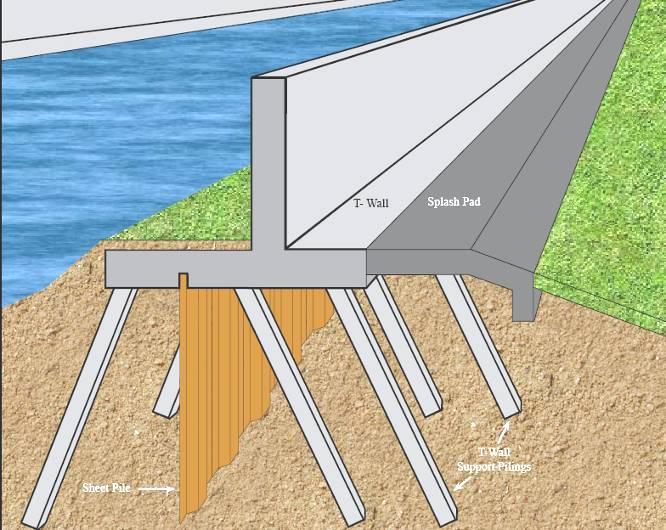
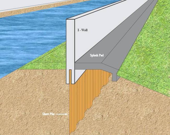
8 Design Improvements T/I wall design Scour protection Before After 8


9 New Orleans East New Floodwall Surge Barrier Tie-In Old Floodwall 9
 66 in dia spun")


10 IHNC Lake Borgne Surge Barrier 36 in dia steel pipe battered piles (240 ft long) 66 in dia spun cast concrete soldier piles (140 ft long) Precast and cast in place deck and parapet wall $1.1 Billion Design-Build Cost Reimbursable 1.8 mile span 150 ft sector gate and barge gate 54 ft vertical lift gate 10


11 Seabrook Gate Complex 95 ft sector gate Two 50 ft vertical lift flow control gates ~$170 Million Early Contractor Involvement (ECI) 11
")
12 West Closure Complex Largest drainage pump station in the world 19,140 cfs Largest sector gates in US 225 ft clear width Removed 26 miles of levees and floodwalls from the first line of defense ~$1 Billion Early Contractor Involvement (ECI) 12


13 West Closure Complex Pump Station 5400 hp diesel engines drive 11 flowerpot pumps 13


14 Interim Closure Structures Orleans Ave. Canal London Ave. Canal 17 th St. Canal All structures completed June 2006 Provide interim 100-yr level of risk reduction 14


15 Permanent Canals Closures and Pumps 17 th St. Canal London Ave. Canal Orleans Ave. Canal 15


16 HSDRRS Remaining Work SELA Interior Drainage Permanent Pump Stations Mississippi River / HSDRRS Co-located Levees Armoring Environmental New Orleans to Venice / Mitigation Non-Federal Levees


17 Armoring at Control Structure Transition Armoring Armoring at Floodgates Armoring at Railroad Floodgate Armoring Behind I-Wall / T-Wall 17 Slide 17


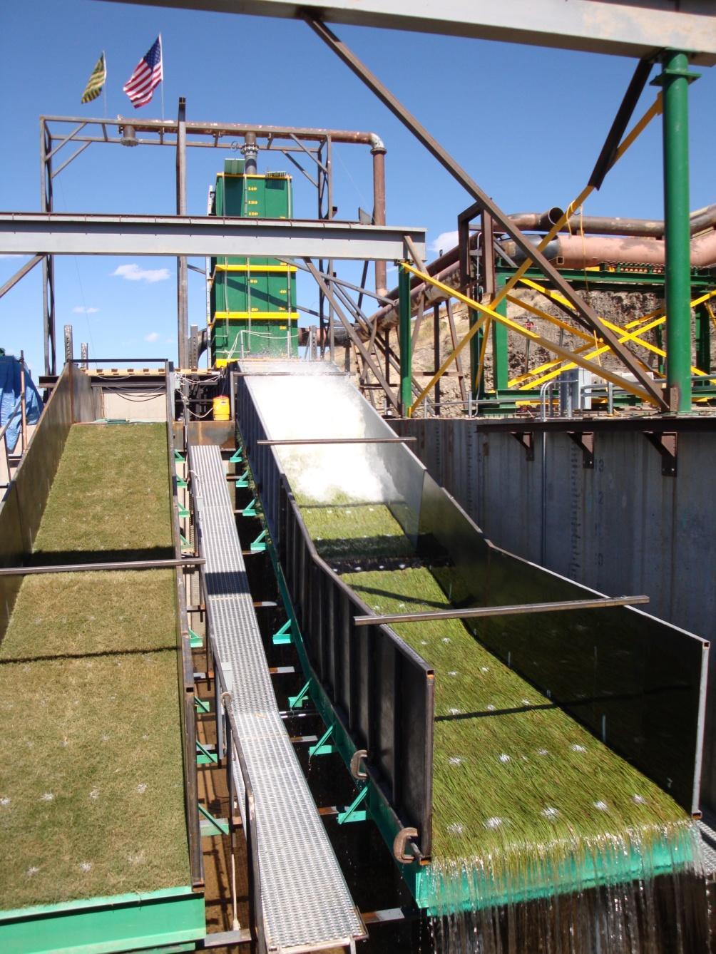
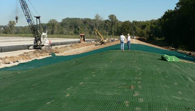
18 Armoring Turf Reinforcement Mat Wave Overtopping Testing 18 Sod / Enhanced Grass
19 In 2007, you had a 1% chance every year of flooding this deep from Hurricanes Notes: The depth map tool is a relative indicator of progress, over time, demonstrating risk reduction as a function of construction progress The water surface elevations are mean values The scale sensitivity of the legend is +/- 2 feet The info does not depict interior drainage modeling results The storm surge is characterized as the result of a probabilistic analysis of 5 to 6 storm parameters of a suite of 152 storms and not a particular event Assumes 50% Pumping Capacity 19 March 08

20 With the 100-year level of protection, you have a 1% chance every year of flooding this deep from Hurricanes Notes: The depth map tool is a relative indicator of progress, over time, demonstrating risk reduction as a function of construction progress The water surface elevations are mean values The scale sensitivity of the legend is +/- 2 feet The info does not depict interior drainage modeling results The storm surge is characterized as the result of a probabilistic analysis of 5 to 6 storm parameters of a suite of 152 storms and not a particular event Assumes 50% Pumping Capacity 20 March 08
21 Discussion / Questions 21
US Army Corps of Engineers BUILDING STRONG
 Greater New Orleans Hurricane and Storm Damage Risk Reduction System Robert Rowlette Senior Senior Program Manager Task Force Hope U.S. Army Corps of Engineers April 19, 2012 US Army Corps of Engineers
Hurricane KATRINA Lessons Learned for Managing Risk
 Hurricane KATRINA Lessons Learned for Managing Risk Steven L. Stockton, P.E. Deputy Director of Civil Works U.S. Army Corps of Engineers What Happened? Storm Path from August 23 to 31, 2005 Mon. August
Improvements to Southeast Louisiana s floodwalls and pump stations since Katrina: the Hurricane and Storm Damage Risk Reduction System (HSDRRS)
") Improvements to Southeast Louisiana s floodwalls and pump stations since Katrina: the Hurricane and Storm Damage Risk Reduction System (HSDRRS) Pat Fitzpatrick Mississippi State University Review of levee
Improvements to Southeast Louisiana s floodwalls and pump stations since Katrina: the Hurricane and Storm Damage Risk Reduction System (HSDRRS) Pat Fitzpatrick Mississippi State University Review of levee
Construction complete on all HSDRRS projects across storm evacuation routes
 Task Force Hope Status Report August 29, 2013 Construction complete on all HSDRRS projects across storm evacuation routes Eastern Tie-In Swing Gates positioned across Hwy. 23 By Susan Spaht If a tropical
PART 4 HURRICANE KATRINA STRIKES NEW ORLEANS AUGUST 2005
 PART 4 HURRICANE KATRINA STRIKES NEW ORLEANS AUGUST 2005 Hurricane Katrina Hurricane Katrina swept across southern Florida and lost momentum, then gained speed and water, showing the second lowest barometric
Hurricane Tracks. Isaac versus previous storms Impacts and solutions. ( Continue by clicking on the slide bar to the right)
") Hurricane Tracks Isaac versus previous storms Impacts and solutions ( Continue by clicking on the slide bar to the right) 1 Hurricane Tracks 2 Sample Hurricanes The sample hurricanes selected were chosen
Hurricane Tracks Isaac versus previous storms Impacts and solutions ( Continue by clicking on the slide bar to the right) 1 Hurricane Tracks 2 Sample Hurricanes The sample hurricanes selected were chosen
CHAPTER SEVEN: THE NEW ORLEANS EAST PROTECTED AREA
 7.1 Introduction CHAPTER SEVEN: THE NEW ORLEANS EAST PROTECTED AREA The New Orleans East (NEO) protected area includes some of the lowest ground in the metropolitan region. Therefore, it is not surprising
CHAPTER FIVE: THE LOWER MISSISSIPPI REGION AND PLAQUEMINES PARISH
 CHAPTER FIVE: THE LOWER MISSISSIPPI REGION AND PLAQUEMINES PARISH 5.1 Overview Plaquemines Parish is the area where the last portion of the Mississippi River flows out into the Gulf of Mexico (see Figures
PROBABILISTIC DESIGN METHOD OF LEVEE AND FLOODWALL HEIGHTS FOR THE HURRICANE PROTECTION SYSTEM IN THE NEW ORLEANS AREA
 PROBABILISTIC DESIGN METHOD OF LEVEE AND FLOODWALL HEIGHTS FOR THE HURRICANE PROTECTION SYSTEM IN THE NEW ORLEANS AREA Mathijs van Ledden Haskoning Inc., 1 Galleria Blvd., Metairie, LA70001, United States,
Geotechnical Challenges New Orleans USACE
 35 th Southwest Geotechnical Engineering Conference Geotechnical Challenges New Orleans USACE Mark Woodward, PE Jehu Johnson, EI Geotechnical Branch New Orleans District 28 April 2010 Slide 1 New Orleans
OSCILLATIONS OF SEMI-ENCLOSED WATER BODY INDUCED BY HURRICANES. Yuan-Hung Paul Tan 1 and Jiin-Jen Lee 1
 OSCILLATIONS OF SEMI-ENCLOSED WATER BODY INDUCED BY HURRICANES Yuan-Hung Paul Tan 1 and Jiin-Jen Lee 1 The primary focus of this research is to study the oscillations of semi-enclosed water body induced
HURRICANE ISAAC WITH AND WITHOUT YEAR HSDRRS EVALUATION
 HURRICANE ISAAC WITH AND WITHOUT 2012 100-YEAR HSDRRS EVALUATION FINAL REPORT FEBRUARY 2013 Executive Summary EXECUTIVE SUMMARY SIGNIFICANT FINDINGS According to the Saffir-Simpson Hurricane Wind Scale,
Smart Flood Risk Management Solutions
 Smart Flood Risk Management Solutions - RHDHV s Experience in the Gulf of Mexico Mathijs van Ledden, Marten Hillen and Ries Kluskens Challenge Extreme weather around the world (hurricanes, cyclones, extratropical
Hurricane Katrina August 29 th, 2005 Costliest Disaster/One of the 5 deadliest Hurricanes in US History. Total Cost: Approx. $100 Billion in damages O
 Eddie Katz Hurricane Katrina August 29 th, 2005 Costliest Disaster/One of the 5 deadliest Hurricanes in US History. Total Cost: Approx. $100 Billion in damages Over 15 million affected by Katrina whether
Report on the Damage Survey Caused by Hurricane Katrina (Tentative Report)
") Report on the Damage Survey Caused by Hurricane Katrina (Tentative Report) November 1, 2005 Coastal Disaster Prevention Technology Survey Team 1. Introduction Hurricane Katrina struck the United States
Report on the Damage Survey Caused by Hurricane Katrina (Tentative Report) November 1, 2005 Coastal Disaster Prevention Technology Survey Team 1. Introduction Hurricane Katrina struck the United States
SHORELINE PROTECTION & RESTORATION PROGRAM
 City of Mandeville, LA SHORELINE PROTECTION & RESTORATION PROGRAM June 8, 2017 Pre-Budget Background Presentation Prepared by: Overview Background Context: RSLR, Rigolets Closure City Program & Project
Background and Purpose of Meeting. River Towers Meeting. Flood Risk Management Study Alternatives Overview
 1 and Purpose of Meeting River Towers Meeting Flood Risk Management Study Alternatives Overview September 23, 2014 There is no "proposed" flood risk management solution for this area at this time Fairfax
Wetland attenuation of Hurricane Rita s storm surge
 Wetland attenuation of Hurricane Rita s storm surge Pat Fitzpatrick, Yee Lau, Yongzuo Li, Nam Tran, Chris Hill, and Suzanne Shean Geosystems Research Institute, Mississippi State University Sponsors: NOAA
Hurricane Surge Hazard Analysis for Southeast Louisiana
 Hurricane Surge Hazard Analysis for Southeast Louisiana SLFPA-E Coastal Advisory Committee and Invitees February 21, 2013 Presented by Bob Jacobsen PE, LLC Consulting Coastal Hydrologist Objective Review
KATRINA: What Went Wrong? And How to Fix it. ICHARM Commemorative Symposium. United Nations University/PWRI Tokyo, Japan 14 September, 2006
 KATRINA- What Went Wrong? KATRINA: What Went Wrong? And How to Fix it Lessons Learned & How to Fix it Lessons Learned ICHARM Commemorative Symposium United Nations University/PWRI Tokyo, Japan 14 September,
Appendix A STORM SURGE AND WAVE HEIGHT ANALYSIS
 Appendix A STORM SURGE AND WAVE HEIGHT ANALYSIS Memo To: Jeff Robinson, P.E., GEC, Inc. From: Silong Lu, Ph.D., P.E., D.WRE, Dynamic Solutions, LLC. Date: 1/9/2014 CC: Re: Chris Wallen, Vice President,
LECTURE #18: Hurricane Damage, Monitoring & Case Study
 GEOL 0820 Ramsey Natural Disasters Spring, 2018 LECTURE #18: Hurricane Damage, Monitoring & Case Study Date: 27 March 2018 I. Exam II grades now posted online o high: 98, low: 46, average: 80 (~3 points
Hurricanes and Storm Surge : Before coming to lab, visit the following web site:
 Geol 108 Lab #7 Week of October 15-19, 2012 Coastal Studies Hurricanes and Storm Surge : Before coming to lab, visit the following web site: http://www.usatoday.com/graphics/weather/gra/gsurge/flash.htm
MODELLING CATASTROPHIC COASTAL FLOOD RISKS AROUND THE WORLD
 MODELLING CATASTROPHIC COASTAL FLOOD RISKS AROUND THE WORLD Nicola Howe Christopher Thomas Copyright 2016 Risk Management Solutions, Inc. All Rights Reserved. June 27, 2016 1 OUTLINE MOTIVATION What we
THE NEW STORM SURGE MODULE IN AIR S U.S. HURRICANE MODEL
 THE NEW STORM SURGE MODULE IN AIR S U.S. HURRICANE MODEL Hurricane Ike storm surge devastation of Bolivar Peninsula near Galveston, Texas. (Source: Chuck Davis, flickr) When a hurricane comes onshore,
Phases of Disaster Response. John Yeaw, Gavin Vanstone, Haochen Wu, Jordan Tyler
 Phases of Disaster Response John Yeaw, Gavin Vanstone, Haochen Wu, Jordan Tyler BP Oil Spill One of the worst man made disasters in human history The BP oil spill occurred in April of 2010 when the Deepwater
Comparative Analysis of Hurricane Vulnerability in New Orleans and Baton Rouge. Dr. Marc Levitan LSU Hurricane Center. April 2003
 Comparative Analysis of Hurricane Vulnerability in New Orleans and Baton Rouge Dr. Marc Levitan LSU Hurricane Center April 2003 In order to compare hurricane vulnerability of facilities located in different
Lessons Learned from Analysis of the New Orleans Hurricane Protection System
 Lessons Learned from Analysis of the New Orleans Hurricane Protection System By Interagency Performance Evaluation Task Force Reported by Michael K. Sharp ABSTRACT This report, Performance Evaluation of
Benchmarking of Hydrodynamic Models for Development of a Coupled Storm Surge Hazard-Infrastructure Modeling Method to improve Inundation Forecasting
 Benchmarking of Hydrodynamic Models for Development of a Coupled Storm Surge Hazard-Infrastructure Modeling Method to improve Inundation Forecasting Abstract Fragility-based models currently used in coastal
Earth Wind & Fire. Game Changing Restoration Options in the Texas Chenier Plain
 Earth Wind & Fire Game Changing Restoration Options in the Texas Chenier Plain EARTH: The Chenier Plain is a 5 million acre coastal region in Southwest Louisiana and Southeast Texas providing landscape
HURRICANES KATRINA AND RITA LOUISIANA S RESPONSE AND RECOVERY. Ray A. Mumphrey 1 and Hossein Ghara 2
 HURRICANES KATRINA AND RITA LOUISIANA S RESPONSE AND RECOVERY Ray A. Mumphrey 1 and Hossein Ghara 2 Abstract: Louisiana s transportation and hurricane protection system took a tremendous blow from two
HURRICANES KATRINA AND RITA LOUISIANA S RESPONSE AND RECOVERY
 HURRICANES KATRINA AND RITA LOUISIANA S RESPONSE AND RECOVERY Ray A. Mumphrey, P.E., Louisiana Department of Transportation and Development, Baton Rouge, Louisiana, and Hossein Ghara, P.E., MBA, Louisiana
THE IMPORTANCE OF SCIENCE IN COASTAL RESTORATION IN LOUISIANA
 THE IMPORTANCE OF SCIENCE IN COASTAL RESTORATION IN LOUISIANA Barb Kleiss USACE, Mississippi Valley Division August 3, 2011 LCA S&T Office Authorized under WRDA 2007 Designed to address technical issues
SLOSH New Orleans Basin 2012 Update
 SLOSH New Orleans Basin 2012 Update Michael Koziara Science and Operations Officer National Weather Service Slidell, LA The Basics What is storm surge? What is SLOSH? Details Assumptions Inundation = Storm
PART 5 MECHANISMS OF GROUND SETTLEMENT IN GREATER NEW ORLEANS
 PART 5 MECHANISMS OF GROUND SETTLEMENT IN GREATER NEW ORLEANS Predicted water depth in New Orleans flood inundation area based on water level of 2.37 ft in Lake Ponchartrain on Sept 2, 2005. Overlay on
THE TRINITY RIVER VISION/ GATEWAY PARK / PANTHER ISLAND Flood Control Project Update
 Quarterly Project Status Report September 2018 THE TRINITY RIVER VISION/ GATEWAY PARK / PANTHER ISLAND Flood Control Project Update TxDot s contractor has nearly completed the superstructure false work
The Stability of Flood Defenses on Permeable Soils: The London Avenue Canal Failures in New Orleans
 Missouri University of Science and Technology Scholars' Mine International Conference on Case Histories in Geotechnical Engineering (2008) - Sixth International Conference on Case Histories in Geotechnical
Marine Analysis. LA 23 New. Louisiana. Prepared by:
 Gulf Intracoastal Waterway (GIWW) Marine Vessel Trafficc Analysis LA 23 New Orleans Gulf Coastt Railway Relocation PE/NEPA Project Jefferson and Plaquemines Parishes, Louisiana RPC Task LA23RR1 RPC/FRA
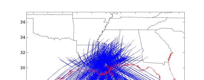
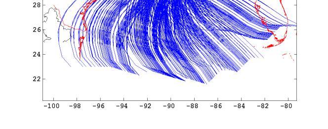
Monitoring Hurricane Rita Inland Storm Surge
 Monitoring Hurricane Rita Inland Storm Surge By Benton D. McGee, Roland W. Tollett, and Burl B. Goree Pressure transducers (sensors) are accurate, reliable, and cost-effective tools to measure and record
The Pontchartrain Maurepas Surge Consortium (LPMSC) Lake Sloshing Effect Preliminary Findings
 Lake Sloshing Effect Preliminary Findings") The Pontchartrain Maurepas Surge Consortium (LPMSC) Lake Sloshing Effect Preliminary Findings Lake Pontchartrain Basin Foundation John A. Lopez, Ph.D. with contributions from Dr. Joe Suhayda, Dr. Hal Needham,
The Pontchartrain Maurepas Surge Consortium (LPMSC) Lake Sloshing Effect Preliminary Findings Lake Pontchartrain Basin Foundation John A. Lopez, Ph.D. with contributions from Dr. Joe Suhayda, Dr. Hal Needham,
Loss Avoidance Study. St. Tammany Parish, Louisiana Hurricane Isaac, 2012 DR-4080-LA. Joint Field Office, Hazard Mitigation Branch, Baton Rouge, LA
 Loss Avoidance Study St. Tammany Parish, Louisiana Hurricane Isaac, 2012 DR-4080-LA Joint Field Office, Hazard Mitigation Branch, Baton Rouge, LA January 2013 Hurricane Isaac, August 2012 Losses Avoided
Miami-Dade County Overview
 Miami-Dade County Overview 2,000 square miles World s busiest cruise port 2.6 million residents Second busiest US airport for international travelers Gateway to the Caribbean and Latin America Natural
Lake Pontchartrain Basin Foundation saveourlake.org. Authors: John A. Lopez Ph.D., Mallory Davis, MSCE, EI, Rebecca Cope, BS
 Framework for Environmental Assessment of Alternative Flood Control Structures on Chef Menteur and Rigolets Passes within the Lake Pontchartrain Estuary, Southeast Louisiana Lake Pontchartrain Basin Foundation
Risk Analysis of a Protected Hurricane-Prone Region. I: Model Development
 Risk Analysis of a Protected Hurricane-Prone Region. I: Model Development Bilal M. Ayyub, P.E., F.ASCE 1 ; Jerry Foster, M.ASCE 2 ; and William L. McGill, P.E., M.ASCE 3 Abstract: A risk analysis methodology
HURRICANE NATE BRIEFING
 HURRICANE NATE BRIEFING 2:00 PM CDT Saturday, October 07, 2017 Prepared by: NWS NWSNewOrleans www.weather.gov/neworleans Situation Overview continues to intensify. It is now forecast to be a category 2
THE TRINITY RIVER VISION/ GATEWAY PARK / PANTHER ISLAND
 Quarterly Project Status Report May 2018 THE TRINITY RIVER VISION/ GATEWAY PARK / PANTHER ISLAND Flood Control Project Update Construction of North Main Street Bridge by TxDOT s bridge contractor, Texas
White River Update. Jeanne Stypula, Supervising Engineer. Advisory Committee Meeting April 26, 2016
 White River Update Jeanne Stypula, Supervising Engineer Advisory Committee Meeting April 26, 2016 Department of Natural Resources and Parks Water and Land Resources Division River and Floodplain Management
Modeling Nearshore Waves for Hurricane Katrina
 Modeling Nearshore Waves for Hurricane Katrina Jane McKee Smith US Army Engineer Research & Development Center Coastal and Hydraulics Laboratory Outline Introduction Modeling Approach Hurricane Katrina
Appendix 9 Risk Methodology
 Appendix 9 Risk Methodology Introduction This Appendix describes the risk analysis philosophy and methodology used to evaluate the performance of the New Orleans hurricane protection system. Probabilistic
Hurricane Katrina and Oil Spills: Impact on Coastal and Ocean Environments
 Archived version from NCDOCKS Institutional Repository http://libres.uncg.edu/ir/asu/ Pine, J. C. (June 2006). Hurricane Katrina and oil spills: Impact on coastal and ocean environments. Oceanography,
Remote Sensing / GIS Conference. The Louisiana Proposed Elevation for the Nation Business Plan Components
 Remote Sensing / GIS Conference 08 April 2008 The Louisiana Proposed Elevation for the Nation Business Plan Components David Gisclair, Louisiana Oil Spill Coordinators Office, Office of the Governor david.gisclair@la.gov
Loss Avoidance Study. Jefferson Parish, Louisiana Hurricane Isaac, 2012 DR-4080-LA. Joint Field Office, Hazard Mitigation Branch, Baton Rouge, LA
 Loss Avoidance Study Jefferson Parish, Louisiana Hurricane Isaac, 2012 DR-4080-LA Joint Field Office, Hazard Mitigation Branch, Baton Rouge, LA December 2012 Hurricane Isaac, August 2012 Losses Avoided
Hurricane Protection and Environmental Restoration
 November 16, 2010 Hurricane Protection and Environmental Restoration Presented by: Colonel (Ret.) Leonard Waterworth AGENDA How do we protect People/Environment/Economy 1900 Year Storm Hurricane Carla
This presentation is intended to provide some basic information about 3 subjects: First, Why might a flood protection system be needed for the
 This presentation is intended to provide some basic information about 3 subjects: First, Why might a flood protection system be needed for the urbanized, eastern part of Galveston Island? Second, What
Jefferson Parish GIS Hurricane Response Review. From the information given by A.J. Tapie, GIS Manager of Jefferson Parish, the use of
 Neil Dixon and Ryan Ziegelbauer URPL 969 3/10/2006 Jefferson Parish GIS Hurricane Response Review From the information given by A.J. Tapie, GIS Manager of Jefferson Parish, the use of GIS in the Parish
HURRICANE IVAN CHARACTERISTICS and STORM TIDE EVALUATION
 HURRICANE IVAN CHARACTERISTICS and STORM TIDE EVALUATION By Robert Wang and Michael Manausa Sponsored by Florida Department of Environmental Protection, Bureau of Beaches and Coastal Systems Submitted
Typhoon Maemi and Hurricane Katrina: Impacts and Aftermath. Typhoon Maemi: September 13, Typhoon Maemi Track and Characteristics
 Typhoon Maemi and Hurricane Katrina: Impacts and Aftermath Pierre Julien Un Ji Department of Civil Engineering Colorado State University Fort Collins, Colorado USA September, 2005 Typhoon Maemi: September
Extreme Changes to Barrier Islands Along the Central Gulf of Mexico Coast During Hurricane Katrina
 Extreme Changes to Barrier Islands Along the Central Gulf of Mexico Coast During Hurricane Katrina By Asbury Sallenger, Wayne Wright, Jeff Lillycrop, Peter Howd, Hilary Stockdon, Kristy Guy, and Karen
Probabilistic design of levee and floodwall heights for the Hurricane Protection System in the New Orleans area
 Probabilistic design of levee and floodwall heights for the Hurricane Protection System in the New Orleans area Mathijs van Ledden (Haskoning Inc.), Pat Lynett (Texas A&M), Don Resio (ERDC) and Nancy Powell
ACCELERATED BEACH EROSION ALONG THE UPPER TEXAS COAST
 ACCELERATED BEACH EROSION ALONG THE UPPER TEXAS COAST Young Hyun Park 1, Billy L. Edge 2 and Sehyun Cheon 3 The upper Texas coast has been severely eroded and beach erosion is going on. It is not extreme
Innovated Technological Trends in Highways. Flood Modelling & Evaluation of Impacts on Infrastructure
 Innovated Technological Trends in Highways Flood Modelling & Evaluation of Impacts on Infrastructure Dr. Waheed Uddin Professor and Director CAIT University of Mississippi Contributions from: CAIT and
Exploring the costs of sea level rise: should we focus on means or extremes?
 Exploring the costs of sea level rise: should we focus on means or extremes? Robert Muir-Wood Chief Research Officer, RMS AAAS Chicago Feb 16 th 2009 Change Points in Cat 3-5 Hurricane Numbers (the drivers
2006 & 2007 Pre-Hurricane Scenario Analyses
 2006 & 2007 Pre-Hurricane Scenario Analyses Executive Summary May 2007 Page 1 OF X FOR OFFICIAL USE ONLY 4 Public Availability to be Determined Under 5 U.S.C. 552 NOTE: Limited Distribution. Release of
Tropical Weather Briefing
 Tropical Weather Briefing August 28, 2012 700 AM CDT National Weather Service Weather Forecast Office Slidell, LA Current Satellite Tropical Storm Isaac Watches/Warnings Tropical Storm Isaac Track Guidance
General background on storm surge. Pat Fitzpatrick and Yee Lau Mississippi State University
 General background on storm surge Pat Fitzpatrick and Yee Lau Mississippi State University Storm surge is an abnormal rise of water associated with a cyclone, not including tidal influences Low pressure
MISSISSIPPI COASTAL IMPROVEMENTS
 MISSISSIPPI COASTAL IMPROVEMENTS PROGRAM (MsCIP) Comprehensive Barrier 237 27 200 237 27 200 Island 237 Restoration 27 200 Plan 80 9 27 252 74.59 255 255 255 0 0 0 63 63 63 3 32 22 239 65 53 0 35 20 2
FORECAST-BASED OPERATIONS AT FOLSOM DAM AND LAKE
 FORECAST-BASED OPERATIONS AT FOLSOM DAM AND LAKE 255 237 237 237 217 217 217 200 200 200 0 163 131 Bridging the Gap163Conference 255 0 132 255 0 163 122 The Dana on Mission Bay San Diego, CA January 28,
Chapter 16, Part Hurricane Paths. 2. Hurricane Paths. Hurricane Paths and Damage
 Chapter 16, Part 2 Hurricane Paths and Damage 1. Hurricane Paths Start over tropical water except South Atlantic and eastern South Atlantic, where water is too cold. Initially steered by easterly winds
Regional Sediment Management
 Regional Sediment Management Linda S. Lillycrop Program Manager Coastal Engineer US Army Engineer Research and Development Center Coastal and Hydraulics Laboratory Q AVG Coastal Resilience: The Environmental,
Sea Level Rise and Hurricane Florence storm surge research methodology
 Sea Level Rise and Hurricane Florence storm surge research methodology Hurricane Florence storm surge analysis was conducted using a variety of input sources. In order to determine the maximum storm surge
Inter State Large Navigable Rivers of the United States
 Inter State Large Navigable Rivers of the United States REVIEW OF NORTH AMERICAN BASINS: GREAT LAKES AND MISSISSIPPI RIVER HELEN A. BROHL, EXECUTIVE DIRECTOR US COMMITTEE ON THE MARINE TRANSPORTATION SYSTEM
An analysis of storm surge attenuation by wetlands using USGS, FEMA, and NASA data
 An analysis of storm surge attenuation by wetlands using USGS, FEMA, and NASA data Pat Fitzpatrick Geosystems Research Institute Mississippi State University Walter Peterson and Courtney Buckley NASA Marshall
Appendix 10 Reliability Modeling
 Appendix 10 Reliability Modeling Reliability analysis is that part of the risk study that leads to an evaluation of the conditional probability of failure (i.e., reliability or fragility) of structures,
Appendix 15 Computational Methodology
 Appendix 15 Computational Methodology Introduction This Appendix describes the process used by the risk team to determine the final loss exceedence values in the risk analysis. The process involved the
Rebuilding the Levees with GIS. David P. McDaniel Maik C. Flanagin Michele R. Aurand. Abstract
 Rebuilding the Levees with GIS David P. McDaniel Maik C. Flanagin Michele R. Aurand Abstract The USACE New Orleans District has historically segregated its levee data into individual survey files, CADD
Simulation of storm surge and overland flows using geographical information system applications
 Coastal Processes 97 Simulation of storm surge and overland flows using geographical information system applications S. Aliabadi, M. Akbar & R. Patel Northrop Grumman Center for High Performance Computing
ATLANTIC INTRACOASTAL WATERWAY NORFOLK DISTRICT. Joel F. Scussel, Operations Support Section Dismal Swamp Canal July 27, 2017
 ATLANTIC INTRACOASTAL WATERWAY 1 255 255 255 237 237 237 0 0 0 217 217 217 163 163 163 200 200 200 131 132 122 239 65 53 80 119 27 NORFOLK DISTRICT 110 135 120 252 174.59 112 92 56 62 102 130 102 56 48
A Hurricane Outlook for the 21st Century.
 A Hurricane Outlook for the 21st Century. Hugh Willoughby Florida International University Cat Winds Effects One 74-95 mph No real damage to building structures. Two Three Four Five 96-110 mph 111-130
THE NEED FOR AN ADDITIONAL SPILLWAY AT THE SANFORD DAM BOILING SPRING LAKES, NC. Presentation for The Brunswick County Commissioners April 20, 2015
 THE NEED FOR AN ADDITIONAL SPILLWAY AT THE SANFORD DAM BOILING SPRING LAKES, NC Presentation for The Brunswick County Commissioners April 20, 2015 The Sanford Dam Earth Dam constructed in 1961 Drainage
What s s New for 2009
 What s s New for 2009 Graphical Tropical Weather Outlook becomes operational Special Tropical Disturbance Statement replaced with Special Tropical Weather Outlook Tropical Cyclone Wind Field Graphic becomes
SCOUR CHARACTERIZATION DUE TO WATER FREE FALL
 SCOUR CHARACTERIZATION DUE TO WATER FREE FALL Abdolreza Osouli, Corresponding Author, Ph.D., P.E. Assistant Professor of Civil Engineering, Southern Illinois University at Edwardsville, Engineering Building,
HURRICANE SANDY LIMITED REEVALUATION REPORT UNION BEACH, NEW JERSEY DRAFT ENGINEERING APPENDIX SUB APPENDIX A PRELIMINARY FLOODWALL DESIGN
 HURRICANE SANDY LIMITED REEVALUATION REPORT UNION BEACH, NEW JERSEY DRAFT ENGINEERING APPENDIX SUB APPENDIX A PRELIMINARY FLOODWALL DESIGN March 2014Revised March 2015 UNITED STATES ARMY CORPS OF ENGINEERS
3Chapter Three: Rescue and Response
 17 16 Report Science Title and the Storms: the USGS Response to the Hurricanes of 2005 3Chapter Three: Rescue and Response This chapter documents the U.S. Geological Survey s (USGS) humanitarian rescue
Expert Report. Robert Glenn Bea, Ph.D., P.E.
 Expert Report of Robert Glenn Bea, Ph.D., P.E. Prepared for Plaintiffs in: Katrina Canal Breaches Consolidated Litigation [Civil Action Number: 05-4182 K (2)] United States District Court Eastern District
UPPER COSUMNES RIVER FLOOD MAPPING
 UPPER COSUMNES RIVER FLOOD MAPPING DRAFT BASIC DATA NARRATIVE FLOOD INSURANCE STUDY SACRAMENTO COUTY, CALIFORNIA Community No. 060262 November 2008 Prepared By: CIVIL ENGINEERING SOLUTIONS, INC. 1325 Howe
Water Level Statistics for Design of Transportation Facilities in Coastal Louisiana
 64 TRANSPORTATION RESEARCH RECORD 1483 Water Level Statistics for Design of Transportation Facilities in Coastal Louisiana JOSEPH SUtJAYDA, MOHAMED ALAWADY, AND BABAK NAGHAVI Results are presented of an
HURRICANE FRANCES CHARACTERISTICS and STORM TIDE EVALUATION
 HURRICANE FRANCES CHARACTERISTICS and STORM TIDE EVALUATION ((DRAFT)) By Robert Wang and Michael Manausa Sponsored by Florida Department of Environmental Protection, Bureau of Beaches and Coastal Systems
TROPICAL STORM NATE BRIEFING
 TROPICAL STORM NATE BRIEFING 2:00 PM CDT Friday, October 06, 2017 Prepared by: NWS NWSNewOrleans www.weather.gov/neworleans Situation Overview Track forecast has not changed since the 10 am advisory. Hurricane
Frank Revitte National Weather Service. Weather Forecast Office New Orleans/Baton Rouge
 Frank Revitte National Weather Service Weather Forecast Office New Orleans/Baton Rouge Above normal activity 17 Total Named Storms 7 Tropical Storms 4 Hurricanes 6 Major Hurricanes Not the most active,
Visualizing hurricanes
 Visualizing hurricanes NAME: DATE: Scientific visualization is an integral part of the process of simulating natural phenomena. In the computational sciences, the main goal is to understand the workings
Coastal Flood Risk Study Project for East Coast Central Florida Study Area
 Coastal Flood Risk Study Project for East Coast Central Florida Study Area St Lucie County, Florida Flood Risk Review Meeting March 28, 2017 Introductions Risk MAP Project Team FEMA Region IV BakerAECOM,
Measuring and GIS Referencing of Network Level Pavement Deterioration in Post-Katrina Louisiana March 19, 2008
 Infrastructure Data Collection Solutions Measuring and GIS Referencing of Network Level Pavement Deterioration in Post-Katrina Louisiana March 19, 2008 Hurricane Katrina August 2005 I-10 I-610 West End
Local Flood Hazards. Click here for Real-time River Information
 Local Flood Hazards Floods of the White River and Killbuck Creek are caused by runoff from general, and/or intense rainfall. Other areas of flooding concern are from the Boland Ditch and Pittsford Ditch.
THC-T-2013 Conference & Exhibition
 Modeling of Shutter Coastal Protection against Storm Surge for Galveston Bay C. Vipulanandan, Ph.D., P.E., Y. Jeannot Ahossin Guezo and and B. Basirat Texas Hurricane Center for Innovative Technology (THC-IT)
Agricultural Outlook Forum Presented: February 17, 2006 THE SCIENCE BEHIND THE ATLANTIC HURRICANES AND SEASONAL PREDICTIONS
 Agricultural Outlook Forum Presented: February 17, 2006 THE SCIENCE BEHIND THE ATLANTIC HURRICANES AND SEASONAL PREDICTIONS Gerald Bell Meteorologist, National Centers for Environmental Prediction NOAA,
TROPICAL STORM NATE BRIEFING
 TROPICAL STORM NATE BRIEFING 10:30 AM CDT Friday, October 06, 2017 Prepared by: NWS NWSNewOrleans www.weather.gov/neworleans Situation Overview Track forecast has shifted slightly eastward. Hurricane Watch
Coastal and Hydraulics Laboratory
 ERDC/CHL TR-10-7 Flood-Side Wave Erosion of Earthen Levees: Present State of Knowledge and Assessment of Armoring Necessity Steven A. Hughes August 2010 Coastal and Hydraulics Laboratory Approved for public
Geotechnical Reconnaissance of the Mississippi River Delta Flood-protection System After Hurricane Katrina
 Geotechnical Reconnaissance of the Mississippi River Delta Flood-protection System fter Hurricane Katrina y Ronaldo Luna, David Summers, David Hoffman, J. David Rogers, dam Sevi, and Emitt C. Witt This
ANALYSIS OF FLOW CONDITIONS AT THE IHNC-GIWW SECTOR GATE
 ANALYSIS OF FLOW CONDITIONS AT THE IHNC-GIWW SECTOR GATE SLFPA-E October 2016 Motivation SLFPA-E has observed high velocities within the opening of the GIWW sector gate at the surge barrier. Concern about
Coastal Litigation in the Context of Science Literacy
 Coastal Litigation in the Context of Science Literacy Chris McLindon New Orleans Geological Society February 6, 7 Science Literacy The value of community participation in scientific research is widely