Hurricanes are intense vortical (rotational) storms that develop over the tropical oceans in regions of very warm surface water.
|
|
|
- Darlene Walton
- 5 years ago
- Views:
Transcription
1 Hurricanes: Observations and Dynamics Houze Section Holton Section 9.7. Emanuel, K. A., 1988: Toward a general theory of hurricanes. American Scientist, 76, (web link). Definition: Hurricanes are intense vortical (rotational) storms that develop over the tropical oceans in regions of very warm surface water. Hurricanes are called typhoons when they occur over the western Pacific. Before they reach the hurricane/typhoon strength (when winds near the center of vortex is > 32 m/s), they are called tropical cyclones. Horizontal scale ~ 500 km, vertical depth ~ km Although hurricanes have radial scales of several hundred kilometers, the horizontal scale of the region of intense convection and strong winds in a hurricane is typically only about 100 km in radius. Thus, it is reasonable to classify hurricanes as mesoscale systems. 1
.")
2 Regions of formation: Between 5 and 20 latitude, but not at the equator (need Coriolis force) Sea surface temperature > 26.5 (80F). Moderately conditionally unstable atmosphere Weak vertical shear Locations of formation over a 20-year period: 2

3 Tracks of tropical cyclones and sea-surface temperature 3

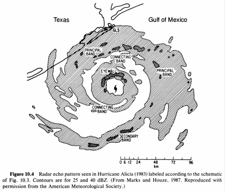
4 General Patterns of Cloud and Precipitation in Hurricanes 4
5 5
6 6
7 Major Features: Cyclonic spiral convergent bands at the low-levels and anticyclonic outward spiral cirriform clouds at the upper levels Hurricane eye typically a cloud free center of km in diameter Eye wall deep convection surrounding the eye. Slopes outward with height. Two-eye-wall structures had been observed. Rainbands typically spiral bands of clouds outside the eye wall. Often propagate outwards from the eye. Reflectivity even in eye wall, R max ~ dbz typical. In server thunderstorms, R ~ dbz. 7

8 The winds - In the horizontal cross-section 8
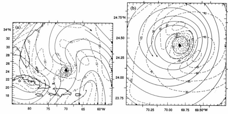
9 9
10 Horizontal Distribution of winds ~ symmetric in terms of system relative winds Asymmetric in total winds due to the hurricane motion stronger on the "forward" side. V V Vorticity = + in cylindrical coordinates. R r 50 m/ s 3 1 Typical value ~ = 1 10 s. 50km 10

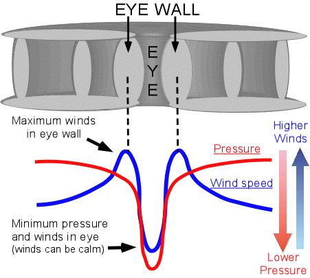
11 The winds - In the vertical cross-section radial wind tangential wind 11
12 Maximum tangential wind at the edge of eye wall Max speed ~ km above sfc Vertical shear < 0.0 since the thermal wind opposes the observed wind throughout the troposphere. Why because hurricanes have warm code (see next figure) The vertical shear is relatively weak, due to vertical momentum mixing by Cb clouds 12
13 13
14 Thermodynamic Structure 14
15 Temperature departure from the mean Note: ~ warmer inside eye due to subsidence Warm core causes surface low-pressure (hydrostatic balance) θ e in hurricane more potentially stable than outside (since instability has been released) θ e in eye much higher (15-30 more) (a) If one starts with θ e = 350K and go up along moist adiabat and p sfc = 1000mb (typical for most tropical disturbances), we can show p sfc = θ e. (b) Air from outside hurricane (where p ~ 1000mb) going towards the center (where p ~ 950 mb) should normally cool adiabatically but observed temperature stays the same or increases slight. This is due to sensible heat flux from the sea surface θ e increases substantially. The air-sea interaction theory of Emanuel further points out that the latent-heat flux from the sea surface as the air flow towards the center at large wind speed is another major energy source. Presence of warm-cored eye is a key feature of hurricanes, which causes pressure drop at the center. 15
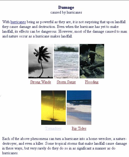
16 Landfall greater frictional convergence convection may actually intensify because of enhanced Ekman pumping effect (but less high θ e air from the surface cause pressure to rise) wind damage from large scale tangential winds but also from convective downdrafts weak to moderate tornadoes are common after landfall sfc winds now about 50% of 1 km winds (vs 70% over ocean) so vertical shear increases significantly CAPE in hurricanes relatively small Damages: Strong winds, convective gusts Sea level rise by 1-2 m due to low pressure Storm surge ~ 2 10 m, strongest in the right front quadrant Waves Tornadoes Flooding from rains 16
17 17
18 18
19 Hurricane Dynamics Hurricane vortex cannot be understood without including the rotation of the earth in the vorticity balance. The rapid rotation is produced by concentration of the vertical component of absolute vorticity by vortex stretching/horizontal convergence. Maximum tangential wind speeds range typically from 50 to 100 m s -1. Centrifugal force cannot be neglected compared to the Coriolis force. The azimuthal (tangential) velocity in a steady-state hurricane is in gradient wind balance with the radial pressure gradient force. Hydrostatic balance holds on the hurricane scale, which implies that the vertical shear of the azimuthal (tangential ) velocity is a function of the radial temperature gradient (thermal wind balance) The kinetic energy of hurricanes is maintained in the presence of boundary layer dissipation by conversion of latent heat energy acquired from the underlying ocean. This potential energy conversion is carried out by a transverse secondary circulation associated with the hurricane, as shown below: 19
20 20
21 Hurricane Formation Theories Two main theories: CISK (Conditional Instability of the Second Kind) Theory and the Air-sea interaction theory CISK (Conditional Instability of the Second Kind) Theory (1960's 1970's) Represents a cooperation between convection and large-scale convergence: Weak disturbances containing vorticity Ekman layer (BL) convergence through Ekman pumping Increased convection Latent heat release Temperature increase Sfc pressure falls Increased vorticity Increased convergence A feedback loop - instability Linear analysis to capture the above instability process has not been very successful, however, since there is little evidence that such interaction leads to a growth rate maximum on the observed scale of hurricanes. 21
22 Another problem is, as is pointed out by Emanuel (handout) that the tropical atmosphere is on average conditionally statically neutral to the low-level convective parcel, when the water loading is included. Therefore net buoyancy within a convective cloud is small relative to its environment. It is believed that it is the temperature different between the hurricane center and the surrounding environment that drives the hurricane circulation. 22
23 Air-sea interaction theory (Emanuel 1988, handout) A dramatically different view has been proposed, mainly by Emanuel since late 80's which is referred to as the airsea interaction theory. It is based on the fact that the potential energy for hurricanes arises from the thermodynamic disequilibrium between the atmosphere and the underlying ocean. Since the subcloud boundary layer is unsaturated, the BL air has a potential for significant increase in q v therefore θ e (or moist entropy), therefore the real energy source is believed to be the warm surface of the topical oceans. 23
24 The air-sea interaction theory views energetics of the steady-state hurricane as an example of a Carnot cycle heat engine in which heat is absorbed (in the form of water vapor) from the ocean at temperature T s and expelled by radiative cooling to space at temperature T o at the top of the storm. With this theory, the circulation is driven by T between region 1 (+5) and region 2. The temperature in region 1 is higher because of increase of water vapor of BL air as it flowed inward towards the eye and that in region 5 due to subsidence. Quantitative investigation of energy source: Hoe does total moist entropy increase? Recall (dry) entropy ds = C p dln(θ) p0 where θ = T p R / C p > dlnθ = dln T R/ C dln p or Cdlnθ = CdlnT Rdln p. p p p Now, for moist processes, we can show that Ldws Cd p lnθ = (equation for moist adiabat) T 24
25 so, moist entropy is defined as Ldws ds = Cpd lnt + R d ln p. T As air moves toward the hurricane center, entropy increases due to increase in moisture (dw s term) via latent heat fluxes and p decrease (but temperature stays the same as sensible heat flux from the ocean balances the expected adiabatic cooling isothermal expansion, heat input at high T). As the air ascends in the eye wall region (region 1 in Figure), s is conserved. S decreases outside the hurricane at the upper-levels due to radiative cooling (at point O to O'). Carnot's Theorem says total mechanical energy of the system is E = ε Ts ( sc sa) (c for center and a for ambient, outside) where ε is the thermodynamic efficiency of the heat engine. Ts T ε = T s o Since T s ~ 300 K and T o ~ 200 K, the efficiency of the heat engine can be as high as 30%, i.e., as much as 30% heat acquired at the low levels can be converted into kinetic energy. Since the primary balance in hurricane BL is between PGF and frictional dissipation. In a steady state hurricane, the mechanical energy generated, E, balances frictional dissipation. 25
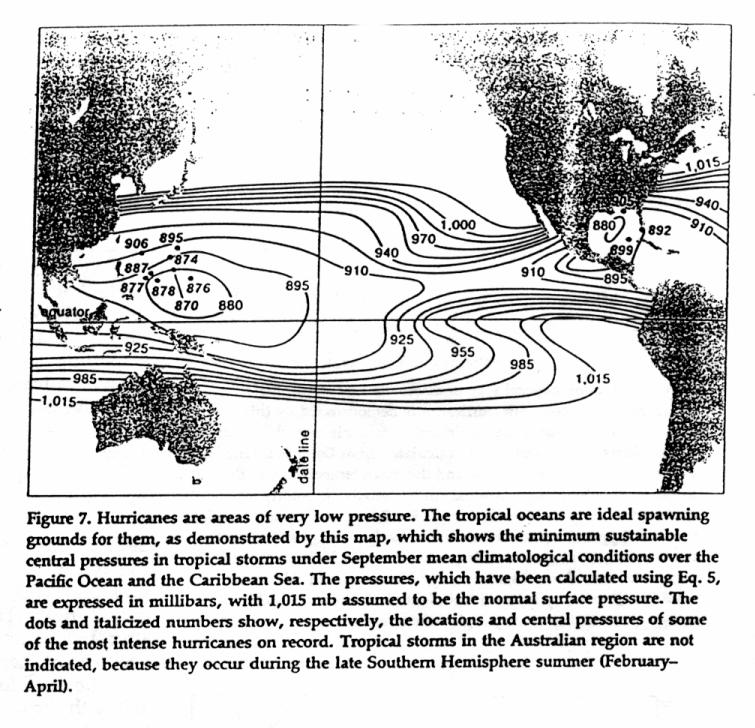
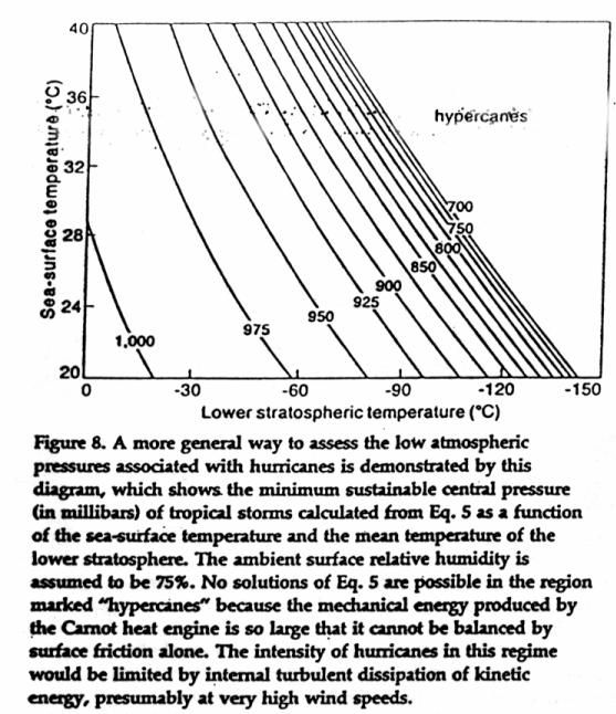
26 Equating the work done by the PGF to E --> c RT dp = ε T s( s c s a) a p pc or RTs ln = εts( sc sa) p a Solve for p c gives the minimum possible central pressure. Fig.7 in Emanuel is obtained this way. Since the air-sea interaction model depends on the sea surface fluxes, which depend on the wind speed. It has bee demonstrated in a numerical model that the initial vortex has to have sufficient intensity (wind speed is large enough) a hurricane to form. See Fig.9. The real difficulty is in determining which tropical disturbance can gain sufficient intensify to develop into a hurricane. This is a still an unsolved problem. 26
27 27
28 28
29 29
30 References: Emanuel, K. A., 1986: An air -sea interaction theory for tropical cyclones. Part I: Steady state maintenance. J. Atmos. Sci., 43, Rotunno, R., and K. A. Emanuel, 1987: An air-sea interaction theory for tropical cyclones. Part II: An evolutionary study using a hydrostatic axisymmetric numerical model. J. Atmos. Sci., 44,
Tropical Cyclone Intensification
 Tropical Cyclone Intensification Theories for tropical cyclone intensification and structure CISK (Charney and Eliassen 1964) Cooperative Intensification Theory (Ooyama 1969). WISHE (Emanuel 1986, Holton
- tornadoes. Further Reading: Chapter 08 of the text book. Outline. -tropical storms. -Storm surge
 (1 of 12) Further Reading: Chapter 08 of the text book Outline - tornadoes -tropical storms -Storm surge (2 of 12) Introduction Previously, We talked about fronts and their relationship to air masses Also
Lectures on Tropical Cyclones
 Lectures on Tropical Cyclones Chapter 1 Observations of Tropical Cyclones Outline of course Introduction, Observed Structure Dynamics of Mature Tropical Cyclones Equations of motion Primary circulation
Hurricanes. Hurricanes are large, tropical storm systems that form and develop over the warm waters near the equator.
 Hurricanes Hurricanes are large, tropical storm systems that form and develop over the warm waters near the equator. They are responsible for weather that can devastate entire communities: Heavy rain --
- tornadoes. Further Reading: Chapter 08 of the text book. Outline. - cyclones and anti-cyclones. -tropical storms. -Storm surge
 (1 of 16) Further Reading: Chapter 08 of the text book Outline - cyclones and anti-cyclones - tornadoes -tropical storms -Storm surge (2 of 16) Introduction Previously, We talked about fronts and their
Inner core dynamics: Eyewall Replacement and hot towers
 Inner core dynamics: Eyewall Replacement and hot towers FIU Undergraduate Hurricane Internship Lecture 4 8/13/2012 Why inner core dynamics is important? Current TC intensity and structure forecasts contain
ESCI 344 Tropical Meteorology Lesson 11 Tropical Cyclones: Formation, Maintenance, and Intensification
 ESCI 344 Tropical Meteorology Lesson 11 Tropical Cyclones: Formation, Maintenance, and Intensification References: A Global View of Tropical Cyclones, Elsberry (ed.) Global Perspectives on Tropical Cylones:
Tropical Cyclones. Objectives
 Tropical Cyclones FIU Undergraduate Hurricane Internship Lecture 2 8/8/2012 Objectives From this lecture you should understand: Global tracks of TCs and the seasons when they are most common General circulation
Divergence, Spin, and Tilt. Convergence and Divergence. Midlatitude Cyclones. Large-Scale Setting
 Midlatitude Cyclones Equator-to-pole temperature gradient tilts pressure surfaces and produces westerly jets in midlatitudes Waves in the jet induce divergence and convergence aloft, leading to surface
Hurricanes. April 14, 2009
 Tropical Weather & Hurricanes Chapter 15 April 14, 2009 Tropical meteorology Tropics characterized by seasonal wet and drier periods- wet when sun is nearly overhead at noon and inter-tropical convergence
Chapter 24. Tropical Cyclones. Tropical Cyclone Classification 4/19/17
 Chapter 24 Tropical Cyclones Tropical Cyclones Most destructive storms on the planet Originate over tropical waters, but their paths often take them over land and into midlatitudes Names Hurricane (Atlantic
Chapter 24 Tropical Cyclones
 Chapter 24 Tropical Cyclones Tropical Weather Systems Tropical disturbance a cluster of thunderstorms about 250 to 600 km in diameter, originating in the tropics or sub-tropics Tropical depression a cluster
The Tropical Atmosphere: Hurricane Incubator
 The Tropical Atmosphere: Hurricane Incubator Images from journals published by the American Meteorological Society are copyright AMS and used with permission. A One-Dimensional Description of the Tropical
Hurricane: an organized tropical storm system featuring vigorous convection and sustained winds in excess of 64 knots (74 mph)
") Hurricane: an organized tropical storm system featuring vigorous convection and sustained winds in excess of 64 knots (74 mph) The storms have different names, depending on where they form: Western Hemisphere:
Hurricane: an organized tropical storm system featuring vigorous convection and sustained winds in excess of 64 knots (74 mph) The storms have different names, depending on where they form: Western Hemisphere:
ESCI 241 Meteorology Lesson 19 Tropical Cyclones Dr. DeCaria
 ESCI 241 Meteorology Lesson 19 Tropical Cyclones Dr. DeCaria READING: Chapter 16 GENERAL A tropical cyclone is a large, low-pressure system that forms over the tropical oceans. Tropical cyclones are classified
地球系统科学前沿讲座 台风研究现状和问题 林岩銮
 地球系统科学前沿讲座 台风研究现状和问题 林岩銮 2013.3.18 Satellite image of Hurricane Floyd approaching the east coast of Florida in 1999. The image has been digitally enhanced to lend a three-dimensional perspective. Credit:
Tropical Cyclones: Steady State Physics
 Tropical Cyclones: Steady State Physics Energy Production Carnot Theorem: Maximum efficiency results from a particular energy cycle: Isothermal expansion Adiabatic expansion Isothermal compression Adiabatic
On the effect of forward shear and reversed shear baroclinic flows for polar low developments. Thor Erik Nordeng Norwegian Meteorological Institute
 On the effect of forward shear and reversed shear baroclinic flows for polar low developments Thor Erik Nordeng Norwegian Meteorological Institute Outline Baroclinic growth a) Normal mode solution b) Initial
Lecture 18 Hurricanes
 Lecture 18 Hurricanes Part I Structure and Climatology What is a hurricane? What is the structure or anatomy of a hurricane? How to build a hurricane - hurricane energy Hurricane climatology - when and
Thermodynamic and Flux Observations of the Tropical Cyclone Surface Layer
 Thermodynamic and Flux Observations of the Tropical Cyclone Surface Layer 1. INTRODUCTION Alex M. Kowaleski and Jenni L. Evans 1 The Pennsylvania State University, University Park, PA Understanding tropical
Foundations of Earth Science, 6e Lutgens, Tarbuck, & Tasa
 Foundations of Earth Science, 6e Lutgens, Tarbuck, & Tasa Weather Patterns and Severe Weather Foundations, 6e - Chapter 14 Stan Hatfield Southwestern Illinois College Air masses Characteristics Large body
Weather Systems III: Thunderstorms and Twisters
 Weather Systems III: Thunderstorms and Twisters Review 1. Definition of airmasses? Bergeron classification of air masses 2. Surface weather analysis: Station model, wind speed code, present weather 3.
Introduction to Meteorology & Climate. Climate & Earth System Science. Atmosphere Ocean Interactions. A: Structure of the Ocean.
 Climate & Earth System Science Introduction to Meteorology & Climate MAPH 10050 Peter Lynch Peter Lynch Meteorology & Climate Centre School of Mathematical Sciences University College Dublin Meteorology
11/19/14. Chapter 11: Hurricanes. The Atmosphere: An Introduction to Meteorology, 12 th. Lutgens Tarbuck
 Chapter 11: Hurricanes The Atmosphere: An Introduction to Meteorology, 12 th Lutgens Tarbuck Lectures by: Heather Gallacher, Cleveland State University! Hurricanes: " Hurricanes are intense centers of
Self-Stratification of Tropical Cyclone Outflow. Part II: Implications for Storm Intensification
 988 J O U R N A L O F T H E A T M O S P H E R I C S C I E N C E S VOLUME 69 Self-Stratification of Tropical Cyclone Outflow. Part II: Implications for Storm Intensification KERRY EMANUEL Program in Atmospheres,
Thunderstorms. Stages in the development of a thunderstorm
 Severe Weather Outcomes: S2-4-04 Explain the formation and dynamics of selected severe weather phenomena... S2-4-05 Collect, interpret, and analyze meteorological data related to a severe weather event.
Hurricanes Part I Structure and Climatology by Professor Steven Businger. Hurricane Katrina
 Hurricanes Part I Structure and Climatology by Professor Steven Businger Hurricane Katrina Hurricanes Part I Structure and Climatology by Professor Steven Businger What is a hurricane? What is the structure
Clouds and turbulent moist convection
 Clouds and turbulent moist convection Lecture 2: Cloud formation and Physics Caroline Muller Les Houches summer school Lectures Outline : Cloud fundamentals - global distribution, types, visualization
5 Atmospheric Disturbances 7 1.Cyclones- tropical and temperate and associated weather conditions. 2.Anticyclones and associated weather conditions.
 5 Atmospheric Disturbances 7 1.Cyclones- tropical and temperate and associated weather conditions. 2.Anticyclones and associated weather conditions. atmospheric disturbances (weather systems) that are
Tropical Cyclone Genesis: What we know, and what we don t!
 Tropical Cyclone Genesis: What we know, and what we don t! Allison Wing! NSF Postdoctoral Research Fellow! Lamont-Doherty Earth Observatory! Columbia University! Overview! Climatology! What We Know! Theories!
Hurricanes: Their physics and relationship to climate. Kerry Emanuel Massachusetts Institute of Technology
 Hurricanes: Their physics and relationship to climate Kerry Emanuel Massachusetts Institute of Technology Topics Overview of Tropical Cyclones Tropical Cyclone Physics What have TCs been like in the past,
SEVERE AND UNUSUAL WEATHER
 SEVERE AND UNUSUAL WEATHER Basic Meteorological Terminology Adiabatic - Referring to a process without the addition or removal of heat. A temperature change may come about as a result of a change in the
Adiabatic expansion Isothermal compression Adiabatic compression
 Tropical Cyclones: Steady State Physics 1 Energy Production 2 Carnot Theorem: Maximum efficiency results from a pa rticular energy e cycle: Isothermal expansion Adiabatic expansion Isothermal compression
Tuesday, September 13, 16
 Weather Weather State Objectives 4.c, 4.d, 4.h. Discussion What are some ways in which weather affects your everyday life? Discussion What are some ways in which weather affects your everyday life? What
Annual Number of Peer Reviewed Articles with Hurricane or Tropical Cyclone in their Titles, according to Meteorological and Geoastrophysical
 Hurricanes and Climate Kerry Emanuel Program in Atmospheres, Oceans, and Climate MIT Program Potential Intensity Role of potential ti li intensity it in storm intensity it Role of potential intensity in
USING PROGRAM HURRICANE. Download all the files, including the (empty) output subdirectory into a new folder on your machine.
 output subdirectory into a new folder on your machine.") USING PROGRAM HURRICANE Download all the files, including the (empty) output subdirectory into a new folder on your machine. QuickStart: First compile hurr.f. Modify the first column of the input file
USING PROGRAM HURRICANE Download all the files, including the (empty) output subdirectory into a new folder on your machine. QuickStart: First compile hurr.f. Modify the first column of the input file
Unit 5 Part 2 Test PPT
 Unit 5 Part 2 Test PPT Standard 1: Air Masses Air Mass An air mass is an immense body of air that is characterized by similar temperatures and amounts of moisture at any given altitude When an air mass
The Formation of Tropical Cyclones 1
 The Formation of Tropical Cyclones 1 David J. Raymond Physics Department and Geophysical Research Center New Mexico Tech Socorro, NM, USA 1 Work supported by US National Science Foundation and Office of
The dynamics of high and low pressure systems
 The dynamics of high and low pressure systems Newton s second law for a parcel of air in an inertial coordinate system (a coordinate system in which the coordinate axes do not change direction and are
I. Air Masses A. Defined: large body of air, 1600 km or more across, with similar temperature and moisture at similar altitudes 1.
 I. Air Masses A. Defined: large body of air, 1600 km or more across, with similar temperature and moisture at similar altitudes 1. Brings these characteristics with it as it moves to different areas 2.
Section 13-1: Thunderstorms
 Section 13-1: Thunderstorms Chapter 13 Main Idea: The intensity and duration of thunderstorms depend on the local conditions that create them. Air-mass thunderstorm Mountain thunderstorm Sea-breeze thunderstorm
1. Sea Surface Temperatures (SSTs) > 27 and extending to some depth.
 > 27 and extending to some depth.") Formation Factors for Hurricanes 1. Sea Surface Temperatures (SSTs) > 27 and extending to some depth. 2. Location >5 away from the equator (usually 10 ). Coriolis force is necessary for rotation. 3. High
Formation Factors for Hurricanes 1. Sea Surface Temperatures (SSTs) > 27 and extending to some depth. 2. Location >5 away from the equator (usually 10 ). Coriolis force is necessary for rotation. 3. High
Hurricane Science Tutorial. Kerry Emanuel Lorenz Center, MIT
 Hurricane Science Tutorial Kerry Emanuel Lorenz Center, MIT Why Should You Care? Forecasting Much progress in social science of response to warnings, requests to evacuate, etc. Forecasters are ambassadors
Chapter 14 Thunderstorm Fundamentals
 Chapter overview: Thunderstorm appearance Thunderstorm cells and evolution Thunderstorm types and organization o Single cell thunderstorms o Multicell thunderstorms o Orographic thunderstorms o Severe
Air Masses, Weather Systems and Hurricanes
 The Earth System - Atmosphere IV Air Masses, Weather Systems and Hurricanes Air mass a body of air which takes on physical characteristics which distinguish it from other air. Classified on the basis of
DEPARTMENT OF EARTH & CLIMATE SCIENCES SAN FRANCISCO STATE UNIVERSITY EARTH 365. Fall 2018 Test #2. November :00pm 7:15pm
 1 DEPARTMENT OF EARTH & CLIMATE SCIENCES SAN FRANCISCO STATE UNIVERSITY EARTH 365 Fall 2018 Test #2 November 6 2018 6:00pm 7:15pm 200 points (4 points each answer) Answer on the answer sheet provided.
The Effect of Sea Spray on Tropical Cyclone Intensity
 The Effect of Sea Spray on Tropical Cyclone Intensity Jeffrey S. Gall, Young Kwon, and William Frank The Pennsylvania State University University Park, Pennsylvania 16802 1. Introduction Under high-wind
(April 7, 2010, Wednesday) Tropical Storms & Hurricanes Part 2
 Tropical Storms & Hurricanes Part 2") Lecture #17 (April 7, 2010, Wednesday) Tropical Storms & Hurricanes Part 2 Hurricane Katrina August 2005 All tropical cyclone tracks (1945-2006). Hurricane Formation While moving westward, tropical disturbances
Lecture #17 (April 7, 2010, Wednesday) Tropical Storms & Hurricanes Part 2 Hurricane Katrina August 2005 All tropical cyclone tracks (1945-2006). Hurricane Formation While moving westward, tropical disturbances
Chapter 3 Convective Dynamics
 Chapter 3 Convective Dynamics Photographs Todd Lindley 3.2 Ordinary or "air-mass storm 3.2.1. Main Characteristics Consists of a single cell (updraft/downdraft pair) Forms in environment characterized
IV. Atmospheric Science Section
 EAPS 100 Planet Earth Lecture Topics Brief Outlines IV. Atmospheric Science Section 1. Introduction, Composition and Structure of the Atmosphere Learning objectives: Understand the basic characteristics
WaVaCS summerschool Autumn 2009 Cargese, Corsica
 Introduction Part I WaVaCS summerschool Autumn 2009 Cargese, Corsica Holger Tost Max Planck Institute for Chemistry, Mainz, Germany Introduction Overview What is a parameterisation and why using it? Fundamentals
True or false: The atmosphere is always in hydrostatic balance. A. True B. False
 Clicker Questions and Clicker Quizzes Clicker Questions Chapter 7 Of the four forces that affect the motion of air in our atmosphere, which is to thank for opposing the vertical pressure gradient force
Numerical Simulation of a Quasi-Tropical Cyclone over the Black Sea
 ISSN -, Izvestiya, Atmospheric and Oceanic Physics,, Vol., No., pp.. Pleiades Publishing, Ltd.,. Original Russian Text V.V. Efimov, M.V. Shokurov, D.A. Yarovaya,, published in Izvestiya AN. Fizika Atmosfery
Dynamics of the Zonal-Mean, Time-Mean Tropical Circulation
 Dynamics of the Zonal-Mean, Time-Mean Tropical Circulation First consider a hypothetical planet like Earth, but with no continents and no seasons and for which the only friction acting on the atmosphere
Part 9. Tropical Cyclones
 Part 9. Tropical Cyclones 9.1 Introduction The tropical cyclone is known as the hurricane in the north Atlantic and eastern north Pacific, typhoon in the western north Pacific, and just cyclone in the
Radiative equilibrium Some thermodynamics review Radiative-convective equilibrium. Goal: Develop a 1D description of the [tropical] atmosphere
![Radiative equilibrium Some thermodynamics review Radiative-convective equilibrium. Goal: Develop a 1D description of the [tropical] atmosphere](/thumbs/72/66535634.jpg "Radiative equilibrium Some thermodynamics review Radiative-convective equilibrium. Goal: Develop a 1D description of the [tropical] atmosphere") Radiative equilibrium Some thermodynamics review Radiative-convective equilibrium Goal: Develop a 1D description of the [tropical] atmosphere Vertical temperature profile Total atmospheric mass: ~5.15x10
Radiative equilibrium Some thermodynamics review Radiative-convective equilibrium Goal: Develop a 1D description of the [tropical] atmosphere Vertical temperature profile Total atmospheric mass: ~5.15x10
Solutions to Comprehensive Final Examination Given on Thursday, 13 December 2001
 Name & Signature Dr. Droegemeier Student ID Meteorology 1004 Introduction to Meteorology Fall, 2001 Solutions to Comprehensive Final Examination Given on Thursday, 13 December 2001 BEFORE YOU BEGIN!! Please
Chapter 1. Introduction
 Chapter 1. Introduction In this class, we will examine atmospheric phenomena that occurs at the mesoscale, including some boundary layer processes, convective storms, and hurricanes. We will emphasize
Boundary layer equilibrium [2005] over tropical oceans
![Boundary layer equilibrium [2005] over tropical oceans](/thumbs/96/128963638.jpg "Boundary layer equilibrium [2005] over tropical oceans") Boundary layer equilibrium [2005] over tropical oceans Alan K. Betts [akbetts@aol.com] Based on: Betts, A.K., 1997: Trade Cumulus: Observations and Modeling. Chapter 4 (pp 99-126) in The Physics and Parameterization
Boundary layer equilibrium [2005] over tropical oceans Alan K. Betts [akbetts@aol.com] Based on: Betts, A.K., 1997: Trade Cumulus: Observations and Modeling. Chapter 4 (pp 99-126) in The Physics and Parameterization
Meteorology Lecture 21
 Meteorology Lecture 21 Robert Fovell rfovell@albany.edu 1 Important notes These slides show some figures and videos prepared by Robert G. Fovell (RGF) for his Meteorology course, published by The Great
Large-Eddy Simulations of Tropical Convective Systems, the Boundary Layer, and Upper Ocean Coupling
 DISTRIBUTION STATEMENT A. Approved for public release; distribution is unlimited. Large-Eddy Simulations of Tropical Convective Systems, the Boundary Layer, and Upper Ocean Coupling Eric D. Skyllingstad
Tropical Cyclone Formation
 Tropical Cyclone Formation Introduction Previously, we discussed large-scale conditions believed to be necessary for tropical cyclone development to occur. Now, we focus on describing two physical processes:
Introduction to Mesoscale Meteorology
 Introduction to Mesoscale Meteorology Overview Scale Definitions Synoptic Synoptic derived from Greek synoptikos meaning general view of the whole. Also has grown to imply at the same time or simultaneous.
Hurricanes and Tropical Weather Systems:
 Hurricanes and Tropical Weather Systems: An influence on weather in parts of the USA Meteorology 411 Iowa State University Week 2 Bill Gallus Classification/Terminology Tropical Disturbance enhanced convection
Dependence of tropical cyclone intensification rate on sea surface temperature
 Quarterly Journal of the Royal Meteorological Society Q. J. R. Meteorol. Soc. 141: 1 11 (2015) Dependence of tropical cyclone intensification rate on sea surface temperature Nina Crnivec a, Roger K. Smith
Mid-Latitude Cyclones and Fronts. Lecture 12 AOS 101
 Mid-Latitude Cyclones and Fronts Lecture 12 AOS 101 Homework 4 COLDEST TEMPS GEOSTROPHIC BALANCE Homework 4 FASTEST WINDS L Consider an air parcel rising through the atmosphere The parcel expands as it
Transient/Eddy Flux. Transient and Eddy. Flux Components. Lecture 7: Disturbance (Outline) Why transients/eddies matter to zonal and time means?
 Why transients/eddies matter to zonal and time means?") Lecture 7: Disturbance (Outline) Transients and Eddies Climate Roles Mid-Latitude Cyclones Tropical Hurricanes Mid-Ocean Eddies (From Weather & Climate) Flux Components (1) (2) (3) Three components contribute
Lecture 7: Disturbance (Outline) Transients and Eddies Climate Roles Mid-Latitude Cyclones Tropical Hurricanes Mid-Ocean Eddies (From Weather & Climate) Flux Components (1) (2) (3) Three components contribute
Reconstruction of Thermodynamic Cycles in a High-Resolution Simulation of a Hurricane
 OCTOBER 2017 P A U L U I S A N D Z H A N G 3367 Reconstruction of Thermodynamic Cycles in a High-Resolution Simulation of a Hurricane OLIVIER M. PAULUIS Courant Institute of Mathematical Sciences, New
b. The boundary between two different air masses is called a.
 NAME Earth Science Weather WebQuest Part 1. Air Masses 1. Find out what an air mass is. http://okfirst.mesonet.org/train/meteorology/airmasses.html a. What is an air mass? An air mass is b. The boundary
Hurricane potential intensity from an energetics point of view
 Q. J. R. Meteorol. Soc. (2004), 130, pp. 2629 2648 doi: 10.1256/qj.03.65 Hurricane potential intensity from an energetics point of view By WEIXING SHEN, National Centers for Environmental Prediction, Camp
Hurricane Intensity: Governing Factors and Forecasting Challenges. EAS 470 Final Paper Allison Wing
 Hurricane Intensity: Governing Factors and Forecasting Challenges EAS 470 Final Paper Allison Wing Tropical cyclones are undoubtedly among the mostly deadly and destructive natural phenomena found on Earth
Tropical Storms & Hurricanes Part 1. August 1992
 Lecture #16 (April 5, 2010, Monday) Tropical Storms & Hurricanes Part 1 August 1992 Tracks of rain accumulation & clouds from Hurricane Rita September 2005 Tropical Cyclones Around the Globe Why none here?
Chapter 8 cont. Clouds and Storms
 Chapter 8 cont. Clouds and Storms Spring 2007 Clouds and Storms Clouds cover ~ 50% of earth at any time. Clouds are linked to a number of condensation processes. Cloud morphology, cloud types, associated
Effects Of Cumulus Convection On Rapidly Intensifying Cyclones
 Effects Of Cumulus Convection On Rapidly Intensifying Cyclones M.K. Yau and R. R. Rogers Department of Atmospheric and Oceanic Sciences McGill University 805 Sherbrooke St. West, Montreal Quebec, Canada
Today s Lecture: Atmosphere finish primitive equations, mostly thermodynamics
 Today s Lecture: Atmosphere finish primitive equations, mostly thermodynamics Reference Peixoto and Oort, Sec. 3.1, 3.2, 3.4, 3.5 (but skip the discussion of oceans until next week); Ch. 10 Thermodynamic
Thunderstorm: a cumulonimbus cloud or collection of cumulonimbus clouds featuring vigorous updrafts, precipitation and lightning
 Thunderstorm: a cumulonimbus cloud or collection of cumulonimbus clouds featuring vigorous updrafts, precipitation and lightning Thunderstorm: a cumulonimbus cloud or collection of cumulonimbus clouds
Guided Notes: Atmosphere Layers of the Atmosphere
 Guided Notes: Atmosphere Layers of the Atmosphere Atmosphere: Absorbs solar radiation, Burns up meteors, transports and recycles water, and other chemicals, and moderates climate Main Components: o Meteorology
Governing Equations and Scaling in the Tropics
 Governing Equations and Scaling in the Tropics M 1 ( ) e R ε er Tropical v Midlatitude Meteorology Why is the general circulation and synoptic weather systems in the tropics different to the those in the
CHAPTER 12 TROPICAL WEATHER SYSTEMS MULTIPLE CHOICE QUESTIONS
 CHAPTER 12 TROPICAL WEATHER SYSTEMS MULTIPLE CHOICE QUESTIONS 1. A hurricane differs from an extra-tropical cyclone in that a hurricane a. has no fronts. b. develops within a uniform warm and humid air
Chapter 21. Weather Patterns and Severe Storms
 Chapter 21 Weather Patterns and Severe Storms 20.1 Air Masses Air Masses and Weather Air Masses An air mass is an immense body of air that is characterized by similar temperatures and amounts of moisture
Module 11: Meteorology Topic 6 Content: Severe Weather Notes
 Severe weather can pose a risk to you and your property. Meteorologists monitor extreme weather to inform the public about dangerous atmospheric conditions. Thunderstorms, hurricanes, and tornadoes are
Dynamics and Kinematics
 Geophysics Fluid Dynamics () Syllabus Course Time Lectures: Tu, Th 09:30-10:50 Discussion: 3315 Croul Hall Text Book J. R. Holton, "An introduction to Dynamic Meteorology", Academic Press (Ch. 1, 2, 3,
Chapter 3 Convective Dynamics Part VI. Supercell Storms. Supercell Photos
 Chapter 3 Convective Dynamics Part VI. Supercell Storms Photographs Todd Lindley (This part contains materials taken from UCAR MCS training module) Supercell Photos 1 Introduction A supercel storm is defined
Atmospheric Dynamics: lecture 2
 Atmospheric Dynamics: lecture 2 Topics Some aspects of advection and the Coriolis-effect (1.7) Composition of the atmosphere (figure 1.6) Equation of state (1.8&1.9) Water vapour in the atmosphere (1.10)
Geophysics Fluid Dynamics (ESS228)
") Geophysics Fluid Dynamics (ESS228) Course Time Lectures: Tu, Th 09:30-10:50 Discussion: 3315 Croul Hall Text Book J. R. Holton, "An introduction to Dynamic Meteorology", Academic Press (Ch. 1, 2, 3, 4,
Geophysics Fluid Dynamics (ESS228) Course Time Lectures: Tu, Th 09:30-10:50 Discussion: 3315 Croul Hall Text Book J. R. Holton, "An introduction to Dynamic Meteorology", Academic Press (Ch. 1, 2, 3, 4,
Lecture 14. Marine and cloud-topped boundary layers Marine Boundary Layers (Garratt 6.3) Marine boundary layers typically differ from BLs over land
 Marine boundary layers typically differ from BLs over land") Lecture 14. Marine and cloud-topped boundary layers Marine Boundary Layers (Garratt 6.3) Marine boundary layers typically differ from BLs over land surfaces in the following ways: (a) Near surface air
Lecture 14. Marine and cloud-topped boundary layers Marine Boundary Layers (Garratt 6.3) Marine boundary layers typically differ from BLs over land surfaces in the following ways: (a) Near surface air
Lecture 3. Turbulent fluxes and TKE budgets (Garratt, Ch 2)
") Lecture 3. Turbulent fluxes and TKE budgets (Garratt, Ch 2) The ABL, though turbulent, is not homogeneous, and a critical role of turbulence is transport and mixing of air properties, especially in the
Lecture 3. Turbulent fluxes and TKE budgets (Garratt, Ch 2) The ABL, though turbulent, is not homogeneous, and a critical role of turbulence is transport and mixing of air properties, especially in the
AMERICAN METEOROLOGICAL SOCIETY
 AMERICAN METEOROLOGICAL SOCIETY Journal of the Atmospheric Sciences EARLY ONLINE RELEASE This is a preliminary PDF of the author-produced manuscript that has been peer-reviewed and accepted for publication.
The Planetary Circulation System
 12 The Planetary Circulation System Learning Goals After studying this chapter, students should be able to: 1. describe and account for the global patterns of pressure, wind patterns and ocean currents
PUBLICATIONS. Journal of Advances in Modeling Earth Systems
 PUBLICATIONS Journal of Advances in Modeling Earth Systems RESEARCH ARTICLE 10.1002/2016MS000709 Key Points: Eye excess energy results predominantly from surface entropy flux in the eye region of a TC
LECTURE #17: Severe Weather: Introduction to Hurricanes
 GEOL 0820 Ramsey Natural Disasters Spring, 2018 LECTURE #17: Severe Weather: Introduction to Hurricanes Date: 15 March 2018 I. Hurricane Overview hurricanes o what they are? o how they form? storm stages:
Chapter 8 cont. Clouds and Storms. Spring 2018
 Chapter 8 cont. Clouds and Storms Spring 2018 Clouds and Storms Clouds cover ~ 50% of earth at any time. Clouds are linked to a number of condensation processes. Cloud morphology, cloud types, associated
How Do Outer Spiral Rainbands Affect Tropical Cyclone Structure and Intensity?*
 1250 J O U R N A L O F T H E A T M O S P H E R I C S C I E N C E S VOLUME 66 How Do Outer Spiral Rainbands Affect Tropical Cyclone Structure and Intensity?* YUQING WANG International Pacific Research Center,
Surface Wind/Stress Structure under Hurricane
 Surface Wind/Stress Structure under Hurricane W. Timothy Liu and Wenqing Tang, JPL Asymmetry Relating wind to stress 2008 NASA Ocean Vector Wind Science Team Meeting, 19-21 November 2008, Seattle, WA Asymmetry
Atmospheric Circulation
 Atmospheric Circulation Introductory Oceanography Instructor: Ray Rector Atmospheric Circulation Key Topics Composition and Structure Solar Heating and Convection The Coriolis Effect Global Wind Patterns
Do tropical cyclones intensify by WISHE?
 QUARTERLY JOURNAL OF THE ROYAL METEOROLOGICAL SOCIETY Q. J. R. Meteorol. Soc. 135: 1697 1714 (2009) Published online 9 October 2009 in Wiley InterScience (www.interscience.wiley.com).459 Do tropical cyclones
Topic 1: Tropical Cyclone Structure and Intensity Change
 Topic 1: Tropical Cyclone Structure and Intensity Change Topic 1.2: Inner-core Impacts Rapporteur: Elizabeth Ritchie (USA) Working Group: Mai Nguyen (AUS) Peter Otto (AUS) Gregory Tripoli (USA) Jonathan
2. Meridional atmospheric structure; heat and water transport. Recall that the most primitive equilibrium climate model can be written
 2. Meridional atmospheric structure; heat and water transport The equator-to-pole temperature difference DT was stronger during the last glacial maximum, with polar temperatures down by at least twice
A more detailed and quantitative consideration of organized convection: Part I Cold pool dynamics and the formation of squall lines
 A more detailed and quantitative consideration of organized convection: Part I Cold pool dynamics and the formation of squall lines Note: Lecture notes presented here based on course Daily Weather Laboratory
MET Lecture 34 Downbursts
 MET 4300 Lecture 34 Downbursts Downbursts A strong downdraft that originates within the lower part of a cumulus cloud or thunderstorms and spreads out at the surface Downbursts do not require strong thunderstorms