WEATHER RADAR PRINCIPLES
|
|
|
- Sheryl Cross
- 6 years ago
- Views:
Transcription

1 2017 RA-IV WMO Tropical Meteorology Course 1 March 2017 WEATHER RADAR PRINCIPLES Stacy Stewart Senior Hurricane Specialist NOAA/National Hurricane Center, Miami, Florida
2 COURSE OBJECTIVES Part 1. Brief Review of Basic Radar Principles 1. Wavelengths suitable for weather surveillance 2. Beam height above the surface 3. Equivalent reflectivity or dbz 4. Z-R relationships 5. Doppler velocities and the Doppler dilemma
3 COURSE OBJECTIVES (cont d) Part 2. The NOAA WSR-88D Doppler Weather Radar 1. The operational system 2. A few practical examples 3. Interpretation of the data 4. Why we need algorithms 5. A glimpse into the future
4 Propagation of Electromagnetic Radiation (EM) V em = f V em ~ speed of light = 186,000 smi/sec = 299,792,458 m/s
5 Radar Operating Frequencies Frequency (MHz) Wavelength (cm) Band 30, K 10, X 6,000 5.C 3, S 1, L (scatterometer) (air traffic control) The longer (shorter) the wavelength, the larger (smaller) the precipitation-size particle that can be detected. The longer (shorter) the wavelength, the less (more) likely that precipitation attenuation of the radar signal will occur.
6 WEATHER RADAR BANDS 10 cm S-band 5 cm C-band 1 cm K-band The NOAA National Weather Service WSR-88D Doppler radar is a 10-cm wavelength (S-band) weather detection radar that is excellent at sampling most precipitation particles without encountering any significant signal loss due to precipitation attenuation.
7 A large amount of horizontally polarized EM energy (~1,000,000 W) is transmitted but only a fraction of that energy (~ W) is reflected (i.e., returned) back to the radar receiver.
 differently causing differences in beam centerline height from standard.")
8 Radar Beam Propagation Superadiabatic Lapse Rate Standard Atmospheric Lapse Rate Temperature Inversion Differences in atmospheric density will cause the radar beam to bend (i.e., refract) differently causing differences in beam centerline height from standard.

9 -- RHI diagrams assume standard refractivity index -- Radar Beamwidth Calculator
10 OVERSHOOTING UNDERSAMPLING
11 Radar Equation for Non-Isotropic Radiator
12 RETURNED POWER Returned Power: P 6 r Diameter number of drops of diameter D drop diameter(s) Reflectivity factor: Z n D i i 6 (for Rayleigh scattering, D << λ ) Only a small increase in drop diameter can result in a large increase in reflectivity (Z). Large drops return the most power but can contribute less total water mass!
13 Effect of Drop Size on Reflectivity = One 1/4-inch diameter drop returns as much energy as 64 drops of 1/8-inch diameter. However, one 1/4-inch diameter drop has a volume of only in 3, whereas sixty-four 1/8-inch diameter drops yield a volume of 0.52 in 3 or 8 times as much total water mass!
14 What would Z be for 64 drops having a diameter of only 1 mm? Z n D 6 i i Z Z 64 mm m 3 6
15 Now, what would Z be for only one drop having a diameter of 3 mm? Z n D 6 i i Z Z 729 mm m 3 6
16 DILEMMA The one 3-mm diameter rain drop returns more power and produces a larger reflectivity than the sixty-four 1-mm drops do yet the one 3-mm diameter rain drop contains less total water mass than the sixty-four 1-mm rain drops!
17 Estimating Rainfall Rate Using Radar Reflectivity Data
18 Z n D 6 i i Since we do not know the actual drop size distribution in a radar volume sample, we use equivalent reflectivity instead of actual reflectivity. Z e P r R const 2 where, Pr = power returned R = target range Equivalent reflectivity dbz e 10 log( Ze)
19 Using 10 times the logarithm of Z e keeps the range of values of Z e small, but still operationally useful. dbz e 10 log( Ze) Z e 10 Log Z e 1 dbz e , , , ,000, ,000,


20 Z-R or Reflectivity-Rainfall Relationships we now have the input we need (i.e. Z e ) Rain gauge Find an empirical relationship to estimate rainfall rate: Z e = a R b Z e = 300 R 1.4
21 Rainfall Rates (in\mm hr -1 ) for Various Z-R Relationships WSR-88D Conventional Convective Snowfall dbz 300R R R R \ \ \ \ \ \ \ \ \ \ \ \ \ \ \ \7.11 Probable Wet Hail Contamination \145 (55 dbz = maximum reflectivity used for rainfall conversion by WSR-88D) \ \ \ \ \ \ \ \70.7
22 Rainfall Rates (in\mm hr -1 ) for WSR-88D Tropical Z-R Relationship minimum radar reflectivity for determining eyewall diameter dbz Z 250R \ \ \ \ \ \ \ \ \385 R = 1.2 Z 250
23 Radar Detection of Atmospheric Motion or Doppler Velocities
24 In addition to a measurement of power (reflectivity), we also have a measurement of particle motion. A Doppler weather radar measures a single component of motion, but only toward or away from the radar.
25 The Doppler Dilemma 1. Speed of light c 2. Wavelength λ 3. PRF (pulse repetition frequency) but, R max max c 2PRF V PRF 4

26 Example of Actual Velocity => V a = 20 kt V r = Doppler radial motion A target V a = actual target motion angle of incidence radar V r = V a x cos A = 20 kt x cos 45 o = 20 x.707 V r = kt
27 Part 2 NOAA WSR-88D Doppler Weather Radar Weather Surveillance Radar 1988-Doppler first working prototype installed in Norman, OK in 1988 This is the radar used operationally by the U.S. National Weather Service NEXRAD is the name of the federal procurement program which developed the WSR-88D

28

29 Andrew Hatzos NWS Cincinnatti OH

30 WSR-88D radar utilizes 9 different Volume Scans to collect reflectivity and Doppler velocity data

31 Hurricane Lenny, November kt 933 mb 1800Z, 17 NOV

32
33 Hurricane Lenny (1999) 100 kt intensity at 0212 UTC

34 Wrong-Way Lenny (1999) 65,000 ft 18.5 DBz echo top!

35 2 hours later Hurricane Lenny with 105-kt intensity at 0413 UTC -- but why did the radar only show kt Doppler velocities?

36 Strongest winds were blowing perpendicular to the radar beam

37 Recon flightlevel winds: 144 kt 162 KT 161 KT
38 Radar beam is overshooting and not sampling strongest winds below 1,500 meters altitude at 0.5 O elevation angle and at sea-level. However, when San Juan radar antenna altitude of 860 meters is factored in, the bottom of the radar beam is actually at 3,000 meters ASL!
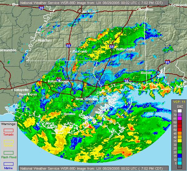
39 Example -- Hurricane Dennis (2005) 105 kt intensity at landfall in the Florida panhandle as determined by recon aircraft


40 Only 80kt Doppler velocities indicated! Why? Maximum actual wind speed not along the direction of the radar viewing angle! STORM MOTION

41 Hurricane Katrina (2005) making landfall near Broward & Miami-Dade County line and later moved over the NHC
42 Hurricane Katrina radar observations from NHC 25 AUG ,AUG,25,1700,26.18,79.51,F,CLOSED CIRCULATION WITH DRY SLOT TO N AND W.,RM,KAMX 2005,AUG,25,1728,26.19,79.50,F,MAX WND 65 KT S QUAD AT 4730 FT,RM,KAMX 2005,AUG,25,1801,26.16,79.54,F,MAX WND 77 KT S QUAD AT 5075 FT,RM,KAMX 2005,AUG,25,1829,26.16,79.63,F,WEAK REF NW SEMICIRCLE...MAX WND 75 KT SE QUAD,RM,KAMX 2005,AUG,25,1902,26.14,79.67,F,80 KTS S OF CTR AT 3900 FT,RM,KAMX 2005,AUG,25,1929,26.14,79.74,F,85 KT MAX S QUAD AT 3417 FT JUST S OF CTR,RM,KAMX 2005,AUG,25,2002,26.07,79.84,F,CENTER RAGGED CMA GOOD ZERO ISODOP,CJM,KAMX 2005,AUG,25,2030,26.00,79.90,G,INBOUND MAX OVER SE BROWARD 75 KT 2300',CJM,KAMX 2005,AUG,25,2058,25.98,79.95,G,STRONGEST CONV S EYEWALL KEY BISCAYNE AREA,CJM,KAMX 2005,AUG,25,2134,25.99,79.96,G,CENTRAL CONV BECOMING MORE SYMMETRICAL,CJM,KAMX 2005,AUG,25,2204,25.97,80.03,G,- -,CJM,KAMX 2005,AUG,25,2231,25.96,80.10,G, CENTER OVER COAST BROWARD-DADE COUNTY LINE,CJM,KAMX 2005,AUG,25,2304,25.96,80.16,G,HIGHEST WINDS OFFSHORE ABOUT 70 KT 1500',CJM,KAMX 2005,AUG,25,2332,25.89,80.24,G,- -,CJM,KAMX 2005,AUG,26,0000,25.88,80.31,G,- -,CJM,KAMX 2005,AUG,26,0034,25.78,80.39,G,NHC IN EYE - CALM OUTSIDE,CJM,KAMX 2005,AUG,26,0101,25.73,80.46,G,75 KT INBOUND OVER CENTRAL DADE 700 FT,CJM,KAMX 2005,AUG,26,0126,25.70,80.53,G,- -,CJM, KAMX 2005,AUG,26,0201,25.64,80.60,G,TIGHT VELOCITY COUPLET STILL EVIDENT IN VEL,CJM,KAMX 2005,AUG,26,0228,25.61,80.71,G,- -,CJM,KAMX 2005,AUG,26,0301,25.58,80.82,G,80 KT AT 900 FT OUTBOUND,CJM,KAMX 2005,AUG,26,0326,25.56,80.93,G,74 KT AT 1600 FT,HDC,KAMX
43 Example -- Hurricane Katrina (2005) Landfall along the southeast Louisiana coast

44
45

46 Maximum velocity Range is -123 kt to +123 kt due to not changing velocity increment to expand detectable velocity range to +248 kt EYE
47 EYE But 90% of 128 kt = 115 kt or Cat 4! 90% of 123 kt = 111 kt or Cat 3 > Kft Only a 5-kt difference in peak average Doppler velocity value would have resulted in a Cat 4 instead of a Cat 3 hurricane at landfall!
48 Example -- Hurricane Humberto (2007) Landfall along the upper Texas coast System strengthened from a 25-kt TD to an 80-kt Hurricane in 24 hours prior to landfall

49 Houston-Galveston, TX radar loop, Sep 2007
50
51 Example -- Tropical Storm Erika (Aug 2015): Heavy Rainfall Event Cyclone passed through the northern Leeward Islands on 27 August 2015 with only kt winds. Produced inches (320 mm) of rainfall in ~12 hours ( UTC) measured at Canefield Airport (TDCF) on southwestern coast of Dominica. Caused flash flooding and mudslides on Dominica, damaged or destroyed 271 houses, and caused major damage to roads, bridges and other infrastructure. Damage estimated to be to US$500 million on Dominica. 30 people killed and 574 persons left homeless.

52 Dominica * 45 kt

53 Canefield Arpt *

54 UW-CIMSS hpa Vertical Wind Shear Deep convection displaced to the southeast of Erika s center due to west-northwesterly deep-layer shear 150, 200, 250, and 300 hpa upper layer-average 700, 775, 850, and 925 hpa lower layer-average

55 UW-CIMSS hpa Mid-Level Wind Shear Deep convection displaced to the southeast of Erika s center due to northwesterly mid-level shear 400, 500, and 600 hpa middle layer-average 700, 775, 850, and 925 hpa lower layer-average
56 nearly symmetrical convergence field SHEAR VECTOR Typical symmetrical TC Low shear Shear vector in same direction as TC motion Balanced low-level convergence field SHEAR VECTOR STORM MOTION preferred regions of low-level convergence Sheared TC Moderate to strong shear Shear vector in opposite direction as TC motion Causes asymmetry of surface pressure/wind fields Creates unbalanced lowlevel convergence field
57 Cause of the heavy rainfall on Dominica Localized storm-scale forcing caused by development of low-level convergence zone over/near island. Localized mesoscale forcing caused by development of leeside vortex west of and over island. Persistent orographic lifting of very moist and unstable air mass caused by low-level westerly winds on south side of TS Erika. Strong west-northwesterly mb vertical wind shear of kt (SHIPS model) displaced convective mass toward the south and east side of Erika s circulation.
58 Example Severe Tropical Cyclone Winston (20 Feb 2016) Landfall along the northern coast of Fiji with estimated 1-minute sustained winds of kt (240 km/h 278 km/h)

59
60 Next: Dual-Polarization Doppler Weather Radars
61 Conventional Horizontal-Polarized Radar Typical rain drop is a flat, oblate spheroid with a wider horizontal axis that returns more energy in the horizontal plane
62 Dual-Polarized Radar Provides betters Z-R relationship and rainfall estimates by determining precipitation type
63 New parameter called Differential Reflectivity or Z DR helps to determine precipitation type Z h = horizontal polarized reflectivity Z v = vertical polarized reflectivity Z h > Z v for raindrops Z h < Z v for large wet hailstones dbz dr = 10 x log (Z h / Z v )
64 Z DR values for meteorological echoes typically range between -2 db and 6 db Values of Z DR well above zero indicate the hydrometeors in the volume are horizontally oriented (e.g., rain) -- meaning their horizontal axis is longer than their vertical axis (P h > P v ). Values of Z DR well below zero indicate the hydrometeors in the volume are vertically oriented (e.g., large hail) -- meaning their vertical axis is longer than their horizontal axis (P h < P v ). Values of Z DR near zero indicate the hydrometeors in the volume have a nearly spherical shape (e.g., snow, giant hail), in the mean (P h ~ P v ).
65 Example: Consider a field of large, falling raindrops. The drops tend to fall with an oblate, horizontal orientation. The field of drops, as a whole, will have a larger cross-section of water in the horizontal plane compared to the vertical. A horizontally-polarized radar pulse will, therefore, backscatter more energy/power in this field of drops than a vertically-polarized pulse will, resulting in more radar return for the horizontal pulse than the vertical pulse. In this case, Power h > Power v => Z h > Z v, so Z DR > 0.
66 Large Raindrops Z v Z h Example: Z h = 317,000 and Z v = 100,000 (i.e. 55 dbz) (i.e. 50 dbz) Therefore, Z DR = 10 log (Z h /Z v ) = 10 log (317000/100000) = 10 log (3.17) = 10 X Z DR = 5.01
67 Large Wet Hailstones Z v Z h Example: Z h = 100,000 and Z v = 317,000 (i.e. 50 dbz) (i.e. 55 dbz) Therefore, Z DR = 10 log (Z h /Z v ) = 10 log (100000/317000) = 10 log (0.315) = 10 X Z DR = -5.01
68 Differential reflectivity values above 2 db are commonly observed in rain. Although hailstones are not necessarily spherical, studies have shown that they fall with a tumbling motion -- meaning a field of falling hailstones within the radar resolution volume will "appear" to consist of nearly spherical hydrometeors. Therefore, the value of dbz DR for hail is usually close to zero. Some graupel and hail hydrometeors with a conical shape can fall with their major axes oriented in the vertical. In these cases, the dbz DR will be found to be negative.

69 Dual-Pol Radar Example -- Hurricane Irene (2011) dbz is same as WSR-88D velocity is same as WSR-88D Z DR denotes areas of intense convection KDP denotes areas of heavy rainfall (light pink) Specific Differential Phase Shift >1.0 Provides betters Z-R relationship and rainfall estimates by determining precipitation type

70 Caribbean Meteorological Organization (CMO) Doppler Weather RADAR Project 13-million (Euro) project that aims to replace old radars with new Doppler radars. Goal: provide improved awareness of approaching tropical cyclones and heavy rainfall events. New radars installed in Barbados, Belize, Guyana, and Trinidad. Barbados
71 Caribbean Meteorological Organization (CMO) Doppler Weather RADAR Project
 <1.")
72 SELEX-Gematronik was awarded the contract for the four METEOR 500S S-Band weather radar systems S-band/10 cm wavelength for maximizing precipitation detection 8.5-meter diameter parabolic antenna dish Not dual-polarization capable (NOTE: 700S model does have dual-polarization capability) <1.0 O beamwidth

73 Barbados Doppler Weather Radar

74 Belize Doppler Weather Radar

75 Trinidad & Tobago Doppler Weather Radar

76 Guyana Doppler Weather Radar
 Doppler velocity is an effective tool in determining tropical cyclone")

77 Conclusions Wavelength is a key design consideration for weather radar (WSR-88D uses 10 cm) Doppler velocity is an effective tool in determining tropical cyclone intensity, and detecting rapid intensification. Future dual polarization will give better precipitation estimates. NEXRAD-in-space will generate radar data for the entire Atlantic basin.
Meteorology 311. RADAR Fall 2016
 Meteorology 311 RADAR Fall 2016 What is it? RADAR RAdio Detection And Ranging Transmits electromagnetic pulses toward target. Tranmission rate is around 100 s pulses per second (318-1304 Hz). Short silent
P4.10. Kenichi Kusunoki 1 * and Wataru Mashiko 1 1. Meteorological Research Institute, Japan
 P4. DOPPLER RADAR INVESTIGATIONS OF THE INNER CORE OF TYPHOON SONGDA (24) Polygonal / elliptical eyewalls, eye contraction, and small-scale spiral bands. Kenichi Kusunoki * and Wataru Mashiko Meteorological
Chapter 2: Polarimetric Radar
 Chapter 2: Polarimetric Radar 2.1 Polarimetric radar vs. conventional radar Conventional weather radars transmit and receive linear electromagnetic radiation whose electric field is parallel to the local
Lessons Learned from Hurricane Harvey and Irma
 EOL Visit to NSF 3 March 2016 Lessons Learned from Hurricane Harvey and Irma Wen-Chau Lee National Center for Atmospheric Research 23 November 2017 Outline: Meteorological elements of the active 2017 Atlantic
(Preliminary) Observations of Tropical Storm Fay Dustin W Phillips Kevin Knupp, & Tim Coleman. 34th Conference on Radar Meteorology October 8, 2009
 Observations of Tropical Storm Fay Dustin W Phillips Kevin Knupp, & Tim Coleman. 34th Conference on Radar Meteorology October 8, 2009") (Preliminary) Observations of Tropical Storm Fay Dustin W Phillips Kevin Knupp, & Tim Coleman 34th Conference on Radar Meteorology October 8, 2009 Outline I. Research Equipment MIPS, MAX, KJAX (WSR-88D)
(Preliminary) Observations of Tropical Storm Fay Dustin W Phillips Kevin Knupp, & Tim Coleman 34th Conference on Radar Meteorology October 8, 2009 Outline I. Research Equipment MIPS, MAX, KJAX (WSR-88D)
Inner core dynamics: Eyewall Replacement and hot towers
 Inner core dynamics: Eyewall Replacement and hot towers FIU Undergraduate Hurricane Internship Lecture 4 8/13/2012 Why inner core dynamics is important? Current TC intensity and structure forecasts contain
LECTURE #15: Thunderstorms & Lightning Hazards
 GEOL 0820 Ramsey Natural Disasters Spring, 2018 LECTURE #15: Thunderstorms & Lightning Hazards Date: 1 March 2018 (lecturer: Dr. Shawn Wright) I. Severe Weather Hazards focus for next few weeks o somewhat
HAZARDOUS WEATHER 1. Dr. Julie Laity Geography 266
 HAZARDOUS WEATHER 1 Dr. Julie Laity Geography 266 Violent Weather Thunderstorms Atmospheric turbulence Lightning and thunder Hail Derechos Tornadoes Tornado measurement and science Tropical Cyclones Hurricanes
4/18/2010. National Weather Service. Severe Weather Forecasting: A Western North Carolina Case Study
 National Weather Service Severe Weather Forecasting: A Western North Carolina Case Study Laurence G. Lee Science and Operations Officer National Weather Service Greer, SC Plus 13 River Forecast Centers
ovember 2008 Antigua and Barbuda Meteorological Service
 ovember 2008 Antigua and Barbuda Meteorological Service The Atlantic Hurricane Season Summary 2008 Special Focus on Antigua and Barbuda The Season in Brief Sixteen (16) named storms formed in the Atlantic
Remote Sensing in Meteorology: Satellites and Radar. AT 351 Lab 10 April 2, Remote Sensing
 Remote Sensing in Meteorology: Satellites and Radar AT 351 Lab 10 April 2, 2008 Remote Sensing Remote sensing is gathering information about something without being in physical contact with it typically
Lecture #18 (April 12, 2010, Monday) Tropical Storms & Hurricanes Part 3. Hurricane Floyd September 15, 1999
 Tropical Storms & Hurricanes Part 3. Hurricane Floyd September 15, 1999") Lecture #18 (April 12, 2010, Monday) Tropical Storms & Hurricanes Part 3 Hurricane Floyd September 15, 1999 Tropical Cyclone Names Names are given to distinguish storms and for ease of communication. Names
Lecture #18 (April 12, 2010, Monday) Tropical Storms & Hurricanes Part 3 Hurricane Floyd September 15, 1999 Tropical Cyclone Names Names are given to distinguish storms and for ease of communication. Names
Tuesday, September 13, 16
 Weather Weather State Objectives 4.c, 4.d, 4.h. Discussion What are some ways in which weather affects your everyday life? Discussion What are some ways in which weather affects your everyday life? What
Hurricane Structure: Theory and Diagnosis
 Hurricane Structure: Theory and Diagnosis 7 March, 2016 World Meteorological Organization Workshop Chris Landsea Chris.Landsea@noaa.gov National Hurricane Center, Miami Outline Structure of Hurricanes
Fundamentals of Radar Display. Atmospheric Instrumentation
 Fundamentals of Radar Display Outline Fundamentals of Radar Display Scanning Strategies Basic Geometric Varieties WSR-88D Volume Coverage Patterns Classic Radar Displays and Signatures Precipitation Non-weather
Tropical Cyclone Isaac (AL092012)
") Tropical Cyclone Isaac (AL092012) Event Briefing, Central Caribbean Impacts Caribbean Risk Managers Ltd Facility Supervisor 27 August 2012 Facility Supervisor: Caribbean Risk Managers Ltd Email: ccrif@ccrif.org
Tropical Cyclone Isaac (AL092012) Event Briefing, Central Caribbean Impacts Caribbean Risk Managers Ltd Facility Supervisor 27 August 2012 Facility Supervisor: Caribbean Risk Managers Ltd Email: ccrif@ccrif.org
THE DETECTABILITY OF TORNADIC SIGNATURES WITH DOPPLER RADAR: A RADAR EMULATOR STUDY
 P15R.1 THE DETECTABILITY OF TORNADIC SIGNATURES WITH DOPPLER RADAR: A RADAR EMULATOR STUDY Ryan M. May *, Michael I. Biggerstaff and Ming Xue University of Oklahoma, Norman, Oklahoma 1. INTRODUCTION The
Marshall Alexander Forecaster Commonwealth of Dominica
 Marshall Alexander Forecaster Commonwealth of Dominica Dominica 2015 Impacts Tropical Storm Danny (August 24 th ) Tropical Storm Erika (August 27 th ) Tropical Storm Grace (Remnants) (September 10 th -11
Tropical Update. 5 PM EDT Thursday, September 7, 2017 Hurricane Irma, Hurricane Jose, and Hurricane Katia
 Tropical Update 5 PM EDT Thursday, September 7, 2017 Hurricane Irma, Hurricane Jose, and Hurricane Katia This update is intended for government and emergency response officials, and is provided for informational
ANALYSIS AND DETECTION OF TORNADOES ASSOCIATED WITH HURRICANE EMILY
 ANALYSIS AND DETECTION OF TORNADOES ASSOCIATED WITH HURRICANE EMILY Kurt M. Van Speybroeck*, M. Martin, Jr., A. Patrick and J. Haro National Weather Service Brownsville, TX 1. INTRODUCTION Hurricane Emily
ARUBA CLIMATOLOGICAL SUMMARY 2017 PRECIPITATION
 ARUBA CLIMATOLOGICAL SUMMARY 2017 PRECIPITATION The total amount of rainfall recorded at Reina Beatrix International Airport for the year 2017 was 391.0 mm. This is 17.1 % below normal ( Figure 1 ). During
Ch. 11: Hurricanes. Be able to. Define what hurricane is. Identify the life and death of a hurricane. Identify the ways we track hurricanes.
 Ch. 11: Hurricanes Be able to Define what hurricane is. Identify the life and death of a hurricane. Identify the ways we track hurricanes. What are Hurricanes? Smaller than mid-latitude cyclones. Don t
Hurricane Harvey the Name says it all. by Richard H. Grumm and Charles Ross National Weather Service office State College, PA
 Hurricane Harvey the Name says it all by Richard H. Grumm and Charles Ross National Weather Service office State College, PA 16803. 1. Overview Hurricane Harvey crossed the Texas coast (Fig. 1) as a category
Utilization of Dual-pol data
 WMO/ASEAN Training Workshop on Weather Radar Data Quality and Standardization Utilization of Dual-pol data 8 February 2018 Hiroshi Yamauchi Observation Department Japan Meteorological Agency Japan Meteorological
Chapter 24 Tropical Cyclones
 Chapter 24 Tropical Cyclones Tropical Weather Systems Tropical disturbance a cluster of thunderstorms about 250 to 600 km in diameter, originating in the tropics or sub-tropics Tropical depression a cluster
Tropical Waves. John Cangialosi and Lixion Avila National Hurricane Center. WMO Region IV Tropical Cyclone Workshop
 Tropical Waves John Cangialosi and Lixion Avila National Hurricane Center WMO Region IV Tropical Cyclone Workshop Outline Basic definition Schematic diagrams/interactions Operational products/forecasts
ATS 351, Spring 2010 Lab #9 Weather Radar - 55 points
 ATS 351, Spring 2010 Lab #9 Weather Radar - 55 points 1. (5 points) If a radar has a maximum unambiguous range of 300km, what is its PRF? (The speed of light, c, is equal to 3x10 8 m/s) The equation to
Hurricane Science Tutorial. Kerry Emanuel Lorenz Center, MIT
 Hurricane Science Tutorial Kerry Emanuel Lorenz Center, MIT Why Should You Care? Forecasting Much progress in social science of response to warnings, requests to evacuate, etc. Forecasters are ambassadors
Tropical Cyclone Forecasting Applications of the GOES WMSI
 1. Introduction Tropical Cyclone Forecasting Applications of the GOES WMSI Kenneth L. Pryor Center for Satellite Applications and Research (NOAA/NESDIS) Camp Springs, MD The Geostationary Operational Environmental
Ocean in Motion 7: El Nino and Hurricanes!
 Ocean in Motion 7: El Nino and Hurricanes! A. Overview 1. Ocean in Motion -- El Nino and hurricanes We will look at the ocean-atmosphere interactions that cause El Nino and hurricanes. Using vocabulary
Mid-Atlantic Severe Weather Event of 23 June 2015
 Mid-Atlantic Severe Weather Event of 23 June 2015 By Richard H. Grumm National Weather Service State College, PA 1. Overview A widespread severe weather event occurred in the eastern United States on 23
Typhoon Maemi and Hurricane Katrina: Impacts and Aftermath. Typhoon Maemi: September 13, Typhoon Maemi Track and Characteristics
 Typhoon Maemi and Hurricane Katrina: Impacts and Aftermath Pierre Julien Un Ji Department of Civil Engineering Colorado State University Fort Collins, Colorado USA September, 2005 Typhoon Maemi: September
Double (Concentric) Eyewalls in Hurricane Katrina at Landfall:
 Eyewalls in Hurricane Katrina at Landfall:") Double (Concentric) Eyewalls in Hurricane Katrina at Landfall: A Key to the Storm s Huge Size and Devastating Impact over a Three-State Coastal Region Keith Blackwell Coastal Weather Research Center University
Double (Concentric) Eyewalls in Hurricane Katrina at Landfall: A Key to the Storm s Huge Size and Devastating Impact over a Three-State Coastal Region Keith Blackwell Coastal Weather Research Center University
Comparison of polarimetric radar signatures in hailstorms simultaneously observed by C-band and S-band radars.
 Comparison of polarimetric radar signatures in hailstorms simultaneously observed by C-band and S-band radars. R. Kaltenboeck 1 and A. Ryzhkov 2 1 Austrocontrol - Aviation Weather Service, Vienna and Institute
Flooding and Severe weather of 27 June 2013
 Flooding and Severe weather of 27 June 2013 By Richard H. Grumm National Weather Service State College, PA 1. Overview Flooding and severe weather affected Pennsylvania on 27 June 2013 (Fig 1). The severe
Convective Structures in Clear-Air Echoes seen by a Weather Radar
 Convective Structures in Clear-Air Echoes seen by a Weather Radar Martin Hagen Deutsches Zentrum für Luft- und Raumfahrt Oberpfaffenhofen, Germany Weather Radar Weather radar are normally used to locate
Tropical Cyclones. Objectives
 Tropical Cyclones FIU Undergraduate Hurricane Internship Lecture 2 8/8/2012 Objectives From this lecture you should understand: Global tracks of TCs and the seasons when they are most common General circulation
Chapter 24. Tropical Cyclones. Tropical Cyclone Classification 4/19/17
 Chapter 24 Tropical Cyclones Tropical Cyclones Most destructive storms on the planet Originate over tropical waters, but their paths often take them over land and into midlatitudes Names Hurricane (Atlantic
WEDNESDAY 30 TH AUGUST, :57 p.m. Tropical Storm Irma forms in the Atlantic. Don t let your guard down, always #Be Ready.
 Chapter 1 - The Set Up In the days leading up to Irma a series of composed and sobering text messages, presented in truncated form below, from Department of Disaster Management warned us of the pending
LECTURE #18: Hurricane Damage, Monitoring & Case Study
 GEOL 0820 Ramsey Natural Disasters Spring, 2018 LECTURE #18: Hurricane Damage, Monitoring & Case Study Date: 27 March 2018 I. Exam II grades now posted online o high: 98, low: 46, average: 80 (~3 points
Impact of the 2008 tropical cyclone season on the Baja California Peninsula
 Impact of the 2008 tropical cyclone season on the Baja California Peninsula Centro de Investigación Científica y de Educación Superior de Ensenada (CICESE) Luis M. Farfán Julio August 24, 1830UTC Lowell
Hurricanes and Tropical Weather Systems:
 Hurricanes and Tropical Weather Systems: An influence on weather in parts of the USA Meteorology 411 Iowa State University Week 2 Bill Gallus Classification/Terminology Tropical Disturbance enhanced convection
Tropical Rainfall Rate Relations Assessments from Dual Polarized X-band Weather Radars
 Tropical Rainfall Rate Relations Assessments from Dual Polarized X-band Weather Radars Carlos R. Wah González, José G. Colom Ustáriz, Leyda V. León Colón Department of Electrical and Computer Engineering
Section 13-1: Thunderstorms
 Section 13-1: Thunderstorms Chapter 13 Main Idea: The intensity and duration of thunderstorms depend on the local conditions that create them. Air-mass thunderstorm Mountain thunderstorm Sea-breeze thunderstorm
Severe storms over the Mediterranean Sea: A satellite and model analysis
 National Research Council of Italy Severe storms over the Mediterranean Sea: A satellite and model analysis V. Levizzani, S. Laviola, A. Malvaldi, M. M. Miglietta, and E. Cattani 6 th International Precipitation
UNIVERSITY OF OKLAHOMA GRADUATE COLLEGE POLARIMETRIC RADAR SIGNATURES IN DAMAGING DOWNBURST PRODUCING THUNDERSTORMS. A thesis
 UNIVERSITY OF OKLAHOMA GRADUATE COLLEGE POLARIMETRIC RADAR SIGNATURES IN DAMAGING DOWNBURST PRODUCING THUNDERSTORMS A thesis SUBMITTED TO THE GRADUATE FACULTY in partial fulfillment of the requirements
Storm Summary for Hurricane Joaquin
 Storm Summary for Hurricane Joaquin Wednesday, September 30, 2015 at 5 PM EDT (Output from Hurrevac, based on National Hurricane Center Forecast Advisory #12) Joaquin is currently a Category 1 hurricane
Introduction. Suita. Kobe. Okinawa. Tsukuba. Tokyo? in in in in 2017 See Poster #16 2. in 2015
 1 Introduction We developed the X band Phased Array Weather Radar (PAWR) to watch and predict severe weather disasters caused by localized heavy rainfalls or tornadoes. The PAWR measures 3 dimentional
Lecture 15: Doppler Dilemma, Range and Velocity Folding, and Interpreting Doppler velocity patterns
 MET 4410 Remote Sensing: Radar and Satellite Meteorology MET 5412 Remote Sensing in Meteorology Lecture 15: Doppler Dilemma, Range and Velocity Folding, and Interpreting Doppler velocity patterns Doppler
Dual-pol Radar Measurements of Hurricane Irma and Comparison of Radar QPE to Rain Gauge Data
 Dual-pol Radar Measurements of Hurricane Irma and Comparison of Radar QPE to Rain Gauge Data Qing Cao and Michael Knight Enterprise Electronic Corporation (EEC) Enterprise, Alabama, USA Email: qingcao@eecweathertech.com
Florida Tropical Cyclone Rainfall Totals as Related to Storm Location and Intensity
 Florida Tropical Cyclone Rainfall Totals Matyas Florida Tropical Cyclone Rainfall Totals as Related to Storm Location and Intensity Corene Matyas Assistant Professor Department of Geography University
SAMPLE. SITE SPECIFIC WEATHER ANALYSIS Wind Report. Robinson, Smith & Walsh. John Smith. July 1, 2017 REFERENCE: 1 Maple Street, Houston, TX 77034
 SAMPLE SITE SPECIFIC WEATHER ANALYSIS Wind Report PREPARED FOR: Robinson, Smith & Walsh John Smith July 1, 2017 REFERENCE: JACK HIGGINS / 4151559-01 1 Maple Street, Houston, TX 77034 CompuWeather Sample
Indiana County Flash Flood of 22 June 2017
 Indiana County Flash Flood of 22 June 2017 By Richard H. Grumm National Weather Service State College, PA 1. Overview Slow moving thunderstorms brought 3 to 4 inches of rainfall to Indiana County, PA during
Thunderstorm Downburst Prediction: An Integrated Remote Sensing Approach. Ken Pryor Center for Satellite Applications and Research (NOAA/NESDIS)
") Thunderstorm Downburst Prediction: An Integrated Remote Sensing Approach Ken Pryor Center for Satellite Applications and Research (NOAA/NESDIS) Topics of Discussion Thunderstorm Life Cycle Thunderstorm
Thunderstorm Downburst Prediction: An Integrated Remote Sensing Approach Ken Pryor Center for Satellite Applications and Research (NOAA/NESDIS) Topics of Discussion Thunderstorm Life Cycle Thunderstorm
Thunderstorm Forecasting and Warnings in the US: Applications to the Veneto Region
 Thunderstorm Forecasting and Warnings in the US: Applications to the Veneto Region Bill Conway Vice President Weather Decision Technologies Norman, Oklahoma, USA Andrea Rossa ARPAV Lead Scientist Centre
Tropical Update. 5 PM EDT Thursday, August 27, 2015 Tropical Storm Erika
 Tropical Update 5 PM EDT Thursday, August 27, 2015 Tropical Storm Erika This update is intended for government and emergency response officials, and is provided for informational and situational awareness
P1.6 Simulation of the impact of new aircraft and satellite-based ocean surface wind measurements on H*Wind analyses
 P1.6 Simulation of the impact of new aircraft and satellite-based ocean surface wind measurements on H*Wind analyses Timothy L. Miller 1, R. Atlas 2, P. G. Black 3, J. L. Case 4, S. S. Chen 5, R. E. Hood
USING GIS TO ASSESS THE SYMMETRY OF TROPICAL CYCLONE RAIN SHIELDS. Corene J. Matyas University of Florida PO Box , Gainesville, FL 32611
 Papers of the Applied Geography Conferences (2006) 29: 31-39 USING GIS TO ASSESS THE SYMMETRY OF TROPICAL CYCLONE RAIN SHIELDS Corene J. Matyas University of Florida PO Box 117315, Gainesville, FL 32611
Observational analysis of storms and flooding events in the Pacific Northwest. Introduction
 Observational analysis of storms and flooding events in the Pacific Northwest Jake Crouch UNCA ATMS Class of 2007 April 18, 2009 Cloud and Precipitation Processes and Patterns Group Introduction Average
Hurricanes. Hurricanes are large, tropical storm systems that form and develop over the warm waters near the equator.
 Hurricanes Hurricanes are large, tropical storm systems that form and develop over the warm waters near the equator. They are responsible for weather that can devastate entire communities: Heavy rain --
LECTURE #17: Severe Weather: Introduction to Hurricanes
 GEOL 0820 Ramsey Natural Disasters Spring, 2018 LECTURE #17: Severe Weather: Introduction to Hurricanes Date: 15 March 2018 I. Hurricane Overview hurricanes o what they are? o how they form? storm stages:
Storm Summary for Hurricane Jose
 Storm Summary for Hurricane Jose Tuesday, September 19, 2017 at 11 AM EDT (Output from Hurrevac, based on National Hurricane Center Forecast Advisory #57) Jose is currently a Category 1 hurricane on the
Vertically Integrated Ice A New Lightning Nowcasting Tool. Matt Mosier. NOAA/NWS Fort Worth, TX
 P686 Vertically Integrated Ice A New Lightning Nowcasting Tool Matt Mosier NOAA/NWS Fort Worth, TX 1. BACKGROUND AND METHODOLOGY Lightning is a frequent and dangerous phenomenon, especially in the summer
Covered Area Rainfall Event (18-20 October 2017) Excess Rainfall
 Excess Rainfall") Covered Area Rainfall Event (18-20 October 2017) Excess Rainfall Event Briefing Trinidad 29 October 2017 Registered Office: CCRIF SPC c/o Sagicor Insurance Managers Ltd., 198 North Church Street 2nd Floor
Covered Area Rainfall Event (18-20 October 2017) Excess Rainfall Event Briefing Trinidad 29 October 2017 Registered Office: CCRIF SPC c/o Sagicor Insurance Managers Ltd., 198 North Church Street 2nd Floor
MET Lecture 34 Downbursts
 MET 4300 Lecture 34 Downbursts Downbursts A strong downdraft that originates within the lower part of a cumulus cloud or thunderstorms and spreads out at the surface Downbursts do not require strong thunderstorms
DEPARTMENT OF EARTH & CLIMATE SCIENCES SAN FRANCISCO STATE UNIVERSITY. Metr Fall 2014 Test #1 September 30, 2014
 DEPARTMENT OF EARTH & CLIMATE SCIENCES SAN FRANCISCO STATE UNIVERSITY NAME Metr 302.02 Fall 2014 Test #1 September 30, 2014 200 pts (4 pts each answer) Part I. Surface Chart Interpretation. Questions 1
HURRICANE JEANNE CHARACTERISTICS and STORM TIDE EVALUATION
 HURRICANE JEANNE CHARACTERISTICS and STORM TIDE EVALUATION ((DRAFT)) By Robert Wang and Michael Manausa Sponsored by Florida Department of Environmental Protection, Bureau of Beaches and Coastal Systems
Characterizing the Structure of Hurricane Karl (2010): Doppler Radar and WRF
: Doppler Radar and WRF") Characterizing the Structure of Hurricane Karl (2010): Doppler Radar and WRF Jennifer DeHart and Robert Houze Atmospheric Physics and Chemistry Seminar 5.9.16 NASA grants: NNX13AG71G / NNX12AJ82G Orographic
Characterizing the Structure of Hurricane Karl (2010): Doppler Radar and WRF Jennifer DeHart and Robert Houze Atmospheric Physics and Chemistry Seminar 5.9.16 NASA grants: NNX13AG71G / NNX12AJ82G Orographic
Tropical Update. 5 AM EDT Thursday, September 7, 2017 Hurricane Irma, Hurricane Jose, and Hurricane Katia
 Tropical Update 5 AM EDT Thursday, September 7, 2017 Hurricane Irma, Hurricane Jose, and Hurricane Katia This update is intended for government and emergency response officials, and is provided for informational
(April 7, 2010, Wednesday) Tropical Storms & Hurricanes Part 2
 Tropical Storms & Hurricanes Part 2") Lecture #17 (April 7, 2010, Wednesday) Tropical Storms & Hurricanes Part 2 Hurricane Katrina August 2005 All tropical cyclone tracks (1945-2006). Hurricane Formation While moving westward, tropical disturbances
Lecture #17 (April 7, 2010, Wednesday) Tropical Storms & Hurricanes Part 2 Hurricane Katrina August 2005 All tropical cyclone tracks (1945-2006). Hurricane Formation While moving westward, tropical disturbances
HURRICANE FRANCES CHARACTERISTICS and STORM TIDE EVALUATION
 HURRICANE FRANCES CHARACTERISTICS and STORM TIDE EVALUATION ((DRAFT)) By Robert Wang and Michael Manausa Sponsored by Florida Department of Environmental Protection, Bureau of Beaches and Coastal Systems
Homework 8: Hurricane Damage (adapted from Pipkin et al.)
") 1 Homework 8: Hurricane Damage (adapted from Pipkin et al.) Tropical cyclones have a significant impact on coastal areas of the world. In the Atlantic and Eastern Pacific Oceans they are called hurricanes
1 Homework 8: Hurricane Damage (adapted from Pipkin et al.) Tropical cyclones have a significant impact on coastal areas of the world. In the Atlantic and Eastern Pacific Oceans they are called hurricanes
RODGER A. BROWN NOAA/National Severe Storms Laboratory, Norman, OK
 Preprints, 25th Intern. Conf. on Interactive Information and Processing Systems, Phoenix, AZ, Amer. Meteor. Soc., January 2009 9B.3 Progress Report on the Evolutionary Characteristics of a Tornadic Supercell
A LOOK AT TROPICAL STORM GASTON FLOODING IN VIRGINIA
 J12B.4 A LOOK AT TROPICAL STORM GASTON FLOODING IN VIRGINIA John Billet* and Keith Lynch NOAA/NWS Wakefield, VA 1. INTRODUCTION Hurricane Gaston made landfall north of Charleston, SC on Sunday morning
Lab 6 Radar Imagery Interpretation
 Lab 6 Radar Imagery Interpretation Background Weather radar (radio detection and ranging) is another very useful remote sensing tool used in meteorological forecasting. Microwave radar was developed in
A Tropical Cyclone with a Very Large Eye
 JANUARY 1999 PICTURES OF THE MONTH 137 A Tropical Cyclone with a Very Large Eye MARK A. LANDER University of Guam, Mangilao, Guam 9 September 1997 and 2 March 1998 1. Introduction The well-defined eye
Test Form: A Key Final Exam: Spring 2011
 Test Form: A Key Final Exam: Spring 2011 Instructions: Write your name (last name and first name) on your bubble sheet. Write your student identification number on the bubble sheet, and carefully and completely
Tropical Update. 11 AM EDT Tuesday, October 9, 2018 Hurricane Michael, Tropical Storm Leslie, Tropical Storm Nadine
 Tropical Update 11 AM EDT Tuesday, October 9, 2018 Hurricane Michael, Tropical Storm Leslie, Tropical Storm Nadine This update is intended for government and emergency response officials, and is provided
ANSWER KEY. Part I: Synoptic Scale Composite Map. Lab 12 Answer Key. Explorations in Meteorology 54
 ANSWER KEY Part I: Synoptic Scale Composite Map 1. Using Figure 2, locate and highlight, with a black dashed line, the 500-mb trough axis. Also, locate and highlight, with a black zigzag line, the 500-mb
The Severe Weather Event of 7 August 2013 By Richard H. Grumm and Bruce Budd National Weather Service State College, PA 1. INTRODUCTION and Overview
 The Severe Weather Event of 7 August 2013 By Richard H. Grumm and Bruce Budd National Weather Service State College, PA 1. INTRODUCTION and Overview A fast moving short-wave (Fig. 1) with -1σ 500 hpa height
Monthly Long Range Weather Commentary Issued: SEPTEMBER 19, 2016 Steven A. Root, CCM, Chief Analytics Officer, Sr. VP,
 Monthly Long Range Weather Commentary Issued: SEPTEMBER 19, 2016 Steven A. Root, CCM, Chief Analytics Officer, Sr. VP, sroot@weatherbank.com SEPTEMBER 2016 Climate Highlights The Month in Review The contiguous
Covered Area Rainfall Event (29-30 September 2016) Tropical Cyclone Matthew Excess Rainfall
 Tropical Cyclone Matthew Excess Rainfall") Covered Area Rainfall Event (29-30 September 2016) Tropical Cyclone Matthew Excess Rainfall Event Briefing Dominica 11 October 2016 Registered Office: c/o Sagicor Insurance Managers Ltd., 103 South Church
Covered Area Rainfall Event (29-30 September 2016) Tropical Cyclone Matthew Excess Rainfall Event Briefing Dominica 11 October 2016 Registered Office: c/o Sagicor Insurance Managers Ltd., 103 South Church
Multiscale Analyses of Inland Tropical Cyclone Midlatitude Jet Interactions: Camille (1969) and Danny (1997)
 and Danny (1997)") Multiscale Analyses of Inland Tropical Cyclone Midlatitude Jet Interactions: Camille (1969) and Danny (1997) Matthew Potter, Lance Bosart, and Daniel Keyser Department of Atmospheric and Environmental
Multiscale Analyses of Inland Tropical Cyclone Midlatitude Jet Interactions: Camille (1969) and Danny (1997) Matthew Potter, Lance Bosart, and Daniel Keyser Department of Atmospheric and Environmental
Observations of hail cores of tornadic thunderstorms with four polarimetric radars
 Observations of hail cores of tornadic thunderstorms with four polarimetric radars Valery Melnikov 1,2, Dusan Zrnic 2, Donald Burgess 1,2, and Edward Mansell 2 1 The University of Oklahoma, CIMMS, Norman,
Foundations of Earth Science, 6e Lutgens, Tarbuck, & Tasa
 Foundations of Earth Science, 6e Lutgens, Tarbuck, & Tasa Weather Patterns and Severe Weather Foundations, 6e - Chapter 14 Stan Hatfield Southwestern Illinois College Air masses Characteristics Large body
Hurricane Wilma Post Storm Data Acquisition Estimated Peak Wind Analysis and Storm Tide Data. December 27, 2005
 Hurricane Wilma Post Storm Data Acquisition Estimated Peak Wind Analysis and Storm Tide Data December 27, 2005 Hurricane Wilma was the sixth major hurricane of the record-breaking 2005 Atlantic hurricane
HURRICANE CHARLEY CHARACTERISTICS and STORM TIDE EVALUATION
 HURRICANE CHARLEY CHARACTERISTICS and STORM TIDE EVALUATION By Robert Wang, Michael Manausa And Jenny Cheng Sponsored by Florida Department of Environmental Protection, Bureau of Beaches and Coastal Systems
Convection and Shear Flow in TC Development and Intensification
 DISTRIBUTION STATEMENT A. Approved for public release; distribution is unlimited. Convection and Shear Flow in TC Development and Intensification C.-P. Chang Department of Meteorology Naval Postgraduate
IMPROVEMENTS OF POLARIMETRIC RADAR ECHO CLASSIFICATIONS. Ronald Hannesen* Selex-Gematronik, Neuss, Germany
 P13.14 IMPROVEMENTS OF POLARIMETRIC RADAR ECHO CLASSIFICATIONS Ronald Hannesen* Selex-Gematronik, Neuss, Germany 1. INTRODUCTION A two-step radar echo classification is applied on polarimetric radar data:
Convection and Shear Flow in TC Development and Intensification
 DISTRIBUTION STATEMENT A. Approved for public release; distribution is unlimited. Convection and Shear Flow in TC Development and Intensification C.-P. Chang Department of Meteorology Naval Postgraduate
Hurricane Structure: Theory and Application. John Cangialosi National Hurricane Center
 Hurricane Structure: Theory and Application John Cangialosi National Hurricane Center World Meteorological Organization Workshop Is this Tropical, Subtropical, or Extratropical? Subtropical Tropical Extratropical
How does NASA study hurricanes? 17 August 2015, by Max Gleber
 How does NASA study hurricanes? 17 August 2015, by Max Gleber Hurricanes are the most powerful weather event on Earth. NASA's expertise in space and scientific exploration contributes to essential services
SAMPLE. SITE SPECIFIC WEATHER ANALYSIS Wind Report. Robinson, Smith & Walsh. John Smith REFERENCE:
 SAMPLE SITE SPECIFIC WEATHER ANALYSIS Wind Report PREPARED FOR: Robinson, Smith & Walsh John Smith REFERENCE: JACK HIGGINS / 4151559-01 CompuWeather Sample Report Please note that this report contains
An upper to mid level circulation (Low) in the NW Caribbean is
 in the NW Caribbean is") WEEKLY WEATHER OUTLOOK BELIZE, CENTRAL AMERICA PERIOD: Monday-Monday, Oct. 1 October 8, 2012 DATE ISSUED: Monday, Oct 1, 2012 6:00 am RFrutos EcoSolutions & Services SYNOPSIS: An upper to mid level circulation
WEEKLY WEATHER OUTLOOK BELIZE, CENTRAL AMERICA PERIOD: Monday-Monday, Oct. 1 October 8, 2012 DATE ISSUED: Monday, Oct 1, 2012 6:00 am RFrutos EcoSolutions & Services SYNOPSIS: An upper to mid level circulation
The Impact of 2007 Atlantic Hurricane Season on Dominica
 The Impact of 2007 Atlantic Hurricane Season on Dominica DOMINICA November 2007 Main Activities Freak Twister on June 21st 2007. Hurricane Dean on August 16th to 17th 2007 Active Tropical Wave on September
GC Briefing. Weather Sentinel Tropical Storm Michael. Status at 8 AM EDT (12 UTC) Today (NHC) Discussion. October 11, 2018
 Today (NHC) Discussion. October 11, 2018") GC Briefing Weather Sentinel Tropical Storm Michael October 11, 2018 After making landfall as a high-end category-4 hurricane on the Florida Panhandle, Michael weakened to tropical storm status early this
GC Briefing Weather Sentinel Tropical Storm Michael October 11, 2018 After making landfall as a high-end category-4 hurricane on the Florida Panhandle, Michael weakened to tropical storm status early this
Ship-Based Measurements of Cloud Microphysics and PBL Properties in Precipitating Trade Cumuli During RICO
 Ship-Based Measurements of Cloud Microphysics and PBL Properties in Precipitating Trade Cumuli During RICO Institutions: University of Miami; University of Colorado; NOAA ETL Investigators: P. Kollias
Homework 2: Hurricane Katrina. Part 1. Hurricane Katrina, August 28, 2005 Satellite Imagery
 Metr 302 Homework 2 Fall 2014 Meteorology 302 Fall 2014 Name Homework 2: Hurricane Katrina 100 points total Distributed Thursday 30 October 2014; Due Thursday 13 November 2014 Answer all questions in complete
WIND PROFILER NETWORK OF JAPAN METEOROLOGICAL AGENCY
 WIND PROFILER NETWORK OF JAPAN METEOROLOGICAL AGENCY Masahito Ishihara Japan Meteorological Agency CIMO Expert Team on Remote Sensing Upper-Air Technology and Techniques 14-17 March, 2005 Geneva, Switzerland
Lectures on Tropical Cyclones
 Lectures on Tropical Cyclones Chapter 1 Observations of Tropical Cyclones Outline of course Introduction, Observed Structure Dynamics of Mature Tropical Cyclones Equations of motion Primary circulation