Mapping Weather Information
|
|
|
- Augusta Priscilla Hawkins
- 6 years ago
- Views:
Transcription


1 Charles Sturt University Wagga Wagga 17 October 2013 Mapping Weather Information Robert Dahni Bureau of Meteorology


2 Bureau of Meteorology The Bureau's mission We provide Australians with environmental intelligence for safety, sustainability, well-being and prosperity. ENVIRONMENTAL INTELLIGENCE Conclusions drawn from environmental observations and models to guide decisions and actions by governments, businesses and individuals. Dr Robert Dahni >30 years with BoM Meteorologist Data IT Officer Analyse Programmer Visualise Georabble GIS


3 20,000 daily average users on site at all times Up to 90,000 during severe events 45% of visitors accessed the website via a mobile device in March 2013 Web Advertising commenced May th most visited website in Australia in January In , 52 million individual users made 48 billion hits on website

, Map Background (application) for creation of")
 using centralised and")
.")
4 Wagga Wagga 7-day Forecast Part of nationally consistent set of web clickable maps. ArcMap (spatial data maintenance), Excel (editing of location data sets), Map Background (application) for creation of images/html (including interactive placement of labels and automatic derivation of hotlinks) using centralised and maintained repository of spatial data, and Fireworks (image overlays). Efficient process for management of static web maps (e.g. clickable maps and radar background/layers).


")
5 Radar Network Part of nationally consistent set of web clickable maps. Map Background (application) Radar Network (shapefile) Fireworks (overlays)

")
6 Mapping Radar Coverage , Google Static Maps API Convention Centre Charles Sturt University Wagga Wagga Radar Coverage Shapefile GIS Programming Mapper (application) "Mercator" Map Projection


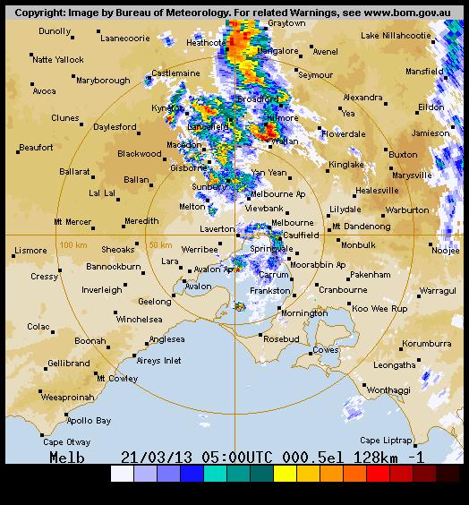
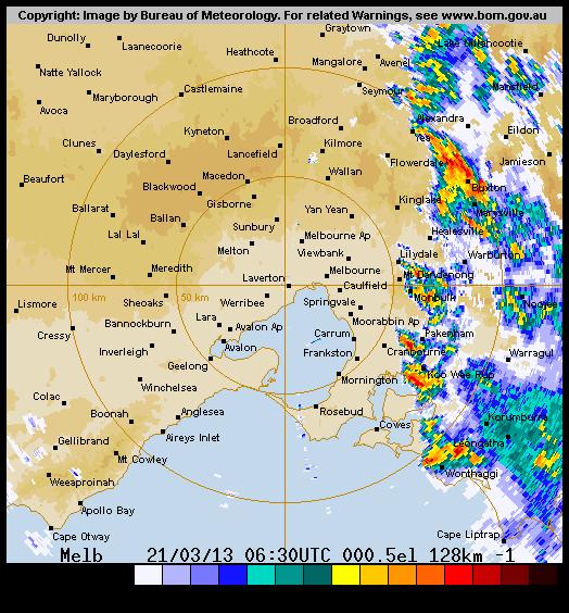
7 Significant Weather Event Synoptic Chart Severe Thunderstorm Warning Cold front crossed Victoria. Widespread damaging winds were experienced. The front also triggered numerous thunderstorms.


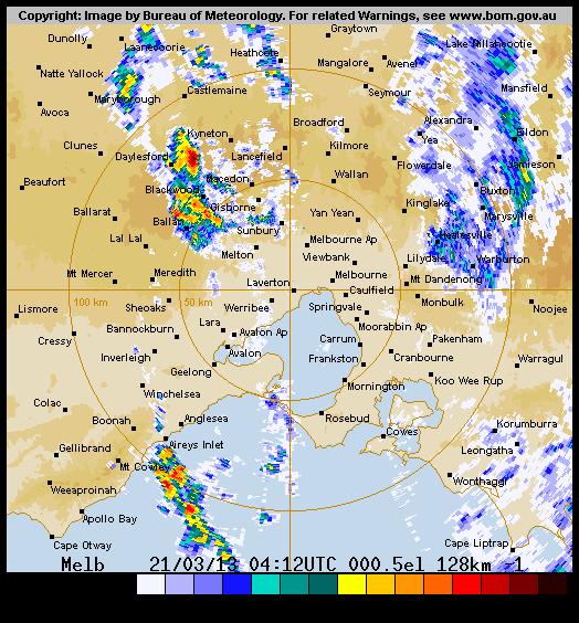
8 Thunderstorms - Melbourne Severe Thunderstorm Forecast Melbourne Radar


9 Supercells - Yarrawonga A number of thunderstorms in northern Victoria developed into supercells. Several tornadoes developed during the afternoon and evening associated with these supercells. An assessment of the damage confirmed there were at least 7 tornadoes. 256km 128km

10 Spatial Radar Data Radar Archive Yarrawonga 0720 UTC 21 March 2013 Radar Data Polar Data Format Programming Polygon Shapefile QGIS 2.0 Radar Symbology Validate Data

 \"Mercator\" Map Projection")

11 Mapping Radar Data Map Centred at Wangaratta No Elevation Background Revised Location Names GIS Programming Mapper (application) "Mercator" Map Projection Tornadoes Observed Yarrawonga Radar Image Google BOM Radar Map Background (radar image transparency)


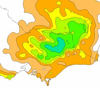
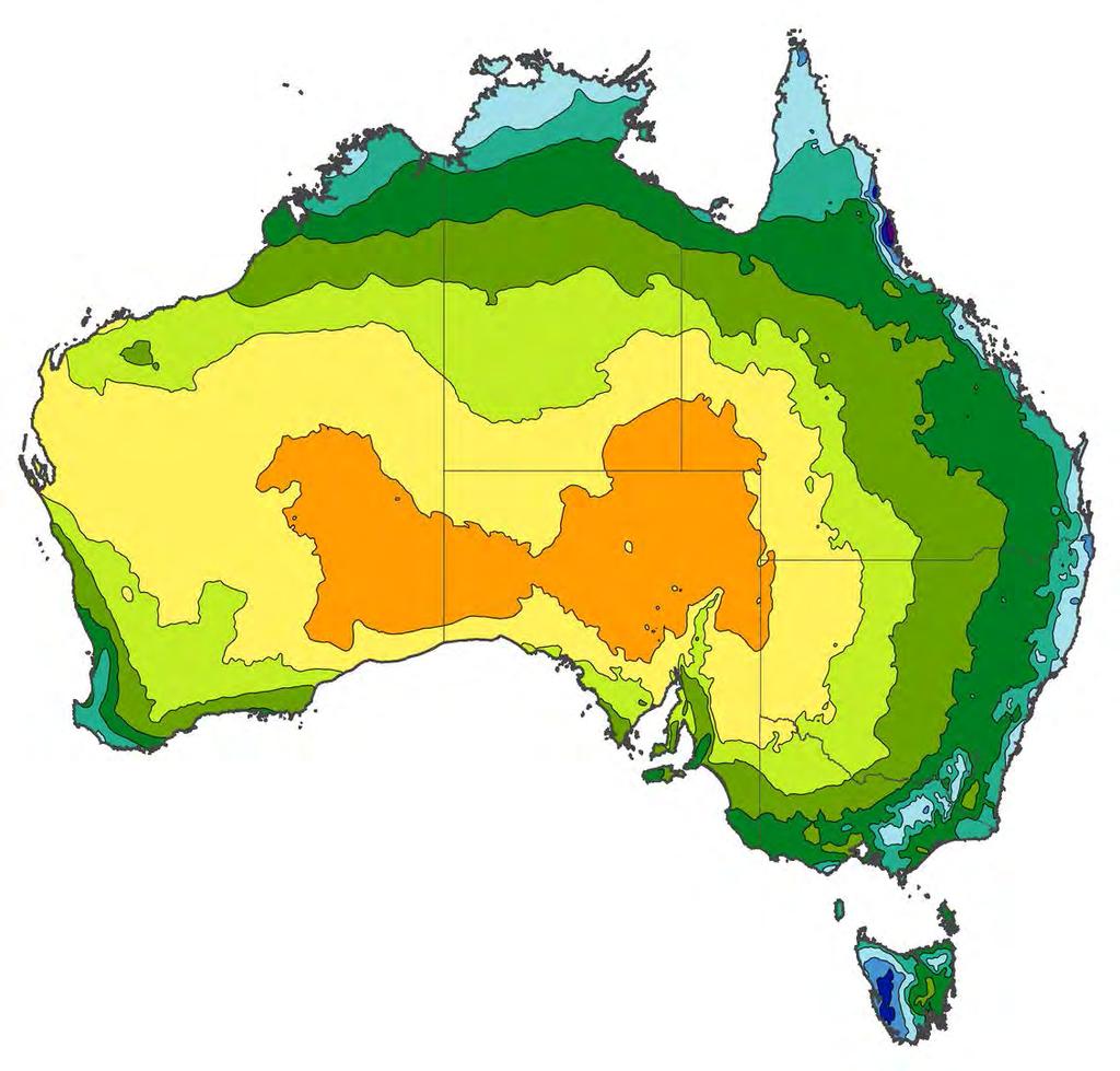
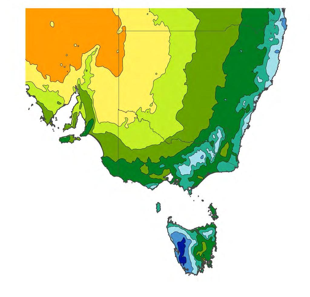
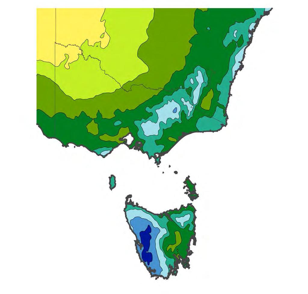
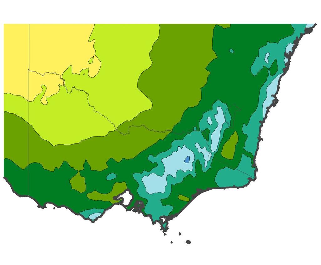
12 Climate Maps - Recent Conditions


13 Climate Maps - Average Conditions

14 AWAP Data "GIS" Programming Climate Averages Colour Scale (NZ Climate Maps) Mapping Climate Data


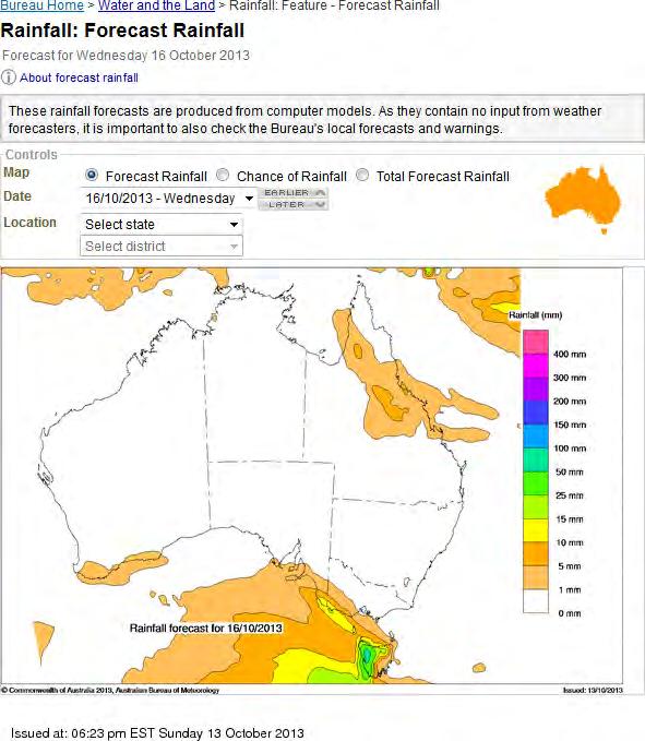
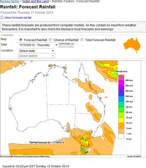
15 Rainfall Forecast - Outlook


16 MetEye What is MetEye TM? MetEye TM is an online mapping tool or Geographic Information System (GIS), used to visualise weather data for Australia. Front-end OpenLayers ExtJS GeoExt jquery Back-end MapServer MapCache PostGIS


17 MetEye - Wagga Wagga

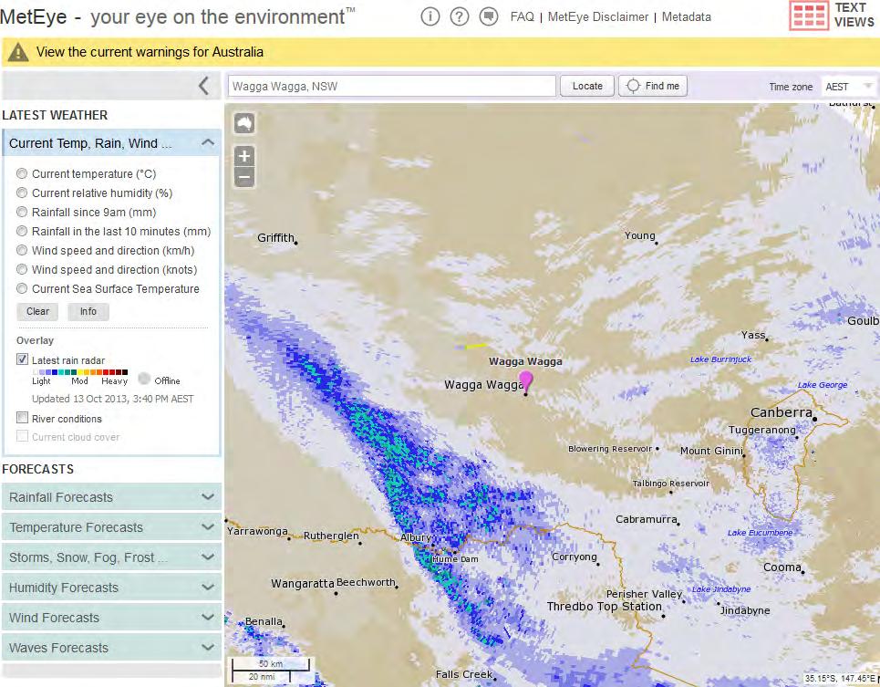
18 MetEye - Radar


19 Radar Viewer Geo-referencing Gnomonic Projection Lat/Lon Corner Points Australia-wide Mosaic 6-10 min Updates Overlapping Radars Radar Outages High-Resolution Do-It-Yourself Radar Images Polar Radar Data Volumetric Data

 \"Mercator\" Map Projection Hail")

20 Hail Storm Hits Malua Bay Map Centred at Batemans Bay No Elevation Background Revised Location Names GIS Programming Mapper (application) "Mercator" Map Projection Hail Storm Observed Canberra Radar Image 0706 UTC 14 October 2013 Google BOM Radar Map Background (radar image transparency)


21 Thank you Rain? Pocket Weather Rain Brain Don't Get Wet Robert Dahni (03) Robert Dahni
QPE and QPF in the Bureau of Meteorology
 QPE and QPF in the Bureau of Meteorology Current and future real-time rainfall products Carlos Velasco (BoM) Alan Seed (BoM) and Luigi Renzullo (CSIRO) OzEWEX 2016, 14-15 December 2016, Canberra Why do
Counselor s Name: Counselor s Ph #: 1) Define meteorology. Explain how the weather affects farmers, sailors, aviators,
 Define meteorology. Explain how the weather affects farmers, sailors, aviators,") Weather Merit Badge Workbook This workbook is not required but is designed to help you with this merit badge. No one can add or subtract from the Boy Scout Requirements #33215. Use page backs & add pages
Weather Merit Badge Workbook This workbook is not required but is designed to help you with this merit badge. No one can add or subtract from the Boy Scout Requirements #33215. Use page backs & add pages
Complete Weather Intelligence for Public Safety from DTN
 Complete Weather Intelligence for Public Safety from DTN September 2017 White Paper www.dtn.com / 1.800.610.0777 From flooding to tornados to severe winter storms, the threats to public safety from weather-related
SOUTH AUSTRALIAN FLYING DISC ASSOCIATION EXTREME WEATHER POLICY
 SOUTH AUSTRALIAN FLYING DISC ASSOCIATION EXTREME WEATHER POLICY Date of last revision: 12th November 2018 Contents 1.0 Scope 2 Abbreviations 2 2.0 Hot Weather 2 3.0 Wind/Rain/Storm 3 4.0 Lightning 4 1
Thunderstorm Forecasting and Warnings in the US: Applications to the Veneto Region
 Thunderstorm Forecasting and Warnings in the US: Applications to the Veneto Region Bill Conway Vice President Weather Decision Technologies Norman, Oklahoma, USA Andrea Rossa ARPAV Lead Scientist Centre
Bureau of Meteorology use of open spatial standards
 Bureau of Meteorology use of open spatial standards Robert Wilson Bruce Bannerman ISO TC211 8 Dec 2010 V0.4 061208 Overview Current - Bob Bureau Web Services Enterprise Architecture Bruce Climate and Water
Tropical Update. 11 AM EDT Wednesday, October 10, 2018 Hurricane Michael, Hurricane Leslie & Tropical Storm Nadine, Caribbean Low (40%)
") Tropical Update 11 AM EDT Wednesday, October 10, 2018 Hurricane Michael, Hurricane Leslie & Tropical Storm Nadine, Caribbean Low (40%) This update is intended for government and emergency response officials,
Tropical Update 11 AM EDT Wednesday, October 10, 2018 Hurricane Michael, Hurricane Leslie & Tropical Storm Nadine, Caribbean Low (40%) This update is intended for government and emergency response officials,
CAT-i Bulletin Catastrophe Information
 CAT-i Bulletin Catastrophe Information Report Date: December 28, 2018 Sydney Hailstorms, December 20, 2018 Hail Swath for the Sydney Hail Event. Source: Dr Joshua Soderholm, Monash University, using radar
Fire Weather Drivers, Seasonal Outlook and Climate Change. Steven McGibbony, Severe Weather Manager Victoria Region Friday 9 October 2015
 Fire Weather Drivers, Seasonal Outlook and Climate Change Steven McGibbony, Severe Weather Manager Victoria Region Friday 9 October 2015 Outline Weather and Fire Risk Environmental conditions leading to
MSC Monitoring Renewal Project. CMOS 2012 Montreal, Quebec Thursday, May 31 Martin Elie on behalf of Dave Wartman
 MSC Monitoring Renewal Project CMOS 2012 Montreal, Quebec Thursday, May 31 Martin Elie on behalf of Dave Wartman Presentation Overview Context Monitoring Renewal Components Conclusions Q & A Page 2 Context
13.2 USING VIRTUAL GLOBES TO IMPROVE SITUATIONAL AWARENESS IN THE NATIONAL WEATHER SERVICE
 13.2 USING VIRTUAL GLOBES TO IMPROVE SITUATIONAL AWARENESS IN THE NATIONAL WEATHER SERVICE Andy Foster* National Weather Service Springfield, Missouri* Keith Stellman National Weather Service Shreveport,
Radar Meteorology AOS 444 October 28, 2002 Laboratory 6: WATADS study of Oakfield tornado from KGRB
 Radar Meteorology AOS 444 October 28, 2002 Laboratory 6: WATADS study of Oakfield tornado from KGRB YOUR NAME: YOUR PARTNER S NAME: On July 18, 1996 the town of Oakfield, Wisconsin was all but destroyed
Instituto de Pesquisas Meteorológicas - IPMet Universidade Estadual Paulista - Unesp
 IPMET WEB GIS APPLICATION FOR SEVERE WEATHER ALERT AND DECISION SUPPORT Jaqueline Murakami Kokitsu Instituto de Pesquisas Meteorológicas - IPMet Universidade Estadual Paulista - Unesp IPMet/Unesp Meteorological
On the use of radar rainfall estimates and nowcasts in an operational heavy rainfall warning service
 On the use of radar rainfall estimates and nowcasts in an operational heavy rainfall warning service Alan Seed, Ross Bunn, Aurora Bell Bureau of Meteorology Australia The Centre for Australian Weather
Monitoring Extreme Weather Events. February 8, 2010
 Monitoring Extreme Weather Events February 8, 2010 Extensive network of over 800 stations across the Prairies Good coverage across entire agriculture production region Network of networks strategy includes
National Weather Service
 National Weather Service Performance and Challenges Warning Systems Kenneth E. Graham Meteorologist-in-Charge New Orleans Busy 2008 Number of Tornadoes Number of Tornado Fatalities *Preliminary So Far
Tropical Update. 11 AM EDT Tuesday, October 9, 2018 Hurricane Michael, Tropical Storm Leslie, Tropical Storm Nadine
 Tropical Update 11 AM EDT Tuesday, October 9, 2018 Hurricane Michael, Tropical Storm Leslie, Tropical Storm Nadine This update is intended for government and emergency response officials, and is provided
Hydrological forecasting and decision making in Australia
 Hydrological forecasting and decision making in Australia Justin Robinson, Jeff Perkins and Bruce Quig Bureau of Meteorology, Australia The Bureau's Hydrological Forecasting Services Seasonal Forecasts
California OES Weather Threat Briefing
 California OES Weather Threat Briefing Wednesday, January 16, 2019 9:00 AM PST Day 1: Strong winds, heavy mountain snow and heavy rain with isolated thunderstorms across much of the state through Thursday
Weather Merit Badge Workbook
 Merit Badge Workbook This workbook can help you but you still need to read the merit badge pamphlet. This Workbook can help you organize your thoughts as you prepare to meet with your merit badge counselor.
baltrad Mass media Overview
 48 Mass media Overview Weather information disseminated through mass media, like press, TV, and Internet is intended for its recipients, not for the media themselves. Therefore the addressees of the media
Introduction to Weather Analytics & User Guide to ProWxAlerts. August 2017 Prepared for:
 Introduction to Weather Analytics & User Guide to ProWxAlerts August 2017 Prepared for: Weather Analytics is a leading data and analytics company based in Washington, DC and Dover, New Hampshire that offers
How Graphic Representations of Outages at Alabama Power Are Made Simple
 How Graphic Representations of Outages at Alabama Power Are Made Simple Presentation Overview This presentation will discuss the steps we took at Alabama Power using GIS to create a couple of different
ATM Network Performance Report
 ATM Network Performance Report 2019 Page 1 of 18 Table of contents Summary... 3 Network Wide Performance... 4 Airborne delay... 4 Sydney... 7 Airborne delay... 7 Notable events... 7 Melbourne... 9 Airborne
AOMSUC-6 Training Event
 Effective use of high temporal and spatial resolution Himawari-8 data AOMSUC-6 Training Event Bodo Zeschke Australian Bureau of Meteorology Training Centre Australian VLab Centre of Excellence Content
Automated Thunderstorm Alert Service (ATSAS) User Guide
 User Guide") Automated Thunderstorm Alert Service (ATSAS) User Guide November 2016 Table of Contents 1 ATSAS System...2 1.1.1 Background Map... 3 1.1.2 Thunderstorm Cell and Trac k... 3 1.1.3 Legend... 4 1.1.4 ATSAS
Automated Thunderstorm Alert Service (ATSAS) User Guide November 2016 Table of Contents 1 ATSAS System...2 1.1.1 Background Map... 3 1.1.2 Thunderstorm Cell and Trac k... 3 1.1.3 Legend... 4 1.1.4 ATSAS
Smart use of Geographic Information System (GIS) platform for delivering weather information and nowcasting services
 platform for delivering weather information and nowcasting services") Smart use of Geographic Information System (GIS) platform for delivering weather information and nowcasting services C. K. Pan Hong Kong Observatory Hong Kong, China It is a world of beauty Source: Image
Smart use of Geographic Information System (GIS) platform for delivering weather information and nowcasting services C. K. Pan Hong Kong Observatory Hong Kong, China It is a world of beauty Source: Image
CHAPTER 13 WEATHER ANALYSIS AND FORECASTING MULTIPLE CHOICE QUESTIONS
 CHAPTER 13 WEATHER ANALYSIS AND FORECASTING MULTIPLE CHOICE QUESTIONS 1. The atmosphere is a continuous fluid that envelops the globe, so that weather observation, analysis, and forecasting require international
Climate Science, Projections and BoM Capability
 Climate Science, Projections and BoM Capability Climate Information Program: David Jones (Manager of Climate Monitoring and Prediction) & Leading in Climate Data, Monitoring, Prediction and Advice Perry
The Wind Hazard: Messaging the Wind Threat & Corresponding Potential Impacts
 The Wind Hazard: Messaging the Wind Threat & Corresponding Potential Impacts Scott Spratt Warning Coordination Meteorologist NWS Melbourne, FL David Sharp Science & Operations Officer NWS Melbourne, FL
July 24, 2017 Annapolis, MD Bryan A. Jackson NWS Sterling, VA Marine Program Leader
 When Wicked Weather Strikes Insights into Chesapeake Bay Weather July 24, 2017 Annapolis, MD Bryan A. Jackson NWS Sterling, VA Marine Program Leader Mission of the National Weather Service Provide climate,
Strategic Radar Enhancement Project (SREP) Forecast Demonstration Project (FDP) The future is here and now
 Forecast Demonstration Project (FDP) The future is here and now") Strategic Radar Enhancement Project (SREP) Forecast Demonstration Project (FDP) The future is here and now Michael Berechree National Manager Aviation Weather Services Australian Bureau of Meteorology
Strategic Radar Enhancement Project (SREP) Forecast Demonstration Project (FDP) The future is here and now Michael Berechree National Manager Aviation Weather Services Australian Bureau of Meteorology
Lab 21. Forecasting Extreme Weather: When and Under What Atmospheric Conditions Are Tornadoes Likely to Develop in the Oklahoma City Area?
 Forecasting Extreme Weather When and Under What Atmospheric Conditions Are Tornadoes Likely to Develop in the Oklahoma City Area? Lab Handout Lab 21. Forecasting Extreme Weather: When and Under What Atmospheric
NWS Resources For School Districts
 NWS Resources For School Districts January 23rd, 2017 Shawn DeVinny shawn.devinny@noaa.gov Meteorologist National Weather Service Twin Cities/Chanhassen, MN Outline Watches/Warnings/Advisories Example
Activities and Outlook related to Disaster Reduction in CMA
 Activities and Outlook related to Disaster Reduction in CMA WANG Bangzhong China Meteorological Administration March 15-17 2006 ADENDA Situation about MD and related disasters in CHINA Guidance for MD/RD
Road weather forecasts and MDSS in Slovakia
 ID: 0030 Road weather forecasts and MDSS in Slovakia M. Benko Slovak Hydrometeorological Institute (SHMI), Jeséniova 17, 83315 Bratislava, Slovakia Corresponding author s E-mail: martin.benko@shmu.sk ABSTRACT
Charles Kuster Leadville, CO. Personal Overview
 Charles Kuster Leadville, CO Personal Overview Personal Overview Charles Kuster Leadville, CO OU to study meteorology Charles Kuster Leadville, CO Personal Overview OU to study meteorology Graduated in
Drought lesson plan ITEMS. Teachers lesson plan. Student assignments. About droughts. Real life stories. Droughts: Be prepared.
 Drought lesson plan The drought lesson plan provides teachers and students with an opportunity to investigate the Australian climate, water table and the impacts of drought through individual or classroom
NWS Resources For Public Works
 NWS Resources For Public Works August 28th, 2016 Shawn DeVinny shawn.devinny@noaa.gov Meteorologist National Weather Service Twin Cities/Chanhassen, MN 1 APWA 2016 PWX 8/28/2016 National Weather Service
South African Weather Service. Description of Public Weather and Warning Services. Tshepho Ngobeni. 18 November 2013
 South African Weather Service Description of Public Weather and Warning Services Tshepho Ngobeni 18 November 2013 SAWS-SWFDP_PRES_18-22_Nov_2013 1 Outline Forecasting Descriptions and Processes Severe
Among various open-source GIS programs, QGIS can be the best suitable option which can be used across partners for reasons outlined below.
 Comparison of Geographic Information Systems (GIS) software As of January 2018, WHO has reached an agreement with ESRI (an international supplier of GIS software) for an unlimited use of ArcGIS Desktop
GEOGRAPHIC INFORMATION SYSTEMS Session 8
 GEOGRAPHIC INFORMATION SYSTEMS Session 8 Introduction Geography underpins all activities associated with a census Census geography is essential to plan and manage fieldwork as well as to report results
You are Building Your Organization s Geographic Knowledge
 You are Building Your Organization s Geographic Knowledge And Increasingly Making it Available Sharing Data Publishing Maps and Geo-Apps Developing Collaborative Approaches Citizens Knowledge Workers Analysts
Capacity Building on Geoportals. Geoinformatics Centre, AIT, Thailand
 Capacity Building on Geoportals in PIC Geoinformatics Centre, AIT, Thailand Content 1. About Geoinformatics Centre, AIT, Thailand 2. Introduction to Project and Our Contribution 3. Web Maps and Geonode
Challenges in providing effective flood forecasts and warnings
 Challenges in providing effective flood forecasts and warnings National Centre for Flood Research Inaugural Symposium Justin Robinson Bureau of Meteorology October 2018 Zero Lives Lost A key responsibility
Tropical Update. 5 AM EDT Monday, October 8, 2018 Tropical Storm Michael, Tropical Storm Leslie, Invest 92L (10%) & African Tropical Wave (50%)
 & African Tropical Wave (50%)") Tropical Update 5 AM EDT Monday, October 8, 2018 Tropical Storm Michael, Tropical Storm Leslie, Invest 92L (10%) & African Tropical Wave (50%) This update is intended for government and emergency response
Tropical Update 5 AM EDT Monday, October 8, 2018 Tropical Storm Michael, Tropical Storm Leslie, Invest 92L (10%) & African Tropical Wave (50%) This update is intended for government and emergency response
Scout s Address: City State Zip:
 WEATHER BYU Merit Badge Pow Wow Official Merit Badge Worksheet New 2014 Requirements Scout s Name: Instructor s Name: Scout s Address: City State Zip: Instructions 1. The Scout is to review the merit badge
Communicating uncertainty from short-term to seasonal forecasting
 Communicating uncertainty from short-term to seasonal forecasting MAYBE NO YES Jay Trobec KELO-TV Sioux Falls, South Dakota USA TV weather in the US Most TV weather presenters have university degrees and
Weather Extremes in Canada: Understanding the Sources and Dangers of Weather
 Weather Extremes in Canada: Understanding the Sources and Dangers of Weather Lesson Overview This lesson will focus on the extremes of weather and how they affect Canada. Important meteorological factors
Exercise Brunswick ALPHA 2018
 ALPHA Exercise Brunswick ALPHA 2018 Who we are (our structure) What we do (our forecasts) How you can access the information Tropical cyclone information (basic) Overview of the products used for Exercise
Tropical Update. 5 AM EDT Tuesday, September 12, 2017 Post-Tropical Cyclone Irma, Hurricane Jose, & Tropical Wave (10%)
") Tropical Update 5 AM EDT Tuesday, September 12, 2017 Post-Tropical Cyclone Irma, Hurricane Jose, & Tropical Wave (10%) This update is intended for government and emergency response officials, and is provided
Tropical Update 5 AM EDT Tuesday, September 12, 2017 Post-Tropical Cyclone Irma, Hurricane Jose, & Tropical Wave (10%) This update is intended for government and emergency response officials, and is provided
CLIMATE CHANGE ADAPTATION BY MEANS OF PUBLIC PRIVATE PARTNERSHIP TO ESTABLISH EARLY WARNING SYSTEM
 CLIMATE CHANGE ADAPTATION BY MEANS OF PUBLIC PRIVATE PARTNERSHIP TO ESTABLISH EARLY WARNING SYSTEM By: Dr Mamadou Lamine BAH, National Director Direction Nationale de la Meteorologie (DNM), Guinea President,
U.S. WIND, SCS, FLOOD, WINTER WEATHER
 U.S. WIND, SCS, FLOOD, WINTER WEATHER The threat continues for strong winds, heavy snow, heavy rain and severe thunderstorms according to the U.S. National Weather Service (NWS). The threat comes with
Tropical Update. 5 PM EDT Sunday, September 10, 2017 Hurricane Irma, Hurricane Jose, Tropical Wave (60%)
") Tropical Update 5 PM EDT Sunday, September 10, 2017 Hurricane Irma, Hurricane Jose, Tropical Wave (60%) This update is intended for government and emergency response officials, and is provided for informational
Tropical Update 5 PM EDT Sunday, September 10, 2017 Hurricane Irma, Hurricane Jose, Tropical Wave (60%) This update is intended for government and emergency response officials, and is provided for informational
DOWNLOAD OR READ : WEATHER AND CLIMATE ON PLANETS PDF EBOOK EPUB MOBI
 DOWNLOAD OR READ : WEATHER AND CLIMATE ON PLANETS PDF EBOOK EPUB MOBI Page 1 Page 2 weather and climate on planets weather and climate on pdf weather and climate on planets Australian climate information
DP Project Development Pvt. Ltd.
 Dear Sir/Madam, Greetings!!! Thanks for contacting DP Project Development for your training requirement. DP Project Development is leading professional training provider in GIS technologies and GIS application
GIS Resources for Local Governments
 ISSUE PAPER SERIES GIS Resources for Local Governments February 2018 NEW YORK STATE TUG HILL COMMISSION DULLES STATE OFFICE BUILDING 317 WASHINGTON STREET WATERTOWN, NY 13601 (315) 785-2380 WWW.TUGHILL.ORG
ArcGIS is Advancing. Both Contributing and Integrating many new Innovations. IoT. Smart Mapping. Smart Devices Advanced Analytics
 ArcGIS is Advancing IoT Smart Devices Advanced Analytics Smart Mapping Real-Time Faster Computing Web Services Crowdsourcing Sensor Networks Both Contributing and Integrating many new Innovations ArcGIS
Aurora Bell*, Alan Seed, Ross Bunn, Bureau of Meteorology, Melbourne, Australia
 15B.1 RADAR RAINFALL ESTIMATES AND NOWCASTS: THE CHALLENGING ROAD FROM RESEARCH TO WARNINGS Aurora Bell*, Alan Seed, Ross Bunn, Bureau of Meteorology, Melbourne, Australia 1. Introduction Warnings are
NIWA Outlook: October - December 2015
 October December 2015 Issued: 1 October 2015 Hold mouse over links and press ctrl + left click to jump to the information you require: Overview Regional predictions for the next three months: Northland,
TROPICAL CYCLONE TORNADOES
 TROPICAL CYCLONE TORNADOES 2018 GOVERNOR S HURRICANE CONFERENCE TUESDAY, MAY 15, 2018 WILL ULRICH NWS FORECAST OFFICE MELBOURNE WHERE ARE THE TORNADOES? WHERE ARE THE TORNADOES? C B A WEST MELBOURNE, FL
The Science Of Tornadoes: Understanding Weather Just For Kids! By KidCaps READ ONLINE
 The Science Of Tornadoes: Understanding Weather Just For Kids! By KidCaps READ ONLINE If looking for a ebook by KidCaps The Science of Tornadoes: Understanding Weather Just for Kids! in pdf format, in
U.S. WIND, SCS, FLOOD, WINTER WEATHER
 U.S. WIND, SCS, FLOOD, WINTER WEATHER An unusually strong winter storm crossing the Central Plains continues to bring winter weather, strong winds, heavy precipitation and severe thunderstorms to areas
Number of Drought Years 1900 to 2006 Per 10 year period. Graph 1: Number of Drought years per Decade
 Dry Spells and Drought Years in the South Eastern Australian Cropping Regions 1900 to 2006. Ian Holton, Holton Weather Forecasting Pty Ltd (Phone:0883886700) 12th October 2006 The current bad drought of
16 September 2005 Northern Pennsylvania Supercell Thunderstorm by Richard H. Grumm National Weather Service Office State College, PA 16803
 16 September 2005 Northern Pennsylvania Supercell Thunderstorm by Richard H. Grumm National Weather Service Office State College, PA 16803 1. INTRODUCTION During the afternoon hours of 16 September 2005,
Use of radar to detect weather
 2 April 2007 Welcome to the RAP Advisory Panel Meeting Use of radar to detect weather G. Brant Foote Brant Director Foote Rita Roberts Roelof Bruintjes Research Applications Program Radar principles Radio
CURRICULUM OUTLINE. DEPARTMENT: Science DATE: January, 2004
 PARAMUS ELEMENTARY SCHOOL PARAMUS, NEW JERSEY CURRICULUM OUTLINE DEPARTMENT: Science DATE: January, 2004 COURSE: The Earth s Atmosphere GRADE LEVEL: Grade 6 I. COURSE DESCRIPTION: The student will explore
Application and verification of ECMWF products in Norway 2008
 Application and verification of ECMWF products in Norway 2008 The Norwegian Meteorological Institute 1. Summary of major highlights The ECMWF products are widely used by forecasters to make forecasts for
Department of Geosciences San Francisco State University Spring Metr 201 Monteverdi Quiz #5 Key (100 points)
") Department of Geosciences Name San Francisco State University Spring 2012 Metr 201 Monteverdi Quiz #5 Key (100 points) 1. Fill in the Blank or short definition. (3 points each for a total of 15 points)
Department of Geosciences Name San Francisco State University Spring 2012 Metr 201 Monteverdi Quiz #5 Key (100 points) 1. Fill in the Blank or short definition. (3 points each for a total of 15 points)
Building a Weather-Ready Wisconsin
 National Weather Service Session: Building a Weather-Ready Wisconsin WEMA Conference October 11, 2017 Jeff Last National Weather Service Green Bay Today s Presentation NWSChat in EM Operations The June
142 HAIL CLIMATOLOGY OF AUSTRALIA BASED ON LIGHTNING AND REANALYSIS
 142 HAIL CLIMATOLOGY OF AUSTRALIA BASED ON LIGHTNING AND REANALYSIS Christopher N. Bednarczyk* Peter J. Sousounis AIR Worldwide Corporation, Boston, MA 1. INTRODUCTION * The highly uneven distribution
Significant Flooding Expected
 Significant Flooding Expected Decision Support Briefing #5 As of: 9:00 AM September 14, 2018 What Has Changed? Flash Flood Watch now in effect for part of area, will be expanded later today 9/14/2018 9:23
Civil protection. (public, government and local authorities institutions)
") 23 Civil protection (public, government and local authorities institutions) Overview Statistics from the Centre for Research on the Epidemiology of Disasters (CRED) at the University of Leuven, Belgium,
23 Civil protection (public, government and local authorities institutions) Overview Statistics from the Centre for Research on the Epidemiology of Disasters (CRED) at the University of Leuven, Belgium,
CASA WX DFW URBAN DEMONSTRATION NETWORK
 CASA WX DFW URBAN DEMONSTRATION NETWORK Goals Background on Regional CASA WX Project Explain the capabilities, structure of the Radar Network Present the CASA WX DFW Test Bed will be rolled out Describe
IBM Insights for Weather
 Service Description IBM Insights for Weather This Service Description describes the Cloud Service IBM provides to Client. Client means the company and its authorized users and recipients of the Cloud Service.
Overview of Geospatial Open Source Software which is Robust, Feature Rich and Standards Compliant
 Overview of Geospatial Open Source Software which is Robust, Feature Rich and Standards Compliant Cameron SHORTER, Australia Key words: Open Source Geospatial Foundation, OSGeo, Open Standards, Open Geospatial
GC Briefing. Weather Sentinel Tropical Storm Michael. Status at 8 AM EDT (12 UTC) Today (NHC) Discussion. October 11, 2018
 Today (NHC) Discussion. October 11, 2018") GC Briefing Weather Sentinel Tropical Storm Michael October 11, 2018 After making landfall as a high-end category-4 hurricane on the Florida Panhandle, Michael weakened to tropical storm status early this
GC Briefing Weather Sentinel Tropical Storm Michael October 11, 2018 After making landfall as a high-end category-4 hurricane on the Florida Panhandle, Michael weakened to tropical storm status early this
Severe Freezing Rain in Slovenia
 Severe Freezing Rain in Slovenia Janez Markosek, Environmental Agency, Slovenia Introduction At the end of January and at the beginning of February 2014, severe and long-lasting freezing rain affected
The next generation in weather radar software.
 The next generation in weather radar software. PUBLISHED BY Vaisala Oyj Phone (int.): +358 9 8949 1 P.O. Box 26 Fax: +358 9 8949 2227 FI-00421 Helsinki Finland Try IRIS Focus at iris.vaisala.com. Vaisala
An Online Platform for Sustainable Water Management for Ontario Sod Producers
 An Online Platform for Sustainable Water Management for Ontario Sod Producers 2014 Season Update Kyle McFadden January 30, 2015 Overview In 2014, 26 weather stations in four configurations were installed
Title: Storm of the Century: Documenting the 1993 Superstorm
 A. PAIIF 2011 Cover Page Title: Storm of the Century: Documenting the 1993 Superstorm Point of Contact: Name: Alex Granger Email: alex.granger@noaa.gov Phone Number: 571-555-9278 Mailing Address: Research
GIS in Weather and Society
 GIS in Weather and Society Olga Wilhelmi Institute for the Study of Society and Environment National Center for Atmospheric Research WAS*IS November 8, 2005 Boulder, Colorado Presentation Outline GIS basic
Lightning Realizing the Danger. ABOVE ALL Lightning is UNPREDICTABLE!!! Can Strike 15+ Miles Away from Thunderstorm
 Lightning Safety Lightning Realizing the Danger ABOVE ALL Lightning is UNPREDICTABLE!!! Can Strike 15+ Miles Away from Thunderstorm X Lightning Realizing the Danger Lightning Deaths So Far This Year Lightning
Weather and Climate Basics
 Weather and Climate Basics Laura Boekel Forecaster at Bureau of Meteorology Aims of this presentation To describe what I do as a forecaster at the Bureau of Meteorology To provide an interesting introduction
NIWA Outlook: March-May 2015
 March May 2015 Issued: 27 February 2015 Hold mouse over links and press ctrl + left click to jump to the information you require: Overview Regional predictions for the next three months: Northland, Auckland,
East Penn School District Curriculum and Instruction
 East Penn School District Curriculum and Instruction Curriculum for: Meteorology Course(s): Meteorology Grades: 10-12 Department: Science Length of Period (average minutes): 42 Periods per cycle: 6 Length
2014 Russell County Hazard Mitigation Plan Update STAKEHOLDERS AND TECHNICAL ADVISORS MEETING 2/6/14
 2014 Russell County Hazard Mitigation Plan Update STAKEHOLDERS AND TECHNICAL ADVISORS MEETING 2/6/14 Welcome and Introductions We cannot direct the wind, but we can adjust our sails. 44 CFR 201.6; Local
Weather and Climate Basics
 Aims of this presentation Weather and Climate Basics To describe what I do as a forecaster at the Bureau of Meteorology Laura Boekel Forecaster at Bureau of Meteorology To provide an interesting introduction
Impact on Agriculture
 Weather Variability and the Impact on Agriculture InfoAg 2017 Copyright 2017, awhere. All Rights Reserved The Problem: The Earth s Atmosphere is a Heat Engine In transition 1 C warming of atmosphere Triples
New Intensity-Frequency- Duration (IFD) Design Rainfalls Estimates
 Design Rainfalls Estimates") New Intensity-Frequency- Duration (IFD) Design Rainfalls Estimates Janice Green Bureau of Meteorology 17 April 2013 Current IFDs AR&R87 Current IFDs AR&R87 Current IFDs - AR&R87 Options for estimating
New Intensity-Frequency- Duration (IFD) Design Rainfalls Estimates Janice Green Bureau of Meteorology 17 April 2013 Current IFDs AR&R87 Current IFDs AR&R87 Current IFDs - AR&R87 Options for estimating
DOWNLOAD PDF READING CLIMATE MAPS
 Chapter 1 : Template:Climate chart/how to read a climate chart - Wikipedia Maps don't just tell you which way to go they can tell you practically everything about an area of land, even the weather. Learn
TIFS DEVELOPMENTS INSPIRED BY THE B08 FDP. John Bally, A. J. Bannister, and D. Scurrah Bureau of Meteorology, Melbourne, Victoria, Australia
 P13B.11 TIFS DEVELOPMENTS INSPIRED BY THE B08 FDP John Bally, A. J. Bannister, and D. Scurrah Bureau of Meteorology, Melbourne, Victoria, Australia 1. INTRODUCTION This paper describes the developments
Meteorology Aviation Manual
 Meteorology Aviation Manual If searching for the ebook Meteorology aviation manual in pdf format, then you have come on to correct website. We furnish complete variant of this book in txt, DjVu, PDF, epub,
An overview of Wet Season Forecasting in the Northern Territory
 TWP-ICE Meeting November 2004 An overview of Wet Season Forecasting in the Northern Territory Lori Chappel Northern Territory Regional Forecasting Centre Australian Government Bureau of Meteorology Day
2010 PERTH STORM 2010 MELBOURNE STORM
 2011 TOHOKU EARTHQUAKE 2010 PAKISTAN FLOODS 2010 CHINA FLOODS 2011 CYCLONE YASI 2010/2011 QUEENSLAND FLOODS 2010 PERTH STORM 2011 VICTORIA FLOOD 2010 MELBOURNE STORM 2010 DARFIELD EARTHQUAKE 2011 LYTTELTON
Activity Report for Australian TCWCs 2009/2012
 Activity Report for Australian TCWCs 2009/2012 7th RSMC/TCWC Co-ordination Meeting Citeko, November 2012 Mike Bergin Regional Director (Western Australia) Bureau of Meteorology Outline Significant Cyclones
Are Our Homes Built for Severe Weather? Engineering Portfolio This portfolio belongs to:
 Are Our Homes Built for Severe Weather? Engineering Portfolio This portfolio belongs to: Page 1 Severe Weather Personal Weather Narrative: Prewriting Can you think of a time when you experienced severe
Tropical Update. 5 PM EDT Sunday, October 7, 2018 Tropical Storm Michael, Tropical Storm Leslie, & Invest 92L (30%)
") Tropical Update 5 PM EDT Sunday, October 7, 2018 Tropical Storm Michael, Tropical Storm Leslie, & Invest 92L (30%) This update is intended for government and emergency response officials, and is provided
Tropical Update 5 PM EDT Sunday, October 7, 2018 Tropical Storm Michael, Tropical Storm Leslie, & Invest 92L (30%) This update is intended for government and emergency response officials, and is provided
Leon Creek Watershed October 17-18, 1998 Rainfall Analysis Examination of USGS Gauge Helotes Creek at Helotes, Texas
 Leon Creek Watershed October 17-18, 1998 Rainfall Analysis Examination of USGS Gauge 8181400 Helotes Creek at Helotes, Texas Terrance Jackson MSCE Candidate University of Texas San Antonio Abstract The
United States Multi-Hazard Early Warning System
 United States Multi-Hazard Early Warning System Saving Lives Through Partnership Lynn Maximuk National Weather Service Director, Central Region Kansas City, Missouri America s s Weather Enterprise: Protecting