AMMA-ALMIP-MEM project soil moisture & μwaves Tb
|
|
|
- Jonathan Shields
- 6 years ago
- Views:
Transcription
 AMMA-ALMIP-MEM first spatial verification of SM/Tbs C-band AMSR-E C-band Tb HTESSEL Result: HTESSEL+CMEM is un-biased and reproduces")
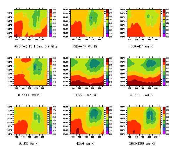
1 AMMA-ALMIP-MEM project soil moisture & μwaves Tb P. de Rosnay, A. Boone, M. Drusch, T. Holmes, G. Balsamo, many others ALMIPers (paper submitted to IGARSS) AMMA-ALMIP-MEM first spatial verification of SM/Tbs C-band AMSR-E C-band Tb HTESSEL Result: HTESSEL+CMEM is un-biased and reproduces satellite obs. statistics! Question: What happens in HTESSEL that deteriorates correlation? 1
2 2
 Land Management and Natural Hazards Unit, Institute for Environment and Sustainability (2) European Centre For Medium Range Weather Forecasts 3")
3 EARLY FLOOD WARNING IN AFRICA: RESULTS OF A FEASIBILITY STUDIES IN THE JUBA, SHABELLE AND ZAMBEZI RIVERS IN AFRICA Ad de Roo 1, Florian Pappenberger 2, Jutta Thielen 1, Vera Thiemig 1 (1) Land Management and Natural Hazards Unit, Institute for Environment and Sustainability (2) European Centre For Medium Range Weather Forecasts 3
 Support: EFAS DG Env, DG Enterprise, European Parlament, Member States Int.")
4 European Flood Alert System (EFAS) Added value information for Member States towards preparedness for flood events 3-10 days in advance Development: JRC since 2003 (following major transnational floods in Europe) Support: EFAS DG Env, DG Enterprise, European Parlament, Member States Int. River Commissions 4


5 /23/020:00 8/24/020:00 8/25/02 0:00 8/26/020:00 8/27/020:00 8/28/02 0:00 8/29/02 0:00 8/30/020:00 8/31/020:00 Dessau/Rosslau Wittenberg Torgau Riesa Dresden Labe Decin Labe/Usti N.L. Vltava/Prague INPUT Schematic view of EFAS EU FLOOD GIS Realtime data Histoical data /23/020:00 8/24/020:00 8/25/02 0:00 8/26/020:00 8/27/02 0:00 8/28/02 0:00 8/29/020:00 8/30/02 0:00 8/31/02 0:00 Dessau/Rosslau Wittenberg Torgau Riesa Dresden Labe Decin Labe/Usti N.L. Vltava/Prague Static data Europ. data Meteo Forecasts EFAS reports Expert knowledge from MS 5
 and Somalia Water and Land Information Management (Juba-")
6 Pilot study: Transfer of EFAS methodologies to Africa different climatic forcing: large scale, long durations little data and catchment descriptions Two pilots: Juba-Shabelle and Zambezi river basins joined projects with Washington State University (Zambezi) and Somalia Water and Land Information Management (Juba- Shabelle) 6

7 Juba-Shabelle River Basin shared between Ethiopia and Somalia km² Altitudes range from 3000 m to sea level mainly natural vegetation such as riparian forest, bush lands and grasslands, but also swamps in collaboration with Somalia Water and Land Information Management (SWALIM) 7
8 Setting up pilot basins for Africa Topography, soil and land use data available at JRC African Observatory River flow data obtained from Global Runoff Data Centre (GRDC/WMO) and African partners, e.g. SWALIM Weather observations (station and satellite data ) from WMO, Washington State University, ECMWF (European Centre for Medium-range Weather Forecasts), and other sources Weather forecasts: ECMWF archived forecasts and reforecasts for 2 events with state-of-the-art model 8

9 Climate in Juba/Shabelle 2 rain seasons 2 dry seasons 9
10 Longterm High and low river levels 7.00 Bankful level 6.00 Belet Weyne river water Level(m) Jan Feb Mar Apr May Jun Jul Aug Sep Oct Nov Dec month LT Mean River Levels Flood Year Bank full Level LT Max River Levels LT Min River Levels 10
11 Historical flood years 1961, 1977, 1981, 1997/8, 2005, 2006 Belet Weyne (Shabelle), observed discharge [m³/s] /1/77 7/1/77 1/1/78 7/1/78 1/1/79 7/1/79 1/1/80 7/1/80 1/1/81 7/1/81 11
12 Long-term mean flows for upstream and downstream stations Discharge (m 3 /s) Juba Luuq Jamame Jan Feb Mar Apr May Jun Jul Aug Sep Oct Nov Dec upstream downstream Shabelle Belet Weyne Awdhegle Discharge (m 3 /s) Jan Feb Mar Apr May Jun Jul Aug Sep Oct Nov Dec Flow reduction from upstream to downstream: over bank spillage and irrigation diversion -> tuning of hydrological model necessary 12
13 VAREPS forecasts for Africa (Feb-Apr 1978) VAREPS ensembles are being run for the period 15 Feb to 15 Apr 1978 (19 cases have been completed). These forecasts are run in the operational configuration, with model cycle 33r1. ICs are defined by ERA-40. Initial perturbations are scaled larger (γ=0.020 instead of 0.014) than in the operational EPS to take into account the fact that ERA-40 T159 analyses are less accurate than operational T799L91 analyses. These plots show the 19-case average error of the ensemble-mean (blue with symbols) and the std (blue) for T850 over NH (left), Europe (middle) and North-west Africa (12.5S λ 35N, Θ 12.5, left). 13
14 Preliminary results for Shabelle (Belet Weyne) 14 1/1/1976 4/1/1976 7/1/ /1/1976 1/1/1977 4/1/1977 7/1/ /1/1977 1/1/1978 4/1/1978 7/1/ /1/1978 1/1/1979 4/1/1979 7/1/ /1/1979 1/1/1980 4/1/1980 7/1/ /1/1980 1/1/1981 4/1/1981 7/1/ /1/1981 Observations exceed critical threshold Simulations exceed critical threshold
15 15 1/1/1976 4/1/1976 7/1/ /1/1976 1/1/1977 4/1/1977 7/1/ /1/1977 1/1/1978 4/1/1978 7/1/ /1/1978 1/1/1979 4/1/1979 7/1/ /1/1979 1/1/1980 4/1/1980 7/1/ /1/1980 1/1/1981 4/1/1981 7/1/ /1/1981 Preliminary results for Juba (Luuq) Observations exceed critical threshold Simulations exceed critical threshold
16 Summary European Flood Alert System (EFAS) methodologies currently tested for African basins (Zambezi and Juba-Shabelle) Challenge to collect data for set-up, testing and verification First results show that observed meteorological fields have much uncertainty weather forecasts for historic events have limited skills data collection is a challenge flood events can be depicted by the simulations Successful set-up can be used for climate change studies 16


17 For more information: Contacts: Action Leader: Ad de Roo Climate Change: Luc Feyen EFAS: Jutta Thielen 17
Explore African and Global early warning systems Climate Change effects on water cycle: Flood Risk. Revised website:
 JRC research activities on floods 1 Flood early warning (Europe) EFAS: European Flood Alert System IMPRINTS (DG RTD project): flash flood early warning EU-FLOOD-GIS ETN-R Explore African and Global early
Satellite data for hydrological forecasting
 Satellite data for hydrological forecasting Current use at ECMWF and perspective Shopping list! Our current tools does not allow direct use, but could be modified Christel Prudhomme Christel.prudhomme@ecmwf.int
Crisis Management and Natural Disasters Overview of JRC operational or pre-operational activities A. Annunziato, D. Al-Khudhairy
 Papagayo, Costarica 3-4 November 2009 Security Science and The Americas 1 Joint Research Centre (JRC) Crisis Management and Natural Disasters Overview of JRC operational or pre-operational activities A.
Flood Forecasting. Fredrik Wetterhall European Centre for Medium-Range Weather Forecasts
 Flood Forecasting Fredrik Wetterhall (fredrik.wetterhall@ecmwf.int) European Centre for Medium-Range Weather Forecasts Slide 1 Flooding a global challenge Number of floods Slide 2 Flooding a global challenge
C o p e r n i c u s E m e r g e n c y M a n a g e m e n t S e r v i c e f o r e c a s t i n g f l o o d s
 C o p e r n i c u s E m e r g e n c y M a n a g e m e n t S e r v i c e f o r e c a s t i n g f l o o d s Copernicus & Copernicus Services Copernicus EU Copernicus EU Copernicus EU www.copernicus.eu W
Land surface modelling activity at ECMWF
 Land surface modelling activity at ECMWF Gianpaolo Balsamo Outline Land surface hydrology Soil moisture sensitivity Carbon and vegetation Cold processes In-land water bodies and SSTs Land assimilation
GAMINGRE 8/1/ of 7
 FYE 09/30/92 JULY 92 0.00 254,550.00 0.00 0 0 0 0 0 0 0 0 0 254,550.00 0.00 0.00 0.00 0.00 254,550.00 AUG 10,616,710.31 5,299.95 845,656.83 84,565.68 61,084.86 23,480.82 339,734.73 135,893.89 67,946.95
Seasonal Hydrometeorological Ensemble Prediction System: Forecast of Irrigation Potentials in Denmark
 Seasonal Hydrometeorological Ensemble Prediction System: Forecast of Irrigation Potentials in Denmark Diana Lucatero 1*, Henrik Madsen 2, Karsten H. Jensen 1, Jens C. Refsgaard 3, Jacob Kidmose 3 1 University
Gu 2017 Rainfall Performance
 Gu 217 Rainfall Performance Summary March June 217 Issued: 28 June 217 Somalia is in the second year of a severe drought the kind that is increasingly likely as the climate warms. Somali communities were
COUPLING A DISTRIBUTED HYDROLOGICAL MODEL TO REGIONAL CLIMATE MODEL OUTPUT: AN EVALUATION OF EXPERIMENTS FOR THE RHINE BASIN IN EUROPE
 P.1 COUPLING A DISTRIBUTED HYDROLOGICAL MODEL TO REGIONAL CLIMATE MODEL OUTPUT: AN EVALUATION OF EXPERIMENTS FOR THE RHINE BASIN IN EUROPE Jan Kleinn*, Christoph Frei, Joachim Gurtz, Pier Luigi Vidale,
Global Flood Awareness System GloFAS
 Global Flood Awareness System GloFAS Ervin Zsoter with the help of the whole EFAS/GloFAS team Ervin.Zsoter@ecmwf.int 1 Reading, 8-9 May 2018 What is GloFAS? Global-scale ensemble-based flood forecasting
Joint Research Centre (JRC)
") Toulouse on 15/06/2009-HEPEX 1 Joint Research Centre (JRC) Comparison of the different inputs and outputs of hydrologic prediction system - the full sets of Ensemble Prediction System (EPS), the reforecast
Toulouse on 15/06/2009-HEPEX 1 Joint Research Centre (JRC) Comparison of the different inputs and outputs of hydrologic prediction system - the full sets of Ensemble Prediction System (EPS), the reforecast
Chiang Rai Province CC Threat overview AAS1109 Mekong ARCC
 Chiang Rai Province CC Threat overview AAS1109 Mekong ARCC This threat overview relies on projections of future climate change in the Mekong Basin for the period 2045-2069 compared to a baseline of 1980-2005.
Impacts of climate change on flooding in the river Meuse
 Impacts of climate change on flooding in the river Meuse Martijn Booij University of Twente,, The Netherlands m.j.booij booij@utwente.nlnl 2003 in the Meuse basin Model appropriateness Appropriate model
ECMWF and Copernicus outputs in support of multi-hazard Early Warning Systems in Member and Co-Operating States
 ECMWF and Copernicus outputs in support of multi-hazard Early Warning Systems in Member and Co-Operating States David Richardson Head of Evaluation Section, Forecast Department, ECMWF david.richardson@ecmwf.int
Hazard assessment based on radar-based rainfall nowcasts at European scale The HAREN project
 Hazard assessment based on radar-based rainfall nowcasts at European scale The HAREN project Marc Berenguer, Daniel Sempere-Torres 3 OPERA radar mosaic OPERA radar mosaic: 213919 133 Precipitation observations
The Global Flood Awareness System
 The Global Flood Awareness System David Muraro, Gabriele Mantovani and Florian Pappenberger www.globalfloods.eu 1 Forecasting chain using Ensemble Numerical Weather Predictions Flash Floods / Riverine
2015 Fall Conditions Report
 2015 Fall Conditions Report Prepared by: Hydrologic Forecast Centre Date: December 21 st, 2015 Table of Contents Table of Figures... ii EXECUTIVE SUMMARY... 1 BACKGROUND... 2 SUMMER AND FALL PRECIPITATION...
The 2010/11 drought in the Horn of Africa: Monitoring and forecasts using ECMWF products
 The 2010/11 drought in the Horn of Africa: Monitoring and forecasts using ECMWF products Emanuel Dutra Fredrik Wetterhall Florian Pappenberger Souhail Boussetta Gianpaolo Balsamo Linus Magnusson Slide
Climatic and Ecological Conditions in the Klamath Basin of Southern Oregon and Northern California: Projections for the Future
 Climatic and Ecological Conditions in the Klamath Basin of Southern Oregon and Northern California: Projections for the Future A Collaborative Effort by: CLIMATE LEADERSHIP INITIATIVE INSTITUTE FOR A SUSTAINABLE
Monthly probabilistic drought forecasting using the ECMWF Ensemble system
 Monthly probabilistic drought forecasting using the ECMWF Ensemble system Christophe Lavaysse(1) J. Vogt(1), F. Pappenberger(2) and P. Barbosa(1) (1) European Commission (JRC-IES), Ispra Italy (2) ECMWF,
S e a s o n a l F o r e c a s t i n g f o r t h e E u r o p e a n e n e r g y s e c t o r
 S e a s o n a l F o r e c a s t i n g f o r t h e E u r o p e a n e n e r g y s e c t o r C3S European Climatic Energy Mixes (ECEM) Webinar 18 th Oct 2017 Philip Bett, Met Office Hadley Centre S e a s
The Huong River the nature, climate, hydro-meteorological issues and the AWCI demonstration project
 The Huong River the nature, climate, hydro-meteorological issues and the AWCI demonstration project 7th GEOSS AP Symposium, the AWCI parallel session May 27, 214, Tokyo National Centre for Hydro-Meteorological
Rainfall Update in Somalia 29 April 2016
 Somalia Water and Land Information Management Rainfall Update in Somalia 29 April 2016 Rainfall Update Significant rains have been received in many areas of Somaliland especially in the western regions
DROUGHT INDICES BEING USED FOR THE GREATER HORN OF AFRICA (GHA)
") DROUGHT INDICES BEING USED FOR THE GREATER HORN OF AFRICA (GHA) Christopher Oludhe IGAD Climate Prediction and Applications Centre (ICPAC) Inter-Regional Workshop on Indices and Early Warning Systems for
DROUGHT INDICES BEING USED FOR THE GREATER HORN OF AFRICA (GHA) Christopher Oludhe IGAD Climate Prediction and Applications Centre (ICPAC) Inter-Regional Workshop on Indices and Early Warning Systems for
Drought Monitoring with Hydrological Modelling
 st Joint EARS/JRC International Drought Workshop, Ljubljana,.-5. September 009 Drought Monitoring with Hydrological Modelling Stefan Niemeyer IES - Institute for Environment and Sustainability Ispra -
Modelling and Data Assimilation Needs for improving the representation of Cold Processes at ECMWF
 Modelling and Data Assimilation Needs for improving the representation of Cold Processes at ECMWF presented by Gianpaolo Balsamo with contributions from Patricia de Rosnay, Richard Forbes, Anton Beljaars,
Climate Change and Arizona s Rangelands: Management Challenges and Opportunities
 Climate Change and Arizona s Rangelands: Management Challenges and Opportunities Mike Crimmins Climate Science Extension Specialist Dept. of Soil, Water, & Env. Science & Arizona Cooperative Extension
Climate Change Impact Assessment on Indian Water Resources. Ashvin Gosain, Sandhya Rao, Debajit Basu Ray
 Climate Change Impact Assessment on Indian Water Resources Ashvin Gosain, Sandhya Rao, Debajit Basu Ray Objectives of the Study To quantify the impact of the climate change on the water resources of the
I C P A C. IGAD Climate Prediction and Applications Centre Monthly Climate Bulletin, Climate Review for September 2017
 Bulletin Issue October 2017 I C P A C IGAD Climate Prediction and Applications Centre Monthly Climate Bulletin, Climate Review for September 2017 1. INTRODUCTION This bulletin reviews the September 2017
Global Flood Alert System based on satellite derived rainfall data -Targeting the era of Global Precipitation Measurement (GPM)-
-") Global Flood Alert System based on satellite derived rainfall data -Targeting the era of Global Precipitation Measurement (GPM)- Riko Oki, Misako Kachi (JAXA/EORC) Kazuhiko Fukami (PWRI) and Kazuo Umeda
Global Flood Alert System based on satellite derived rainfall data -Targeting the era of Global Precipitation Measurement (GPM)- Riko Oki, Misako Kachi (JAXA/EORC) Kazuhiko Fukami (PWRI) and Kazuo Umeda
Hydro-meteorological Analysis of Langtang Khola Catchment, Nepal
 Hydro-meteorological Analysis of Langtang Khola Catchment, Nepal Tirtha R. Adhikari 1, Lochan P. Devkota 1, Suresh.C Pradhan 2, Pradeep K. Mool 3 1 Central Department of Hydrology and Meteorology Tribhuvan
Fenhe (Fen He) Map of River. Table of Basic Data. China 10
 Map of River. Table of Basic Data. China 10") Fenhe (Fen He) Map of River Table of Basic Data Name(s): Fenhe (in Huanghe River) Location: Shanxi Province, Northern China Area: 39,471 km 2 Origin: Mt. Guancen (2,147 m) Outlet: Huanghe Serial No. :
Fenhe (Fen He) Map of River Table of Basic Data Name(s): Fenhe (in Huanghe River) Location: Shanxi Province, Northern China Area: 39,471 km 2 Origin: Mt. Guancen (2,147 m) Outlet: Huanghe Serial No. :
Evapo-transpiration Losses Produced by Irrigation in the Snake River Basin, Idaho
 Nov 7, 2007 DRAFT Evapo-transpiration Losses Produced by Irrigation in the Snake River Basin, Idaho Wendell Tangborn and Birbal Rana HyMet Inc. Vashon Island, WA Abstract An estimated 8 MAF (million acre-feet)
Ultra-High Resolution Time Traveling AgMet Information from Seeding to Harvesting
 Ultra-High Resolution Time Traveling AgMet Information from Seeding to Harvesting - seamless data for prospect estimation of crop yields - Dec. 5, 2016 Jai-ho Oh & Kyung-Min Choi Dept. Env. & Atmos. Sci.,
COUNTRY PRESENTATION ON MR JAYNAL ABEDIN JOINT SECRETARY ( WORKS & DEVELOPMENT ) MINISTRY OF DEFENCE
 MINISTRY OF DEFENCE") COUNTRY PRESENTATION ON By MR JAYNAL ABEDIN JOINT SECRETARY ( WORKS & DEVELOPMENT ) MINISTRY OF DEFENCE Bangladesh Geographical Location of Bangladesh Bangladesh Country at a Glance Physical Features 1,230
COUNTRY PRESENTATION ON By MR JAYNAL ABEDIN JOINT SECRETARY ( WORKS & DEVELOPMENT ) MINISTRY OF DEFENCE Bangladesh Geographical Location of Bangladesh Bangladesh Country at a Glance Physical Features 1,230
Promoting Rainwater Harvesting in Caribbean Small Island Developing States Water Availability Mapping for Grenada Preliminary findings
 Promoting Rainwater Harvesting in Caribbean Small Island Developing States Water Availability Mapping for Grenada Preliminary findings National Workshop Pilot Project funded by The United Nations Environment
Climate also has a large influence on how local ecosystems have evolved and how we interact with them.
 The Mississippi River in a Changing Climate By Paul Lehman, P.Eng., General Manager Mississippi Valley Conservation (This article originally appeared in the Mississippi Lakes Association s 212 Mississippi
AN ASSESSMENT OF THE RELATIONSHIP BETWEEN RAINFALL AND LAKE VICTORIA LEVELS IN UGANDA
 AN ASSESSMENT OF THE RELATIONSHIP BETWEEN RAINFALL AND LAKE VICTORIA LEVELS IN UGANDA BY CATHERINE MULINDE BA (Environmental Management), PGD (Meteorology) Teaching Assistant Department of Geography, Meteorology
Flood Inundation Analysis by Using RRI Model For Chindwin River Basin, Myanmar
 Flood Inundation Analysis by Using RRI Model For Chindwin River Basin, Myanmar Aye Aye Naing Supervisor : Dr. Miho Ohara MEE14625 Dr. Duminda Perera Dr. Yoshihiro Shibuo ABSTRACT Floods occur during the
Illinois State Water Survey Division
 Illinois State Water Survey Division SURFACE WATER SECTION SWS Miscellaneous Publication 108 SEDIMENT YIELD AND ACCUMULATION IN THE LOWER CACHE RIVER by Misganaw Demissie Champaign, Illinois June 1989
Drought forecasting methods Blaz Kurnik DESERT Action JRC
 Ljubljana on 24 September 2009 1 st DMCSEE JRC Workshop on Drought Monitoring 1 Drought forecasting methods Blaz Kurnik DESERT Action JRC Motivations for drought forecasting Ljubljana on 24 September 2009
Global Flash Flood Forecasting from the ECMWF Ensemble
 Global Flash Flood Forecasting from the ECMWF Ensemble Calumn Baugh, Toni Jurlina, Christel Prudhomme, Florian Pappenberger calum.baugh@ecmwf.int ECMWF February 14, 2018 Building a Global FF System 1.
I&CLC2000 in support to new policy initiatives (INSPIRE, GMES,..)
") I&CLC2000 in support to new policy initiatives (INSPIRE, GMES,..) Manfred Grasserbauer, Director Joint Research Centre Institute for Environment and Sustainability 1 IMAGE 2000 European mosaic of satellite
I&CLC2000 in support to new policy initiatives (INSPIRE, GMES,..) Manfred Grasserbauer, Director Joint Research Centre Institute for Environment and Sustainability 1 IMAGE 2000 European mosaic of satellite
OVERVIEW OF IMPROVED USE OF RS INDICATORS AT INAM. Domingos Mosquito Patricio
 OVERVIEW OF IMPROVED USE OF RS INDICATORS AT INAM Domingos Mosquito Patricio domingos.mosquito@gmail.com Introduction to Mozambique /INAM Introduction to AGRICAB/SPIRITS Objectives Material & Methods Results
Technical Note: Hydrology of the Lake Chilwa wetland, Malawi
 Technical Note: Hydrology of the Lake Chilwa wetland, Malawi Matthew McCartney June 27 Description Lake Chilwa is located in the Southern region of Malawi on the country s eastern boarder with Mozambique
Seasonal Hydrological Forecasting in the Berg Water Management Area of South Africa
 Seasonal Hydrological Forecasting in the Berg Water Management Area of South Africa Trevor LUMSDEN and Roland SCHULZE University of KwaZulu-Natal, South Africa OUTLINE Introduction Objectives Study Area
Drought forecasting and warning in Africa Some experiences & thoughts from the DEWFORA project
 Drought forecasting and warning in Africa Some experiences & thoughts from the DEWFORA project Micha Werner 1 & Gilbert Ouma 2 1 Deltares & UNESCO-IHE, the Netherlands 2 ICPAC & University of Nairobi,
UK Flooding Feb 2003
 UK Flooding 2000 06 Feb 2003 Britain has taken a battering from floods in the last 5 years, with major events in 1998 and 2000, significant floods in 2001 and minor events in each of the other years. So
EFAS Bulletins. Yearbook Peter Salamon, Jens Bartholmes, Jutta Thielen
 EFAS Bulletins Yearbook 2007 Peter Salamon, Jens Bartholmes, Jutta Thielen EUR 23264 EN - 2008 The mission of the Institute for Environment and Sustainability is to provide scientific-technical support
Technical Note: Hydrology of the Lukanga Swamp, Zambia
 Technical Note: Hydrology of the Lukanga Swamp, Zambia Matthew McCartney July 7 Description The Lukanga swamp is located approximately 5km west of the city of Kabwe, in the Central province of Zambia,
Seasonal Forecasting and Hydrology at ECMWF
 Seasonal Forecasting and Hydrology at ECMWF Florian Pappenberger (florian.pappenberger@ecmwf.int) European Centre for Medium-Range Weather Forecasts FEWS User Meeting in Delft 2008 1/42 Overview Background
APPLICATIONS OF DOWNSCALING: HYDROLOGY AND WATER RESOURCES EXAMPLES
 APPLICATIONS OF DOWNSCALING: HYDROLOGY AND WATER RESOURCES EXAMPLES Dennis P. Lettenmaier Department of Civil and Environmental Engineering For presentation at Workshop on Regional Climate Research NCAR
Assessing bias in satellite rainfall products and their impact in water balance closure at the Zambezi headwaters
 Assessing bias in satellite rainfall products and their impact in water balance closure at the Zambezi headwaters Omondi C.K. 1 Rientjes T.H.M. 1, Haile T.A. 2, Gumindoga W. 1,3 (1) Faculty ITC, University
European Flooding, Summer 2013
 European Flooding, Summer 2013 Fredrik ikwetterhall Florian Pappenberger, Clement Albergel, Lorenzo Alfieri, Gianpaolo Balsamo, Konrad Bogner, Thomas Haiden, Tim Hewson, Linus Magnusson, Patricia de Rosnay,
MJO prediction Intercomparison using the S2S Database Frédéric Vitart (ECMWF)
") MJO prediction Intercomparison using the S2S Database Frédéric Vitart (ECMWF) Slide 1 WGNE Meeting 29 April 2016 1 INDEX The S2S project and S2S Database MJO prediction in S2S models MJO teleconnections
MJO prediction Intercomparison using the S2S Database Frédéric Vitart (ECMWF) Slide 1 WGNE Meeting 29 April 2016 1 INDEX The S2S project and S2S Database MJO prediction in S2S models MJO teleconnections
Probabilistic predictions of monsoon rainfall with the ECMWF Monthly and Seasonal Forecast Systems
 Probabilistic predictions of monsoon rainfall with the ECMWF Monthly and Seasonal Forecast Systems Franco Molteni, Frederic Vitart, Tim Stockdale, Laura Ferranti, Magdalena Balmaseda European Centre for
Seasonal Climate Watch June to October 2018
 Seasonal Climate Watch June to October 2018 Date issued: May 28, 2018 1. Overview The El Niño-Southern Oscillation (ENSO) has now moved into the neutral phase and is expected to rise towards an El Niño
HYDROLOGICAL MODELING OF HIGHLY GLACIERIZED RIVER BASINS. Nina Omani, Raghavan Srinivasan, Patricia Smith, Raghupathy Karthikeyan, Gerald North
 HYDROLOGICAL MODELING OF HIGHLY GLACIERIZED RIVER BASINS Nina Omani, Raghavan Srinivasan, Patricia Smith, Raghupathy Karthikeyan, Gerald North Problem statement Glaciers help to keep the earth cool High
Hydrologic Ensemble Prediction: Challenges and Opportunities
 Hydrologic Ensemble Prediction: Challenges and Opportunities John Schaake (with lots of help from others including: Roberto Buizza, Martyn Clark, Peter Krahe, Tom Hamill, Robert Hartman, Chuck Howard,
ICPAC. IGAD Climate Prediction and Applications Centre Monthly Bulletin, May 2017
 s` ICPAC Bulletin Issue June 2017 Issue Number: ICPAC/02/302 IGAD Climate Prediction and Applications Centre Monthly Bulletin, May 2017 For referencing within this bulletin, the Greater Horn of Africa
Water Management for Environmental Restoration Flows In the Big Bend reach, Rio Grande Rio Bravo
 University of California, Davis Department of Land, Air and Water Resources Water Management for Environmental Restoration Flows In the Big Bend reach, Rio Grande Rio Bravo 46 th Annual Meeting 8 9 March,
El Nino: Outlook VAM-WFP HQ September 2018
 El Nino: Outlook 2018 VAM-WFP HQ September 2018 El Nino Outlook September 2018 2015-16 El Nino Peak Possible evolution of an El Nino indicator (Pacific sea surface temperature anomaly) generated by a diverse
TRENDS AND CHANGE IN CLIMATE OVER THE VOLTA RIVER BASIN
 TRENDS AND CHANGE IN CLIMATE OVER THE VOLTA RIVER BASIN VOLTRES PROJECT WORK PACKAGE 1a: CLIMATE KEY RESULTS E. Obuobie, H.E. Andersen, C. Asante-Sasu, M. Osei-owusu 11/9/217 OBJECTIVES Analyse long term
PRELIMINARY ASSESSMENT OF SURFACE WATER RESOURCES - A STUDY FROM DEDURU OYA BASIN OF SRI LANKA
 PRELIMINARY ASSESSMENT OF SURFACE WATER RESOURCES - A STUDY FROM DEDURU OYA BASIN OF SRI LANKA THUSHARA NAVODANI WICKRAMAARACHCHI Hydrologist, Water Resources Secretariat of Sri Lanka, Room 2-125, BMICH,
Seasonal Climate Watch April to August 2018
 Seasonal Climate Watch April to August 2018 Date issued: Mar 23, 2018 1. Overview The El Niño-Southern Oscillation (ENSO) is expected to weaken from a moderate La Niña phase to a neutral phase through
Role of Hydro-Met Services in Disaster Risk Management
 Role of Hydro-Met Services in Disaster Risk Management Tshewang Rigzin (Mr) National Centre for Hydrology and Meteorology, Bhutan 30 th November 2017 Outline Vision and Mission Functions related to Disaster
Flash Flood Guidance System On-going Enhancements
 Flash Flood Guidance System On-going Enhancements Hydrologic Research Center, USA Technical Developer SAOFFG Steering Committee Meeting 1 10-12 July 2017 Jakarta, INDONESIA Theresa M. Modrick Hansen, PhD
I C P A C. IGAD Climate Prediction and Applications Centre Monthly Climate Bulletin, Climate Review for April 2018
 No. ICPAC/02/312 Bulletin Issue May 2018 I C P A C IGAD Climate Prediction and Applications Centre Monthly Climate Bulletin, Climate Review for April 2018 1. INTRODUCTION This bulletin reviews the April
Introduction to TIGGE and GIFS. Richard Swinbank, with thanks to members of GIFS-TIGGE WG & THORPEX IPO
 Introduction to TIGGE and GIFS Richard Swinbank, with thanks to members of GIFS-TIGGE WG & THORPEX IPO GIFS-TIGGE/NCAR/NOAA Workshop on EPS developments, June 2012 TIGGE THORPEX Interactive Grand Global
Regional Flash Flood Guidance and Early Warning System
 WMO Training for Trainers Workshop on Integrated approach to flash flood and flood risk management 24-28 October 2010 Kathmandu, Nepal Regional Flash Flood Guidance and Early Warning System Dr. W. E. Grabs
Inflow Forecasting for Hydro Catchments. Ross Woods and Alistair McKerchar NIWA Christchurch
 Inflow Forecasting for Hydro Catchments Ross Woods and Alistair McKerchar NIWA Christchurch Inflows Water flowing into hydro storages Usually measured by monitoring the levels and outflows from hydro storages
LINKING SEASONAL FORECASTS TO USER NEEDS IN THE LIMPOPO BASIN IN SOUTHERN AFRICA
 LINKING SEASONAL FORECASTS TO USER NEEDS IN THE LIMPOPO BASIN IN SOUTHERN AFRICA Micha Werner 1,2* Patricia Trambauer 2 Hessel Winsemius 1 Shreedhar Maskey 2 Florian Pappenberger 3 Emanuel Dutra 3 Plus
HYDROLOGIC AND WATER RESOURCES EVALUATIONS FOR SG. LUI WATERSHED
 HYDROLOGIC AND WATER RESOURCES EVALUATIONS FOR SG. LUI WATERSHED 1.0 Introduction The Sg. Lui watershed is the upper part of Langat River Basin, in the state of Selangor which located approximately 20
Life Cycle of Convective Systems over Western Colombia
 Life Cycle of Convective Systems over Western Colombia Meiry Sakamoto Uiversidade de São Paulo, São Paulo, Brazil Colombia Life Cycle of Convective Systems over Western Colombia Convective System (CS)
A Synoptic Climatology of Heavy Precipitation Events in California
 A Synoptic Climatology of Heavy Precipitation Events in California Alan Haynes Hydrometeorological Analysis and Support (HAS) Forecaster National Weather Service California-Nevada River Forecast Center
Sub-seasonal predictions at ECMWF and links with international programmes
 Sub-seasonal predictions at ECMWF and links with international programmes Frederic Vitart and Franco Molteni ECMWF, Reading, U.K. Using ECMWF forecasts, 4-6 June 2014 1 Outline Recent progress and plans
I C P A C IGAD Climate Prediction & Applications centre
 s` I C P A C IGAD Climate Prediction & Applications centre Bulletin Issue July 2017 Issue Number: ICPAC/02/303 IGAD Climate Prediction and Applications Centre Monthly Climate Bulletin, June 2017 1. INTRODUCTION
Rong Jiang. Map of River. Table of Basic Data. China 14. Serial No. : China-14
 Rong Jiang Map of River Table of Basic Data Name(s): Rong Jiang Location: Guangdong Province, Coastways China Area: 4,408 km 2 Serial No. : China-14 N 23 11' ~ 23 55' E 115 37' ~ 116 38' Length of the
Application of Satellite Data for Flood Forecasting and Early Warning in the Mekong River Basin in South-east Asia
 MEKONG RIVER COMMISSION Vientiane, Lao PDR Application of Satellite Data for Flood Forecasting and Early Warning in the Mekong River Basin in South-east Asia 4 th World Water Forum March 2006 Mexico City,
FLORA: FLood estimation and forecast in complex Orographic areas for Risk mitigation in the Alpine space
 Natural Risk Management in a changing climate: Experiences in Adaptation Strategies from some European Projekts Milano - December 14 th, 2011 FLORA: FLood estimation and forecast in complex Orographic
Extended Kalman Filter soil-moisture analysis in the IFS
 from Newsletter Number 127 Spring 211 METEOROLOGY Extended Kalman Filter soil-moisture analysis in the IFS doi:1.21957/ik7co53s This article appeared in the Meteorology section of ECMWF Newsletter No.
GLACIER AND SNOWMELT MODELLING USING SWAT: GANGA BASIN CASE STUDY. INRM Consultants Pvt. Ltd.
 GLACIER AND SNOWMELT MODELLING USING SWAT: GANGA BASIN CASE STUDY INRM Consultants Pvt. Ltd. Introduction Snowmelt Runoff contribution in the Himalayan Rivers Estimation of Average contribution of Snowmelt
Supplementary appendix
 Supplementary appendix This appendix formed part of the original submission and has been peer reviewed. We post it as supplied by the authors. Supplement to: Lowe R, Stewart-Ibarra AM, Petrova D, et al.
SAWIDRA Southern Africa
 SAWIDRA Southern Africa Presenter: Thembani Moitlhobogi Assistant Database and IT Expert SADC Climate Services Centre 13 th EUMETSAT Forum in Africa 24-28 September 2018, Abidjan, Cote d Ivoire Context
PRELIMINARY DRAFT FOR DISCUSSION PURPOSES
 Memorandum To: David Thompson From: John Haapala CC: Dan McDonald Bob Montgomery Date: February 24, 2003 File #: 1003551 Re: Lake Wenatchee Historic Water Levels, Operation Model, and Flood Operation This
Three main areas of work:
 Task 2: Climate Information 1 Task 2: Climate Information Three main areas of work: Collect historical and projected weather and climate data Conduct storm surge and wave modeling, sea-level rise (SLR)
JOINT BRIEFING TO THE MEMBERS. El Niño 2018/19 Likelihood and potential impact
 JOINT BRIEFING TO THE MEMBERS El Niño 2018/19 Likelihood and potential impact CURRENT EL NIÑO OUTLOOK (SEPTEMBER 2018) CPC/IRI ENSO Forecast from September. Red bars denote probability of an El Nino developing
Study of Hydrometeorology in a Hard Rock Terrain, Kadirischist Belt Area, Anantapur District, Andhra Pradesh
 Open Journal of Geology, 2012, 2, 294-300 http://dx.doi.org/10.4236/ojg.2012.24028 Published Online October 2012 (http://www.scirp.org/journal/ojg) Study of Hydrometeorology in a Hard Rock Terrain, Kadirischist
Model error and seasonal forecasting
 Model error and seasonal forecasting Antje Weisheimer European Centre for Medium-Range Weather Forecasts ECMWF, Reading, UK with thanks to Paco Doblas-Reyes and Tim Palmer Model error and model uncertainty
Influence of rainfall space-time variability over the Ouémé basin in Benin
 102 Remote Sensing and GIS for Hydrology and Water Resources (IAHS Publ. 368, 2015) (Proceedings RSHS14 and ICGRHWE14, Guangzhou, China, August 2014). Influence of rainfall space-time variability over
Geostatistical Analysis of Rainfall Temperature and Evaporation Data of Owerri for Ten Years
 Atmospheric and Climate Sciences, 2012, 2, 196-205 http://dx.doi.org/10.4236/acs.2012.22020 Published Online April 2012 (http://www.scirp.org/journal/acs) Geostatistical Analysis of Rainfall Temperature
Webinar and Weekly Summary February 15th, 2011
 Webinar and Weekly Summary February 15th, 2011 -Assessment of current water conditions - Precipitation Forecast - Recommendations for Drought Monitor Upper Colorado Normal Precipitation Upper Colorado
On the presence of tropical vortices over the Southeast Asian Sea- Maritime Continent region
 Technical Conference of 50 th Annual Session of Typhoon Committee 2018 On the presence of tropical vortices over the Southeast Asian Sea- Maritime Continent region Nguyen Dang-Quang 1, James Renwick 2,
REMOTELY SENSED INFORMATION FOR CROP MONITORING AND FOOD SECURITY
 LEARNING OBJECTIVES Lesson 4 Methods and Analysis 2: Rainfall and NDVI Seasonal Graphs At the end of the lesson, you will be able to: understand seasonal graphs for rainfall and NDVI; describe the concept
Land data assimilation in the NASA GEOS-5 system: Status and challenges
 Blueprints for Next-Generation Data Assimilation Systems Boulder, CO, USA 8-10 March 2016 Land data assimilation in the NASA GEOS-5 system: Status and challenges Rolf Reichle Clara Draper, Ricardo Todling,
Dust storm variability over EGYPT By Fathy M ELashmawy Egyptian Meteorological Authority
 WMO WORKSHOP ON CLIMATE MONITORING INCLUDING THE IMPLEMENTATION OF CLIMATE WATCH SYSTEMS FOR ARAB COUNTRIES IN WEST ASIA, AMMAN, JORDAN, 27-29 MAY 2013 Dust storm variability over EGYPT By Fathy M ELashmawy
Flood Finder Chad 2017
 Flood Finder Chad 217 Bulletin N 12 19 October 217 Flood Finder alert system is operational using observed water level data. Based on hydrological forecast, flood alerts are issued at N DJamena, Bongor,
Fire danger: the predictive skill provided by ECMWF Integrated forecasting System (IFS)
") Fire danger: the predictive skill provided by ECMWF Integrated forecasting System (IFS) Francesca Di Giuseppe and the fire group at ECMWF ECMWF, Reading, UK F.DiGiuseppe@ecmwf.int ECMWF April 21, 2017
Fire danger: the predictive skill provided by ECMWF Integrated forecasting System (IFS) Francesca Di Giuseppe and the fire group at ECMWF ECMWF, Reading, UK F.DiGiuseppe@ecmwf.int ECMWF April 21, 2017
Global climate predictions: forecast drift and bias adjustment issues
 www.bsc.es Ispra, 23 May 2017 Global climate predictions: forecast drift and bias adjustment issues Francisco J. Doblas-Reyes BSC Earth Sciences Department and ICREA Many of the ideas in this presentation