Kansas Record Hail and the Power of Social Media
|
|
|
- Janice Anderson
- 6 years ago
- Views:
Transcription

1 Kansas Record Hail and the Power of Social Media Scott F. Blair Jared W. Leighton NOAA/National Weather Service, Topeka, Kansas
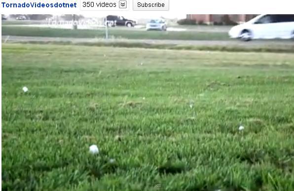
 over expansive swath State record diameter hail size certified (7.75 in.")
2 15 September 2010 Long-lived supercell (~6 hours) tracked from Reno County KS to Osage County OK Prolific large hail producer (2.75+ in.) over expansive swath State record diameter hail size certified (7.75 in.) A few weak tornadoes (EF0) confirmed along w/ areas of wind damage Introduction
3 15 September 2010 Long-lived supercell (~6 hours) tracked from Reno County KS to Osage County OK Prolific large hail producer (2.75+ in.) over expansive swath State record diameter hail size certified (7.75 in.) A few weak tornadoes (EF0) confirmed along w/ areas of wind damage Introduction
 signals Results of NWS Hail Survey (9/16/10) Social media utility in physical science Reconstructing the Hail-Fall Character with all available")
4 Overview Abbreviated radar-based analysis investigating giant hail (>4.00 in.) signals Results of NWS Hail Survey (9/16/10) Social media utility in physical science Reconstructing the Hail-Fall Character with all available tools for future analysis Additional findings derived from social media data


5 Mid-Level Structure KICT 2220 Z KVNX 2223 Z KTWX 2221 Z KDDC 2222 Z 20,000 ft 24,000 ft 22,000 ft 15,000 ft
6 Giant Hail Characteristics VNX VNX Rotational Velocity V r = ( Vmin + Vmax ) / 2 V r = 69 kts (35.5 m s -1 ) ft (7000 m) Storm-Top Divergence STD = ( Vmin + Vmax ) STD = 173 kts (89 m s -1 ) Maximum dbz Heights 50 dbz ~50500 ft 55 dbz ~45000 ft 60 dbz ~39500 ft


7 Giant Hail Characteristics VNX VNX
 Focus on high-density reports in maximum hail size locations (improve resolution / identify larger) If residents preserved stones, diameter, circumference, and weight were measured and recorded")
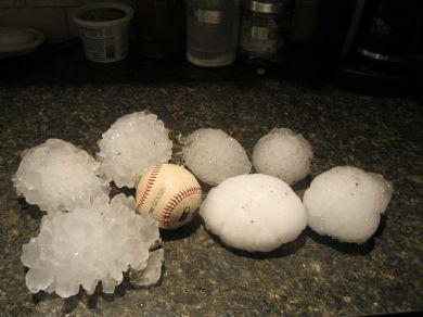
8 NWS Hail Survey Conducted due to initial reports of remarkably giant hail (7.00+ in.), urban area opportunity, and ongoing hail research Garden Plain / Goddard / Wichita Mid-Continent Airport (~15 mi. path) Focus on high-density reports in maximum hail size locations (improve resolution / identify larger) If residents preserved stones, diameter, circumference, and weight were measured and recorded Assisted WFO ICT with official measurements of record stone

9 NWS Hail Survey Established contact with ~60 residents Approximately 80% preserved stones in freezers (some melting/sublimation) Primary motivation insurance-driven (desired proof ). Some stones did not fit in the freezer. All maximum diameter stones > 2.50 in. with median 4.00 in. Largest diameter stone 6.00 in. Significant property damage, stones broke through plywood roofs and wooden decks Reports to NWS (0%), media (6%)

10 Social Media Forms of electronic communication through which users create online communities to share information, ideas, personal messages, and other content (as videos). Merriam-Webster The creation, exchange, and interaction of user-generated content. Communication Blogger, ExpressionEngine, LiveJournal, Open Diary, TypePad, Vox, Google+, WordPress, Xanga, FMyLife, Foursquare, Jaiku, Plurk, Posterous, Tumblr, Twitter, Qaiku, Google Buzz, Identi.ca Nasza-Klasa.pl, Dailybooth, Geoloqi, Gowalla, Facebook places, The Hotlist, Google Latitude, ASmallWorld, Bebo, Cyworld, Diaspora, Facebook, Tuenti, Hi5, Hyves, LinkedIn, MySpace, Ning, Orkut, Plaxo, Tagged, XING, IRC, Yammer Multimedia deviantart, Flickr, Photobucket, Picasa, SmugMug, Zooomr, sevenload, Viddler, Vimeo, YouTube, Dailymotion, Metacafe, Nico Nico Douga, Openfilm, Justin.tv, Livestream, OpenCU, Skype, Stickam, Ustream, blip.tv, oovoo
11 Social Media and NWS Operations Real-time applications of social media becoming realized. Direct or indirect dissemination of warning information across a very wide audience (personalize the threat). Real-time severe weather reports (e.g. 9/15/10) What are the post-storm benefits of social media? Additional verification of NWS warnings Substantial contribution to the physical science (e.g. what we ve been missing ) Low-resolution Storm Data High-resolution SHAVE, HailSTONE NWS verification practices are designed to efficiently verify warnings, not to satisfy scientific studies Due to the method of verification the largest hail to reach the ground is often not found. Amburn and Wolf (1997) 0 mi 3 mi 6 mi 0 mi 3 mi 6 mi


 Recorded maximum diameter hail size")
, removed duplicates Contacted")
12 Reconstructing the Hail-Fall Character Created lat/lon data for each report from NWS LSRs, NWS hail survey, and social media Utilized intersections from user content (Maize Rd and Haskell St) Majority of photos measured the stone or provided a common-size object for comparison (noted M vs. E) Recorded maximum diameter hail size in each photo (0.25 res), removed duplicates Contacted YouTube users for additional specifics
13 Reconstructing the Hail-Fall Character NWS LSR Hail Survey Social Media
14 Reconstructing the Hail-Fall Character NWS LSR Hail Survey Social Media
15 Reconstructing the Hail-Fall Character NWS LSR Hail Survey Social Media

16 Reconstructing the Hail-Fall Character NWS LSR Hail Survey Social Media
17 Reconstructing the Hail-Fall Character

18 Reconstructing the Hail-Fall Character Inverse Distance Weighted interpolation in in in in in.
19 Reconstructing the Hail-Fall Character Rare high-resolution (giant hail) dataset Extremely high spatial, no temporal Only efforts of SHAVE and HailSTONE comparable (limited domain / operations) 479 Data Points: 387 Social Media, 47 NWS Hail Survey, 45 NWS LSR Photos available for 90% of all hail data points Resolution critical to accurately gauge hail-fall behavior and discriminate sensitive changes in storm-scale and radar-based signatures
 15 September 2010 Wichita, KS Diameter: 7.75 in. (197 mm) Weight: 1.10 lb (499 g)* Circumference: 15.5 in. (394 mm)* *Measured 15 hours post-storm")
20 Kansas Record Hail 3 September 1970 Coffeyville, KS Diameter: 5.67 in. (144 mm) Weight: 1.68 lb (765 g) Circumference: 17.5 in. (445 mm) 15 September 2010 Wichita, KS Diameter: 7.75 in. (197 mm) Weight: 1.10 lb (499 g)* Circumference: 15.5 in. (394 mm)* *Measured 15 hours post-storm
21 Kansas Record Hail Eight hail stones were identified that exceeded the previous record diameter All stones originated from the hail survey or social media (Hail Survey, KSN, KAKE, KWCH, Kansas.com, YouTube) Hail stone diameter > 5.67 in. Growing photo and video technologies and usage of social media are allowing us to observe and document meteorological events that were unreported in the past.


22 7.75 in in in in in in in in.
23 Distribution of SM Hail Reports
24 Distribution of SM Hail Reports Jewell and Brimelow (2009) Approximately 36% of uploaded stones in. The availability of photos for each report eliminates potential spotter errors and coin/common size object biases (high scientific value) Insight to what residents find significant enough to upload/report (function of hail size or specific event-driven? smaller hail in some areas not uploaded)
 NWS Hail Survey revealed additional data available post-storm Significant contribution of Social Media in physical science Recreation of the 15 Sept 2010 hail-fall character one of the highest")
25 Summary and Future Work Radar-based signals satisfied characteristics of giant hail producing storms (4.00+ in.) NWS Hail Survey revealed additional data available post-storm Significant contribution of Social Media in physical science Recreation of the 15 Sept 2010 hail-fall character one of the highest spatial resolution datasets available Additional benefits of actual photographic documentation for nearly all hail data points (8 record stones / eliminates biases) High-resolution hail datasets critical for meaningful hail research Continued radar-based analysis on 15 Sept 2010 dataset Acknowledgements George Phillips (NWS TOP), Ken Cook and Chance Hayes (NWS ICT) KAKE, KSN, KWCH, The Wichita Eagle, Twitter, The Weather Channel, YouTube
7 WSR-88D OBSERVATIONS OF AN EXTREME HAIL EVENT IMPACTING ABILENE, TX ON 12 JUNE 2014
 28TH CONFERENCE ON SEVERE LOCAL STORMS 7 WSR-88D OBSERVATIONS OF AN EXTREME HAIL EVENT IMPACTING ABILENE, TX ON 12 JUNE 2014 ARTHUR WITT * NOAA/National Severe Storms Laboratory, Norman, OK MIKE JOHNSON
4B.3 ENHANCED, HIGH-DENSITY SEVERE STORM VERIFICATION. Travis M. Smith, Kiel L. Ortega and Angelyn G. Kolodziej
 4B.3 ENHANCED, HIGH-DENSITY SEVERE STORM VERIFICATION Travis M. Smith, Kiel L. Ortega and Angelyn G. Kolodziej Cooperate Institute for Mesoscale Meteorological Studies, University of Oklahoma (also affiliated
165 HIGH-RESOLUTION PHASED ARRAY RADAR OBSERVATIONS OF AN OKLAHOMA HAILSTORM PRODUCING EXTREMELY-LARGE HAIL
 27TH CONFERENCE ON SEVERE LOCAL STORMS 165 HIGH-RESOLUTION PHASED ARRAY RADAR OBSERVATIONS OF AN OKLAHOMA HAILSTORM PRODUCING EXTREMELY-LARGE HAIL ARTHUR WITT NOAA/National Severe Storms Laboratory, Norman,
The Wind Hazard: Messaging the Wind Threat & Corresponding Potential Impacts
 The Wind Hazard: Messaging the Wind Threat & Corresponding Potential Impacts Scott Spratt Warning Coordination Meteorologist NWS Melbourne, FL David Sharp Science & Operations Officer NWS Melbourne, FL
The Integrated Warning Partnership: Opportunities for Improved Community-Level Benefits. Dale Morris Oklahoma Climatological Survey April 18, 2006
 The Integrated Warning Partnership: Opportunities for Improved Community-Level Benefits Dale Morris Oklahoma Climatological Survey April 18, 2006 My Personal Motivation Sunday Evening, September 5, 1992
Impact Based Warning Tornado - Infrastructure
 National Weather Service Impact Based Warning Tornado - Infrastructure Jim Kramper Warning Coordination Meteorologist St. Louis, MO NOAA s National Weather Service 2011 was a devastating year for tornado
We Had No Warning An Overview of Available Forecast Products Before and During Severe Weather Events
 We Had No Warning An Overview of Available Forecast Products Before and During Severe Weather Events Two main sources for severe weather info NOAA/NWS Storm Prediction Center (SPC) Convective Outlooks
Ken R. Waters. NOAA/National Weather Service Honolulu, Hawaii
 4.B1 VERIFICATION OF NATIONAL WEATHER SERVICE WARNINGS USING GEOGRAPHIC INFORMATION SYSTEMS Ken R. Waters NOAA/National Weather Service Honolulu, Hawaii 1. INTRODUCTION The NOAA/National Weather Service
The NOAA/NWS Warning Decision Training Branch (WDTB): On-line Training Resources for Emergency Managers & Intro to Dual-Polarization Radar
: On-line Training Resources for Emergency Managers & Intro to Dual-Polarization Radar") The NOAA/NWS Warning Decision Training Branch (WDTB): On-line Training Resources for Emergency Managers & Intro to Dual-Polarization Radar Andy Wood CIMMS (University of Oklahoma)/ WDTB (NOAA/NWS) The
The NOAA/NWS Warning Decision Training Branch (WDTB): On-line Training Resources for Emergency Managers & Intro to Dual-Polarization Radar Andy Wood CIMMS (University of Oklahoma)/ WDTB (NOAA/NWS) The
SOCIAL MEDIA IN THE COMMUNICATIONS CENTRE
 SOCIAL MEDIA IN THE COMMUNICATIONS CENTRE Karen Gordon Gordon Strategy www.gordonstrategy.ca v 1 WHAT WE ARE GOING TO TALK ABOUT TODAY T h e s o c i a l m e d i a i n c i d e n t W h a t c a n h a p p
Charles Kuster Leadville, CO. Personal Overview
 Charles Kuster Leadville, CO Personal Overview Personal Overview Charles Kuster Leadville, CO OU to study meteorology Charles Kuster Leadville, CO Personal Overview OU to study meteorology Graduated in
15.3A TORNADO VISUALIZATION AND DOPPLER RADAR ANALYSIS PROJECT. Thomas Dolan * Independent Geographer, Rocklin, CA
 15.3A TORNADO VISUALIZATION AND DOPPLER RADAR ANALYSIS PROJECT Thomas Dolan * Independent Geographer, Rocklin, CA 1. INTRODUCTION Tornadoes play a significant role in the weather of the United States and
SUPER-RAPID SCAN SATELLITE IMAGERY ANALYSIS OF TWO HAILSTORMS SAMPLED BY HAILSTONE
 SUPER-RAPID SCAN SATELLITE IMAGERY ANALYSIS OF TWO HAILSTORMS SAMPLED BY HAILSTONE Jennifer M. Laflin* and Scott F. Blair NOAA/NWS Kansas City/Pleasant Hill, Missouri Chad Gravelle NOAA/NWS Operations
KANSAS CLIMATE SUMMARY June 2018
 KANSAS CLIMATE SUMMARY June 2018 Continued Heat While the heat wasn t as dramatic as in May, June still came in as the 7 th warmest since 1895. The statewide average for the month was 77.9 o F. This was
Andy Bailey National Weather Service Forecast Office Pleasant Hill / Kansas City
 Andy Bailey National Weather Service Forecast Office Pleasant Hill / Kansas City Agenda Why we do surveys Tools we use to conduct surveys What the damage can tell us about the storm Anatomy of a Survey
Radar Network for Urban Flood and Severe Weather Monitoring
 Radar Network for Urban Flood and Severe Weather Monitoring V. Chandrasekar 1 and Brenda Philips 2 Colorado State University, United States University of Massachusetts, United States And the full DFW team
THE CRUCIAL ROLE OF TORNADO WATCHES IN THE ISSUANCE OF WARNINGS FOR SIGNIFICANT TORNADOS
 THE CRUCIAL ROLE OF TORNADO WATCHES IN THE ISSUANCE OF WARNINGS FOR SIGNIFICANT TORNADOS John E. Hales, Jr. National Severe Storms Forecast Center Kansas City, Missouri Abstract The tornado warning is
Title: Storm of the Century: Documenting the 1993 Superstorm
 A. PAIIF 2011 Cover Page Title: Storm of the Century: Documenting the 1993 Superstorm Point of Contact: Name: Alex Granger Email: alex.granger@noaa.gov Phone Number: 571-555-9278 Mailing Address: Research
National Weather Service
 National Weather Service Integrated Warning Team Workshops: NWS Warnings and Outdoor Warning Sirens Tim Halbach Warning Coordination Meteorologist Milwaukee NWS Integrated Warning Team NWS State Officials
Pennsylvania Severe Weather of September 2016
 Pennsylvania Severe Weather of September 2016 By Richard H. Grumm National Weather Service State College, PA 1. Overview September 2016 was a relatively quiet month for severe weather across most of the
TDS look-alike signatures along the leading edge of QLCSs and implications for warning decisions
 TDS look-alike signatures along the leading edge of QLCSs and implications for warning decisions 3 rd Midwest Bow Echo Workshop March 2017 St. Louis, MO Lewis Kanofsky NWS St. Louis, MO 1817z 1817z 1817z
Tornadoes Impacting Interstates: Service and Societal Considerations
 Tornadoes Impacting Interstates: Service and Societal Considerations Scott F. Blair NOAA / National Weather Service, Topeka, Kansas Elizabeth P. K. Lunde NOAA / National Weather Service, Topeka, Kansas
Measuring Hail and Wind Ground-Truth to Facilitate Rapid Response
 Measuring Hail and Wind Ground-Truth to Facilitate Rapid Response Alex Kubicek CEO and Co founder Understory Weather alex.kubicek@understoryweather.com Overview Introduction to Understory Understory technology
Communications and Lessons Learned from
 Weather Forecast Office Charleston, SC Communications and Lessons Learned from Southeast and Caribbean and Climate Community of Practice - April, 2017 Public Information and Communications During Extremes
4/18/2010. National Weather Service. Severe Weather Forecasting: A Western North Carolina Case Study
 National Weather Service Severe Weather Forecasting: A Western North Carolina Case Study Laurence G. Lee Science and Operations Officer National Weather Service Greer, SC Plus 13 River Forecast Centers
Enhancing Weather Information with Probability Forecasts. An Information Statement of the American Meteorological Society
 Enhancing Weather Information with Probability Forecasts An Information Statement of the American Meteorological Society (Adopted by AMS Council on 12 May 2008) Bull. Amer. Meteor. Soc., 89 Summary This
NWS Resources For School Districts
 NWS Resources For School Districts January 23rd, 2017 Shawn DeVinny shawn.devinny@noaa.gov Meteorologist National Weather Service Twin Cities/Chanhassen, MN Outline Watches/Warnings/Advisories Example
KANSAS CLIMATE SUMMARY April 2017
 KANSAS CLIMATE SUMMARY April 2017 Epic Blizzard While much of the month was warmer than normal, the last week brought a return to cold, wintery weather in the western third of the state, and cold rainy
Fort Rucker Wx Operations
 Spring & Summer Weather Hazards Fort Rucker Wx Operations Overview Hours of Operation OWS vs FRWXOPS Products Services Climatology Seasonal Patterns Seasonal Hazards Hours of Operation Observing 24/7 (automated)
The AIR Severe Thunderstorm Model for the United States
 The AIR Severe Thunderstorm Model for the United States In 2011, six severe thunderstorms generated insured losses of over USD 1 billion each. Total losses from 24 separate outbreaks that year exceeded
16 September 2005 Northern Pennsylvania Supercell Thunderstorm by Richard H. Grumm National Weather Service Office State College, PA 16803
 16 September 2005 Northern Pennsylvania Supercell Thunderstorm by Richard H. Grumm National Weather Service Office State College, PA 16803 1. INTRODUCTION During the afternoon hours of 16 September 2005,
A Comparison of Tornado Warning Lead Times with and without NEXRAD Doppler Radar
 MARCH 1996 B I E R I N G E R A N D R A Y 47 A Comparison of Tornado Warning Lead Times with and without NEXRAD Doppler Radar PAUL BIERINGER AND PETER S. RAY Department of Meteorology, The Florida State
SKYWARN Reporting via Ham Radio. MSUARC, April 10, 2018 Bill Call, KJ4W with assistance from Christine Wielgos, NWS
 SKYWARN Reporting via Ham Radio MSUARC, April 10, 2018 Bill Call, KJ4W with assistance from Christine Wielgos, NWS Topics What is SKYWARN? How to Select a Good Vantage Point, if Mobile What Phenomena Are
KANSAS CLIMATE SUMMARY October 2016
 KANSAS CLIMATE SUMMARY October 2016 Record warmth Temperatures continued the warmer than normal pattern through much of October. The state-wide average temperature was 60.9 of, or 5.6 degrees warmer than
KANSAS CLIMATE SUMMARY June 2017
 KANSAS CLIMATE SUMMARY June 2017 Uneven rainfall The wet May gave way to uneven rainfall in June. The statewide average precipitation was 3.23 inches or 74 percent of normal. The East Central and West
National Weather Service
 National Weather Service Performance and Challenges Warning Systems Kenneth E. Graham Meteorologist-in-Charge New Orleans Busy 2008 Number of Tornadoes Number of Tornado Fatalities *Preliminary So Far
Building A Weather-Ready Nation
 Building A Weather-Ready Nation Steve Runnels National Weather Service Springfield, MO` Photo Credit: Tim Marshall 122 National Weather Service Offices NWS Offices Service Missouri and Warning Coordination
P3.17 THE DEVELOPMENT OF MULTIPLE LOW-LEVEL MESOCYCLONES WITHIN A SUPERCELL. Joshua M. Boustead *1 NOAA/NWS Weather Forecast Office, Topeka, KS
 P3.17 THE DEVELOPMENT OF MULTIPLE LOW-LEVEL MESOCYCLONES WITHIN A SUPERCELL Joshua M. Boustead *1 NOAA/NWS Weather Forecast Office, Topeka, KS Philip N. Schumacher NOAA/NWS Weather Forecaster Office, Sioux
TROPICAL CYCLONE TORNADOES
 TROPICAL CYCLONE TORNADOES 2018 GOVERNOR S HURRICANE CONFERENCE TUESDAY, MAY 15, 2018 WILL ULRICH NWS FORECAST OFFICE MELBOURNE WHERE ARE THE TORNADOES? WHERE ARE THE TORNADOES? C B A WEST MELBOURNE, FL
KANSAS CLIMATE SUMMARY June 2016
 KANSAS CLIMATE SUMMARY June 2016 Summer arrives early June made a quick turn-around with both temperature and precipitation in most of the state. Only the Southwest Division averaged above normal precipitation
50 th Anniversary of the Oak Lawn Tornado
 50 th Anniversary of the Oak Lawn Tornado 2017 DuPage County Advanced Severe Weather Seminar National Weather Service Chicago Mike Bardou Stephen Rodriguez Outline 1967 Belvidere, Lake Zurich, and Oak
KANSAS CLIMATE SUMMARY November 2017
 KANSAS CLIMATE SUMMARY November 2017 Dry The major climate feature for November was the dryness. Statewide average precipitation was just 0.10 inches, which is a 3-way tie for the sixth driest November
Hailstorms evidence from smart-phone users:
 Hailstorms evidence from smart-phone users: Crowd-sourced hail size data over Switzerland Noti Pascal A. Martynov, A. Hering, and O. Martius Bern 21.04.2017 Motivation & Objectives > Is crowd-sourcing
Dr. Amanda Schroeder. NWS Weather Forecast Office Fort Worth, TX. Sustainable Urban Water Workshop University of Texas-Arlington June 4-5, 2015
 Dr. Amanda Schroeder NWS Weather Forecast Office Fort Worth, TX Sustainable Urban Water Workshop University of Texas-Arlington June 4-5, 2015 Outline Communicating the message - official Flood and Flash
Mark Fox Meteorologist NWS Fort Worth, TX
 Mark Fox Meteorologist NWS Fort Worth, TX Mark Fox Meteorologist NWS Fort Worth, TX What does severe really mean? Heavy Rain? Hail? Flooding? Wind? Lightning? What does severe really mean? Photo: Mike
7B.4 EVALUATING A HAIL SIZE DISCRIMINATION ALGORITHM FOR DUAL-POLARIZED WSR-88Ds USING HIGH RESOLUTION REPORTS AND FORECASTER FEEDBACK
 7B.4 EVALUATING A HAIL SIZE DISCRIMINATION ALGORITHM FOR DUAL-POLARIZED WSR-88Ds USING HIGH RESOLUTION REPORTS AND FORECASTER FEEDBACK Kiel L. Ortega 1, Alexander V. Ryzhkov 1, John Krause 1, Pengfei Zhang
KANSAS CLIMATE SUMMARY May 2018
 KANSAS CLIMATE SUMMARY May 2018 From Cold to Hot May came close to setting the record as the hottest since 1895. The state-wide average temperature for the month was 70.6 o F. This was 7.2 degrees warmer
Miami-Dade County Overview
 Miami-Dade County Overview 2,000 square miles World s busiest cruise port 2.6 million residents Second busiest US airport for international travelers Gateway to the Caribbean and Latin America Natural
A Look Back at the 2012 Hurricane Season and a Look Ahead to 2013 & Beyond. Daniel Brown National Hurricane Center Miami, Florida 24 April 2013
 A Look Back at the 2012 Hurricane Season and a Look Ahead to 2013 & Beyond Daniel Brown National Hurricane Center Miami, Florida 24 April 2013 2012 Atlantic Verification Good News- Lots of Accuracy Records
baltrad Mass media Overview
 48 Mass media Overview Weather information disseminated through mass media, like press, TV, and Internet is intended for its recipients, not for the media themselves. Therefore the addressees of the media
May 31, Flood Response Overview
 May 31, 2013 Flood Response Overview Suppression 867 Personnel on three (3) shifts 289 Red Shift (A) 289 Blue Shift (B) 289 Green Shift (C) Department Overview Department Overview EMS: 40,934 False Alarm:
Significant Flooding Expected
 Significant Flooding Expected Decision Support Briefing #5 As of: 9:00 AM September 14, 2018 What Has Changed? Flash Flood Watch now in effect for part of area, will be expanded later today 9/14/2018 9:23
KANSAS CLIMATE SUMMARY August 2015
 KANSAS CLIMATE SUMMARY August 2015 Cool and Dry August was drier than normal in most of the state. State-wide average precipitation was 2.80 inches or 85 percent of normal. The Northeast division of the
P5.3 THE UTILITY OF THREE-DIMENSIONAL RADAR DISPLAYS IN SEVERE WEATHER WARNING OPERATIONS. Daniel D. Nietfeld NOAA/National Weather Service Valley, NE
 P5.3 THE UTILITY OF THREE-DIMENSIONAL RADAR DISPLAYS IN SEVERE WEATHER WARNING OPERATIONS Daniel D. Nietfeld NOAA/National Weather Service Valley, NE 1. INTRODUCTION Traditional methods of interrogating
Hurricane Preparation and Recovery. October 11, 2011 Jon Nance, Chief Engineer, NCDOT
 Hurricane Preparation and Recovery October 11, 2011 Jon Nance, Chief Engineer, NCDOT North Carolina & Severe Weather Our state often bears the brunt of storms, which include: Ice storms Snow storms Heavy
2017 Hurricane Season and Beyond
 2017 Hurricane Season and Beyond Ken Graham National Hurricane Center Building a Weather-Ready Nation Much of U.S. Coast Saw Tropical Wind Watches or Warnings 2017 Hurricane Season Facts and Figures 7th
SURVIVING THE STORM: A Severe Weather Safety Guide for West Texans
 SURVIVING THE STORM: A Severe Weather Safety Guide for West Texans National Weather Service Weather Forecast Office Midland, Texas www.weather.gov/midland Fundamental Definitions WATCH Conditions are favorable
Estimating Clustering Coefficients and Size of Social Networks via Random Walk
 Estimating Clustering Coefficients and Size of Social Networks via Random Walk Stephen J. Hardiman* Capital Fund Management France Liran Katzir Advanced Technology Labs Microsoft Research, Israel *Research
SPC Mission Statement. Tornado in Miami, FL Photo: Miami Herald. What is SPC s Responsibility? More SPC Products. SPC Products
 The NOAA/NWS Storm Prediction Center Adapted from a presentation to UNCA atmospheric science students by David Imy SPC Mission Statement SPC exists to protect life and property of the American people through
Using Cell-Based VIL Density to Identify Severe-Hail Thunderstorms in the Central Appalachians and Middle Ohio Valley
 EASTERN REGION TECHNICAL ATTACHMENT NO. 98-9 OCTOBER, 1998 Using Cell-Based VIL Density to Identify Severe-Hail Thunderstorms in the Central Appalachians and Middle Ohio Valley Nicole M. Belk and Lyle
NOAA S National Weather Service
 NOAA S National Weather Service Elite Concepts of Severe Storm Spotting 2011 Rusty Kapela Milwaukee/Sullivan www.weather.gov/mkx Elite Spotter Outline Review Types of T storms Tornadic Supercell Classic,
NWS Resources For Public Works
 NWS Resources For Public Works August 28th, 2016 Shawn DeVinny shawn.devinny@noaa.gov Meteorologist National Weather Service Twin Cities/Chanhassen, MN 1 APWA 2016 PWX 8/28/2016 National Weather Service
13.2 USING VIRTUAL GLOBES TO IMPROVE SITUATIONAL AWARENESS IN THE NATIONAL WEATHER SERVICE
 13.2 USING VIRTUAL GLOBES TO IMPROVE SITUATIONAL AWARENESS IN THE NATIONAL WEATHER SERVICE Andy Foster* National Weather Service Springfield, Missouri* Keith Stellman National Weather Service Shreveport,
Exam 2 Results (20% toward final grade)
") Exam 2 Results (20% toward final grade) Score between 90-99: 6 students (3 grads, 3 under) Score between 80-89: 2 students Score between 70-79: 3 students Score between 60-69: 2 students Below 59: 1 student
Exam 2 Results (20% toward final grade) Score between 90-99: 6 students (3 grads, 3 under) Score between 80-89: 2 students Score between 70-79: 3 students Score between 60-69: 2 students Below 59: 1 student
The illusion of Storm Based Warnings. Daryl Herzmann Iowa State University
 The illusion of Storm Based Warnings Daryl Herzmann Iowa State University Don t agree with something you see? Do what this guy did! I ll act indignant and ignore you. Why am I so bitter? 1. Old Age 2.
Dual-Pol RadarFirst Lab Exercise
 Dual-Pol RadarFirst Lab Exercise Possible Uses of Dual-Pol Radar Data for Emergency Management Objective: This exercise serves as a first introduction to using dual-pol radar data. In the lab, you will
Our Challenge. It s All Wind 2/16/2017
 2/16/2017 It s All Wind Communicating Damaging Wind & Tornado Threats in an Impact-based Environment Rick Smith - NWS Norman, OK Justin Dougherty Our Challenge Given the history and types of weather threats
EXPERIMENTAL PROBABILISTIC HAZARD INFORMATION IN PRACTICE: RESULTS FROM THE 2008 EWP SPRING PROGRAM
 8A.2 EXPERIMENTAL PROBABILISTIC HAZARD INFORMATION IN PRACTICE: RESULTS FROM THE 28 EWP SPRING PROGRAM Kristin M. Kuhlman 1,2,, Travis M. Smith 1,2, Gregory J. Stumpf 1,2, Kiel L. Ortega 1,2, and Kevin
Severe Weather Watches, Advisories & Warnings
 Severe Weather Watches, Advisories & Warnings Tornado Watch Issued by the Storm Prediction Center when conditions are favorable for the development of severe thunderstorms and tornadoes over a larger-scale
Tornado Structure and Risk. Center for Severe Weather Research. The DOW Perspective
 Photo by Herb Stein Tornado Structure and Risk Center for Severe Weather Research The DOW Perspective Photo by Herb Stein Stationary Radars are too far away to resolve tornado structure Blurry Image By
MET Lecture 29 Tornadoes IV
 MET 4300 Lecture 29 Tornadoes IV Outline Definition, life cycle, & climatology of tornadoes Tornado formation within supercells Tornado formation within nonsupercell thunderstorms Fujita scale Tornado
2/20/2015. Mutual Benefits to the Insurance Industry and Weather Enterprise. Technology rapidly evolved in the 90s. Natural Disaster Survey Report
 John Utech @johnutechwx Severe Weather Operations Director, Oklahoma Steve Piltz @SPiltz Meteorologist in Charge National Weather Service Tulsa Forecast Office Mutual Benefits to the Insurance Industry
EVALUATION AND VERIFICATION OF PUBLIC WEATHER SERVICES. Pablo Santos Meteorologist In Charge National Weather Service Miami, FL
 EVALUATION AND VERIFICATION OF PUBLIC WEATHER SERVICES Pablo Santos Meteorologist In Charge National Weather Service Miami, FL WHAT IS THE MAIN DIFFERENCE BETWEEN A GOVERNMENT WEATHER SERVICE FORECAST
Kentucky Weather Hazards: What is Your Risk?
 Kentucky Weather Hazards: What is Your Risk? Stuart A. Foster State Climatologist for Kentucky 2010 Kentucky Weather Conference Bowling Green, Kentucky January 16, 2010 Perspectives on Kentucky s Climate
New approaches to warning: the role of radar
 New approaches to warning: the role of radar John Handmer Centre for Risk and Community Safety, RMIT University Today The risk we want to reduce, and how much impact can we have on the risk of disasters?
Nurture Nature Center Receives Grant From National Oceanic and Atmospheric Administration To Study Flood Forecast and Warning Tools
 Nurture Nature Center Receives Grant From National Oceanic and Atmospheric Administration To Study Flood Forecast and Warning Tools One of four national awards by National Weather Service to advance weather
KANSAS CLIMATE SUMMARY February 2017
 KANSAS CLIMATE SUMMARY February 2017 Warm and dry February was much warmer and drier than normal. The state-wide average temperature was 41.9 o F, which is 7.9 degrees warmer than normal. This places it
2012 IBHS Hail Field Research Summary
 2012 IBHS Hail Field Research Summary This project provided the first field data about the hardness of hailstones, which is a foundational element of IBHS research effort to characterize damaging hail.
5B.1 OBSERVATIONS OF TORNADOGENESIS USING A MOBILE, PHASED-ARRAY, DOPPLER RADAR
 5B.1 OBSERVATIONS OF TORNADOGENESIS USING A MOBILE, PHASED-ARRAY, DOPPLER RADAR Howard B. Bluestein * and Michael French University of Oklahoma, Norman Ivan Popstefanija ProSensing, Inc., Amherst, Massachusetts
Low-end derecho of 19 August 2017
 Low-end derecho of 19 August 2017 By Richard H. Grumm and Charles Ross National Weather Service State College, PA 1. Overview A cluster of thunderstorms developed in eastern Ohio around 1800 UTC on 19
Photo by Herb Stein. Center for Severe Weather Research. Hurricane Studies. Photo by Herb Stein
 Photo by Herb Stein Center for Severe Weather Research Hurricane Studies Photo by Herb Stein DOW Hurricane Studies (or, what the DOWs do after tornado season is over) Missions are very challenging compared
FLOOD/SCS EVENT, APRIL 28 MAY 4
 REPORT DATE: May 4, 2017 EVENT DATE: April 28-May 4, 2017 FLOOD/SCS EVENT, APRIL 28 MAY 4 Event Summary General Significant Flood Outlook. SOURCE: National Weather Service. A significant severe thunderstorm
How we use social media to communicate weather news
 How we use social media to communicate weather news The editorial met-team at METNorway WGCEF 12.10.2017 Norwegian Meteorological Institute INSTAGRAM - SHARING PICTURES Weather photos, 2-3 times a week.
KANSAS CLIMATE SUMMARY January 2018
 KANSAS CLIMATE SUMMARY January 2018 Some welcome moisture After an extended period with little to no moisture, parts of Kansas recorded some significant precipitation. At Tribune, a small snow event on
10 years after Hurricane Charley
 10 years after Hurricane Charley Hurricane Charley (2004) A Retrospective Scott M. Spratt Warning Coordination Meteorologist NWS Melbourne, FL Florida Governors Hurricane Conference May 15, 2014 11 AM
Recent observations of tornadoes using a mobile, rapid-scan, polarimetric, X-band, Doppler radar
 Recent observations of tornadoes using a mobile, rapid-scan, polarimetric, X-band, Doppler radar Howard B. Bluestein 1, Jeffrey C. Snyder 2, Kyle J. Thiem 1, Zachary B. Wienhoff 1, Jana B. Houser 3, and
P12.6 Multiple Modes of Convection in Moderate to High Wind Shear Environments
 P12.6 Multiple Modes of Convection in Moderate to High Wind Shear Environments Adam J. French and Matthew D. Parker North Carolina State University, Raleigh, North Carolina 1. INTRODUCTION A principle
1st Tornado Photograph
 Lecture 26 Part II Tornados Environment Storm Structure Life Cycle Source of Spin Forecasting Climatology Damage Marilee Thomas of Beaver City, NE took this photograph of her daughter Audra about two miles
Scenario-based Language for Hurricane Decision Support
 Scenario-based Language for Hurricane Decision Support David Sharp NOAA/National Weather Service Melbourne, FL Pablo Santos NOAA/National Weather Service Miami, FL Weather Model Outcomes (as seen on TV)
U.S. WIND, SCS, FLOOD, WINTER WEATHER
 U.S. WIND, SCS, FLOOD, WINTER WEATHER An unusually strong winter storm crossing the Central Plains continues to bring winter weather, strong winds, heavy precipitation and severe thunderstorms to areas
SAMPLE. SITE SPECIFIC WEATHER ANALYSIS Rainfall Report. Bevins Engineering, Inc. Susan M. Benedict. July 1, 2017 REFERENCE:
 SAMPLE SITE SPECIFIC WEATHER ANALYSIS Rainfall Report PREPARED FOR: Bevins Engineering, Inc. Susan M. Benedict July 1, 2017 REFERENCE: DUBOWSKI RESIDENCE / FILE# 11511033 1500 Water Street, Pensacola,
Advanced Spotter Training: Anticipating Severe Weather Threats. Professor Paul Sirvatka College of DuPage Meteorology
 Advanced Spotter Training: Anticipating Severe Weather Threats College of DuPage Meteorology Preparing for Severe Weather Preparedness involves understanding the probable and potential threats. Understanding
Severe Thunderstorms. MET 200 Lecture 24 Flooding in Hawaii and Intro to Severe Thunderstorms. MET 200 Lecture 24 Severe Thunderstorms.
 MET 200 Lecture 24 Severe Thunderstorms Damage Swath 1 2 MET 200 Lecture 24 Flooding in Hawaii and Intro to Severe Thunderstorms Severe Thunderstorms Kona Lows Cause more flash floods in Hawaii than any
An overview of the use of Twitter in National Weather Services
 Adv. Sci. Res., 12, 141 145, 2015 doi:10.5194/asr-12-141-2015 Author(s) 2015. CC Attribution 3.0 License. An overview of the use of Twitter in National Weather Services S. Gaztelumendi 1,2, M. Martija
NOAA s National Weather Service. National Weather Service
 NOAA s National Weather Service Serving the Nation s Environmental Forecasting Needs Lynn Maximuk Regional Director National Weather Service Central Region Headquarters Kansas City, Missouri America s
Kosciusko REMC Script August 18, 2014
 Kosciusko REMC Script August 18, 2014 It is 7:42 PM. The National Weather Service has just issued a severe thunderstorm warning for most of northern Indiana. A monster sized supercell with heavy rotation
How to Effectively Use Weather Radar. Presented by: Robert Reale Company:
 How to Effectively Use Weather Radar Presented by: Robert Reale Company: Who Am I? What is WeatherWorks? WeatherWorks Private weather consulting firm located in Hackettstown, NJ Over 30 years in the snow
OPERATIONAL OBSERVATIONS OF EXTREME REFLECTIVITY VALUES IN CONVECTIVE CELLS
 OPERATIONAL OBSERVATIONS OF EXTREME REFLECTIVITY VALUES IN CONVECTIVE CELLS Alan E. Gerard NOAA/National Weather Service Forecast Office Jackson, Mississippi Abstract The observation of high reflectivity
United States Multi-Hazard Early Warning System
 United States Multi-Hazard Early Warning System Saving Lives Through Partnership Lynn Maximuk National Weather Service Director, Central Region Kansas City, Missouri America s s Weather Enterprise: Protecting
Challenges from Urban Drainage. Jesper Ellerbæk Nielsen Aalborg University, Denmark Department of Civil Engineering
 Challenges from Urban Drainage Jesper Ellerbæk Nielsen Aalborg University, Denmark Department of Civil Engineering Status for LAWR X-band integration into baltrad Challenges in using baltrad for urban